Wilts and Berks Canal Trust
|
|
|
- Ethan Stafford
- 6 years ago
- Views:
Transcription

1 Wilts and Berks Canal Trust Melksham Link Waterway, Pedestrian and Off-road Cycle Routes Engineering Design
2 Contents Background 4 Technical Design Part 1 Semington to Berryfield 5 Part 2 Berryfield to River Avon 8 Part 3 Impounded section of River Avon between new canal and existing weir and sluice 10 Part 4 River Avon from existing weir to proposed route to Historic Route north of Melksham 13 Part 5 Services 14 Layout Plans and Maps 15 A4 reproduction of 1:1250 maps showing proposed route (Note A1 size drawings are also submitted separately ) Sheet 1 Junction with K&A canal to old railway embankment 16 indicating proposed Marina Sheet 2 Embankment to Berryfield village boundary 17 Sheet 3 Berryfield to refuge moorings 18 Sheet 3a Enlarged plan of Berryfield area 19 Sheet 4 Refuge moorings to junction with river Avon 20 Sheet 5 River Avon Challeymead to junction above Town Bridge 21 Sheet 6 Overall scheme 22 Engineering drawings /sketches 23 Drawing No. 1 Typical cross section of channel between K&A and the railway embankment Drawing No.2. Cross section as set out at new water main crossing at Outmarsh Farm. Drawing No.3 Typical cross sections: Between railway embankment and Berryfield Village. Between Berryfield and river Avon. Drawing No.4 a,b,c Sections lock construction Drawing No.5 Plan of Berryfield brook aqueduct Drawing No.6 Berryfield Brook. Elevations looking upstream and downstream. Drawing No.7 Longitudinal section- locks leading down into river Avon Drawing No.8 Alternative revetment methods Drawing No.9 Design for narrow lock Drawing No10 Amended Black & Veatch Cross Longitudinal section of river from new weir to canal junction upstream of existing weir. Drawing No11 Challeymead weir plan Drawing No12 Challeymead weir section. Drawing No12a Details of proposed water control at Challeymead weir Appendices. Appendix.1 Details of Multi-lock plastic piling. Appendix 2 Details of Macrete bridges Appendix 3 Details of Redi-Rock retaining Walls 2
3 Document Control Version: Revision 1.5 Date: September 2012 Technical Design : Mike Lee, Hon Engineering Director Wilts & Berks Canal Trust Mike.Lee@wbct.org.uk Report Complied: Ken Oliver Canal Officer Wiltshire Council Ken.Oliver@wiltshire.gov.uk Approval: Edward Thomas Hon. Engineering Director Wilts & Berks Canal Trust. 3
4 Background The Wilts & Berks Canal Trust have been working with partners for a number of years to define a new route for the canal in Melksham where the historic alignment has been built over since the waterway was officially abandoned in This proposal, The Melksham Link has been developed by a project team following the Wilts & Berks Canal Partnership decision in June 2009 to promote the scheme as a priority project. The proposed route has evolved from a feasibility report previously commissioned in 2007 by consultants Black & Veatch. The Melksham Link is the first phase of the route solution for the town and will allow navigation on a new section of canal to an impounded section of the River Avon. This report deals with the technical issues (Parts 1,2,& 3) in this first phase to be delivered and acknowledges some of the design requirements for the second phase (part 4) to link back from the river to the historic route of the canal north of the town The new navigable waterway has been designed in 4 parts. Part 1: K&A junction to Berryfield village. Part 2: Berryfield to junction with river Avon. Part 3: River Avon impounded from new weir to the existing weir upstream of Town Bridge Part 4: River Avon to the junction with the proposed new canal link to the historic line of the Wilts & Berks Canal A Flood Risk Assessment is carried out in a separate document 4
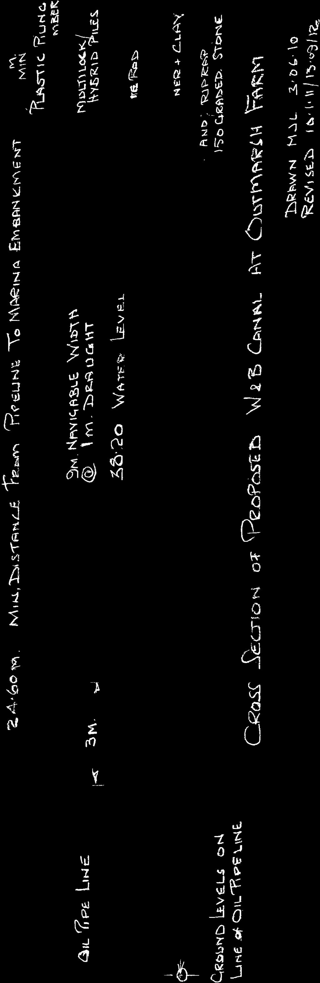
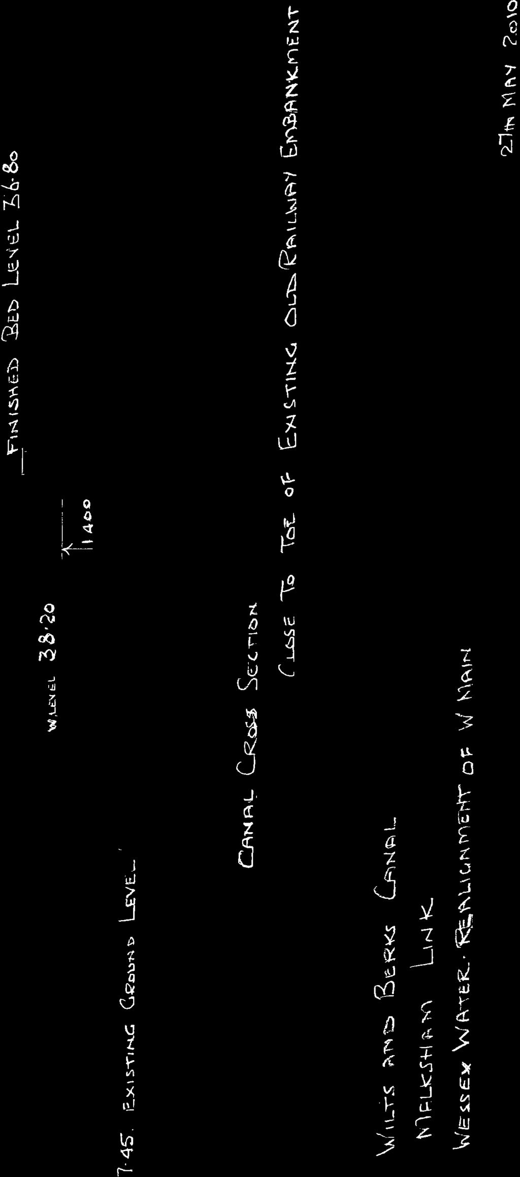
5 Technical Design The design for this proposal includes a new length of canal between Kennet & Avon canal and the River Avon, impounding of a section of the River Avon in Melksham, and a new lock adjacent to the existing weir with the following features:- New canal approximately 3km in length with 3 locks, designed to Kennet & Avon dimensions, falling a total 7.3m to the River Avon. New weir in the River Avon below Challeymead (A350) bridge raising the water level by approximately 0.5m from current ( summer flow) level. New narrow (2.1m) lock and hydropower facility, adjacent to the existing weir above Town Bridge allowing craft to be raised 2m to the river above the weir. The waterway has been designed in four parts: 1. Kennet & Avon Canal junction to Berryfield community 2. Berryfield to junction with the River Avon 3. Impoundment of River Avon from new weir below Challeymead bridge to the existing weir and sluice above Town bridge 4. River Avon from the existing sluice to junction with proposed new canal (Note as an informative the proposed new route to connect to the historic line is shown is this design) Part 1 K&A Junction to Berryfield The junction will be approx 75m. west of the original entrance to the Wilts & Berks Canal, on the same level as the K&A, without a junction lock but will include provision for stop planks. The water level in the K&A has been quoted at AOD in all previous reports but several checks, taken during 2010, have shown this to be incorrect. There is considerable variation in levels from to In the light of these results the datum level has been adjusted to AOD. Water depth on this length is 1.4m. K &A entrance to old railway embankment 1.1 A layout plan of this section is shown on Sheet1 scale 1:1250. The connection to the K&A allows 30m. swinging room into the new length with vertical banks protected with either steel or plastic revetment. The K&A Towpath will be carried over the new canal junction by an 8m span Macrete FlexiArch footbridge with 1:15 approach ramps either side. This bridge will incorporate suitable ducts to carry the fibre optic communications cable that is currently buried in the towpath Stop planks are provided, in the approach channel, to allow isolation of the new canal. The canal will have a bed width of 7m.with nominal slopes of 1:3 and a channel width of 15m. The navigable width is 9m for a boat having a draught of 1m. The length of channel shown on drawings 1,2 &3 will be on a low embankment for most of its length. 5
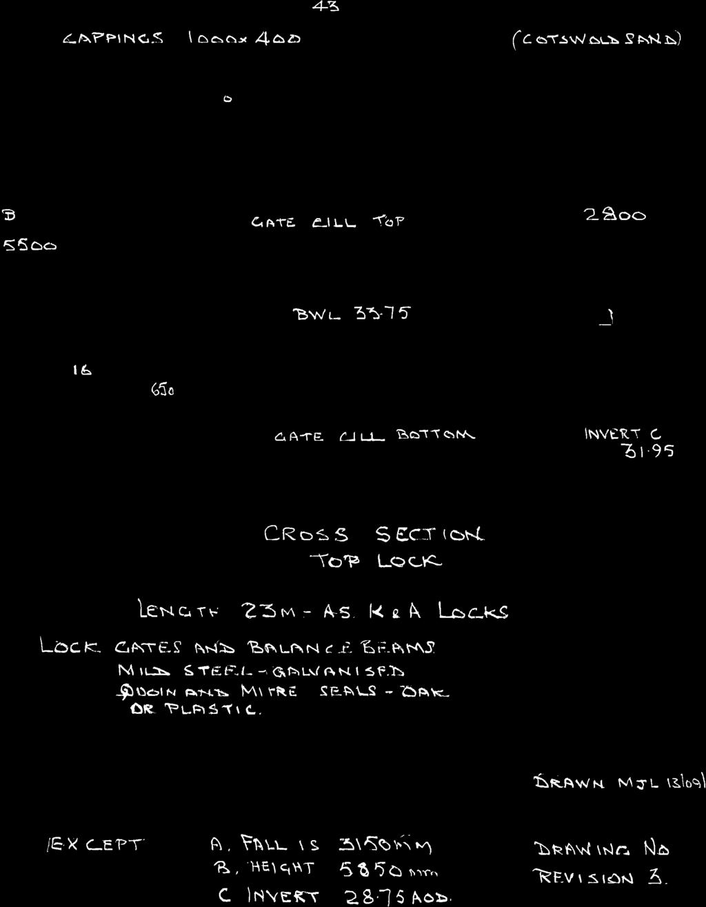
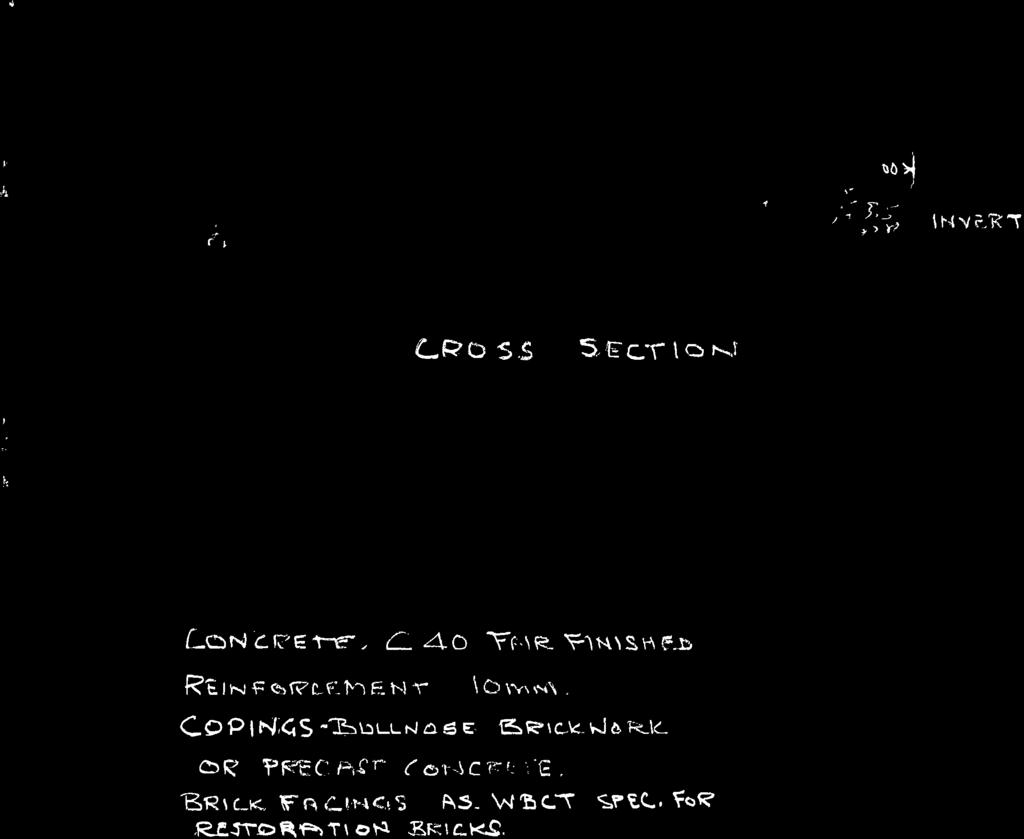
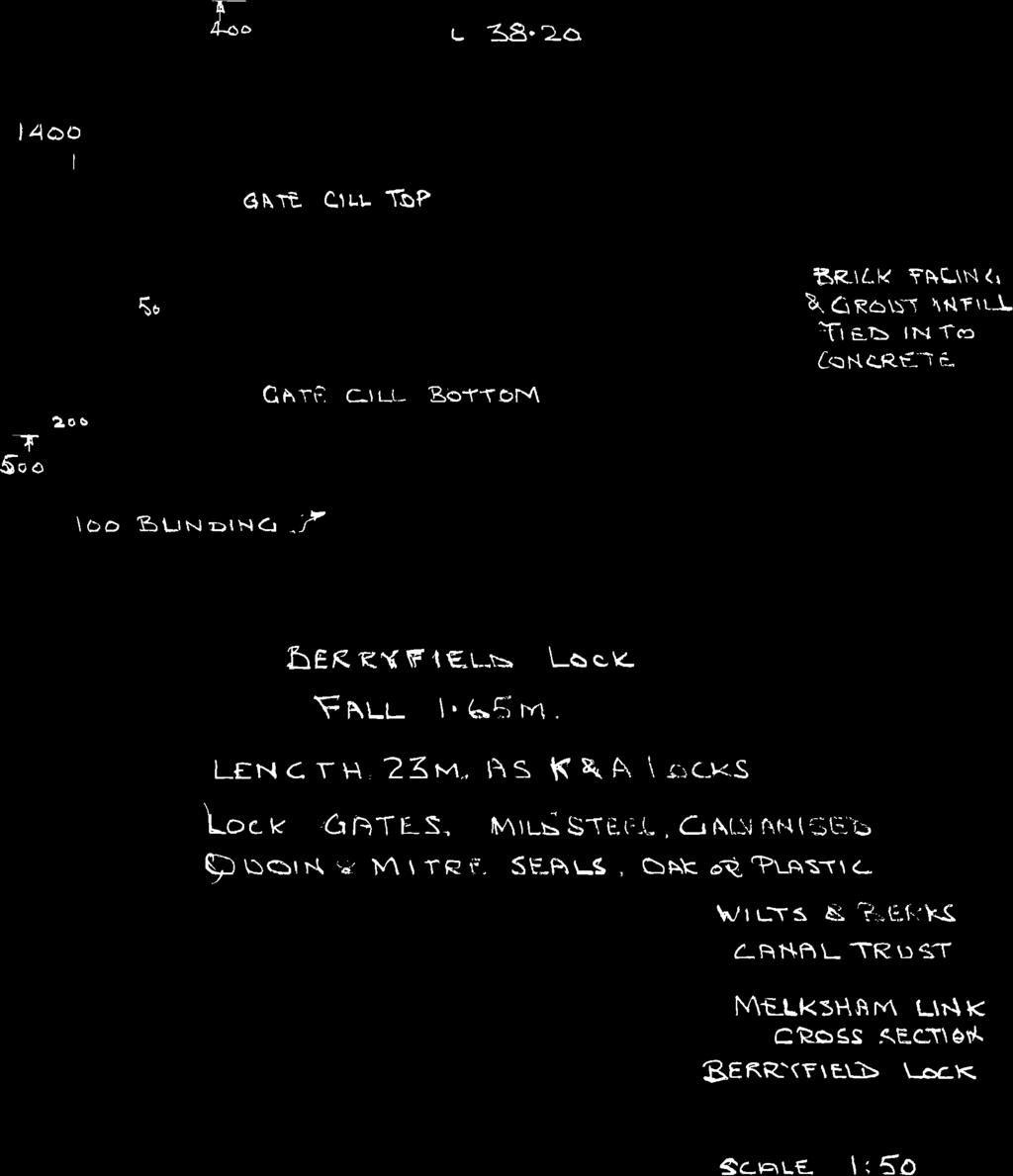
6 The position of the channel is dictated by the restriction of the Esso pipeline for part of this length and by agreement with the operator finished work will not be closer than 3m.to the pipeline. There are restrictions in the weight of construction plant working in the restricted area. 1.2 As part of this design, provision has been made adjacent to the canal for a Marina capable of accommodating 200 narrowboats, or a lesser number of wide beam, with a few residential moorings. The access will be from the suitably splayed connecting channel through a separation embankment incorporating a provision for stop planks. This will be built as a private venture and detailed proposals will be submitted as a separate planning application. 1.3 At the old railway embankment, a 5m waterway plus 3m towpath, in cutting, is proposed. This will have concrete retaining walls, possibly brick faced and bridged with a circa 1942 Bailey Bridge recovered from Frome and donated to the Trust. 1.4 This section will probably be mostly in the Oxford clay strata but, because of the limited water supply, this length will be fully lined with Rawmat sodium Bentonite lining. This will reduce bed and bank losses to the minimum possible. 1.5 Drawing No 2 shows cross-sectional details close to the old embankment where a new water main has already been laid to accommodate the canal. 1.6 The towpath is proposed to be 3m wide wherever possible with a minimum width of 2m surfaced to a standard to accommodate light plant, farm vehicles and cyclists 1.7 The length from the old railway to Berryfield is shown on Layout Plan Sheet 2. This will be a 15m wide waterway on a low embankment incorporating a 3m wide towpath as above. There will be at least one lift or swing bridge to accommodate footpaths and farm equipment. A culvert will also be required to pass a small watercourse under the canal. 1.8 The canal water surface level will be at or above existing ground levels and imported fill will be required to construct the low embankments. This can come from the Marina development or from beyond Berryfield. If the latter source is used movement of spoil will have to be along the line of the canal and length 1 cannot be completed until spoil is available from length Berryfield lock will be constructed just before the sharp bend leading into the village. Drawing 4b shows the cross section of the lock which will have a drop of 1.65m. Construction will be reinforced concrete, with local stone copings and possibly brick facings. Standard K&A gates with steel balance beams will be used although the possible use of composite steel and timber has still to be 6
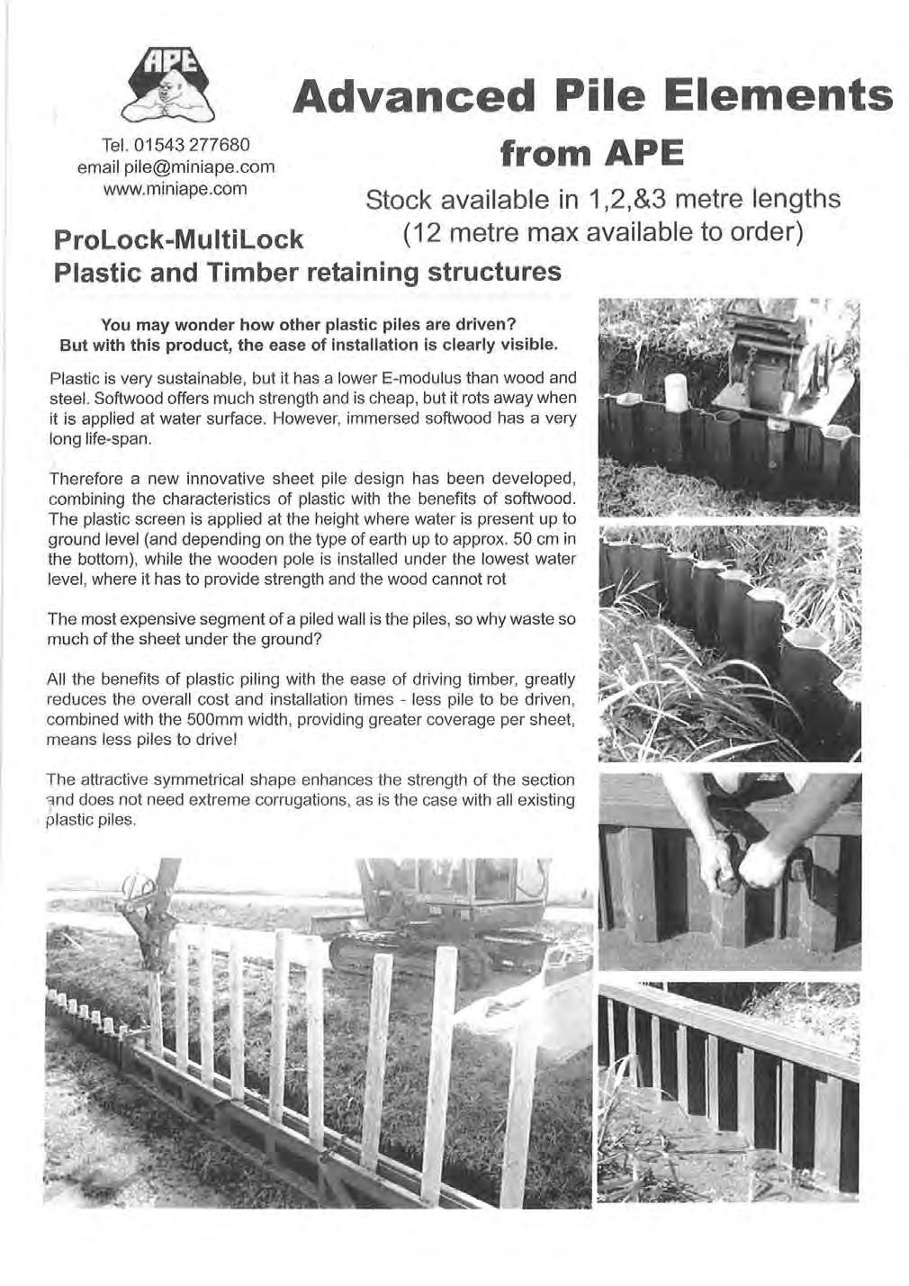
7 evaluated. Brick quadrants and heel grips, to BW pattern, will be provided at each gate The length from the lock to the aqueduct will need piled revetment on both sides. Subject to further research, this will be plastic rather than steel piling Appendix 1 shows details of plastic piling 1.11 Water supply. This length of canal is directly connected to the K&A and water will come from that source. To reduce water demand to the minimum channel lining will be used so that the biggest losses will be evaporation and transpiration. To further reduce demand, on the K&A s limited resources, back pumping will be installed to put locking water back that canal. 7
8 Part 2 Berryfield to junction with river Avon. Layout Plan Sheet 3 and Sheet 4 shows the general details for this length. Sheet 3a shows the work envisaged at Berryfield in greater detail. 2.1 There is a sharp turn into the village and the channel will have to be widened and protected with either steel or plastic piling, which will lead into an reinforced concrete aqueduct over the Berryfield Brook. This will be on skew of to the existing line of the brook This will also allow limited room for mooring and winding. Drawings no.5 & The aqueduct will be 5m.wide, plus the 3m wide towpath, and lead into a concrete channel 7m wide, with a narrow towpath, through the village. The possibility of using plastic piling instead of concrete is still being investigated. This area will be landscaped and planted and a new children s play area constructed to replace the existing one which is on the line of the canal. Due to the channel design there no mooring will be possible on this section from the aqueduct to Berryfield Lane. 2.3 Access to Berryfield village. The existing junction of Berryfield Park road with the main road will be severed and the concrete channel narrowed to 5 m. A manually operated lift bridge will be built. A new road access will be constructed to provide 2 new roads from the main road into the village, with 2 arch bridges spanning the canal. The bridges will be FlexiArch a patented, very modern, method of building arch bridges but with suitable approach ramps for current highway sight line requirements.. The external finish will be brick facings to produce a very similar appearance to the canal s original arch bridges. Appendix 2 FlexiArch system. 2.4 At the New Inn the available width is very restricted and channel width will have to be reduced to 5m, even possibly 4.5m, and the large tree removed.. It is proposed to terminate Berryfield lane with no canal crossing to Semington Road. 2.5 Downstream of Berryfield lock water levels will, at 36.55AOD, be approx. 400mm below ground level increasing to approx. 1m below ground level on the remainder of the length to top lock. Water depth will be 1.4 m through the village increasing to 1.6m depth beyond the concrete section. The depth of water is increased to 1.6m in order to provide water storage and to reduce turbulence and suspended solids arising from the passage of boats The winding hole and approach area at the end of the narrow section will need to be piled but beyond this the channel will be in a shallow cutting. This will require a simple plastic and timber piled revetment on the towpath side and a sloping bank to meet existing ground levels on the offside. Coir roll revetment may be required if the bank above he stone erosion protection is very soft. See drawing No.8 8
9 2.7 The towpath will revert to a 3m width and be surfaced to cycleway standards. 2.8 There will need to be a swing pedestrian access bridge near the 2nd. Lock to accommodate a revised footpath route. 2.9 Refuge moorings and a limited number of residential moorings are proposed part way to the next lock. Refuge moorings are essential as in a potential flood event all boats will have to move off the river Top lock. This lock is proposed to be built by volunteers and the design is being kept as a simple reinforced concrete structure. If this work is completed by volunteers it will be known as Volunteer Lock. Drawing No.4a Top water level Bottom water level Fall 2.8m Depth over cills 1.6m Lock gates BW. standard timber or, possibly, composite steel construction with steel balance beams River lock. This lock will drop the canal to river level, which of course, varies considerably depending on rainfall and ground water conditions. On the information currently available, a low summer water level of should be achievable with a 500 mm increase in water level maintained by a new weir downstream of the junction, giving a probable max fall of 3.15m. See longitudinal section Drawing. No Water supply this length of canal will be supplied from the River Avon. An automatic pumping station will be constructed near to Challeymead Bridge. This will pump water to a controlled outlet up stream of Top Lock and to another in the pound between the locks. Lockage water will discharge to the lock approach channel. There will be an initial large quantity required for the first filling, but then water will only be required to make up bed losses, evaporation and transpiration; all lockage water being returned to the river Siltation. The passage of boats along the canal will cause some sediment to be put into suspension, this will be reduced by the increased depth and cross section area of this length of canal. Additionally the pound between the locks can be deepened by up to 1m. further reducing the suspended silt. The resultant discharge to the river will, for most of the year, be less than the silt load in the river. The gate paddles on the bottom lock will be made larger than usual so that the rate of discharge will be greater than normal, which will help reduce the accumulation of silt in the approach channel The channel below the lock will be defined by revetment at or below nominal water level (similar to that used on the K&A Canal).The marginal area between the channel and the banks will be planted with reed and other native marginal plants to provide further habitat enhancement. 9
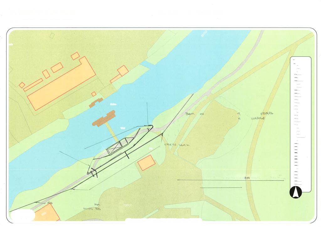
10 Part 3 Impounded River Avon from canal junction to existing weir and sluice 3.1 Details of this section are shown in Layout Plans Sheet Melksham weir and sluice were built in 1958 to provide flood relief to Melksham. The Channel from the weir to below Challymead bridge is very wide and not as stable as the natural balance of the channel downstream of the widened section. There is considerable siltation in the area of Town Bridge and erosion at Challeymead Bridge and several long lengths of deep channel. 3.3 In order to make the River Avon navigable up to Melksham it is proposed to construct a low weir downstream of the junction with the new canal, at the end of the widened section, where the bed level is high. This weir will raise the water level by approx. 500mm ; incorporate a fish pass, canoe slalom and have a crest level of to retain a water level of approx AOD. This will be sufficient, with minor dredging, to give a navigable depth of 1.6m up to the existing weir and sluice. The dredged bed level will be which will mean removing the high area at Town Bridge and under Challeymead Bridge, where erosion and siltation has completely altered the correct channel location. The dredged width will be a navigable channel approx 12m wide and the spoil will be used to reshape the left bank in the area of Challeymead bridge and minor bank regrading. The major part of the channel is already lower than the required depth. Drawing 10 shows a longitudinal section of the river with the proposed levels superimposed. 3.4 The new weir will have a weir length of 20m. and be slightly curved in plan. A canoe weir/slalom will be constructed close to the North bank. Further discussion is required with canoeists to decide the design of this structure On the South side a 4m. x1m. tilting weir sluice gate will be constructed; this will allow the level to be dropped for inspection, maintenance and minor adjustments to the water level. This sluice can also be left open in the winter and will reduce the rate of siltation. Alongside the sluice there is room for a 600mm wide fish pass. Drawings 11 and In Melksham the existing weir and sluice gate will be retained and a new narrow lock built on the South side(left bank) of the weir. This will mean that wide beam boats will not be able to navigate beyond the existing weir; there is however ample room on the south bank to re-profile the bank to provide bankside or pontoon moorings and improve the general appearance of the river corridor. Drawing no There will still be adequate fall at this weir to make hydropower generation a practical proposition and drawing 9 also shows a possible position for an installation. 10
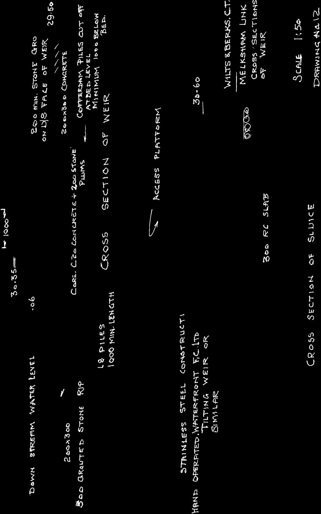
11 3.7 Melksham lock. The proposed lock will be a conventional narrow lock and the same length as the K&A locks. This lock will be subject to regular flooding as it will be adjacent to the existing weir wall. An additional Hydraulic Modelling Report has been commissioned from Messrs. Black and Veatch which indicates that the construction will have no measurable effect on flood levels if built as a standard narrow lock. As a flood relief channel it could provide a very modest reduction in flood levels of 20-40mm. The high additional cost of providing this option is not justifiable, but the facility to open top and bottom gates together can be provided. 3.8 Basic lock data Top Gates. Oxford Canal pattern. Ground paddles only Crest level of weir AOD Assumed summer level. 150mm over weir Cill level ie. 1.5 m below weir crest level. There will therefore adequate depth for navigation if level drops to crest level. Overspill level. Top gates Flood level. 1:100 year Coping level. As existing piling Bottom Gates Mitre Gates. Single paddle in each gate Downstream water level approx. Lock fall 2360mm Lock gate cill level Lock island The existing piling to remain untouched. New steel piling to be driven to connect with the existing to form a bullnose up stream and downstream of the lock and the wall of the lock. Tie rods to tie across the island and to be surfaced with an reinforced concrete deck detailed to suit the proposed hydropower scheme. Towpath side Steel sheet piling to start approx. 40m upstream of the forebay. Concrete coping level Lock wall piled with coping level of Downstream of lock piling continued for 40m. Coping level With the high risk of flooding the towpath and bank, including the piled lengths upstream and downstream, up to the level, need to be protected from erosion with pitched stone or block revetment. The existing structure is piled on both banks and piling will be in keeping, but the lock chamber could have a cosmetic finish of brick or stone if required. 3.9 Basic Challeymead weir data Main weir. Length 20m broad crested type with upstream and downstream approaches sloped at 30 degrees. 11
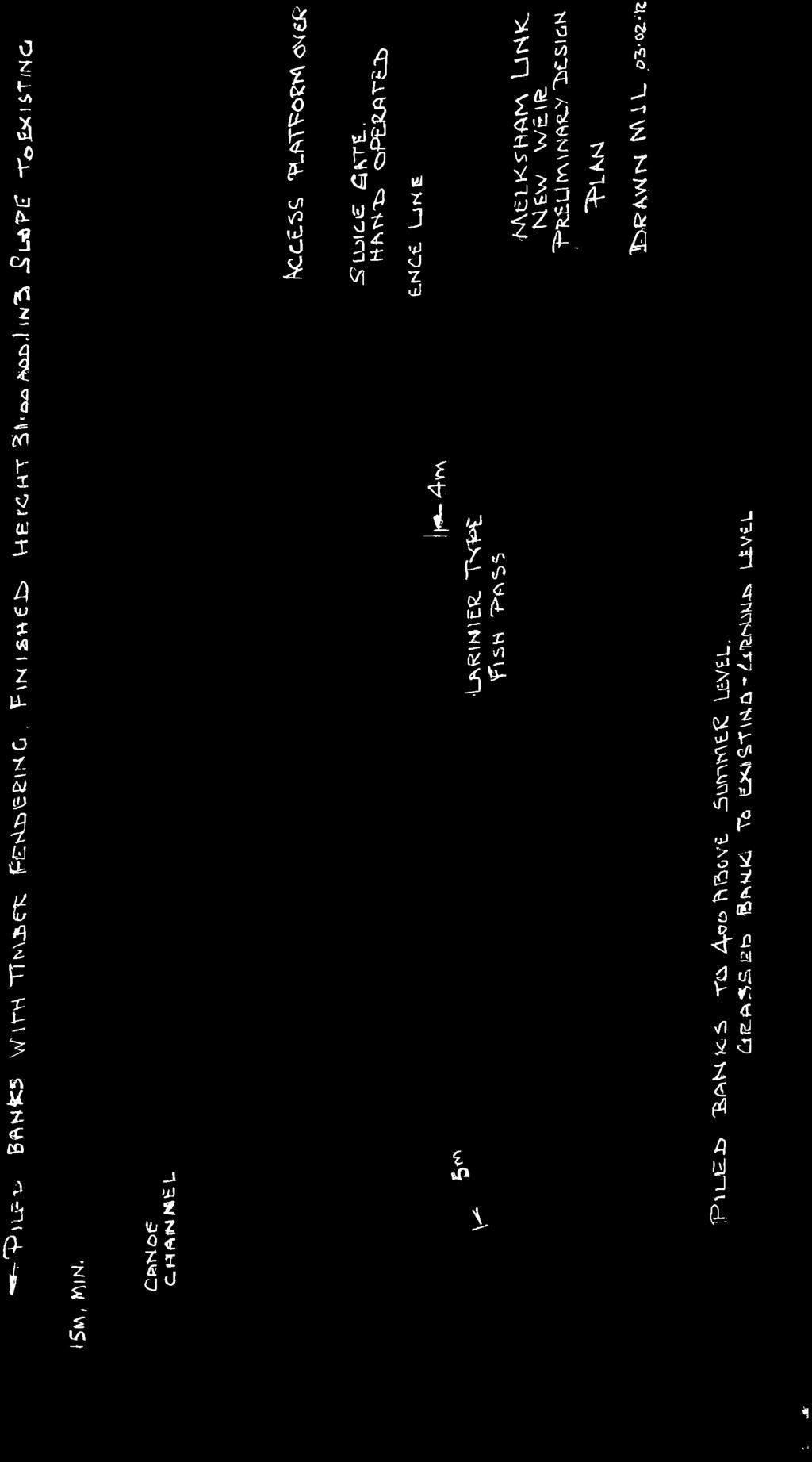
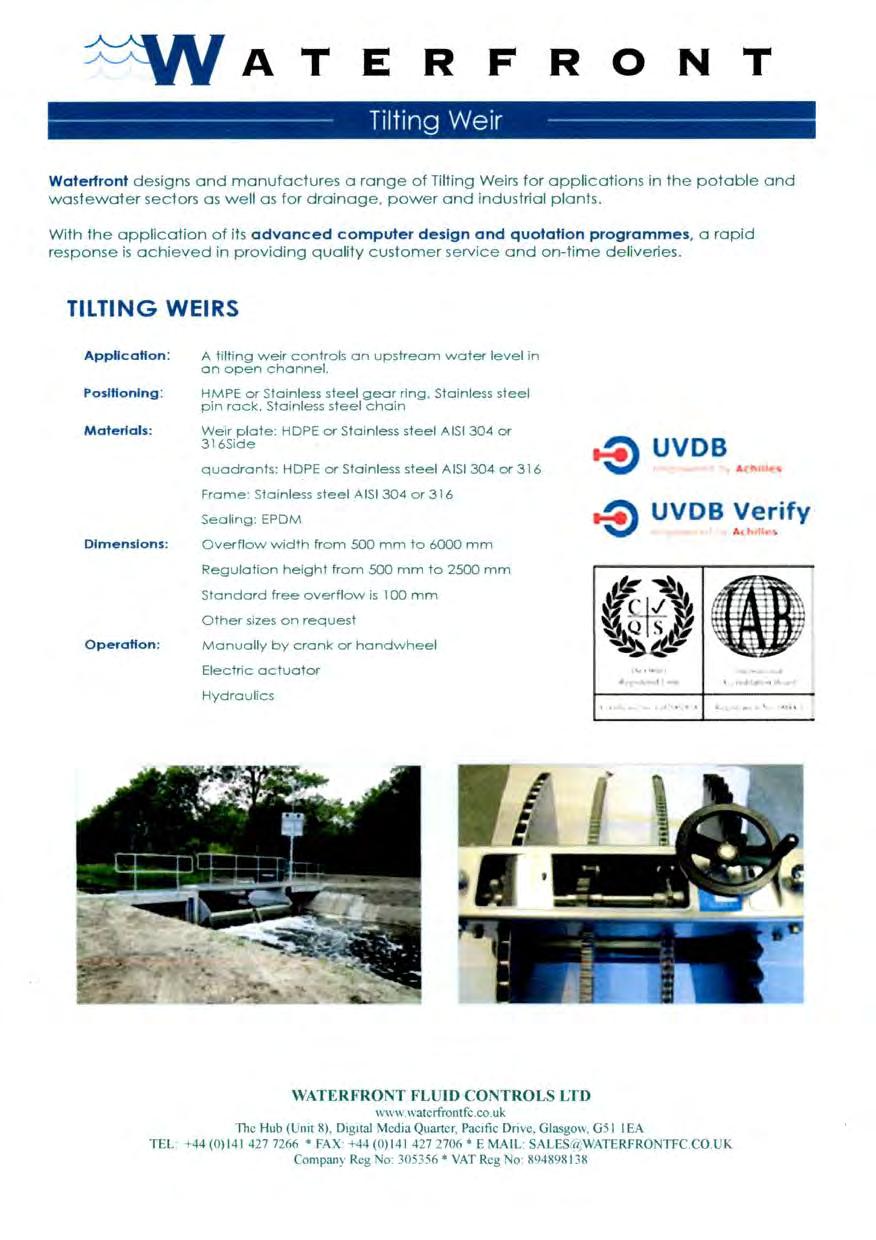
12 The drop over the weir will vary with changes in water level but under average summer flows will be 0.54m. In flood conditions the downstream water level will rise to a point where the weir is completely covered i.e. drowned out. This is likely on 1:2 year flood return period. Adjustable sluice. A tilting weir of the type produced by Waterfront Fluid Controls Ltd is proposed on the south bank. This will allow the retained level to be dropped so the limited maintenance and inspections can be carried out during low flow periods. It will also allow a small amount of fine adjustment in retention level and subject to experiment there may be a reduction in silt accumulation if left open for part of the winter. Fish Pass A 800mm wide Larinier type fish pass will be constructed next to the sluice. This type of fish pass has closely spaced baffles along its length making an easier passage for fish. The provision of an access platform over the sluice will also provide easy access to the pass. Canoe Channel. A channel 5m wide to the approved design of the British Canoe Union will be built on the north bank. With the low drop over this weir both the channel and the main weir will be particularly attractive to canoeists and it is likely to become a very popular training length of the river. Simple landing stages will be constructed above and below the weir. It is not proposed to fit a boom at the weir and appropriate warning signs will warn boaters and canoeists. 12
13 Part 4 River Avon above Melksham Gate ( existing sluice) 4.1 Details of this section are shown on Layout Plan Sheet Upstream of the Melksham Gate (existing sluice). The left bank up stream of the sluice is suitable for the development of mooring space and an improved towpath. An outline design for a simple revetment to protect the river bank and improve boat access has been prepared for the canoe club and would be suitable for the whole bank beyond the new piling. 4.3 Beyond the river the drawings indicate the proposed route to link to the historic line of the canal north of Melksham. 13
14 Part 5 Services Information has been obtained from the various service providers. The work expected to be required to deal these is summarised:- 5.1 Fibre optic cables. As already noted these will be diverted over the new footbridge at Semington 5.2 Esso pipeline. The alignment of the canal runs parallel to the pipeline but it is designed to be just outside the restricted width of approach to the pipe line required by the Operator. 5.3 Water. The main problem expected to arise has been dealt with and Wessex Water s new main has been laid with adequate cover under the set out position for the canal. At the K&A junction the main crossing under the K&A will have to be extended to pass under the new line and a new valve complex will have to be constructed. The alignment of the main is avoided by the layout shown for the junction and Marina. Water service pipes will have to be re-located at Berryfield where the canal will cross them. 5.3 Foul sewers A 200 diam crosses the canal line near Berryfield. With a canal depth of 1.4m there should be clearance under the canal based on the information obtained. A rising main crosses under the Berryfield Brook at Berryfield this should not cause a problem but may be to high to pass under the concrete section and may need lowering. 5.4 Storm sewers. 450 and 600mm storm drains cross the line of the canal near to the 2 locks and diversions will be required. The sewage treatment works outfall, Southbrook outfall and a storm water outfall are downstream of the new weir so are not affected. There are sewer overflow outfalls and road drains discharging to the river above the new weir but the small rise in retained water level should have little effect. 5.5 Overhead cables. Some diversion or temporary raising may be required but most of the overhead lines can be worked under or avoided. 14
15 Layout Plans & Maps 15

16 Layout Plan Sheet 1 Do not scale from this drawing-see separately submitted drawings 16
17 Layout Plan Sheet 2 Do not scale from this drawing-see separately submitted drawings 17

18 Layout Plan Sheet 3 Do not scale from this drawing-see separately submitted drawings 18

19 Layout Plan Sheet 3a Do not scale from this drawing-see separately submitted drawings 19

20 Layout Plan Sheet 4 Do not scale from this drawing-see separately submitted drawings 20

21 Layout Plan Sheet 5 Do not scale from this drawing-see separately submitted drawings 21

22 Layout Plan Sheet 6 Overall Scheme Do not scale from this drawing-see separately submitted drawings 22
23 Engineering drawings /sketches 23
24 Drawing No. 1 Typical cross section of channel between K&A and the railway embankment Scale A4 24
25
26 Drawing No.2. Cross section as set out at new water main crossing at Outmarsh Farm. Scale
27
28 Drawing No.3 Typical cross sections : Between railway embankment and Berryfield Village & between Berryfield and river Avon. Scale

29
30 Drawing No.4a section lock construction Scale A4
31
32 28 Drawing No.4b section Berryfield lock construction Scale
33
34 29 Drawing 4c sections lock construction at Melksham Gate Scale A4 See also separately submitted drawing WBCT 10/008
35
36 30 Drawing No.5 Berryfield brook aqueduct Elevations looking upstream and downstream Scale
37
38 31 Drawing No.6 Berryfield Brook. Plan & Section Scale
39
40 32 Drawing No.7 Longitudinal section- locks leading down into river Avon Vertical Scale 1:50 Horizontal Scale : 1:1250 (note drawing extends over 2 A4 pages)
41
42
43 33 Drawing No.8 Alternative revetment methods Scale A4

44
45 34 Drawing No.9a Elevation and section Melksham Gate Narrow Lock & Hydro power scheme Scale See also separately submitted drawing WBCT 10/008 & WBCT 10/009
46
47 35 Drawing No.9b Melksham Flood Gate Narrow Lock & Hydro power scheme plan layout Scale A3 See also separately submitted drawing WBCT 10/008 & WBCT 10/009

48
49 36 Drawing No.10 Amended Black & Veatch Cross Longitudinal section of river from new weir to canal junction upstream of existing weir.

50
51 37 Drawing No.11 Challeymead Weir Plan Scale
52
53 38 Drawing No.12 Challeymead Weir cross section Scale A4
54
55 39
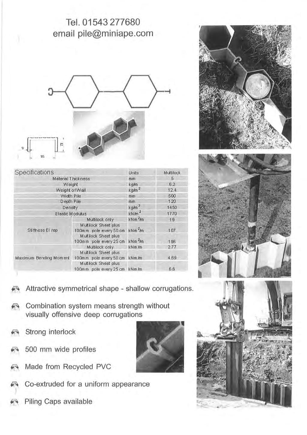
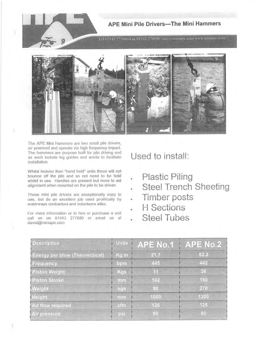
56 Appendix 1 Details of Multi-lock plastic piling.
57 41
58 42
59 43
60 Appendix 2 Macrete Bridges 44
61
62 46
63 47
64 48
65 49
66 50
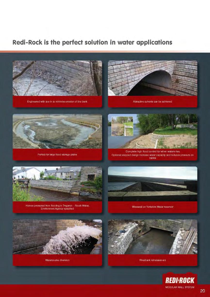
67 Appendix 3 Redi-Rock Information 51

68 52

69 53
70 54
Wilts & Berks Canal. Appendix E: Hydrology and Hydraulics CONTENTS 1. INTRODUCTION 2 2. HYDROLOGY 2 3. HYDRAULIC MODEL 2 4.
 Wilts & Berks Canal Melksham River Route Study Appendix E: Hydrology and Hydraulics CONTENTS 1. INTRODUCTION 2 2. HYDROLOGY 2 3. HYDRAULIC MODEL 2 4. CANAL OPERATION 3 5. WEIR DESIGN 4 6. FLOOD RISK 5
NON TECHNICAL SUMMARY. Introduction
 NON TECHNICAL SUMMARY Introduction An (ES) has been prepared on behalf of Wilts & Berks Canal Trust (the applicant) to accompany a full planning application for the restoration scheme. The development
GOOSENECK SWAMP INFORMATION DAY - Saturday 14 th December 2013
 GOOSENECK SWAMP INFORMATION DAY - Saturday 14 th December 2013 Progress of a restoration trial at Gooseneck Swamp - Grampians National Park, Victoria Gooseneck Swamp is situated at the far south-eastern
Cotswold Canals Restoration
 Gloucestershire Society for Industrial Archaeology Cotswold Canals Restoration Phase 1b. Saul Junction to The Ocean, Stonehouse Project S01 Stroudwater Canal Features Influenced by the Ship Canal to Gloucester
Gatwick Stream Riverside Garden Park, Horley
 Gatwick Stream Riverside Garden Park, Horley An Advisory Visit by the Wild Trout Trust January 2014 1 1. Introduction This report is the output of a Wild Trout Trust visit to the Gatwick Stream in Horley,
12. Sowter Road Introduction Christchurch Court
 12. Sowter Road 12.1 Introduction 12.1.1 The flood defences at Sowter Road are located between St Alkmund s Way and the Silk Mill on the west bank of the River Derwent. 12.1.2 This site is split into the
Initial OPW Designation APSR AFRR IRR Co-ordinates Easting: Northing: River / Catchment / Sub-catchment Type of Flooding / Flood Risk
 Location: Shannon International Airport, Co. Clare Unique ID: 275484 (from PFRA database) Initial OPW Designation APSR AFRR IRR Co-ordinates Easting: 137674 Northing: 161045 River / Catchment / Sub-catchment
Report to: Greater Cambridge Partnership Joint Assembly 18 January A10 Foxton level crossing bypass and travel hub
 Report to: Greater Cambridge Partnership Joint Assembly 18 January 2018 Lead officer: Chris Tunstall GCP Director of Transport A10 Foxton level crossing bypass and travel hub 1. Purpose 1.1 The list of
Agenda Report. Spruce Street Outlet Drainage Improvements Tower Road Relief Sewer
 Agenda Report Subject: Prepared By: Spruce Street Outlet Drainage Improvements Tower Road Relief Sewer Steven M. Saunders, Director of Public Works/Village Engineer Date: August 12, 2012 On March 8, 2012
Mr. Michael Malone CPS Energy 145 Navarro Street San Antonio, Texas Project No
 January 15, 2016 Mr. Michael Malone 145 Navarro Street San Antonio, Texas 78205 Project No. 0328985 Environmental Resources Management CityCentre Four 840 West Sam Houston Pkwy N. Suite 600 Houston, Texas
A487 PONT SEIONT ARCHAEOLOGICAL RECORDING REPORT NO Y mddiriedolaeth Archaeolegol Gwynedd Gwynedd Archaeological Trust
 A487 PONT SEIONT ARCHAEOLOGICAL RECORDING REPORT NO. 148 Y mddiriedolaeth Archaeolegol Gwynedd Gwynedd Archaeological Trust A487 PONT SEIONT ARCHAEOLOGICAL RECORDING prepared for Welsh Office Highways
Hydro-Electric Schemes Compliance Report June June 2013
 File Reference: 4.00212 Significance of Decision: Receives Only - No Decisions Report To: Operations, Monitoring and Regulation Committee Meeting Date: 20 June 2013 Report From: Nick Zaman, Pollution Prevention
KENNET & AVON VISITOR MOORING REVIEW BATH TO FOXHANGERS
 KENNET & AVON VISITOR MOORING REVIEW BATH TO FOXHANGERS 09 March 2015 Introduction The Kennet & Avon Local Plan recommended that a review of the visitor moorings between Bath and Foxhangers be carried
Specification for Grip blocking using Peat Dams
 Technical Guidance Note 1 Specification for Grip blocking using Peat Dams 1. Introduction Moorland drains (grips) have been dug across much of the Yorkshire upland peatlands. Many of these grips have become
St. Patrick s Street Development Brief
 St. Patrick s Street Development Brief Bardas Chorcai Cork Corporation August 2001 Contents Introduction and background The Development Brief Area Protected and valuable buildings Urban context Objectives
Consultation on Town Quay Mooring Redevelopment Proposals
 Consultation on Town Quay Mooring Redevelopment Proposals Lymington Harbour Commissioners (LHC) would like your views on its proposals to redevelop the Town Quay area to meet the changing market requirements
Amended Maintenance Dredge Spoil Management Plan. Shute Harbour Marina Resort
 Amended Maintenance Dredge Spoil Management Plan Shute Harbour Marina Resort Amended Maintenance Dredge Spoil Management Plan Quality Information Document Ref Amended Maintenance Dredge and Spoil Maintenance
Welcome KROSNO CREEK DIVERSION PROJECT CLASS ENVIRONMENTAL ASSESSMENT
 Welcome KROSNO CREEK DIVERSION PROJECT PUBLIC INFORMATION CENTRE # 1 Tonight s Presentation Study Overview Background Existing Conditions Alternative Solutions Preliminary Preferred Solution Next Steps
Stainforth & Keadby Canal Installation of Multiuser Path
 Stainforth & Keadby Canal Installation of Multiuser Path Introduction North Lincolnshire Council has entered into an agreement with Canal & River Trust to develop proposals to introduce a multiuser path
K SIGNAGE & TRAFFIC CONTROL. Table of Contents
 Table of Contents K1. ACCOMMODATION OF TRAFFIC... 1 K2. MINIMUM CONSTRUCTION SIGNING... 1 K3. SUBDIVISION SIGNS... 2 K4. TRAFFIC CONTROL DEVICES... 2 K4.1 Traffic Signs Regulations... 2 K4.2 Materials...
Centurion Way Chichester
 Centurion Way Chichester Work book of plans to show details of the Centurion Way, its links, and potential developments and enhancements from linking to the South Downs National Park all the way to the
Berkshire Local Transport Body. Pro- forma for Consideration of a Transport Scheme at Programme Entry Stage. Section 1: Headline Description
 Berkshire Local Transport Body Pro- forma for Consideration of a Transport Scheme at Programme Entry Stage Section 1: Headline Description Local Authority Royal Borough of Windsor and Maidenhead Number
VERSION DATE OF ISSUE DESCRIPTION PREPARED CHECKED APPROVED Technical note HHP DKA OYBE
 DRAMMENREGIONENS VIRKESTERMINALER DEVELOPMENT OF NEW TIMBER TERMINAL NAVIGATION AND BERTH LOCATION STUDY ADDRESS COWI A/S Parallelvej 2 2800 Kongens Lyngby Denmark TEL +45 56 40 00 00 FAX +45 56 40 99
Maidenhead Bridge. Proposed Work
 W1.1 Maidenhead Bridge Proposed Work The Maidenhead Bridge over the River Thames at Maidenhead is a Grade II* listed structure. Installation of overhead electrification on top of the structure would be
Barnsley, Dearne & Dove Canals Trust HS2 Mitigation Options
 Page 1 of 13 Barnsley, Dearne & Dove Canals HS2 Mitigation Options December 2013 Elsecar Branch, Top Pound Prepared by Ulrich Signer, Director, BDDCT Mike Silk, Engineer, BDDCT The Barnsley, Dearne and
TOWPATH AND ACCESS IMPROVEMENTS BIRMINGHAM AND BLACK COUNTRY CANALS
 TOWPATH AND ACCESS IMPROVEMENTS BIRMINGHAM AND BLACK COUNTRY CANALS BACKGROUND Department for Transport grants Early 2013, the Parliamentary Under-Secretary for Transport, Norman Baker MP, announced 62m
A63 Castle Street, Hull HullBID Network Lunch 24 August 2017
 A63 Castle Street, Hull HullBID Network Lunch 24 August 2017 James D Leeming Senior Project Manager What we will cover today? Introduction to Highways England and the Road Investment Strategy A63 Scheme
Shallow IC of 5
 Shallow IC 250 1 of 5 Description 250mm diameter polypropylene inspection chamber for adoptable and non-adoptable applications. Compliant with Sewers for Adoption 7th edition [SfA7]. Single unit with integral
Presentation Overview
 DON NARROWS Historical and Existing Conditions March 29, 2008 Presentation Overview 1. Project Location and Background 2. Historical Context How did the Don Narrows Come to Be? 3. The Today 4. Next Steps
Felixstowe Branch Line FAQ
 Felixstowe Branch Line FAQ How was the location of the track doubling work decided? We undertook a study to identify how to meet the freight demand along the Felixstowe Branch Line by modelling the route.
APPENDIX D: SUSTAINABLE TRAIL DESIGN. APPENDICES Town of Chili Parks and Recreation Master Plan Update
 APPENDIX D: SUSTAINABLE TRAIL DESIGN APPENDICES Town of Chili Parks and Recreation Master Plan Update Sustainable Trail Construction Sustainable trails are defined by the US Forest Service as trails having
HYDRAULIC DESIGN OF THE TOURISTIC BERTHING IN ASWAN CITY
 HYDRAULIC DESIGN OF THE TOURISTIC BERTHING IN ASWAN CITY Dr. Hossam El-Sersawy Researcher, Nile Research Institute (NRI), National Water Research Center (NWRC), Egypt E-mail: h_sersawy@hotmail.com Dr.
Energy from Waste and Recycling Facility Trident Park, Cardiff. Planning History. January 2010 SLR Ref: B
 Energy from Waste and Recycling Facility Trident Park, Cardiff Planning History January 2010 Ref: 402-0036-0306B Viridor Ltd. i 402/0036/00306B CONTENTS 1.0 INTRODUCTION... 1 2.0 GENERAL HISTORY... 3
AQUAVALVE THROUGH BULKHEAD
 AQUAVALVE THROUGH BULKHEAD The Tru-Design Aquavalve is the most versatile valve on the market today. The Aquavalve is designed and made in New Zealand, for demanding marine sanitation applications. The
LLANBEDR ACCESS IMPROVEMENTS
 LLANBEDR ACCESS IMPROVEMENTS NON-MOTORISED USER SUPPLEMENTARY REPORT CPF: 5111 Client: Gwynedd Council Document Control Sheet Document Title: Document Author: Project Manager: Project Title: A496 Llanbedr
A. CONCLUSIONS OF THE FGEIS
 Chapter 11: Traffic and Parking A. CONCLUSIONS OF THE FGEIS The FGEIS found that the Approved Plan will generate a substantial volume of vehicular and pedestrian activity, including an estimated 1,300
NORTH WEST SPRING LOCAL WATERWAY FORUM PRE-MEETING QUESTIONS
 USER QUESTION RESPONSE John Fiddies Wheelton Boat Club As a result of failed temporary repairs undertaken to a number of lock chambers during the Winter Stoppages has safety been compromised? The most
Chapter 25 Route Window SE6 Plumstead portal. Transport for London
 Chapter 25 Route Window SE6 Plumstead portal PLUMSTEAD PORTAL 25 Route Window SE6 Plumstead portal Introduction 25.1 The Crossrail route will follow the present alignment of the North Kent Line from a
PUBLIC INQUIRY QUESTION
 REFERENCE NO. : PIQ / 019 PUBLIC INQUIRY QUESTION RAISED BY: The Inspectors DATE: 20/02/17 RESPONDED BY: Ben Sibert DATE: 10/03/17 SUBJECT: Engineering Proof of Evidence Elucidations The attached document
LYNDHURST NEW URBAN DEVELOPMENT AREA STRUCTURE PLAN. Lyndhurst New Urban Development Area Structure Plan OUTCOMES AND PERFORMANCE STANDARDS
 APPENDIX 15.1-3 LYNDHURST NEW URBAN DEVELOPMENT AREA STRUCTURE PLAN Purpose of the Structure Plan Lyndhurst New Urban Development Area Structure Plan OUTCOMES AND PERFORMANCE STANDARDS LSP-P1 The District
RE-PRICING OF 12 MONTH MOORING PERMITS 2015 MOORINGS AREA REPORT FOR BERKS, WILTS & AVON
 RE-PRICING OF 12 MONTH MOORING PERMITS 2015 MOORINGS AREA REPORT FOR BERKS, WILTS & AVON Introduction This report provides the rationale for mooring price decisions for 2015. VAT is payable at the rate
PORTISHEAD BRANCH LINE PRELIMINARY ENVIRONMENTAL INFORMATION REPORT VOLUME 4 APPENDIX Water Receptors
 PORTISHEAD BRANCH LINE PRELIMINARY ENVIRONMENTAL INFORMATION REPORT APPENDIX 17. 3 Water Receptors Contents Section Page 1 Water Receptors... 1-1 1.1 Surface Water Features/Receptors in the Study Area
GARFIELD BRIDGE. Building A Bridge to No-Where
 GARFIELD BRIDGE Building A Bridge to No-Where OCEANA COUNTY LOCATION Garfield Road leads to Stony Lake Outlet, a Benona Township park and popular Lake Michigan access GARFIELD BRIDGE OVER STONY CREEK
Prince Albert Road Towpath Ramp, Camden Feasibility Report
 Prince Albert Road Towpath Ramp, Camden Feasibility Report Function Location: RE-004 Date: 25 October 2012 Report No: 5016-UA003174-UT31R-03 Prince Albert Road Towpath Ramp, Camden Feasibility Report
How do you get two buses to pass safely on something
 Everybody back on the bus The world s longest guided busway is almost ready in Cambridgeshire. Mark Smulian finds out how it was built, and why the county council didn t want a railway or road Photographer
The safe & affordable install
 QSLG1000 Quick-Sling SPECS QSLG1000 Each arm attaches to wood using 2 zip screws for stability & a 4 through bolt & wing nut for security. Installs to steel using steel beam adapters. 28 points of anti-vibration
Hay Wood, Rowington and Baddesley Clinton - Warwickshire
 Hay Wood, Rowington and Baddesley Clinton - Warwickshire Starts at Lay-by alongside Hay Wood 2 hours 30 minutes 5.5miles 8.8km Leisurely ID: 0.683 Developed by: John Clift Checked by: Andy Page www.ramblersroutes.org
THE WELSH MINISTERS STATEMENT OF REASONS
 THE WELSH MINISTERS The Welsh Ministers (The M4 Motorway (Junction 23 (East of Magor) to West of Junction 29 (Castleton) and Connecting Roads) and The M48 Motorway (Junction 23 (East of Magor) Connecting
5.7 Local road upgrades
 5.7 Local road upgrades Local roads around the St Peters interchange and the intersection of Campbell Road and Euston Road would be upgraded to ensure safe and efficient connections with the New M5, and
DRAFT. Dorabelle Campground Rehabilitation
 DRAFT Dorabelle Campground Rehabilitation September 2012 1.1 REGIONAL SETTING AND PROJECT LOCATION The Dorabelle Campground is located on the western shore of Shaver Lake in Fresno County, California (Section
TIMBER BOLLARDS TYPE I. TYPE ll TS mm Radius 150 x 100 white painted Timber post dia Timber Post. Ground Level NOTES:
 30 95 15 20mm Radius x 100 white painted Timber post 900 700 125 dia Timber Post Ground Level 500 500 TYPE I TYPE ll NOTES: 1. Type I Bollards are generally to be installed in grass verge areas. 2. Type
Texas Department of Transportation Corpus Christi District. Corpus Christi Harbor Bridge
 Texas Department of Transportation Corpus Christi District Corpus Christi Harbor Bridge Presented by Russel W. Lenz, P.E. Corpus Christi District Engineer For 2009 Texas Ports and Waterways Conference
WELCOME TO PROJECT EVERGREEN 3 CHILTERN S PROPOSED NEW OXFORD TO LONDON ROUTE
 PROJECT EVERGREEN 3 WELCOME TO PROJECT EVERGREEN 3 CHILTERN S PROPOSED NEW OXFORD TO LONDON ROUTE Chiltern Railways is proposing a railway improvement scheme between Oxford and Bicester (the Evergreen
Header i
 Header i 048285014.10 Header Sub Title Body Text here. Body text here. Body text here. Section 1... 1 Executive Summary... 1 Opportunities and Constraints... 3 Overall Opportunities and Constraints Map
Thirteenth International Water Technology Conference, IWTC , Hurghada, Egypt 1249
 Thirteenth International Water Technology Conference, IWTC 13 2009, Hurghada, Egypt 1249 EVALUATION OF LOCAL SCOUR AROUND BRIDGE PIERS (RIVER NILE BRIDGES AS CASE STUDY) Sherine Ismail Assoc. Prof., Survey
FEASIBILITY CRITERIA
 This chapter describes the methodology and criteria used to evaluate the feasibility of developing trails throughout the study areas. Land availability, habitat sensitivity, roadway crossings and on-street
03 Opportunities and Strategies Union Canal Study 17
 03 Opportunities and Strategies 17015 Union Canal Study 17 Introduction This chapter summarises the issues, opportunities for improvement and proposed strategy outcomes of the study of the towpath. The
Customer consultation
 Customer consultation Anglian Waterways navigation charges 2018/19 July 2017 Introduction We need to increase the boat registration charges payable for any boat kept, used or let for hire on our Anglian
Level Crossings Configuration Standards
 Discipline: Engineering (Track & Civil) Category: Standard Level Crossings Configuration Standards ETD-16-04 Applicability New South Wales CRIA (NSW CRN) Primary Source ARTC NSW Standard XDS 01 Document
Appendix N MAINTENANCE DREDGING STATEMENT OF NEED & PERMIT COMPLIANCE. North Thousand Islands Management Plan Appendices
 Appendix N MAINTENANCE DREDGING STATEMENT OF NEED & PERMIT COMPLIANCE North Thousand Islands Management Plan Appendices Maintenance Dredging Statement of Need & Permit Compliance The waterways, which consist
The Holes Creek Bridge Replacement By Bradley McClelland
 The Holes Creek Bridge Replacement By Bradley McClelland Each time there is a heavy rainstorm, the folks along Sheffield Road in the Dayton, Ohio suburb of West Carrollton have cause to be concerned. Holes
Historic NIAGARA S SOUTH COAST. Welland Canal. History of the Welland Canal in Port Colborne. Uncharted Unexpected.
 Historic NIAGARA S SOUTH COAST Welland Canal History of the Welland Canal in Port Colborne Uncharted Unexpected www.portcolborne.ca The Welland Canal was originally established as solution to summer water
Waterways Management Program
 Waterways Management Program 2017-2021 Table of Contents GCWA WATERWAYS MANAGEMENT PROGRAM 2017-2021 3 Gold Coast Waterways Management Strategy 2014-2023 3 Waterways Authority Funding & Investment 4 Table
Planning Committee. Thursday, 26 May 2016
 Planning Committee Thursday, 26 May 2016 Attendees: Substitutes: Councillor Lyn Barton (Member), Councillor Helen Chuah (Member), Councillor Theresa Higgins (Chairman), Councillor Brian Jarvis (Member),
Porter Fk. #1. All unauthorized items removed as per FS & Rec Res guidelines. Footbridge may be needed for wheel chair access and for safety
 APPENDIX D Lot Specific Permit Compliance & Forest Plan (FP) Requirements Porter Fork Recreation Residence Tract (Items noted were documented in compliance letter, 8/12/2005, sent to all Rec. Residence
Appendix 8 Sawston Greenway Review
 Appendix 8 Sawston Greenway Review Nigel Brigham & Associates A report for 1 Introduction This report is based on fieldwork carried out in 2016 to review the Greenway network around Cambridge as shown
Photographic Log Client: Project Number: Site Location: Site Name: Photograph ID: Date: Location: Direction: Comments: Photograph ID:
 Photograph ID: 1 west View of one of the monitoring well and the large parking lot on the south side of Center Street. Photograph ID: 2 Monitoring well located in the middle of the parking lot located
IRISH PARKING ASSOCIATION. The use of Pay and Display in Traffic Management in Kilkenny City
 IRISH PARKING ASSOCIATION The use of Pay and Display in Traffic Management in Kilkenny City Kilkenny City and Environs Draft Mobility Management Plan 2009-2014 2014 Draft Mobility Management Plan Background
Common Ground Drainage Channel Diversion. Design Report
 Common Ground Drainage Channel Diversion Design Report Resource Management International Inc Consulting Engineers May 2017 COMMON GROUND DRAINAGE CHANNEL DIVERSION PREPARED FOR: QUILL LAKES WATERSHED NO.
ETOBICOKE CREEK NORTH TRAIL PROJECT. May 18, 2017 at Michael Power High School 105 Eringate Drive, Etobicoke ON M9C 3Z7
 ETOBICOKE CREEK NORTH TRAIL PROJECT May 18, 2017 at Michael Power High School 105 Eringate Drive, Etobicoke ON M9C 3Z7 1 Purpose of Open House The purpose of today s open house is to present the design
Miner & Silverstein Appraisal Company Division of Miner & Silverstein, LLP
 Miner & Silverstein Appraisal Company Division of Miner & Silverstein, LLP Marina Market Analysis Upper Connecticut River Marina Market Study Winter 2005-2006 The following presents a winter 2005-06 market
Non-technical summary
 Introduction NTS1 NTS2 NTS3 Troika Developments Ltd (Troika) has submitted a planning application to Bournemouth Borough Council (BBC) for an extension of time to implement planning permission 7/2004/16450/G,
BUSINESS ZONE - OPTION 400 (Western footpath) Have your say. Love the Bay Delivering on the Cycleway
 Have your say. Love the Bay Delivering on the Cycleway") BUSINESS ZONE - OPTION 400 (Western footpath) Have your say Love the Bay Delivering on the Cycleway Consultation open from 31 July to 13 August 2017 1 Introduction After the Love the Bay community-based
BUSINESS ZONE - OPTION 400 (Western footpath) Have your say Love the Bay Delivering on the Cycleway Consultation open from 31 July to 13 August 2017 1 Introduction After the Love the Bay community-based
Aerodrome Standards and Requirements Aeroplanes at or below 5700 kg MCTOW Non Air Transport Operations
 Advisory Circular AC139-7 & AC91-15 Aerodrome Standards and Requirements Aeroplanes at or below 5700 kg MCTOW Non Air Transport Operations Revision 4 18 December 2009 General Civil Aviation Authority Advisory
Welcome. Great Yarmouth Third River Crossing. Norfolk County Council
 Welcome Great Yarmouth Third River Crossing We are proposing to build a new bridge between Harfreys Roundabout and South Denes Road, and we would like your views. This consultation is stage two of a three-stage
Better Towpaths for Everyone. A national policy for sharing towpaths
 Better Towpaths for Everyone A national policy for sharing towpaths Contents Foreword 2 Introduction 3 Consultation 3 Principles of towpath use 4 Better infrastructure 5 Towpath Design Guide 5 Better signs
Arrangements for the delivery of minor highway maintenance services by Town and Parish Councils
 Arrangements for the delivery of minor highway maintenance services by Town and Parish Councils Cabinet Date of Meeting 8 March 2017 Officer Cllr Peter Finney, Cabinet Member for Environment, Infrastructure
Chapter 6 Route Window NE5 Seven Kings station. Transport for London
 Chapter 6 Route Window NE5 Seven Kings station Transport SEVEN KINGS STATION 6 Route Window NE5 Seven Kings Station Transport Introduction 6.1 All construction activities in this route window are associated
GILBERT & WEST TOWN INTERCOUNTY DRAIN Windsor Township, Eaton County and City of Lansing, Delhi Township, Ingham County, Michigan
 GILBERT & WEST TOWN INTERCOUNTY DRAIN Windsor Township, Eaton County and City of Lansing, Delhi Township, Ingham County, Michigan PRELIMINARY ENGINEERING REPORT Abigail Eaton, Chair Intercounty Drains
CorriPipe. Fittings & Accessories
 CorriPipe Fittings & Accessories CorriPipe JFC CorriPipe is a twinwall drainage pipe made from HDPE plastic and is manufactured by twin extrusion process in which the two layers are simultaneously extruded
EAST DON TRAIL ENVIRONMENTAL ASSESSMENT. Community Liaison Committee Meeting #3 July 15, :30 to 8:30 pm Flemingdon Park Library
 EAST DON TRAIL ENVIRONMENTAL ASSESSMENT Community Liaison Committee Meeting #3 July 15, 2013 6:30 to 8:30 pm Flemingdon Park Library Agenda 1. Welcome 2. Housekeeping and Updates a) Housekeeping b) CLC
HOME OWNER PRE- DELIVERY INSTRUCTIONS
 Congratulations on your decision to enjoy the finest spas available Welcome to the growing family of Sundance Spa owners HOME OWNER PRE- DELIVERY INSTRUCTIONS Please take the time to read these instructions
Business Case Approved. Under Construction. Business Case Approved. Under Construction
 Item 6 Appendix A: LGF Project Summary for South Essex Update September Project and A127 Network Resilience (Essex) Basildon Integrated Transport Package (Essex) Range of improvements at key locations
MANAGING COASTAL HAZARDS THROUGH BENEFICIAL REUSE OF DREDGED SAND AND AN ADAPTIVE WORKS STRATEGY
 MANAGING COASTAL HAZARDS THROUGH BENEFICIAL REUSE OF DREDGED SAND AND AN ADAPTIVE WORKS STRATEGY Isabelle Ghetti 1, B.Morgan 2, R.Massie 1, Gary Blumberg 2 1 Shoalhaven City Council, Nowra, NSW 2 Royal
Lake Wissota Access Locations within the LaFayette Township. By Chad Martin
 Lake Wissota Access Locations within the LaFayette Township By Chad Martin Anson/ Wissota Access Point # 1 Road: 195 th St. Associated Fire Numbers: 13294 Defining Characteristics: Forested from road
YOU! Kensal Town Towpath Public Consultation WE WANT TO HEAR FROM YOU COULD WIN. Friday 21st December 2012 & Friday 8th February 2013
 London s greatest park, the historic canals and rivers, provide a cherished haven for people and wildlife. They are free for everyone to use and provide a welcome relief from busy city streets. We d like
Provincial Railway Technical Standards
 GENERAL: INDEX: The standards and requirements listed in this document are intended for use on provincially regulated railway public grade crossings. These standards are considered the minimum requirements
City of Fort Lauderdale. Frequently Asked Questions. Proposed Sea Wall Ordinance
 City of Fort Lauderdale Frequently Asked Questions Proposed Sea Wall Ordinance The City of Fort Lauderdale is considering amending the Unified Land Development Regulations of the City of Fort Lauderdale
Chair and Members of Harbour East - Marine Drive Community Council. Brad Anguish, Director, Parks and Recreation
 P.O. Box 1749 Halifax, Nova Scotia B3J 3A5 Canada Item No. 15.1.1 Harbour East-Marine Drive Community Council December 3, 2015 TO: SUBMITTED BY: Chair and Members of Harbour East - Marine Drive Community
Third Parties/Crossing
 Third Parties/Crossing Presentation by Bill Scheers Canadian Association of Petroleum Land Administration Surface Land Administration Advisory Committee November 29, 2011 Agenda EAPUOC Guide for Working
PROCESS BURNERS INSTALLATION, COMMISSIONING AND MAINTENANCE MANUAL HMA2A SERIES AIR HEATING BURNERS
 PROCESS BURNERS INSTALLATION, COMMISSIONING AND MAINTENANCE MANUAL HMA2A SERIES AIR HEATING BURNERS The information contained in this manual is advisory and in general terms only and does not constitute
TECHNICAL DATA SHEET EZE Hub Shoring System
 EZE Hub Shoring System WWW.EZE-SHORING.CO.UK / INFO@EZE-SHORING.CO.UK / 01422 203222 1 EZE Shoring Composite Trench Lining System The EZE Shoring composite trench lining system is the world s first non-metallic
Mt. Hood National Forest
 United States Department of Agriculture Forest Service Mt. Hood National Forest Zigzag Ranger District 70220 E. Highway 26 Zigzag, OR 97049 503-622-3191 Fax: 503-622-5622 File Code: 1950-1 Date: June 29,
Traffic Calming Measures
 REPUBLIC OF GHANA MINISTRY OF TRANSPORTATION Ghana Highway Authority Road Safety and Environment Division Traffic Calming Measures Design Guideline Version 1 / July 2007 Traffic Calming Measures Page 2
Capital & Counties. October 2007
 Capital & Counties October 2007 Contents!" # $ % % $ & ' "&( # Appendix 1 Appendix 2 1 Introduction 1.1.1 Wincheap regeneration scheme proposes a 600 space Park and Ride facility to replace the existing
Date: 11 th January, From: Plaistow & Ifold Parish Neighbourhood Plan - Steering Group. Plaistow & Ifold Parish Council
 Date: 11 th January, 2017 From: Plaistow & Ifold Parish Neighbourhood Plan - Steering Group To: Plaistow & Ifold Parish Council Re: Neighbourhood Plan Report to Parish Council Meeting 17 Jan 2017 The Steering
Installation and operation instructions for KINEMAX burners
 -. - Installation and operation instructions for KINEMAX burners Application requirements View port A view port to observe burner flame is essential to inspect the flame aspect. Locate the view port downstream
Hydraulic Report. Trail 5 Snowmobile Trail Over Mulligan Creek. Prepared By: COLEMAN ENGINEERING COMPANY Karisa V. Falls, P.E.
 Prepared for: Prepared by: Marquette County Road Commission Coleman Engineering Company Marquette, Michigan Iron Mountain, MI December 2011 Hydraulic Report Trail 5 Snowmobile Trail Over Mulligan Creek
EXPLANATORY STATEMENT
 THE LONDON TO FISHGUARD TRUNK ROAD (A40) (PENBLEWIN TO SLEBECH PARK IMPROVEMENT) ORDER 200- AND THE LONDON TO FISHGUARD TRUNK ROAD (A40) (PENBLEWIN TO SLEBECH PARK IMPROVEMENT SIDE ROADS) ORDER 200-1.
State Project Reconstruction I-84
 State Project 151-273 Reconstruction I-84 Waterbury, Connecticut FROM WASHINGTON STREET TO PIERPONT ROAD I-84 Constructors J.V. Robert Turner Area Engineer Ken Fargnoli District Engineer John Dunham Assistant