ETOBICOKE CREEK NORTH TRAIL PROJECT. May 18, 2017 at Michael Power High School 105 Eringate Drive, Etobicoke ON M9C 3Z7
|
|
|
- Angelica Howard
- 6 years ago
- Views:
Transcription


1 ETOBICOKE CREEK NORTH TRAIL PROJECT May 18, 2017 at Michael Power High School 105 Eringate Drive, Etobicoke ON M9C 3Z7 1

2 Purpose of Open House The purpose of today s open house is to present the design and proposed construction timeline of a new multi-use trail along Etobicoke Creek south of Eglinton Avenue West We Want Your Input We invite you to discuss your questions or concerns with City staff at this meeting We also invite you to fill out a comment form, so we may consider your input 2


3 Multi-Use Trails The City of Toronto has over 300 km of major multi-use trails Together with on-street bicycle facilities, multi-use trails provide a network of active transportation and recreation choices for Toronto s residents and visitors Improved access to trails can encourage people to participate in healthy activities and make our city a better place to live This trail is one of a number of trail projects that are being considered around Toronto to help improve cycling connectivity and make green spaces more accessible to residents For more information on multi-use trails please visit Waterfront Trail at Marie Curtis Park Finch Hydro Corridor Trail looking West from Sentinel Road 3

4 Existing and Proposed Multi-Use Trails in Toronto Etobicoke Creek North Trail 4


5 Etobicoke Creek North Trail 5

6 Etobicoke Creek North Trail Multi-Use Trail Benefits Creates pedestrian-cyclist links between neighbourhoods separated from motor vehicle traffic Connects existing amenities and services in the area such as Centennial Park Connects green spaces for use by local residents Fills a significant gap in the trail system along Etobicoke Creek to connect the Toronto Waterfront to Caledon Connects to the planned Eglinton West Trail 6


")


7 Background Information Ontario Stream Assessment Protocol (OSAP) Archaeological Assessment Geotechnical Investigation Hydrovac of Utility Pipelines 7
8 Background Information Studies The following studies were conducted in order to gather background information on the site: Study Ontario Stream Assessment Protocol (OSAP) Description Evaluated water quality, physical habitat, fish and benthos communities within the creek Flora (plant) and fauna (animal) assessments Stage 2 Archeological Assessment Geotechnical investigation Hydrovac Arborist report Confirmed the absence of Species at Risk (SAR) (site walk-throughs conducted by field biologists) Confirmed the absence of cultural material within the project limits Assessed the general subsurface soil and shallow groundwater conditions along the proposed trail through the advancement of 4 boreholes, 44 augering test pits and the installation of 2 groundwater monitoring wells Located the depth of 8 utility pipelines that traverse a section of the trail within the hydro corridor Inventoried all trees and determined the amount of tree removals required to facilitate construction 8
9 Background Information Permits and Approvals Approving Authority Toronto and Region Conservation Authority (TRCA) Department of Fisheries and Oceans (DFO) Ministry of Natural Resources and Forestry (MNRF) Pipeline Utility Companies (Enbridge Petroleum, Enbridge Distribution, Imperial Oil, Sun-Canadian and Trans Northern Pipelines Inc.) City of Toronto, Urban Forestry Infrastructure Ontario/ Hydro One Approval Description TRCA planning, water resources, ecology, archeology and geotechnical staff review and provide approval of project and proposed scope of work DFO reviews and provides approval of project and proposed scope of work to ensure there will be no negative impacts to fish or fish habitat MNRF staff conduct screening of the project area to confirm the absence Species at Risk (SAR) Each pipeline utility company reviews the scope of work and grants a pipeline crossing agreement/permit to allow the trail to be built across the pipelines Urban Forestry staff at the City review the proposed tree removals/injuries and grant a Ravine and Natural Feature Permit to conduct the work Easement agreements 9


10 Existing Conditions (Before) Pooling after rainfall Erosion compromising the adjacent trail Severe trail erosion near Eglinton Ave E 10

11 Etobicoke Creek North Trail Design Overview In general, the proposed trail will be: paved asphalt surface; approximately 1.1 kilometres long; 3.5 m wide; and, typically 5% maximum trail grade. The proposed scope of work also involves the installation of: bank stabilization works at one site located approximately half-way through the project limits to protect the new trail infrastructure from erosion; post-and-paddle fencing along some sections of the trail to provide safety for trail users; and, a drainage swale along a portion of the east side of the trail. *Please see roll plan for details* 11
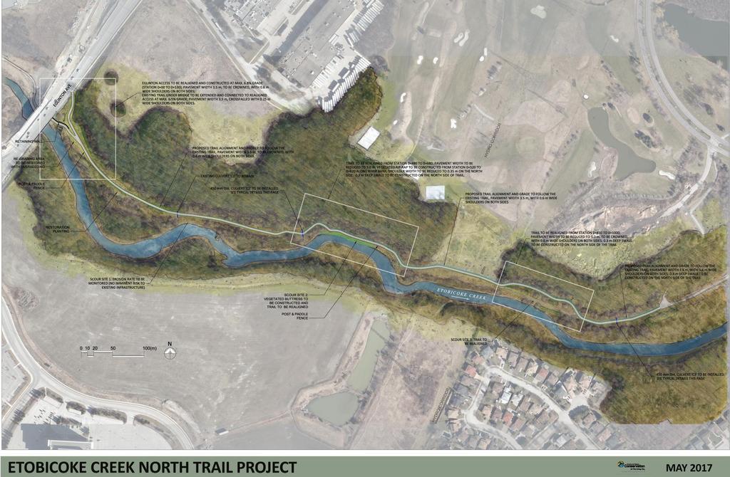
12 Roll Plan (on table) Trail Overview 12
13 Roll Plan (on table) Eglinton Access and Extension Drawing 13
14 Roll Plan (on table) Scour Site 2 Buttress and Trail Realignment 14
15 Roll Plan (on table) Scour Site 3 Trail Realignment 15

16 Vegetated Rock Buttress 16

17 Typical Trail Cross-Section 17

18 Design Considerations for the Natural Environment Minimize tree removals with expertise from certified arborist o Proposed trail to follow existing alignment except for two sections that will be realigned o Realigned sections of trail to be reduced from 3.5 m to 3.0 m wide and shoulders to be reduced from 0.6 m to 0.35 m wide Minimize aquatic habitat disturbance by reducing amount of in-stream work o Monitoring stations deployed to assess future creek migration rates at Scour Sites 1 and 3 18


19 Phase 1: Site Setup & Tree Removals Duration: ~ 50 days Fast Fence Silt Sock Sediment Filtration Bag Cofferdam Staging/Stockpiling Staging/Stockpiling 19
20 Site Setup Site Setup Aspects Fast Fence Description Temporary fencing will be erected along the access route and trail during construction to provide site security and ensure public safety Erosion and Sediment Control (ESC) Cofferdams Sediment Filtration Bag Staging & Stockpiling Areas Silt socks and sediment fencing will be placed along access routes and staging/stockpiling areas to prevent sediment from infiltrating the watercourse during construction A cofferdam consisting of pea-gravel meter bags will be placed in the creek to isolate the work area and prevent sediment from infiltration the watercourse Water will be pumped from the isolated work area and filtered through a filtration bag that is surrounded by erosion and sediment control measures prior to re-entering the watercourse Pre-determined areas where construction materials will be stored (surrounded by appropriate ESC measures) 20


")

21 Phase 2: Vegetated Rock Buttress Construction Duration: ~ 50 days Erosion Scour: Vegetated Buttress Location (Before) Excavation Installation Vegetated Buttress Location (After) 21


22 Phase 3: Trail Construction Duration: ~100 days Excavation with tree protection Gravel/Stone Placement with ESC Final Asphalt Paving/Site Restoration 22


23 Tree Protection Measures and Site Restoration Qualified arborist to conduct regular site inspections to ensure all tree protection measures are in proper working order and negative impacts to trees are kept to a minimum Drainage swale to be field-fitted and hand dug around large tree roots (where possible) Approximately 60 trees, including 14 non-native Manitoba Maple, and 4 invasive Buckthorn trees to be removed to facilitate construction of the proposed trail TRCA s typical compensation ratio of 3:1 (3 trees planted for each tree removed) to be exceeded with 267 native trees and 500 native shrubs proposed to be planted All disturbed areas to be restored to existing conditions or better using topsoil and native seed mix Tree protection measures (fast fence) 23
24 Restoration Plan 24
25 Next Steps Discuss your questions or concerns with City staff at this meeting Fill out a comment form, so we may consider your input. Comment forms may be dropped off with a staff person as you leave If you would like to submit your comment form at a later date, you may do so by or mail. Please submit your comment form by June 1, 2017 Construction of the trail is expected to start in June 2017, pending approvals, and a separate notice will be sent out prior to construction Construction and final site restoration are expected to be finalized by spring 2018, as weather conditions permit The public can stay informed by requesting to be added to the project mailing list and through the project webpage, For more information about this project please contact: Paul Martin Public Consultation Unit City of Toronto, Metro Hall, 19 th Floor 55 John Street, Toronto, ON M5V 3C6 paul.martin@toronto.ca Phone:
Update Report - Etobicoke Creek and South Mimico Creek Trails
 REPORT FOR ACTION Update Report - Etobicoke Creek and South Mimico Creek Trails Date: October 23, 2017 To: Etobicoke York Community Council From: General Manager, Parks Forestry and Recreation Wards: Ward
FINCH HYDRO CORRIDOR TRAIL PROJECT
 FINCH HYDRO CORRIDOR TRAIL PROJECT Pharmacy Avenue to Birchmount Road January 29 th, 2018 L Amoreaux Community Centre (2000 McNicoll Avenue) 1 Purpose of Drop In Event The purpose of today s drop-in event
EAST DON TRAIL ENVIRONMENTAL ASSESSMENT. Community Liaison Committee Meeting #3 July 15, :30 to 8:30 pm Flemingdon Park Library
 EAST DON TRAIL ENVIRONMENTAL ASSESSMENT Community Liaison Committee Meeting #3 July 15, 2013 6:30 to 8:30 pm Flemingdon Park Library Agenda 1. Welcome 2. Housekeeping and Updates a) Housekeeping b) CLC
Finn Creek Park. Management Direction Statement Amendment
 Finn Creek Park Management Direction Statement Amendment November 2013 Management Direction Statement Amendment Approved by: Jeff Leahy Regional Director, Thompson Cariboo BC Parks November 12, 2013 Date
Committee. Presentation Outline
 CW-33-15 11/9/2015 Community and Corporate Services Committee November 10, 2015 1 Presentation Outline Background Vision and Objectives Study Process and Timeline Public and Stakeholder Engagement Organization
Trail # NW Tuesday, June DESIGN. Provide an Review the Provide an. Project Goals: System system. wayfinding
 I. Welcome / Introductions Bethany Creek Trail #2 Segment 3 Neighborhood Meeting #1 Bethany Presbyterian Church 15505 NW Springville Road, Portland, OR 97229 Tuesday, June 26, 2018 @ 6:00PM Meeting Minutes
2. STAKEHOLDER FEEDBACK // What We Heard
 1. QUARRY ROAD TRAIL // Welcome to the Information Session PROJECT DESCRIPTION WHY WE ARE HERE Quarry Road Trail is a popular commuter trail and recreational area for Calgarians. 1. To report citizen feedback
BOULDER CREEK CATTLE FENCING FOR KOKANEE HABITAT ENHANCEMENT 2010
 BOULDER CREEK CATTLE FENCING FOR KOKANEE HABITAT ENHANCEMENT 2010 Prepared for the: FISH & WILDLIFE COMPENSATION PROGRAM, NELSON, B.C. Prepared by: Marc André Beaucher CRESTON VALLEY WILDLIFE MANAGEMENT
Chorley Park Trail Connection New Design Options. Information Booklet Prepared for June 9, 2014 Public Meeting
 Chorley Park Trail Connection New Design Options Information Booklet Prepared for June 9, 2014 Public Meeting Chorley Park Trail Booklet June 9, 2014 Page 1 of 12 Our Goals for the Chorley Park Trail Connection
FEASIBILITY CRITERIA
 This chapter describes the methodology and criteria used to evaluate the feasibility of developing trails throughout the study areas. Land availability, habitat sensitivity, roadway crossings and on-street
Wallace Falls State Park Classification and Management Planning Stage 3 Preliminary Recommendations July 18, 2018 Sultan City Hall
 Wallace Falls State Park Classification and Management Planning Stage 3 Preliminary Recommendations July 18, 2018 Sultan City Hall Thanks for coming! This document contains State Parks preliminary recommendations
ROAD AND TRAIL PROJECT APPROVAL
 ROAD AND TRAIL PROJECT APPROVAL www.marincountyparks.org Marin County Parks, 3501 Civic Center Dr, Suite 260, San Rafael, CA 94903 DATE: July 12, 2017 PRESERVE: Gary Giacomini Open Space Preserve PROJECT:
Daisy Dean Trail 628/619 ATV Trail Construction
 Background and Purpose and Need The Daisy Dean ATV Trail Construction Project is located in the Little Belt Mountains, Musselshell Ranger District, Lewis and Clark National Forest approximately 32 miles
Understanding user expectations And planning for long term sustainability 1
 Understanding user expectations And planning for long term sustainability 1 What is a natural surface trail? It can be as simple has a mineral soil, mulched or graveled pathway, or as developed as elevated
Establishing a National Urban Park in the Rouge Valley
 STAFF REPORT ACTION REQUIRED Establishing a National Urban Park in the Rouge Valley Date: March 29, 2012 To: From: Wards: Reference Number: Executive Committee Deputy City Manager, Cluster B All p:\2012\cluster
Brampton, Ontario REQ. no.: PLANNING, DESIGN & DEVELOPMENT COMMITTEE
 ftorontoand REGION rv~ Conservation for The Living City May 22,2009 2I22V,5L CFN 42397 CLERK S DEPT. Mr. Peter Fay City Clerk, City of Brampton MAY 2 7 2008 2 Wellington Street West Brampton, Ontario REQ.
Cultural Resource Management Report Deer Valley 4wd Restoration and Blue Lakes Road Maintenance Project R
 Cultural Resource Management Report R2015-05-03-10005 Undertaking Description: The proposes to perform road maintenance and meadow restoration on the Deer Valley 4wd trail and road maintenance on the Blue
LESLIE BARNS & CONNECTION TRACK. Project Update Construction and Traffic Management Consultation
 LESLIE BARNS & CONNECTION TRACK Project Update Construction and Traffic Management Consultation PRESENTATION SUMMARY Part 1 Brief Project Update (New Streetcars & Streetscape Improvements) Part 2 Construction
The Chu property is a 6.57 acre parcel located in the Town of Superior on the west side of McCaslin Boulevard. In 2014, the Town of Superior acquired
 1 The Chu property is a 6.57 acre parcel located in the Town of Superior on the west side of McCaslin Boulevard. In 2014, the Town of Superior acquired the Chu property for open space with a contribution
Presentation Overview
 DON NARROWS Historical and Existing Conditions March 29, 2008 Presentation Overview 1. Project Location and Background 2. Historical Context How did the Don Narrows Come to Be? 3. The Today 4. Next Steps
Longmont to Boulder Regional Trail Jay Road Connection DRAFT FINAL REPORT
 Longmont to Boulder Regional Trail Jay Road Connection DRAFT FINAL REPORT December 2018 Project Summary Boulder County, Colorado, in partnership with the City of Boulder, is evaluating options for multi-use
APPENDIX F List of Commitments
 APPENDIX F List of Commitments s Table F.1 Standard Mitigation Measures Mitigation Measure MnDOT Specification Number Status Update Description Status Update Utilities Provide early notice to utility operators
Lake Manitoba Lake St. Martin
 Lake Manitoba Lake St. Martin Outlet Channels Public Information Session June 29, 2017 July 13, 2017 Background & History 2011 Spring Flood Event High flows recorded on most streams and rivers in the Assiniboine
Fossil Creek Wild & Scenic River Comprehensive River Management Plan Forest Service Proposed Action - details March 28, 2011
 Fossil Creek Wild & Scenic River Comprehensive River Management Plan Forest Service Proposed Action - details March 28, 2011 Primary Goals of the Proposed Action 1. Maintain or enhance ORVs primarily by
Auburn Trail / Ontario Pathways Trail Connector Feasibility Study Public Information Meeting Wednesday, August 22, 2012
 Auburn Trail / Ontario Pathways Trail Connector Feasibility Study Public Information Meeting Wednesday, August 22, 2012 Purpose of Feasibility Study Purpose Evaluate the feasibility of constructing a multiuse
City of Durango 5.8 FUNDING TRAILS DEVELOPMENT
 5.8 FUNDING TRAILS DEVELOPMENT The City has been successful in establishing dedicated local funding sources as well as applying for grants to develop the City s trail system, having received nearly $2.4
Public Notice ISSUED: December 10, 2018 EXPIRES: January 9, 2019
 APPLICANT: REFER TO: St. Louis and Lake Counties Regional Rail Authority 2018-01942-ARC Public Notice ISSUED: December 10, 2018 EXPIRES: January 9, 2019 SECTION:404 - Clean Water Act 1. APPLICATION FOR
Strengthening the Ontario Trails Strategy. Report on Consultations and the Environmental Bill of Rights Registry
 Strengthening the Ontario Trails Strategy Report on Consultations and the Environmental Bill of Rights Registry Purpose To report on the feedback and information received through the regional consultations,
Triangle Land Conservancy Conservation Area Monitoring Report Carolina North
 Triangle Land Conservancy Conservation Area Monitoring Report Carolina North Property Name: Bolin Creek West Conservation Area Date of visit: March 16, 2017 County: Orange Property Type: Restrictive Covenants
CREATING CONNECTIONS IN THE CITY OF NIAGARA FALLS PUBLIC MEETING DECEMBER 6, 2017
 CREATING CONNECTIONS IN THE CITY OF NIAGARA FALLS PUBLIC MEETING DECEMBER 6, 2017 CONGESTION COSTS OUR ECONOMY The average commute in Ontario is already over 45 minutes, and that figure jumps to more than
Rule Governing the Designation and Establishment of All-Terrain Vehicle Use Trails on State Land
 Rule Governing the Designation and Establishment of All-Terrain Vehicle Use Trails on State Land 1.0 Authority 1.1 This rule is promulgated pursuant to 23 V.S.A. 3506. Section 3506 (b)(4) states that an
Stephanie Sinnott, Executive Director, Finance, Office of the City Manager
 Public Report To: From: Finance Committee Stephanie Sinnott, Executive Director, Finance, Office of the City Manager Paul D. Ralph, BES, RPP, MCIP, Commissioner, Development Services Department Report
THAT the Board approve the final proposed concept plan for the Jericho Marginal Wharf site as shown in Figure C-4 of Appendix C.
 Date: January 17, 2012 TO: Board Members Vancouver Park Board FROM: General Manager Parks and Recreation SUBJECT: Jericho Marginal Wharf Phase 2 Concept Plan RECOMMENDATION THAT the Board approve the final
 March 25, 1994 To: Re: MEMO TO FILE MINOR AMENDMENT - PINERY PROVINCIAL PARK MANAGEMENT PLAN The following paragraph from page 5 of the Pinery Provincial Park Management Plan (ISBN 0-7729-0290-9) lnsects
MORGAN CREEK GREENWAY Final Report APPENDICES
 APPENDICES MORGAN CREEK GREENWAY Appendix A Photos of Existing Conditions in Trail Corridor Photos of existing conditions Main trail corridor - February 2009 Photos of existing conditions south bank Morgan
Metrolinx Projects: Temporary Delegation for Long- Term Road Closures
 PW29.1 REPORT FOR ACTION Metrolinx Projects: Temporary Delegation for Long- Term Road Closures Date: April 24th, 2018 To: Public Works and Infrastructure Committee From: General Manager, Transportation
Appendix A Appendix A (Project Specifications) Auk Auk / Black Diamond (Trail 44) Reroute
 Auk Auk / Black Diamond (Trail 44) Reroute") Appendix A (Project Specifications) Auk Auk / Black Diamond (Trail 44) Reroute I. Proposed Action: This project proposes to reroute approximately 1,800 feet of a 50 inch wide trail, off of private property
Appendix A (Project Specifications) Auk Auk / Black Diamond (Trail 44) Reroute I. Proposed Action: This project proposes to reroute approximately 1,800 feet of a 50 inch wide trail, off of private property
CONTENTS. 1 Introduction Always Moving Forward while Building on the Past A Dynamic Destination... 5
 2010 STRUCTURE PLAN - 2 - CONTENTS 1 Introduction... 5 1.1 Always Moving Forward while Building on the Past... 5 1.2 A Dynamic Destination... 5 2 Map A... 6 Exhibition Place and its Neighbours... 7 3 Demonstration
COMMUNITY MEETING NOVEMBER 1, Wheaton Regional Park Pine Lake Trail
 COMMUNITY MEETING NOVEMBER 1, 2012 MEETING AGENDA I. Introduction of Project Team II. Trail Renovation Process III. Wheaton Regional Park IV. Pine Lake Trail Renovation Project V. Comments and Questions
Understanding the caring capacity of the visitor experience Provide facilities to support a high level user experience Address visual quality through
 Understanding the caring capacity of the visitor experience Provide facilities to support a high level user experience Address visual quality through recreation ecological restoration opportunities Collaboration
National Forests and Grasslands in Texas
 United States Department of Agriculture Forest Service National Forests and Grasslands in Texas Sam Houston NF 394 FM 1375 West New Waverly, Texas 77358 Phone 936-344-6205 Dear Friends, File Code: 1950
China Creek North Park Upgrades and Glen Pump Station. Park Board Committee Meeting Monday, July 10, 2017
 China Creek North Park Upgrades and Glen Pump Station Park Board Committee Meeting Monday, July 10, 2017 Purpose The purpose of this presentation is to: Share the results of the public engagement processes;
FURTHER TO AUTHORITY MEETING #5/13 To Be Held June 21, 2013
 FURTHER TO AUTHORITY MEETING #5/13 To Be Held June 21, 2013 FURTHER TO: Pages AUTH7. SECTION I - ITEMS FOR AUTHORITY ACTION AUTH7.4 AUTH7.5 AUTH7.6 COATSWORTH CUT PROJECT Contract RSD13-080 - Channel Dredging
OPG, Nuclear 2
 B iodiversity Assessment Building a Biodiversity Management Plan November 24, 2011 OPG, Nuclear 2 Biodiversity Assessment What habitat, or your site? potential habitat, is available on What species of
Trail Feasibility Study
 VOLUSIA COUNTY MPO CITY OF NEW SMYRNA BEACH FINAL REPORT JUNE 30, 2009 Trail Feasibility Study What s inside? 1 Introduction 2 Project Purpose & Scope 3 Physical Inventory & Assessment of Right-of- Way
INTRODUCTION. Mailing address: Burke County Community Development Attn: Tim Johnson P. O. Box 219 Morganton, NC
 REQUEST FOR QUALIFICATIONS: PROFESSIONAL, EXPERIENCED TRAIL BUILDERS FOR THE CONSTRUCTION OF THE FONTA FLORA STATE TRAIL LAKE JAMES SECTION BURKE COUNTY COMMUNITY DEVELOPMENT INTRODUCTION Burke County
Coastal Gas Link Project of Trans Canada Pipelines. Community Profile of Stellat en First Nation
 Coastal Gas Link Project of Trans Canada Pipelines Community Profile of Stellat en First Nation What is the Coastal Gas Link Project? Trans Canada Pipeline is planning to build a 650 Km. natural gas pipeline
Taylor Creek Park Management Plan Online Engagement - Summary
 Objectives of Online Engagement Taylor Creek Park Management Plan Online Engagement - Summary Spread awareness of the creation of the Taylor Creek Park Management Plan. Provide an overview of the project.
CHAPTER III: TRAIL DESIGN STANDARDS, SPECIFICATIONS & PERMITS
 CHAPTER III Trail Design Standards, Specifications & Permits This chapter discusses trail standards, preferred surface types for different activities, permits, and other requirements one must consider
CITY COUNCIL AGENDA MEMORANDUM
 To: Mayor and City Council From: Charles Ozaki, City and County Manager Prepared By: Kevin Standbridge, Deputy City and County Manager Katie Allen, City and County Engineer David Shinneman, Community Development
Appendix 1: Best Management Practices For Hang Gliding and Paragliding in Jasper National Parks
 Appendix 1: Best Management Practices For Hang Gliding and Paragliding in Jasper National Parks Name of Best Management Practice Best Management Practices for Hang Gliding and Paragliding in Jasper National
Request for Proposal National Tropical Botanical Garden Lower Limahuli Preserve Emergency Stream Debris Removal
 Request for Proposal National Tropical Botanical Garden Lower Limahuli Preserve Emergency Stream Debris Removal I. Summary of Work Bids are solicited for the emergency removal of debris deposited in the
Business Item No XXX. Proposed Action That the Metropolitan Council approve the Coon Creek Regional Trail Master Plan.
 Business Item No. 2015-XXX Metropolitan Parks and Open Space Commission Meeting date: July 7, 2015 For the Community Development Committee meeting of July 20, 2015 For the Metropolitan Council meeting
2016 Regional Transportation Alternatives Program (TAP) Grant Application
 Grant Application") 2016 Regional Transportation Alternatives Program (TAP) Grant Application PROJECT TITLE: Yelm-Tenino Trail Extension Feasibility Study TRPC use only GENERAL PROJECT INFORMATION Agency or Organization City
2016 Regional Transportation Alternatives Program (TAP) Grant Application PROJECT TITLE: Yelm-Tenino Trail Extension Feasibility Study TRPC use only GENERAL PROJECT INFORMATION Agency or Organization City
Bear Creek Habitat Improvement Project
 06/10/10 Bear Creek Habitat Improvement Project El Paso County, Colorado Pike National Forest and Colorado Springs Utilities Owned Land Report prepared by: Eric Billmeyer Executive Director Rocky Mountain
SAMSON CREE NATION MATRIX SOLUTIONS INC. PARTNERSHIP ABORIGINAL CONSTRUCTION MONITORING
 SAMSON CREE NATION MATRIX SOLUTIONS INC. PARTNERSHIP ABORIGINAL CONSTRUCTION MONITORING WEEKLY REPORT SPREAD 2 AUGUST 20 TH - AUGUST 25 TH Suite 600, 214-11 Ave. SW Calgary, AB, Canada T2R 0K1 T 403.237.0606
Mt. Hood National Forest
 United States Department of Agriculture Forest Service Mt. Hood National Forest Zigzag Ranger District 70220 E. Highway 26 Zigzag, OR 97049 503-622-3191 Fax: 503-622-5622 File Code: 1950-1 Date: June 29,
Citrus Heights Creek Corridor Trail Project Trail Advisory Group Field Trip #2 September 11, :00 11:00 am Trellis Hall, Citrus Heights
 September 11, 2013 9:00 11:00 am Trellis Hall, Citrus Heights Project Overview The City of Citrus Heights is studying the feasibility of establishing a multi use trail system within the City s 26 miles
Yard Creek Provincial Park. Management Plan
 Yard Creek Provincial Park Management Plan Draft January 2010 Yard Creek Provincial Park Management Plan Approved by: telàlsemkin/siyam/chief Scott Benton Bill Williams Squamish Executive Director ation
Attendance Presentation
 TO The Community of Saanich FROM District of Saanich DATE January 30, 2017 RE Meeting Notes Haro Woods Jan 28th Community Engagement Goward House, 2495 Arbutus Road, Victoria BC Attendance In total, 18
SAMSON CREE NATION MATRIX SOLUTIONS INC. PARTNERSHIP ABORIGINAL CONSTRUCTION MONITORING
 SAMSON CREE NATION MATRIX SOLUTIONS INC. PARTNERSHIP ABORIGINAL CONSTRUCTION MONITORING WEEKLY REPORT SPREAD 2 AUGUST 13 TH - AUGUST 18 TH Suite 600, 214-11 Ave. SW Calgary, AB, Canada T2R 0K1 T 403.237.0606
Welcome to the future of Terwillegar Park a Unique Natural Park
 Welcome to the future of Terwillegar Park a Unique Natural Park 1 Introduction The Terwillegar Park Concept Plan study will develop an overall concept plan, management objectives and development guidelines
AGAWAM CONSERVATION COMMISSION April 26, 2018
 MEMBERS PRESENT: Henry A. Kozloski, Chairman Sheryl Becker S. Page Fallon Frank Meagher MEMBERS ABSENT: Magda Galiatsos Jill Messick ALSO PRESENT: Pamela R. Kerr AGAWAM CONSERVATION COMMISSION Mr. Kozloski
Business Item No
 Metropolitan Parks and Open Space Commission Meeting date: February 6, 2018 For the Community Development Committee meeting of February 20, 2018 For the Metropolitan Council meeting of February 28, 2018
Triangle Land Conservancy Conservation Area Monitoring Report Carolina North
 Triangle Land Conservancy Conservation Area Monitoring Report Carolina North Property Name: Bolin Creek East Conservation Area Date of visit: March 16, 2017 County: Orange Property Type: Restrictive Covenants
Preferred Recreation Recommendations Stemilt-Squilchuck Recreation Plan March 2018
 Preferred Recreation Recommendations Stemilt-Squilchuck Recreation Plan March 2018 Below are the recommended recreation ideas and strategies that package together the various recreation concepts compiled
APPENDIX 3-I-B. Alternative Route Assessment Around Provincial Parks and Conservation Reserves
 EAST-WEST TIE TRANSMISSION PROJECT ENVIRONMENTAL ASSESSMENT REPORT APPENDIX 3-I-B Alternative Route Assessment Around Provincial Parks and Conservation Reserves Report No. 1536607/2000/2018 TABLE OF CONTENTS
KP Lasnaya 1 River
 KP 370.2 Lasnaya 1 River The Lasnaya 1 River crossing is protected by Reno mattings and a gabion wall on the north bank (Photo 1). The south bank consists of natural river gravel deposits on top of Reno
Welcome to the Cross County Trail Public Input Session!
 Welcome to the Cross County Trail Public Input Session! Please sign in on the table below! What are we doing here? Camden County has proposed a bicycle and pedestrian trail spanning across the entire county.
Committee Report. Community Development Committee For the Metropolitan Council meeting of August 12, Business Item No.
 Committee Report Business Item No. 2015-168 Community Development Committee For the Metropolitan Council meeting of August 12, 2015 Subject: Coon Creek Regional Trail Master Plan, Anoka County Proposed
Coronado National Forest Santa Catalina Ranger District
 United States Department of Agriculture Forest Service Coronado National Forest Santa Catalina Ranger District File Code: 1950 Date: October 14, 2015 Dear Interested Party: The Santa Catalina Ranger District
Land Management Summary
 photo credit: ANGAIR Anglesea Heath Land Management Summary The Anglesea Heath (6,501 ha) was incorporated into the Great Otway National Park in January 2018. This provides an opportunity to consider the
Thank you for joining us to learn about and provide input on the Highbury Interceptor Air Management Facility in Musqueam Park.
 1 WELCOME Thank you for joining us to learn about and provide input on the Highbury Interceptor Air Management Facility in Musqueam Park. 6:00-6:30 p.m. Open House 6:30-7:30 p.m. Presentation and Q&A 7:30-8:00
Appendix 3. Greenway Design Standards. The Whitemarsh Township Greenway Plan
 Appendix 3 Greenway Design Standards This chapter discusses two design standards for the greenway types discussed above. First, trail design standards are presented together with trailhead facilities and
Prepared by Cathy Quinlan & Brad Hertner Upper Thames River Conservation Authority. For the City of Woodstock
 Prepared by Cathy Quinlan & Brad Hertner Upper Thames River Conservation Authority For the City of Woodstock Burgess Park and Standard Tube Parks in the west end of Woodstock Pittock Reservoir Along the
Macleod Trail Corridor Study. Welcome. Macleod Trail Corridor Study Open House. Presentation of Proposed Design Concepts
 Macleod Trail Corridor Study Welcome Macleod Trail Corridor Study Open House Presentation of Proposed Design Concepts Study Purpose Develop a corridor plan for Macleod Trail that aligns with The City s:
3.0 EXISTING PARK & RECREATION SPACE
 3.0 EXISTING PARK & RECREATION SPACE TOWN PARK & RECREATION SPACE An inventory of current parks and recreation area in the Town of Cedarburg is shown in Table 3. These areas total roughly 381.89 acres.
Port Gamble Shoreline Area Conceptual Trail Proposal
 The North Kitsap Trails Association is pleased to be a partner to the Kitsap Forest and Bay Project and assist Kitsap County, Forterra, Olympic Property Group, Great Peninsula Conservancy and the Port
Engagement Summary Report. Trans-Canada Highway 1 RW Bruhn Bridge Replacement Project. Community Engagement November 15, 2016 to January 15, 2017
 Trans-Canada Highway 1 RW Bruhn Bridge Replacement Project Community Engagement November 15, 2016 to January 15, 2017 Engagement Summary Report February 2017 Prepared by Kirk & Co. Consulting Ltd. Trans-Canada
DIXIE HIGHWAY Region of Peel NAI Area # 1304, 1320, 2449, 2625, 3961
 DIXIE HIGHWAY 407 1 Region of Peel NAI Area # 1304, 1320, 2449, 2625, 3961 Toronto and Region Conservation Authority City of Brampton Size: 36 hectares Watershed: Etobicoke Creek Con 4 E, Lots 13, 14 Ownership:
Chuckanut Ridge Fairhaven Highlands EIS Scoping Concerns
 Chuckanut Ridge Fairhaven Highlands EIS Scoping Concerns Coalition of Southside Neighborhoods CSN Comments for Fairhaven Highlands EIS Scope Hearing, Jan 16, 2008 1 Chuckanut Ridge Hilly Terrain: Potential
Classifications, Inventory and Level of Service
 Classifications, Inventory and Level of Service Section 3 Kenmore Park, Recreation and Open Space Plan 1 P a g e Classifications and Inventory Park Classifications Kenmore classifies its parks based upon
Advisory Circular CT
 (CAA logo, name of the country, etc.) Advisory Circular CT-42-009 SUBJECT: Airport Movement Area and Related Facilities Maintenance DATE: MM/YYYY ASSOCIATED RULES According with (name of the country) Civil
2018 Goldwedge Mines Inc. Licence of Occupation Management Plan. Photo: xxxx. Goldwedge Mines Inc.
 2018 2018 Goldwedge Mines Inc. Licence of Occupation Management Plan Photo: xxxx Goldwedge Mines Inc. March 2018 TABLE OF CONTENTS TABLE OF CONTENTS... i Figures... i 1. Background... 2 Project Overview...
Decision Memo for Desolation Trail: Mill D to Desolation Lake Trail Relocation
 for Salt Lake County, Utah Uinta-Wasatch-Cache National Forest Salt Lake Ranger District 1. Background The present location of the Desolation Trail (#1159) between Mill D and Desolation Lake follows old
SAMSON CREE NATION MATRIX SOLUTIONS INC. PARTNERSHIP ABORIGINAL CONSTRUCTION MONITORING
 SAMSON CREE NATION MATRIX SOLUTIONS INC. PARTNERSHIP ABORIGINAL CONSTRUCTION MONITORING WEEKLY REPORT SPREAD 2 SEPTEMBER 4 TH - SEPTEMBER 8 T H Suite 600, 214-11 Ave. SW Calgary, AB, Canada T2R 0K1 T 403.237.0606
Members of the Administrative Staff Committee. Award of Tender T Trans Canada Trail Extension
 To: From: Members of the Administrative Staff Committee W.H. Jackson, Director of Utility Services Meeting Date: August 26, 2015 Subject: Report USEC15-021 Award of Tender T-54-15 - Trans Canada Trail
Clam Harbour Provincial Park
 Clam Harbour Provincial Park Public Engagement Session Thursday, September 14 th, 2017 5:30pm 7:30pm Webbers Store 11470 Nova Scotia Trunk 7 Lake Charlotte, NS Agenda Overview of the Provincial Parks System
3.0 LEARNING FROM CHATHAM-KENT S CITIZENS
 3.0 LEARNING FROM CHATHAM-KENT S CITIZENS An important aspect in developing the Chatham-Kent Trails Master Plan was to obtain input from stakeholders and the general public. Throughout the course of the
Cat Island Chain Background & Access Guide
 Cat Chain Background & Access Guide Brown County Port & Resource Recovery Department 2561 S. Broadway, Green Bay, WI 54304 (920) 492-4950 www.portofgreenbay.com January 2018 1 Restoration of the Cat Chain
1 PROJECT STATUS UPDATE 2 ND CONCESSION FROM BRISTOL ROAD TO DOANE ROAD TOWNS OF EAST GWILLIMBURY AND NEWMARKET
 Report No. 3 of the Regional Council Meeting of March 28, 2013 1 PROJECT STATUS UPDATE 2 ND CONCESSION FROM BRISTOL ROAD TO DOANE ROAD TOWNS OF EAST GWILLIMBURY AND NEWMARKET The recommends: 1. Receipt
Header i
 Header i 048285014.10 Header Sub Title Body Text here. Body text here. Body text here. Section 1... 1 Executive Summary... 1 Opportunities and Constraints... 3 Overall Opportunities and Constraints Map
The Baker/Carver Regional Trail is intended to
 Section V Design Guidance The Baker/Carver Regional Trail is intended to safely accommodate 183,000 annual visits, an array of non-motorized uses, a variety of skill levels, and persons with special needs.
Brooker Creek Preserve Management Plan 2008 Update
 Brooker Creek Preserve Management Plan 2008 Update Plan approved by the Board of County Commissioners Pinellas County, Florida 19 August 2008 Pinellas County Department of Environmental Management Environmental
Blue River Trail Master Plan JSA to Town Hall June 2004
 Blue River Trail Master Plan JSA to Town Hall June 2004 Prepared for: Silverthorne Town Council Silverthorne SPORT Committee Department of Recreation and Culture Silverthorne Public Works Silverthorne
Chair and Members, The Etobicoke York Community Council. Mark Sraga, Director and Deputy Chief Building Official
 STAFF REPORT ACTION REQUIRED Sign Variance Report - Revised 29 Algie Avenue Date: January 11, 2010 To: From: Chair and Members, The Etobicoke York Community Council Mark Sraga, Director and Deputy Chief
Dungeness Recreation Area County Park Master Plan
 Dungeness Recreation Area County Park Public Outreach Meeting October 10, 2007 Project Overview USFWS Site Dungeness Recreation Area County Park Meeting Objectives: Re-Introduce project; provide status
HIGHWAY 17 WILDLIFE and REGIONAL TRAIL CROSSINGS
 HIGHWAY 17 WILDLIFE and REGIONAL TRAIL CROSSINGS Agenda and Meeting Format 7:00-7:15 Welcome 7:15-8:00 Presentation 8:00-8:30 Open House 8:30 Recap 9:00 Conclusion 2 Meeting Goals: Introduce the project
First Steps Towards Sustainable Operation of Road Tunnels. George Mavroyeni Australia
 First Steps Towards Sustainable Operation of Road Tunnels George Mavroyeni Australia Road Tunnel Operations First steps towards sustainable operation of road tunnels Available on PIARC website here PIARC
B10. Agate Beach State Recreation Site
 B10. Agate Beach State Recreation Site Location Within the City of Newport, just south of the Yaquina Head Outstanding Natural Area. The park is located along the west side of Highway 101 at the mouth