Presentation Overview
|
|
|
- Isabel Cory Joseph
- 5 years ago
- Views:
Transcription


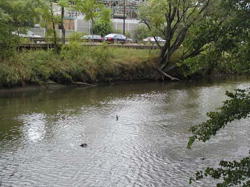
1 DON NARROWS Historical and Existing Conditions March 29, 2008 Presentation Overview 1. Project Location and Background 2. Historical Context How did the Don Narrows Come to Be? 3. The Today 4. Next Steps Where is the? Don Narrows What is the? The extends ~2150 metres from Riverdale Park to Lake Shore Blvd; where the Don River enters the Keating Channel. Engineering works in the late-1880s straightened and widened the river channel; cedar posts were inserted into the ground vertically side-by-side to create new river banks. Steel sheet-piles were installed behind these cedar posts in the late-1940s to mid-1950s to facilitate construction of the Don Valley Parkway (DVP) and Bayview extensions. Remnants of the original cedar posts can still be seen in the Narrows

, and straight, hard channel banks that are overly-wide inhibit the formation of good aquatic habitat within the Narrows.")
2 What is the Don Narrows? (continued) The location of the DVP, Bayview Avenue and railways along the top of the river bank through the Narrows are frequently flooded (~2 year return period). A pedestrian trail along the west side of the river provides the only public access to the Don River through the Narrows. Vegetation along the Narrows is either absent or limited to a narrow band of opportunistic trees, grasses and shrubs usually of the invasive variety. Heavy sediment loads (mainly sands and silts), and straight, hard channel banks that are overly-wide inhibit the formation of good aquatic habitat within the Narrows. Project Background For years, strong community support has been expressed to improve the natural habitat conditions along and within the. In response, TRCA and Waterfront Toronto included consideration of In- Channel naturalization opportunities for the Don Narrows as part of the DMNP EA Existing Conditions A Vision By the Task Force to Bring Back the Don (2001) Project Objective As part of the Step 5 Activities for the Don Mouth Naturalization and Port Lands Flood Protection Project EA, TRCA and the Gartner Lee Limited consultant team will examine opportunities for improving the instream habitat conditions within the Don Narrows (e.g., within the channel banks and immediately adjacent to the top of banks between the DVP on the east and railway tracks on the west). The EA team will examine: Options for providing instream structures designed to improve aquatic habitat quality; and Where vegetation can be planted or transplanted (in the case of phasing out invasive species). HOWEVER, THERE ARE SOME CONSTRAINTS! Naturalization cannot increase the frequency of flooding on the Don Valley Parkway (DVP), Bayview Avenue, nor the railway tracks on the west side of the river (which are currently flooded almost every year in sections); Naturalization features cannot increase water levels during the Regulatory Flood Event; Naturalization features cannot increase the risk of failure for transportation and utility infrastructure running parallel to the. Historical Context How did the end up this way?

.")


3 Front Street Vidal, 1815 Future Queen Street Early 1800s Early to mid 1800s, the Don River originally exited into the Ashbridge s Bay Marsh near what would become Eastern Avenue. Mid 1800s By 1857, the Grand Trunk Railroad had established a rail crossing over the Don between Palace Street and Front Street (adjacent to existing location). By late 1850 s, crossings at Gerrard Street (then known as Bell s Bridge) and Queen Street were built. Between late 1850 s and 1890, numerous other road bridges were built and either destroyed or removed south of Queen Street Late 1850 s small ships and scows travelled up and down the river as far as Gerrard. Chewett, 1866 Late 1800s Don River Improvements occurred between 1887 and 1890 Objectives were to straighten and deepen the channel from Gerrard Street to the Grand Trunk Railway crossing. Goals were to provide flood protection, prevent ice jams and attract industry. The Improvement project was one of Toronto s greatest political boondoggles in the late 19 th century as it accomplished none of the goals, and took far longer to construct and at a much higher cost. Skating on the Narrows Cedar Pile Bank Protection along the Narrows


4 Late 1800s & Early 1900s By 1890, the Canadian Pacific Railway built railway lines up the Don Valley along the west side of the Don River, occupying lands that were made available by the Don River Improvement project. By 1912, the Keating Channel was completed, which effectively diverted the Don River entirely to the west, into the Inner Harbour. Early 1900s Pollution in the Don River increased during the 19 th and early 20 th century due to agriculture, logging, milling, industrial and animal wastes, and human sewage. Pollution accumulated in the lower Don and Ashbridge s Bay Marsh contributing to disease outbreaks. The Toronto Harbour Commissioners devised the 1912 Waterfront Plan, calling for the transformation of Ashbridge s Bay Marsh into a port that provided industrial, commercial and park land uses. The Port Industrial District was completed between 1912 and Early 1900s Major ice jam floods occurred in the Don, in February of 1918 and In 1928, the Grand Trunk Railway over the Don River was raised 6 metres onto an earthen viaduct The DVP & Bayview Extension were built along the east and west banks of the Narrows, respectively in the mid-1950s. The Gardiner Expressway was completed by the early 1960s, providing an elevated expressway from the DVP to Toronto s downtown core. Metropolitan Toronto Map, 1960 Mid 1900s
 Bridge Gardiner Express Ramps Queen St. Eastern Ave.")
5 In 2002 Gerrard St. Riverdale Park DVP What are the Physical Conditions Today? Dundas St. Bayview Extension Bala Subdivision (CPR) Old Eastern Ave. CN (Grand Trunk) Bridge Gardiner Express Ramps Queen St. Eastern Ave. Flood Levels in the Narrows (2 Year Flood) Flood Levels in the Narrows (2 and 100 Year Flood)
 74 73.5 73 72.5 72 71.5 71 70.")
 Bed Profile of in 2003 with Typical Lake Ontario Waterlevels and Minimum")
 Height (m) 78 77 76 75 74 73 72 78 77 76 75 74 73 72 71 70 0 10 20 30 40 50 Width (m) 0 10 20 30 40 50 Width (m) Typical Channel")
6 Flood Levels in the Narrows 75 Bed Profile of as Surveyed in 2003 Channel Morphology (2, 100 Year, and Regulatory Flood) Elevation Above Sea Level (m) Minimum Waterlevel in Lake Ontario Mean Waterlevel - Lake Ontario Average Bed Slope of Approximately 0.09% Distance Upstream From Lakeshore Boulevard (m) Bed Profile of in 2003 with Typical Lake Ontario Waterlevels and Minimum Lake Ontario Water Levels (in 2003) included. Height (m) Height (m) Width (m) Width (m) Typical Channel Cross-Sections in the Remnants of original cedar piles from 1880s Don River Improvement Project Riverdale Park Section (2007) Riverdale Park Section (2007) Looking downstream at Riverdale Park Pedestrian Bridge and Gerrard St. Bridge


")
7 Riverdale Park Section (2007) Looking upstream from Gerrard St. Bridge Looking downstream from Riverdale Park Pedestrian Bridge at Gerrard St. Bridge Under Gerrard Street (2007) Looking upstream from Gerrard St. Bridge Looking downstream from Gerrard St. Bridge Under Gerrard Street (2007) Under Gerrard Street (2007)
 At")


")
8 DVP upstream from Queen St. Bridge At Queen Street (2004) At Queen Street (2007) Looking downstream from Queen St. Bridge At Queen Street (2007) Looking upstream at Eastern Ave. Bridge Remnants of Cedar Piles Under Queen Street Bridge At Eastern Avenue (2004)
 Looking downstream")


9 At Eastern Avenue (2004) At Eastern Avenue (2003) Looking downstream from Eastern Ave. Bridge Looking downstream from Old Eastern Ave. Bridge At CN Railway Crossing (2005) Looking upstream from CN Railway Crossing At CN Railway Crossing (2007) Looking upstream at CN Railway Crossing


 Bala Pedestrian/Cyclist Underpass")

10 Looking downstream from Underneath CN Railway Crossing CN Railway Crossing (2007) Looking upstream prior to completion of bridge widening construction At CN Railway Crossing (2007) Bala Pedestrian/Cyclist Underpass West Don Lands Flood Protection Landform & Don River Park West Don Lands Other Works Adjacent to Other Works Adjacent to


11 Other Works Adjacent to Other Works Adjacent to Don Landing West Don Lands Possible Enbridge Utility Bridge Modifications Next Steps A Site Walk and Working Session to Discuss Ideas for the Naturalization of the will be held on Saturday May 24, 2008 IF INTERESTED IN PARTICIPATING, PLEASE PROVIDE YOUR NAME AND ADDRESS AT THE BOOTH SO THAT DETAILS OF THE EVENT CAN BE SENT TO YOU WHEN THEY ARE AVAILABLE
Union Station Rail Corridor East Enhancements Project
 Union Station Rail Corridor East Enhancements Project Transit Project Assessment Process Public Meeting #1 Presentation Wednesday June 28, 2017 GRIDLOCK COSTS OUR ECONONY REGIONAL TRANSFORMATION GO EXPANSION
Appendix B Connecting Track Options Evaluation Criteria
 Appendix B Connecting Track Options Evaluation Criteria 608979-853_ra_July5-0_App Title Pages.Docx TTC ASHBRIDGES BAY MAINTENANCE AND STORAGE FACILITY CONNECTING TRACK ROUTE ALTERNATIVE - EVAULATION MATRIX.0
STITCH TRANSFORMATIVE IDEA 3. SHORELINE STITCH. Re-connect the city to the waterfront and link the east and west Core Circle landscapes
 SHORE STITCH TRANSFORMATIVE IDEA 3. SHORELINE STITCH Re-connect the city to the waterfront and link the east and west Core Circle landscapes 126 LINE PUBLIC WORK 127 TRANSFORMATIVE IDEA 3. SHORELINE STITCH
ETOBICOKE CREEK NORTH TRAIL PROJECT. May 18, 2017 at Michael Power High School 105 Eringate Drive, Etobicoke ON M9C 3Z7
 ETOBICOKE CREEK NORTH TRAIL PROJECT May 18, 2017 at Michael Power High School 105 Eringate Drive, Etobicoke ON M9C 3Z7 1 Purpose of Open House The purpose of today s open house is to present the design
Union Station Rail Corridor East
 Union Station Rail Corridor East Community Advisory Committee CAC Meeting #2: Overview of Track Expansion Plans March 6, 2018 PURPOSE OF CAC MEETING #2 Future service requirements Infrastructure needed
Appendix C. Cultural Heritage Properties
 Appendix C Cultural Heritage Properties Existing Conditions Report Page 1 Don River Mouth Naturalization and Port Lands Flood Protection Project Appendix C: Inventory of Cultural Heritage Properties in
Appendix B. Cultural Heritage Properties
 Appendix B Cultural Heritage Properties Existing Conditions Report Page 1 1. CHL Industrial Port Lands Industrial District. Bounded by Lake Shore Boulevard on the north, Leslie Street on the east, Inner
Update Report - Etobicoke Creek and South Mimico Creek Trails
 REPORT FOR ACTION Update Report - Etobicoke Creek and South Mimico Creek Trails Date: October 23, 2017 To: Etobicoke York Community Council From: General Manager, Parks Forestry and Recreation Wards: Ward
Proposed Bicycle Lanes on Yonge Street from Queens Quay to Front Street
 STAFF REPORT ACTION REQUIRED Proposed Bicycle Lanes on Yonge Street from Queens Quay to Front Street Date: March 12, 2007 To: From: Toronto and East York Community Council Director, Transportation Infrastructure
Parking Amendments - Bay Street, between Harbour Street and Queens Quay West (York Street, Bay Street, and Yonge Street Ramp Removal)
") REPORT FOR ACTION between Harbour Street and Queens Quay West (York Street, Bay Street, and Yonge Street Ramp Removal) Date: October 26, 2017 To: Toronto and East York Community Council From: Acting Director,
REPORT FOR ACTION between Harbour Street and Queens Quay West (York Street, Bay Street, and Yonge Street Ramp Removal) Date: October 26, 2017 To: Toronto and East York Community Council From: Acting Director,
Pedestrian Safety Review Spadina Avenue
 STAFF REPORT ACTION REQUIRED Pedestrian Safety Review Spadina Avenue Date: October 13, 2015 To: Toronto and East York Community Council From: Director, Transportation Services, Toronto and East York District
Project Management, Environmental Assessment, Stormwater Management. Hydrologic Modelling. Natural Heritage. Fluvial Geomorphology
 Welcome PUBLIC INFORMATION CENTRE # 1 KROSNO CREEK DIVERSION PROJECT February 19, 2014 6:30 p.m. to 8:30 p.m. Please sign in on the sheet provided. Then feel free to walk around and view the displays.
Don Mouth Naturalization & Port Lands Flood Protection Project Environmental Assessment
 Don Mouth Naturalization & Port Lands Flood Protection Project Environmental Assessment Site Walk #2 and Boat Cruise Summary Notes October 14, 2006 Don Mouth Naturalization and Port Lands Flood Protection
Welcome KROSNO CREEK DIVERSION PROJECT CLASS ENVIRONMENTAL ASSESSMENT
 Welcome KROSNO CREEK DIVERSION PROJECT PUBLIC INFORMATION CENTRE # 1 Tonight s Presentation Study Overview Background Existing Conditions Alternative Solutions Preliminary Preferred Solution Next Steps
SAN ANTONIO RIVER IMPROVEMENTS PROJECT. April 27, 2009
 SAN ANTONIO RIVER IMPROVEMENTS PROJECT April 27, 2009 1 Project Limits 2 Project Partners City of San Antonio Provides project funding for project amenities (i.e.. Sidewalks, Landscaping, Lighting, etc.)
Building the transportation network we need for the future in Niagara Region
 Building the transportation network we need for the future in Niagara Region Niagara@metrolinx.com Metrolinx.com/Niagara Metrolinxengage.com INSERT FOOTER 1 WHO IS METROLINX? Metrolinx was created in 2006
SOUTHBOUND YONGE STREET TO EASTBOUND HIGHWAY 401 F L Y -UNDER
 SOUTHBOUND YONGE STREET TO EASTBOUND HIGHWAY 401 F L Y -UNDER Proposal to Eliminate Traffic Gridlock in South North York Centre Area With Southbound Yonge Street to Eastbound Highway 401 Fly-UNDER A much
EAST DON TRAIL ENVIRONMENTAL ASSESSMENT. Community Liaison Committee Meeting #3 July 15, :30 to 8:30 pm Flemingdon Park Library
 EAST DON TRAIL ENVIRONMENTAL ASSESSMENT Community Liaison Committee Meeting #3 July 15, 2013 6:30 to 8:30 pm Flemingdon Park Library Agenda 1. Welcome 2. Housekeeping and Updates a) Housekeeping b) CLC
Redesigning The Waterfront
 San Francisco Maritime National Park Service U.S. Department of the Interior National Historical Park California Redesigning The Waterfront A Self-Guided Walking Tour Then & Black Point Cove, ca. 1910.
FORT YORK PEDESTRIAN & CYCLE BRIDGE
 FORT YORK PEDESTRIAN & CYCLE BRIDGE November 2006 urban design landscape architecture architecture DTAH This is a new concept for the Fort York Pedestrian and Cycle Bridge linking Stanley Park (South)
CREATING CONNECTIONS IN THE CITY OF NIAGARA FALLS
 CREATING CONNECTIONS IN THE CITY OF NIAGARA FALLS LEON STAMBOLICH, DIRECTOR, CORRIDOR INFRASTRUCTURE ERIN MOROZ, DIRECTOR, COMMUNICATIONS AND COMMUNITY RELATIONS NIAGARA FALLS CITY COUNCIL NOVEMBER 28,
LESLIE BARNS & CONNECTION TRACK. Leslieville BIA Meeting May 2, 2014
 LESLIE BARNS & CONNECTION TRACK Leslieville BIA Meeting May 2, 2014 1 OVERVIEW Communications Queen/Leslie Intersection Closure Overview Next Steps - Coordination of TTC Track Upgrades (Queen streetcar
LESLIE BARNS & CONNECTION TRACK. Project Update Construction and Traffic Management Consultation
 LESLIE BARNS & CONNECTION TRACK Project Update Construction and Traffic Management Consultation PRESENTATION SUMMARY Part 1 Brief Project Update (New Streetcars & Streetscape Improvements) Part 2 Construction
APPENDIX F List of Commitments
 APPENDIX F List of Commitments s Table F.1 Standard Mitigation Measures Mitigation Measure MnDOT Specification Number Status Update Description Status Update Utilities Provide early notice to utility operators
- Gerald D. Hines Founder and Chairman, Hines
 Toronto s waterfront provides one of the most exciting vistas in Canada. Our goal is to honour the significance of the location with architecture of distinction, quality and lasting value. For us, there
New Non-Residential Developments January 4, 2018
 New Non-Residential Developments January 4, 2018 New Developments Downtown Office 7.1 million sq ft under construction Project Name/Address Office Space (SF) ETA CIBC Square (81 Bay St & 141 Bay St) 2,700,000
GILBERT & WEST TOWN INTERCOUNTY DRAIN Windsor Township, Eaton County and City of Lansing, Delhi Township, Ingham County, Michigan
 GILBERT & WEST TOWN INTERCOUNTY DRAIN Windsor Township, Eaton County and City of Lansing, Delhi Township, Ingham County, Michigan PRELIMINARY ENGINEERING REPORT Abigail Eaton, Chair Intercounty Drains
FINCH HYDRO CORRIDOR TRAIL PROJECT
 FINCH HYDRO CORRIDOR TRAIL PROJECT Pharmacy Avenue to Birchmount Road January 29 th, 2018 L Amoreaux Community Centre (2000 McNicoll Avenue) 1 Purpose of Drop In Event The purpose of today s drop-in event
ROBERTS CREEK PROVINCIAL PARK MASTER PLAN. November, 1981
 Ministry of Lands, Parks and Housing Parks and Outdoor Recreation Division Park Operations Branch North Vancouver, B. C. ROBERTS CREEK PROVINCIAL PARK MASTER PLAN November, 1981 Mr. G. Trachuk Director
PORTISHEAD BRANCH LINE PRELIMINARY ENVIRONMENTAL INFORMATION REPORT VOLUME 4 APPENDIX Water Receptors
 PORTISHEAD BRANCH LINE PRELIMINARY ENVIRONMENTAL INFORMATION REPORT APPENDIX 17. 3 Water Receptors Contents Section Page 1 Water Receptors... 1-1 1.1 Surface Water Features/Receptors in the Study Area
ENVIRONMENTAL SYSTEMS LESSONS High School level DRAFT
 ENVIRONMENTAL SYSTEMS LESSONS High School level DRAFT Project: Data Sets and Inquiry in Geoscience Environmental Restoration Studies (NSF GEO- 0808076) Authors: Daniel Zalles, Center for Technology in
Chair and Members, The Etobicoke York Community Council. Mark Sraga, Director and Deputy Chief Building Official
 STAFF REPORT ACTION REQUIRED Sign Variance Report - Revised 29 Algie Avenue Date: January 11, 2010 To: From: Chair and Members, The Etobicoke York Community Council Mark Sraga, Director and Deputy Chief
Dufferin Jog Elimination Project
 Project Project Status Update November 14 2007 Project History Planning Alternatives Criteria Measured Project Benefits Structural Configurations Considered Structural Design Considerations The Preferred
Building the transportation network we need for the future in Niagara Region
 Building the transportation network we need for the future in Niagara Region Niagara@metrolinx.com Metrolinx.com/Niagara Metrolinxengage.com INSERT FOOTER 1 WHO IS METROLINX? Metrolinx was created in 2006
Creating Connections in Niagara Region
 Creating Connections in Niagara Region GERRY CHAPUT, CHIEF CAPITAL OFFICER - METROLINX ERIN MOROZ, DIRECTOR OF COMMUNICATIONS AND COMMUNITY RELATIONS - METROLINX METROLINX PRESENTATION TO NIAGARA REGION
LESLIE BARNS & CONNECTION TRACK. Construction Liaison Group Meeting #6 January 30, 2014
 LESLIE BARNS & CONNECTION TRACK Construction Liaison Group Meeting #6 January 30, 2014 Construction Liaison Group Jan 30 2014 1 OVERVIEW HAPPY BELATED NEW YEAR Works to Date Underground Utilities Bell
TORONTO TRANSIT COMMISSION REPORT NO.
 Revised: March/13 TORONTO TRANSIT COMMISSION REPORT NO. MEETING DATE: March 26, 2014 SUBJECT: UNION PRECINCT STATUS REPORT UPDATE ON CONSTRUCTION INFORMATION ITEM RECOMMENDATION It is recommended that
TORONTO TRANSIT COMMISSION REPORT NO.
 Form Revised: February 2005 TORONTO TRANSIT COMMISSION REPORT NO. MEETING DATE: May 6, 2010 SUBJECT: LAKE SHORE BOULEVARD STREETCAR SERVICE ACTION ITEM RECOMMENDATION It is recommended that the Commission
MPRB: Southwest LRT Community Advisory Committee Issues and Outcomes by Location Current to: 12 November 2010
 MPRB: Southwest LRT Community Advisory Committee Issues and Outcomes by Location Current to: 12 November 2010 This is a compilation of issues and outcomes identified by the CAC. It is a work in progress,
Attachment D: PHOTO LOG CITY OF ARCATA RAIL-WITH-TRAIL CONNECTIVITY PROJECT
 01051-09004 Attachment D: PHOTO LOG CITY OF ARCATA RAIL-WITH-TRAIL CONNECTIVITY PROJECT DRAFT: June 30, 2010 Applicant: City of Arcata 736 F Street Arcata, CA 95521 Phone (707) 825-2154 Prepared by: Winzler
3. COLTA / HUGA CONNECTIONS - PRELIMINARY
 9 3. COLTA / HUGA CONNECTIONS - PRELIMINARY 3.1 COLTA The Chain of Lakes Trail Association (COLTA) trail, formerly identified as the Chester Spur Line, was completed and opened for use in June 2011. The
COMMITTEE OF THE WHOLE (WORKING SESSION) APRIL 19, 2011 YORK REGION RAPID TRANSIT HIGHWAY 7 BUS RAPID TRANSIT- VMC STATION WARD 4.
 APRIL 19, 2011 YORK REGION RAPID TRANSIT HIGHWAY 7 BUS RAPID TRANSIT- VMC STATION WARD 4.") COMMITTEE OF THE WHOLE (WORKING SESSION) APRIL 19, 2011 YORK REGION RAPID TRANSIT HIGHWAY 7 BUS RAPID TRANSIT- VMC STATION WARD 4 Recommendation The Commissioner of Engineering and Public Works and the
COMMITTEE OF THE WHOLE (WORKING SESSION) APRIL 19, 2011 YORK REGION RAPID TRANSIT HIGHWAY 7 BUS RAPID TRANSIT- VMC STATION WARD 4 Recommendation The Commissioner of Engineering and Public Works and the
Building the transportation network we need for the future in Niagara Region
 Building the transportation network we need for the future in Niagara Region Niagara@metrolinx.com Metrolinx.com/Niagara Metrolinxengage.com INSERT FOOTER 1 WHO IS METROLINX? Metrolinx was created in 2006
Establishing a National Urban Park in the Rouge Valley
 STAFF REPORT ACTION REQUIRED Establishing a National Urban Park in the Rouge Valley Date: March 29, 2012 To: From: Wards: Reference Number: Executive Committee Deputy City Manager, Cluster B All p:\2012\cluster
How is air quality managed. in Sydney s road tunnels?
 How is air quality managed in Sydney s road tunnels? The Sydney Orbital Network includes over 160 kilometres of surface roads, tunnels, bridges and underpasses. There are five main tunnels along the network;
25 th Avenue Grade Separation. December 13, 2017
 25 th Avenue Grade Separation December 13, 2017 Agenda I. Overview II. III. IV. Project Description Project Benefits Project Construction V. Next Steps VI. Questions 2 Overview Project Location 4 E. 25
B10. Agate Beach State Recreation Site
 B10. Agate Beach State Recreation Site Location Within the City of Newport, just south of the Yaquina Head Outstanding Natural Area. The park is located along the west side of Highway 101 at the mouth
DENISON STREET EXTENSION. Transportation Committee. January 14, Feasibility Study
 DENISON STREET EXTENSION Feasibility Study January 14, 2014 Transportation Committee Markham Transportation Strategic Plan (MTSP) analysis completed in 2012 reviewed transportation requirements to accommodate
Finn Creek Park. Management Direction Statement Amendment
 Finn Creek Park Management Direction Statement Amendment November 2013 Management Direction Statement Amendment Approved by: Jeff Leahy Regional Director, Thompson Cariboo BC Parks November 12, 2013 Date
Macleod Trail Corridor Study. Welcome. Macleod Trail Corridor Study Open House. Presentation of Proposed Design Concepts
 Macleod Trail Corridor Study Welcome Macleod Trail Corridor Study Open House Presentation of Proposed Design Concepts Study Purpose Develop a corridor plan for Macleod Trail that aligns with The City s:
PROCEEDING COMMENCED UNDER subsection 22(7) of the Planning Act, R.S.O. 1990, c. P.13, as amended
 of the Planning Act, R.S.O. 1990, c. P.13, as amended") DATE: January 13, 2018 CASE NO(S).: PL160942 PROCEEDING COMMENCED UNDER subsection 22(7) of the Planning Act, R.S.O. 1990, c. P.13, as amended Applicant and Appellant: Subject: Existing Designation: Proposed
DATE: January 13, 2018 CASE NO(S).: PL160942 PROCEEDING COMMENCED UNDER subsection 22(7) of the Planning Act, R.S.O. 1990, c. P.13, as amended Applicant and Appellant: Subject: Existing Designation: Proposed
Railway-Highway Crossing at Grade Regulations: Guidelines for British Columbia s Provincial Heritage Railways
 Railway-Highway Crossing at Grade Regulations: Guidelines for British Columbia s Provincial Heritage Railways SHORT TITLE 1. These Guidelines may be cited as the Railway-Highway Crossing at Grade Guidelines.
CREATING CONNECTIONS IN THE TOWN OF GRIMSBY PUBLIC MEETING NOVEMBER 21, 2017
 CREATING CONNECTIONS IN THE TOWN OF GRIMSBY PUBLIC MEETING NOVEMBER 21, 2017 CONGESTION COSTS OUR ECONOMY The average commute in Ontario is already over 45 minutes, and that figure jumps to more than an
2015 Volunteer Orientation Package
 2015 Volunteer Orientation Package TRAVELLING TO CANADA BLOOMS Direct Energy Centre is readily accessible via the TTC and Go Transit. Exhibition The Direct Energy Centre at Exhibition Place is located
Southwest LRT Alignment Video Narration
 Southwest LRT Alignment Video Narration September 2015 Southwest Light Rail Transit, a proposed extension of the METRO Green Line, will serve Minneapolis, St. Louis Park, Hopkins, Minnetonka and Eden Prairie.
The search results explanations of hydrological data
 Introduction The search results explanations of hydrological data Depending on the parameter, the instrumental measuring or visual observation method is used for the hydrological observations. Instrumentally
RW Bruhn Bridge and Approaches Project
 RW Bruhn Bridge and Approaches Project The Trans-Canada Highway 1 RW Bruhn Bridge and Approaches Project involves four-laning approximately 1.9 km of Highway 1 in Sicamous, including replacement of the
Wilts and Berks Canal Trust
 Wilts and Berks Canal Trust Melksham Link Waterway, Pedestrian and Off-road Cycle Routes Engineering Design Contents Background 4 Technical Design Part 1 Semington to Berryfield 5 Part 2 Berryfield to
CORNWALL WATERFRONT PLAN 2007
 CANAL LANDS CANAL LANDS Page 58 Introduction This chapter details areas of possible development or redevelopment, and lands to be protected from any form of development in the Canal Lands area. As outlined
CREATING CONNECTIONS IN THE CITY OF NIAGARA FALLS PUBLIC MEETING DECEMBER 6, 2017
 CREATING CONNECTIONS IN THE CITY OF NIAGARA FALLS PUBLIC MEETING DECEMBER 6, 2017 CONGESTION COSTS OUR ECONOMY The average commute in Ontario is already over 45 minutes, and that figure jumps to more than
Historic NIAGARA S SOUTH COAST. Welland Canal. History of the Welland Canal in Port Colborne. Uncharted Unexpected.
 Historic NIAGARA S SOUTH COAST Welland Canal History of the Welland Canal in Port Colborne Uncharted Unexpected www.portcolborne.ca The Welland Canal was originally established as solution to summer water
Welcome to 12 Walpole Avenue
 Welcome to 12 Walpole Avenue This Very Special Home in Leslieville Awaits 3 Bedroom, 3 Bathroom House has Loads of Charm and Features Extensively Landscaped Front and Back Yard New Shingled Roof (2015)
EP8.2 Presentation Exhibition GO Station Improvements
 EP8.2 Presentation Exhibition GO Station Improvements JANUARY 30, 2018 WORKING TOGETHER Metrolinx is working collaboratively with the City of Toronto, Exhibition Place, and the TTC to co-ordinate efforts
RAILS WITH TRAILS ALBANY TO CORVALLIS PEDESTRIAN AND BICYCLE PATH FEASIBILITY STUDY
 RAILS WITH TRAILS ALBANY TO CORVALLIS PEDESTRIAN AND BICYCLE PATH FEASIBILITY STUDY September 2004 Benton County Public Works Chuck Knoll, P.E., Senior Engineer Andrew Monaco, GIS Analyst and Maps Mark
95 KING STREET EAST, TORONTO
 95 KING STREET EAST, TORONTO OFFICE FOR LEASE LOCATED ON KING STREET EAST, AT CHURCH STREET FOR MORE INFORMATION PLEASE CONTACT ASHLAR URBAN REALTY INC. Real Estate Brokerage 166 Pearl Street, Suite 300
FINAL REPORT Opportunities and Constraints Report + Waterfront Trail Feasibility Study (Port Hope to Cobourg)
") FINAL REPORT Opportunities and Constraints Report + Waterfront Trail Feasibility Study (Port Hope to Cobourg) Report Waterfront Trail Feasibility Study (Port Hope to Cobourg) PREPARED BY: Dan Campbell,
FINAL REPORT Opportunities and Constraints Report + Waterfront Trail Feasibility Study (Port Hope to Cobourg) Report Waterfront Trail Feasibility Study (Port Hope to Cobourg) PREPARED BY: Dan Campbell,
Historic Overview of Queen Street East, North Side (between the Don River and Broadview Avenue)
") Historic Overview of Queen Street East, North Side (between the Don River and Broadview Avenue) ATTACHMENT NO. 4 The following provides an overview of the three periods of the historic development of the
Historic Overview of Queen Street East, North Side (between the Don River and Broadview Avenue) ATTACHMENT NO. 4 The following provides an overview of the three periods of the historic development of the
Stage 2 ION: Light Rail Transit (LRT) from Kitchener to Cambridge
 from Kitchener to Cambridge") Stage 2 ION: Light Rail Transit (LRT) from Kitchener to Cambridge Public Consultation Centre (PCC) No. 3 Please Sign-in Cambridge City Hall November 21, 2017 2:00 to 8:00pm Preston Memorial Auditorium
Stage 2 ION: Light Rail Transit (LRT) from Kitchener to Cambridge Public Consultation Centre (PCC) No. 3 Please Sign-in Cambridge City Hall November 21, 2017 2:00 to 8:00pm Preston Memorial Auditorium
Bloor Street West Rezoning Application for a Temporary Use By-law Final Report
 STAFF REPORT ACTION REQUIRED 3741 3751 Bloor Street West Rezoning Application for a Temporary Use By-law Final Report Date: June 12, 2007 To: From: Wards: Reference Number: Etobicoke York Community Council
3529 Souris River Flood Plan (Phase MI-1)
") Date: September 28, 2018 To: Derek Hackett, Public Information Officer From: Grant Goldader, Civil Engineering Specialist Re: Traffic Control Report for the week of 10/01/2018 3529 Souris River Flood Plan
Date: September 28, 2018 To: Derek Hackett, Public Information Officer From: Grant Goldader, Civil Engineering Specialist Re: Traffic Control Report for the week of 10/01/2018 3529 Souris River Flood Plan
Submitted to: NYX CAPITAL CORP. 1131a Leslie Street, Suite 201 Toronto, Ontario M3C 3L8 Attention: Mr. Tim Jessop Development Manager
 New Development Setback Assessment in Proximity to Railway Corridor Orangeville Brampton Railway Proposed Residential Development at 12 Henderson Avenue, Brampton, Ontario Submitted to: NYX CAPITAL CORP.
I-75 in Hamilton County Project Termini
 I-75 in Hamilton County Project Termini Introduction As part of the North South Transportation Initiative (NSTI), capacity improvements were recommended for the I-75 corridor through Hamilton County from
Island Eastern Corridor Boardwalk-Cycleway Feasibility Study
 For discussion on 12 January 2012 Island Eastern Corridor Boardwalk-Cycleway Feasibility Study PURPOSE The purpose of this paper is to understand and promote the feasibility of incorporating the Harbourfront
Community Advisory Panel Meeting #
 Community Advisory Panel Meeting # 6 02.13.19.. Agenda Welcome and Introductions Community Conversations City Council Meeting Debrief Review Citywide Tunnel Video (North Portal Only) Churchill Pedestrian
Electric System Serving Pierce County Current system and future investments. Janet Olsen Steve Botts
 Electric System Serving Pierce County Current system and future investments Janet Olsen Steve Botts Project Manager Real Estate t / Rights-of-Way April 13, 2011 Presentation overview Information requested
CREATING CONNECTIONS IN THE CITY OF ST. CATHARINES
 CREATING CONNECTIONS IN THE CITY OF ST. CATHARINES LEON STAMBOLICH, DIRECTOR, CORRIDOR INFRASTRUCTURE BRIAN GALLAUGHER, DIRECTOR, PROJECT PLANNING RER ST. CATHARINES CITY COUNCIL NOVEMBER 13, 2017 A REGION
Electric System Serving Pierce County Current system and future investments
 Electric System Serving Pierce County Current system and future investments Janet Olsen Project Manager Steve Botts Real Estate / Rights-of-Way April 13, 2011 Presentation overview Information requested
Corktown Parks. Public Meeting. City of Toronto
 Corktown Parks Public Meeting City of Toronto 15-04-20 Agenda 1. Reasons for Study 2. Consultation to Date 3. Parks Evaluation 4. Community Context 5. Bright St. Playground 6. Orphans Green (Dog Off Leash)
Site, Situation and Settlement
 1793 Names: 1. Refer to Photo 6. Name the streets marking the boundaries: N: S: E: W: Town of York 2. You are the expert for this date. Read the TEXT (Overview - Signs of Growth - Reasons for Growth),
SAN ANTONIO RIVER IMPROVEMENTS PROJECT. August 6, 2008
 SAN ANTONIO RIVER IMPROVEMENTS PROJECT August 6, 2008 1 History of the SA River Improvements 1921 Flood Olmos Dam Complete in 1929 Downtown Flood Relief Projects in 1950 s Dams on the River Channel and
Lincoln Village Pedestrian Bicycle Bridge Community Meeting September 13th, 2016
 Lincoln Village Pedestrian Bicycle Bridge Community Meeting September 13th, 2016 Purpose of the Meeting Introduce the project and the proposed improvements Review existing conditions Discuss the needs
Union Station Queens Quay Transit Link Study
 Welcome Union Station in 1899. Image: City of Toronto Archives Union Station today. Image: Camil Rosiak Activity along Queens Quay. Image: Waterfront Toronto For more information or to comment, visit toronto.ca/waterfronttransit
Getting to The Family Centre
 Getting to The Family Centre 65 Hanson Avenue, Kitchener, Ontario, N2C 2H6 Click the links below to jump to the transportation option you want to use! We ll see you soon! Cycling Directions by Bus From
Re: Item 7- PR13.{)35 - Region of York Municipal Parbtership Grant Application and Approval of Two Grade-Separated Underpasses
35 - Region of York Municipal Parbtership Grant Application and Approval of Two Grade-Separated Underpasses") Office of the Clerk John D. Leach Director of Customer and Legislative Servicesffown Clerk 905-727-3123 ext. 4771 jleach@aurora.ca Town of Aurora 100 John West Way, Box 1000 Aurora, ON L4G 6J1 August 14,
Office of the Clerk John D. Leach Director of Customer and Legislative Servicesffown Clerk 905-727-3123 ext. 4771 jleach@aurora.ca Town of Aurora 100 John West Way, Box 1000 Aurora, ON L4G 6J1 August 14,
Gold Coast. Rapid Transit. Chapter content. Chapter four Route selection and staging
 Chapter four Route selection and staging Gold Coast Rapid Transit Chapter four Route selection and staging Chapter content Route selection...73 Section one: Helensvale to Griffith University...74 Section
Pattullo Bridge Replacement Project
 Pattullo Bridge Overview This document will: Explain the challenges facing the Pattullo Bridge today Share how we propose moving forward translink.ca PAGE 1 History By Order of the Lieutenant Governor
BALLAST CLEANING TO IMPROVE DRAINAGE IN METROLINK S VALLEY SUBDIVISION TUNNEL 25
 Number of Words: 3,527 ABSTRACT BALLAST CLEANING TO IMPROVE DRAINAGE IN METROLINK S VALLEY SUBDIVISION TUNNEL 25 Tim Harris Track Maintenance Engineer 2704 North Garey Ave. Pomona, CA 91767 213/494-1215
Building the transportation network we need for the future in Niagara Region
 Building the transportation network we need for the future in Niagara Region Niagara@metrolinx.com Metrolinx.com/Niagara Metrolinxengage.com INSERT FOOTER 1 WHO IS METROLINX? Metrolinx was created in 2006
At the time, the portion of the line through Eagle County remains wholly under the ownership of Union Pacific Railroad (UP).
.") Chapter 5 The Railroad Corridor as a Trail Corridor The intent of this chapter is to identify how the rail corridor, if available for lease or purchase in all or part, could be incorporated into the core
Chapter 5 The Railroad Corridor as a Trail Corridor The intent of this chapter is to identify how the rail corridor, if available for lease or purchase in all or part, could be incorporated into the core
APPENDIX 3-I-B. Alternative Route Assessment Around Provincial Parks and Conservation Reserves
 EAST-WEST TIE TRANSMISSION PROJECT ENVIRONMENTAL ASSESSMENT REPORT APPENDIX 3-I-B Alternative Route Assessment Around Provincial Parks and Conservation Reserves Report No. 1536607/2000/2018 TABLE OF CONTENTS
Flood History. Floodplain Descriptions
 Flood History The worst flooding in the area took place in 1966, 1969, 1971, 1995 and 1998. The storms in 1966 and 1969 caused considerable damage throughout the area due to flooding, erosion and debris
1 PROJECT STATUS UPDATE 2 ND CONCESSION FROM BRISTOL ROAD TO DOANE ROAD TOWNS OF EAST GWILLIMBURY AND NEWMARKET
 Report No. 3 of the Regional Council Meeting of March 28, 2013 1 PROJECT STATUS UPDATE 2 ND CONCESSION FROM BRISTOL ROAD TO DOANE ROAD TOWNS OF EAST GWILLIMBURY AND NEWMARKET The recommends: 1. Receipt
Frequently Asked Questions on the Route 29 Solutions Improvements Projects
 Frequently Asked Questions on the Route 29 Solutions Improvements Projects Background What are the Route 29 Solutions improvement projects? These projects include the Route 29/250 Interchange ( Best Buy
Chorley Park Trail Connection New Design Options. Information Booklet Prepared for June 9, 2014 Public Meeting
 Chorley Park Trail Connection New Design Options Information Booklet Prepared for June 9, 2014 Public Meeting Chorley Park Trail Booklet June 9, 2014 Page 1 of 12 Our Goals for the Chorley Park Trail Connection
12, 14 and 16 York Street - Amendments to Section 16 Agreement and Road Closure Authorization
 REPORT FOR ACTION 12, 14 and 16 York Street - Amendments to Section 16 Agreement and Road Closure Authorization Date: April 27, 2018 To: Toronto and East York Community Council From: Senior Strategic Director,
Connecting Cleveland 2020 Citywide Plan Transit Improvement Recommendations
 Rapid Transit Facilities 1 1.T.2 Brookpark Road Station Reconstruct and reconfigure the Brookpark Road station. 1 1.T.5 Puritas Avenue Station Reconstruct and reconfigure the Puritas Avenue (West 150th
Preliminary Findings of Proposed Alternative
 Preliminary Findings of Proposed Alternative The attached drawing provides a schematic layout of the proposed alternative that will be discussed on July 27, 2010. A full report will follow and should be
PROPOSED ACTION South 3000 East Salt Lake City, UT United States Department of Agriculture
 United States Department of Agriculture Forest Service Uinta-Wasatch-Cache National Forest Salt Lake Ranger District 6944 South 3000 East Salt Lake City, UT 84121 801-733-2660 File Code: 1950/2300 Date:
A. CONCLUSIONS OF THE FGEIS
 Chapter 11: Traffic and Parking A. CONCLUSIONS OF THE FGEIS The FGEIS found that the Approved Plan will generate a substantial volume of vehicular and pedestrian activity, including an estimated 1,300
HARBOUR EDGE STITCH. Uniting the Waterfront with the City Centre
 78 AC_BEU_CCMP_2_TM1_4 _FD.indd 78 20/07/12 12:04 PM 01 HARBOUR EDGE STITCH Uniting the Waterfront with the City Centre 01 VISION OUR 2032 VISION IS: Quay Street as a high-quality Harbour Edge space that