Triangle Land Conservancy Conservation Area Monitoring Report Carolina North
|
|
|
- Cathleen Dickerson
- 5 years ago
- Views:
Transcription
 514 S. Duke St.")
1 Triangle Land Conservancy Conservation Area Monitoring Report Carolina North Property Name: Bolin Creek East Conservation Area Date of visit: 4/8/2015 County: Orange Property Type: Restrictive Covenants Local Contact: Triangle Land Conservancy (office) 514 S. Duke St (fax) Durham, NC Lead conservation area monitor: Matt Rutledge Other person(s) attending inspection: None The Carolina North Property is subject to a Declaration of Restrictive Covenants recorded in Book 5541 page 360 of the Office of the Orange County Register of Deeds. A copy of the Restrictive Covenants may be found at the Register of Deeds office or the link below. trictive%20covenants%20-%20carolina%20north%20conservation%20areas%20%20%20.pdf There is a LAND STEWARDSHIP POLICY on file for this property. The Land Stewardship Policy was completed January 15, 2013 and is available at the link below. 0Stewardship%20Policy%20-%20revised%20February%202,% pdf Problem areas noted from prior visits and areas to pay special attention to: None. 1
2 TLC Conservation Area Monitoring Report (Cont.) Are property boundaries clearly marked? Note any new concerns about boundaries and signs of encroachment, and if existing problems have been corrected? Yes. Boundaries clearly marked with signs. No areas of concern. The Restrictive Covenants list eight restricted or prohibited uses and activities. Are there any violations of the following restricted or prohibited uses and activities? A. Construction. Construction or placement of buildings, roads, billboards or other advertising, utilities or other structures on or above the ground is prohibited in the Conservation Areas. Construction or placement of signs is prohibited in the Conservation Areas except for directional and boundary signs, interpretive signs describing the conservation values of the Conservation Areas, and signs and kiosks prescribing rules and regulations for the use of the Conservation Areas. No new construction was observed. B. Dumping and Landfill Activities. Dumping or placing soil or other substances or materials as landfill, or dumping or placing trash, waste or unsightly or offensive materials is prohibited in the Conservation Areas. No dumping or landfill activities were observed. C. Vegetation Destruction. Removal or destruction of healthy native trees, shrubs or other vegetation is prohibited in the Conservation Areas, unless done as a component of an established forest management plan. Several trees were cut in the Conservation Area at the edge of the airport runway. These trees were removed for airport operations maintenance purposes. UNC consulted with TLC prior to taking action and amended their management plan to specifically allow necessary maintenance for airport operations. D. Excavation or Dredging. Excavation, dredging or removal of loam, peat, gravel, soil, rock or other mineral substance in such manner as to affect the surface is prohibited in the Conservation Areas. No excavation or dredging was observed. E. Detrimental Surface Use. Surface use except for forest or outdoor recreational purposes or purposes permitting the land or water area to remain predominantly in its natural condition is prohibited in the Conservation Areas. No detrimental surface use was observed. F. Activities Detrimental to Drainage; Flood Control, etc. Activities detrimental to drainage, flood control, water conservation, erosion control or soil conservation are prohibited in the Conservation Areas. No activities detrimental to drainage, flood control or other listed items were observed. G. Other Detrimental Acts. Other acts or uses detrimental to the retention of land or water areas are prohibited in the Conservation Areas. Based on our observation, the University has been a good steward of the Carolina North property, no detrimental acts were observed during our visits. 2
3 H. Construction of New Trails and Greenways. Construction of new trails (except for potential greenways and paths that are located and approved pursuant to the terms of the Development Agreement) is prohibited in the Conservation Areas. No new trails or greenways were observed. Additional comments or observations The announcement of the tree removal can be found on the website for Carolina North at the link below. To the best of your knowledge and observation, is the land owner complying with the restrictive covenants? YES Steward s name: Matt Rutledge Signature: Matthew D. Rutledge Address: 514 S. Duke St. Phone: Durham, NC Indicate attachments to the report. Date and sign all materials. Provide descriptions of photograph and illustration locations. ground photos aerial photos maps illustrations other 3
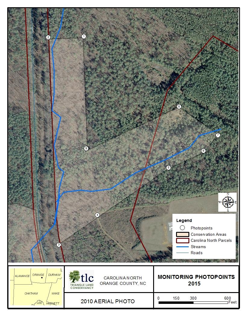
4 Map 4
5 Photo Documentation Table Bolin Creek East Photo Point Photo Number Description Azimuth 1 1 Northeast corner Northeast corner Northwest corner 85 4 Northwest corner Southwest corner Southwest corner Tree removal - 8 Tree removal Adjustment along the boundary Adjustment along the boundary Southeast corner Southeast corner Easternmost corner Easternmost corner Northeast corner Northeast corner Interior corner Interior corner 355 5


6 Photo #1. Northeast corner with view south down boundary. Photo #2. Northeast corner with view west down boundary towards railroad tracks. Photo #3. Northwest corner with view east back along boundary. Photo #4. Northwest corner with view south along boundary. Railroad tracks are visible on the right.


7 Photo #5. Southwestern corner with view north along boundary. Railroad tracks are visible on the left. Photo #6. Southwestern corner with view northeast along boundary towards the airport. Photo #7. Stumps at the edge of the airport inside the Conservation Area. Photo #8. Stumps at the edge of the airport inside the Conservation Area.


8 Photo #9. Corner along boundary with slight adjustment. View is southwest back down boundary. Photo #10. Corner along boundary with slight adjustment. View is northeast along boundary. Photo #11. Southeastern corner with view southwest back down boundary. Photo #12. Southeastern corner with view northeast along boundary.


9 Photo #13. Westernmost corner with view southwest back down boundary. Photo #14. Westernmost corner with view northeast along boundary. Photo #15. Northern corner on southern arm of Conservation Area with view back down boundary. Photo #16. Northern corner of southern arm with view southwest down boundary.


10 Photo #17. Interior corner with view northwest back along boundary. Photo #18. Interior corner with view north along boundary.
Triangle Land Conservancy Conservation Area Monitoring Report Carolina North
 Triangle Land Conservancy Conservation Area Monitoring Report Carolina North Property Name: Crow Branch Conservation Area Date of visit: 4/8/2015 County: Orange Property Type: Restrictive Covenants Local
Triangle Land Conservancy Conservation Area Monitoring Report Carolina North
 Triangle Land Conservancy Conservation Area Monitoring Report Carolina North Property Name: Bolin Creek East Conservation Area Date of visit: March 16, 2017 County: Orange Property Type: Restrictive Covenants
Triangle Land Conservancy Conservation Area Monitoring Report Carolina North
 Triangle Land Conservancy Conservation Area Monitoring Report Carolina North Property Name: Crow Branch Conservation Area Date of visit: March 16, 2016 County: Orange Property Type: Restrictive Covenants
Triangle Land Conservancy Conservation Area Monitoring Report Carolina North
 Triangle Land Conservancy Conservation Area Monitoring Report Carolina North Property Name: Bolin Creek West Conservation Area Date of visit: March 16, 2017 County: Orange Property Type: Restrictive Covenants
MORGAN CREEK GREENWAY Final Report APPENDICES
 APPENDICES MORGAN CREEK GREENWAY Appendix A Photos of Existing Conditions in Trail Corridor Photos of existing conditions Main trail corridor - February 2009 Photos of existing conditions south bank Morgan
DRAFT GENERAL IMPLEMENTATION PLAN AND SPECIFIC IMPLEMENTATION PLAN MIDDLETON MUNICIPAL AIRPORT MOREY FIELD. Revised 12/12/03
 DRAFT GENERAL IMPLEMENTATION PLAN AND SPECIFIC IMPLEMENTATION PLAN MIDDLETON MUNICIPAL AIRPORT MOREY FIELD Revised 12/12/03 As recommended for approval by the Plan Commission General Project Description
BRACEVILLE NATURE PRESERVE Introductions History Present Conditions Future Development Plans Implementation Strategies Statistics
 BRACEVILLE NATURE PRESERVE Introductions History Present Conditions Future Development Plans Implementation Strategies Statistics Introduction Braceville Nature Preserve is one of MetroParks largest preserves.
Greenways Commission Meeting Agenda Monday, March 20, 2017; 4:00 pm 7:00 pm Town Hall, Parking Lot
 Greenways Commission Meeting Agenda Monday, March 20, 2017; 4:00 pm 7:00 pm Town Hall, Parking Lot I. 4:00 4:05 pm Leave Town Hall Parking Lot for Briar Chapel II. III. IV. 4:30 pm Site Visit - Briar Chapel
Cultural Resource Management Report Deer Valley 4wd Restoration and Blue Lakes Road Maintenance Project R
 Cultural Resource Management Report R2015-05-03-10005 Undertaking Description: The proposes to perform road maintenance and meadow restoration on the Deer Valley 4wd trail and road maintenance on the Blue
Stephens Rd. Nature Preserve
 Stephens Rd. Nature Preserve History Stephens Road Nature Preserve (SRNP) is a 350-acre nature preserve in Huntersville that comprises nine properties purchased between 1994 and 2008. Parcels included
Public Notice ISSUED: December 10, 2018 EXPIRES: January 9, 2019
 APPLICANT: REFER TO: St. Louis and Lake Counties Regional Rail Authority 2018-01942-ARC Public Notice ISSUED: December 10, 2018 EXPIRES: January 9, 2019 SECTION:404 - Clean Water Act 1. APPLICATION FOR
Community Development Department Council Chambers, 7:30 PM, July 16, 2015
 STAFF REPORT 2015-25P: Zoning Chapter Amendment Community Development Department Council Chambers, 7:30 PM, July 16, 2015 To: From: Case: Paul Luke, Chairman, Skokie Plan Commission Steve Marciani, Planning
Short-Term Rentals Public Input. Thursday, November 5, 2015
 Short-Term Rentals Public Input Thursday, November 5, 2015 Outline City s timeline Survey results Other agencies comments Taxes Lodging numbers Other cities Q&A and/or discussion groups City s Timeline
Logo Department Name Agency Organization Organization Address Information 5700 North Sabino Canyon Road
 Logo Department Name Agency Organization Organization Address Information United States Forest Coronado National Forest 5700 North Sabino Canyon Road Department of Service Santa Catalina Ranger District
Watchorn Provincial Park. Management Plan
 Watchorn Provincial Park Management Plan 2 Watchorn Provincial Park Table of Contents 1. Introduction... 3 2. Park History... 3 3. Park Attributes... 3 3.1 Natural... 4 3.2 Recreational... 4 3.3 Additional
INTRODUCTION. Mailing address: Burke County Community Development Attn: Tim Johnson P. O. Box 219 Morganton, NC
 REQUEST FOR QUALIFICATIONS: PROFESSIONAL, EXPERIENCED TRAIL BUILDERS FOR THE CONSTRUCTION OF THE FONTA FLORA STATE TRAIL LAKE JAMES SECTION BURKE COUNTY COMMUNITY DEVELOPMENT INTRODUCTION Burke County
CHAPTER 16 STREETS, SIDEWALKS AND OTHER PUBLIC PLACES*
 CHAPTER 16 STREETS, SIDEWALKS AND OTHER PUBLIC PLACES* *Cross reference(s)--drainage commission, 2-111 et seq.; drainage districts created, 2-114; planning commission shall select and recommend to the
Appendix F Public authorities responses
 Planning Proposal under sec 55 of the EP&A Act LEP Refinements Appendix F Public authorities responses Appendix F Public authorities responses Prior to public exhibition, consultation was made with the
Ditch flows slowly to the north
 Ditch flows slowly to the north Photo 1. Wetland DE: Looking west across Wetland DE from upslope. Ponded water, mucky mineral soils, and patches of emergent vegetation observed. Wetland DE appears to be
Summary of prescribed fires in Prince Albert National Park 2015
 Summary of prescribed fires in Prince Albert National Park 2015 Prince Albert National Park conducted four controlled fires in spring 2015, plus an additional fire in October. Fuel Management for Hazard
ETOBICOKE CREEK NORTH TRAIL PROJECT. May 18, 2017 at Michael Power High School 105 Eringate Drive, Etobicoke ON M9C 3Z7
 ETOBICOKE CREEK NORTH TRAIL PROJECT May 18, 2017 at Michael Power High School 105 Eringate Drive, Etobicoke ON M9C 3Z7 1 Purpose of Open House The purpose of today s open house is to present the design
Lake Wissota Access Locations within the LaFayette Township. By Chad Martin
 Lake Wissota Access Locations within the LaFayette Township By Chad Martin Anson/ Wissota Access Point # 1 Road: 195 th St. Associated Fire Numbers: 13294 Defining Characteristics: Forested from road
Table 1: Iron Mountain Communication Site. Latitude 1 Longitude 1 Elev 2 Address T/R/S 3 APN 4 USGS Quadrangle
 County of Riverside Public Safety Enterprise Communication Project Appendix A: Candidate Site Descriptions Overview The site is located in San Bernardino County near several communication towers in the
CITY COUNCIL AGENDA MEMORANDUM
 To: Mayor and City Council From: Charles Ozaki, City and County Manager Prepared By: Kevin Standbridge, Deputy City and County Manager Katie Allen, City and County Engineer David Shinneman, Community Development
CARVER S FALLS. Cumberland County s Natural Beauty. What s Included In This Information Packette
 Cumberland County s Natural Beauty What s Included In This Information Packette History of the Falls Boy Scouts have acquired Right of Use Guidelines for Usage Application Check-out Report HISTORY AND
Understanding user expectations And planning for long term sustainability 1
 Understanding user expectations And planning for long term sustainability 1 What is a natural surface trail? It can be as simple has a mineral soil, mulched or graveled pathway, or as developed as elevated
ORDINANCE NO. 510 THEREFORE, BE IT ORDAINED BY THE GOVERNING BODY OF THE CITY OF BEL AIRE, KANSAS:
 (Published in The Ark Valley News on July, 2012.) ORDINANCE NO. 510 S-I-1 GILMORE & BELL, P.C. 07/11/2012 AN ORDINANCE CREATING A COMMUNITY IMPROVEMENT DISTRICT IN THE CITY OF BEL AIRE, KANSAS; AUTHORIZING
Rule Governing the Designation and Establishment of All-Terrain Vehicle Use Trails on State Land
 Rule Governing the Designation and Establishment of All-Terrain Vehicle Use Trails on State Land 1.0 Authority 1.1 This rule is promulgated pursuant to 23 V.S.A. 3506. Section 3506 (b)(4) states that an
State Environmental Planning Policy (Sydney Region Growth Centres) Amendment (Catherine Fields Precinct) 2013
 Amendment (Catherine Fields Precinct) 2013") New South Wales (Sydney Region Growth Centres) Amendment (Catherine Fields Precinct) 2013 under the Environmental Planning and Assessment Act 1979 Her Excellency the Governor, with the advice of the Executive
New South Wales (Sydney Region Growth Centres) Amendment (Catherine Fields Precinct) 2013 under the Environmental Planning and Assessment Act 1979 Her Excellency the Governor, with the advice of the Executive
Order of the Minister of Environment #39, August 22, 2011 Tbilisi
 Registration Code 360050000.22.023.016080 Order of the Minister of Environment #39, August 22, 2011 Tbilisi On preparatory stages and procedure of the methodology for Elaborating structure, content and
ARKANSAS HEADWATERS RECREATION AREA SPECIAL USE AGREEMENT RIDER ROCK CLIMBING, HIKING & MT. BIKING
 ARKANSAS HEADWATERS RECREATION AREA SPECIAL USE AGREEMENT RIDER ROCK CLIMBING, HIKING & MT. BIKING PURPOSE OF RIDER: To authorize Company Legal operating as Company dba the following activities for 2018
BARODA TOWNSHIP OPEN BURNING ORDINANCE. Ordinance No. 35
 BARODA TOWNSHIP OPEN BURNING ORDINANCE Ordinance No. 35 TABLE OF CONTENTS Section 1: Authority. 2 Section 2: Purpose...2 Section 3: Applicability......2 Section 4: Definitions...2 Section 5: Open burning
Phoenix Habitat Restoration Projects
 Phoenix Habitat Restoration Projects Spur Cross Ranch Cave Creek (Estergard) Regional Tree and Shade Summit March 9, 2010 Desert Riparian Ecosystems Healthy riparian areas like this once existed along
City of Durango 5.8 FUNDING TRAILS DEVELOPMENT
 5.8 FUNDING TRAILS DEVELOPMENT The City has been successful in establishing dedicated local funding sources as well as applying for grants to develop the City s trail system, having received nearly $2.4
PURPOSE AND NEED. Introduction
 Public Scoping: Allocation of Recreation Capacity for Commercial Outfitter Guide Services on North Kruzof Island Trails (Kruzof Island Outfitter Guide) PURPOSE AND NEED Introduction The U.S. Department
United States Department of the Interior National Park Service. Boundary Expansion Listed in National Register January 11, 2017
 NPS Form 10900-a (Rev. 8/2002) OMB No. 10240018 United States Department of the Interior National Park Service Boundary Expansion Listed in National Register January 11, 2017 National Register of Historic
The meeting was held at the hour of 1:30 p.m. in the Conference Room of the Public Works Operations Building, 4825 Gleason Drive, Dublin, California.
 MINUTES OF MEETING (APPROVED JULY 28, 2005) The meeting was held at the hour of 1:30 p.m. in the Conference Room of the Public Works Operations Building, 4825 Gleason Drive, Dublin, California. FIELD TRIP:
-NOTE: NOT TO BE USED FOR NAVIGATION PURPOSES-
 APPENDIX 1-B INSTRUMENT APPROACH PROCEDURES March 2010 SKYHAVEN AIRPORT -NOTE: NOT TO BE USED FOR NAVIGATION PURPOSES- -NOTE: NOT TO BE USED FOR NAVIGATION PURPOSES- -NOTE: NOT TO BE USED FOR NAVIGATION
The Corporation of the Township of Wollaston By-law Being a by-law to licence recreational vehicles and tents in the Township of Wollaston
 By-law 38-17 Being a by-law to licence recreational vehicles and tents in the Township of Wollaston WHEREAS Section 164 of the Municipal Act, 2001 as amended, authorizes the municipality to prohibit or
TABLE OF CONTENTS 1.0 INTRODUCTION...
 Staff Instruction Subject: Eligibility of American and Mexican Registered Aircraft for Operation Under the North American Issuing Office: Standards Activity Area: Qualifying Document No.: SI 500-005 File
Appendix L Technical Memorandum Aesthetics
 Technical Memorandum Aesthetics 1.0 AESTHETICS This section provides a discussion of the aesthetic resources in the vicinity of ARTIC. Aesthetics pertain to the elements that make a certain view pleasing
STEPS REQUIRED TO OBTAIN A BUILDING PERMIT. 1. Obtain copy of Building Guidelines for River Ridge and Building Permit application.
 STEPS REQUIRED TO OBTAIN A BUILDING PERMIT 1. Obtain copy of Building Guidelines for River Ridge and Building Permit application. 2. Obtain copy of your plat. MARK ALL PROPERTY LINES. 3. Turn your completed
Gravel and Rock Extraction Highway Maintenance, Recapitalization and Twinning
 Gravel and Rock Extraction Highway Maintenance, Recapitalization and Twinning Backgrounder: Mountain National Parks A Need for Change Existing supplies of aggregate (sand and gravel) for highway maintenance,
ORDER CALLING PUBLIC HEARING TOBE HELD ON MARCH 2, 2016
 A regular meeting of the Town Board of the Town of New Windsor, in the County of Orange, New York, was held at the Town Hall, in said Town, on the 3rd day of February, 2016. PRESENT: George A. Green, Supervisor
b. Minimum Site Area. Recreational vehicle parks shall be located on a parcel of land not less than 3 acres in area.
 6450 RECREATIONAL VEHICLE PARK REGULATIONS 6450 TITLE AND PURPOSE. The provisions of Section 6450 through 6499, inclusive, shall be known as the Recreational Vehicle Park Regulations. The purpose of these
Finn Creek Park. Management Direction Statement Amendment
 Finn Creek Park Management Direction Statement Amendment November 2013 Management Direction Statement Amendment Approved by: Jeff Leahy Regional Director, Thompson Cariboo BC Parks November 12, 2013 Date
UNITED STATES DEPARTMENT OF THE INTERIOR BUREAU OF LAND MANAGEMENT MANUAL TRANSMITTAL SHEET
 Form 1221-2 (June 1969) UNITED STATES DEPARTMENT OF THE INTERIOR BUREAU OF LAND MANAGEMENT MANUAL TRANSMITTAL SHEET Release 8-83 Date Subject 8353 Trail Management Areas Secretarially Designated (Public)
M E M O R A N D U M. Status of the Environmental Cleanup of the Shipyard
 ECONOMIC AND WORKFORCE DEVELOPMENT MICHAEL COHEN, DIRECTOR CITY AND COUNTY OF SAN FRANCISCO GAVIN NEWSOM, MAYOR M E M O R A N D U M TO: Members of the Health Commission FROM: Michael Cohen CC: Mitch Katz,
County of Riverside - PSEC Project General Habitat Assessment Appendix A
 County of Riverside - PSEC Project General Habitat Assessment Appendix A Lake Elsinore Lake Elsinore The Lake Elsinore study area is located in the hills directly adjacent to Lake Elsinore, in the City
FIRE Equipment Fire Training Equipment 105, , Total of Equipment 105, ,
 FIRE Equipment Fire Training Equipment 105,000-105,000 - - - - - - - - - - Total of Equipment 105,000-105,000 - - - - - - - - - - Fire Apparatus Aerial Ladder Replacement 5,320,000 1,120,000 - - 1,400,000
Appendix C. Tenderfoot Mountain Trail System. Road and Trail Rehabilitation Plan
 Appendix C Tenderfoot Mountain Trail System Road and Trail Rehabilitation Plan All rehabilitation work would be under the direction of the District Fisheries Biologist, the Forest Hydrologist, and/or the
EXPERIMENTAL OPERATING LIMITATIONS EXHIBITION GROUP I1
 US. Department of Transportatlon Federal Aviation Administration MA[. 2 3 2000 Flight Standards District Office EXPERIMENTAL OPERATING LIMITATIONS EXHIBITION GROUP I1 Registration No:N7237K Make:Bell Model:206A-l
O R D I N A N C E NO AN ORDINANCE, amending Section Two of Ordinance No. 1864, adopted April 3, 1969 and revising the boundaries of
 O R D I N A N C E NO. 2032 AN ORDINANCE, amending Section Two of Ordinance No. 1864, adopted April 3, 1969 and revising the boundaries of Subdistrict No. 268 (Lin-Ferry - Tesson Ferry) of The Metropolitan
Crown Lands and Property Agency. Name Client # LAST (Please Print) FIRST MIDDLE (no initials) Mailing Address. Postal Code
 FIRST MIDDLE (no initials) Mailing Address. Postal Code") Manitoba Conservation and Water Stewardship Application for Permit/Lease/Purchase/Easement/Exchange/Licence of Occupation (under The Crown Lands Act c.c340) Please check one ( ) Permit Lease Purchase Easement
Manitoba Conservation and Water Stewardship Application for Permit/Lease/Purchase/Easement/Exchange/Licence of Occupation (under The Crown Lands Act c.c340) Please check one ( ) Permit Lease Purchase Easement
Greening Project Status Report: Grand Canyon National Park
 Greening Project Status Report: Grand Canyon National Park Prepared for the Federal Energy Management Program U.S. Department of Energy February 2001 iii Contents Page 1. Introduction... 1 2. Context of
Proposed Official Plan Amendment 41 to the Region of York Official Plan
 COMMITTEE OF THE WHOLE NOVEMBER 18, 2002 REGION OF YORK OFFICIAL PLAN AMENDMENT 41 THE OAK RIDGES MORAINE CONSERVATION PLAN Recommendation The Commissioner of Planning recommends: 1. That the City of Vaughan
GREENSBORO-JAMESTOWN JOINT ANNEXATION AGREEMENT
 NORTH CAROLINA GUILFORD COUNTY GREENSBORO-JAMESTOWN JOINT ANNEXATION AGREEMENT THIS AGREEMENT, made and entered into this the day of, 2011 by and between the City of Greensboro and the Town of Jamestown.
Fossil Creek Wild & Scenic River Comprehensive River Management Plan Forest Service Proposed Action - details March 28, 2011
 Fossil Creek Wild & Scenic River Comprehensive River Management Plan Forest Service Proposed Action - details March 28, 2011 Primary Goals of the Proposed Action 1. Maintain or enhance ORVs primarily by
National Recreation Trail Update Form
 National Recreation Trail Update Form Introduction Thank you for taking the time to complete this form. Your assistance will help ensure that the National Recreation Trail (NRT) database is complete and
June 6, 2013 BOARD MATTER D - 5 CONSIDER AMENDMENT OF SPECIAL USE LEASE NO. SU-639 AND REQUEST FOR PUBLIC USE RESTRICTION TO MOTORIZED VEHICULAR USE
 June 6, 2013 BOARD MATTER D - 5 ACTION: AUTHORITY: CONSIDER AMENDMENT OF SPECIAL USE LEASE NO. SU-639 AND REQUEST FOR PUBLIC USE RESTRICTION TO MOTORIZED VEHICULAR USE W.S. 36-5-114; Board of Land Commissioners
Meadow Lake Airport Glider Operations Procedures
 Meadow Lake Airport Glider Operations Procedures The MLAA Board has delegated to High Flights Soaring Club responsibility for coordinating glider activities at Meadow Lake Airport and establishing procedures
Kansas (KAW) River History
 River History") Kansas (KAW) River History The first map of the Kansas River is dated back to 1718. Lewis and Clark spent 3 days camped at Kaw Point at the confluence of the Kansas and Missouri Rivers. Kansas (KAW) River
Kansas (KAW) River History The first map of the Kansas River is dated back to 1718. Lewis and Clark spent 3 days camped at Kaw Point at the confluence of the Kansas and Missouri Rivers. Kansas (KAW) River
The north half of Section 18, Township 37 North, Range 6 East, Second Principal Meridian, Jefferson Township, Elkhart County, Indiana; also,
 The north half of Section 18, Township 37 North, Range 6 East, Second Principal Meridian, Jefferson Township, Elkhart County, Indiana; also, The east half of Sections 21, 28, and 33, Township 37 North,
APPLICATION FOR TENTS/INFLATABLES
 APPLICATION FOR TENTS/INFLATABLES City of Johnson City Codes Division 601 East Main Street Johnson City, TN 37601 (423) 434-6047 TENT SECTION Approval Date: Application No: Date Issued: Permit Fee: Expiration
Action Recommendation: Budget Impact:
 City of Fayetteville Staff Review Form Matt Mihalevich 1/16/2019 DEVELOPMENT SERVICES (620) Submitted By 2019 0050 Legistar File ID February 5th, 2019 City Council Meeting Date Agenda Item Only N/A for
New Jersey Department of Transportation
 Administration, Organization, Records Management & Information Requests 16:1A-4.4(a) Copying fees - Records Page 1 10: $0.75 per page Page 11 20: $0.50 per page Over 20 pages - $0.25 per page 16:1A-4.5(c)
PLANNING BOARD MINUTES March 13, 2017 CASCO COMMUNITY CENTER 7:00 P.M. MEMBERS PRESENT: Stan Buchanan, Ray Grant & Lynne Potter Bob Barnes, Ted
 PLANNING BOARD MINUTES March 13, 2017 CASCO COMMUNITY CENTER 7:00 P.M. MEMBERS PRESENT: Stan Buchanan, Ray Grant & Lynne Potter MEMBERS ABSENT: Bob Barnes, Ted Beckner & Jim Macklin STAFF PRESENT: James
Dumont Dunes Special Recreation Management Area (SRMA)
") Dumont Dunes Special Recreation Management Area (SRMA) RMA/RECREATION MANAGEMENT ZONE (RMZ) OBJECTIVE(S) DECISIONS Objective Statement: Designate this area as a Special Recreation Management Area. To manage
Dumont Dunes Special Recreation Management Area (SRMA) RMA/RECREATION MANAGEMENT ZONE (RMZ) OBJECTIVE(S) DECISIONS Objective Statement: Designate this area as a Special Recreation Management Area. To manage
ROUTE ANALYSIS PROCESS
 ROUTE ANALYSIS PROCESS Progress to Date: 1. Recorded and labeled all routes received from PAT Meetings. 2. Determined opportunity, avoidance and exclusion areas crossed by PAT proposed routes. 3. Routes
Gardner: overview. Santa Fe, Oregon, and California National Historic Trails UNINCORPORATED JOHNSON COUNTY OLATHE UNINCORPORATED JOHNSON COUNTY
 Santa Fe, Oregon, and California ational Historic Trails : overview 99: p.134 100: p.135 GARDER JUCTIO 102: p.137 56: p.126 EDGERTO Burlington orthern Intermodal and Logistics 98: p.133 101: p.136 S Waverly
TANGI RC FLYERS ASSOCIATION
 TANGI RC FLYERS ASSOCIATION FLYING FIELD SAFETY RULES Revision 9 Amended January 1 st, 2018 INTRODUCTION Everyone is hurt when a careless action causes an accident. Most modelers will react favorably and
Notice of Intent of Waiver with Respect to Land; Fort Wayne International Airport, Fort Wayne, IN. AGENCY: Federal Aviation Administration (FAA), DOT.
, DOT.") This document is scheduled to be published in the Federal Register on 03/23/2018 and available online at https://federalregister.gov/d/2018-05888, and on FDsys.gov [4910-13] DEPARTMENT OF TRANSPORTATION
This document is scheduled to be published in the Federal Register on 03/23/2018 and available online at https://federalregister.gov/d/2018-05888, and on FDsys.gov [4910-13] DEPARTMENT OF TRANSPORTATION
RIVERDALE CITY CITY COUNCIL AGENDA January 20, 2009 AGENDA ITEM:
 RIVERDALE CITY CITY COUNCIL AGENDA January 20, 2009 AGENDA ITEM: G3 SUBJECT: Consideration of Ordinance #728 adopting a new Chapter under Title 4, Public Health and Safety, Chapter 5b, Camping. PETITIONER:
Bear Creek Habitat Improvement Project
 06/10/10 Bear Creek Habitat Improvement Project El Paso County, Colorado Pike National Forest and Colorado Springs Utilities Owned Land Report prepared by: Eric Billmeyer Executive Director Rocky Mountain
Administration Policies & Procedures Section Commercial Ground Transportation Regulation
 OBJECTIVE METHOD OF OPERATION Definitions To promote and enhance the quality of Commercial Ground Transportation, the public convenience, the safe and efficient movement of passengers and their luggage
Mt. Hood National Forest
 United States Department of Agriculture Forest Service Mt. Hood National Forest Zigzag Ranger District 70220 E. Highway 26 Zigzag, OR 97049 503-622-3191 Fax: 503-622-5622 File Code: 1950-1 Date: June 29,
Action Recommendation: Budget Impact:
 City of Fayetteville Staff Review Form 2018-0600 Legistar File ID 11/8/2018 City Council Meeting Date - Agenda Item Only N/A for Non-Agenda Item Leif Olson 10/17/2018 SUSTAINABILITY/RESILIENCE (631) Submitted
Lawrence Loop SWOT Analysis
 Alignment: D1 (Map Color: Dark Blue) Description: This alignment connects to the north end of the Burroughs Creek Trail and continues along the west side of the Railroad to 8 th Street. Strengths: - This
COUNCIL OF CECIL COUNTY, MARYLAND DEPARTMENT OF PUBLIC WORKS ROADS DIVISION ADOPT-A-ROAD
 COUNCIL OF CECIL COUNTY, MARYLAND DEPARTMENT OF PUBLIC WORKS ROADS DIVISION ADOPT-A-ROAD 1 CECIL COUNTY ADOPT-A-ROAD PROGRAM Please join us in our Adopt-A-Road Program! Contact the Cecil County Roads Department
Flying Cloud Airport (FCM) Zoning Process: Informing a Mn/DOT Path Forward
 Zoning Process: Informing a Mn/DOT Path Forward") : Informing a Mn/DOT Path Forward A Review of the Flying Cloud Airport (FCM) Joint Airport Zoning Board (JAZB) Process and the Draft Airport Zoning Ordinance B A RPZ RPZ A B C Zone Chad E. Leqve Director
: Informing a Mn/DOT Path Forward A Review of the Flying Cloud Airport (FCM) Joint Airport Zoning Board (JAZB) Process and the Draft Airport Zoning Ordinance B A RPZ RPZ A B C Zone Chad E. Leqve Director
Coronado National Forest Santa Catalina Ranger District
 United States Department of Agriculture Forest Service Coronado National Forest Santa Catalina Ranger District File Code: 1950 Date: October 14, 2015 Dear Interested Party: The Santa Catalina Ranger District
San Juan Resource Area Recreation Impact Inventory/Monitoring
 San Juan Resource Area Recreation Impact Inventory/Monitoring Indian Creek Climbing Area Overview & Summary of Findings 2007 Pam Foti, Professor Aaron Divine, Lecturer Janet Lynn, Program Coordinator Northern
Public Notice for Waiver of Aeronautical Land-Use Assurance. AGENCY: Federal Aviation Administration (FAA), DOT
, DOT") This document is scheduled to be published in the Federal Register on 09/06/2017 and available online at https://federalregister.gov/d/2017-18845, and on FDsys.gov [4910-13] DEPARTMENT OF TRANSPORTATION
This document is scheduled to be published in the Federal Register on 09/06/2017 and available online at https://federalregister.gov/d/2017-18845, and on FDsys.gov [4910-13] DEPARTMENT OF TRANSPORTATION
Hydraulic Report. Trail 5 Snowmobile Trail Over Mulligan Creek. Prepared By: COLEMAN ENGINEERING COMPANY Karisa V. Falls, P.E.
 Prepared for: Prepared by: Marquette County Road Commission Coleman Engineering Company Marquette, Michigan Iron Mountain, MI December 2011 Hydraulic Report Trail 5 Snowmobile Trail Over Mulligan Creek
Francis Marion and Sumter National Forests
 United States Department of Agriculture Forest Service Francis Marion and Sumter National Forests 2967 Steed Creek Rd. Huger, SC 29450 Tele: (843)336-2200 File Code: 1950 Date: February 13, 2015 To Whom
Building Permit Application
 Building Permit Application Co-Owner Name Lot # Address City State Zip Phone (home) (cell) Contractor (if applicable) The above named co-owner hereby makes application to Cedar Shores Campground Condominium
Daisy Dean Trail 628/619 ATV Trail Construction
 Background and Purpose and Need The Daisy Dean ATV Trail Construction Project is located in the Little Belt Mountains, Musselshell Ranger District, Lewis and Clark National Forest approximately 32 miles
National Wilderness Steering Committee
 National Wilderness Steering Committee Guidance White Paper Number 1 Issue: Cultural Resources and Wilderness Date: November 30, 2002 Introduction to the Issue Two of the purposes of the National Wilderness
AIRPORT EMERGENCY CONTINGENCY PLAN TEMPLATE V 3.3 April 27, 2012
 AIRPORT EMERGENCY CONTINGENCY PLAN TEMPLATE V 3.3 April 27, 2012 Section 42301 of the FAA Modernization and Reform Act of 2012 1 (the Act) requires airport operators to submit emergency contingency plans
GHANA CIVIL AVIATION (ECONOMIC)
") GHANA CIVIL AVIATION (ECONOMIC) DIRECTIVES, 2017 PART 2 IS: 1-1 This Directive deals with passengers' Rights and Air Operators Obligations to passengers. This Directive addresses consumer protection issues
GHANA CIVIL AVIATION (ECONOMIC) DIRECTIVES, 2017 PART 2 IS: 1-1 This Directive deals with passengers' Rights and Air Operators Obligations to passengers. This Directive addresses consumer protection issues
USDA Forest Service Deschutes National Forest DECISION MEMO. Round Lake Christian Camp Master Plan for Reconstruction and New Facilities
 USDA Forest Service Deschutes National Forest DECISION MEMO Round Lake Christian Camp Master Plan for Reconstruction and New Facilities Jefferson County, Oregon T. 13 S., R. 8 E., Section 16, W.M. Background:
Santa Clara South Hills Recreation Park Project Development and Management Plan
 Santa Clara South Hills Recreation Park Project Application for Land for Recreation or Public Purposes, City of Santa Clara, Utah Prepared for: Bureau of Land Management, St. George Field Office 345 East
Preliminary Findings of Proposed Alternative
 Preliminary Findings of Proposed Alternative The attached drawing provides a schematic layout of the proposed alternative that will be discussed on July 27, 2010. A full report will follow and should be
Administration Policies & Procedures Section Commercial Ground Transportation Regulation
 OBJECTIVE METHOD OF OPERATION Definitions To promote and enhance the quality of Commercial Ground Transportation, the public convenience, the safe and efficient movement of passengers and their luggage
CORPS OF ENGINEERS ALASKA DISTRICT Dredging Projects. Michael Tencza, PE Operations Project Manager November 4, 2015
 CORPS OF ENGINEERS ALASKA DISTRICT 2016 Dredging Projects Michael Tencza, PE Operations Project Manager November 4, 2015 US Army Corps of Engineers Building and Preserving Alaska s Future AWARDED CONTRACTS
The Summit County Open Space and Trails Regulations
 The Summit County Open Space and Trails Regulations ADOPTED PURSUANT TO RESOLUTION NO. 2007-59 ON AUGUST 14, 2007 AMENDED PURSUANT TO RESOLUTION NO. 2015-55 ON OCTOBER 16, 2015 Section 1. Intent The Summit
THREE MILE PLAN TOWN OF SUPERIOR COLORADO
 THREE MILE PLAN TOWN OF SUPERIOR COLORADO February 23, 2015 INTRODUCTION This document has been prepared by the Town of Superior, Colorado, to address the existing and proposed land uses within an approximate
North Carolina (Statewide) 2016 Prosperity Zone Data Books
 2016 Prosperity Zone Data Books") North Carolina (Statewide) 2016 Prosperity Zone Data Books 2 North Carolina Prosperity Zones Western North Carolina Prosperity Zones Northwest Region Piedmont-Triad Region Western Region Southwest Region
North Carolina (Statewide) 2016 Prosperity Zone Data Books 2 North Carolina Prosperity Zones Western North Carolina Prosperity Zones Northwest Region Piedmont-Triad Region Western Region Southwest Region
Tourism Impacts and Second Home Development in Pender County: A Sustainable Approach
 Tourism Impacts and Second Home Development in Pender County: A Sustainable Approach (Funded by North Carolina Sea Grant) Center for Sustainable Tourism Division of Research and Graduate Studies East Carolina
VoIP RADIO CONSOLE SYSTEM FOR MACON COUNTY EMERGENCY MANAGEMENT
 REQUEST FOR BIDS AND PROPOSALS BID REQUEST NO. 4375-02 VoIP RADIO CONSOLE SYSTEM FOR MACON COUNTY EMERGENCY MANAGEMENT ISSUE DATE: December 23, 2011 BID OPENING DATE: JANUARY 11, 2012 3:00 PM LOCAL TIME