Triangle Land Conservancy Conservation Area Monitoring Report Carolina North
|
|
|
- Ethel Briggs
- 5 years ago
- Views:
Transcription
 514 S. Duke St.")
1 Triangle Land Conservancy Conservation Area Monitoring Report Carolina North Property Name: Bolin Creek West Conservation Area Date of visit: March 16, 2017 County: Orange Property Type: Restrictive Covenants Local Contact: Triangle Land Conservancy (office) 514 S. Duke St (fax) Durham, NC Lead conservation area monitor: Laura Stroud Other person(s) attending inspection: none The Carolina North Property is subject to a Declaration of Restrictive Covenants recorded in Book 5541 page 360 of the Office of the Orange County Register of Deeds. A copy of the Restrictive Covenants may be found at the Register of Deeds office or the link below. Conservation-Areas-.pdf There is a LAND STEWARDSHIP POLICY on file for this property. The Land Stewardship Policy was completed January 15, 2013 and is available at the link below. February pdf Problem areas noted from prior visits and areas to pay special attention to: Minor dumping still occurs along western boundary that is shared with residences, as was noted in the 2014 monitoring report. No new dumping was observed and the issue appears to be resolved. 1
2 TLC Conservation Area Monitoring Report (Cont.) Are property boundaries clearly marked? Note any new concerns about boundaries and signs of encroachment, and if existing problems have been corrected? Yes. Boundaries clearly marked. No areas of concern. The Restrictive Covenants list eight restricted or prohibited uses and activities. Are there any violations of the following restricted or prohibited uses and activities? A. Construction. Construction or placement of buildings, roads, billboards or other advertising, utilities or other structures on or above the ground is prohibited in the Conservation Areas. Construction or placement of signs is prohibited in the Conservation Areas except for directional and boundary signs, interpretive signs describing the conservation values of the Conservation Areas, and signs and kiosks prescribing rules and regulations for the use of the Conservation Areas. No new construction was observed. B. Dumping and Landfill Activities. Dumping or placing soil or other substances or materials as landfill, or dumping or placing trash, waste or unsightly or offensive materials is prohibited in the Conservation Areas. No new dumping encroachment was observed along western boundary. C. Vegetation Destruction. Removal or destruction of healthy native trees, shrubs or other vegetation is prohibited in the Conservation Areas, unless done as a component of an established forest management plan. No vegetation destruction was observed. D. Excavation or Dredging. Excavation, dredging or removal of loam, peat, gravel, soil, rock or other mineral substance in such manner as to affect the surface is prohibited in the Conservation Areas. No excavation or dredging was observed. E. Detrimental Surface Use. Surface use except for forest or outdoor recreational purposes or purposes permitting the land or water area to remain predominantly in its natural condition is prohibited in the Conservation Areas. No detrimental surface use was observed. 2
3 F. Activities Detrimental to Drainage; Flood Control, etc. Activities detrimental to drainage, flood control, water conservation, erosion control or soil conservation are prohibited in the Conservation Areas. No activities detrimental to drainage, flood control or other listed items were observed. University personnel may wish to monitor the retention pond and silt fence near the northwestern boundary more frequently than annually, especially after heavy rains. G. Other Detrimental Acts. Other acts or uses detrimental to the retention of land or water areas are prohibited in the Conservation Areas. Based on our observation, the University has been a good steward of the Carolina North property; no detrimental acts were observed during our visits. H. Construction of New Trails and Greenways. Construction of new trails (except for potential greenways and paths that are located and approved pursuant to the terms of the Development Agreement) is prohibited in the Conservation Areas. No new trails or greenways were observed. TLC Recomends taking corrective action to reduce erosion and trail degradation to ensure the long-term viability of the trail infrastructure. Carolina North staff has resolved this issue. Additional comments or observations There was no new dumping encroachment observed. The retention pond on the boundary at Photopoint 5 appears to be functioning properly. To the best of your knowledge and observation, is the land owner complying with the restrictive covenants? YES Steward s name: Laura Stroud Signature: Laura K. Stroud Address: 514 S. Duke St. Phone: Durham, NC Indicate attachments to the report. Date and sign all materials. Provide descriptions of photograph and illustration locations. ground photos aerial photos maps illustrations other 3
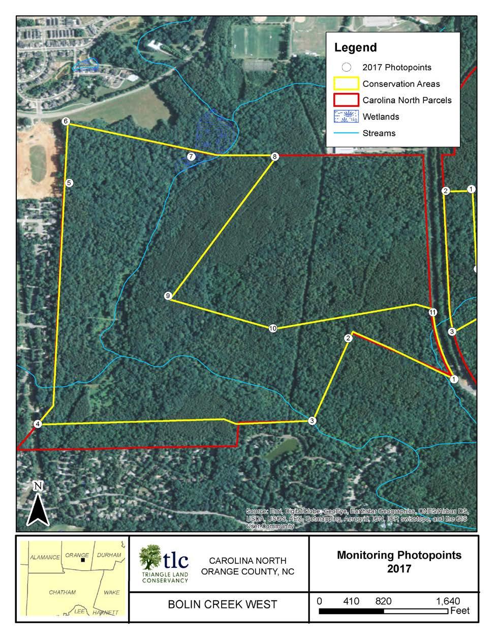
4 Map 4
5 Photo Documentation Table Photo Point Photo Number Description Azimuth 1 a Corner 340 b Corner a Corner 150 b Corner a Corner 15 b Corner a Corner 90 b Corner 30 5 a Retention pond 5 b Retention pond a Corner 170 b Corner a Water on trail 80 b Water on trail 80 8 a Corner 280 b Corner a Corner 40 b Corner a Corner 280 b Corner a Corner 290 b Corner 165 5


6 Photopoint 1a: Corner with view north along conservation Photopoint 1b: Corner with view northwest along Photopoint 2a: Corner with view southeast along Photopoint 2b: Corner with view southwest along


7 Photopoint 3a: Corner with view northeast along Photopoint 3b: Corner with view west along conservation Photopoint 4a: Corner with view east along conservation Photopoint 4b: Corner with view northeast along


8 Photopoint 5a: Conservation area boundary with view north along new construction retention pond. Photopoint 5b: Conservation area boundary with view east along outlet of new construction retention pond. Photopoint 6a: Corner with view south along conservation Photopoint 6b: Corner with view east along conservation


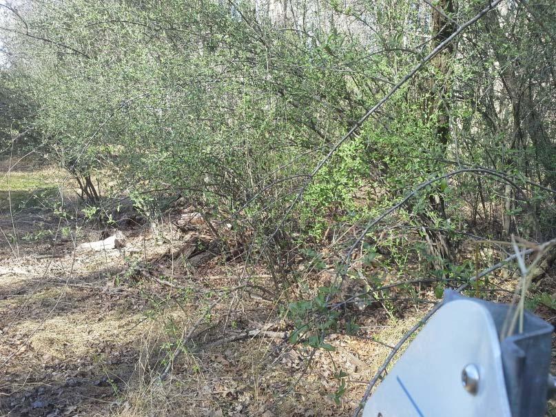
9 Photopoint 7: Trail with view east toward water damage to trails on conservation area. Photopoint 7b: Trail with view east toward water damage to trails on conservation area. Photopoint 8a: Corner with view west along conservation Photopoint 21b: Corner with view southwest along


10 Photopoint 9a: Corner with view northeast along Photopoint 9b: Corner with view southeast along Photopoint 10a: Corner with view northwest along Photopoint 10b: Corner with view east along conservation


11 Photopoint 11a: Corner with view northeast along Photopoint 11b: Corner with view south along conservation
Triangle Land Conservancy Conservation Area Monitoring Report Carolina North
 Triangle Land Conservancy Conservation Area Monitoring Report Carolina North Property Name: Bolin Creek East Conservation Area Date of visit: March 16, 2017 County: Orange Property Type: Restrictive Covenants
Triangle Land Conservancy Conservation Area Monitoring Report Carolina North
 Triangle Land Conservancy Conservation Area Monitoring Report Carolina North Property Name: Crow Branch Conservation Area Date of visit: March 16, 2016 County: Orange Property Type: Restrictive Covenants
Triangle Land Conservancy Conservation Area Monitoring Report Carolina North
 Triangle Land Conservancy Conservation Area Monitoring Report Carolina North Property Name: Crow Branch Conservation Area Date of visit: 4/8/2015 County: Orange Property Type: Restrictive Covenants Local
Triangle Land Conservancy Conservation Area Monitoring Report Carolina North
 Triangle Land Conservancy Conservation Area Monitoring Report Carolina North Property Name: Bolin Creek East Conservation Area Date of visit: 4/8/2015 County: Orange Property Type: Restrictive Covenants
MORGAN CREEK GREENWAY Final Report APPENDICES
 APPENDICES MORGAN CREEK GREENWAY Appendix A Photos of Existing Conditions in Trail Corridor Photos of existing conditions Main trail corridor - February 2009 Photos of existing conditions south bank Morgan
DRAFT GENERAL IMPLEMENTATION PLAN AND SPECIFIC IMPLEMENTATION PLAN MIDDLETON MUNICIPAL AIRPORT MOREY FIELD. Revised 12/12/03
 DRAFT GENERAL IMPLEMENTATION PLAN AND SPECIFIC IMPLEMENTATION PLAN MIDDLETON MUNICIPAL AIRPORT MOREY FIELD Revised 12/12/03 As recommended for approval by the Plan Commission General Project Description
Public Notice ISSUED: December 10, 2018 EXPIRES: January 9, 2019
 APPLICANT: REFER TO: St. Louis and Lake Counties Regional Rail Authority 2018-01942-ARC Public Notice ISSUED: December 10, 2018 EXPIRES: January 9, 2019 SECTION:404 - Clean Water Act 1. APPLICATION FOR
ETOBICOKE CREEK NORTH TRAIL PROJECT. May 18, 2017 at Michael Power High School 105 Eringate Drive, Etobicoke ON M9C 3Z7
 ETOBICOKE CREEK NORTH TRAIL PROJECT May 18, 2017 at Michael Power High School 105 Eringate Drive, Etobicoke ON M9C 3Z7 1 Purpose of Open House The purpose of today s open house is to present the design
Stephens Rd. Nature Preserve
 Stephens Rd. Nature Preserve History Stephens Road Nature Preserve (SRNP) is a 350-acre nature preserve in Huntersville that comprises nine properties purchased between 1994 and 2008. Parcels included
Lake Wissota Access Locations within the LaFayette Township. By Chad Martin
 Lake Wissota Access Locations within the LaFayette Township By Chad Martin Anson/ Wissota Access Point # 1 Road: 195 th St. Associated Fire Numbers: 13294 Defining Characteristics: Forested from road
Logo Department Name Agency Organization Organization Address Information 5700 North Sabino Canyon Road
 Logo Department Name Agency Organization Organization Address Information United States Forest Coronado National Forest 5700 North Sabino Canyon Road Department of Service Santa Catalina Ranger District
Ditch flows slowly to the north
 Ditch flows slowly to the north Photo 1. Wetland DE: Looking west across Wetland DE from upslope. Ponded water, mucky mineral soils, and patches of emergent vegetation observed. Wetland DE appears to be
Section 61 Recreational Vehicle Park / Campground (Bylaw No. 2012/10)
") Part 7 General Regulations Section 61 Recreational Vehicle Park / Campground (Bylaw No. 2012/10) 61.1 A comprehensive site plan shall be provided to the satisfaction of the Development Authority that shows
Part 7 General Regulations Section 61 Recreational Vehicle Park / Campground (Bylaw No. 2012/10) 61.1 A comprehensive site plan shall be provided to the satisfaction of the Development Authority that shows
CHAPTER 16 STREETS, SIDEWALKS AND OTHER PUBLIC PLACES*
 CHAPTER 16 STREETS, SIDEWALKS AND OTHER PUBLIC PLACES* *Cross reference(s)--drainage commission, 2-111 et seq.; drainage districts created, 2-114; planning commission shall select and recommend to the
Rule Governing the Designation and Establishment of All-Terrain Vehicle Use Trails on State Land
 Rule Governing the Designation and Establishment of All-Terrain Vehicle Use Trails on State Land 1.0 Authority 1.1 This rule is promulgated pursuant to 23 V.S.A. 3506. Section 3506 (b)(4) states that an
Conservation Area Management Statement
 Conservation Area Management Statement Miller Creek Wildlife Area Resolution #: Approval: Issue Date: Date of Last Revision: Table of Contents 1. Purpose....... 1 2. Property Description...... 1 2.1. Legal
Appendix F Public authorities responses
 Planning Proposal under sec 55 of the EP&A Act LEP Refinements Appendix F Public authorities responses Appendix F Public authorities responses Prior to public exhibition, consultation was made with the
APPLICATION FOR TENTS/INFLATABLES
 APPLICATION FOR TENTS/INFLATABLES City of Johnson City Codes Division 601 East Main Street Johnson City, TN 37601 (423) 434-6047 TENT SECTION Approval Date: Application No: Date Issued: Permit Fee: Expiration
TOWN OF SWANSBORO Planning Board Regular Meeting Community Room AGENDA
 TOWN OF SWANSBORO Planning Board Regular Meeting Community Room April 4, 2016 Monday 6:00 pm Town Hall 601 W. Corbett Ave. AGENDA 1. Call to Order 2. Roll Call and Quorum Verification 3. Approval of Meeting
BRACEVILLE NATURE PRESERVE Introductions History Present Conditions Future Development Plans Implementation Strategies Statistics
 BRACEVILLE NATURE PRESERVE Introductions History Present Conditions Future Development Plans Implementation Strategies Statistics Introduction Braceville Nature Preserve is one of MetroParks largest preserves.
Bear Creek Habitat Improvement Project
 06/10/10 Bear Creek Habitat Improvement Project El Paso County, Colorado Pike National Forest and Colorado Springs Utilities Owned Land Report prepared by: Eric Billmeyer Executive Director Rocky Mountain
DEVELOPMENT & APPLICATION OF THE STATE COORDINATE SYSTEM
 DEVELOPMENT & APPLICATION OF THE STATE COORDINATE SYSTEM State of North Carolina North Carolina Department of Public Safety Division of Emergency Management North Carolina Geodetic Survey www.ncgs.state.nc.us/
COUNCIL OF CECIL COUNTY, MARYLAND DEPARTMENT OF PUBLIC WORKS ROADS DIVISION ADOPT-A-ROAD
 COUNCIL OF CECIL COUNTY, MARYLAND DEPARTMENT OF PUBLIC WORKS ROADS DIVISION ADOPT-A-ROAD 1 CECIL COUNTY ADOPT-A-ROAD PROGRAM Please join us in our Adopt-A-Road Program! Contact the Cecil County Roads Department
INTRODUCTION. Mailing address: Burke County Community Development Attn: Tim Johnson P. O. Box 219 Morganton, NC
 REQUEST FOR QUALIFICATIONS: PROFESSIONAL, EXPERIENCED TRAIL BUILDERS FOR THE CONSTRUCTION OF THE FONTA FLORA STATE TRAIL LAKE JAMES SECTION BURKE COUNTY COMMUNITY DEVELOPMENT INTRODUCTION Burke County
ORDINANCE NO. 510 THEREFORE, BE IT ORDAINED BY THE GOVERNING BODY OF THE CITY OF BEL AIRE, KANSAS:
 (Published in The Ark Valley News on July, 2012.) ORDINANCE NO. 510 S-I-1 GILMORE & BELL, P.C. 07/11/2012 AN ORDINANCE CREATING A COMMUNITY IMPROVEMENT DISTRICT IN THE CITY OF BEL AIRE, KANSAS; AUTHORIZING
Crown Lands and Property Agency. Name Client # LAST (Please Print) FIRST MIDDLE (no initials) Mailing Address. Postal Code
 FIRST MIDDLE (no initials) Mailing Address. Postal Code") Manitoba Conservation and Water Stewardship Application for Permit/Lease/Purchase/Easement/Exchange/Licence of Occupation (under The Crown Lands Act c.c340) Please check one ( ) Permit Lease Purchase Easement
Manitoba Conservation and Water Stewardship Application for Permit/Lease/Purchase/Easement/Exchange/Licence of Occupation (under The Crown Lands Act c.c340) Please check one ( ) Permit Lease Purchase Easement
Theme: Predominately natural/natural appearing; rustic improvements to protect resources. Size*: 2,500 + acres Infrastructure**:
 Recreation Opportunity Spectrum (ROS) Classes The Recreation Opportunity Spectrum (ROS) provides a way to describe the variations in the degree of isolation from the sounds and influences of people, and
CITY COUNCIL AGENDA MEMORANDUM
 To: Mayor and City Council From: Charles Ozaki, City and County Manager Prepared By: Kevin Standbridge, Deputy City and County Manager Katie Allen, City and County Engineer David Shinneman, Community Development
If you re a returning camper, Welcome Back! If you are new to Brushy Creek Campground, we look forwarding to sharing our facility with you.
 Brushy Creek Campground Third St. Baptist Church P.O. Box 763 Arkadelphia, AR 71923 Dear Annual Camper, If you re a returning camper, Welcome Back! If you are new to Brushy Creek Campground, we look forwarding
ARKANSAS HEADWATERS RECREATION AREA SPECIAL USE AGREEMENT RIDER ROCK CLIMBING, HIKING & MT. BIKING
 ARKANSAS HEADWATERS RECREATION AREA SPECIAL USE AGREEMENT RIDER ROCK CLIMBING, HIKING & MT. BIKING PURPOSE OF RIDER: To authorize Company Legal operating as Company dba the following activities for 2018
Alternative 3 Prohibit Road Construction, Reconstruction, and Timber Harvest Except for Stewardship Purposes B Within Inventoried Roadless Areas
 Roadless Area Conservation FEIS Summary Table S-1. Comparison of Key Characteristics and Effects by Prohibition Alternative. The effects summarized in this table A would occur in inventoried roadless areas
Building Permit Application
 Building Permit Application Co-Owner Name Lot # Address City State Zip Phone (home) (cell) Contractor (if applicable) The above named co-owner hereby makes application to Cedar Shores Campground Condominium
APPENDIX F List of Commitments
 APPENDIX F List of Commitments s Table F.1 Standard Mitigation Measures Mitigation Measure MnDOT Specification Number Status Update Description Status Update Utilities Provide early notice to utility operators
Watchorn Provincial Park. Management Plan
 Watchorn Provincial Park Management Plan 2 Watchorn Provincial Park Table of Contents 1. Introduction... 3 2. Park History... 3 3. Park Attributes... 3 3.1 Natural... 4 3.2 Recreational... 4 3.3 Additional
MASTER PLAN EXECUTIVE SUMMARY
 Biscuit Run State Park Scottsville Road (State Route 20) Charlottesville, VA 22902 Biscuit Run State Park MASTER PLAN EXECUTIVE SUMMARY Department of Conservation and Recreation Division of Planning and
Summary of prescribed fires in Prince Albert National Park 2015
 Summary of prescribed fires in Prince Albert National Park 2015 Prince Albert National Park conducted four controlled fires in spring 2015, plus an additional fire in October. Fuel Management for Hazard
Coronado National Forest Santa Catalina Ranger District
 United States Department of Agriculture Forest Service Coronado National Forest Santa Catalina Ranger District File Code: 1950 Date: October 14, 2015 Dear Interested Party: The Santa Catalina Ranger District
Assessing Your Trails, Keeping Them Safe and Enjoyable
 Jon Wood, PLA, ASLA Associate Vice President Stewart Bert Lynn, PLA, ASLA, LEED AP Project Manager Mecklenburg County Asset and Facility Management Assessing Your Trails, Keeping Them Safe and Enjoyable
Table 1: Iron Mountain Communication Site. Latitude 1 Longitude 1 Elev 2 Address T/R/S 3 APN 4 USGS Quadrangle
 County of Riverside Public Safety Enterprise Communication Project Appendix A: Candidate Site Descriptions Overview The site is located in San Bernardino County near several communication towers in the
Photopoint Monitoring in the Adirondack Alpine Zone
 Photopoint Monitoring in the Adirondack Alpine Zone Julia Goren (PI) and Seth Jones Adirondack High Peaks Summit Steward Program Adirondack Mountain Club summit@adk.org PO Box 867, Lake Placid, NY 12946
ARTICLE 7 MOBILE HOME AND RECREATIONAL VEHICLE PARKS AND CAMPGROUNDS
 ARTICLE 7 MOBILE HOME AND RECREATIONAL VEHICLE PARKS AND CAMPGROUNDS Section 701. APPLICABILITY Where a municipality has no subdivision or land development ordinance the provisions of this article shall
Proposed Official Plan Amendment 41 to the Region of York Official Plan
 COMMITTEE OF THE WHOLE NOVEMBER 18, 2002 REGION OF YORK OFFICIAL PLAN AMENDMENT 41 THE OAK RIDGES MORAINE CONSERVATION PLAN Recommendation The Commissioner of Planning recommends: 1. That the City of Vaughan
Understanding user expectations And planning for long term sustainability 1
 Understanding user expectations And planning for long term sustainability 1 What is a natural surface trail? It can be as simple has a mineral soil, mulched or graveled pathway, or as developed as elevated
Report of the Strategic Director Place to the meeting of Bradford East Area Committee to be held on 11 July 2017.
 Report of the Strategic Director Place to the meeting of Bradford East Area Committee to be held on 11 July 2017. Subject: C PETITION RAGLAN TERRACE Summary statement: This report considers a petition
County of Riverside - PSEC Project General Habitat Assessment Appendix A
 County of Riverside - PSEC Project General Habitat Assessment Appendix A Lake Elsinore Lake Elsinore The Lake Elsinore study area is located in the hills directly adjacent to Lake Elsinore, in the City
Greening Project Status Report: Grand Canyon National Park
 Greening Project Status Report: Grand Canyon National Park Prepared for the Federal Energy Management Program U.S. Department of Energy February 2001 iii Contents Page 1. Introduction... 1 2. Context of
Tourism Impacts and Second Home Development in Pender County: A Sustainable Approach
 Tourism Impacts and Second Home Development in Pender County: A Sustainable Approach (Funded by North Carolina Sea Grant) Center for Sustainable Tourism Division of Research and Graduate Studies East Carolina
Community Development Department Council Chambers, 7:30 PM, July 16, 2015
 STAFF REPORT 2015-25P: Zoning Chapter Amendment Community Development Department Council Chambers, 7:30 PM, July 16, 2015 To: From: Case: Paul Luke, Chairman, Skokie Plan Commission Steve Marciani, Planning
AGAWAM CONSERVATION COMMISSION April 26, 2018
 MEMBERS PRESENT: Henry A. Kozloski, Chairman Sheryl Becker S. Page Fallon Frank Meagher MEMBERS ABSENT: Magda Galiatsos Jill Messick ALSO PRESENT: Pamela R. Kerr AGAWAM CONSERVATION COMMISSION Mr. Kozloski
Cultural Resource Management Report Deer Valley 4wd Restoration and Blue Lakes Road Maintenance Project R
 Cultural Resource Management Report R2015-05-03-10005 Undertaking Description: The proposes to perform road maintenance and meadow restoration on the Deer Valley 4wd trail and road maintenance on the Blue
Order of the Minister of Environment #39, August 22, 2011 Tbilisi
 Registration Code 360050000.22.023.016080 Order of the Minister of Environment #39, August 22, 2011 Tbilisi On preparatory stages and procedure of the methodology for Elaborating structure, content and
FIRE Equipment Fire Training Equipment 105, , Total of Equipment 105, ,
 FIRE Equipment Fire Training Equipment 105,000-105,000 - - - - - - - - - - Total of Equipment 105,000-105,000 - - - - - - - - - - Fire Apparatus Aerial Ladder Replacement 5,320,000 1,120,000 - - 1,400,000
Tourism Impacts and Second Home Development in Coastal Counties: A Sustainable Approach
 Tourism Impacts and Second Home Development in Coastal Counties: A Sustainable Approach Brunswick, Currituck and Pender Counties, North Carolina (Funded by North Carolina Sea Grant) Center for Sustainable
City of Surrey PLANNING & DEVELOPMENT REPORT File:
 City of Surrey PLANNING & DEVELOPMENT REPORT File: 7917-0297-00 Planning Report Date: September 11, 2017 PROPOSAL: Amend CD By-law No. 18795 (based on RH-G). to allow for an increased house size on thirteen
Greenways Commission Meeting Agenda Monday, March 20, 2017; 4:00 pm 7:00 pm Town Hall, Parking Lot
 Greenways Commission Meeting Agenda Monday, March 20, 2017; 4:00 pm 7:00 pm Town Hall, Parking Lot I. 4:00 4:05 pm Leave Town Hall Parking Lot for Briar Chapel II. III. IV. 4:30 pm Site Visit - Briar Chapel
Temporary Campground Plan Review Application
 Procedure to obtain a Temporary Campground Permit Step #1 At least fifteen (15) days prior to the opening of the temporary campground, operators should complete the plan review application (Page #2 to
State Environmental Planning Policy (Sydney Region Growth Centres) Amendment (Catherine Fields Precinct) 2013
 Amendment (Catherine Fields Precinct) 2013") New South Wales (Sydney Region Growth Centres) Amendment (Catherine Fields Precinct) 2013 under the Environmental Planning and Assessment Act 1979 Her Excellency the Governor, with the advice of the Executive
New South Wales (Sydney Region Growth Centres) Amendment (Catherine Fields Precinct) 2013 under the Environmental Planning and Assessment Act 1979 Her Excellency the Governor, with the advice of the Executive
Mt. Hood National Forest
 United States Department of Agriculture Forest Service Mt. Hood National Forest Zigzag Ranger District 70220 E. Highway 26 Zigzag, OR 97049 503-622-3191 Fax: 503-622-5622 File Code: 1950-1 Date: June 29,
City of Durango 5.8 FUNDING TRAILS DEVELOPMENT
 5.8 FUNDING TRAILS DEVELOPMENT The City has been successful in establishing dedicated local funding sources as well as applying for grants to develop the City s trail system, having received nearly $2.4
Francis Marion and Sumter National Forests
 United States Department of Agriculture Forest Service Francis Marion and Sumter National Forests 2967 Steed Creek Rd. Huger, SC 29450 Tele: (843)336-2200 File Code: 1950 Date: February 13, 2015 To Whom
Seasonal Interpretive Ranger
 Position Description Department of Education and Natural Resources Seasonal Interpretive Ranger Early March-end of October position Objective: Seasonal Interpretive Rangers work directly with the Chief
BACKGROUND DECISION. Decision Memo Page 1 of 6
 DECISION MEMO DEVIL S ELBOW BY-PASS, BOUNDARY TRAIL NO.1 U.S. FOREST SERVICE T9N, R7E, SECTION 9 RANGE 5E COWLITZ COUNTY WA MOUNT ST. HELENS NATIONAL VOLCANIC MONUMENT, GIFFORD PINCHOT NATIONAL FOREST
The north half of Section 18, Township 37 North, Range 6 East, Second Principal Meridian, Jefferson Township, Elkhart County, Indiana; also,
 The north half of Section 18, Township 37 North, Range 6 East, Second Principal Meridian, Jefferson Township, Elkhart County, Indiana; also, The east half of Sections 21, 28, and 33, Township 37 North,
TABLE OF CONTENTS 1.0 INTRODUCTION...
 Staff Instruction Subject: Eligibility of American and Mexican Registered Aircraft for Operation Under the North American Issuing Office: Standards Activity Area: Qualifying Document No.: SI 500-005 File
Design and Construction of the Lake St. Martin Emergency Outlet
 Design and Construction of the Lake St. Martin Emergency Outlet Background 2011 was the largest flood event experienced in the last 200 years Flood Fighting required some difficult decisions by the Manitoba
Gardner: overview. Santa Fe, Oregon, and California National Historic Trails UNINCORPORATED JOHNSON COUNTY OLATHE UNINCORPORATED JOHNSON COUNTY
 Santa Fe, Oregon, and California ational Historic Trails : overview 99: p.134 100: p.135 GARDER JUCTIO 102: p.137 56: p.126 EDGERTO Burlington orthern Intermodal and Logistics 98: p.133 101: p.136 S Waverly
TABLE OF CONTENTS CATEGORY PAGE APPLICATION... 3 GENERAL... 4 TRAILER... 5 CAMPSITE PETS... 6 VISITORS... 7 GOOD NEIGHBOR POLICIES...
 TABLE OF CONTENTS CATEGORY PAGE APPLICATION... 3 GENERAL... 4 TRAILER... 5 CAMPSITE... 5-6 PETS... 6 VISITORS... 7 GOOD NEIGHBOR POLICIES... 7 VEHICLES AND PARKING... 7 CENTER PARK... 8 2 RV Campground
National Forests in North Carolina Pisgah National Forest Appalachian Ranger District Burnsville Station
 United States Department of Agriculture Forest Service National Forests in North Carolina Pisgah National Forest Appalachian Ranger District Burnsville Station PO Box 128 US Bypass 19 Burnsville, NC 28714-0128
Philip A. Ginsburg, General Manager Dawn Kamalanathan, Director of Planning and Capital Division
 Date November 1, 2017 To: Through: From: Recreation and Park Commission Capital Committee Philip A. Ginsburg, General Manager Dawn Kamalanathan, Director of Planning and Capital Division Brett Desmarais,
b. Minimum Site Area. Recreational vehicle parks shall be located on a parcel of land not less than 3 acres in area.
 6450 RECREATIONAL VEHICLE PARK REGULATIONS 6450 TITLE AND PURPOSE. The provisions of Section 6450 through 6499, inclusive, shall be known as the Recreational Vehicle Park Regulations. The purpose of these
BUILDING GUIDELINES FOR RIVER RIDGE ASSOCIATION EFFECTIVE NOVEMBER 16, 2009
 BUILDING GUIDELINES FOR RIVER RIDGE ASSOCIATION EFFECTIVE NOVEMBER 16, 2009 DO NOT BEGIN ANY CONSTRUCTION WITHOUT FIRST OBTAINING BOTH RIVER RIDGE AND MECKLENBURG COUNTY PERMITS. DOING SO SHALL RESULT
Finn Creek Park. Management Direction Statement Amendment
 Finn Creek Park Management Direction Statement Amendment November 2013 Management Direction Statement Amendment Approved by: Jeff Leahy Regional Director, Thompson Cariboo BC Parks November 12, 2013 Date
ORDINANCE NO EXHIBIT A
 ORDINANCE NO. 2017-05 EXHIBIT A City of Lake Dallas, Texas Park Rules and Regulations for Willow Grove Park Preamble: Willow Grove Park ( the Park ) is a public park operated and maintained by the City
National Recreation Trail Update Form
 National Recreation Trail Update Form Introduction Thank you for taking the time to complete this form. Your assistance will help ensure that the National Recreation Trail (NRT) database is complete and
CITY COUNCIL AGENDA ITEM CITY OF SHORELINE, WASHINGTON
 Council Meeting Date: February 27, 2017 Agenda Item: 7(f) CITY COUNCIL AGENDA ITEM CITY OF SHORELINE, WASHINGTON AGENDA TITLE: Authorize the City Manager to Execute an Agreement with EarthCorps in the
Bloor Street West Rezoning Application for a Temporary Use By-law Final Report
 STAFF REPORT ACTION REQUIRED 3741 3751 Bloor Street West Rezoning Application for a Temporary Use By-law Final Report Date: June 12, 2007 To: From: Wards: Reference Number: Etobicoke York Community Council
VoIP RADIO CONSOLE SYSTEM FOR MACON COUNTY EMERGENCY MANAGEMENT
 REQUEST FOR BIDS AND PROPOSALS BID REQUEST NO. 4375-02 VoIP RADIO CONSOLE SYSTEM FOR MACON COUNTY EMERGENCY MANAGEMENT ISSUE DATE: December 23, 2011 BID OPENING DATE: JANUARY 11, 2012 3:00 PM LOCAL TIME
June 6, 2013 BOARD MATTER D - 5 CONSIDER AMENDMENT OF SPECIAL USE LEASE NO. SU-639 AND REQUEST FOR PUBLIC USE RESTRICTION TO MOTORIZED VEHICULAR USE
 June 6, 2013 BOARD MATTER D - 5 ACTION: AUTHORITY: CONSIDER AMENDMENT OF SPECIAL USE LEASE NO. SU-639 AND REQUEST FOR PUBLIC USE RESTRICTION TO MOTORIZED VEHICULAR USE W.S. 36-5-114; Board of Land Commissioners
Good Neighbour Guide A guide to being a good neighbour in Peachland
 District of Peachland Good Neighbour Guide A guide to being a good neighbour in Peachland 1 Introduction to the Guide Good neighbours make great neighbourhoods. We each play a role in enhancing our neighbourhoods
EXPERIMENTAL OPERATING LIMITATIONS EXHIBITION GROUP I1
 US. Department of Transportatlon Federal Aviation Administration MA[. 2 3 2000 Flight Standards District Office EXPERIMENTAL OPERATING LIMITATIONS EXHIBITION GROUP I1 Registration No:N7237K Make:Bell Model:206A-l
PLANNING BOARD MINUTES March 13, 2017 CASCO COMMUNITY CENTER 7:00 P.M. MEMBERS PRESENT: Stan Buchanan, Ray Grant & Lynne Potter Bob Barnes, Ted
 PLANNING BOARD MINUTES March 13, 2017 CASCO COMMUNITY CENTER 7:00 P.M. MEMBERS PRESENT: Stan Buchanan, Ray Grant & Lynne Potter MEMBERS ABSENT: Bob Barnes, Ted Beckner & Jim Macklin STAFF PRESENT: James
The Summit County Open Space and Trails Regulations
 The Summit County Open Space and Trails Regulations ADOPTED PURSUANT TO RESOLUTION NO. 2007-59 ON AUGUST 14, 2007 AMENDED PURSUANT TO RESOLUTION NO. 2015-55 ON OCTOBER 16, 2015 Section 1. Intent The Summit
For questions about this policy, please contact the Office of the Vice President for Research and Innovation at
 POLICY 0.00.00 UNMANNED AIRCRAFT SYSTEMS POLICY [DRAFT] Reason for Policy The purpose of this Policy is to facilitate the operation of unmanned aircraft systems ( UAS ) and model aircraft for teaching
Homeland Security Investigations. IMAGE Form I-9 Training
 Homeland Security Investigations IMAGE Form I-9 Training 1 The Employment Eligibility Verification Form I-9 (Form I-9) Immigration Reform and Control Act of 1986 Requires employers to utilize the Form
ANNE ARUNDEL COUNTY TRAILS
 ANNE ARUNDEL COUNTY TRAILS SPECIAL EVENT AND CHARITABLE FUND-RAISING GUIDELINES Purpose: To standardize the application process for using the Anne Arundel County Trails for events and charitable fund-raising
PLANNING COMMISSION AGENDA REPORT May 10, Members of the Planning Commission. Joyce Parker-Bozylinski, Contract Planner
 PLANNING COMMISSION AGENDA REPORT May 10, 2007 TO: FROM: PROPOSAL: APPLICANT: RECOMMENDATION: Members of the Planning Commission Joyce Parker-Bozylinski, Contract Planner Approval of the Calabasas Trails
Preliminary Findings of Proposed Alternative
 Preliminary Findings of Proposed Alternative The attached drawing provides a schematic layout of the proposed alternative that will be discussed on July 27, 2010. A full report will follow and should be
Remote Controlled Aircraft Permit Instructions
 The use of remote controlled aircraft is regulated within State Parks by WAC 352-32-130 (5) which allows for the flying of remote controlled aircraft with written permission of the Director, or designee.
Attendance Presentation
 TO The Community of Saanich FROM District of Saanich DATE January 30, 2017 RE Meeting Notes Haro Woods Jan 28th Community Engagement Goward House, 2495 Arbutus Road, Victoria BC Attendance In total, 18
Canal Steward Program Adoption Package
 National Park Service U.S. Department of the Interior Chesapeake and Ohio Canal National Historical Park 1850 Dual Highway, Suite 100 Hagerstown, MD 21740 301-745-5810 phone 301-739-6179 fax Canal Steward
EAST DON TRAIL ENVIRONMENTAL ASSESSMENT. Community Liaison Committee Meeting #3 July 15, :30 to 8:30 pm Flemingdon Park Library
 EAST DON TRAIL ENVIRONMENTAL ASSESSMENT Community Liaison Committee Meeting #3 July 15, 2013 6:30 to 8:30 pm Flemingdon Park Library Agenda 1. Welcome 2. Housekeeping and Updates a) Housekeeping b) CLC
SUMMER VILLAGE OF SILVER SANDS. Municipal Development Plan
 SUMMER VILLAGE OF SILVER SANDS Municipal Development Plan Bylaw 253-2014 Adopted August 22, 2014 Summer Village of Silver Sands Municipal Development Plan Bylaw No. 253-2014 Page 2 1 INTRODUCTION 1.1 SETTING
Management Plan Irish Hill Berlin, Vermont
 Management Plan Irish Hill Berlin, Vermont I. PROPERTY BACKGROUND Irish Hill is located in close proximity to and west of Berlin Pond in the Town of Berlin, Vermont. The property - 406 acre ridgeline lot
Glenview Park District Policy and Procedure Manual Section _ - [Section Title] Soccer Goal Safety and Education Policy Pol. #
![Glenview Park District Policy and Procedure Manual Section _ - [Section Title] Soccer Goal Safety and Education Policy Pol. #](/thumbs/88/116893786.jpg "Glenview Park District Policy and Procedure Manual Section _ - [Section Title] Soccer Goal Safety and Education Policy Pol. #") Glenview Park District Policy and Procedure Manual Section _ - [Section Title] Soccer Goal Safety and Education Policy Pol. # As adopted by the Glenview Park Board of Commissioners on October 27, 2011.
Glenview Park District Policy and Procedure Manual Section _ - [Section Title] Soccer Goal Safety and Education Policy Pol. # As adopted by the Glenview Park Board of Commissioners on October 27, 2011.
Mason Street Bike/Pedestrian Trail Project
 Construction of the much-anticipated Mason Trail is underway! Mountain Constructors was awarded the contract in September but had to go through a 2- month process to obtain construction clearance permits
Chair and Members, The Etobicoke York Community Council. Mark Sraga, Director and Deputy Chief Building Official
 STAFF REPORT ACTION REQUIRED Sign Variance Report - Revised 29 Algie Avenue Date: January 11, 2010 To: From: Chair and Members, The Etobicoke York Community Council Mark Sraga, Director and Deputy Chief
The meeting was held at the hour of 1:30 p.m. in the Conference Room of the Public Works Operations Building, 4825 Gleason Drive, Dublin, California.
 MINUTES OF MEETING (APPROVED JULY 28, 2005) The meeting was held at the hour of 1:30 p.m. in the Conference Room of the Public Works Operations Building, 4825 Gleason Drive, Dublin, California. FIELD TRIP:
1. Permittee: Department of Public Works and Government Services, Charlottetown, Prince Edward Island.
 Department of the Environment Canadian Environmental Protection Act, 1999 Notice is hereby given that, pursuant to section 127 of the Canadian Environmental Protection Act, 1999 (CEPA 1999), Disposal at
ROAD AND TRAIL PROJECT APPROVAL
 ROAD AND TRAIL PROJECT APPROVAL www.marincountyparks.org Marin County Parks, 3501 Civic Center Dr, Suite 260, San Rafael, CA 94903 DATE: July 12, 2017 PRESERVE: Gary Giacomini Open Space Preserve PROJECT:
Cedars RV Resort Owners Handbook. Phases 1,2,3
 Cedars RV Resort Owners Handbook Phases 1,2,3 NOTICE TO READER This document can and will evolve over time. Every effort has been made to provide simple clarity to common topics requiring definition. Should