Triangle Land Conservancy Conservation Area Monitoring Report Carolina North
|
|
|
- Myron Williamson
- 5 years ago
- Views:
Transcription
 514 S. Duke St.")
1 Triangle Land Conservancy Conservation Area Monitoring Report Carolina North Property Name: Bolin Creek East Conservation Area Date of visit: March 16, 2017 County: Orange Property Type: Restrictive Covenants Local Contact: Triangle Land Conservancy (office) 514 S. Duke St (fax) Durham, NC Lead conservation area monitor: Laura Stroud Other person(s) attending inspection: None The Carolina North Property is subject to a Declaration of Restrictive Covenants recorded in Book 5541 page 360 of the Office of the Orange County Register of Deeds. A copy of the Restrictive Covenants may be found at the Register of Deeds office or the link below. Conservation-Areas-.pdf There is a LAND STEWARDSHIP POLICY on file for this property. The Land Stewardship Policy was completed January 15, 2013 and is available at the link below. February pdf Problem areas noted from prior visits and areas to pay special attention to: None. 1
2 TLC Conservation Area Monitoring Report (Cont.) Are property boundaries clearly marked? Note any new concerns about boundaries and signs of encroachment, and if existing problems have been corrected? Yes. Boundaries clearly marked with signs. No areas of concern. The Restrictive Covenants list eight restricted or prohibited uses and activities. Are there any violations of the following restricted or prohibited uses and activities? A. Construction. Construction or placement of buildings, roads, billboards or other advertising, utilities or other structures on or above the ground is prohibited in the Conservation Areas. Construction or placement of signs is prohibited in the Conservation Areas except for directional and boundary signs, interpretive signs describing the conservation values of the Conservation Areas, and signs and kiosks prescribing rules and regulations for the use of the Conservation Areas. No new construction was observed. B. Dumping and Landfill Activities. Dumping or placing soil or other substances or materials as landfill, or dumping or placing trash, waste or unsightly or offensive materials is prohibited in the Conservation Areas. No dumping or landfill activities were observed. C. Vegetation Destruction. Removal or destruction of healthy native trees, shrubs or other vegetation is prohibited in the Conservation Areas, unless done as a component of an established forest management plan. No vegetation removal observed. D. Excavation or Dredging. Excavation, dredging or removal of loam, peat, gravel, soil, rock or other mineral substance in such manner as to affect the surface is prohibited in the Conservation Areas. No excavation or dredging was observed. E. Detrimental Surface Use. Surface use except for forest or outdoor recreational purposes or purposes permitting the land or water area to remain predominantly in its natural condition is prohibited in the Conservation Areas. No detrimental surface use was observed. 2
3 F. Activities Detrimental to Drainage; Flood Control, etc. Activities detrimental to drainage, flood control, water conservation, erosion control or soil conservation are prohibited in the Conservation Areas. No activities detrimental to drainage, flood control or other listed items were observed. G. Other Detrimental Acts. Other acts or uses detrimental to the retention of land or water areas are prohibited in the Conservation Areas. + Based on our observation, the University has been a good steward of the Carolina North property; no detrimental acts were observed during the visit. H. Construction of New Trails and Greenways. Construction of new trails (except for potential greenways and paths that are located and approved pursuant to the terms of the Development Agreement) is prohibited in the Conservation Areas. No new trails or greenways were observed. Additional comments or observations None. To the best of your knowledge and observation, is the land owner complying with the restrictive covenants? YES Steward s name: Laura Stroud Signature: Laura K. Stroud Address: 514 S. Duke St. Phone: Durham, NC Indicate attachments to the report. Date and sign all materials. Provide descriptions of photograph and illustration locations. ground photos aerial photos maps illustrations other 3
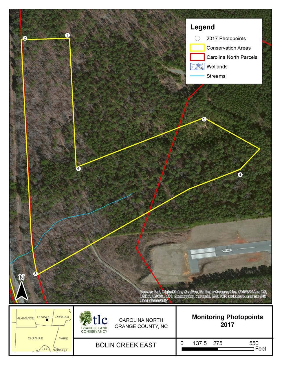
4 Map 4
5 Photo Documentation Table Bolin Creek East Photo Point Photo Number Description Azimuth 1 a Corner 180 b Corner a Corner 80 b Corner a Corner 340 b Corner 30 4 a Corner 220 b Corner 35 5 a Corner 150 b Corner a Corner 50 b Corner 355 5


6 Photopoint 1a: Corner with view south along conservation Photopoint 1b: Corner with view west along conservation Photopoint 2a: Corner with view east along conservation Photopoint 2b: Corner with view south along conservation


7 Photopoint 3a: Corner with view north along conservation Photopoint 3b: Corner with view northeast along Photopoint 4a: Corner with view northeast along Photopoint 4b: Corner with view southwest along


8 Photopoint 5a: Corner with view southeast along Photopoint 5b: Corner with view southwest along Photopoint 6a: Corner with view northeast along Photopoint Corner with view north along conservation area boundary.
Triangle Land Conservancy Conservation Area Monitoring Report Carolina North
 Triangle Land Conservancy Conservation Area Monitoring Report Carolina North Property Name: Crow Branch Conservation Area Date of visit: March 16, 2016 County: Orange Property Type: Restrictive Covenants
Triangle Land Conservancy Conservation Area Monitoring Report Carolina North
 Triangle Land Conservancy Conservation Area Monitoring Report Carolina North Property Name: Bolin Creek West Conservation Area Date of visit: March 16, 2017 County: Orange Property Type: Restrictive Covenants
Triangle Land Conservancy Conservation Area Monitoring Report Carolina North
 Triangle Land Conservancy Conservation Area Monitoring Report Carolina North Property Name: Crow Branch Conservation Area Date of visit: 4/8/2015 County: Orange Property Type: Restrictive Covenants Local
Triangle Land Conservancy Conservation Area Monitoring Report Carolina North
 Triangle Land Conservancy Conservation Area Monitoring Report Carolina North Property Name: Bolin Creek East Conservation Area Date of visit: 4/8/2015 County: Orange Property Type: Restrictive Covenants
DRAFT GENERAL IMPLEMENTATION PLAN AND SPECIFIC IMPLEMENTATION PLAN MIDDLETON MUNICIPAL AIRPORT MOREY FIELD. Revised 12/12/03
 DRAFT GENERAL IMPLEMENTATION PLAN AND SPECIFIC IMPLEMENTATION PLAN MIDDLETON MUNICIPAL AIRPORT MOREY FIELD Revised 12/12/03 As recommended for approval by the Plan Commission General Project Description
MORGAN CREEK GREENWAY Final Report APPENDICES
 APPENDICES MORGAN CREEK GREENWAY Appendix A Photos of Existing Conditions in Trail Corridor Photos of existing conditions Main trail corridor - February 2009 Photos of existing conditions south bank Morgan
Stephens Rd. Nature Preserve
 Stephens Rd. Nature Preserve History Stephens Road Nature Preserve (SRNP) is a 350-acre nature preserve in Huntersville that comprises nine properties purchased between 1994 and 2008. Parcels included
CHAPTER 16 STREETS, SIDEWALKS AND OTHER PUBLIC PLACES*
 CHAPTER 16 STREETS, SIDEWALKS AND OTHER PUBLIC PLACES* *Cross reference(s)--drainage commission, 2-111 et seq.; drainage districts created, 2-114; planning commission shall select and recommend to the
ETOBICOKE CREEK NORTH TRAIL PROJECT. May 18, 2017 at Michael Power High School 105 Eringate Drive, Etobicoke ON M9C 3Z7
 ETOBICOKE CREEK NORTH TRAIL PROJECT May 18, 2017 at Michael Power High School 105 Eringate Drive, Etobicoke ON M9C 3Z7 1 Purpose of Open House The purpose of today s open house is to present the design
Public Notice ISSUED: December 10, 2018 EXPIRES: January 9, 2019
 APPLICANT: REFER TO: St. Louis and Lake Counties Regional Rail Authority 2018-01942-ARC Public Notice ISSUED: December 10, 2018 EXPIRES: January 9, 2019 SECTION:404 - Clean Water Act 1. APPLICATION FOR
Community Development Department Council Chambers, 7:30 PM, July 16, 2015
 STAFF REPORT 2015-25P: Zoning Chapter Amendment Community Development Department Council Chambers, 7:30 PM, July 16, 2015 To: From: Case: Paul Luke, Chairman, Skokie Plan Commission Steve Marciani, Planning
Rule Governing the Designation and Establishment of All-Terrain Vehicle Use Trails on State Land
 Rule Governing the Designation and Establishment of All-Terrain Vehicle Use Trails on State Land 1.0 Authority 1.1 This rule is promulgated pursuant to 23 V.S.A. 3506. Section 3506 (b)(4) states that an
Cultural Resource Management Report Deer Valley 4wd Restoration and Blue Lakes Road Maintenance Project R
 Cultural Resource Management Report R2015-05-03-10005 Undertaking Description: The proposes to perform road maintenance and meadow restoration on the Deer Valley 4wd trail and road maintenance on the Blue
City of Durango 5.8 FUNDING TRAILS DEVELOPMENT
 5.8 FUNDING TRAILS DEVELOPMENT The City has been successful in establishing dedicated local funding sources as well as applying for grants to develop the City s trail system, having received nearly $2.4
Appendix F Public authorities responses
 Planning Proposal under sec 55 of the EP&A Act LEP Refinements Appendix F Public authorities responses Appendix F Public authorities responses Prior to public exhibition, consultation was made with the
COUNCIL OF CECIL COUNTY, MARYLAND DEPARTMENT OF PUBLIC WORKS ROADS DIVISION ADOPT-A-ROAD
 COUNCIL OF CECIL COUNTY, MARYLAND DEPARTMENT OF PUBLIC WORKS ROADS DIVISION ADOPT-A-ROAD 1 CECIL COUNTY ADOPT-A-ROAD PROGRAM Please join us in our Adopt-A-Road Program! Contact the Cecil County Roads Department
Watchorn Provincial Park. Management Plan
 Watchorn Provincial Park Management Plan 2 Watchorn Provincial Park Table of Contents 1. Introduction... 3 2. Park History... 3 3. Park Attributes... 3 3.1 Natural... 4 3.2 Recreational... 4 3.3 Additional
Understanding user expectations And planning for long term sustainability 1
 Understanding user expectations And planning for long term sustainability 1 What is a natural surface trail? It can be as simple has a mineral soil, mulched or graveled pathway, or as developed as elevated
Photopoint Monitoring in the Adirondack Alpine Zone
 Photopoint Monitoring in the Adirondack Alpine Zone Julia Goren (PI) and Seth Jones Adirondack High Peaks Summit Steward Program Adirondack Mountain Club summit@adk.org PO Box 867, Lake Placid, NY 12946
INTRODUCTION. Mailing address: Burke County Community Development Attn: Tim Johnson P. O. Box 219 Morganton, NC
 REQUEST FOR QUALIFICATIONS: PROFESSIONAL, EXPERIENCED TRAIL BUILDERS FOR THE CONSTRUCTION OF THE FONTA FLORA STATE TRAIL LAKE JAMES SECTION BURKE COUNTY COMMUNITY DEVELOPMENT INTRODUCTION Burke County
Greening Project Status Report: Grand Canyon National Park
 Greening Project Status Report: Grand Canyon National Park Prepared for the Federal Energy Management Program U.S. Department of Energy February 2001 iii Contents Page 1. Introduction... 1 2. Context of
Crown Lands and Property Agency. Name Client # LAST (Please Print) FIRST MIDDLE (no initials) Mailing Address. Postal Code
 FIRST MIDDLE (no initials) Mailing Address. Postal Code") Manitoba Conservation and Water Stewardship Application for Permit/Lease/Purchase/Easement/Exchange/Licence of Occupation (under The Crown Lands Act c.c340) Please check one ( ) Permit Lease Purchase Easement
Manitoba Conservation and Water Stewardship Application for Permit/Lease/Purchase/Easement/Exchange/Licence of Occupation (under The Crown Lands Act c.c340) Please check one ( ) Permit Lease Purchase Easement
Proposed Official Plan Amendment 41 to the Region of York Official Plan
 COMMITTEE OF THE WHOLE NOVEMBER 18, 2002 REGION OF YORK OFFICIAL PLAN AMENDMENT 41 THE OAK RIDGES MORAINE CONSERVATION PLAN Recommendation The Commissioner of Planning recommends: 1. That the City of Vaughan
Logo Department Name Agency Organization Organization Address Information 5700 North Sabino Canyon Road
 Logo Department Name Agency Organization Organization Address Information United States Forest Coronado National Forest 5700 North Sabino Canyon Road Department of Service Santa Catalina Ranger District
APPLICATION FOR TENTS/INFLATABLES
 APPLICATION FOR TENTS/INFLATABLES City of Johnson City Codes Division 601 East Main Street Johnson City, TN 37601 (423) 434-6047 TENT SECTION Approval Date: Application No: Date Issued: Permit Fee: Expiration
Greenways Commission Meeting Agenda Monday, March 20, 2017; 4:00 pm 7:00 pm Town Hall, Parking Lot
 Greenways Commission Meeting Agenda Monday, March 20, 2017; 4:00 pm 7:00 pm Town Hall, Parking Lot I. 4:00 4:05 pm Leave Town Hall Parking Lot for Briar Chapel II. III. IV. 4:30 pm Site Visit - Briar Chapel
ARKANSAS HEADWATERS RECREATION AREA SPECIAL USE AGREEMENT RIDER ROCK CLIMBING, HIKING & MT. BIKING
 ARKANSAS HEADWATERS RECREATION AREA SPECIAL USE AGREEMENT RIDER ROCK CLIMBING, HIKING & MT. BIKING PURPOSE OF RIDER: To authorize Company Legal operating as Company dba the following activities for 2018
Short-Term Rentals Public Input. Thursday, November 5, 2015
 Short-Term Rentals Public Input Thursday, November 5, 2015 Outline City s timeline Survey results Other agencies comments Taxes Lodging numbers Other cities Q&A and/or discussion groups City s Timeline
Order of the Minister of Environment #39, August 22, 2011 Tbilisi
 Registration Code 360050000.22.023.016080 Order of the Minister of Environment #39, August 22, 2011 Tbilisi On preparatory stages and procedure of the methodology for Elaborating structure, content and
ORDINANCE NO. 510 THEREFORE, BE IT ORDAINED BY THE GOVERNING BODY OF THE CITY OF BEL AIRE, KANSAS:
 (Published in The Ark Valley News on July, 2012.) ORDINANCE NO. 510 S-I-1 GILMORE & BELL, P.C. 07/11/2012 AN ORDINANCE CREATING A COMMUNITY IMPROVEMENT DISTRICT IN THE CITY OF BEL AIRE, KANSAS; AUTHORIZING
Ditch flows slowly to the north
 Ditch flows slowly to the north Photo 1. Wetland DE: Looking west across Wetland DE from upslope. Ponded water, mucky mineral soils, and patches of emergent vegetation observed. Wetland DE appears to be
TABLE OF CONTENTS 1.0 INTRODUCTION...
 Staff Instruction Subject: Eligibility of American and Mexican Registered Aircraft for Operation Under the North American Issuing Office: Standards Activity Area: Qualifying Document No.: SI 500-005 File
Alternative 3 Prohibit Road Construction, Reconstruction, and Timber Harvest Except for Stewardship Purposes B Within Inventoried Roadless Areas
 Roadless Area Conservation FEIS Summary Table S-1. Comparison of Key Characteristics and Effects by Prohibition Alternative. The effects summarized in this table A would occur in inventoried roadless areas
Francis Marion and Sumter National Forests
 United States Department of Agriculture Forest Service Francis Marion and Sumter National Forests 2967 Steed Creek Rd. Huger, SC 29450 Tele: (843)336-2200 File Code: 1950 Date: February 13, 2015 To Whom
State Environmental Planning Policy (Sydney Region Growth Centres) Amendment (Catherine Fields Precinct) 2013
 Amendment (Catherine Fields Precinct) 2013") New South Wales (Sydney Region Growth Centres) Amendment (Catherine Fields Precinct) 2013 under the Environmental Planning and Assessment Act 1979 Her Excellency the Governor, with the advice of the Executive
New South Wales (Sydney Region Growth Centres) Amendment (Catherine Fields Precinct) 2013 under the Environmental Planning and Assessment Act 1979 Her Excellency the Governor, with the advice of the Executive
Building Permit Application
 Building Permit Application Co-Owner Name Lot # Address City State Zip Phone (home) (cell) Contractor (if applicable) The above named co-owner hereby makes application to Cedar Shores Campground Condominium
Table of Contents TABLE OF CONTENTS. HOW THIS BY-LAW WORKS... i PART 1 - ADMINISTRATION, INTERPRETATION, ENFORCEMENT, AND DEFINITIONS
 TABLE OF CONTENTS Page Number HOW THIS BY-LAW WORKS... i PART 1 - ADMINISTRATION, INTERPRETATION, ENFORCEMENT, AND DEFINITIONS 1.1 ADMINISTRATION, INTERPRETATION AND ENFORCEMENT... 1.1 ~ 1 to 6 1.1.1 Within
The Summit County Open Space and Trails Regulations
 The Summit County Open Space and Trails Regulations ADOPTED PURSUANT TO RESOLUTION NO. 2007-59 ON AUGUST 14, 2007 AMENDED PURSUANT TO RESOLUTION NO. 2015-55 ON OCTOBER 16, 2015 Section 1. Intent The Summit
Summary of prescribed fires in Prince Albert National Park 2015
 Summary of prescribed fires in Prince Albert National Park 2015 Prince Albert National Park conducted four controlled fires in spring 2015, plus an additional fire in October. Fuel Management for Hazard
VoIP RADIO CONSOLE SYSTEM FOR MACON COUNTY EMERGENCY MANAGEMENT
 REQUEST FOR BIDS AND PROPOSALS BID REQUEST NO. 4375-02 VoIP RADIO CONSOLE SYSTEM FOR MACON COUNTY EMERGENCY MANAGEMENT ISSUE DATE: December 23, 2011 BID OPENING DATE: JANUARY 11, 2012 3:00 PM LOCAL TIME
Fossil Creek Wild & Scenic River Comprehensive River Management Plan Forest Service Proposed Action - details March 28, 2011
 Fossil Creek Wild & Scenic River Comprehensive River Management Plan Forest Service Proposed Action - details March 28, 2011 Primary Goals of the Proposed Action 1. Maintain or enhance ORVs primarily by
Phoenix Habitat Restoration Projects
 Phoenix Habitat Restoration Projects Spur Cross Ranch Cave Creek (Estergard) Regional Tree and Shade Summit March 9, 2010 Desert Riparian Ecosystems Healthy riparian areas like this once existed along
STEPS REQUIRED TO OBTAIN A BUILDING PERMIT. 1. Obtain copy of Building Guidelines for River Ridge and Building Permit application.
 STEPS REQUIRED TO OBTAIN A BUILDING PERMIT 1. Obtain copy of Building Guidelines for River Ridge and Building Permit application. 2. Obtain copy of your plat. MARK ALL PROPERTY LINES. 3. Turn your completed
GCAA GUYANA CIVIL AVIATION AUTHORITY
 GCAA GUYANA CIVIL AVIATION AUTHORITY DIRECTIVE No: GCAA/ASR/DIR/2017-01 Issued: 26 th February, 2017 AUTHORITY DIRECTIVE TO OWNERS AND OPERATORS OF UNMANNED AERIAL VEHICLES (UAVs) The Guyana Civil Aviation
Lake Wissota Access Locations within the LaFayette Township. By Chad Martin
 Lake Wissota Access Locations within the LaFayette Township By Chad Martin Anson/ Wissota Access Point # 1 Road: 195 th St. Associated Fire Numbers: 13294 Defining Characteristics: Forested from road
EXPERIMENTAL OPERATING LIMITATIONS EXHIBITION GROUP I1
 US. Department of Transportatlon Federal Aviation Administration MA[. 2 3 2000 Flight Standards District Office EXPERIMENTAL OPERATING LIMITATIONS EXHIBITION GROUP I1 Registration No:N7237K Make:Bell Model:206A-l
County of Riverside - PSEC Project General Habitat Assessment Appendix A
 County of Riverside - PSEC Project General Habitat Assessment Appendix A Lake Elsinore Lake Elsinore The Lake Elsinore study area is located in the hills directly adjacent to Lake Elsinore, in the City
National Recreation Trail Update Form
 National Recreation Trail Update Form Introduction Thank you for taking the time to complete this form. Your assistance will help ensure that the National Recreation Trail (NRT) database is complete and
PLANNING BOARD MINUTES March 13, 2017 CASCO COMMUNITY CENTER 7:00 P.M. MEMBERS PRESENT: Stan Buchanan, Ray Grant & Lynne Potter Bob Barnes, Ted
 PLANNING BOARD MINUTES March 13, 2017 CASCO COMMUNITY CENTER 7:00 P.M. MEMBERS PRESENT: Stan Buchanan, Ray Grant & Lynne Potter MEMBERS ABSENT: Bob Barnes, Ted Beckner & Jim Macklin STAFF PRESENT: James
Finn Creek Park. Management Direction Statement Amendment
 Finn Creek Park Management Direction Statement Amendment November 2013 Management Direction Statement Amendment Approved by: Jeff Leahy Regional Director, Thompson Cariboo BC Parks November 12, 2013 Date
BRACEVILLE NATURE PRESERVE Introductions History Present Conditions Future Development Plans Implementation Strategies Statistics
 BRACEVILLE NATURE PRESERVE Introductions History Present Conditions Future Development Plans Implementation Strategies Statistics Introduction Braceville Nature Preserve is one of MetroParks largest preserves.
CITY COUNCIL AGENDA MEMORANDUM
 To: Mayor and City Council From: Charles Ozaki, City and County Manager Prepared By: Kevin Standbridge, Deputy City and County Manager Katie Allen, City and County Engineer David Shinneman, Community Development
City of Surrey PLANNING & DEVELOPMENT REPORT File:
 City of Surrey PLANNING & DEVELOPMENT REPORT File: 7917-0297-00 Planning Report Date: September 11, 2017 PROPOSAL: Amend CD By-law No. 18795 (based on RH-G). to allow for an increased house size on thirteen
[Docket No. FAA ; Product Identifier 2017-CE-022-AD] AGENCY: Federal Aviation Administration (FAA), Department of Transportation
![[Docket No. FAA ; Product Identifier 2017-CE-022-AD] AGENCY: Federal Aviation Administration (FAA), Department of Transportation](/thumbs/88/116055228.jpg "[Docket No. FAA ; Product Identifier 2017-CE-022-AD] AGENCY: Federal Aviation Administration (FAA), Department of Transportation") This document is scheduled to be published in the Federal Register on 03/13/2018 and available online at https://federalregister.gov/d/2018-05012, and on FDsys.gov [4910-13-P] DEPARTMENT OF TRANSPORTATION
This document is scheduled to be published in the Federal Register on 03/13/2018 and available online at https://federalregister.gov/d/2018-05012, and on FDsys.gov [4910-13-P] DEPARTMENT OF TRANSPORTATION
For questions about this policy, please contact the Office of the Vice President for Research and Innovation at
 POLICY 0.00.00 UNMANNED AIRCRAFT SYSTEMS POLICY [DRAFT] Reason for Policy The purpose of this Policy is to facilitate the operation of unmanned aircraft systems ( UAS ) and model aircraft for teaching
ARTICLE 7 MOBILE HOME AND RECREATIONAL VEHICLE PARKS AND CAMPGROUNDS
 ARTICLE 7 MOBILE HOME AND RECREATIONAL VEHICLE PARKS AND CAMPGROUNDS Section 701. APPLICABILITY Where a municipality has no subdivision or land development ordinance the provisions of this article shall
THE ALBERTA GAZETTE, SEPTEMBER
 VILLAGE OF CEREAL Order No. 16915 IN THE MATTER OF THE "Municipal Government Act": File No. 241(A)3 AND IN THE MATTER OF an application by the Council of the Village of Cereal, in the Province of Alberta,
National Forests in North Carolina Pisgah National Forest Appalachian Ranger District Burnsville Station
 United States Department of Agriculture Forest Service National Forests in North Carolina Pisgah National Forest Appalachian Ranger District Burnsville Station PO Box 128 US Bypass 19 Burnsville, NC 28714-0128
RIVERDALE CITY CITY COUNCIL AGENDA January 20, 2009 AGENDA ITEM:
 RIVERDALE CITY CITY COUNCIL AGENDA January 20, 2009 AGENDA ITEM: G3 SUBJECT: Consideration of Ordinance #728 adopting a new Chapter under Title 4, Public Health and Safety, Chapter 5b, Camping. PETITIONER:
CITY OF MURFREESBORO BOARD OF ZONING APPEALS
 CITY OF MURFREESBORO BOARD OF ZONING APPEALS Regular Meeting, April 28, 2010, at 1:00 p.m. City Hall, 111 West Vine Street, Council Chambers, 1 st Floor 1. Call to order A G E N D A 2. Consideration of
ROAD AND TRAIL PROJECT APPROVAL
 ROAD AND TRAIL PROJECT APPROVAL www.marincountyparks.org Marin County Parks, 3501 Civic Center Dr, Suite 260, San Rafael, CA 94903 DATE: July 12, 2017 PRESERVE: Gary Giacomini Open Space Preserve PROJECT:
TOWN OF SWANSBORO Planning Board Regular Meeting Community Room AGENDA
 TOWN OF SWANSBORO Planning Board Regular Meeting Community Room April 4, 2016 Monday 6:00 pm Town Hall 601 W. Corbett Ave. AGENDA 1. Call to Order 2. Roll Call and Quorum Verification 3. Approval of Meeting
Chair and Members, The Etobicoke York Community Council. Mark Sraga, Director and Deputy Chief Building Official
 STAFF REPORT ACTION REQUIRED Sign Variance Report - Revised 29 Algie Avenue Date: January 11, 2010 To: From: Chair and Members, The Etobicoke York Community Council Mark Sraga, Director and Deputy Chief
THAT the Board approve the final proposed concept plan for the Jericho Marginal Wharf site as shown in Figure C-4 of Appendix C.
 Date: January 17, 2012 TO: Board Members Vancouver Park Board FROM: General Manager Parks and Recreation SUBJECT: Jericho Marginal Wharf Phase 2 Concept Plan RECOMMENDATION THAT the Board approve the final
IN THE CHANCERY COURT OF LAMAR COUNTY, MISSISSIPPI CIVIL ACTION NO.: CITY OF HATTIESBURG, MISSISSIPPI
 IN THE CHANCERY COURT OF LAMAR COUNTY, MISSISSIPPI IN THE MATTER OF THE INCORPORATION OF THE CITY OF BELLEVUE, MISSISSIPPI, BELLEVUE INCORPORATORS VS. CITY OF HATTIESBURG, MISSISSIPPI PETITIONERS CIVIL
Coronado National Forest Santa Catalina Ranger District
 United States Department of Agriculture Forest Service Coronado National Forest Santa Catalina Ranger District File Code: 1950 Date: October 14, 2015 Dear Interested Party: The Santa Catalina Ranger District
Administration Policies & Procedures Section Commercial Ground Transportation Regulation
 OBJECTIVE METHOD OF OPERATION Definitions To promote and enhance the quality of Commercial Ground Transportation, the public convenience, the safe and efficient movement of passengers and their luggage
HILLBILLY DAYS 2015 APPLICATION
 HILLBILLY DAYS 2015 APPLICATION Hillbilly Days 2015 April 16-18, 2015 Southeast Kentucky Chamber of Commerce Application 178 College Street Email: info@sekchamber.com Pikeville, KY 41501 Phone: 606-432-5504
Daisy Dean Trail 628/619 ATV Trail Construction
 Background and Purpose and Need The Daisy Dean ATV Trail Construction Project is located in the Little Belt Mountains, Musselshell Ranger District, Lewis and Clark National Forest approximately 32 miles
FIGURES. Former Hoppy s Paint & Body and Knat s Barber Shop City of Plant City. CSI Job No C
 FIGURES Former Hoppy s Paint & Body and Knat s Barber Shop City of Plant City CSI Job No. 9680.33 C INFERRED EXTENT OF ARSENIC IMPACTED SOIL C.A. No. 262 Additional Soil Assessment Activities 607, 609,
UNITED STATES DEPARTMENT OF THE INTERIOR BUREAU OF LAND MANAGEMENT MANUAL TRANSMITTAL SHEET
 Form 1221-2 (June 1969) UNITED STATES DEPARTMENT OF THE INTERIOR BUREAU OF LAND MANAGEMENT MANUAL TRANSMITTAL SHEET Release 8-83 Date Subject 8353 Trail Management Areas Secretarially Designated (Public)
National Wilderness Steering Committee
 National Wilderness Steering Committee Guidance White Paper Number 1 Issue: Cultural Resources and Wilderness Date: November 30, 2002 Introduction to the Issue Two of the purposes of the National Wilderness
Section 61 Recreational Vehicle Park / Campground (Bylaw No. 2012/10)
") Part 7 General Regulations Section 61 Recreational Vehicle Park / Campground (Bylaw No. 2012/10) 61.1 A comprehensive site plan shall be provided to the satisfaction of the Development Authority that shows
Part 7 General Regulations Section 61 Recreational Vehicle Park / Campground (Bylaw No. 2012/10) 61.1 A comprehensive site plan shall be provided to the satisfaction of the Development Authority that shows
METROPOLITAN COUNCIL 390 North Robert Street, St. Paul, MN Phone (651) TDD (651)
 TDD (651)") DATE: March 27, 2012 METROPOLITAN COUNCIL 390 North Robert Street, St. Paul, MN 55101 Phone (651) 602-1000 TDD (651) 291-0904 TO: Metropolitan Parks and Open Space Commission FROM: Arne Stefferud, Planning
DATE: March 27, 2012 METROPOLITAN COUNCIL 390 North Robert Street, St. Paul, MN 55101 Phone (651) 602-1000 TDD (651) 291-0904 TO: Metropolitan Parks and Open Space Commission FROM: Arne Stefferud, Planning
The Corporation of the Township of Wollaston By-law Being a by-law to licence recreational vehicles and tents in the Township of Wollaston
 By-law 38-17 Being a by-law to licence recreational vehicles and tents in the Township of Wollaston WHEREAS Section 164 of the Municipal Act, 2001 as amended, authorizes the municipality to prohibit or
ORDER CALLING PUBLIC HEARING TOBE HELD ON MARCH 2, 2016
 A regular meeting of the Town Board of the Town of New Windsor, in the County of Orange, New York, was held at the Town Hall, in said Town, on the 3rd day of February, 2016. PRESENT: George A. Green, Supervisor
Kansas (KAW) River History
 River History") Kansas (KAW) River History The first map of the Kansas River is dated back to 1718. Lewis and Clark spent 3 days camped at Kaw Point at the confluence of the Kansas and Missouri Rivers. Kansas (KAW) River
Kansas (KAW) River History The first map of the Kansas River is dated back to 1718. Lewis and Clark spent 3 days camped at Kaw Point at the confluence of the Kansas and Missouri Rivers. Kansas (KAW) River
San Juan Resource Area Recreation Impact Inventory/Monitoring
 San Juan Resource Area Recreation Impact Inventory/Monitoring Indian Creek Climbing Area Overview & Summary of Findings 2007 Pam Foti, Professor Aaron Divine, Lecturer Janet Lynn, Program Coordinator Northern
CARVER S FALLS. Cumberland County s Natural Beauty. What s Included In This Information Packette
 Cumberland County s Natural Beauty What s Included In This Information Packette History of the Falls Boy Scouts have acquired Right of Use Guidelines for Usage Application Check-out Report HISTORY AND
M E M O R A N D U M. Status of the Environmental Cleanup of the Shipyard
 ECONOMIC AND WORKFORCE DEVELOPMENT MICHAEL COHEN, DIRECTOR CITY AND COUNTY OF SAN FRANCISCO GAVIN NEWSOM, MAYOR M E M O R A N D U M TO: Members of the Health Commission FROM: Michael Cohen CC: Mitch Katz,
Tourism Impacts and Second Home Development in Pender County: A Sustainable Approach
 Tourism Impacts and Second Home Development in Pender County: A Sustainable Approach (Funded by North Carolina Sea Grant) Center for Sustainable Tourism Division of Research and Graduate Studies East Carolina
Table 1: Iron Mountain Communication Site. Latitude 1 Longitude 1 Elev 2 Address T/R/S 3 APN 4 USGS Quadrangle
 County of Riverside Public Safety Enterprise Communication Project Appendix A: Candidate Site Descriptions Overview The site is located in San Bernardino County near several communication towers in the
Airport Land Use Compatibility Plan (ALUCP) Update. Public Information Meeting #4 June 8 & 9, 2016
 Update. Public Information Meeting #4 June 8 & 9, 2016") Airport Land Use Compatibility Plan (ALUCP) Update Public Information Meeting #4 June 8 & 9, 2016 Agenda 1. Study Process 2. Noise Complaint Patterns 3. Proposed Overflight Areas (AOA) 4. Proposed Land
Airport Land Use Compatibility Plan (ALUCP) Update Public Information Meeting #4 June 8 & 9, 2016 Agenda 1. Study Process 2. Noise Complaint Patterns 3. Proposed Overflight Areas (AOA) 4. Proposed Land
AIRPORT EMERGENCY CONTINGENCY PLAN TEMPLATE V 3.3 April 27, 2012
 AIRPORT EMERGENCY CONTINGENCY PLAN TEMPLATE V 3.3 April 27, 2012 Section 42301 of the FAA Modernization and Reform Act of 2012 1 (the Act) requires airport operators to submit emergency contingency plans
BARODA TOWNSHIP OPEN BURNING ORDINANCE. Ordinance No. 35
 BARODA TOWNSHIP OPEN BURNING ORDINANCE Ordinance No. 35 TABLE OF CONTENTS Section 1: Authority. 2 Section 2: Purpose...2 Section 3: Applicability......2 Section 4: Definitions...2 Section 5: Open burning
Santa Clara South Hills Recreation Park Project Development and Management Plan
 Santa Clara South Hills Recreation Park Project Application for Land for Recreation or Public Purposes, City of Santa Clara, Utah Prepared for: Bureau of Land Management, St. George Field Office 345 East
Administration Policies & Procedures Section Commercial Ground Transportation Regulation
 OBJECTIVE METHOD OF OPERATION Definitions To promote and enhance the quality of Commercial Ground Transportation, the public convenience, the safe and efficient movement of passengers and their luggage
PLANNING COMMISSION AGENDA REPORT May 10, Members of the Planning Commission. Joyce Parker-Bozylinski, Contract Planner
 PLANNING COMMISSION AGENDA REPORT May 10, 2007 TO: FROM: PROPOSAL: APPLICANT: RECOMMENDATION: Members of the Planning Commission Joyce Parker-Bozylinski, Contract Planner Approval of the Calabasas Trails
A GUIDE TO MANITOBA PROTECTED AREAS & LANDS PROTECTION
 A GUIDE TO MANITOBA PROTECTED AREAS & LANDS PROTECTION Manitoba Wildands December 2008 Discussions about the establishment of protected lands need to be clear about the definition of protection. We will
Numaykoos Lake Provincial Park. Management Plan
 Numaykoos Lake Provincial Park Management Plan 2 Numaykoos Lake Provincial Park Table of Contents 1. Introduction... 3 2. Background... 3 3. Park Purpose... 5 4. Park Management Guidelines... 6 Appendix...
FIRE Equipment Fire Training Equipment 105, , Total of Equipment 105, ,
 FIRE Equipment Fire Training Equipment 105,000-105,000 - - - - - - - - - - Total of Equipment 105,000-105,000 - - - - - - - - - - Fire Apparatus Aerial Ladder Replacement 5,320,000 1,120,000 - - 1,400,000
APPENDIX F List of Commitments
 APPENDIX F List of Commitments s Table F.1 Standard Mitigation Measures Mitigation Measure MnDOT Specification Number Status Update Description Status Update Utilities Provide early notice to utility operators
BAXTER LAKE RECREATION AREA ASSOCIATION
 Baxter Lake Recreation Area Association SITE CONTROL COMMITTEE RULES TABLE OF CONTENTS Notes 2 Introduction 2 Campsites 2 Common Grounds 2 Green Areas 2 Cutting Trees 3 Application for Site Alteration
Trappist Monastery Provincial Park. Management Plan
 Trappist Monastery Provincial Park Management Plan 2 Trappist Monastery Provincial Park Table of Contents 1. Introduction... 3 2. Park History... 3 3. Park Attributes... 4 3.1 Natural... 4 3.2 Recreational...
PROVINCE OF BRITISH COLUMBIA ORDER OF THE LIEUTENANT GOVERNOR IN COUNCIL. Pres
 PROVINCE OF BRITISH COLUMBIA ORDER OF THE LIEUTENANT GOVERNOR IN COUNCIL Order in Council Al;-:, Approved and Ordered juti 0 ZOCA Executive Council Chambers, Victoria Lieutenant Governor On the recommendation
Gravel and Rock Extraction Highway Maintenance, Recapitalization and Twinning
 Gravel and Rock Extraction Highway Maintenance, Recapitalization and Twinning Backgrounder: Mountain National Parks A Need for Change Existing supplies of aggregate (sand and gravel) for highway maintenance,
HIGHWAY TRAFFIC BOARD DECISION. File Number: Alsask Bus Services Ltd. of Alsask, Saskatchewan
 HIGHWAY TRAFFIC BOARD DECISION File Number: 11-14 Alsask Bus Services Ltd. of Alsask, Saskatchewan IN THE MATTER of an application for an amendment to Operating Authority Certificate #7874 filed by Alsask
DEVELOPMENT PLAN REVIEW PROCESS and APPLICANT GUIDELINES
 DEVELOPMENT PLAN REVIEW PROCESS and APPLICANT GUIDELINES DEVELOPMENT DEPARTMENT 120 Gary Wade Boulevard Sevierville, TN 37862 (865) 453-5504 seviervilletn.org Pamela S. Caskie, Development Director Judith
b. Minimum Site Area. Recreational vehicle parks shall be located on a parcel of land not less than 3 acres in area.
 6450 RECREATIONAL VEHICLE PARK REGULATIONS 6450 TITLE AND PURPOSE. The provisions of Section 6450 through 6499, inclusive, shall be known as the Recreational Vehicle Park Regulations. The purpose of these
THREE MILE PLAN TOWN OF SUPERIOR COLORADO
 THREE MILE PLAN TOWN OF SUPERIOR COLORADO February 23, 2015 INTRODUCTION This document has been prepared by the Town of Superior, Colorado, to address the existing and proposed land uses within an approximate