Guadalupe Delta Log Jam History & GBRA Operations in the Lower Basin. March 23, 2017
|
|
|
- Marjory Jean Wilcox
- 5 years ago
- Views:
Transcription
1 Guadalupe Delta Log Jam History & GBRA Operations in the Lower Basin March 23, 2017
2 Guadalupe Watershed Geographic Regions
3 Guadalupe Watershed Geographic Regions Flat
4 Delta Geomorphology Upper Delta Middle Delta Lower Delta
5 Delta Geomorphology Upper Delta Middle Delta Lower Delta Major Log Jams

6 Delta Inferred Development of Delta

7 Delta Inferred Development of Delta

8 Delta Inferred Development of Delta
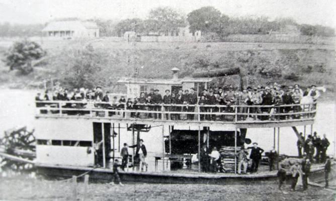


9 History Steam-Boat Traffic
10 Delta History Log Jams 1848 Newspaper discuss Steamboat Traffic logs were issue st Navigation Project awards to GB Dycus to remove jams To removal log below City of Victoria Funding by City County - State of $22, Railroad built and provides completion 1860s Civil War interrupted Navigation 1875 Chief Report by COE discuss large jams 1880 Fritz Berner Barges freights but logs are issue 1890 Sand & Gravel Company start barging operation 1907 River & Harbor Act (1907) Clears Channel to Victoria

11 Delta History COE Report Excerpts from: THE ANNUAL REPORT OF THE CHIEF OF ENGINEERS TO THE SECRETARY OF WAR FOR THE YEAR 1875 EXAMINATION OF THE GUADALUPE RIVER BELOW GONZALES, TEXAS JULY THRU SEPTEMBER 1874 The character of and the obstr uctions in the r iver between Gonzales and its mouth may be considered to consist of two: the f i r s t, t hat par t between Gonzales and a point three miles below Vi ctor i a i n which the average cur rent is a bout three miles per hour and the average depth a bout 8 feet For the second par t, from the one hundred and sixth mile to the mouth below Vi ctor i a, the character of the r i ver is somewhat different, the average cur rent being one and one -four th miles per hour and in the neighborhood of the rafts (log jams) scarcely perceptible
12 Delta History COE Report In the lower part of the river (below Victoria), the principal obstructions are the rafts (log jams), of which there are four; the first of which completely blocks the river for a distance of 1,850 feet The first of these rafts is a bad obstruction, and would be difficult of removal, being composed of several layers of heavy trees wedged together and into the banks and bed of the river, the whole forming a compact mass some 12 feet in depth.

")
13 Delta History Snag Boat (1910)

14 Delta History Snag Boat (1910)
15 Delta History Log Jams 1945 River & Harbor Act (1945) Proposes Barge Canal to avoid logs 1951 Victoria Barge Canal Construction Begins on 14 miles 1953 Victoria Barge Canal -1 st Phase complete 1965 Canal at Turning Basin Complete Docks at Turning Basin Complete


16 Delta History Victoria Barge Canal

17 Victoria Barge Canal at Green Lake (Flood of 1998)
18 Delta Recent History Log Jams 1963 GBRA purchases Calhoun Canal System 1963 GBRA encourages log jam removal Rep. John Young recommends COE clearing jams & tree for 7.5miles 1975 COE obtains funding to clear log on Guadalupe River 1976 GBRA constructs boat to remove small jams on Guadalupe 2009 GBRA constructs 2 nd vessel

19 Guadalupe River at Horseshoe Causes of Log Jam Erosion causes trees to fall into river Slower river velocity Obstructions

20 Delta Log Jam History


21 Two vessels working in tandem to break-up Jam

22 Miss Guadalupe II track hoe breaks up key logs

23 Logs retrieved from river & stacked on bank

24 Stacks burned in place

25 River Conditions Dictate Opportunity for Removal Optimal Conditions for Log jam Removal Operations 2 0
26 Recent Major Log Jam Removal Projects COE Guadalupe River (selected areas -river mile 3 to 19) In 1963, GBRA Provide letter to Congress requesting COE funding NRCS Guadalupe & San Antonio River Funding provided as a result of 1998 Flood Event GBRA San Antonio River Project (River Mile 6 to 8) GBRA used In-House Personal NRCS San Antonio River Project (River Mile 6 to 9) NRCS Funded project
27 COE -Log-jam Removal Project Victoria Barge Canal Union Pacific Railroad Bridge Guadalupe River Location of primary by-pass box Victoria Barge Canal Hwy 77 & Union Pacific Bridges San Antonio River Location of secondary by pass box where flap gate will be installed. Concrete Bridge Elm Bayou Salt Water Barrier GREEN LAKE


28 Guadalupe River COE Project
29 NRCS Log-jam Removal Project 1999 Victoria Barge Canal Union Pacific Railroad Bridge Guadalupe River Location of primary by-pass box Victoria Barge Canal Hwy 77 & Union Pacific Bridges San Antonio River Location of secondary by pass box where flap gate will be installed. Concrete Bridge Elm Bayou Salt Water Barrier GREEN LAKE

30 Guadalupe & San Antonio River NRCS Project 1999

31 Guadalupe & San Antonio River NRCS Project 1999


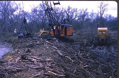
32 San Antonio River Debris Removal Project 2008


33 San Antonio River Debris Removal Project

34 San Antonio River required track-hoe and bull dozer -2008

35 Logs stacked and burned later (2009)


36 Intersection San Antonio River & Elms Bayou San Antonio River Elm Bayou

37 San Antonio River Mile
38 San Antonio River Debris Removal Project NRCS Victoria Barge Canal Union Pacific Railroad Bridge Guadalupe River Location of primary by-pass box Victoria Barge Canal Hwy 77 & Union Pacific Bridges San Antonio River Location of secondary by pass box where flap gate will be installed. Concrete Bridge Elm Bayou Salt Water Barrier GREEN LAKE

39 San Antonio River Debris Removal Project 2016 Composite Map Jim Fagan Bridge Roger Fagan Bridge San Antonio River Debris Removal Composite Location Map Log Jam Locations

40 San Antonio River Debris Removal Project 2016 Upstream Jim & Ginger Fagan Bridge Pre-Construction Site 20

41 San Antonio River Debris Removal Project 2016 Working at Site 20

42 San Antonio River Debris Removal Project 2016 Pre-Construction Site 13

43 San Antonio River Debris Removal Project 2016 Working at Site 13

44 San Antonio River Debris Removal Project 2016 Working at Site 02

45 Migration San Antonio River channel Present
46 Jonathan D. Phillips

47 San Antonio River Sedimentation ft increase over last 30 years

48 San Antonio River during drought Location of primary bypass box Location of secondary by pass box where flap gate will be installed.
MARCH 2014 HYDROGRAPHIC REPORT
 DEPARTMENT OF THE ARMY GALVESTON DISTRICT, CORPS OF ENGINEERS P.O. BOX 1229 GALVESTON, TEXAS 77553-1229 MARCH 2014 HYDROGRAPHIC REPORT CHANNELS WITH PROJECT DEPTHS 25 FEET OR OVER A report of the depths
Damn those dams their effects on stream ecosystems
 Damn those dams their effects on stream ecosystems Jeremy Tiemann Illinois Natural History Survey Prairie Research Institute at the University of Illinois History of dams History of dams First evidence
The Mississippi River Commission. History of the Management of the Mississippi River. US Army Corps of Engineers BUILDING STRONG
 The Mississippi River Commission History of the Management of the Mississippi River US Army Corps of Engineers US Army Corps of Engineers Presentation Outline Overview of Mississippi River History of Mississippi
Northern Rail Extension, Phase One
 General Project and Funding 1. Where does Phase One start? The rail line for Phase One begins roughly at the northern boundary of the former Bradbury property, but also includes work along Tom Bear Trail
Design and Construction of the Lake St. Martin Emergency Outlet
 Design and Construction of the Lake St. Martin Emergency Outlet Background 2011 was the largest flood event experienced in the last 200 years Flood Fighting required some difficult decisions by the Manitoba
Ohio Freight Conference Great Lakes Commercial Navigation
 Ohio Freight Conference Great Lakes Commercial Navigation Roger E. Haberly Regional Economist Buffalo New York 13 September 2013 US Army Corps of Engineers Presentation Overview 1. GL Physical System Description
Sandbag Barrier. Suitable Applications Sandbag barriers may be suitable: As a linear sediment control measure:
 Categories EC Erosion Control SE Sediment Control TC Tracking Control WE Wind Erosion Control Non-Stormwater NS Management Control Waste Management and WM Materials Pollution Control Legend: Primary Category
2012 Texas Water Conservation Association Meeting
 2012 Texas Water Conservation Association Meeting BG Thomas Kula Southwestern Division Commander 15 June 2012 US Army Corps of Engineers AGENDA UNCLASSIFIED Overview of Southwestern Division Missions Texas
HARBOR INFRASTRUCTURE INVENTORIES Buffalo Harbor, New York
 HARBOR INFRASTRUCTURE INVENTORIES Buffalo Harbor, New York Harbor Location: Buffalo Harbor is located on the Eastern shore of Lake Erie in the City of Buffalo, NY. Authority: River & Harbor Acts of 1826,
APPENDIX D: SUSTAINABLE TRAIL DESIGN. APPENDICES Town of Chili Parks and Recreation Master Plan Update
 APPENDIX D: SUSTAINABLE TRAIL DESIGN APPENDICES Town of Chili Parks and Recreation Master Plan Update Sustainable Trail Construction Sustainable trails are defined by the US Forest Service as trails having
CORPS OF ENGINEERS ALASKA DISTRICT Dredging Projects. Michael Tencza, PE Operations Project Manager November 4, 2015
 CORPS OF ENGINEERS ALASKA DISTRICT 2016 Dredging Projects Michael Tencza, PE Operations Project Manager November 4, 2015 US Army Corps of Engineers Building and Preserving Alaska s Future AWARDED CONTRACTS
Waterways and Floods. by Michael Pearce. Smith-Layton Archive. Sponsored by Linda L. Lester
 Smith-Layton Archive Waterways and Floods Charlene Duval, Executive Secretary cduval@sourisseauacademy.org Leilani Marshall, Archivist lmarshall@sourisseauacademy.org by Michael Pearce Phone: 408 808-2064
Non-motorized Trail Plan & Proposal. August 8, 2014
 Town of Star Valley Ranch, Wyoming and the Star Valley Ranch Association in partnership with the USDA Forest Service, Bridger-Teton National Forest, Greys River Ranger District Non-motorized Trail Plan
The Holes Creek Bridge Replacement By Bradley McClelland
 The Holes Creek Bridge Replacement By Bradley McClelland Each time there is a heavy rainstorm, the folks along Sheffield Road in the Dayton, Ohio suburb of West Carrollton have cause to be concerned. Holes
Page 1 (CMMP TAB 1-1)
") Upper Mississippi River System Navigation Projects St. Paul District Location and Authorized Dimensions Location Dimensions (FT) Distance Project Pool(s) River Miles Cities Width Depth Miles Channels Upper
Upper Mississippi River System Navigation Projects St. Paul District Location and Authorized Dimensions Location Dimensions (FT) Distance Project Pool(s) River Miles Cities Width Depth Miles Channels Upper
Presentation Overview
 DON NARROWS Historical and Existing Conditions March 29, 2008 Presentation Overview 1. Project Location and Background 2. Historical Context How did the Don Narrows Come to Be? 3. The Today 4. Next Steps
TRINITY RIVER CORRIDOR
 TRINITY RIVER CORRIDOR MODIFIED DALLAS FLOODWAY PROJECT UPDATE May 12, 2015 Jon Loxley Project Manager Dallas Floodway Project Fort Worth District U.S. Army Corps of Engineers US Army Corps of Engineers
Presented to: City of Petaluma City Council
 Agenda Item #1.A REVISED Presented to: City of Petaluma City Council Presented By: Dan St. John, F.ASCE, Director Jason Beatty, P.E., Senior Engineer James 'Jody' Boyette, USACE Project Manager November
LITTLE LOST MAN CREEK (LLM) (formerly USGS Gaging Station No )
 (formerly USGS Gaging Station No )") LITTLE LOST MAN CREEK (LLM) (formerly USGS Gaging Station No. 11482468) LOCATION: In Redwood National and State Park approximately 0.8 miles upstream from confluence with Prairie Creek and 3.2 miles northeast
LITTLE LOST MAN CREEK (LLM) (formerly USGS Gaging Station No. 11482468) LOCATION: In Redwood National and State Park approximately 0.8 miles upstream from confluence with Prairie Creek and 3.2 miles northeast
TGS CEDAR PORT INDUSTRIAL PARK
 Grand Pkwy ±10,000 ACRES AVAILABLE R Loop 201 R BNSF BAYER CHEMICAL UP & TGS INDUSTRIAL PARK FM 14 05 NRG BAYTOWN WATER RESERVOIR HOME DEPOT Fisher Rd PBP EXEL CEDAR PORT WAL-MART BORUSAN MANNESMANN Borusan
MIAMI INTERNATIONAL REAL ESTATE CONGRESS ERIC OLAFSON MANAGER TRADE DEVELOPMENT
 MIAMI INTERNATIONAL REAL ESTATE CONGRESS ERIC OLAFSON MANAGER TRADE DEVELOPMENT Economic Impact One of Miami-Dade County s Principal Economic Engines 207,000 jobs $27 Billion annually 2 Cruise Capital
STRATEGIES FOR PROTECTING YOUR PROPERTY
 STRATEGIES FOR PROTECTING YOUR PROPERTY A Homeowner s Guide for Flood, Debris, and Erosion Control after the High Park Fire (Includes tips on how to properly use sandbags) Larimer County Engineering Department
Bigger, Deeper, Wider
 Bigger, Deeper, Wider About Port Freeport Government entity created by voters in 1925 Local sponsor for the Freeport Harbor Channel and engages with the U.S. Army Corps of Engineers Significant responsibilities
Final Drainage Letter Pikes Peak Community College Downtown Parking Lot Colorado Springs, Colorado
 Final Drainage Letter Pikes Peak Community College Downtown Parking Lot Colorado Springs, Colorado Prepared for: Pikes Peak Community College 5775 South Academy Boulevard Colorado Springs, CO 80906-5422
The Lower Prut Floodplain Natural Park (Romania)
") The Lower Prut Floodplain Natural Park (Romania) Gabriela Costea Natural Sciences Museum Complex Galati (Romania) & member of the Scientific Council of the Lower Prut Floodplain Natural Park The Prut The
The Lower Prut Floodplain Natural Park (Romania) Gabriela Costea Natural Sciences Museum Complex Galati (Romania) & member of the Scientific Council of the Lower Prut Floodplain Natural Park The Prut The
Moving Westward. U.S. Expansion Unit
 Moving Westward U.S. Expansion Unit Objec:ves 1. Describe methods used by sealers to travel westward in the early 1800 s. (7.4.4.18.1) 2. List the steps taken by Americans to improve roads. (7.4.4.18.1)
HARBOR INFRASTRUCTURE INVENTORIES Erie Harbor, PA
 HARBOR INFRASTRUCTURE INVENTORIES Erie Harbor, PA Harbor Location: Erie Harbor is located on the southern shore of Lake Erie in the City of Erie, PA about 98 Miles southwest of Buffalo. Authority: River
Paper 87 - INTERNATIONAL COLLABORATION CONCERNING THE USE OF THE DANUBE RIVER IN ROMANIA
 Paper 87 - INTERNATIONAL COLLABORATION CONCERNING THE USE OF THE DANUBE RIVER IN ROMANIA CIORTAN R.; DUMITRU M.; SUCIU I.; KRKLJUS D. Ph.D, Corresponding Member of the Romanian Academy of Technical Sciences,
UNIT 5 PHYSICAL GEOGRAPHY SG 1 - PART I
 UNIT 5 PHYSICAL GEOGRAPHY SG 1 - PART I Africa is HUGE! I. LANDFORMS A. Plateaus - an area of relatively level high ground. 1. Africa s interior is dominated by series of plateaus and elevated basins such
Rudy McLellan, P.E. GEC, Inc., Baton Rouge, LA For Vicksburg Bridge Commission, VBC
 OLD MISSISSIPPI RIVER BRIDGE AT VICKSBURG Challenges Maintaining a Vital East-West Rail Corridor Rudy McLellan, P.E. GEC, Inc., Baton Rouge, LA For Vicksburg Bridge Commission, VBC River Crossings at Vicksburg
Babylon. Ancient Cities by the River Lesson 5 page 1 of 6. Code of Hammurabi monument. E u p h. T i g r i s. r a t e s. Babylon, Mesopotamia
 Ancient Cities by the iver Lesson 5 page 1 of 6 1700s BCE, and established the importance of the city for the region He was responsible for a code of laws/decrees to reestablish justice in the land His
GALVESTON DISTRICT O&M NAVIGATION MISSION & RESPONSE TO HURRICANE HARVEY
 GALVESTON DISTRICT O&M NAVIGATION MISSION & RESPONSE TO HURRICANE HARVEY 237 237 237 217 217 217 200 200 200 80 119 27 252 174.59 1 255 255 255 0 0 0 163 163 163 131 132 122 239 65 53 Christopher Frabotta
Flood History. Floodplain Descriptions
 Flood History The worst flooding in the area took place in 1966, 1969, 1971, 1995 and 1998. The storms in 1966 and 1969 caused considerable damage throughout the area due to flooding, erosion and debris
Region 1 Piney Woods
 Region 1 Piney Woods Piney Woods 1. This ecoregion is found in East Texas. 2. Climate: average annual rainfall of 36 to 50 inches is fairly uniformly distributed throughout the year, and humidity and temperatures
01T_ODD2_DCH 01T_ODD3_ARN
 01T_ODD2_DCH Duck Pond Agricultural Drains / Mugu Drain / Oxnard Drain No. 2. The monitoring site is located on an agricultural drain just south of Hueneme Road near the Duck Ponds. Flow from this drain
Module 1 Educator s Guide: Representative Discussion Points Investigation 3
 Module 1 Educator s Guide: Representative Discussion Points Investigation 3 Ethiopia and Eritrea Our combined population is 59,578,171 people. We have just emerged from a long period of civil war and famine.
Pattullo Bridge Replacement Project
 Pattullo Bridge Overview This document will: Explain the challenges facing the Pattullo Bridge today Share how we propose moving forward translink.ca PAGE 1 History By Order of the Lieutenant Governor
Difficult Run Stream Valley Park
 Difficult Run Stream Valley Park The more intense mountain bikers have known about for Difficult Run for some time. Equestrians have known it longer. Eight miles of unpaved trail, the Rails to River Trail
Impact of Offshore Directed Forcing on Sediment Transport and Structural Integrity at Packery Channel, Corpus Christi Texas
 Google Earth 29 Aug 2017 Impact of Offshore Directed Forcing on Sediment Transport and Structural Integrity at Packery Channel, Corpus Christi Texas Deidre D. Williams Coastal Research Scientist Conrad
illing Era power for our society, in this age of alternate forms of energy, falling water may seem like a quaint old-fashioned way to power a mill.
 Saint Anthony Falls Historic Walking Tour The tour starts at the Father Hennepin Park sign shown below, a half block south of the intersection of SE Main Street and SE 3 rd Avenue on the east side of the
4th Grade Third 9 Weeks Test
 4th Grade Third 9 Weeks Test Multiple Choice Identify the choice that best completes the statement or answers the question. 1 A waterway for ships that is dug across land is called a. A port C river B
NEW SOUTH WALES. Both METRIC and Feet and Inches TIMES: am/pm Sunrise/Sunset Moon Phases Moon Rise/Set DIARY NOTES.
 2016 2014 November 28, 2013 November 26, 2015 TO to January 4, 7, 2017 2015 Both METRIC and Feet and Inches TIMES: am/pm Sunrise/Sunset Moon Phases Moon Rise/Set DIARY NOTES NEW SOUTH WALES Public Works
GILBERT & WEST TOWN INTERCOUNTY DRAIN Windsor Township, Eaton County and City of Lansing, Delhi Township, Ingham County, Michigan
 GILBERT & WEST TOWN INTERCOUNTY DRAIN Windsor Township, Eaton County and City of Lansing, Delhi Township, Ingham County, Michigan PRELIMINARY ENGINEERING REPORT Abigail Eaton, Chair Intercounty Drains
MPRB: Southwest LRT Community Advisory Committee Issues and Outcomes by Location Current to: 12 November 2010
 MPRB: Southwest LRT Community Advisory Committee Issues and Outcomes by Location Current to: 12 November 2010 This is a compilation of issues and outcomes identified by the CAC. It is a work in progress,
Glacial Geomorphology Exercise
 James Madison University Field Course in western Ireland Glacial Geomorphology Exercise 3-day road log (abbreviated) Striations Large kame terrace Cirque with moraines Kame delta Striations Eskers Raised
Tremendously heavy rainfall 復旧へ has occurred, twice as much as at any previously recorded time.
 Tremendously heavy rainfall 復旧へ has occurred, twice as much as at any previously recorded time. Emergency warning was issued, 1,000 mm in 24 hours in Asakura, and 600mm in Hita city and then, after rainfall.
AN ARCHAEOLOGICAL ASSESSMENT OF BOERNE CITY PARK, KENDALL COUNTY, TEXAS. Thomas C. Kelly and Thomas R. Hester
 AN ARCHAEOLOGICAL ASSESSMENT OF BOERNE CITY PARK, KENDALL COUNTY, TEXAS Thomas C. Kelly and Thomas R. Hester Center for Archaeological Research The University of Texas at San Antonio Archaeological Survey
Executive Summary of Urgent Field Survey of Earthquake and Tsunami Disasters by the 2011 off the Pacific coast of Tohoku Earthquake
 March 25, 2011 Executive Summary of Urgent Field Survey of Earthquake and Tsunami Disasters by the 2011 off the Pacific coast of Tohoku Earthquake Port and Airport Research Institute (PARI) has accomplished
10 Acre Oceanfront Hidden Basin - Nelson Island, BC
 10 Acre Oceanfront Hidden Basin - Nelson Island, BC Jamie Zroback jamie@landquest.com 1 (604) 483-1605 Jason Zroback jason@landquest.com 1 (604) 414-5577 The Source for Oceanfront, Lakefront, Islands,
Survey of Rodman Reservoir and middle-ocklawaha River springs during spring 2008 draw-down conditions: FWC and FWS
 Survey of Rodman Reservoir and middle-ocklawaha River springs during spring 2008 draw-down conditions: FWC and FWS Date of Survey: February 26, 2008 Survey conducted by: Dawn Jennings, USFWS Nicole Adimey,
The Danube A Stream of Energy
 Danube Business Talks 2018 The Danube A Stream of Energy Hans-Peter Hasenbichler, Managing Director, viadonau 10 October 2018, Meliá Vienna viadonau stands for modern waterway management Company owner:
Economy 3. This region s economy was based on agriculture. 4. This region produced items such as textiles, iron, and ships in great quantities. For th
 Geography 1. This region has a climate of warm summers and snowy cold winters. 2. This region has a climate that is generally warm and sunny, with long, hot, humid summers, and mild winters, and heavy
GALVESTON DISTRICT Dredging Schedules
 GALVESTON DISTRICT Dredging Schedules Christopher Frabotta Chief, Navigation Branch Southwestern Division - Galveston District November 2, 2016 Galveston District Dredging Meeting Custodians of the Texas
Sabine Neches Waterway: Smiths Bluff to Beaumont Turning Basin
 Sabine Neches aterway: -ft.ft 3 8 3 5 5 6 6 4 ' 8 6 ' 93 ' 93 ' Print Date: 4//8 Side Slope Ratio: (Rise : Run Authorized Depth: -ft. Survey Date(s: March 8 SUN MARINE TERMINALS LAY BERTHS AND RIVER MARINE
Baltimore Harbor & Channels, Maryland and Virginia
 FACT SHEET January 2006 Type of Project: Navigation Project Phase: Operation & Maintenance Authorization: Section 101 of the River and Harbor Act of 1958 (42-Foot Project), Section 101 of the River and
The Mississippi River Delta and The Nile River Delta: Note for the Atchafalaya River Debate
 The Mississippi River Delta and The Nile River Delta: Note for the Atchafalaya River Debate By Charles William Johnson Earth/matriX Science Today ISSN 1526-3312 P.O. Box 231126 New Orleans, Louisiana 70183-1126
ENVIRONMENTAL SYSTEMS LESSONS High School level DRAFT
 ENVIRONMENTAL SYSTEMS LESSONS High School level DRAFT Project: Data Sets and Inquiry in Geoscience Environmental Restoration Studies (NSF GEO- 0808076) Authors: Daniel Zalles, Center for Technology in
DIVISION BULLETIN NO. 2
 OFFICE OF THE DIVISION ENGINEER CORPS OF ENGINEERS, MISSISSIPPI VALLEY DIVISION P.O. BOX 80, 1400 WALNUT STREET VICKSBURG, MS 39181 CEMVD-ET-CO February 2014 DIVISION BULLETIN NO. 2 NAVIGATION CONDITIONS
NDOT MAJOR PROJECTS AND INNOVATIVE DELIVERY 2017 NEVADA TRANSPORTATION CONFERENCE COLE MORTENSEN, PE ASST. CHIEF OF PROJECT MANAGEMENT
 NDOT MAJOR PROJECTS AND INNOVATIVE DELIVERY 2017 NEVADA TRANSPORTATION CONFERENCE COLE MORTENSEN, PE ASST. CHIEF OF PROJECT MANAGEMENT PM DIVISION RESPONSIBILITIES FHWA MAJOR PROJECTS TOTAL PROJECT COST
SECTION 3 GENERAL DESCRIPTION OF THE RIVER BASIN
 SECTION 3 GENERAL DESCRIPTION OF THE RIVER BASIN SECTION 3 GENERAL DESCRIPTION OF THE RIVER BASIN River basin description. A general description of the river basin or subbasin, as appropriate, in which
Miner & Silverstein Appraisal Company Division of Miner & Silverstein, LLP
 Miner & Silverstein Appraisal Company Division of Miner & Silverstein, LLP Marina Market Analysis Upper Connecticut River Marina Market Study Winter 2005-2006 The following presents a winter 2005-06 market
ì<(sk$m)=beicea< +^-Ä-U-Ä-U
=beicea< +^-Ä-U-Ä-U") Fascinating Facts The Nile River in Egypt is the world s longest river, but the Amazon River in Brazil moves the most water. The world s largest freshwater lake is Lake Baikal in Russia. The highest temperature
Fascinating Facts The Nile River in Egypt is the world s longest river, but the Amazon River in Brazil moves the most water. The world s largest freshwater lake is Lake Baikal in Russia. The highest temperature
OPEN CELL SHEET PILE TECHNOLOGY. Presentation to Alaska State Legislature, House Finance Committee
 OPEN CELL SHEET PILE TECHNOLOGY Presentation to Alaska State Legislature, House Finance Committee OPEN CELL SHEET PILE Technology Retaining Wall System Patents Obtained by PND Engineers ARRC Dock, Seward,
The Swansea Canal & St Catherine s Church at Pontardawe
 INSPIRING LANDSCAPES FASCINATING HISTORY & LEGEND GREAT WALKS IN THE SWANSEA VALLEY Clydach to Pontardawe along the Swansea Canal, at Pontardawe the railway that never was! Historic & Geographic Background
Discontiguous Features Southern Adirondack Feeder Reservoirs
 Section number 7 Page 191 Mile 17.32 Buoy R134 marking head of Cayuga-Seneca Canal at outlet of Seneca Lake limit of historic district boundary Discontiguous Features Southern Adirondack Feeder Reservoirs
Porter Fk. #1. All unauthorized items removed as per FS & Rec Res guidelines. Footbridge may be needed for wheel chair access and for safety
 APPENDIX D Lot Specific Permit Compliance & Forest Plan (FP) Requirements Porter Fork Recreation Residence Tract (Items noted were documented in compliance letter, 8/12/2005, sent to all Rec. Residence
CHAPTER 4 -- THE LAND USE PLAN: DESCRIPTIONS AND POLICIES FOR THIRTEEN PLANNING AREAS
 CHAPTER 4 -- THE LAND USE PLAN: DESCRIPTIONS AND POLICIES FOR THIRTEEN PLANNING AREAS NORTH CENTRAL CAC AREA LITTLE VALLEY ROAD TO JUG HANDLE CREEK PLANNING AREA This planning area includes Cleone, Noyo,
port of brisbane Information Guide
 port of brisbane Information Guide A B O U T U S The Port of Brisbane, managed by the Port of Brisbane Pty Ltd, is Queensland s largest general cargo and container port, and a driver of economic growth
NEWBORO AND PORTLAND HARBOUR REDVELOPMENT PLANS
 INTRODUCTION The Municipal docks in both Newboro and Portland were transferred to the Township of Rideau Lakes by Parks Canada in 2002. Little has been done to improve the docks physical condition or role
Presentation to MASS17 OCTOBER 2017
 Presentation to MASS17 OCTOBER 2017 Since 1967, the Woodward Group of Companies has been involved in the fuels and shipping business throughout eastern and northern Canada Average annual CPP throughput
Date Name Trail Segment Conditions, Hazards and General Notes on Trails
 Trail Reports for Sawtooth NRA ***Unless otherwise reported-expect high creeks, snow levels at 7900 ft. and trees on trails. Due to high winds in the area, if trees were previously reported removed there
Appendix 4 St. Charles Basin
 Appendix 4 St. Charles Basin The St. Charles hurricane protection system (HPS), shown in Figure 1, was designed as part of the Lake Pontchartrain, LA, and Vicinity Hurricane Protection Project. The St.
MOSE PROJECT: STATE-OF-THE-ART AND FUTURE DEVELOPMENT
 AIPCN-France Third Mediterranean Days of Coastal and Harbour Engineering Troisièmes journées méditerranéennes de génie côtier et portuaire 23/05/2013 Marseille MOSE PROJECT: STATE-OF-THE-ART AND FUTURE
80' MIN 100'-0" 15'-0" 2 FEDERALLY DREDGED NAVIGATION CHANNEL MEASURED AT EL -10' (NOTE 4) NAVIGATION CHANNEL EXISTING YACHT CLUB FLOATS
 NAVIGATION CHANNEL EXISTING YACHT CLUB FLOATS") 11 3 1 6 9 4 5 4 8 7 7 9 ' MUDLINE ELEVATION 8 1 6 11 6 1 7 8 5 7 7 12 11 5 12 7 8 9 5 11 8 REVISED FEDERAL LIMIT FOR DREDGING FEDERAL LIMIT FOR DREDGING 12 1 11 7 1 4 8 5 8 5 14 4 14 3 9 3 8 5 1 5 11
11 3 1 6 9 4 5 4 8 7 7 9 ' MUDLINE ELEVATION 8 1 6 11 6 1 7 8 5 7 7 12 11 5 12 7 8 9 5 11 8 REVISED FEDERAL LIMIT FOR DREDGING FEDERAL LIMIT FOR DREDGING 12 1 11 7 1 4 8 5 8 5 14 4 14 3 9 3 8 5 1 5 11
The Ultimate Fly-in Cabin Frogpond Lake, BC
 The Ultimate Fly-in Cabin Frogpond Lake, BC Jamie Zroback jamie@landquest.com 1 (604) 483-1605 Jason Zroback jason@landquest.com 1 (604) 414-5577 The Source for Oceanfront, Lakefront, Islands, Ranches,
Appendix C. Past and Current Management of Selected Tidal Wetland Sites
 Appendix C. Past and Current Management of Selected Tidal Wetland Sites Maps and photographs of wetland sites can be found at http://www.elkhornslough.org/tidalwetlandproject. Site 1. Parsons Slough/South
Riverine Sand Mining/Scofield Island Restoration (BA-40)
") Riverine Sand Mining/Scofield Island Restoration (BA-40) Conference on Ecological and Ecosystem Restoration Kenneth Bahlinger, CPRA Project Manager July 31, 2014 committed to our coast committed to our
Riverine Sand Mining/Scofield Island Restoration (BA-40) Conference on Ecological and Ecosystem Restoration Kenneth Bahlinger, CPRA Project Manager July 31, 2014 committed to our coast committed to our
1.4 Understand how moving ice acts as an agent of erosion and deposition. (Chap. 2)
") 1.4 Understand how moving ice acts as an agent of erosion and deposition. (Chap. 2) There are two types of glaciation. Alpine Glaciation Continental Glaciation Distinguish between the terms alpine glaciation
1.4 Understand how moving ice acts as an agent of erosion and deposition. (Chap. 2) There are two types of glaciation. Alpine Glaciation Continental Glaciation Distinguish between the terms alpine glaciation
INTRODUCTION 250,000
 INTRODUCTION The United States of America has over 250,000 rivers, with a total of about 3,500,000 miles of rivers. The main stems of 38 rivers in the United States are at least 500 miles (800 km) long.
DIVISION BULLETIN NO. 2
 OFFICE OF THE DIVISION ENGINEER CORPS OF ENGINEERS, MISSISSIPPI VALLEY DIVISION P.O. BOX 80, 1400 WALNUT STREET VICKSBURG, MS 39181 CEMVD-ET-CO February 2016 DIVISION BULLETIN NO. 2 NAVIGATION CONDITIONS
$6.60 NEW SOUTH WALES. Both METRIC and Feet and Inches TIMES: am/pm Sunrise/Sunset Moon Phases Moon Rise/Set DIARY NOTES.
 $6.60 (incl. GST) 2018 2014 November 28, 2013 November 23, 2017 TO to January 2, 7, 2019 2015 Both METRIC and Feet and Inches TIMES: am/pm Sunrise/Sunset Moon Phases Moon Rise/Set DIARY NOTES NEW SOUTH
SAME/SBA CONFERENCE. Col. Christopher W. Sallese Commander, Galveston District U.S. Army Corps of Engineers April 11, 2012
 SAME/A CONFERENCE Col. Christopher W. Sallese Commander, Galveston District U.S. Army Corps of Engineers April 11, 2012 U.S. Army Corps of Engineers Galveston District BUILDING STRONG 1 History of the
Serving the Tampa Bay Maritime Community Since Celebrating over 125 Years of Service
 Serving the Tampa Bay Maritime Community Since 1886 Celebrating over 125 Years of Service Tampa Bay Pilots Association Piloting is an essential service of such paramount importance that its continued existence
American Institute of Marine Underwriters
 American Institute of Marine Underwriters Mr. Scott Bergeron Chief Executive Officer, Liberian Registry Commissioner, Virginia Port Authority May 8, 2013 1 Existing Lock Dimensions vs. Expanded Lock Dimensions
STREAMWALKS REVISITED
 STREAMWALKS REVISITED Maggie A. Kendrick, Department of Earth Sciences, University of South Alabama, Mobile, AL, 36688. Email: mak0209@aol.com. The goal of my research is to have a system of streamwalks
State of Texas. District: County: Condition: Roadway: Direction: Time: Limits:
 State of Texas Beaumont Jefferson SH0087 2006-03-13 8:41 AM to 2009-12-31 0:00 AM Sea Rim to High Island Description: Highway closed indefinitely due to damage Tyler Rusk FM3231 2007-04-04 2:05 PM to 2008-10-30
Region 1 South Florida Tamiami Trail to John Stretch Park
 Region 1 South Florida Tamiami Trail to John Stretch Park Description Dist S-N Wypt N-S Southern Terminus at US-41 (Tamiami Trail). 0.1 0.0 42-1 94.2 Oasis Visitor Center. P, PT, PW, RG,R. 1.2 0.1 94.1
The "M.V. Fintry Queen" Executive Summary - Business Plan 2017
 The "M.V. Fintry Queen" Okanagan Lake Boat Company Inc. www.fintryqueen.ca For information purposes only: DRAFT Jan 2017 Executive Summary - Business Plan 2017 The M.V. Fintry Queen is a 325 passenger
The Physical Geography of Long Island
 The Physical Geography of Long Island A Bit About Long Island Length 118 miles Brooklyn to Montauk Geo202 Spring 2012 Width 23 miles at it s widest Area 1,400 square miles Formation of Long Island River
John Wood Chairman. Port of Brownsville
 the port that works Port of Brownsville John Wood Chairman Port of Brownsville Measuring Success in 2017 Record Year for Revenue $24M Record Year for Tonnage 10.3M Short Tons 2017 in Review J A N F E B
Information on Ecological and Biological Significant Marine Areas in Albania
 Information on Ecological and Biological Significant Marine Areas in Albania The report is assembled from the draft strategic plan for marine and coastal protected areas in Albania, supported by the GEF-UNDP
Project Data Sheet BASIC PROJECT DATA
 BASIC PROJECT DATA Full project title: Short project title: (acronym) Improvement of navigation in the joint Bulgarian-Romanian section of the Danube river from km 530 to km 520 Batin and from km 576 and
HILLSBOROUGH COUNTY, FLORIDA AND INCORPORATED AREAS
 VOLUME 2 OF 5 HILLSBOROUGH COUNTY, FLORIDA AND INCORPORATED AREAS Hillsborough County COMMUNITY NAME COMMUNITY NUMBER HILLSBOROUGH COUNTY (UNINCORPORATED AREAS) 120112 PLANT CITY, CITY OF 120113 TAMPA,
Superstorm Sandy: State of New Jersey Waterway Debris Removal Project. ~For Official Use Only~
 MEMORANDUM From: On behalf of: Dewberry New Jersey Department of Environmental Protection Environmental Management - Assistant Commissioner's Office Mail Code: 401-03B PO Box 420 Trenton, NJ 08625 (609)
Common Ground Drainage Channel Diversion. Design Report
 Common Ground Drainage Channel Diversion Design Report Resource Management International Inc Consulting Engineers May 2017 COMMON GROUND DRAINAGE CHANNEL DIVERSION PREPARED FOR: QUILL LAKES WATERSHED NO.
Ancient Egypt. Life Along the Nile River
 Ancient Egypt Life Along the Nile River 2018 Geography How Does Geography affect the way that people live? Geography- Where in the World? You are Here Streetsboro, Ohio United States of America Geography-
REMARKS: All depths are in reference to Mean Low Water (MLW). Channel Length is in nautical miles.
. Channel Length is in nautical miles.") TO: The Record RIVER/HARBOR NAME AND STATE: Shrewsbury River, New Jersey REPORT OF CHANNEL CONDITIONS 100 TO 400 FEET WIDE (ER 1130-2-3165) PAGE: 1 OF 1 DATE: 23 January 2012 FROM: U.S. Army Corps of Engineers
TO: The Record RIVER/HARBOR NAME AND STATE: Shrewsbury River, New Jersey REPORT OF CHANNEL CONDITIONS 100 TO 400 FEET WIDE (ER 1130-2-3165) PAGE: 1 OF 1 DATE: 23 January 2012 FROM: U.S. Army Corps of Engineers
Date Name Trail Segment Conditions, Hazards and General Notes on Trails
 Trail Reports for Sawtooth NRA ***Unless otherwise reported-expect high creeks, snow levels at 7900 ft. and trees on trails. Due to high winds in the area, if trees were previously reported removed there
glacial drift: all deposits associated with glaciation; covers 8% of Earth s surface above sealevel, and 25% of North America
 Glacial depositional features glacial drift: all deposits associated with glaciation; covers 8% of Earth s surface above sealevel, and 25% of North America i) nonstratified drift till: transported & deposited
EFFECT OF THE COASTAL CONSERVATION DUE TO BEACH NOURISHMENT OF TOTORI SAND DUNE COAST
 Proceedings of the 7 th International Conference on Asian and Pacific Coasts (APAC 203) Bali, Indonesia, September 2-26, 203 EFFECT OF THE COASTAL CONSERVATION DUE TO BEACH NOURISHMENT OF TOTORI SAND DUNE