NEWBORO AND PORTLAND HARBOUR REDVELOPMENT PLANS
|
|
|
- Brian Golden
- 6 years ago
- Views:
Transcription
1 INTRODUCTION The Municipal docks in both Newboro and Portland were transferred to the Township of Rideau Lakes by Parks Canada in Little has been done to improve the docks physical condition or role in the two communities. Designation in 2007 of the Rideau Canal System as a United Nations Educational Scientific and Cultural Organization (UNESCO) world heritage site, and awareness that both village harbours could make a better cultural and economic contribution, led the Township to prepare concept plans for both harbours. While the municipal docks in each village are the most tangible interface with their respective lakes, the approach has been to look for opportunities to improve not only the dock s function, but also to better connect the communities with their waterfronts. The recommended plans are the result of on-site meetings with members of the Township Planning Committee, four meetings with the Planning Committee and public open houses in both villages. Recommendations are customized to the opportunities and needs of each village and are presented as separate sections of this report. NEWBORO WATERFRONT EXISTING CONDITIONS The village docks at Newboro are located at the foot of Lock Road adjacent to the Newport Lock station. Lock Road is a two-lane paved road descending down the hill from the village to Newboro Lake. There are two boathouses at the foot of Lock Road that are in dilapidated condition, and the village docks located to the south are obviously beyond their service life. The parking lot is poorly defined with many empty boat trailers stored in the central turn-around island. The driving aisle of the parking lot is paved, however the parking spaces are gravel. While the Lock station is not far away, the buildings are not within sight and the path and signage could easily be overlooked. Long-term residents of Newboro recall active use of the Lock Station property for swimming and special occasions such as the Water Days Festival, but this activity has fallen off in recent times, particularly with the relocation of the swimming area to a shallow, weedy part of the shoreline. The Lock Station is physically removed from the village core, and is not directly accessible by land, from By or Water Street

2 Similarly, the village is not visible from Newboro Lake or the Lock Station, so that boaters transiting the Canal System have no sense of its presence or accessibility when arriving by water. At one time, there were docks lining the canal near the Highway 42 Bridge, however these have long since been removed and Parks Canada does not wish to see docks in this location as they have concerns that it would make the channel too narrow given the large size of contemporary boats using the system. The docks are primarily rented seasonally with little short-term or overnight use, despite probable overflow demand from Newboro Lock Station that had the highest overnight visitation, (1124 on the canal system in 2008). While there are washrooms at the Newboro Lock Station, there is limited docking capacity and no water or electrical service connections. NEWBORO DOCKS EXISTING CONDITIONS - 2 -


3 CONCEPT ALTERNATIVES Two concepts were prepared for the Newboro Village docks and are differentiated by the dock layout relative to the location of the existing launch ramp remaining in place or being reconstructed at the foot of Lock Road. Concept 1 would use, or replace, the existing launch ramp with the adjacent dock having no slips on the existing side to allow for queuing of launching boats. This arrangement would require vehicle and trailer circulation around the existing parking lot to facilitate backing-up to the ramp. Additional docks could be added adjacent to the Parks Canada property, however, the launch ramp and associated activity would bisect the docks. Concept 2 is preferred as the boat launch ramp would be relocated to the foot of Lock Road, allowing vehicles and trailers to circulate around an island separated from the parking. This arrangement would allow for reconfiguration to accommodate as many cars as possible with a more compact and organized layout. Both concepts include vehicles and/or boat trailer parking up Lock Road in the Township owned right-of-way and possibly extending onto Parks Canada property
4 RECOMMENDED CONCEPT The recommended concept includes the docking arrangement in Concept 2, and adds several linkages and land acquisition recommendations to connect the village and Parks Canada lands better, as well as possibly provide a village waterfront park. The component areas would work together and are described below. RECOMMENDED CONCEPT - NEWBORO DOCKS POTENTIAL WORK ON PARKS CANADA AND NEARBY LANDS - 4 -

5 Village Docks Remove the existing boathouses and relocate the boat launch ramp to the foot of Lock Street. The adjacent dock should not have slips on the north side to allow for launch and removal queuing activity. A shade structure or tower should terminate the end of this dock, making it a distinctive landmark enabling Rideau Canal boaters to find the village docks, and draw pedestrians out to the end of the dock for viewing, sitting, fishing and the like. Seasonal slips sized appropriately for the range of boat sizes (small, medium and pontoon boats), using the existing docks should be located towards the launch ramp side. If there is an office, and/or washroom building it should be located beside the launch ramp so that it is easily found from the Lock Road approach. Slips for overnight boats should be sized to accommodate the typical cruiser size of Rideau Canal transit boats and possibly provide electricity, and water hook-ups at each slip. There should be low level lighting on the docks for safety and security. A wide boardwalk, linked to the shoreline path at each end should provide pedestrian connection past the docks, seating, as well as access to the docks themselves. NEWBORO DOCKS RECOMMENDED PLAN - 5 -
6 Parking Lot The parking lot should be rationalized to provide space for a through aisle and cars without trailers. A turn-around loop linking to Lock Road should cut through the existing parking island to facilitate queuing and three-point turn movements to and from the ramp without obstructing parking. Rules of use for parking, including direction to the trailer parking lot should be clearly displayed. Trailer parking should be prohibited in this parking lot area and restricted to the new upper boat trailer parking area. Boat Trailer Parking A secure compound and parking lot should be provided on the road allowance lands that extend southwest from the corner of Lock Road. This may require negotiation with Parks Canada to provide sufficient width for a perimeter loop aisle with angled stalls long enough for boats and trailer, or seasonal trailer storage compound. Waterfront Land Acquisition Should waterfront land become available for purchase the Township should consider acquisition in two locations; the outside elbow of Water Street and on the east bank of the Rideau Canal north of the County Road 42 Bridge. The Water Street location would allow for better connection to the Village of Newboro Lake as there is currently no public water frontage in this area of the village. The east bank of the canal is currently owned by Parks Canada and the Township should seek to improve the area to allow a better visual and functional connection from the village core to the canal. Path Connections The existing pathway at the top of Lock Road should be completed down the hill to the docks. A separate path should be provided to link across Parks Canada property, to and from, the proposed trailer parking lot to the dock areas. As one of the main roads in Newboro, Lock Road should be improved with a better pedestrian connection and streetscape elements such as pedestrian lighting, defined parking signage and landscape. A second loop could also be created on Parks Canada Land from the Newboro Lock Station west and north along the Rideau Canal and up the hill to link with the existing Lock Road pathway, and possibly under the Highway 42 Bridge and east from the Rideau Canal, parallel to County Road 42 to Main Street

7 Another desirable waterfront path would connect the elbow of Water Street with the village docks. This may be a long-term objective to be negotiated over time as redevelopment of the private lands along Newboro Lake occurs. SKETCH VIEW OF NEW DOCKS WITH BOARDWALK LINKING PATHS ALONG THE WATERFRONT - 7 -

8 PORTLAND WATERFRONT EXISTING CONDITIONS Despite it s location on Big Rideau Lake, Portland does not have a strong visual connection to the water, nor do the village docks have a clear municipal presence when approaching from the Lake. While the ends of both Campbell and Main Street are open to the Lake, these offer relatively narrow vistas, and in the Main Street circumstance, might be confused for private property. The poor condition of the docks and unprofessional character of the sign kiosks do not provide a very positive impression to tourists or cottage visitors to the village, and certainly fall short of expectations of a World Heritage Site. ADDRESSES - 8 -

9 EXISTING CONDITIONS Similarly, while Hanna Park does have a sign, its relatively narrow width and undeveloped character does not convey the message of public accessibility. Access to the docks from Water Street is very narrow and views of the water are screened by a cedar privacy hedge on the adjacent private property. There are few clues to direct first time visitors from either land or water to the waterfront, or to the public docks. While there are several routes to Water Street, aside from the name, there is no obvious water s edge association. Similarly approaching from Big Rideau Lake it becomes unclear, which of the various docks in the bay are public

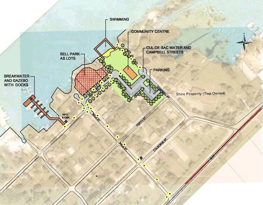
10 An additional observation is the poorly defined Community Centre parking lot at the corner of Water Street East and Campbell Street. The street corner radius is larger than other intersections allowing for faster driving speeds. The undefined edges of the parking lot and expanse of asphalt are out of keeping with the scale and character of the village. On-street parking of cars with boat trailers has become an issue, particularly to merchants who are concerned that this displaces customer parking. The existing docks are primarily rented seasonally with few spaces available for short-term and overnight visits. Portland s location, off to the side of the main route, between Rideau Canal locks reduces the demand for overnight docking and the low numbers do not warrant full-time staff to manage dock rentals

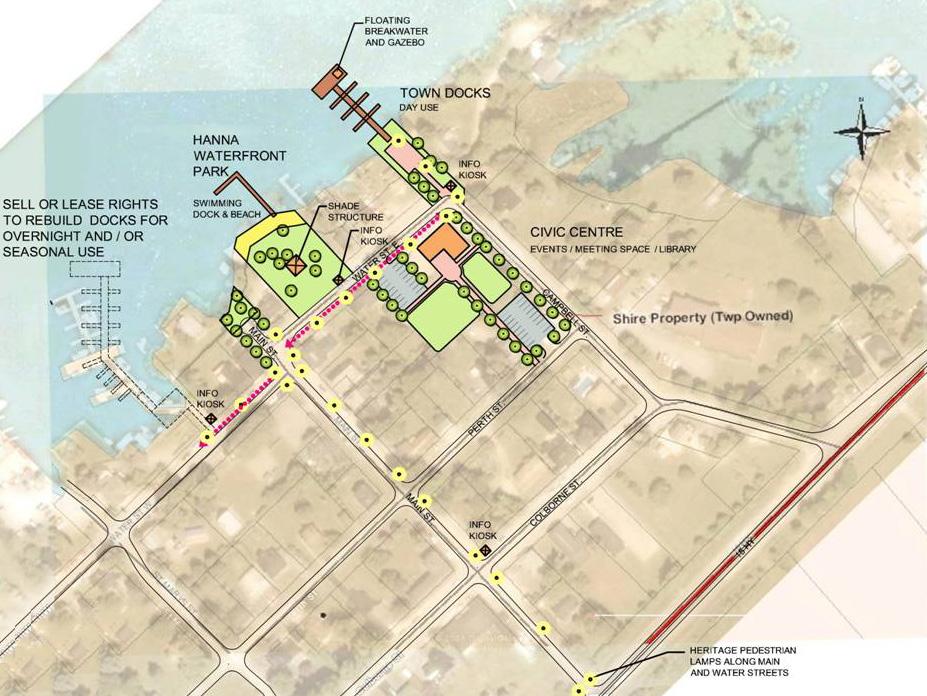
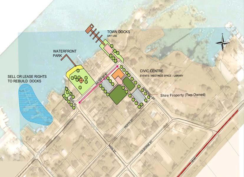
11 ALTERNATIVE CONCEPTS A series of alternative concepts were developed that would: Animate and articulate the waterfront; Convey the message that the municipal docks are public, from both the water and land; Improve the functional layout of the docks, including providing a breakwater and pier large enough for tour boats; Improve a swimming area and improve direct connections to the existing, or future, Community Centre for access to washrooms, day camp programs etc. and; Improve way-finding clues to link Highway 15 to the waterfront. The alternatives also explored potential acquisition or disposal of property to better consolidate the existing separated parcels of land owned by the Township, as well as facilitate phased implementation
12 - 12 -
13 - 13 -
14 - 14 -
15 - 15 -

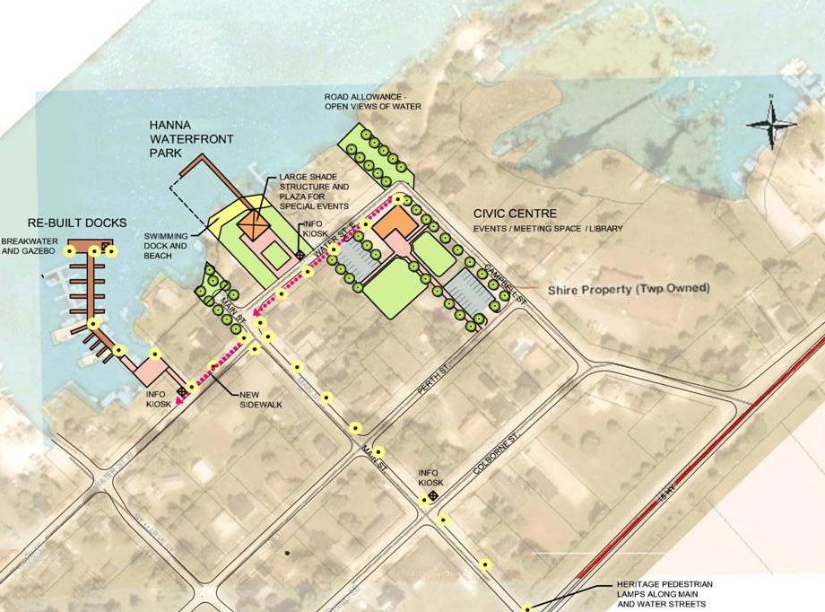
16 RECOMMENDED CONCEPT While several of the alternatives explored acquiring and disposing of Township owned property, the recommended concept utilizes only property currently owned by the Township. The component parts of the concept work together to provide clear identity of the waterfront as public facilities, as well as support a range of activities, as described below:

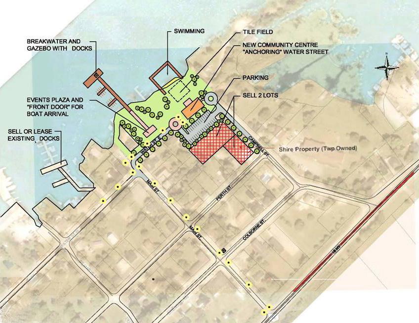
17 Existing Docks Given the narrow land connection and poor condition of the existing docks, the recommendation is to replace them at Hanna Park. While the existing docks are in poor condition, they remain a viable location for seasonal slip rentals that could be managed by the Township, sold, or leased to a private operator. RECOMMENDED CONCEPT Main Street and Water Street East and West The addition of sidewalks and heritage style pedestrian lamps on Main Street and both sides of Water Street would provide wayfinding clues to link Highway 15 with the waterfront. Lamps might be multiple headed, or raised on masonry bases to have more prominence at Highway 15, as well as the Water and Main Street intersection


18 Main Street Right-of-way Addition of a defined cul-de-sac turning bulb and street trees north of Water Street would clarify Main Street right-of-way as a public property. SIDEWALKS AND HERITAGE LAMPS ALONG MAIN STREET SIDEWALKS AND HERITAGE LAMPS AT WATER AND MAIN STREET INTERSECTION Hanna Park Hanna Park would be more inviting to visitors, and work better support for events with the addition of a small plaza, pedestrian lights, improved identity signage, shade trees, and a gazebo or shade structure. These elements would clearly identify this as a public park, as well as facilitate special events, with the close support of the community centre. The adjacent properties should be well buffered with fences and planting. This location is also well suited for new township Docks, as they would be very clearly visible from Water Street East, and the park would enhance the docks for waterborne arrival. The purpose of these docks would be primarily for short-term docking for visitors to the village potentially including tour boats. A large pier and breakwater at the farthest end of the docks would facilitate larger tour boats. This large dock should include a shade structure or gazebo as a destination for people to walk out on the docks, as well as to create a distinctive landmark for boaters approach from Big Rideau Lake


19 The character of the various dock elements should be an architectural family reflecting the heritage of Portland Village and convey a sense of quality to first time visitors. This family of similar elements should make reference to local architectural materials, colours, and forms. VOCABULARY OF PUBLIC ELEMENTS Cataraqui Trail CONCEPT 2: HANNA PARK AS HARBOUR AND EVENTS SPACE The Cataraqui Trail is located along an abandoned rail corridor that passes south of Portland Village. Signage leading to the trail by way of Harlem Road and Portland Station road would inform people interested in walking a loop or section of the trail. Signs at Harlem Road and Portland Station road would inform trail hikers that they are close to the village. USE SIGNAGE TO IDENTIFY WALKING LOOP TO CATARQUI TRAIL
20 Long-Term Potential While there is opportunity to optimize the functions of swimming, docks, a municipal event park, community centre, and parking on lands currently owned by the Township, the proposed arrangement is somewhat confined and disjointed. Should opportunity ever arise to acquire either or both the private lots between Hanna park and the Campbell Street right-of-way this would significantly consolidate and improve both function and presence of the public waterfront. LONG-TERM POTENTIAL TO EXPAND WATER- FRONT PARK AS ADDITIONAL LAND BECOMES AVAILABLE
3. COLTA / HUGA CONNECTIONS - PRELIMINARY
 9 3. COLTA / HUGA CONNECTIONS - PRELIMINARY 3.1 COLTA The Chain of Lakes Trail Association (COLTA) trail, formerly identified as the Chester Spur Line, was completed and opened for use in June 2011. The
places Mooloolaba s heart five
 five places the mooloolaba heart 1 Flexible community event use of school oval 2 Enhanced streetscape District cycle route Future cross-block pedestrian link 5 Existing school buildings New signalised
Washington Township MASTER PLAN. Addendum: Washington Township Master Plan
 Washington Township MASTER PLAN Addendum: Washington Township Master Plan CHAPTER XI RECREATION CORE DISTRICT Introduction The Recreation Core District generally encompasses the areas north of 30 Mile
Appendix F International Terminal Building Main Terminal Departures Level and Boarding Areas A and G Alternatives Analysis
 Appendix F International Terminal Building Main Terminal Departures Level and Boarding Areas A and G Alternatives Analysis ITB MAIN TERMINAL DEPARTURES LEVEL & BOARDING AREAS A & G ALTERNATIVES ANALYSIS
CRANE LAKE TRAILS NETWORK AND SPACES
 CRANE LAKE TRAILS NETWORK AND SPACES AREA TRAILS COMMUNITY TRAILS GOLD COAST TRAIL LAKE PARK OPTION ONE LAKE PARK OPTION TWO OVERFLOW TRAILHEAD PARKING THE GATE AREA TRAILS Trails are a major resource
Lake Waconia Regional Park 6. Lake Waconia Regional Park
 Lower Lakeshore Trail Interpretive/Adventure Trail Multiple Seating & Observation Areas Flexible Day Use Recreation Area Docks/Fishing Group Camping Group Day Use Space Winter Gathering/Event Space -Season
COCONUT GROVE WATERFRONT MASTER PLAN. ERA / Curtis Rogers / ConsulTech / Paul George Ph.D.
 COCONUT GROVE WATERFRONT MASTER PLAN ERA / Curtis Rogers / ConsulTech / Paul George Ph.D. Agenda City's Vision & Community Input Framework Concepts December 2006 Schemes Draft Final Plan Waterfront Open
AGENDA ITEM 5 D WAKULLA ENVIRONMENTAL INSTITUTE (WEI) TRAIL FEASIBILITY STUDY
 TRAIL FEASIBILITY STUDY") March 19, 2018 AGENDA ITEM 5 D WAKULLA ENVIRONMENTAL INSTITUTE (WEI) TRAIL FEASIBILITY STUDY TYPE OF ITEM: Action STATEMENT OF ISSUE The Wakulla Environmental Institute (WEI) Trail is one of several trails
March 19, 2018 AGENDA ITEM 5 D WAKULLA ENVIRONMENTAL INSTITUTE (WEI) TRAIL FEASIBILITY STUDY TYPE OF ITEM: Action STATEMENT OF ISSUE The Wakulla Environmental Institute (WEI) Trail is one of several trails
CORNWALL WATERFRONT PLAN 2007
 CANAL LANDS CANAL LANDS Page 58 Introduction This chapter details areas of possible development or redevelopment, and lands to be protected from any form of development in the Canal Lands area. As outlined
FUTURE PASSENGER PROCESSING. ACRP New Concepts for Airport Terminal Landside Facilities
 FUTURE PASSENGER PROCESSING ACRP 07-01 New Concepts for Airport Terminal Landside Facilities In association with: Ricondo & Associates, TransSolutions, TranSecure RESEARCH Background Research Objective
Alternative Highest & Best Use Analysis Boutique Hotel
 Alternative Highest & Best Use Analysis In response to numerous comments received from the public, as well as issues raised by the CCC in the Appeal Staff Report Substantial Issue Determination, the following
Chair and Members of Harbour East - Marine Drive Community Council. Brad Anguish, Director, Parks and Recreation
 P.O. Box 1749 Halifax, Nova Scotia B3J 3A5 Canada Item No. 15.1.1 Harbour East-Marine Drive Community Council December 3, 2015 TO: SUBMITTED BY: Chair and Members of Harbour East - Marine Drive Community
chapter - Hex Highway Touring Route Hamburg to Strausstown Overview
 chapter - 2 Hex Highway Touring Route Hamburg to Strausstown Overview The on-road Hex Highway automobile and bicycle touring route begins on State Street in downtown Hamburg. The route continues west on
MASTER PLAN July 24, 2014
 MASTER PLAN July 24, 2014 Vision Statement The newly expanded Rif Curaçao Seaport will enhance the island s ability to welcome guests to a vibrant and entertaining waterfront. The Rif Seaport Curaçao development
NFTA Access Enhancement Study for Canalside and Cobblestone Alternatives Discussion. Alternative A South Park Avenue
 Alternative A South Park Avenue Alternative A Summary Alternative A extends Metro Rail service around the foot of Main Street east along South Park Avenue to serve a new station platform located along
EP8.2 Presentation Exhibition GO Station Improvements
 EP8.2 Presentation Exhibition GO Station Improvements JANUARY 30, 2018 WORKING TOGETHER Metrolinx is working collaboratively with the City of Toronto, Exhibition Place, and the TTC to co-ordinate efforts
HARP AUTHORITY GATEWAY CENTER BOATHOUSE & CHANNEL EXTENSION TO SANTA FE AVENUE. Pueblo City Council Presentation September 17, 2018
 HARP AUTHORITY GATEWAY CENTER BOATHOUSE & CHANNEL EXTENSION TO SANTA FE AVENUE Pueblo City Council Presentation September 17, 2018 PROJECT: 1A HARP Expansion FUNDING 1A Ballot Issue Pueblo County : $3,000,000
The Vision for the San Juan Islands Scenic Byway
 The Vision for the San Juan Islands Scenic Byway 2 Judd Cove, Orcas Island, Courtesy of Kurt Thorson (kurtthorson.com) and San Juan County Land Bank Vision for the San Juan Islands Scenic Byway The San
Lake Wissota Access Locations within the LaFayette Township. By Chad Martin
 Lake Wissota Access Locations within the LaFayette Township By Chad Martin Anson/ Wissota Access Point # 1 Road: 195 th St. Associated Fire Numbers: 13294 Defining Characteristics: Forested from road
EDEN PARK REDEVELOPMENT COMPLETED STADIUM DESIGN
 1 INTRODUCTION New Zealand was awarded the Rugby World Cup 2011 hosting rights in November 2005. A condition of the winning bid was the provision of a 60,000 seat stadium for the finals. New Zealand s
A BOAT RAMP TO NOWHERE
 A BOAT RAMP TO NOWHERE A PROPOSAL FOR ACCESS TO HARVIE PASSAGE A Presentation to the City of Calgary December 2017 Presented by: Peter Crowe-Swords Bow River Trout Foundation Background: The Bow River
Staff Report. Re: National Park Service Ferry Landing Facilities at Piers 31, 31½ and 33 Joint Meeting with BCDC Design Review Board
 Port of San Francisco Waterfront Design Advisory Committee Agenda Item No. 1 Meeting Date: Staff Report To: From: Waterfront Design Advisory Committee: Laura Crescimano Jeff Joslin Marsha Maytum Kathrin
AIRPORT MASTER PLAN UPDATE
 AIRPORT MASTER PLAN UPDATE PENSACOLA INTERNATIONAL AIRPORT Technical Advisory Committee Meeting #2 June 20, 2017 Agenda» Introduction» Facility Requirements Airside Terminal Landside General Aviation Cargo
URBAN DESIGN REPORT. Proposed Residential Development, Old Church Road, Caledon East
 Proposed Residential Development, Old Church Road, Caledon East TABLE CONTENTS: 1.0 DEVELOPMENT 1.1 Introduction-Analysis of Guiding Principles and Documents 1.2 Community Design and Architectural Design
Birmingham Airport 2033
 Over the next 15 years, we will expand and improve the Airport to maximise our potential as a single runway airport by investing 500 million in new development. Our plans take account of our forecasted
Almaguin Strategic Plan - South River/Sundridge Airport
 June June 29, 29, 2009 2009 Page 1 Precision Management 26 Canterbury Crescent North Bay, Ontario P1C 1K7 Attention: Ms. Linda Wilson, B.B.A. (Hon.), M.B.A Re: Almaguin Strategic Plan - South River/Sundridge
A. CONCLUSIONS OF THE FGEIS
 Chapter 11: Traffic and Parking A. CONCLUSIONS OF THE FGEIS The FGEIS found that the Approved Plan will generate a substantial volume of vehicular and pedestrian activity, including an estimated 1,300
City of Haslett. City of East Lansing. City of East Lansing
 Central Park North (Nancy L. Moore Park) Lake Park North Expansion White Park Expansion #2 White Park Expansion #1 County East East Haslett East East TF87-212 Acquisition $90,000.00 Park. TF08-138 Acquisition
Lake Erie Commerce Center Traffic Analysis
 LOCATION: East of NYS Route 5 at Bayview Road Town of Hamburg Erie County, New York PREPARED BY: Wendel Companies 140 John James Audubon Parkway Suite 200 Amherst, New York 14228 January 2012 i ii Table
Sunshine Coast Airport Master Plan September 2007
 Sunshine Coast Airport Master Plan September 2007 Contents CONTENTS... I ACKNOWLEDGEMENT... II DISCLAIMER... III 1 EXECUTIVE SUMMARY...IV 1 INTRODUCTION... 1 2 AVIATION DEMAND FORECAST... 5 3 AIRCRAFT
Gardner: overview. Santa Fe, Oregon, and California National Historic Trails UNINCORPORATED JOHNSON COUNTY OLATHE UNINCORPORATED JOHNSON COUNTY
 Santa Fe, Oregon, and California ational Historic Trails : overview 99: p.134 100: p.135 GARDER JUCTIO 102: p.137 56: p.126 EDGERTO Burlington orthern Intermodal and Logistics 98: p.133 101: p.136 S Waverly
Addendum - Airport Development Alternatives (Chapter 6)
") Bowers Field Addendum - Airport Development Alternatives (Chapter 6) This addendum to the Airport Development Alternatives chapter includes the preferred airside development alternative and the preliminary
Bowers Field Addendum - Airport Development Alternatives (Chapter 6) This addendum to the Airport Development Alternatives chapter includes the preferred airside development alternative and the preliminary
CLEVELAND PARK LOCATION AND HISTORY EXISTING CONDITIONS AND CHARACTER LOCATION
 CLEVELAND PARK LOCATION LOCATION AND HISTORY Attempts to create a neighborhood park and playground in the Cleveland neighborhood began in 1926, when the park board designated for acquisition the block
user s guide to Transportation Improvements in Astoria Planning Efforts outside Astoria for more information, contact:
 The Miles Crossing/ Jeffers Garden transportation plan (underway), will identify needed improvements to the Warrenton Astoria Highway and local street improvements to serve expected growth in the Miles
RIVER ACCESS STRATEGY
 RIVER ACCESS STRATEGY The River Access Strategy is a 10-year plan the City of Edmonton is developing to inform future programming, operations and infrastructure improvements that support access to the
Calgary River Access Strategy Priority Sites and Proposed Funding
 Calgary River Access Strategy Priority Sites and Proposed Funding CPS2017-0103 ATTACHMENT 2 A total of $7,660,000 (Class 5 estimate) is required to implement all sites within the Calgary River Access Strategy;
1. Overview of Atlantic Highlands and Its Waterfront
 Atlantic Highlands 1. Overview of Atlantic Highlands and Its Waterfront Atlantic Highlands: Satellite Photo by USGS 1.1. Geographical Overview The Borough of Atlantic Highlands is on Sandy Hook Bay. It
Macleod Trail Corridor Study. Welcome. Macleod Trail Corridor Study Open House. Presentation of Proposed Design Concepts
 Macleod Trail Corridor Study Welcome Macleod Trail Corridor Study Open House Presentation of Proposed Design Concepts Study Purpose Develop a corridor plan for Macleod Trail that aligns with The City s:
Lake Tahoe Shoreline Plan 03 Policy Topic: Access Issues
 Lake Tahoe Shoreline Plan 03 Policy Topic: Access Issues V9 Last Updated 03.10.2017 1 Brief Description Physical access to the waters of Lake Tahoe is one of the key issues surrounding the Shoreline Plan
Chapter 8.0 Implementation Plan
 Chapter 8.0 Implementation Plan 8.1 Introduction This chapter is the culmination of the analytical work accomplished in the previous chapters. The result is a prioritized list of the essential projects.
MORGAN CREEK GREENWAY Final Report APPENDICES
 APPENDICES MORGAN CREEK GREENWAY Appendix A Photos of Existing Conditions in Trail Corridor Photos of existing conditions Main trail corridor - February 2009 Photos of existing conditions south bank Morgan
OPERATING DIRECTIVE Number: D Aviation Authority Revised: 03/25/15
 Page: 1 of 10 PURPOSE: To maintain the aesthetics of the airport by establishing standards and procedures to be followed by tenants concerning approval of and placement of tenant related displays, signs,
NORTHWEST SECTION CONTENTS: CLEVELAND PARK FOLWELL PARK RYAN LAKE PARK VICTORY PRAIRIE DOG PARK VICTORY PARK
 NORTHWEST SECTION CONTENTS: CLEVELAND PARK FOLWELL PARK RYAN LAKE PARK VICTORY PRAIRIE DOG PARK VICTORY PARK LUCY LANEY COMMUNITY SCHOOL N 33RD AVE N 33RD AVE SINGLE-FAMILY RESIDENTIAL MULTI-USE DIAMOND
WATER PETALUMA TRAIL WATER WAYS PROJECT PORTFOLIO. petalumawaterways.org OVERVIEW
 WATER TRAIL PROJECT PORTFOLIO OVERVIEW Thirteen miles upstream of San Pablo Bay, Petaluma is the northern point on the San Francisco Bay Water Trail, a network of access points throughout the region. Most
City of Durango 5.8 FUNDING TRAILS DEVELOPMENT
 5.8 FUNDING TRAILS DEVELOPMENT The City has been successful in establishing dedicated local funding sources as well as applying for grants to develop the City s trail system, having received nearly $2.4
The View at Bankhead Lake 12 miles off new Interstate Corridor X
 The View at Bankhead Lake 12 miles off new Interstate Corridor X offers the opportunity to the first to view 6 beautiful waterfront lots on Bankhead Lake to be released Saturday August 25th. Appointment
Blue River Trail Master Plan JSA to Town Hall June 2004
 Blue River Trail Master Plan JSA to Town Hall June 2004 Prepared for: Silverthorne Town Council Silverthorne SPORT Committee Department of Recreation and Culture Silverthorne Public Works Silverthorne
Traffic Management Plan 2018
 Traffic Management Plan 2018 Jesuit College Preparatory School of Dallas Amendment to Planned Development No. 353 Dallas, Texas June 6, 2018 Prepared for Jesuit College Preparatory School of Dallas Prepared
CITY RAIL LINK. New Public Transport Stations and Development Opportunities at Karangahape Road, Newton and Aotea Quarter
 134 AC_BEU_CCMP_3_TM5_8_FD.indd 134 20/07/12 12:30 PM 05 CITY RAIL LINK New Public Transport Stations and Development Opportunities at Karangahape Road, Newton and Aotea Quarter 5 MO VE 0 1 2 8 KEY 1 Britomart
FORECASTING FUTURE ACTIVITY
 EXECUTIVE SUMMARY The Eagle County Regional Airport (EGE) is known as a gateway into the heart of the Colorado Rocky Mountains, providing access to some of the nation s top ski resort towns (Vail, Beaver
TERMINAL DEVELOPMENT PLAN
 5.0 TERMINAL DEVELOPMENT PLAN 5.0 TERMINAL DEVELOPMENT PLAN Key points The development plan in the Master Plan includes the expansion of terminal infrastructure, creating integrated terminals for international,
Georgetown-Lewes Rail/Trail Study. Rail/Trail Study: Cool Spring to Cape Henlopen State Park New Road Extension (House Resolution No.
 Georgetown-Lewes Rail/Trail Study Rail/Trail Study: Cool Spring to Cape Henlopen State Park New Road Extension (House Resolution No. 47) August 22, 2011 Presentation Outline Background Benefits Statewide
RECREATIONAL VEHICLE EXAMPLES
 RV Ordinance 21.03.010 (I). Recreational Vehicles. 1. Purpose. The purpose of the recreational vehicle (RV) code is to clearly define what is considered a recreational vehicle and to identify locations
Northeast Quadrant Distinctive Features
 NORTHEAST QUADRANT Northeast Quadrant Distinctive Features LAND USE The Northeast Quadrant includes all the area within the planning area that is east of Interstate 5 and to the north of State Route 44.
CHAPTER 4 -- THE LAND USE PLAN: DESCRIPTIONS AND POLICIES FOR THIRTEEN PLANNING AREAS
 CHAPTER 4 -- THE LAND USE PLAN: DESCRIPTIONS AND POLICIES FOR THIRTEEN PLANNING AREAS NORTH CENTRAL CAC AREA LITTLE VALLEY ROAD TO JUG HANDLE CREEK PLANNING AREA This planning area includes Cleone, Noyo,
Longmont to Boulder Regional Trail Jay Road Connection DRAFT FINAL REPORT
 Longmont to Boulder Regional Trail Jay Road Connection DRAFT FINAL REPORT December 2018 Project Summary Boulder County, Colorado, in partnership with the City of Boulder, is evaluating options for multi-use
Pier Enhancements April 6, 2017
 Pier Enhancements April 6, 2017 Pier Enhancement Categories Pier Plaza Improvements Contingency Play Elements Destination Differentiators Water Recreation Zone Furniture, Fixtures & Equipment Transportation
Understanding the caring capacity of the visitor experience Provide facilities to support a high level user experience Address visual quality through
 Understanding the caring capacity of the visitor experience Provide facilities to support a high level user experience Address visual quality through recreation ecological restoration opportunities Collaboration
Survey Summary. 1. Overview. Pilot Implementation Survey Toronto Parks & Trails Wayfinding Strategy (Phase II) September 30 November 6, 2017
 September 30 November 6, 2017") Survey Summary Pilot Implementation Survey Toronto Parks & Trails Wayfinding Strategy (Phase II) September 30 November 6, 2017 1. Overview Between September 30 and November 6, 2017, the City of Toronto
Survey Summary Pilot Implementation Survey Toronto Parks & Trails Wayfinding Strategy (Phase II) September 30 November 6, 2017 1. Overview Between September 30 and November 6, 2017, the City of Toronto
CONTENTS. 1 Introduction Always Moving Forward while Building on the Past A Dynamic Destination... 5
 2010 STRUCTURE PLAN - 2 - CONTENTS 1 Introduction... 5 1.1 Always Moving Forward while Building on the Past... 5 1.2 A Dynamic Destination... 5 2 Map A... 6 Exhibition Place and its Neighbours... 7 3 Demonstration
F6. Coastal Ferry Terminal Zone
 F6. Coastal Ferry Terminal Zone F6.1. Zone description The purpose of the Coastal Ferry Terminal Zone is to provide for the integrated and efficient operation and development of ferry terminal facilities.
Bloor Street West Rezoning Application for a Temporary Use By-law Final Report
 STAFF REPORT ACTION REQUIRED 3741 3751 Bloor Street West Rezoning Application for a Temporary Use By-law Final Report Date: June 12, 2007 To: From: Wards: Reference Number: Etobicoke York Community Council
Proposal to Redevelop Lower Kananaskis River-Barrier Lake. Bow Valley Provincial Park
 Frequently Asked Questions Proposal to Redevelop Lower Kananaskis River-Barrier Lake Bow Valley Provincial Park Frequently Asked Questions What has been decided? What are the details of the plan? What
Waterfront Concept Plan: Community Survey Summary
 Waterfront Concept Plan: Community Survey Summary Published April 20, 2016 #1100085 Introduction The survey was one component of the public consultation process endorsed by Council in October, 2015. This
CHAPTER 4 -- THE LAND USE PLAN: DESCRIPTIONS AND POLICIES FOR THIRTEEN PLANNING AREAS
 CHAPTER 4 -- THE LAND USE PLAN: DESCRIPTIONS AND POLICIES FOR THIRTEEN PLANNING AREAS NORTH CENTRAL CAC PLANNING AREA 4.4 FORT BRAGG CITY LIMIT TO HARE CREEK PLANNING AREA (Includes Noyo) The Noyo community
Uniclass L534+L212. August home zones. paving PRECAST CONCRETE PAVING SOLUTIONS FOR TODAY S RESIDENTIAL STREET ENVIRONMENTS.
 August 2005 Uniclass L534+L212 paving home zones PRECAST CONCRETE PAVING SOLUTIONS FOR TODAY S RESIDENTIAL STREET ENVIRONMENTS www.paving.org.uk Home Zone Principles Home Zones are residential streets
Stakeholders Meeting
 Stakeholders Meeting for the Expansion of Runway 9R-27L, Terminal 4 Gate Relocation and Land Acquisition for Runway 9R-27L September 22, 2011 Stakeholders Meeting AGENDA Introduction FLL Airport Improvements
Non-Motorized Transportation
 Non-Motorized Transportation Non-motorized facilities are important components to the transportation system. They provide an environmentally-friendly, low-cost mode of travel. Some of the facilities can
BOAT DOCKS AND LAUNCHES. Public Engagement Report July 2015
 BOAT DOCKS AND LAUNCHES Public Engagement Report July 2015 TABLE OF CONTENTS BACKGROUND 3 STAKEHOLDER CONSULTATION 6 PARTICIPANT PROFILE 7 RESPONSE THEMES 8 CONCLUSION 16 BACKGROUND The North Saskatchewan
Canopy Creek Trail Extension and Entrance Node Design. Final Report Prepared for the Sackville Lakes Park and Trails Association
 Canopy Creek Trail Extension and Entrance Node Design 02.23.2017 Prepared for the Sackville Lakes Park and Trails Association Fenerty Lake Kinsac Lake Feely Lake Third Lake Discontinued Rail Corridor Second
Centurion Way Chichester
 Centurion Way Chichester Work book of plans to show details of the Centurion Way, its links, and potential developments and enhancements from linking to the South Downs National Park all the way to the
Hudson Highlands Fjord Trail Draft Master Plan. April 29, 2015
 Hudson Highlands Fjord Trail Draft Master Plan April 29, 2015 Agenda Route Overview Proposed Segment Results of Community Survey on that Segment Next Steps Municipal Endorsement Environmental Review Implementation
Waterfront and Marina Strategic Plan. May 26, 2015 Infrastructure, Investment & Development Committee
 Waterfront and Marina Strategic Plan May 26, 2015 Infrastructure, Investment & Development Committee 1 Purpose Background Update work completed or underway Vision & principles Balanced plan with opportunities
Acquisition in fee simple of approximately one-half acre of property on the shore of Spring Lake to expand the Lakeside Beach Park.
 Lakeside Beach TF00-136 $122,550.00 in fee simple of approximately one-half acre of property on the shore of Spring Lake to exp the Lakeside Beach. 2000 River Ravines TF00-150 $910,000.00 in fee simple
ONONDAGA CREEKWALK PHASE II. Public Information Meeting Series 1
 ONONDAGA CREEKWALK PHASE II Public Information Meeting Series 1 Andrew Maxwell Director, Syracuse-Onondaga County Planning Agency Owen Kerney Assistant Director for City Planning Russell Houck, PE City
Proposal to Redevelop Lower Kananaskis River-Barrier Lake. Bow Valley Provincial Park. Frequently Asked Questions
 Proposal to Redevelop Lower Kananaskis River-Barrier Lake Bow Valley Provincial Park Frequently Asked Questions What is being proposed? What are the details of the proposal? Where is the project area located?
MONTGOMERY COUNTY PLANNING DEPARTMENT THE MARYLAND-NATIONAL CAPITAL PARK AND PLANNING COMMISSION
 MONTGOMERY COUNTY PLANNING DEPARTMENT THE MARYLAND-NATIONAL CAPITAL PARK AND PLANNING COMMISSION Three Sisters Road: Abandonment No. AB740 MCPB Item No. 11 Date: 5-1-14 Katherine Holt, Senior Planner,
Classifications, Inventory and Level of Service
 Classifications, Inventory and Level of Service Section 3 Kenmore Park, Recreation and Open Space Plan 1 P a g e Classifications and Inventory Park Classifications Kenmore classifies its parks based upon
CHAPTER 4: ALTERNATIVES
 MSP Long Term Comprehensive Plan Update Metropolitan Airports Commission 4.1 INTRODUCTION CHAPTER 4: ALTERNATIVES Several alternatives were developed and evaluated based on their capability to meet the
Dufferin Jog Elimination Project
 Project Project Status Update November 14 2007 Project History Planning Alternatives Criteria Measured Project Benefits Structural Configurations Considered Structural Design Considerations The Preferred
Dogpatch Project Descriptions Summary DRAFT UNDER REVIEW January 11, 2017
 1. OPEN SPACE A. Esprit Park Why : Esprit Park, Dogpatch s only City Park, is already struggling under current use. It was not designed for intensive use and is not sustainable in its current state. What
Section Three, Part 14 Signs
 PART 14 SIGNS SIGNS 14.1 INTRODUCTION This part of the District Plan sets out the requirements in respect of signs. These matters were formerly controlled by bylaws. 14.2 OVERVIEW Signs form an integral
appendix E WATER FRONT KINGSTON Project Feasibility
 KINGSTON WATER FRONT Project Feasibility appendix E Kingston s Waterfront Master Plan Project Forecast The following tables organize the 138 projects into their viability as High, Moderate, Low and in
No 30 x 48 space is provided for a wheelchair under the picnic table.
 ITEM: LLOYD PARK PICNIC TABLE ADA GUIDELINE: 305, 902.2 No 30 x 48 space is provided for a wheelchair under the picnic table. Remove one of the picnic table arms. Photo of Picnic Table on the bluff PARK:
how it started where we are now what is coming up NEW WESTMINSTER WATERFRONT PARK THE RIVER THE PAST THE PEOPLE
 how it started Downtown Waterfront Park How It Started March 2009 City of New Westminster Purchases 3.2 Hectare Westminster Pier Site March 2009 City of New Westminster and Design Team develop plan for
FEASIBILITY CRITERIA
 This chapter describes the methodology and criteria used to evaluate the feasibility of developing trails throughout the study areas. Land availability, habitat sensitivity, roadway crossings and on-street
9.1 INTRODUCTION 9.2 EXISTING DEVELOPMENT. Southern Cross University
 Property Strategy The property strategy delivers improved legibility, responds to the locational attributes of the site, and facilitates essential operational efficiencies. 9.1 INTRODUCTION Non-aviation
Blueways: Rivers, lakes, or streams with public access for recreation that includes fishing, nature observation, and opportunities for boating.
 Parks, Open Space and Trails PRINCE WILLIAM COUNTY 2008 COMPREHENSIVE PLAN TRAILS PLAN CONTENTS The components of the trails plan are: Intent Definitions Goals, Policies, and Action Strategies Trails Map
POLICY & STRATEGIES The Vancouver Park Board approves major changes in Vancouver parks, including the design and development of parks.
 September 8, 2017 TO: Park Board Chair and Commissioners FROM: General Manager Vancouver Board of Parks and Recreation SUBJECT: Brewers Park and Clinton Park Renewal Concept Plans RECOMMENDATION THAT the
Flatford (including Bridge Cottage) Access Statement A small thatched cottage set in the countryside of the Dedham Vale.
 Access Statement A small thatched cottage set in the countryside of the Dedham Vale.") Flatford (including Bridge Cottage) Access Statement A small thatched cottage set in the countryside of the Dedham Vale. Contact details Bridge Cottage, Flatford, East Bergholt, Suffolk, CO7 6UL T: 01206
Flatford (including Bridge Cottage) Access Statement A small thatched cottage set in the countryside of the Dedham Vale. Contact details Bridge Cottage, Flatford, East Bergholt, Suffolk, CO7 6UL T: 01206
Is Scarborough City Centre A Transit Village?
 s Scarborough City Centre a Transit Vii? Martin Barakengera s Scarborough City Centre A Transit Village? Executive Summary The purpose of this Master's Report is to determine whether Scarborough City Centre
A. From I-68 in Monongalia County, West Virginia to SR 6119 in Fayette County, Pennsylvania 1
 Mon-Fayette Transportation Project A. From I-68 in Monongalia County, West Virginia to SR 6119 in Fayette County, Pennsylvania 1 The Mon/Fayette Transportation Project (MFTP) from I-68 in West Virginia
WELCOME WELCOME TO OUR PUBLIC EXHIBITION FOR THE BOND STREET PUBLIC REALM PROJECT.
 WELCOME WELCOME TO OUR PUBLIC EXHIBITION FOR THE BOND STREET PUBLIC REALM PROJECT. Bond Street Development Plan is one of the key initiatives outlined in the West End Partnership s vision. Bond Street
Hospital Link Project Project Update Winter 2018
 Hospital Link Project Project Update Winter 2018 General The project provides a link from Riverside Drive and the Transitway to the Hospital Link Road. Construction of the Hospital Link facility is open
Danvers River Committee Thursday April 20, 2017 Meeting Minutes
 Danvers River Committee Thursday April 20, 2017 Meeting Minutes The Danvers River Committee held a public meeting on Thursday April 20, 2017 in the Town Manager s Conference Room, Danvers Town Hall, at
HARBOUR EDGE STITCH. Uniting the Waterfront with the City Centre
 78 AC_BEU_CCMP_2_TM1_4 _FD.indd 78 20/07/12 12:04 PM 01 HARBOUR EDGE STITCH Uniting the Waterfront with the City Centre 01 VISION OUR 2032 VISION IS: Quay Street as a high-quality Harbour Edge space that
AMBIENCE IMPROVEMENT PROJECT O.R TAMBO INTERNATIONAL AIRPORT CONCEPT DESIGN
 AMBIENCE IMPROVEMENT PROJECT O.R TAMBO INTERNATIONAL AIRPORT CONCEPT DESIGN DATE: 01 MARCH 2017 Page 2 Good ambience can make the whole experience seem better Page 3 The challenge posed by a project of
University Region Non-Motorized Plan 2015
 Non-Motorized Transportation Non-motorized facilities are important components to the transportation system. They provide an environmentally-friendly, low-cost mode of travel. Some of the facilities can
Grade Crossings in High Speed Rail Corridors
 Grade Crossings in High Speed Rail Corridors 59 th ANNUAL ILLINOIS TRAFFIC ENGINEERING & SAFETY CONFERENCE October 21, 2010 Champaign, IL Michael E. Stead Rail Safety Section Illinois Commerce Commission
REVISED AGENDA. Special Council Meeting. Monday, September 11, 2017 (REVISED TO INCLUDE ON-TABLE ITEMS)
") Mission Statement In carrying out its mandate, Bowen Island Municipality will work towards conducting operations in a way that: Improves the economic, environmental and social well-being for present and
Mission Statement In carrying out its mandate, Bowen Island Municipality will work towards conducting operations in a way that: Improves the economic, environmental and social well-being for present and