1.4 Understand how moving ice acts as an agent of erosion and deposition. (Chap. 2)
|
|
|
- Lesley Lewis
- 5 years ago
- Views:
Transcription
1 1.4 Understand how moving ice acts as an agent of erosion and deposition. (Chap. 2) There are two types of glaciation. Alpine Glaciation Continental Glaciation
2 Distinguish between the terms alpine glaciation and continental glaciation. (P.32)
3 Alpine Glaciation Alpine glaciers form high in mountain valleys; above the snow-line
4 C D E B A Alpine Glaciation
5
6

7 Continental Glaciation Continental glaciers cover parts of continental land masses; ex Greenland
8
9
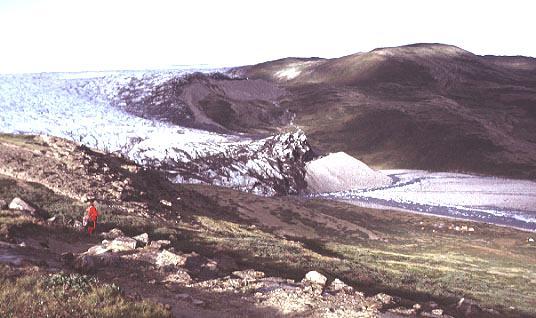
10 Distinguish between the terms alpine glaciation and continental glaciation. (P.32) Similarities Both move and cause erosion Both change the landscape Both developed in constantly cold < 0 0 C Differences Location Alpine = mountain Continental = earth poles Size Alpine = smaller Continental = larger
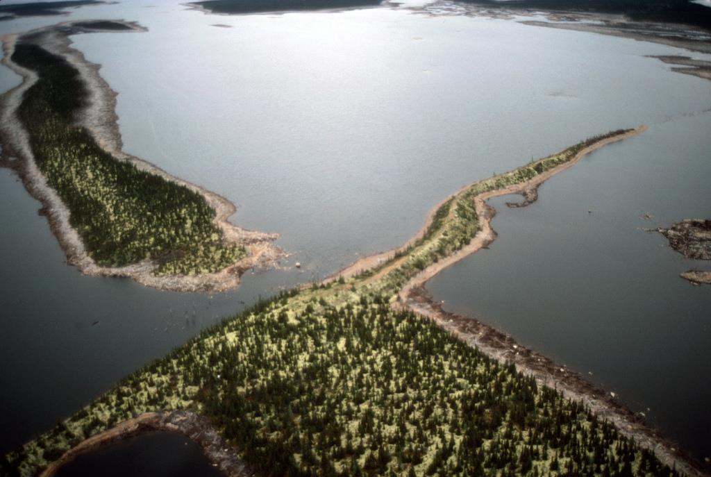
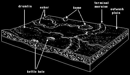
11 Define the terms outwash plain, terminal moraine, erratics, drumlins & eskers. (P. 33 Q.12) These features are associated with continental glaciation. See picture p. 34
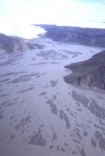
12 Outwash plain Similar to a river delta Melt water flowing from the glacier deposits silt Deposited in layers Small particles carried further away Larger particles drop closer to the glacier Outwash plain

13 Outwash Plain
14 Continental Outwash plain Outwash Plain

15 Continental Outwash plain

16 Continental Outwash plain
17 Terminal moraine Heap or ridge of bulldozed gravel that marks the end of the forward motion of a glacier As glacier retreats it deposits debris/gravel P. 34
18 Continental Terminal Moraine Terminal Moraine Outwash Plain

19 Continental Terminal Moraine

20 Erratics Large boulders that were transported long distances and dropped They now sit in a region and look very much out-of-place. P. 34
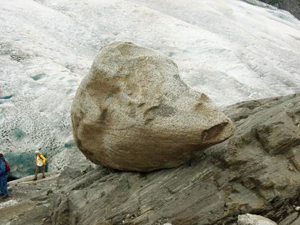
21 Erratic
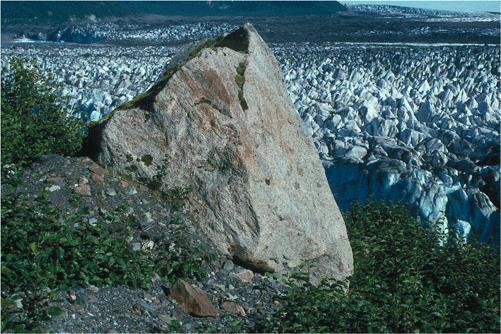
22 Erratic
23 Continental Erratic Terminal Moraine Outwash Plain Erratic
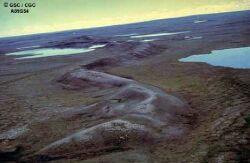
24 Drumlins p. 34 Egg shaped hill Formed under glaciers Sloped or Pointy end points in direction of ice flow
25 Drumlins p. 34 Formation Ice melts under glacier Deposits of gravel made Glacier moves forward Deposits are bull-dozed along and catches up in rough areas forming piles or drumlins.

26 Drumlin What direction did the glacier move?
27 Continental Drumlin Terminal Moraine Drumlins Outwash Plain Erratic
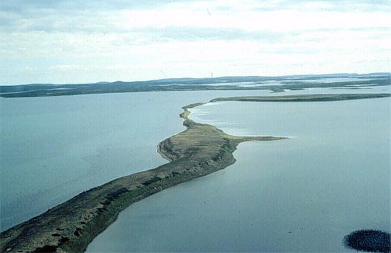
28 Esker p. 34 Long deposits of eroded glacial material Formed by sub-glacial streams that deposit material like all rivers. Highways of the North!!
29 Esker
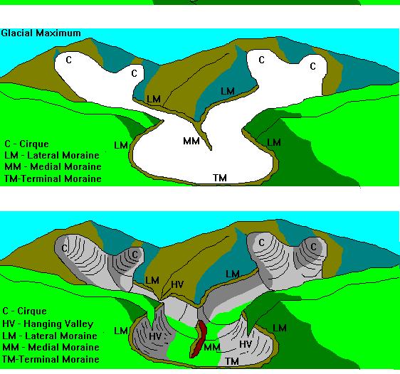
30 Esker
31
32
33 Continental Esker Terminal Moraine Drumlins Esker Outwash Plain Erratic
34 Examine evidence for the direction of movement of glaciers. (P. 34 question # 13) 1. Sloped end of drumlin 2. Location of terminal moraine What is direction of glacier movement in this picture?

35 Continental Outwash Plain
36 Continental Esker Terminal Moraine Drumlins Esker Outwash Plain Erratic
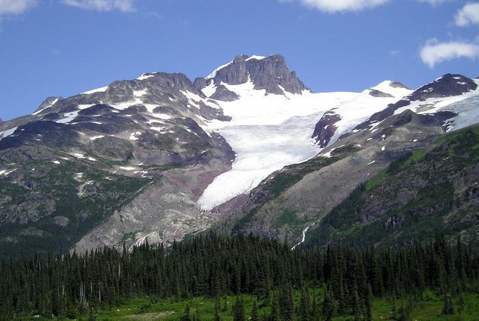
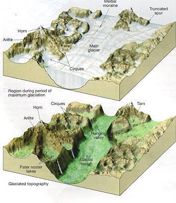
37 Define the terms cirque, arête, hanging valley, lateral moraine, and terminal moraine. (P. 36) These features are associated with alpine glaciers

38 Alpine glaciers Alpine glaciers are like very slow moving rivers of ice flowing down high mountain valleys.
39 Cirque (p. 36) a circular hollow cut into bedrock during glaciation Side and back walls are steep but front wall opens downward
40 Cirque - How formed? Alpine glacier freezes onto mountain valley and as is proceeds it plucks rock from the mountain top leaving the cirque shape.
41 C D E Cirque B A
42 Cirque
43 Arête p. 36 Steep, jagged, narrow, knife edged ridge between two cirques or glacier valleys.
44 Arete C D E Cirque B A
45 Arête
46 Truncated Spur Blunt-ended ridge of rock jutting from the side of a glacial trough, or valley Seen where hillsides are bisected by glacier Song?
47 Truncated spurs Arete C D E Cirque B A
48 Horn or Pyramidal Peak is a mountain top (peak) that has been modified by the action of ice during glaciation.
49 Truncated spurs Arete C Horn D E Cirque B A
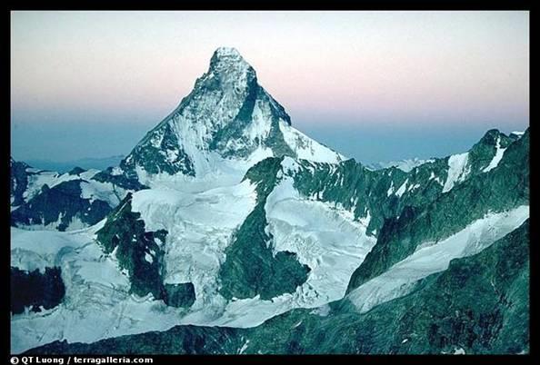
50 Horn
51 Hanging Valley Most noticeable once glacier has melted! A high level tributary valley from which the ground falls sharply to the level of the lower, main valley. The depth of the lower valley is due to more severe glaciation.

52 Hanging Valley

53 Hanging Valley

54 Hanging Valley in Newfoundland Hanging Valley in Gros Morne National park. Trout River pond
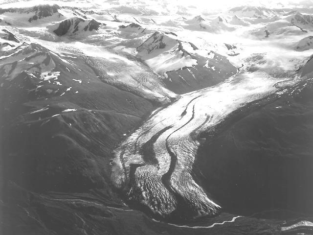
55 Lateral Moraine Moraine means 'rock waste'. It is also known as glacial till Lateral Moraine is the land-form deposited at the side of a glacier Debris/waste rock drops off the side of the mountain as the glacier moves forming a ridge of debris at the outer-sides of the glacier.
56 Lateral Moraine Lateral Moraines
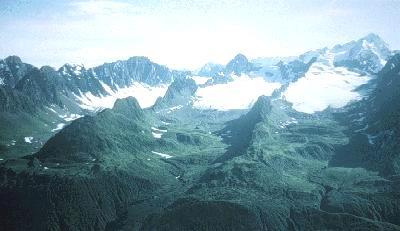
57 Kaskawulsh Glacier St. Elias Mtns - Arctic
58 Terminal Moraine deposits that mark the farthest extent of the glacier Good indicator of the direction or movement of the glacier as well.
59 Alpine Glaciation Terminal Moraine
60 Medial Moraine This is a ridge of rock waste found along the middle of the floor of a u - shaped valley. It occurs when two glaciers meet, two lateral moraines unite to form a medial moraine.
61 Medial Moraine Medial Moraine
62 Medial Moraine Medial Moraine
63 Alpine Glaciation

64 Kaskawulsh Glacier St. Elias Mtns - Arctic
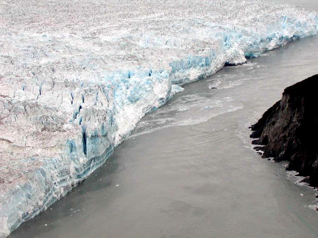
65 Describe how fiords are formed. (P.37) 1. Alpine Glaciers erode troughs & valleys in the mountain 2. Glacier valley reaches the coast. 3. Glacier melts and sea water floods the valley
66 Fiord A glacially eroded or modified U-shaped valley that extends below sea level and connects to the ocean. Filled with seawater

67 Gross Morne - Fiord

68 Fiord in Norway Norway is well known for its abundant fiords
69
70
71
72
73
74
75
1 Glacial Erosion and
 www.ck12.org Chapter 1. Glacial Erosion and Deposition CHAPTER 1 Glacial Erosion and Deposition Lesson Objectives Discuss the different erosional features formed by alpine glaciers. Describe the processes
Recrystallization of snow to form LARGE. called FIRN: like packed snowballs. the weight of overlying firn and snow.
 Chapter 11 Glaciers BFRB P. 103-104, 104, 108, 117-120120 Process of Glacier Formation Snow does NOT melt in summer Recrystallization of snow to form LARGE crystals of ice (rough and granular) called
glacier Little Ice Age continental glacier valley glacier ice cap glaciation firn glacial ice plastic flow basal slip Chapter 14
 Little Ice Age glacier valley glacier continental glacier ice cap glaciation firn glacial ice plastic flow basal slip glacial budget zone of accumulation zone of wastage glacial surge abrasion glacial
PHYSICAL GEOGRAPHY GEOGRAPHY EARTH SYSTEMS COASTAL SYSTEMS FLUVIAL SYSTEMS
 PHYSICAL GEOGRAPHY EARTH SYSTEMS FLUVIAL SYSTEMS COASTAL SYSTEMS PHYSICAL GEOGRAPHY CORRIES / CIRQUES A Corrie or Cirque is the armchair shaped hollow that was the birthplace of a glacier. It has steep,
Q: What is a period of time whereby the average global temperature has decreased? Q: What is a glacier?
 Q: What is a glacier? A: A large sheet of ice which lasts all year round. Q: What is a period of time whereby the average global temperature has decreased? A: A glacial. Q: What is an interglacial? Q:
Glaciers and Glaciation Earth - Chapter 18 Stan Hatfield Southwestern Illinois College
 Glaciers and Glaciation Earth - Chapter 18 Stan Hatfield Southwestern Illinois College Glaciers Glaciers are parts of two basic cycles: 1. Hydrologic cycle 2. Rock cycle A glacier is a thick mass of ice
Making glacial connections
 Student task A 1. Cut and arrange the cards below to make four sets of four connections: Four connections Matterhorn drumlin lateral U-shaped valley outwash plain truncated spur Lauterbrunnen ground medial
Red Tarn, Lake District They are all features of glacial erosion
 Ribbon Lake Lake Windermere, Lake District Arete Striding Edge, Lake District 1 2 3 Pyramidal Peak Corrie & Tarn 4 Matterhorn, Switzerland Red Tarn, Lake District They are all features of glacial erosion
Glaciers Earth 9th Edition Chapter 18 Mass wasting: summary in haiku form Glaciers Glaciers Glaciers Glaciers Formation of glacial ice
 1 2 3 4 5 6 7 8 9 10 11 12 13 14 15 Earth 9 th Edition Chapter 18 Mass wasting: summary in haiku form Ten thousand years thence big glaciers began to melt - called "global warming." are parts of two basic
I. Types of Glaciers 11/22/2011. I. Types of Glaciers. Glaciers and Glaciation. Chapter 11 Temp. B. Types of glaciers
 Why should I care about glaciers? Look closely at this graph to understand why we should care? and Glaciation Chapter 11 Temp I. Types of A. Glacier a thick mass of ice that originates on land from the
Chapter 16 Glaciers and Glaciations
 Chapter 16 Glaciers and Glaciations Name: Page 419-454 (2nd Ed.) ; Page 406-439 (1st Ed.) Part A: Anticipation Guide: Please read through these statements before reading and mark them as true or false.
The Physical Geography of Long Island
 The Physical Geography of Long Island A Bit About Long Island Length 118 miles Brooklyn to Montauk Geo202 Spring 2012 Width 23 miles at it s widest Area 1,400 square miles Formation of Long Island River
LAB P - GLACIAL PROCESSES AND LANDSCAPES
 Introduction LAB P - GLACIAL PROCESSES AND LANDSCAPES Ice has been a significant force in modifying the surface of the earth at numerous times throughout Earth s history. Though more important during the
Glaciers. Glacier Dynamics. Glacier Dynamics. Glaciers and Glaciation. Types of Glaciers. Chapter 15
 Chapter 15 Glaciers and Glaciation Glaciers A glacier is a large, permanent (nonseasonal) mass of ice that is formed on land and moves under the force of gravity. Glaciers may form anywhere that snow accumulation
Chapter 14. Glaciers and Glaciation
 Chapter 14 Glaciers and Glaciation Introduction Pleistocene Glaciations: A series of "ice ages" and warmer intervals that occurred 2.6 million to 10,000 years ago. The Little Ice Age was a time of colder
Glaciers. Chapter 17
 Glaciers Chapter 17 Vocabulary 1. Glacier 2. Snowfield 3. Firn 4. Alpine glacier 5. Continental glacier 6. Basal slip 7. Internal plastic flow 8. Crevasses 9. Glacial grooves 10. Ice shelves 11. Icebergs
Shaping of North America. Physical Geography II of the United States and Canada. The Last Ice Age. The Ice Age. Pleistocene Polar Ice Cap 2/14/2013
 Physical Geography II of the United States and Canada Prof. Anthony Grande AFG 2012 Shaping of North America The chief shaper of the landscape of North America is and has been running water. Glaciation
Glaciers and Glaciation
 Chapter 18 Lecture Earth: An Introduction to Physical Geology Eleventh Edition Glaciers and Glaciation Tarbuck and Lutgens Glaciers: A Part of Two Basic Cycles A glacier is a thick mass of ice that forms,
Glaciers. Valley or Alpine glaciers. Ice sheets. Piedmont - foot of the mountain glaciers. Form in mountainous areas Move downslope in valleys
 Glaciers & Ice Ages Glaciers Valley or Alpine glaciers Form in mountainous areas Move downslope in valleys Ice sheets Move outward from center Continental glaciers - large scale, ice age type. Presently
2. (1pt) From an aircraft, how can you tell the difference between a snowfield and a snow-covered glacier?
 From an aircraft, how can you tell the difference between a snowfield and a snow-covered glacier?") 1 GLACIERS 1. (2pts) Define a glacier: 2. (1pt) From an aircraft, how can you tell the difference between a snowfield and a snow-covered glacier? 3. (2pts) What is the relative size of Antarctica, Greenland,
1 GLACIERS 1. (2pts) Define a glacier: 2. (1pt) From an aircraft, how can you tell the difference between a snowfield and a snow-covered glacier? 3. (2pts) What is the relative size of Antarctica, Greenland,
Landscapes in the UK: Glaciation 1. Extent of ice cover across the UK during the last ice age.
 Landscapes in the UK: Glaciation 1. Extent of ice cover across the UK during the last ice age. Key idea: Ice was a powerful force in shaping the landscape of the UK. In the past the climate has got colder
Glaciers. Glacier Dynamics. Glaciers and Glaciation. East Greenland. Types of Glaciers. Chapter 16
 Chapter 16 Glaciers A glacier is a large, permanent (nonseasonal) mass of ice that is formed on land and moves under the force of gravity. Glaciers may form anywhere that snow accumulation exceeds seasonal
READING QUESTIONS: Chapter 7, Glaciers GEOL 131 Fall pts. a. Alpine Ice from larger ice masses flowing through a valley to the ocean
 READING QUESTIONS: Chapter 7, Glaciers GEOL 131 Fall 2018 63 pts NAME DUE: Tuesday, October 23 Glaciers: A Part of Two Basic Cycles (p. 192-195) 1. Match each type of glacier to its description: (2 pts)
READING QUESTIONS: Glaciers GEOL /WI 60 pts. a. Alpine Ice from larger ice masses flowing through a valley to the ocean
 READING QUESTIONS: Glaciers GEOL 131 18/WI 60 pts NAME DUE: Tuesday, March 13 Glaciers: A Part of Two Basic Cycles (p. 192-195) 1. Match each type of glacier to its description: (2 pts) a. Alpine Ice from
Glaciers. Clicker Question. Glaciers and Glaciation. How familiar are you with glaciers? West Greenland. Types of Glaciers.
 Chapter 21 Glaciers A glacier is a large, permanent (nonseasonal) mass of ice that is formed on land and moves under the force of gravity. Glaciers may form anywhere that snow accumulation exceeds seasonal
Formation of a Corrie
 Formation of a Corrie A corrie looks rather like a armchair has been cut out of the rock face When a hill has been heavily eroded with 3 or 4 corries the jagged hill that is left is known as a pyramidal
Landscapes in the UK: Glaciation 1. Extent of ice cover across the UK during the last ice age.
 Landscapes in the UK: Glaciation 1. Extent of ice cover across the UK during the last ice age. Key idea: Ice was a powerful force in shaping the landscape of the UK. As the climate has changed in the past,
ENVI2030L - ALPINE AND CONTINENTAL GLACIATION
 NAME ENVI2030L - ALPINE AND CONTINENTAL GLACIATION I. Introduction Glaciers are slowly moving ice sheets. They are very effective erosional agents and can drastically modify the landscapes over which they
GLACIATION. The Last Ice Age (see Chapter 12) and. Pleistocene Ice Cap. Glacial Dynamics 10/2/2012. Laurentide Ice Sheet over NYS
 and. Pleistocene Ice Cap. Glacial Dynamics 10/2/2012. Laurentide Ice Sheet over NYS") GLACIATION and New York State Prof. Anthony Grande The Last Ice Age (see Chapter 1) The Pleistocene Epoch began 1.6 mya. During this time, climates grew colder. There were numerous ice ages starting 100,000000
GLACIATION and New York State Prof. Anthony Grande The Last Ice Age (see Chapter 1) The Pleistocene Epoch began 1.6 mya. During this time, climates grew colder. There were numerous ice ages starting 100,000000
Unit 1: Physical Environment Glaciated Landscapes
 Unit 1: Physical Environment Glaciated Landscapes Corries Corries are bowl-shaped hollows high up in the mountains. They are formed in the following way: Snow collects in a hollow on a mountainside (usually
glacial drift: all deposits associated with glaciation; covers 8% of Earth s surface above sealevel, and 25% of North America
 Glacial depositional features glacial drift: all deposits associated with glaciation; covers 8% of Earth s surface above sealevel, and 25% of North America i) nonstratified drift till: transported & deposited
Mearns Castle High School. Geography Department. Glaciated Landscapes
 Mearns Castle High School Geography Department Glaciated Landscapes Lesson One: Location of Glaciated Uplands in the British Isles The Ice Age in Britain began about 1,000,000 years ago and lasted until
Glaciers Earth Chapter 18 Chapter 18 Glaciers & Glaciation Glaciers: A Part of Two Basic Cycles Glaciers: A Part of Two Basic Cycles Valley Glacier
 1 2 3 4 5 6 7 8 9 10 11 12 Glaciers Earth Chapter 18 Chapter 18 Glaciers & Glaciation A glacier is a thick mass of ice that forms, over hundreds and thousands of years, by the accumulation, compaction,
Great Science Adventures
 Great Science Adventures Lesson 18 How do glaciers affect the land? Lithosphere Concepts: There are two kinds of glaciers: valley glaciers which form in high mountain valleys, and continental glaciers
Dynamic Planet: Glaciers
 Team Name+Number Teammate 1 name Teammate 2 name Dynamic Planet: Glaciers (by Shad160) The following test is 80 questions long, split up into four different sections. The first 20 questions are worth 40
Alpine Glacial Features along the Chimney Pond Trail, Baxter State Park, Maine
 Maine Geologic Facts and Localities September, 2009 Alpine Glacial Features along the Chimney Pond Trail, Baxter State Park, Maine 45 54 57.98 N, 68 54 41.48 W Text by Robert A. Johnston, Department of
Glaciers. Reading Practice
 Reading Practice A Glaciers Besides the earth s oceans, glacier ice is the largest source of water on earth. A glacier is a massive stream or sheet of ice that moves underneath itself under the influence
Chapter 17. Glacial & Periglacial Landscapes
 Chapter 17 Glacial & Periglacial Landscapes Cryosphere Cryosphere - the portions of Earth's surface where water is in solid form, including sea ice, lake ice, river ice, snow cover, glaciers, ice caps,
How Glaciers Change the World By ReadWorks
 How Glaciers Change the World How Glaciers Change the World By ReadWorks Glaciers are large masses of ice that can be found in either the oceans or on land. These large bodies of frozen water have big
Teacher s Guide For. Glaciers
 Teacher s Guide For Glaciers For grade 7 - College Program produced by Centre Communications, Inc. for Ambrose Video Publishing, Inc. Executive Producer William V. Ambrose Teacher's Guide by Mark Reeder
Geologic Trips, Sierra Nevada
 ISBN 0-9661316-5-7 GeoPress Excerpt from Geologic Trips, Sierra Nevada by Ted Konigsmark All rights reserved. No part of this book may be reproduced without written permission, except for critical articles
Gifts of the Glaciers
 Gifts of the Glaciers Gifts of the Glaciers Moving ice of glacier was responsible for water, landforms, and soil characteristics and patterns of today Sculpturing of bedrock materials Glacial Landforms
Glaciers and Periglaciers
 Glaciers and Periglaciers Chapter 9, page 132 Glaciation!1836 Louis Agassiz theorized that parts of Europe and North America were covered by huge ice sheets.!known as the Pleistocene Ice Ages Why do we
Parts of a Glacier Division A Study Guide- Part 2
 Parts of a Glacier Division A Study Guide- Part 2 Zones of a glacier Zone of Accumulation: The region where snowfall adds ice to the glacier. It occurs where the temperature remains cold enough year-round
How this guide works...
 How this guide works... This guide is the ice on the land revision guide and should be used alongside the exam question booklet you got last term. Together it gives you a full and detailed guide of everything
Please make sure that all teachers and chaperones attending the field study are aware of the following information:
 Dear Teacher, Thank you for signing up for The Ice Age at the Lost Valley Visitor Center in Glacial Park. The visitor center is located in the middle of Glacial Park. Follow the signs from the Harts Road
Glacial Geomorphology Exercise
 James Madison University Field Course in western Ireland Glacial Geomorphology Exercise 3-day road log (abbreviated) Striations Large kame terrace Cirque with moraines Kame delta Striations Eskers Raised
MIDDLE SCHOOL CURRICULUM TR AILING ICE AGE M YST ERI E S ICE AGE TREKKING
 MIDDLE SCHOOL CURRICULUM TR AILING ICE AGE M YST ERI E S ICE AGE TREKKING CONTENTS I. Enduring Knowledge... 3 II. Teacher Background... 3 III. Before Viewing this Video... 5 IV. Viewing Guide... 5 V. Discussion
c. 1 inch = 0.6 miles e. 1:100,000 f. 1:250,000 f. 1 inch = 4.0 miles
 High School Advance Geology Map Test 2014 Name Use the information on each map to provide the best answer to the questions. Fill in the bubble of the best answer on your answer sheet. Answer questions
Dynamic Planet C Test
 Northern Regional: January 19 th, 2019 Dynamic Planet C Test Name(s): Team Name: School Name: Team Number: Rank: Score: Dynamic Planet B/C Glaciers (87 total points) Multiple choice/fill in the blank (23
NYS Invitational Science Olympiad April 2005 DYNAMIC PLANET: GLACIERS
 NYS Invitational Science Olympiad April 2005 School Team # DYNAMIC PLANET: GLACIERS 1. What type of glacier is shown in the photo? 2. a. What is the name of the feature labeled A? b. How did feature A
Name Team Number. 1. The famous question: What percent of Earth's surface is covered by glaciers? A) 5% D) neve
 5% D) neve") Part I: Multiple Choice (30pts) Directions: Please choose the best answer for each question. There is only one correct answer for each question unless otherwise stated. There are 30 questions. Each one
Part I: Multiple Choice (30pts) Directions: Please choose the best answer for each question. There is only one correct answer for each question unless otherwise stated. There are 30 questions. Each one
E arth s climate strongly influences
 Section 7.1 7.1 Glaciers 1 FOCUS Section Objectives 7.1 Describe the different types of glaciers and where each type is found. 7.2 Explain how glaciers move and describe the different types of glacial
GEOMORPHOLOGY EXAM #3
 Formation of Glaciers GEOMORPHOLOGY EXAM #3 - Transformation of snow into glacial ice - Density; SNOW = 0.07 0.18 g/cc FIRN(Neve) = 0.4 0.8 g/cc (Pellets) GLACIAL ICE = 0.8 0.9 g/cc - Firn / Ice Boundary
Glacial Origins and Features of Long Island
 Glacial Origins and Features of Long Island Interior Coastal Plain Continental Shelf Long Island s Geology 0 Ma Phanerozoic 540 Ma Proterozoic 2500 Ma Archean 3800 Ma Hadean 4600 Ma C M P Geologic Time
The Northeast: America's Gateway to the World
 The Northeast: America's Gateway to the World Living in the Shadow of the Ice a lesson on the impact of glaciation on Northeast landscapes INTRODUCTION: The region we call the Northeast has a very long
GC 225 Lecture Exam #2
 GC 225 Lecture Exam #2 Direction- path along which something is moving. 3 Types; - COMPASS DIRECTIONAL NAME (32 in total) - BEARING (four 0 o - 90 o ) - AZIMUTHS (0 o - 360 o ) Compass (32 named points)
The Potentially Dangerous Glacial Lakes
 Chapter 11 The Potentially Dangerous Glacial Lakes On the basis of actively retreating glaciers and other criteria, the potentially dangerous glacial lakes were identified using the spatial and attribute
MIDDLE SCHOOL CURRICULUM TR AILING ICE AGE M YST ERI E S SEARCHING GLACIAL FEATURES
 MIDDLE SCHOOL CURRICULUM TR AILING ICE AGE M YST ERI E S SEARCHING GLACIAL FEATURES CONTENTS I. Enduring Knowledge... 3 II. Teacher Background... 3 III. Before Viewing the Video... 5 IV. Viewing Guide...
Dynamic Planet Practice Test Written by Samuel Bressler
 Dynamic Planet Practice Test 2013 Written by Samuel Bressler Part 1: Multiple Choice 1. Which of the following is NOT related to alpine glaciation? a) Serac b) Kame c) Col d) Paternoster Lake 2. The common
Mighty Glaciers. Mighty Glaciers. Visit for thousands of books and materials.
 Mighty Glaciers A Reading A Z Level M Leveled Reader Word Count: 684 LEVELED READER M Mighty Glaciers Written by Ned Jensen Visit www.readinga-z.com for thousands of books and materials. www.readinga-z.com
Lesson. Glaciers Carve the Land A QUICK LOOK. Overview. Big Idea. Process Skills Key Notes
 EARTH S CHANGING SURFACE CLUSTER 2 HOW THE EARTH S SURFACE CHANGES Lesson 62 Glaciers Carve the Land A QUICK LOOK Big Idea Moving water, ice, and wind break down rock, transport materials, and build up
Did It. naturalists. Young. Moving and melting ice shaped many of Minnesota s land features. 30 Minnesota Conservation Volunteer
 Young naturalists by Mary Hoff Photography by Gary Alan Nelson T he Glacier Did It Moving and melting ice shaped many of Minnesota s land features. Shut your eyes. Imagine that it s a sunny summer day
A trip to Steindalen. - geology and landscape on the way to the glacier. Geoffrey D. Corner
 A TRIP TO STEINDALEN Excursion guide Please take this with you on your trip, but don t leave it behind as litter. A trip to Steindalen - geology and landscape on the way to the glacier A part of Geologiskolen,
Lesson 5: Ice in Action
 Everest Education Expedition Curriculum Lesson 5: Ice in Action Created by Montana State University Extended University and Montana NSF EPSCoR http://www.montana.edu/everest Lesson Overview: Explore glaciers
Just to the left of the trail head sign and across the dirt road, please notice a granite post. Well
 Rice Natural Area TWO BROOKS TRAIL TRAILS WITH TALES, #1 Introduction The land you are about to enter is a quiet place. It is also quite extraordinary. Enjoy your visit. To understand the tale of Two Brooks
47I THE LAS ANIMAS GLACIER.
 THE LAS ANIMAS GLACIER. ONE of the largest of the extinct glaciers of the Rocky Mountains was that which occupied the valley of the Las Animas river. This stream originates in the San Juan mountains in
What would you say was the extend of the ice cover? 100%? 50%? A third? 2/3?
 This map shows the maximum extent of ice cover during the last ice age, 20,000 years ago. What would you say was the extend of the ice cover? 100%? 50%? A third? 2/3? KEY IDEAS & QUESTIONS What is a glacier?
THE DEPARTMENT OF HIGHER EDUCATION UNIVERSITY OF COMPUTER STUDIES FIFTH YEAR
 THE DEPARTMENT OF HIGHER EDUCATION UNIVERSITY OF COMPUTER STUDIES FIFTH YEAR (B.C.Sc./B.C.Tech.) RE- EXAMINATION SEPTEMBER 2018 Answer all questions. ENGLISH Time allowed: 3 hours QUESTION I Glaciers A
Geography 120, Instructor: Chaddock In Class 13: Glaciers and Icecaps Name: Fill in the correct terms for these descriptions: Ablation zone: n zne:
 Geography 120, Instructor: Chaddock In Class 13: Glaciers and Icecaps Name: Fill in the correct terms for these descriptions: Ablation zone: The area of a glacier where mass is lost through melting or
USGS/Austin Post. (b)
") TYPES OF GLACIERS 525 NASA/GSFC/MITI/ERSDAC/JAROS, and U.S./Japan ASTER Science Team (a) USGS/Austin Post (b) FIGURE 19.2 Glaciers that flow into the sea or a deep lake undergo calving, the process by
TYPES OF GLACIERS 525 NASA/GSFC/MITI/ERSDAC/JAROS, and U.S./Japan ASTER Science Team (a) USGS/Austin Post (b) FIGURE 19.2 Glaciers that flow into the sea or a deep lake undergo calving, the process by
glacier 1 of 9 For the complete encyclopedic entry with media resources, visit:
 This website would like to remind you: Your browser (Apple Safari 4) is out of date. Update your browser for more security, comfort and the best experience on this site. Encyclopedic Entry glacier For
Your web browser (Safari 7) is out of date. For more security, comfort and the best experience on this site: Update your browser Ignore
 is out of date. For more security, comfort and the best experience on this site: Update your browser Ignore") Your web browser (Safari 7) is out of date. For more security, comfort and the best experience on this site: Update your browser Ignore GL ACIER For the complete encyclopedic entry with media resources,
Your web browser (Safari 7) is out of date. For more security, comfort and the best experience on this site: Update your browser Ignore GL ACIER For the complete encyclopedic entry with media resources,
Alaskan landscape evolution and glacier change in response to changing climate
 Alaskan landscape evolution and glacier change in response to changing climate Following the publication of two pictures comparing the length of the Muir Glacier in Alaska, USA in the June 2005 issue of
Glacier facts and information about Nigardsbreen
 Glacier facts and information about Nigardsbreen Fact sheet for Jostedalen Breførarlag made by Marthe Gjerde 1/1/2014 University of Bergen Marthe Gjerde J.C. Dahl Time WHAT IS A GLACIER? A glacier is a
THE INFLUENCE OF DEBRIS ON THE FLOW OF GLACIERS.
 THE INFLUENCE OF DEBRIS ON THE FLOW OF GLACIERS. THE behavior of ice under various conditions is frequently illustrated by experiments with pitch or other similar viscous fluids or plastic solids. If sand
GLACIER STUDIES OF THE McCALL GLACIER, ALASKA
 GLACIER STUDIES OF THE McCALL GLACIER, ALASKA T John E. Sater* HE McCall Glacier is a long thin body of ice shaped roughly like a crescent. Its overall length is approximately 8 km. and its average width
Exam Review. Part 3- Deserts, Glaciers, and maps
 Exam Review Part 3- Deserts, Glaciers, and maps What causes a desert? Lots of sand Vegetation holds the arms Star Dunes- Star dunes form only in places where wind blows from varied directions over the
Lidar Imagery Reveals Maine's Land Surface in Unprecedented Detail
 Maine Geologic Facts and Localities December, 2011 Lidar Imagery Reveals Maine's Land Surface in Unprecedented Detail Text by Woodrow Thompson, Department of Agriculture, Conservation & Forestry 1 Introduction
GY 301: Geomorphology Lab 9: Alpine Glaciers and Geomorphology
 Name: Raw score: /45 Percentage: /100% Your Task: Today s lab deals with the interpretation of geomorphological features that typically result from alpine glacial activity. The exercises should be able
Exam Review. Part 3- Deserts, Glaciers, and maps
 Exam Review Part 3- Deserts, Glaciers, and maps What causes a desert? Lots of sand Vegetation holds the arms Star Dunes- Star dunes form only in places where wind blows from varied directions over the
For Creative Minds. Glaciers
 For Creative Minds The For Creative Minds educational section may be photocopied or printed from our website by the owner of this book for educational, non-commercial uses. Cross-curricular teaching activities,
GCSE Geography for AQA specification B. Sample Chapter
 SAMPLE CHAPTER GCSE Geography for AQA specification B Janet Helm and Arthur Robinson Pupil book ISBN: 0435 35358 6 Sample Chapter This sample contains chapter 3 from the GCSE Geography for AQA B pupil
raft iiii mi.{.i.v mul\ illliiilli 1 : IB I RbBsJKHR Hfffl attwit ttinli
 ; raft iiii mi.{.i.v m I H I mul\ HI illliiilli 111 1 : IB I RbBsJKHR Hfffl attwit...;','-' ffliill IB ttinli URBANA STATE OF ILLINOIS HENRY HORNER, Governor DEPARTMENT OF REGISTRATION AND EDUCATION
ROCK GLACIERS IN ALASKA'
 ROCK GLACIERS IN ALASKA' It is a generally admitted fact among observers of present-day geologic processes in high latitudes, but one upon which too little emphasis has been placed, that processes of weathering
Kindergarten Science Unit C: Earth Science Chapter 5: Our Land, Air, and Water Lesson 1: What makes up the Earth?
 Insert Photo or Graphic for Unit or Lesson Theme Kindergarten Science Unit C: Earth Science Chapter 5: Our Land, Air, and Water Lesson 1: What makes up the Earth? Insert Photo/Graphic Earth Insert Photo/Graphic
1. Study the Ordnance Survey Map of Brodick, Isle of Arran.
 1. Study the Ordnance Survey Map of Brodick, Isle of Arran. To find the map go to: > http://www.bing.com/maps/ > change maps type to Ordnance Survey Map from Road. > search for Glenrosa Water (it is near
Changing Landscapes: Glaciated Landscapes. What are glaciers?
 Changing Landscapes: Glaciated Landscapes What are glaciers? What you need to know Types of ice mass at a range of scales including cirque glaciers, valley glaciers, highland ice field, piedmont glaciers,
There are actually six geographic sub-regions, three in both the uplands and the lowlands.
 6 Regions of AR Although Arkansas is most easily divided into two distinct geographical regions, the northwestern uplands and the southeastern lowlands, this description does not accurately portray the
Study Questions. to The Glacier Did It. naturalists. Young
 Young naturalists Study Questions to The Glacier Did It Study and learn facts and ideas based on this Young Naturalists nonfiction story in Minnesota Conservation Volunteer, November December 2017, www.mndnr.gov/mcvmagazine.
ENSC454 Snow and Ice: Glaciers April Roger Wheate (NRES)
") ENSC454 Snow and Ice: Glaciers April 1 2015 Roger Wheate (NRES) Roger.Wheate@unbc.ca Sólheimajökull, Iceland The main purpose of snow: it makes glaciers April 1 other uses of snow April 1 uses of glaciers:
ENSC454 Snow and Ice: Glaciers April 1 2015 Roger Wheate (NRES) Roger.Wheate@unbc.ca Sólheimajökull, Iceland The main purpose of snow: it makes glaciers April 1 other uses of snow April 1 uses of glaciers:
AGAP Antarctic Research Project Visualizing Data Learning About Antarctica From RADAR Data? Student Version
 AGAP Antarctic Research Project Visualizing Data Learning About Antarctica From RADAR Data? Student Version Name Date Image of Subglacial Lake network courtesy of NSF Ice Sheet: A large glacier that covers
When the Sea Rose 400 Feet The Hudson Valley and the End of the Ice Age
 When the Sea Rose 400 Feet The Hudson Valley and the End of the Ice Age Lecture at the Center for the Urban River at the Beczak Center, Yonkers NY Bill Menke Lamont-Doherty Earth Observatory Columbia University
THE GLACIATION OF THE UINTA MOUNTAINS'
 THE GLACIATION OF THE UINTA MOUNTAINS' WALLACE W. ATWOOD The University of Chicago OUTLINE Location and General Physical Features of the Range. The Extent of Glaciation. Comparison of the Glaciation of
Comparison Pictures of Receding Glaciers
 Comparison Pictures of Receding Glaciers In the photo above, the west shoreline of Muir Inlet in Alaska's Glacier Bay National Park & Preserve is shown as it appeared in 1895. Notice the lack of vegetation
traverse from the outwash plain terminal moraine and recessional (Sag Harbor, Greenport and Southold
 1 27 DEGLACIATION OF EASTERN LONG ISLAND: THE TERMINAL MORAINE. RECESSIONAL MORAINES. OUTWASH PLAINS. PROGLACIAL LAKES AND MELTWATER CHANNELS LES SIRKIN. EARTH SCIENCE. ADELPHI UNIVERSITY. GARDEN CITY.
Extreme environments. Challenging Environments
 C H A P T E R 7 7 Cold and high altitude environments (polar, glacial areas, periglacial areas, and high mountains), and hot arid environments (hot deserts and semi-arid areas). Outline! Challenging environments
Lornshill Academy. Geography Department Higher Revision Physical Environments - Lithosphere
 Lornshill Academy Geography Department Higher Revision Physical Environments - Lithosphere Physical Environments Lithosphere Formation of erosion and depositional features in coastal landscapes Processes
Long Island Subglacial Drainage Patterns Reveal the Direction of Glacial Flow
 Long Island Subglacial Drainage Patterns Reveal the Direction of Glacial Flow Waldemar Pacholik Introduction: The debate regarding the chronology of the development of Long Island s (LI s) topography is
Why Focus on the Polar Regions for impacts from Sea Level Rise? Margie Turrin Lamont-Doherty Earth Observatory of Columbia University
 Why Focus on the Polar Regions for impacts from Sea Level Rise? Margie Turrin Lamont-Doherty Earth Observatory of Columbia University Sea Level has to do with water storage 20,000 yrs ago at the end of