Difficult Run Stream Valley Park
|
|
|
- Alvin Baker
- 6 years ago
- Views:
Transcription
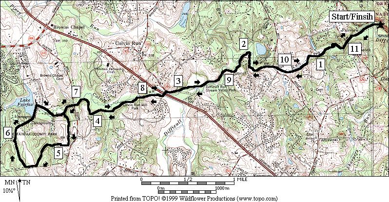
1 Difficult Run Stream Valley Park The more intense mountain bikers have known about for Difficult Run for some time. Equestrians have known it longer. Eight miles of unpaved trail, the Rails to River Trail (RRT), along creeks connects Reston to the Potomac River. Bridges carry most of the busy roads overhead so you re left with miles to enjoy nothing but the woods and the wildlife. The price you have to pay if you re running it is not only the sweat from the distance, but also navigating the waters themselves. Even during July in the drought of 1999, occasional puddles could be found on the trail. Wait until summertime after a long break between rains before attempting this, not only to save yourself some grief from the mud or potential high-water creek crossings (most without bridges), but also to prevent further erosion. Getting There From the Capital Beltway, I-495 Take Exit 13, for Georgetown Pike, Rte. 193, west. After 3.6 miles, turn left into the parking area. As you turn left into the gravel lot, the trail head going south crosses the creek on your right (on stepping stones). The way to the Potomac River north is beyond the gate at the end of the lot after the creek crossing on the right. Area Routes River and Quarry (4.4 or 2.2 miles, IV, or II) For those not ready to test themselves on the way south, a more modest challenge can still be had by going north toward the Potomac River and into Great Falls Park. The first third of a mile is somewhat flat and on the dirt RRT. The trail splits and merges on parallel paths as a result of people trying to avoid the puddles of the flood plain. After crossing under Georgetown Pike, follow the gravel trail downward. You ll drop about 100 feet over the next 0.7 miles if you go all the way to the river. For the longer route, turn left before getting to the river, up a short but steep gravel path to the Ridge Trail. On the ridge, you ll roll over hills but mostly climb to the Old Carriage Road. To make a loop, turn right almost immediately onto the Matildaville Trail (no bikes). You ll be able to catch glimpses of the Mather Gorge and the remains of the Potowmac Canal. The Potowmac Canal operated from 1802 to1828, allowing merchants to get past the 76 foot drop of Great Falls on the river. It took 17 years to build the canal. The trail eventually passes through and old quarry used for making the locks. The quarry has a crater-like appearance. Rocky walls surround a grassy interior. Just past this, turn around to the left, on the Old Carriage Road and return. Difficult Run (11.35 miles, X) Wet Run might be a more appropriate name for this route. The trail stays wet long after rains have past. Don t try it if thunderstorms threaten because you must cross the creek without benefit of bridges several times and the waters can get higher. Previously named the Difficult Run Trail, the trail is now named the Rails to River Trail. It connects the Washington and Old Dominion Trail (W&OD), a former railroad grade, to the Potomac River. Wear a trail shoe if you have one; some are designed not to hold a lot of water and that will help you here. The
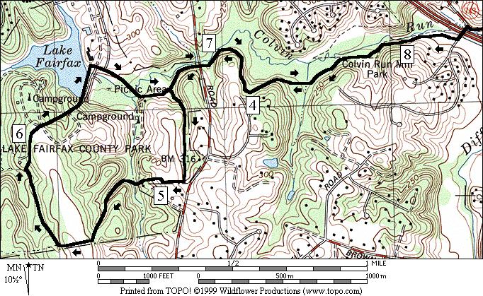
2 heavily wooded trail is for those who are adventurous. It s not been sanitized with improved pavements, drinking fountains or nearby phones. If you wind-up needing help you may have to wait until someone passes by. It s these characteristics that makes the trail so appealing to most who try it. Though the way can be isolated, I happened to come across a group of 15 police officers who were out enjoying themselves on bikes. Bikers with gusto go right to work on this by leaving the parking lot and splashing their way across Difficult Run. It takes a head of speed and some skilled steering to get across because the water is over a foot deep in places. If you re running, you might be able to avoid getting wet just yet. The less enthusiastic can rock hop their way across if the water is low enough and if the rocks, well placed by other passers-by, have not been washed away. Just over a quarter mile upstream, a second crossing must be made. On this one, you ll have the benefit of concrete underfoot. You might be able to jump over the deepest of the water but watch out for it being slippery underneath. The way is flat for the next thee tenths of a mile. Look for a third crossing a hundred yards past the remnants of an old cabin. The crossing is identified by a muddy gully dropping into the water, and the crossing is sharply to the left. If you miss it you ll run into private property. On this crossing, the downstream angle of approach keep you in the shallows but lengthens the crossing. You can t avoid getting wet, unless your on a bike. For the next 1.7 miles, there are no creek crossings and the way continues to be mostly flat. You ll pass Ramey s Meadow Park at Lee Mill Rd. on the way. Jumps are setup at that park for those on horseback. The last creek crossing can be made dryly by rock hopping again. A gravel road after that takes you near Leesburg Pike, Rte. 7. At this point, horses are routed to the left under the highway. Go straight over the road instead. At Leesburg Pike, Rte. 7, cross at a traffic light and begin following Colvin Run. The trail starts climbing more from this point on the way to Lake Fairfax Park. It remains wooded. In Lake Fairfax Park, follow the RRT past the picnic area and fields until you intersect a nature trail identified by red blazes. The nature trail takes you through a campground where you can get a drink. Continuing on, cross the Lake Fairfax dam. Snacks and drinks can be purchased at the pool near the dam. Turning right after the dam, go through a picnic area and return on the RRT. The route through Lake Fairfax Park is hilly.. Return from the picnic area, down Colvin Run and Difficult Run on the RRT. Nearby and Connecting Zones Great Falls National Park, Virginia Reston Lewinsville Park What to do Afterward Food and Drink Café Oggi Greek Taverna Kazan Restaurant picnic Entertainment and Edification Great Falls Grange & Old Schoolhouse - assembly hall & one room school house Colvin Mill - off Leesburg Pike Meadowlark Gardens
3 River and Quarry Distance: Rating: 4.4 or 2.2 miles IV or II; paved trail on the shorter route; roads and hill on the longer one; sunny 4.4 Mile Route 0.0 south from parking lot, through the gate; Rails to River Trail (RRT); go downstream & do not cross creek 0.35 underpass Georgetown Pke, Rte 193 BR 0.4 onto road-like gravel trail; Difficult Run Trail/RRT 0.45 trail X on L <* L 0.9 Ridge Trail(steep gravel trail) L 2.05 trail X on R to River Trail 2.15 at T (unmarked) UL 2.25 just past the quarry; Carriage Rd BL 2.6 to Ridge Tr; Matildaville Tr on L BL 2.65 Ridge Trail 2.7 trail X on R 2.95 River Trail on L (no bikes) 3.3 coral for horses L 0.95 at T to stay on Ridge Trail 1.1 coral for horses 1.45 River Trail on R (no bikes) 1.7 trail X on R R 3.45 down to RRT/Difficult Run Trail; (!) R 3.5 RRT/Difficult Run Trail >* 3.95 trail X on R BR 1.75 before Carriage Rd & stairs on L R 1.8 Matildaville Trail (no bikes) BL 4.0 RRT on L; R is to road 4.05 underpass Georgetown Pke, Rte parking & trail crosses creek on L *2.2 Mile Route S 0.9 Ridge Trail on L goes up steep hill 1.05 trail X U 1.1 Potomac River 1.15 trail X 1.3 Ridge Trail on R goes up steep hill (pickup cues at mile 3.95 on 4.4 mile route)

4 River and Quarry
5 Difficult Run Distance: Rating: miles X; shady, often muddy trails w/wet creek crossings; mostly flat, but hills midway CR 0.0 from parking lot cross Difficult Run on stones (!); go upstream 0.35 cross Diff Run on wet concrete (!) 0.4 underpass Old Dominion Rd 0.6 old cabin L/R 0.65 sharp L at muddy gully; angle downstream to cross Diff Run (!); no bridge (time to get wet) 0.75 trail X on L 0.8 rocky outcrop 1.05 cross stream past house w/chimney 1.15 trail X on L to house 1.45 Leigh Mill Rd; Ramey s Meadow 1.75 trail X on L 2.4 cross Diff Run on stones (!); gravel rd 2.95 concrete bridge; begin paved road; horse trail turns L L 3.1 Colvin Mill Rd; CR 3.15 cross Leesburg Pike, Rte 7; road becomes Carpers Farm Way; R to continue RRT 3.8 wooden bridge 4.05 wooden bridge 4.1 trail X on R 4.4 Hunter Mill Rd; Lake Fairfax Park L 4.5 at split to follow horse trail 4.55 park road X; start climb ahead R 4.95 field at the hilltop; R at the fence 5.0 trail leaves the field; down to creek 5.1 trail on R merges before xing creek 5.3 trail on L merges 5.45 trail X on R 5.5 soccer fields; follow horse trail signs R 5.6 trail X upon entering woods; Nature Trail; red and white blazes R 5.9 gravel road at campground; C gravel road X on L; water/restrooms 6.25 through the gate closing the road to the lake R L BR after xing the dam, go across grass & to road going down to the picnic area 6.65 onto gravel rd after xing Colvin Run at split in the road; toward pavilion L 6.8 gravel road is the RRT BR 6.85 trail X on L merges; leave picnic 6.95 Hunter Mill Rd; leave Lake Fairfax 7.25 trail X on L 7.3 wooden bridge 7.55 wooden bridge L 8.2 Carpers Farm Way; cross Leesburg Pke, Rte 7; becomes; Colvin Mill Rd R 8.25 unmarked service road 8.4 horse trail on R before concrete bridge; follow gravel road S 8.95 cross Diff Run on stones (!); dirt trail 9.6 trail X on R 9.9 Leigh Mill Rd; Ramey s Meadow 10.2 trail X on R to house 10.3 cross stream before house w/chimney 10.6 rocky outcrop; trail X on R afterward L/R10.7 angle upstream to cross Diff Run (!); no bridge (time to get wet again) 10.8 old cabin underpass Old Dominion Rd 11.0 cross Diff Run on wet concrete (!) L cross Diff Run on stones (!); parking

6 Difficult Run
Great Falls National Park, Virginia
 Great Falls National Park, Virginia Despite having grown-up in the area, I had not seen Great Falls until I was near an adult. I used to think places like Great Falls only existed someplace else that you
Rock Creek Park, MD - Lake Needwood
 ock Creek Park, MD - Lake Needwood Lake Needwood, is a reservoir located at the end of the north end of the ock Creek hiker-biker trail. At the other end, ock Creek empties into the Potomac iver near Thompson
Trailside Park, Herndon
 Trailside Park, Herndon Herndon is not the little rail stop it used to be. Like many of the smaller towns around Washington, D.C. Herndon has grown and changed. It even installed it s own little beltway,
Black Hill Regional Park, Little Seneca Lake
 Black Hill Regional Park, ittle Seneca ake ittle Seneca ake, in Black Hill Regional Park, is a reservoir created after a previous drought struck the Washington area. The park is under Maryland-National
Eakin Community Park. Getting There
 Eakin Community Park Quiet woods along the Accotink Creek are the hallmark of Eakin Community Park. Actually a string of smaller parks, Eakin is made-up of Mantua Park, Kern Drive Park, Eakin Park, Woodburn
Columbia, Maryland - Village of Owen Brown
 Columbia, Maryland - Village of Owen Brown From the Village of Owen Brown, good trails stretch to other neighboring Columbia villages. Mostly following stream valleys, the trails go to and from schools
Trailside Park, Ashburn
 Trailside Park, Ashburn For an outsider, Ashburn might seem like a follow-up act to eston. It s a large planned community built at the time, outside the known limits of civilization... Vast farm fields
Vienna. Getting There
 Vienna Like its famous and older German namesake, but on a smaller scale, Vienna, Virginia has a charm to it. Becoming increasingly more cosmopolitan, foreign restaurants, bagle and coffee shops line Maple
Section 7: Pick Up Where You Left Off! S-Tree Road over the Todd Road
 2018 TRACE NOTES Helpful information for your adventure on Section 7 of the Hiker Challenge. Start Point S-Tree Rd. End Point Intersection Todd Rd. / Hale Ridge Rd. WEATHER DECISION Weather Alert!!!! Potential
Jackson Miles Abbott Wetlands Refuge/Fort Belvoir
 Jackson Miles Abbott Wetlands efuge/fort Belvoir Over the course of millions of years the Potomac iver has gradually shifted its course and sediments have filled-in its old river bed. The main river once
Aurora Hills. Getting There
 Aurora Hills Aurora Hills is neighborhood near Crystal City and Pentagon City. Ball fields, ball courts, a very short trail, and a combination ibrary/fire Station are the central pieces of a recreation
Leesburg. Getting There
 eesburg eesburg embodies the historic nature of oudoun County better than does Ashburn. As of 1999, it is on the boundary line of suburbia and the country. It s not only the largest town in oudoun County,
Greenbush Town Hall / Fire Station
 Page 1 of 18 Course Description Greenbush Town Hall / Fire Station Both races start in front of the Greenbush Town Hall / Fire Station, just south of Highway 23 on Sugarbush Road. Parking will be in the
Stephens State Park Trails
 TRAILS OF ALLAMUCHY MOUNTAIN & STEPHENS STATE PARKS Allamuchy Mountain and Stephens State Parks contain 28 marked trails providing access to diverse landscapes for walking, hiking, biking, bird-watching,
UMASS CROSS-COUNTRY Trails
 UMASS CROSS-COUNTRY Trails 1) EGG (43 min) (A) From Cage proceed to North Pleasant street (by campus pond). Make left and head toward LGRT and pass School of Education. Pass Puffton Apt complex (on left)
beach. Make the ford and follow the trail out to the junction with Red Creek Tr in an open grassy area.
 Description: This is a moderate to slightly strenuous 22.8 mile backpack (add 2.6 miles if you do the packless out and back to the Lion s Head) that will have you exploring nearly every thing that is The
Telluride-to-Moab Alternative Singletrack Options
 Telluride-to-Moab Alternative Singletrack Options Day 1 Day 1 Alternate 1: Galloping Goose to Deep Creek. 18.4 miles, ascent 3,530ft, descent 1,388ft. This is fun, flowey, moderate to intermediate singletrack
Lake Artemesia. Getting There
 Lake Artemesia Lake Artemesia is a man-made lake and park located near the confluence of the Indian un, and Paint Branch creeks. A flat 1.3 mile paved path around the lake is popular with walkers, runners
Beaver Creek State Park
 GENERAL INFORMATION Name of Park/Forest/Facility: Beaver Creek State Park County: Columbiana (St. Clair Township) Address: 12816 Sprucevale Road (ie County Rd 428) (street #, city) East Liverpool, Ohio
Tiger Mountain State Forest:
 98 60 hikes within 60 miles: SEATTLE 20 Tiger Mountain State Forest: West Tiger Mountain Three Loop i KEY AT-A-GLANCE INFORMATION Length: 5.1 miles round-trip Configuration: Loop Difficulty: Moderate difficult
Sponsored by. statestreet.com
 /STATESTREETISLANDWALK #ISLANDWALKJSY Sponsored by statestreet.com Important Information If you forget everything else PLEASE remember the following.» Remember to check OUT of every checkpoint» If you
The gorges of Mohican Park in Ohio create a hiker's paradise Sunday, May 22, 2011 By Bob Downing, Akron Beacon Journal
 Pittsburgh Post-Gazette The gorges of Mohican Park in Ohio create a hiker's paradise Sunday, May 22, 2011 By Bob Downing, Akron Beacon Journal Bob Downing Big Lyons Falls drops 80 feet into a shady U-shaped
Exploring the Dumaresq River
 Exploring the Dumaresq River The Dumaresq River (dew merrick) lies on the western side of the Great Dividing Range, the continuous line of mountains that flanks the entire east coast of Australia. The
LAS VARAS RANCH CA COASTAL TRAIL PROPOSED ALIGNMENT
 LAS VARAS RANCH CA COASTAL TRAIL PROPOSED ALIGNMENT Santa Barbara Trails Council * Prepared by Ray Ford February 1,2012 The following notes accompany the Santa Barbara Trails Council map for the Las Varas
Lava Mountain Trail Distance: Elevation Range: Trail Type: Difficulty: Season: Driving Distance: Driving Time: USGS Maps: Pros Cons
 Lava Mountain Trail Distance: 13.4 miles (including the side trip to North Star Lake) Elevation Range: 5900'-8330' Trail Type: singletrack Difficulty: moderate Season: late June-October Driving Distance:
Calvert Regional Park - Tari Moore Recreational Trail. Calvert Regional Park - Woodland Trail. miles from Rising Sun
 Calvert Regional Park - Tari Moore Recreational Trail 304 Brick Meeting House Road, North East, MD 21901 5.2 about 1.1 mile Paved parking lot, plentiful Easy, paved path with slight incline. Easy, paved
Walk 1. Cotswold Water Park. Gateway Centre to Cerney Wick, railway track to Lake 6, Gateway Centre.
 Cotswold Water ark Walk way A Swindon/ Cirencester Thomas and Severn Canal way to Cerney Wick, railway track to Lake, way. Spine Road East Hotel Time: hours (short walk km) Distance: km A level walk along
Central Overland Trail Utah & Nevada Driving Guide, First Edition, 2016
 Central Overland Trail Utah & Nevada Driving Guide, First Edition, 2016 Page 51 In the third paragraph, second sentence, change 0.4 miles to 0.1 miles. In the fourth paragraph, second sentence, change
CWMGIEDD FROM ABERCRAVE
 Abercrave to Cwmgiedd Walk Page 1 Starting from The Abercrave Inn. Grid Ref: SN 824128 From the Abercrave Inn, an 11.3km (7 miles) walk to the foothills of the Cribarth Mountain, then through forest to
West Trails Trek Guide. Chief Pontiac Trail Credential Hikes
 West Trails Trek Guide Kensington Start Edition Chief Pontiac Trail Credential Hikes RDS.WTW.110609 WP# Dist. Accum. Dist. Accum. Feet Miles Meters Meters 1 0 0.0 0 0 2 410 0.1 125 125 3 164 0.1 150 275
Erskine Creek via Pisgah Rock and Jack Evans
 Erskine Creek via Pisgah Rock and Jack Evans 4 hrs 30 mins 7.1 km Circuit Very experienced only 6 421m This walk visits some great lookouts and explores the lower section of Erskine Creek. Most of the
Androscoggin River Trail Access Sites. North Woods. 168 miles from its source at Lake Umbagog to Merrymeeting Bay
 Androscoggin River Trail Access Sites North Woods 168 miles from its source at Lake Umbagog to Merrymeeting Bay Trail Under Construction More than 40 Public Access Sites Available Androscoggin River Watershed
INTERMEDIATE. mayorsmtbchallenge.org
 mayorsmtbchallenge.org Redding s second local Mountain Bike Challenge uniting current and new bicyclists in a friendly self-competition highlighting our diverse trail system. INTERMEDIATE Mule Ridge Cosmos
Oregon Section B - Page m
 Oregon Section B - Page 1 5 35000m 5 36000m 5 37000m 5 38000m 46 57000m 46 58000m Hwy5B - Interstate Highway 5 - mi 1716.4-4271 ft RD1717 - PCT departs paved Old Highway 99 - mi 1716.8-4357 ft PL1717 -
Griffith Park Trail Run Trail Guide Click for
 The Griffith Park Trail Run by Hike- LosAngeles.com Griffith Park Trail Run Trail Guide Click for downloadable cell phone guide and map from EveryTrail. DISTANCE: 4.55 Miles ELEVATION: 1280' ELEVATION
Berowra Waters to Cowan Station
 Berowra Waters to Cowan Station 3 hrs 30 mins 7.2 km One way Hard track 597m This is a hilly walk out of the beautiful Berowra Waters valley to Cowan Station. There are many wide views across Berowra Creek
Guthega to Mt Twynam. 2183m. 1583m. 6 hrs 45 mins 14.8 km Return. Experienced only. 913m
 Guthega to Mt Twynam 6 hrs 45 mins 14.8 km Return Experienced only 5 913m This walk starts from Guthega and makes its way along the Snowy River to the Illawong Lodge, via the Blue Cow Creek flying fox.
Self-Guided Walk Langdale Pikes. Start & Finish: NT car park (free to members) at Sticklebarn - on the right just beyond the New Dungeon Ghyll hotel.
 at Sticklebarn - on the right just beyond the New Dungeon Ghyll hotel.") Self-Guided Walk Langdale Pikes Key Information These mountains form a collection of spires and cliffs on the north side of Langdale. This walk visits four of the main tops Pavey Ark, Harrison Stickle,
Self-Guided Walk Langdale Pikes Key Information These mountains form a collection of spires and cliffs on the north side of Langdale. This walk visits four of the main tops Pavey Ark, Harrison Stickle,
Little Grand Canyon near Pomona, Illinois
 Little Grand Canyon near Pomona, Illinois Below: View of the trail and the terrain created using the Map My Hike app Below: Summary of the hike created using the Map My Hike app Presented by: Jennifer
Skiing and Snowshoes on Un-groomed Fernan Saddle Terrain
 Skiing and Snowshoes on Un-groomed Fernan Saddle Terrain Three ski or snowshoe routes are available from the Fernan Saddle Parking Lot which either do not cover routes ordinarily groomed for snow machine
Trail Phasing Plan. Note: Trails in the Clear Creek Canyon area (Segments will be finalized in the future to minimize wildlife impacts
 Note: Trails in the Clear Creek Canyon area (Segments 2 5 and a future JCOS connection) will be finalized in the future to minimize wildlife impacts Trail Phasing Plan P Parking 3 Easy Trail Intermediate
Trail Accessibility Guide
 Trail Accessibility Guide Programs and Events The s will make every effort, with two weeks advance notice, to provide reasonable accommodations so that people with disabilities may participate in special
Bikes talk to each other like dogs, they wag their wheels and tinkle their bells, the riders let their mounts mingle.
 Bikes talk to each other like dogs, they wag their wheels and tinkle their bells, the riders let their mounts mingle. Daniel Behrman, The Man Who Loved Bicycles W hitmore Lake Loop route: Dexter, the corner
Drive and Stop Routes
 Drive and Stop Routes Limantour Road 1 - easy and likely productive. From Bear Valley Visitor Center drive back out and turn left onto Bear Valley Rd. Turn left at Limantour Road (the first road). Drive
Dadder Cave and Jack Evans track
 Dadder Cave and Jack Evans track 2 Days 10.3 km Circuit Very experienced only 535m This fairly short overnight walk is a great way to explore Erskine Creek. The walking along Erskine creek is mostly off
Directions to Frequently Visited C & O Canal Locations
 Directions to Frequently Visited C & O Canal Locations Seneca Creek Montgomery County, Maryland Pass town of Potomac and Falls Road and continue west to Seneca Rd. Turn left on Seneca Rd. and continue
Beautiful Walks from the Blue Ball Inn
 Walk No. 5 RIVER VALLEYS AND MOOR Countisbury, Watersmeet, Hillsford Bridge, Cheriton, Shilstone Hill, Rockford and Chiselcombe. 8.5 MILES APPROX. Walking time four and a half hours approx. OS 1;25,000
GOLDEN EARS PROVINCIAL PARK
 GOLDEN EARS PROVINCIAL PARK Trail Information as of October 10 th 2015 Do not underestimate the mountainous wilderness of Golden Ears Provincial Park. The combination of rugged terrain and rapidly changing
Mt Kuring-gai Track to Berowra station
 Mt Kuring-gai Track to Berowra station 4 hrs 15 mins 9.7 km One way Hard track 4 553m This walk explores three valleys, with great displays of wild flowers in spring, and some nice sandstone overhangs.
Blackheath to Blue Gum loop
 Blackheath to Blue Gum loop 2 Days Hard track 24.1 km Circuit 4 1335m This walk is great for fit people getting into overnight walking, with its fantastic scenery and nostalgia as a classic overnighter.
Crystal Lake Area Trails
 Lake Area Trails Welcome to the Lake area of the Big Snowy Mountains! This island mountain range in central Montana features peaks reaching to 8,600 feet and long, high ridges from which vistas of the
Victoria Falls Lookout to Blue Gum Forest
 Victoria Falls Lookout to Blue Gum Forest 8 hrs Experienced only 13.8 km One way 5 112m This long day-walk follows a remote track down from Victoria Falls lookout, passing the waterfall, and into the Grose
A Publication of Friends of Sleeping Bear Dunes
 A Publication of Friends of Sleeping Bear Dunes 2014, Friends of Sleeping Bear Dunes, P.O. Box 545, Empire, MI 49630 www.friendsofsleepingbear.org info@friendsofsleepingbear.org Learn more about the Friends
Staunton River Trail to Hoover Camp and Fork Mtn. Relay Tower (Based on September 18, 2013 hike by Ron Singleton, Fredericksburg, Va.
 Staunton River Trail to Hoover Camp and Fork Mtn. Relay Tower (Based on September 18, 2013 hike by Ron Singleton, Fredericksburg, Va.) The President's Cabin (The "Brown" House) at Camp Hoover. Sign on
Matthiessen State Park Dells Area Hike
 90 Easy Hikes Close to Home At the south end of the hike, you ll climb on top of a mound left over from a former coal-mining operation in the park. Not far from Goose Lake Prairie, the town of Morris hosts
The Rains at Kennesaw Mountain - Its Daily Impact
 The Rains at Kennesaw Mountain - Its Daily Impact Sherman wrote that, prior to arriving at Kennesaw Mountain in June 1864, it had rained for 19 straight days. One of his soldiers said 21 days of rain.
The Mendip Way. Route Directions and Maps Uphill to Wells
 The Mendip Way Route Directions and Maps Uphill to Wells Website: www.mendiphillsaonb.org.uk Email: mendip@mendiphillsaonb.org.uk Facebook & Twitter: @MendipHillsAONB Phone: 01761462338 1 Uphill to Loxton
SDTrucksprings. Indiana Off-roading/4x4 Guide Copyright 2015 We Specialize In:
 SDTrucksprings Indiana Off-roading/4x4 Guide Copyright 2015 We Specialize In: Helper Springs Air Bags Leaf Springs Body Lift Kits Coil Springs Timbren Kits Hellwig Springs Lift Blocks And More! Visit www.sdtrucksprings.com
Hiking Las Vegas.com
 Hike: Mt. Wilson via First Creek Canyon route Trailhead: First Creek marked Distance: 10 miles up and back Elevation gain: 3,400 feet Elevation of Peak: 7,070 feet Time: 7 to 9 hours (up and back) Difficulty:
C E N T R A L C A T S K I L L S
 120 C E N T R A L C A T S K I L L S Central Catskills Once out of the southern parts of the Catskills, the Long Path enters the more well traveled and civilized regions. The trail joins the Devil s Path,
Piestewa Peak/Dreamy Draw Trail Guide
 Piestewa Peak/Dreamy Draw Trail Guide Trail #1A - Perl Charles Memorial Trail Length: 4.8 miles Elevation: 2,200 ft. - 1,340 ft. Difficulty: Moderate to difficult The Perl Charles trailhead is located
Girrakool to Wondabyne station
 Girrakool to Wondabyne station 4 hrs Hard track 9.5 km One way 4 438m This walk starts from the Girrakool picnic area and winds south, through the Brisbane Waters National Park. The walk crosses some long
Trail Beginning Elevation: 7553 ft The Poison Creek Trailhead is located at the end of National Forest Road 646E (NF-646E).
.") West Mountain Trails Poison Creek Trail #134 Length: 2.9 miles (4.7 km) Difficulty Horseback: A good trail for the first time west mountain rider, some steep sections Hiking: Most Difficult USGS Maps:
West Mountain Trails Poison Creek Trail #134 Length: 2.9 miles (4.7 km) Difficulty Horseback: A good trail for the first time west mountain rider, some steep sections Hiking: Most Difficult USGS Maps:
BRYCE CANYON COUNTRY Boulder Mountain Scenic backways itinerary
 BRYCE CANYON COUNTRY Boulder Mountain Scenic backways itinerary Boulder Mountain Area The high plateaus of the Aquarius Plateau (Boulder Mountain), are heavily forested and covered in countless winding
Jerusalem Bay Track (Cowan to Brooklyn)
") Jerusalem Bay Track (Cowan to Brooklyn) 5 hrs 30 mins 13.4 km One way Hard track 4 654m This Cowan to Brooklyn Station walk is a popular section of the Great North Walk, with scenery ranging from foreshore
Jerusalem Bay Track (Cowan to Brooklyn) 5 hrs 30 mins 13.4 km One way Hard track 4 654m This Cowan to Brooklyn Station walk is a popular section of the Great North Walk, with scenery ranging from foreshore
Trekking at Peuma Hue
 Trekking at Peuma Hue Peuma Hue is a paradise for those who love hiking and trekking. A large variety of trails cross pristine forest, ancient rocks and stunning waterfalls with beautiful views over the
COURSE DESCRIPTION AND DIRECTIONS
 COURSE DESCRIPTION AND DIRECTIONS START TO BOUNTIFUL B (MILE 0 to MILE 17.05) From the start at East Mountain Wilderness Park, go past the green metal gate of East Mountain Wilderness Park and follow the
BRR Leg 1 (3.9 miles, Easy)
") BRR Leg 1 (3.9 miles, Easy) Min 3901 Max 4919 Ascent +21 Descent -1031 0.0 Start (Grayson Highlands State Park Visitor Center) 3.9 Grayson Highlands State Park Office & Gate, on R (EZ 1) Leg Notes: Minimal
BRR Leg 1 (3.9 miles, Easy) Min 3901 Max 4919 Ascent +21 Descent -1031 0.0 Start (Grayson Highlands State Park Visitor Center) 3.9 Grayson Highlands State Park Office & Gate, on R (EZ 1) Leg Notes: Minimal
Marilla Reservoir to Chestnut Ridge via Marilla Trails and Bullis Hollow Trail east to west
 USGS topographic maps useful to this hike are the Bradford and Stickney 7.5 minute sectionals. These notes are designed to assist in identifying distance and location using geophysical and man-made characteristics
Hadleigh Castle and Chalkwell Oaze
 1 Hadleigh Castle and Chalkwell Oaze Benfleet station Hadleigh Park Hadleigh Castle Leigh-on-Sea Chalkwell station A short stroll through the lush woods of Hadleigh Park high above the Thames-side marshes,
WAGS Tournament Field Directions (October 8-10, 2016)
") WAGS Tournament Field Directions (October 8-10, 2016) Arrowbrook Park (Herndon) 2330 Centreville Rd, Herndon, VA 20171 From the Dulles Toll Road: Take the Herndon/Chantilly exit onto Centreville Road and
WAGS Tournament Field Directions (October 8-10, 2016) Arrowbrook Park (Herndon) 2330 Centreville Rd, Herndon, VA 20171 From the Dulles Toll Road: Take the Herndon/Chantilly exit onto Centreville Road and
Foxhill Park, Bowie, Maryland
 Foxhill Park, Bowie, Maryland The approximately 50,000 residents of the city of Bowie, Maryland are proud of the trails that link the city. Many trails exist and many are planned. Bowie is a changing city.
Camping (Primitive) Camping (RV) Electrical Potable Water Grill Established Fire Pit Picnic Table
 Camping (RV) Electrical Potable Water Grill Established Fire Pit Picnic Table") Alden - 9th Road River Mile 777 Map: 38.20833, -98.32031 Managing Agency: Kansas Department of Wildlife, Parks & Tourism Nearest Community: Alden, Rice County Kansas Developed Amenities Provided Parking
Alden - 9th Road River Mile 777 Map: 38.20833, -98.32031 Managing Agency: Kansas Department of Wildlife, Parks & Tourism Nearest Community: Alden, Rice County Kansas Developed Amenities Provided Parking
Slad over to Pitchcombe and back
 The walk climbs up from Slad over Wickridge Hill, descends to near Pitchcombe, then climbs back over Wickridge hill and round the back of Slad. Page 1 Start Point: SO 8718 0732 The Woolpack, Slad Length:
Great Eastern Trail Newsletter
 Great Eastern Trail Newsletter Volume 1, Number 1, January 2011 By Timothy A. Hupp Please feel free to print out or copy and distribute this newsletter Note this is the first newsletter of the Great Eastern
GREAT SMOKY MOUNTAINS FAMILY CAMP!
 GREAT SMOKY MOUNTAINS FAMILY CAMP! July 10-15, 2017 SCHEDULE OF EVENTS Monday PM 3:00-5:00 EVE 5:45 WELCOME! Arrival, registration and move in to the dorm. Supper 6:45 Welcome & Orientation & Sign Up for
Other Agencies and Organizations
 Daniel Boone National Forest 1700 Bypass Road WInchester, KY 40391 859-745-3100 Location Northern terminus is near Morehead, Kentucky. Southern terminus is located in the Big South Fork NRRA in Tennessee.
Cleveland Photographic Society Amish Country Field Trip Saturday, August 15, 2015
 Cleveland Photographic Society Amish Country Field Trip Saturday, August 15, 2015 Trip Coordinator: Rob Erick 440-570-3352 Feel free to call or text along the way with any questions This trip is planned
CELEBRATE WEST GREENWICH GEOCACHING THROUGHOUT WEST GREENWICH
 CELEBRATE WEST GREENWICH GEOCACHING THROUGHOUT WEST GREENWICH The West Greenwich Land Trust (WGLT) is sponsoring Celebrate West Greenwich, an event designed to celebrate the beauty and history of scenic
ASRA 2018 Hike Schedule
 ASRA 2018 Hike Schedule Date/Day Destination Hike Info Meeting Info Leader Feb 10, Saturday Stagecoach and 9:00 at the Confluence kiosk. Manzanita trails Parking fee required. We ll hike along the trail
CIEC 9 PEAKS AWARD SUPPLEMENT POSSIBLE ROUTES FOR THE 9 PEAKS AWARD TRIP
 CIEC 9 PEAKS AWARD SUPPLEMENT POSSIBLE ROUTES FOR THE 9 PEAKS AWARD TRIP As you plan your trip, be aware of 3 regulations in this wilderness: 1. Camp only in designated campsites. 2. No campfires allowed.
Pontfadog. Walk A. Walk A
 Walk A A Bird s eye view of the village 2km. (1 1 /2 miles); height gain 45m. (150ft) about 45 minutes. Six minutes walk along the main road towards Glyn Ceiriog reach a signpost to Llwynmawr. Take the
Mount Rainier National Park November 2006 Flood Damage
 On November 6 and 7, 2006, Mount Rainier National Park received 18 inches of rain in 36 hours. This presentation summarizes the extensive flood damage that occurred throughout the park. Updated November
Arches of the. Sandflats Area. By Virginia Allen
 Arches of the Sandflats Area By Virginia Allen TABLE OF CONTENTS Introduction Dedication Road Log Arches 1. Perforated View Arch 2. Fee Booth Arch 3. Windsong Arch 4. Weird Arch 5. Resting Arch 6. Bike
Rogue Gorge (Mt. Stella) Roadless Area-- T30S R3E (primarily in portions of Sections 23, 26, 33, 34 & 35)
 Roadless Area-- T30S R3E (primarily in portions of Sections 23, 26, 33, 34 & 35)") Rogue Gorge (Mt. Stella) Roadless Area-- T30S R3E (primarily in portions of Sections 23, 26, 33, 34 & 35) Rogue River-Siskiyou National Forest--High Cascades Ranger District Upper, higher elevation trail
Rogue Gorge (Mt. Stella) Roadless Area-- T30S R3E (primarily in portions of Sections 23, 26, 33, 34 & 35) Rogue River-Siskiyou National Forest--High Cascades Ranger District Upper, higher elevation trail
Baltimore County Nature Quest NEW TRAILS 2014
 Baltimore County Nature Quest NEW TRAILS 2014 Nature Quest Park Locations Robert E. Lee Park Cromwell Valley Park Agricultural Ctr. & Farm Park Honeygo Regional Park Marshy Point Park and Nature Center
Corridor Management Plan for Virginia Coal Heritage Trail WMTH Corporation, 2011, trailsrus.com
 CHAPTER IV: HIGHLIGHTS Along the The St. Paul loop travels over 80 miles through the counties of Russell, Scott, Lee and Wise before ending back at St. Paul. As noted earlier, St. Paul holds the distinction
43 STONE MOUNTAIN LOOP
 204 60 hikes within 60 miles: atlanta 43 STONE MOUNTAIN LOO i KEY AT-A-GLANCE INFORMATION LENGTH: 5.5 miles CONFIGURATION: Loop DIFFICULTY: Easy SCENERY: Views of Stone Mountain and Confederate Memorial;
Merritts Traverse. 1928m
 Merritts Traverse 3 hrs Hard track 5.8 km Circuit 4 167m This walk starts with a scenic journey to the top of the hill on the chairlift. Starting along Merritts Nature walk, this walk soon detours down
Wondabyne station to Somersby Store
 Wondabyne station to Somersby Store 10 hrs Hard track 26.2 km One way 4 1164m This walk, following a section of the Great North Walk, starts from the Wondabyne train station and winds north, into the Brisbane
East West route and Leatham Molesworth route (route guide) Molesworth Recreation Reserve
 Molesworth Recreation Reserve") East West route and Leatham Molesworth route (route guide) Molesworth Recreation Reserve 0BIntroduction The East West route links the Clarence (Kahutara River in Ka Whata Tu o Rakihouia) Conservation Park
East West route and Leatham Molesworth route (route guide) Molesworth Recreation Reserve 0BIntroduction The East West route links the Clarence (Kahutara River in Ka Whata Tu o Rakihouia) Conservation Park
Asheville & WNC Hikes
 Asheville & WNC Hikes Amazingly, we have 3,000+ miles of free public hiking trails near Asheville, including 1,600 miles in the Pisgah and Nantahala National Forests, 850 miles in Great Smokey Mountains
Route #2) Mt. Massive - Southwest Slopes
 Mt. Massive - Southwest Slopes") Route #2) Mt. Massive - Southwest Slopes Difficulty: Class 2 Ski: Advanced, D6 / R2 / III Exposure: Summit Elevation: Trailhead Elevation: Elevation Gain: Round-trip Length: Trailhead: County Sheriff:
Route #2) Mt. Massive - Southwest Slopes Difficulty: Class 2 Ski: Advanced, D6 / R2 / III Exposure: Summit Elevation: Trailhead Elevation: Elevation Gain: Round-trip Length: Trailhead: County Sheriff:
Blue Ridge Hiking Club - First Quarter 2018 Hikes
 Blue Ridge Hiking Club - First Quarter 2018 Hikes Monday, Jan 1: Trout Lake to Manor House & Figure 8 Trail: Meet at Trout Lake parking lot, at 9:30. (1st exit left off Parkway just south of Cone Manor
S H A W A N G U N K R I D G E T R A I L
 214 Shawangunk Ridge Trail The Shawangunk Ridge Trail was originally conceived as a relocation of the Long Path from Harriman State Park to Minnewaska State Park. Now part of the Long Path system, the
The Croatan MST Segment 16B
 1 Mountains-to-Sea Trail Last Updated 1/1/2017 A sandy road through longleaf pine savanna in the Croatan National Forest Photo by PJ Wetzel, www.pjwetzel.com The Croatan MST Segment 16B STELLA TO THE NEUSIOK
Discover. Ashhurst Domain. Nature s Playground
 Discover Ashhurst Domain Nature s Playground Discover Step back into New Zealand, Aotearoa, of generations long gone. Discover lush natural surrounds echoing with rich birdsong in one of the Manawatu s
San Luis Obispo. Bishop Peak Felsman Loop Eagle Rock Maino Open Space Poly Canyon Poly P Other Areas
 San Luis Obispo Bishop Peak Felsman Loop Eagle Rock Maino Open Space Poly Canyon Poly P Other Areas 1 JCT. ELEV. 72 400 00 0 FELSMAN LOOP GATE LOOP RIDGE 600 FENCE JCT. ELEV. 860 1000 1200 BISHOP PEAK
United States Department of the Interior National Park Service. Boundary Expansion Listed in National Register January 11, 2017
 NPS Form 10900-a (Rev. 8/2002) OMB No. 10240018 United States Department of the Interior National Park Service Boundary Expansion Listed in National Register January 11, 2017 National Register of Historic
BACKROADS BICYCLE/AUTOMOBILE TOUR OF MIDDLESEX, VERMONT
 BACKROADS BICYCLE/AUTOMOBILE TOUR OF MIDDLESEX, VERMONT (created and published by the Middlesex Historical Society) Welcome to a 25-mile self-guided historical tour of the backroads of Middlesex. You may