Lake Manitou Dam and Spillway Upgrade
|
|
|
- Norman Alexander
- 5 years ago
- Views:
Transcription


1 South Bend Lake Manitou Dam and Spillway Upgrade Fort Wayne Rochester Indiana 1828 to 2017 Lafayette Sky Medors, P.E., LFA David Nance, P.G., IDNR

2 Project Background Location: Rochester Indiana, Central Northern Indiana. Primary purpose, At Construction: Hydropower mill operations; Recently: Recreational use only Dam: completion date 1827 Height: 10 feet Dam length 400 feet Maximum storage 3,875 Ac-Ft Surface area acres Crest width: 10 feet Drainage area 44.2 square miles Owner: City of Rochester, 1992 maintance agreement with IDNR

3 Lake Manitou Dam, 190 Years, History
4 Key Elements Reference Map N Public Park & Beach Public Access Auxiliary Dam Spillway Lake Manitou


5 Indiana Floodplain Information Portal indnr.maps.arcgis.com Hospital
6 Flood of Record* Flood Event: August 18 23, 1990 Crest , NGVD 29 = NAVD 88 Secondary Event, December 1990 Crest NGVD 29 = NAVD 88 Court Established level is NGVD 29 = NAVD 88 Weir Design Level (average of preexisting) NGVD 29 = NAVD 88 Auxiliary Spillway Design Level NGVD 29 = NAVD 88 Crest of North Embankment NAVD 88 *Design and NFIP maps are based on the NAVD 88 Datum Test USGS data records and Court Establishment are based on NGVD 29 Datum larger value than NAVD 88 Agreement, City of Rochester and IDNR February 1991 City of Rochester and the Department of Natural Resources. The Department assumes the sole responsibility for the revisions, maintenance, and repair of the control section and the repair of the adjoining embankments of the structure. Further, the Department will design, construct and fund the necessary revisions [for] a control section and adjoining embankments. The City agrees to be responsible for all annual routine maintenance.. In the agreement the City is also to provide ingress and egress to the Department.

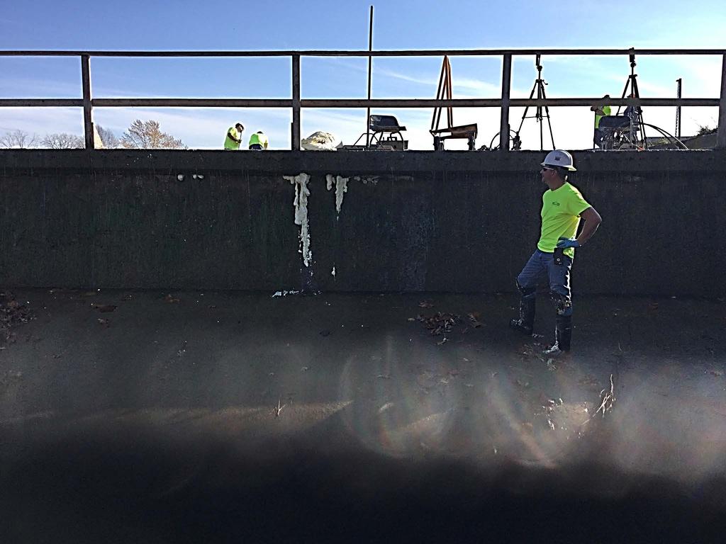
7 Response: Winter Repairs Recent History
8 IEAP, Compiled, 2014, Presented to the City Summer of 2015 Indiana Office of Community and Rural Affairs Grant
9 IEAP, breach analysis completed in 2014 and presented to the City in the 2015
10
11
12
13

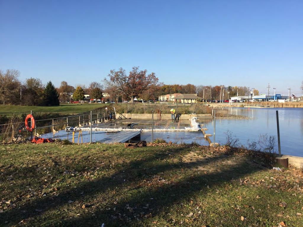
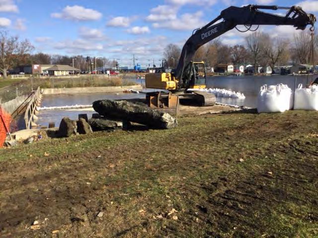
14 2015 Brush Clearing North Embankment, Before Auxiliary Spillway Spillway North fence


15 2015 Brush Clearing North Embankment, After Auxiliary Spillway Spillway

16 August 2015, Before Brush Clearing, During Geotechnical Data Collection

17 April 2016, After Brush Clearing, Photos/160420_N-access

18 August 2015, Before Brush Clearing, During Geotechnical Data Collection

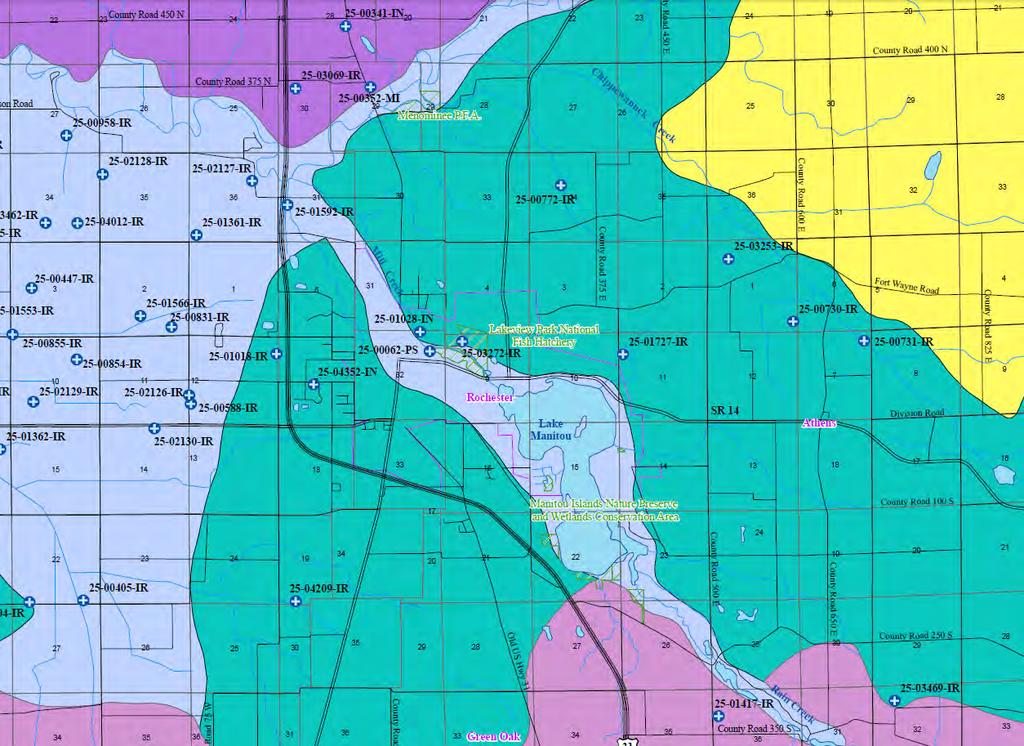
19 September 2015, After Brush Clearing

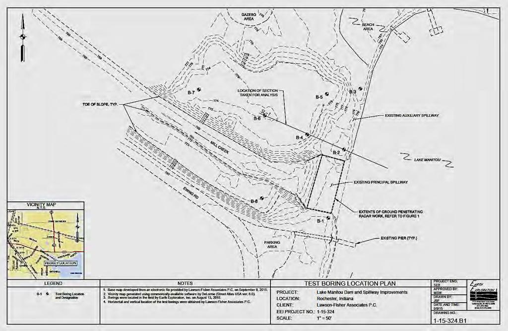
20 September 2015, After Brush Clearing

21 September 2015, After Brush Clearing

22 September 2015, After Brush Clearing

23 Regional Geology
24

25

26 Map of Indiana Showing Near-Surface Aquifer Sensitivity Sally L. Letsinger Miscellaneous Map 93 Indiana Geological Survey
27 Geotechnical Evaluation, 2015
28

29

30 Concrete Spillway Evaluation, 2015

31 Design Plans, 2016
32 Key Elements Reference Map N Public Park & Beach Public Access Auxiliary Dam Spillway Lake Manitou
33

34

35
36
37
38
39
40
41
42

43 December 1

44 December 13

45 December 13

46 December 28 Site is stabilized for the Winter
47 Winter Break

48 Key Elements Reference Map N Public Park & Beach Public Access Auxiliary Dam Spillway Lake Manitou
49

50 March 16-21, 2017

51 March 22, 2017

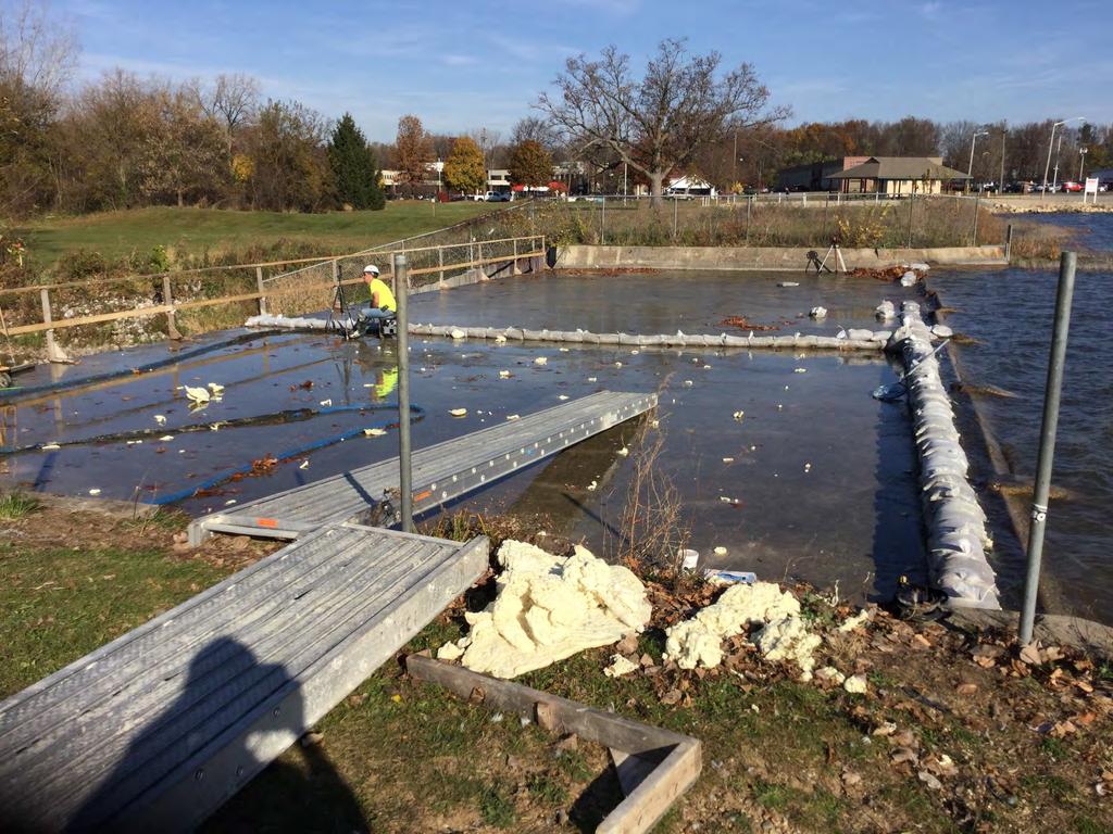
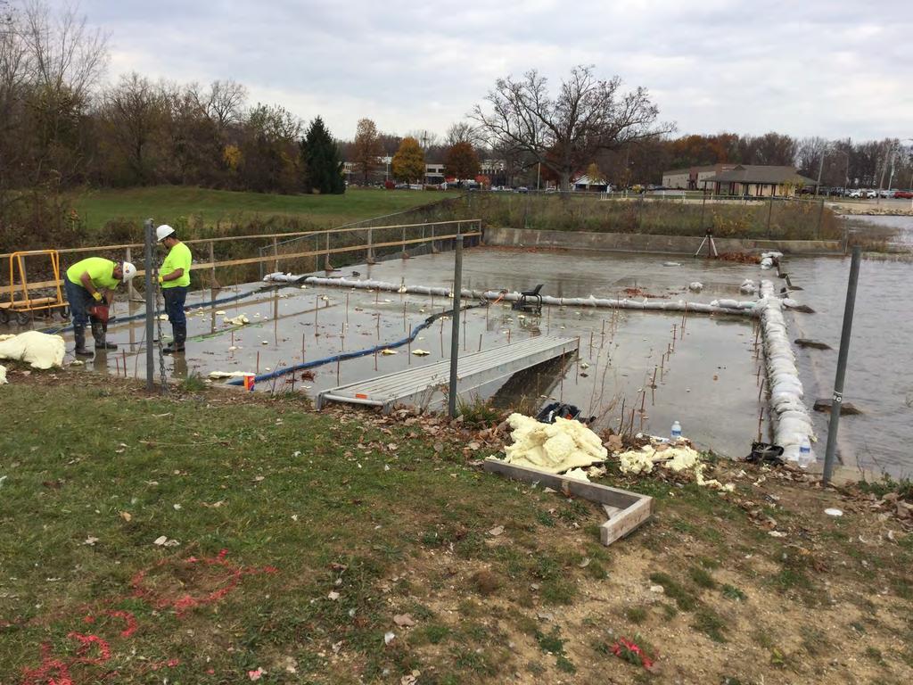
52 March 22, 2017
53 March 22, 2017 Unknown History Can Change Plans Decide, Document, and Move On

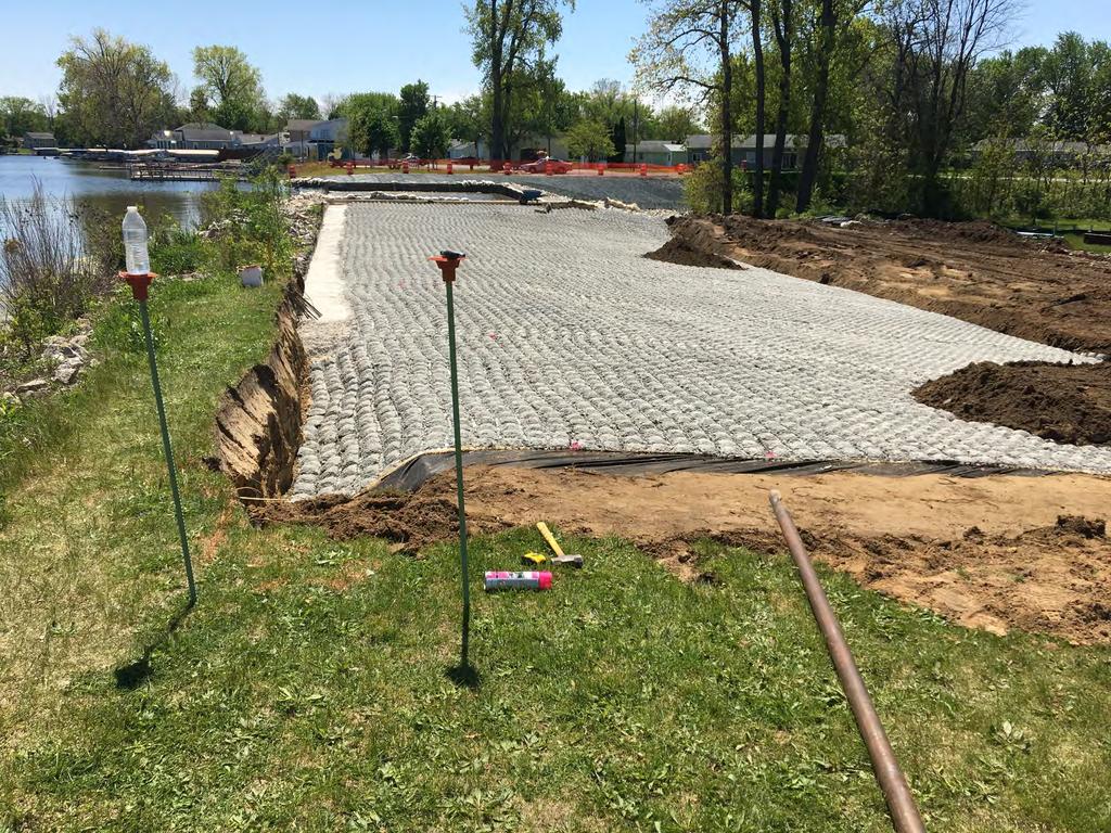
54 March 23, 2017 South Wall Steel Sheet Piling Complete

55 March 31, 2017 South Wall Complete

56 April 6, 2017 North Wall Steel Sheet Piling Complete, Ready for Concrete

57 April 12, 2017
58

59 April 12, 2017 North Embankment & Auxiliary Spillway
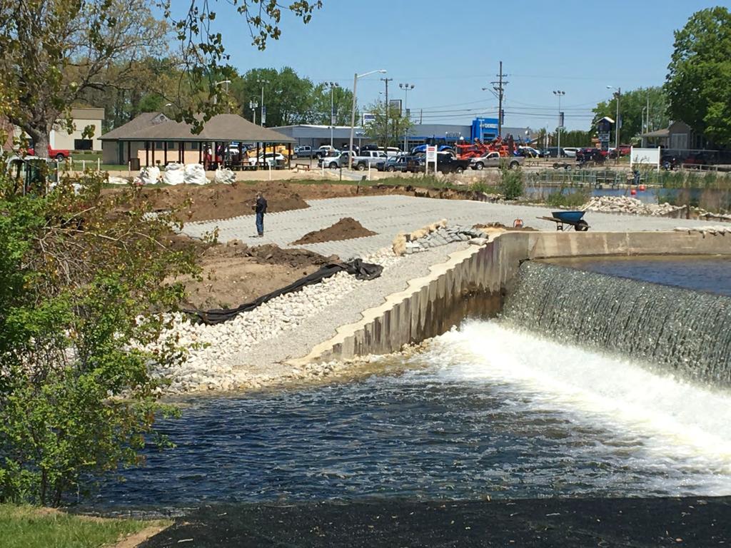
60

61 May 8, 2017


62 Flexamat Erosion Control Use and Placement May 8, 2017

63 May 8, 2017

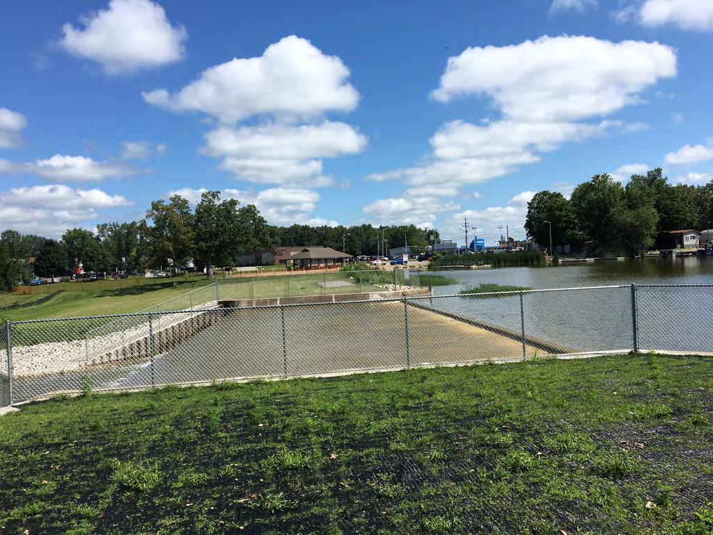
64 May 18, 2017

65 May 18, 2017

66 July 15, 2017 Auxiliary Spillway Spillway

67 July 15, 2017 Auxiliary Spillway
 July 15,")
68 Spillway Complete (panoramic) July 15, 2017

69 July 15, 2017 HPTRM,
70

71 August 23, 2017

72 August 23, 2017

73 August 23, 2017

74 August 23, 2017

75 August 23, 2017

76 August 23, 2017


77 After Auxiliary Spillway Spillway July 2017 North Embankment and Auxiliary Spillway Before Auxiliary Spillway Spillway September 2015


78 Lake Manitou Dam and Spillway Upgrade Public Park & Beach Questions Public Access? Auxiliary Spillway Dam Spillway Lake Manitou Sky Medors, P.E., LFA David Nance, P.G., IDNR
79
DRAFT GENERAL IMPLEMENTATION PLAN AND SPECIFIC IMPLEMENTATION PLAN MIDDLETON MUNICIPAL AIRPORT MOREY FIELD. Revised 12/12/03
 DRAFT GENERAL IMPLEMENTATION PLAN AND SPECIFIC IMPLEMENTATION PLAN MIDDLETON MUNICIPAL AIRPORT MOREY FIELD Revised 12/12/03 As recommended for approval by the Plan Commission General Project Description
THE LEVEES OF DALLAS COUNTY
 THE LEVEES OF DALLAS COUNTY Jessica Baker, EIT, CFM Walter Skipwith, P.E. Steve Parker, P.E., CFM TFMA 2008 Spring Conference League City, TX May 1, 2008 Introduction Map Modernization Program Certification
City of Fort Lauderdale. Frequently Asked Questions. Proposed Sea Wall Ordinance
 City of Fort Lauderdale Frequently Asked Questions Proposed Sea Wall Ordinance The City of Fort Lauderdale is considering amending the Unified Land Development Regulations of the City of Fort Lauderdale
ORDINANCE NO. C-16- WHEREAS, the proposed minimum seawall elevation exceeds the current maximum by 0.7 feet (8.4 inches); and
; and") ORDINANCE NO. AN ORDINANCE AMENDING THE UNIFIED LAND DEVELOPMENT REGULATIONS OF THE CITY OF FORT LAUDERDALE, FLORIDA, AMENDING SECTION 47-19.3, BOAT SLIPS, DOCKS, BOAT DAVITS, HOISTS AND SIMILAR MOORING
ORDINANCE NO. AN ORDINANCE AMENDING THE UNIFIED LAND DEVELOPMENT REGULATIONS OF THE CITY OF FORT LAUDERDALE, FLORIDA, AMENDING SECTION 47-19.3, BOAT SLIPS, DOCKS, BOAT DAVITS, HOISTS AND SIMILAR MOORING
DEVIL CANYON PROJECT RELICENSING FERC PROJECT NUMBER TRANSPORTATION SYSTEM MANAGEMENT PLAN November 2018
 DEVIL CANYON PROJECT RELICENSING FERC PROJECT NUMBER 14797 TRANSPORTATION SYSTEM MANAGEMENT PLAN November 2018 State of California California Natural Resources Agency DEPARTMENT OF WATER RESOURCES Hydropower
Mr. Michael Malone CPS Energy 145 Navarro Street San Antonio, Texas Project No
 January 15, 2016 Mr. Michael Malone 145 Navarro Street San Antonio, Texas 78205 Project No. 0328985 Environmental Resources Management CityCentre Four 840 West Sam Houston Pkwy N. Suite 600 Houston, Texas
Section 61 Recreational Vehicle Park / Campground (Bylaw No. 2012/10)
") Part 7 General Regulations Section 61 Recreational Vehicle Park / Campground (Bylaw No. 2012/10) 61.1 A comprehensive site plan shall be provided to the satisfaction of the Development Authority that shows
Part 7 General Regulations Section 61 Recreational Vehicle Park / Campground (Bylaw No. 2012/10) 61.1 A comprehensive site plan shall be provided to the satisfaction of the Development Authority that shows
SECTION 3 GENERAL DESCRIPTION OF THE RIVER BASIN
 SECTION 3 GENERAL DESCRIPTION OF THE RIVER BASIN SECTION 3 GENERAL DESCRIPTION OF THE RIVER BASIN River basin description. A general description of the river basin or subbasin, as appropriate, in which
Cofferdam Performance Hurricanes Harvey & Irma
 Cofferdam Performance Hurricanes Harvey & Irma - 2017 Greg Hammer Senior Geotechnical Engineer CELRH-DSPC-GS DSMMCX Third Workshop on Case Histories in Dam Safety Risk-Informed Decision Making 2018 USSD
Study Tour C: Swaziland and Kruger National Park (Pre-tour) 11 to 15 May 2016
 11 to 15 May 2016") Study Tour C: Swaziland and Kruger National Park (Pre-tour) 11 to 15 May 2016 Introduction This tour combines scenic routes in neighbouring country Swaziland with game watching in the Kruger National Park.
Study Tour C: Swaziland and Kruger National Park (Pre-tour) 11 to 15 May 2016 Introduction This tour combines scenic routes in neighbouring country Swaziland with game watching in the Kruger National Park.
Hydro-Electric Schemes Compliance Report June June 2013
 File Reference: 4.00212 Significance of Decision: Receives Only - No Decisions Report To: Operations, Monitoring and Regulation Committee Meeting Date: 20 June 2013 Report From: Nick Zaman, Pollution Prevention
U.S. DEPARTMENT OF COMMERCE National Oceanic and Atmospheric Administration National Ocean Service Datums Page Page 1 of 5
 Datums Page Page 1 PRIMARY BENCH MARK STAMPING: 2245 A 1982 866 2245 A TIDAL MONUMENTATION: Tidal Station disk VM#: 16408 AGENCY: National Ocean Survey (NOS) PID#: DD1345 The primary bench mark is a disk
Principle Causes of Dam Failures. Structural failure. Cracking. Stability failure. BIA Summer Water Resources Training Dam Safety Inspections
 BIA Summer Water Resources Training Dam Safety Inspections Principle Causes of Dam Failures Part 2 Dam Failures July 28, 2012 Presented by Michael Johnson, Ph.D., P.E. Overtopping Structural failure Stability
Hydraulic Report. Trail 5 Snowmobile Trail Over Mulligan Creek. Prepared By: COLEMAN ENGINEERING COMPANY Karisa V. Falls, P.E.
 Prepared for: Prepared by: Marquette County Road Commission Coleman Engineering Company Marquette, Michigan Iron Mountain, MI December 2011 Hydraulic Report Trail 5 Snowmobile Trail Over Mulligan Creek
Section XIII. Cost Estimates
 Section XIII Cost Estimates 13-01. INTRODUCTION SECTION XIII COST ESTIMATES a. General. Preliminary cost estimates for development of proposed new and renovation or replacement actions at Lake Shelbyville
Appendix 4 St. Charles Basin
 Appendix 4 St. Charles Basin The St. Charles hurricane protection system (HPS), shown in Figure 1, was designed as part of the Lake Pontchartrain, LA, and Vicinity Hurricane Protection Project. The St.
North Cruise Berth Projects PortMiami
 North Cruise Berth Projects PortMiami AAPA 2017 Facilities Engineering Seminar Oct 24 26, 2017 Carlos J. Arboleda, PE Vice President Project Director Intermodal Ports 1 PortMiami The Cruise Capital of
International Osoyoos Lake Board of Control Annual Report to the International Joint Commission
 International Osoyoos Lake Board of Control 2010 Annual Report to the International Joint Commission TABLE OF CONTENTS ACTIVITIES OF THE BOARD... 1 HYDROLOGIC CONDITIONS IN 2010... 2 Drought Criteria...
International Osoyoos Lake Board of Control Annual Report to the International Joint Commission
 International Osoyoos Lake Board of Control 2013 Annual Report to the International Joint Commission TABLE OF CONTENTS ACTIVITIES OF THE BOARD... 1 HYDROLOGIC CONDITIONS IN 2013... 2 Drought Criteria...
Appalachian Power Company Smith Mountain Hydroelectric Project FERC No Debris Management Plan
 Appalachian Power Company Smith Mountain Hydroelectric Project FERC No. 2210 Debris Management Plan Final July2008 TABLE OF CONTENTS Description Page SUMMARY 1 1.0 Introduction.. 2 1.1 Project Lands and
Agenda Report. Spruce Street Outlet Drainage Improvements Tower Road Relief Sewer
 Agenda Report Subject: Prepared By: Spruce Street Outlet Drainage Improvements Tower Road Relief Sewer Steven M. Saunders, Director of Public Works/Village Engineer Date: August 12, 2012 On March 8, 2012
PROPOSED ACTION South 3000 East Salt Lake City, UT United States Department of Agriculture
 United States Department of Agriculture Forest Service Uinta-Wasatch-Cache National Forest Salt Lake Ranger District 6944 South 3000 East Salt Lake City, UT 84121 801-733-2660 File Code: 1950/2300 Date:
Application for Permit to Develop in a Floodplain Area
 Application for Permit to Develop in a Floodplain Area The undersigned hereby makes application for a permit to develop in a designated floodplain area. The work to be performed is described below and
Rule Governing the Designation and Establishment of All-Terrain Vehicle Use Trails on State Land
 Rule Governing the Designation and Establishment of All-Terrain Vehicle Use Trails on State Land 1.0 Authority 1.1 This rule is promulgated pursuant to 23 V.S.A. 3506. Section 3506 (b)(4) states that an
^ox, 7. Environment Agency. Hayling Island North Strategy *. M ^, v. * > -.
 ^ox, 7 Environment Agency Hayling Island North Strategy *. M ^, v. * > -. Consultation Document for Preferred Coastal Defence Options - Septem ber 2005 We are the Environment Agency. It s our job to look
The Galveston Seawall
 Coastal and Ocean Engineering ENGI.8751 Undergraduate Student Forum Faculty of Engineering and Applied Science, Memorial University, St. John s, NL, Canada. March, 2013 The Galveston Seawall Mark Harvey
Initial OPW Designation APSR AFRR IRR Co-ordinates Easting: Northing: River / Catchment / Sub-catchment Type of Flooding / Flood Risk
 Location: Shannon International Airport, Co. Clare Unique ID: 275484 (from PFRA database) Initial OPW Designation APSR AFRR IRR Co-ordinates Easting: 137674 Northing: 161045 River / Catchment / Sub-catchment
PHOTOGRAPHS WRITTEN HISTORICAL AND DESCRIPTIVE DATA
 Spanning Coon Creek Hulah Vicinity Osage County Oklahoma PHOTOGRAPHS WRITTEN HISTORICAL AND DESCRIPTIVE DATA HISTORIC AMERICAN ENGINEERING RECORD Submitted to: Oklahoma State Historic Preservation Office
Projected Advertisement Date
 2013 Planned s CY 2013 and CY 2014 Richmond District Schedule Preliminary Engineering Task Order Contracts SR 288/SR 145 Survey, 288 90349 Chesterfield Ramp and Signal Design 2/27/2013 $ 0.19 I-64 Over
Duncan Hastie, P.E. Dewberry
 FEMA s Riverine High Water Marks for Atlanta s September 2009 Flood Event Duncan Hastie, P.E. Dewberry Background High Water Mark Recovery Performed Through FEMA s Hazard Mitigation Technical Assistance
Sandbag Barrier. Suitable Applications Sandbag barriers may be suitable: As a linear sediment control measure:
 Categories EC Erosion Control SE Sediment Control TC Tracking Control WE Wind Erosion Control Non-Stormwater NS Management Control Waste Management and WM Materials Pollution Control Legend: Primary Category
Porter Fk. #1. All unauthorized items removed as per FS & Rec Res guidelines. Footbridge may be needed for wheel chair access and for safety
 APPENDIX D Lot Specific Permit Compliance & Forest Plan (FP) Requirements Porter Fork Recreation Residence Tract (Items noted were documented in compliance letter, 8/12/2005, sent to all Rec. Residence
[Internal Agency Docket Nos. FEMA-B-7759, FEMA-B-1138 and FEMA-B-1208] AGENCY: Federal Emergency Management Agency, DHS.
![[Internal Agency Docket Nos. FEMA-B-7759, FEMA-B-1138 and FEMA-B-1208] AGENCY: Federal Emergency Management Agency, DHS.](/thumbs/78/78195509.jpg "[Internal Agency Docket Nos. FEMA-B-7759, FEMA-B-1138 and FEMA-B-1208] AGENCY: Federal Emergency Management Agency, DHS.") This document is scheduled to be published in the Federal Register on 11/07/2012 and available online at http://federalregister.gov/a/2012-27116, and on FDsys.gov 1 Billing Code 9110-12-P DEPARTMENT OF
This document is scheduled to be published in the Federal Register on 11/07/2012 and available online at http://federalregister.gov/a/2012-27116, and on FDsys.gov 1 Billing Code 9110-12-P DEPARTMENT OF
Clayfaulds Farm, Bonnybridge, Stirlingshire, FK4 2HA. Offers over 450,000
 Clayfaulds Farm, Bonnybridge, Stirlingshire, FK4 2HA Offers over 450,000 Particulars of Sale Junction 6A M80 2 miles, Bonnybridge 2.5 miles, Denny 4 miles, Falkirk 6 miles, Cumbernauld 7 miles, Stirling
Damn those dams their effects on stream ecosystems
 Damn those dams their effects on stream ecosystems Jeremy Tiemann Illinois Natural History Survey Prairie Research Institute at the University of Illinois History of dams History of dams First evidence
ROYAL VIEW DEVELOPMENT
 GRETNA BUILDING FOR LEASE ROYAL VIEW DEVELOPMENT PROPOSED RENDERINGS AVAILABLE FOR PRE-LEASE + + LEASE RATE AND AVAILABILITY MINIMUM SPACE: MAXIMUM SPACE: LEASE RATE: 1,278 SF 16,500 SF $16.50 - $22.00
Decision Memo for Desolation Trail: Mill D to Desolation Lake Trail Relocation
 for Salt Lake County, Utah Uinta-Wasatch-Cache National Forest Salt Lake Ranger District 1. Background The present location of the Desolation Trail (#1159) between Mill D and Desolation Lake follows old
2. SECTOR Energy 1. PROJECT TITLE LOWER VRBAS HYDROPOWER PLANTS
 1. PROJECT TITLE LOWER VRBAS HYDROPOWER PLANTS. SECTOR Energy 3. LOCATION The lower course of the Vrbas, i.e. the stretch from the city of Banja Luka to the mouth of the Vrbas, is planned to accommodate
SOUTH AFRICAN NATIONAL COMMITTEE ON LARGE DAMS BIENNIAL CONFERENCE 8-10 November 2011 Management and Design of Dams in Africa
 SOUTH AFRICAN NATIONAL COMMITTEE ON LARGE DAMS BIENNIAL CONFERENCE 8-10 November 2011 Management and Design of Dams in Africa What s new: For list of papers see p4 About the Conference The South African
2011 Nags Head Beach Nourishment Project Update. Tim Kana & Haiqing Kaczkowski
 2011 Nags Head Beach Nourishment Project Update Tim Kana & Haiqing Kaczkowski NCBIWA Conference 3 April 2017 Outline of the Presentation 1 Review 2011 Nourishment Project Post-project monitoring efforts
EAST SIDE TRANSPORTATION INITIATIVE APEGM SEPTEMBER 9, 2009
 EAST SIDE TRANSPORTATION INITIATIVE APEGM SEPTEMBER 9, 2009 EAST SIDE TRANSPORTATION INITIATIVE AREA First Nations Northern Affairs Communities Metis Peoples PROCESSES EAST SIDE ROAD AUTHORITY (ESRA) CROWN
Project Overview. Hunter Mill Road Over Colvin Run Bridge Replacement Fairfax County. Get Involved. Public Information Meeting. Contact Information
 Get Involved VDOT representatives will review and evaluate any information received as a result of the public information meeting. The comment sheet in this brochure is provided to assist in making your
Outer Banks Bridges Update:
 Outer Banks Bridges Update: Outer Banks Chamber of Commerce Economic Summit Jerry D. Jennings, PE - Division Engineer April 12, 2018 Mid-Currituck Bridge Currituck Sound (Wright Memorial Bridge) Alligator
State Level Historic Documentation Report. John Blue Bridge Hampshire County
 State Level Historic Documentation Report State Project No. S314-28-22.27 Federal Project No. BR-0028(058)D John Blue Bridge Hampshire County Prepared by: Randy Epperly, Historian Department of Transportation
EAST DON TRAIL ENVIRONMENTAL ASSESSMENT. Community Liaison Committee Meeting #3 July 15, :30 to 8:30 pm Flemingdon Park Library
 EAST DON TRAIL ENVIRONMENTAL ASSESSMENT Community Liaison Committee Meeting #3 July 15, 2013 6:30 to 8:30 pm Flemingdon Park Library Agenda 1. Welcome 2. Housekeeping and Updates a) Housekeeping b) CLC
Uinta-Wasatch-Cache National Forest Salt Lake Ranger District
 United States Department of Agriculture Forest Service Uinta-Wasatch-Cache National Forest Salt Lake Ranger District 6944 South 3000 East Salt Lake City, UT 84121 801-733-2660 File Code: 1950/2300 Date:
Bradley Brook Relocation Project. Scoping Notice. Saco Ranger District. United States Department of Agriculture Forest Service
 Bradley Brook Relocation Project United States Department of Agriculture Forest Service Scoping Notice White Mountain National Forest February 2011 For Information Contact: Jenny Burnett White Mountain
Assessing Your Trails, Keeping Them Safe and Enjoyable
 Jon Wood, PLA, ASLA Associate Vice President Stewart Bert Lynn, PLA, ASLA, LEED AP Project Manager Mecklenburg County Asset and Facility Management Assessing Your Trails, Keeping Them Safe and Enjoyable
Trail Feasibility Study
 VOLUSIA COUNTY MPO CITY OF NEW SMYRNA BEACH FINAL REPORT JUNE 30, 2009 Trail Feasibility Study What s inside? 1 Introduction 2 Project Purpose & Scope 3 Physical Inventory & Assessment of Right-of- Way
Navigating Indiana Road Signage
 Navigating Indiana Road Signage JOE BRUNO Traffic Administration Engineer Indiana Department of Transportation Presentation Overview Background Logo Program (Gas, Food, Lodging, & Camping Services) Attraction
Wilts & Berks Canal. Appendix E: Hydrology and Hydraulics CONTENTS 1. INTRODUCTION 2 2. HYDROLOGY 2 3. HYDRAULIC MODEL 2 4.
 Wilts & Berks Canal Melksham River Route Study Appendix E: Hydrology and Hydraulics CONTENTS 1. INTRODUCTION 2 2. HYDROLOGY 2 3. HYDRAULIC MODEL 2 4. CANAL OPERATION 3 5. WEIR DESIGN 4 6. FLOOD RISK 5
State Route 8 Corridor. Northern Summit County s Path to Success
 State Route 8 Corridor Northern Summit County s Path to Success Construction Guide: 2008-2009 State Route 8 corridor work description State Route 8 Corridor 10 projects $262 million With its close proximity
Outline of the Shinryu Head Works
 Outline of the Shinryu Head Works Midori Network Water and farmland protection Midori Network Shinryu 1. History Land reclamation began in 1890 under the initiative of the Uryu Aristocratic Farm, headed
1. The scour elevation can normally be found on the bridge hydraulics sheet and in the Pile Data Table. True False
 Homework 1 1. The scour elevation can normally be found on the bridge hydraulics sheet and in the Pile Data Table. True False 2. The Required Nominal Bearing Resistance Resistance will normally be shown
Version Isolated & Non-Waters Only 1 of 3
 APPROVED JURISDICTIONAL DETERMINATION FORM U.S. Army Corps of Engineers SECTION I: BACKGROUND INFORMATION A. REPORT COMPLETION DATE FOR APPROVED JURISDICTIONAL DETERMINATION (JD): July 6, 2010. B. DISTRICT
Permeable RECREATIONAL TRAILS
 SMART EARTH SOLUTIONS Permeable RECREATIONAL TRAILS GEOWEB GEOPAVE GEOTERRA Innovative Solutions for Designing & Building Trails. Trail Surface Stabilization The key to planning and building trails into
Lake Wissota Access Locations within the LaFayette Township. By Chad Martin
 Lake Wissota Access Locations within the LaFayette Township By Chad Martin Anson/ Wissota Access Point # 1 Road: 195 th St. Associated Fire Numbers: 13294 Defining Characteristics: Forested from road
GOULS FARM, GLASS, BY HUNTLY, ABERDEENSHIRE, AB54 4YL.
 GOULS FARM, GLASS, BY HUNTLY, ABERDEENSHIRE, AB54 4YL. This stock rearing Farm is well located in an unspoilt area with traditional farmhouse and buildings and is For Sale as a whole. SITUATION:- Gouls
Spencer Environmental Appendix A: Alternative Analysis for Construction Access Route
 Spencer Environmental Appendix A: Alternative Analysis for Construction Access Route February 2015 Valley ine-stage 1 RT EISA Update FINA REPORT Page A1 Memorandum AECOM ConnectEd Transit Partnership 10235
Sales Associate Course
 Sales Associate Course Chapter Nineteen Planning, Zoning and Environmental Hazards Copyright Gold Coast Schools 1 Government Planning Planning in U.S. dates back to the colonial period Government did not
DAMAGE ASSESSMENT OF SAND FENCING GARDEN CITY, NORTH LITCHFIELD AND LITCHFIELD BEACH GEORGETOWN COUNTY, SC
 OF SAND FENCING GARDEN CITY, NORTH LITCHFIELD AND LITCHFIELD BEACH GEORGETOWN COUNTY, SC June 07, 2017 PREPARED FOR: GEORGETOWN COUNTY DEPARTMENT OF PUBLIC SERVICES PREPARED BY: The EARTHWORKS Group 11655
Mainelli Wagner & Associates, Inc.
 www.mwaeng.com Mainelli Wagner & Associates, Inc. 6920 Van Dorn Street, Suite A, Lincoln, NE 68506 Phone: (402) 421-1717 Fax: (402) 421-6061 September 14, 2018 The Colfax County Board of Commissioners
Prepared by Cathy Quinlan & Brad Hertner Upper Thames River Conservation Authority. For the City of Woodstock
 Prepared by Cathy Quinlan & Brad Hertner Upper Thames River Conservation Authority For the City of Woodstock Burgess Park and Standard Tube Parks in the west end of Woodstock Pittock Reservoir Along the
Bat Cave Canyon Ranch 2,920 acres Jeff Davis County, Texas
 Bat Cave Canyon Ranch 2,920 acres Jeff Davis County, Texas James King, Agent Office 432.426.2024 Cell 432.386.2821 James@KingLandWater.com Bat Cave Canyon Ranch 2,920 acres Jeff Davis County, Texas James
Lodsbridge Mill, Selham, West Sussex
 Lodsbridge Mill, Selham, West Sussex A small estate with an 18th Century former watermill on the banks of the River Rother, separate 17th Century cottage, spa complex and stabling, total 18.73 acres (7.58
UNITED STATES DEPARTMENT OF THE INTERIOR BUREAU OF RECLAMATION REGION 4 SALT LAKE CITY, UTAH. May 29, 1958
 UNITED STATES DEPARTMENT OF THE INTERIOR BUREAU OF RECLAMATION REGION 4 SALT LAKE CITY, UTAH May 29, 1958 FACT SHEET ON PRIME CONTRACT FOR CONSTRUCTION OF FLAMING GORGE DAM GENERAL INFORMATION Bids will
MAY 2017 AROUND THE BEND. Survey Economics Customers & services. Mobile Scanning Bringing the goods. Black Elk Peak Definitive elevation
 MAY 2017 AROUND THE BEND Survey Economics Customers & services Black Elk Peak Definitive elevation Mobile Scanning Bringing the goods TRUE ELEVATION BLACK ELK PEAK» JERRY PENRY, PS Black Elk Peak, located
Sulphur Creek Wetlands Restoration Project in the Valles Caldera National Preserve, Sandoval County, New Mexico
 DA Number Action Type Project Name Closure Method County State SPA-2015-00107-ABQ Sulphur Creek Wetlands Restoration Project in the Valles Caldera National Preserve, Sandoval County, New Mexico Sandoval
MORGAN CREEK GREENWAY Final Report APPENDICES
 APPENDICES MORGAN CREEK GREENWAY Appendix A Photos of Existing Conditions in Trail Corridor Photos of existing conditions Main trail corridor - February 2009 Photos of existing conditions south bank Morgan
HIGHWAY 17 WILDLIFE and REGIONAL TRAIL CROSSINGS
 HIGHWAY 17 WILDLIFE and REGIONAL TRAIL CROSSINGS Agenda and Meeting Format 7:00-7:15 Welcome 7:15-8:00 Presentation 8:00-8:30 Open House 8:30 Recap 9:00 Conclusion 2 Meeting Goals: Introduce the project
Conservation Area Management Statement
 Conservation Area Management Statement Miller Creek Wildlife Area Resolution #: Approval: Issue Date: Date of Last Revision: Table of Contents 1. Purpose....... 1 2. Property Description...... 1 2.1. Legal
Project Purpose: Project History and Status:
 Plant Unit Substation Improvements Project Purpose: The purpose of this project is to ensure that the portions of the Nine Springs Wastewater Treatment Plant powered by Unit Substations U11, U12, and U13
USGS Methods of Collecting High Water Marks (HWMs)
") USGS Methods of Collecting High Water Marks (HWMs) A. Thomas Ruby III Supervisory Hydrologist Indiana-Kentucky Water Science Center U.S. Department of the Interior U.S. Geological Survey Outline: Overview
USGS Methods of Collecting High Water Marks (HWMs) A. Thomas Ruby III Supervisory Hydrologist Indiana-Kentucky Water Science Center U.S. Department of the Interior U.S. Geological Survey Outline: Overview
Overview of Highway 37 Project. Napa County Board of Supervisors December 20, 2016
 Overview of Highway 37 Project Napa County Board of Supervisors December 20, 2016 1 Project Location-Caltrans District 4 2 SR 37 Corridor Features 2 to 4 lane 21 mile corridor traversing Solano, Sonoma,
P3 & Design-Build. 101 st Annual THE Conference February 25 th, Speaker: Andrew Gensch, P.E.
 P3 & Design-Build 101 st Annual THE Conference February 25 th, 2015 Speaker: Andrew Gensch, P.E. Presentation Outline Ohio River Bridges Project Overall Discussion Downtown Crossing and East End Locations
MINUTES OF THE SPECIAL MEETING OF THE LADY LAKE TOWN COMMISSION LADY LAKE, FLORIDA June 20, 2016
 MINUTES OF THE SPECIAL MEETING OF THE LADY LAKE TOWN COMMISSION LADY LAKE, FLORIDA The Special Meeting of the Lady Lake Town Commission was held in the Commission Chambers at Lady Lake Town Hall, 409 Fennell
DATA BOOK IV : COST ESTIMATE
 The Study on Comprehensive Disaster Prevention around Mayon Volcano DATA BOOK IV : COST ESTIMATE DT IV List of (1/5) Clearing and Grubbing ha 59,192.92 Excavation (Road way & Drainage) Mech. cu.m 80.55
PUBLIC NOTICE ***************************** New Castle Airport. Intention to File a Passenger Facility Charge (PFC) Application
 Application") PUBLIC NOTICE ***************************** New Castle Airport Intention to File a Passenger Facility Charge (PFC) Application The Delaware River & Bay Authority (DRBA), the sponsor of the New Castle Airport
PUBLIC NOTICE ***************************** New Castle Airport Intention to File a Passenger Facility Charge (PFC) Application The Delaware River & Bay Authority (DRBA), the sponsor of the New Castle Airport
Citrus County, FL Map Modernization Scoping Meeting
 Citrus County, FL Map Modernization Scoping Meeting Lecanto Government Complex April 26, 2007 Definition Flood A general and temporary condition of partial or complete inundation of two or more acres of
Plans and Design Calculations for the Alder Creek Diversion Fish Screen
 TECHNICAL MEMORANDUM Plans and Design Calculations for the Alder Creek Diversion Fish Screen El Dorado Irrigation District 2890 Mosquito Road Placerville, CA 95667 Alder Creek Diversion Fish Screen Plans
Airport System Zoning Checklist Revised January 16, 2019
 Airport System Zoning Checklist Revised January 16, 2019 Miami-Dade County s System of Airports Miami International Airport (MIA) Miami-Opa locka Executive Airport (OPF) Formerly known as Opa-locka Executive
Photographic Log Client: Project Number: Site Location: Site Name: Photograph ID: Date: Location: Direction: Comments: Photograph ID:
 Photograph ID: 1 west View of one of the monitoring well and the large parking lot on the south side of Center Street. Photograph ID: 2 Monitoring well located in the middle of the parking lot located
Datum on benchmarks All benchmarks with a Township name and number are on 1929 datum:. All benchmarks with a four-digit number are on 1988 datum:
 Datum on benchmarks All benchmarks with a Township name and number are on 1929 datum:. All benchmarks with a four-digit number are on 1988 datum: LAWRENCE 2 Destroyed 8/29/05 TG General coordinates: 10800E
Overview of Highway 37 Project. Novato Rotary November 4, 2016
 Overview of Highway 37 Project Novato Rotary November 4, 2016 Project Location-Caltrans District 4 SR 37 Corridor Features Two to Four lane 21 mile corridor traversing Solano, Sonoma, and Marin Counties.
Stephanie Sinnott, Executive Director, Finance, Office of the City Manager
 Public Report To: From: Finance Committee Stephanie Sinnott, Executive Director, Finance, Office of the City Manager Paul D. Ralph, BES, RPP, MCIP, Commissioner, Development Services Department Report
WASHTENAW COUNTY PARKS AND RECREATION COMMISSION
 WASHTENAW COUNTY PARKS AND RECREATION COMMISSION - BUDGET PROPOSED FISCAL YEARS JANUARY 1, DECEMBER 31, And PROJECTED FISCAL YEARS JANUARY 1, DECEMBER 31, Robert L. Tetens, Director TABLE OF CONTENTS Millage
CA CA CA CA CA CA CA CA CA CA Educational facilities - public elementary and high schools and private schools with a curriculum similar to public
 (Y = Permitted) TABLE A (CA = Contract Agreement) PERMITTED USES BY DISTRICT Agricultural Uses (Light) Farming & Livestock related activities Y Y Y Y Y Y Agricultural Uses (Heavy) Commercial Type Animal
BRIEF OVERVIEW ORLANDO NORTH AIRPARK ENTERPRISE ZONE
 BRIEF OVERVIEW ORLANDO NORTH AIRPARK ENTERPRISE ZONE The Orlando North Airpark Enterprise Zone is a rare opportunity for any company desiring to relocate or open a new operation in the State of Florida.
APPENDIX B: NPIAS CANDIDATE AIRPORT ANALYSIS
 APPENDIX B: NPIAS CANDIDATE AIRPORT ANALYSIS The National Plan of Integrated Airport Systems (NPIAS) is the Federal Aviation Administration s (FAA) national airport plan. The NPIAS includes nearly 3,500
CatExes vs. EAs When and How to Prepare
 CatExes vs. EAs When and How to Prepare Panel: Steve Culberson, Ricondo & Associates Frank Smigelski, FAA Mary Vigilante, Synergy Tuesday December 10, 2013 Washington, DC 1 So you have a project Do I have
CITY OF BRIDGEPORT - GEODETIC CONTROL MONUMENTATION ESTABLISHED SEPTEMBER 2008
 1 - GEODETIC CONTROL MONUMENTATION ESTABLISHED SEPTEMBER 2008 In September 2008, Baird, Hampton & Brown established positions for 8 geodetic control monuments throughout the City of Bridgeport, Texas.
Three Canyons Ranch Master Homeowners' Association Board Meeting Minutes July 19, 2014 (approved at 8 Oct 2014 board meeting)
") Three Canyons Ranch Master Homeowners' Association Board Meeting Minutes July 19, 2014 (approved at 8 Oct 2014 board meeting) 1. Meeting called to order at 10:19am Board Members present: Eileen McMannon
Three Canyons Ranch Master Homeowners' Association Board Meeting Minutes July 19, 2014 (approved at 8 Oct 2014 board meeting) 1. Meeting called to order at 10:19am Board Members present: Eileen McMannon
COASTAL CONSERVANCY. Staff Recommendation March 25, 2004 SONOMA COUNTY COASTAL TRAIL, PHASE I. File No Project Manager: Richard Retecki
 COASTAL CONSERVANCY Staff Recommendation March 25, 2004 SONOMA COUNTY COASTAL TRAIL, PHASE I File No. 03-142 Project Manager: Richard Retecki RECOMMENDED ACTION: Authorization to disburse up to $455,000
Hutchinson Regional Airport Request for Proposals for Hangar Lease RFP #15-163
 Hutchinson Regional Airport Request for Proposals for Hangar Lease RFP #15-163 INTRODUCTION The City of Hutchinson is issuing a Request For Proposal (RFP) for the private or commercial use of the Hangar
City of Markham Staff Presentation. York Region Lake to Lake Trail. Implementation DEVELOPMENT SERVICES COMMITTEE. September 6, 2016 PRESENTATION TO
 York Region Lake to Lake Trail Implementation City of Markham Staff Presentation PRESENTATION TO DEVELOPMENT SERVICES COMMITTEE September 6, 2016 1 Lake to Lake Route 2 Lake to Lake Route In 2008, the
RETAIL BUILDING 435 E. BRACKENRIDGE ST. & 442 E. DOUGLAS AVE., FORT WAYNE, IN FOR SALE
 RETAIL BUILDING 435 E. BRACKENRIDGE ST. & 442 E. DOUGLAS AVE., FORT WAYNE, IN FOR SALE FEATURES: 13,840 SF available on 1.13 acres Building 1 (Brick) - 10,400 SF plus full lower level of 5,200 SF Building
Transportation Impact Assessment Paradise Shores RV Resort Development Stettler County, Alberta Progress Update February 2018 PO#
 February 20, 2018 RV Sites Canada 300, 1933A 10 Avenue SW Calgary, AB T23C 0K3 Attn: Re: Rick Halpern Transportation Impact Assessment Paradise Shores RV Resort Development Stettler County, Alberta Progress
White Mountain National Forest Saco Ranger District
 United States Department of Agriculture Forest Service White Mountain National Forest 33 Kancamagus Highway Conway, NH 03818 Comm: (603) 447-5448 TTY: (603) 447-3121 File Code: 1950 Date: February 26,
AKINS DRIVE REMOVE EXISTING BASKETBALL COURT SLAB (5,901 SF) AND GOALS (2 EA) REMOVE EXISTING SWINGSET REMOVE EXISTING PLAYSCAPE AND "SANDBOX"
 AND GOALS (2 EA) REMOVE EXISTING SWINGSET REMOVE EXISTING PLAYSCAPE AND SANDBOX") 6 2 24"X36" SHEET: "=6' 23 4 2 2 8 2 5 6 6 2 28 8 26 2 2 8 22 9 Yellowstone Drive Texas Firm Registration Taylor, Texas 654 No. F36 (52) 5-4328 6 25 2 Portland, TX 834 23 8 9 illy G. Webb Drive Portland,
6 2 24"X36" SHEET: "=6' 23 4 2 2 8 2 5 6 6 2 28 8 26 2 2 8 22 9 Yellowstone Drive Texas Firm Registration Taylor, Texas 654 No. F36 (52) 5-4328 6 25 2 Portland, TX 834 23 8 9 illy G. Webb Drive Portland,
2015 City of Tuscaloosa Floodplain Management Plan Tuscaloosa, Alabama
 2015 City of Tuscaloosa Floodplain Management Plan Tuscaloosa, Alabama Prepared under the direction of the City of Tuscaloosa Floodplain Management Planning Committee With the support of the City of Tuscaloosa