PROPOSED ACTION South 3000 East Salt Lake City, UT United States Department of Agriculture
|
|
|
- Merryl Cross
- 5 years ago
- Views:
Transcription
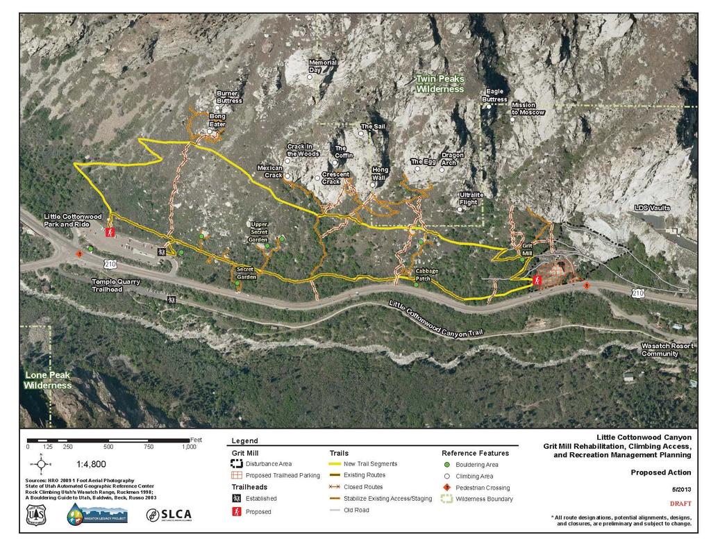
1 United States Department of Agriculture Forest Service Uinta-Wasatch-Cache National Forest Salt Lake Ranger District 6944 South 3000 East Salt Lake City, UT File Code: 1950/2300 Date: May 14, 2013 Dear Interested Parties: The Salt Lake Ranger District (SLRD), Uinta-Wasatch-Cache National Forest (UWCNF), is requesting your comments on the proposed Grit Mill and Climbing Master Plan Project. The proposed project is located on the north side of State Highway 210 in Little Cottonwood Canyon. It extends from the Little Cottonwood Canyon (LCC) Park and Ride lot to the Grit Mill site, and is bordered on the north by the Twin Peaks Wilderness. As the proposed projects would involve National Forest System resources, we will analyze and disclose these effects in accordance with the National Environmental Policy Act (NEPA) prior to deciding whether to approve them. We invite your comments regarding what environmental issues and concerns should be included in our NEPA analysis. PROPOSED ACTION The SLRD is proposing to implement a comprehensive plan to provide managed and sustainable access to climbing areas in Lower Cottonwood Canyon. The proposal includes three primary development components that are identified on the attached map. 1. Grit Mill removal & parking area development a. Demolish and remove the Grit Mill, all related out-structures, and industrial equipment, utilizing heavy equipment (track hoe/excavator). Remove debris to an appropriate offsite location. b. Construct a climbing access trailhead parking lot, including a restroom and interpretive site. The lot would be designed to accommodate approximately 35 vehicles and would be closed during the winter months. 2. Climbing Access Trail development a. Construct new trail segments Construct approximately 1.4 miles of new trail in areas without existing routes to provide sustainable access to climbing features and other existing access routes (see D below). The new trail segments, combined with the existing segments (see B below), would provide the core loop trail system and provide multi-use access to and from the Grit Mill and LCC Park and Ride trailheads. All core trail segments would become Forest Service system trails. b. Maintain existing core routes Upgrade approximately 0.7 miles of existing core routes to be consistent with Forest Service (FS) trail standards. These segments, combined with the new trail segments, discussed above, would complete the core system loop for access to and from climbing features and trailheads. Trail upgrades would include brushing and retreading to meet width and drainage standards. c. Close non-sustainable routes Close and rehabilitate approximately 0.9 miles of existing access routes that are not sustainable. These routes generally are very steep, run up and down the fall-line, are often redundant, and are highly erodible. Caring for the Land and Serving People Printed on Recycled Paper
2 d. Stabilize existing climbing access routes and belay platforms/landing pads Stabilize and maintain approximately 1.2 miles of short segments of existing routes to specific climbing features and landing pads to reduce resource impacts (erosion) to the core trail system and surrounding environment and provide sustainable access and climbing. Construct erosion control structures (water bars and check dams) and retaining walls in these areas. These routes provide access from the core trail system to specific climbing features and would not be included as FS system trails. 3. Roadside Parking Management - BACKGROUND a. Close all roadside parking between the Grit Mill and the LCC Park and Ride. The SLRD will coordinate with the Utah Dept. of Transportation (UDOT) and Unified Police Dept. (UPD) to develop a roadside parking signing and enforcement plan. The area surrounding the Grit Mill in lower LCC is an invaluable recreational resource on the Wasatch Front and has been actively used by climbers and other recreationists for over fifty years. Rock climbing has experienced a dramatic rise in popularity over the last twenty years; consequently, the user impacts on the rock climbing areas within LCC have also increased. Because no formal trail system has been established, climbers have created numerous random access routes/social trails. Many of these routes are steep, located in highly erodible areas, are unsustainable, and are often redundant. The access points to the numerous climbing and bouldering areas similarly have evolved and parking and access occur at areas on the highway that were not designed for that use and present safety issues. Numerous climbing areas are located in the Twin Peaks wilderness area and on private land owned by the Church of Jesus Crist of Latter Day Saints (LDS Church). The LDS Church has allowed climbers to park and climb on their property, though conflicts have occurred. The LDS Church has concerns regarding liability, security, and safety for its personnel and property at their storage vaults. The Grit Mill site, including the structures and abandoned equipment, have not been used for years and have recently become an unattractive nuisance as a site for graffiti and other negligent behavior. The site is currently closed to public use through a Forest Service Supervisor s Order. The disrepair and age of the facilities and equipment also pose a safety hazard for those who venture onto the site. The Grit Mill site is a predominant feature at the mouth of LCC and serves informally as the gateway to the canyon. The community has for years discussed numerous options for the site and establishment of the Wasatch Legacy Project has served as a catalyst to bring community members together to form a public/private partnership that has helped in the development of the Proposed Action discussed above. Community members include the Salt Lake Climbers Alliance, Salt Lake City, Salt Lake County, UDOT, UPD, Cottonwood Canyons Foundation (CCF), the LDS Church, Snowbird and Alta ski resorts, and local residents. The SLRD, and it partners are seizing the opportunity to mitigate the wide array of impacts to this valuable environment. The Proposed Action has been designed to improve sustainable recreation opportunities; provide for recreation, transportation and public safety; and to protect important resources including cultural, watershed, wildlife and vegetation. PURPOSE AND NEED The 2003 Revised Forest Plan for the Wasatch-Cache National Forest (Forest Plan) provides overarching direction, goals, standards and guidelines, and desired future conditions for all management activities on National Forest System lands. Watershed protection is a central theme for LCC and the Forest Plan recognizes the critical role in allowing a diverse range of high quality and sustainable recreation opportunities within the constraints of maintaining high quality watershed values. The Forest Plan also recognizes the challenges and the balancing of uses to protect the watershed in light of growing 2
3 populations and use. Consistent with growing use, the Forest Plan addresses the role of parking in managing capacity and supports the expansion of mass transit to address growth related transportation and parking issues. The purpose for this project is consistent with that direction and is to establish a managed system of trails, with appropriate parking, access, and restroom facilities, that facilitates sustainable climbing and other recreation opportunities for users, while minimizing impacts to the biological, physical, and social environments. The Proposed Action, consistent with this purpose, was designed to meet a number of needs, including; to provide improved access for climbers, maintain or improve scenic quality, preserve and interpret historical and cultural contexts, minimize impacts to adjacent private land owners, and address transportation issues and safety. Similarly, these needs must be met within the context of sustainable recreation and natural resource functions. PRELIMINARY ALTERNATIVES NEPA regulations require consideration of a "range of reasonable alternatives that would meet the proposal's purpose and need. As a minimum, this reasonable range must include the Proposed Action and a No Action Alternative. The No Action Alternative serves to establish baseline environmental conditions and provides a means to compare alternatives. Other alternatives may be identified as a result of the issues raised during the public comment period. Alternative 1: No Action - Under the No Action Alternative, none of the activities described under the Proposed Action would occur in the project area. The unmanaged uses in the Grit Mill and adjacent climbing areas would continue as they currently exist. No changes would occur to roadside parking or access points and routes. Alternative 2: The Proposed Action -Under the Proposed Action Alternative, the Grit Mill and climbing access routes and parking would be developed as described above. PRELIMINARY ISSUES The Forest Service Interdisciplinary Team identified the following preliminary issues to be addressed in the environmental analysis. These issues guide the formulation of alternatives and provide a framework for the effects analysis to be documented in the environmental analysis. Additional issues may be addressed in the analysis based on comments provided by the public and other entities. Preliminaries issues include effects on: Watershed and soil resources Recreation resources including unmanaged recreation use in the area and potential conflicts among users Cultural resources Transportation issues including access, parking, and traffic Wildlife, including winter range, and threatened, endangered, and sensitive species and their habitat Threatened, endangered, and sensitive plant species and noxious weeds Scenic quality Private land issues including public access, trespass, and property values DECISION TO BE MADE Cathy Kahlow, Salt Lake District Ranger of the UWCNF, is the Responsible Official for this project. Upon completion of the environmental analysis, she will decide whether and under what conditions to approve the Proposed Action or any alternative addressed in the EA. 3
4 PUBLIC INVOLVEMENT There will be several opportunities for public involvement in this NEPA process, starting with this scoping period. Scoping comments will be accepted for 30 days. Comments on this proposal must be received by the Salt Lake Ranger District by June 14, It is important that those interested in this Proposed Action participate at this time. To be most helpful, your comments should be as specific as possible and describe issues of concern. Written comments provide us a record of your concerns and will be used to identify significant issues and potentially to develop alternatives to be addressed in the environmental analysis. Electronic comments must be submitted in a format such as an message, rich text format (.rtf) or Word (.doc) to comments-intermtn-wasatch-cache-saltlake@fs.fed.us, or submit comments to: Cathy Kahlow District Ranger Salt Lake Ranger District 6944 South 3000 East Salt Lake City, UT At this point, on the basis of internal and interdisciplinary review, we anticipate that implementation of this proposal is not likely to result in significant environmental impacts, indicating that an Environmental Assessment (EA) is the appropriate level of analysis. If through scoping or our subsequent analysis we determine that significant impacts could occur, an Environmental Impact Statement may be prepared. ADDITIONAL INFORMATION This scoping notice and subsequent documentation of this NEPA process will be available on the Forest s website: For more information, please contact Cathy Kahlow, District Ranger, at or ckahlow@fs.fed.us, or Steve Scheid, Environmental Coordinator, at , or scheid@fs.fed.us. Thank you for your interest in the management of the UWCNF. Sincerely, /S/ Catherine H. Kahlow CATHERINE H. KAHLOW District Ranger Enclosures 4
5 5
Uinta-Wasatch-Cache National Forest Salt Lake Ranger District
 United States Department of Agriculture Forest Service Uinta-Wasatch-Cache National Forest Salt Lake Ranger District 6944 South 3000 East Salt Lake City, UT 84121 801-733-2660 File Code: 1950/2300 Date:
Decision Memo for Desolation Trail: Mill D to Desolation Lake Trail Relocation
 for Salt Lake County, Utah Uinta-Wasatch-Cache National Forest Salt Lake Ranger District 1. Background The present location of the Desolation Trail (#1159) between Mill D and Desolation Lake follows old
Proposed Action. Payette National Forest Over-Snow Grooming in Valley, Adams and Idaho Counties. United States Department of Agriculture
 United States Department of Agriculture Forest Service January 2012 Proposed Action Payette National Forest Over-Snow Grooming in Valley, Adams and Idaho Counties Payette National Forest Valley, Adams
Bradley Brook Relocation Project. Scoping Notice. Saco Ranger District. United States Department of Agriculture Forest Service
 Bradley Brook Relocation Project United States Department of Agriculture Forest Service Scoping Notice White Mountain National Forest February 2011 For Information Contact: Jenny Burnett White Mountain
Sawtooth National Forest Fairfield Ranger District
 United States Department of Agriculture Forest Service Sawtooth National Forest Fairfield Ranger District P.O. Box 189 Fairfield, ID. 83327 208-764-3202 Fax: 208-764-3211 File Code: 1950/7700 Date: December
White Mountain National Forest Saco Ranger District
 United States Department of Agriculture Forest Service White Mountain National Forest 33 Kancamagus Highway Conway, NH 03818 Comm: (603) 447-5448 TTY: (603) 447-3121 File Code: 1950 Date: February 26,
White Mountain National Forest Saco Ranger District
 United States Department of Agriculture Forest Service White Mountain National Forest Saco Ranger District 33 Kancamagus Highway Conway, NH 03818 Comm: (603) 447-5448 TTY: (603) 447-3121 File Code: 1950
Central Wasatch Visitor Use Study STEVEN W. BURR, PH.D. AND CHASE C. LAMBORN, M.S. INSTITUTE FOR OUTDOOR RECREATION AND TOURISM UTAH STATE UNIVERSITY
 Central Wasatch Visitor Use Study STEVEN W. BURR, PH.D. AND CHASE C. LAMBORN, M.S. INSTITUTE FOR OUTDOOR RECREATION AND TOURISM UTAH STATE UNIVERSITY Utah State University s Institute for Outdoor Recreation
Coronado National Forest Santa Catalina Ranger District
 United States Department of Agriculture Forest Service Coronado National Forest Santa Catalina Ranger District File Code: 1950 Date: October 14, 2015 Dear Interested Party: The Santa Catalina Ranger District
Kelly Motorized Trails Project Proposed Action
 Kelly Motorized Trails Project Proposed Action November 28, 2011 The Flagstaff Ranger District of the Coconino National Forest is seeking public input on the proposed Kelly Motorized Trails Project (formerly
Buffalo Pass Trails Project
 Buffalo Pass Trails Project Hahns Peak/Bears Ears Ranger District, Medicine Bow-Routt National Forests and Thunder Basin National Grassland Routt County, Colorado T6N 83W Sections 3-5, 8; T6N 84W Sections
Mt. Hood National Forest
 United States Department of Agriculture Forest Service Mt. Hood National Forest Zigzag Ranger District 70220 E. Highway 26 Zigzag, OR 97049 503-622-3191 Fax: 503-622-5622 File Code: 1950-1 Date: June 29,
DECISION MEMO. Rawhide Trail #7073 Maintenance and Reconstruction
 Page 1 of 6 Background DECISION MEMO USDA Forest Service Jefferson Ranger District Jefferson County, Montana Rawhide Trail #7073 is located in the Elkhorn Mountain Range approximately 10 miles east of
Williamson Rock/Pacific Crest National Scenic Trail (PCT) Project EIS. Notice of intent to prepare an Environmental Impact Statement.
 Project EIS. Notice of intent to prepare an Environmental Impact Statement.") [3411-15-P] DEPARTMENT OF AGRICULTURE Forest Service Angeles National Forest; Los Angeles County, CA Williamson Rock/Pacific Crest National Scenic Trail (PCT) Project EIS AGENCY: ACTION: Forest Service,
[3411-15-P] DEPARTMENT OF AGRICULTURE Forest Service Angeles National Forest; Los Angeles County, CA Williamson Rock/Pacific Crest National Scenic Trail (PCT) Project EIS AGENCY: ACTION: Forest Service,
Daisy Dean Trail 628/619 ATV Trail Construction
 Background and Purpose and Need The Daisy Dean ATV Trail Construction Project is located in the Little Belt Mountains, Musselshell Ranger District, Lewis and Clark National Forest approximately 32 miles
MONTEREY REGIONAL AIRPORT MASTER PLAN TOPICAL QUESTIONS FROM THE PLANNING ADVISORY COMMITTEE AND TOPICAL RESPONSES
 MONTEREY REGIONAL AIRPORT MASTER PLAN TOPICAL QUESTIONS FROM THE PLANNING ADVISORY COMMITTEE AND TOPICAL RESPONSES Recurring topics emerged in some of the comments and questions raised by members of the
1803 West Hwy 160 Monte Vista, CO (719) TTY (719)
 TTY (719)") USDA Forest Service Rio Grande National Forest http://www.fs.fed.us/r2/riogrande 1803 West Hwy 160 Monte Vista, CO 81144 (719)852-5941 TTY (719)852-6271 USDI Bureau of Land Management San Luis Valley Center
USDA Forest Service Rio Grande National Forest http://www.fs.fed.us/r2/riogrande 1803 West Hwy 160 Monte Vista, CO 81144 (719)852-5941 TTY (719)852-6271 USDI Bureau of Land Management San Luis Valley Center
ROAD AND TRAIL PROJECT APPROVAL
 ROAD AND TRAIL PROJECT APPROVAL www.marincountyparks.org Marin County Parks, 3501 Civic Center Dr, Suite 260, San Rafael, CA 94903 DATE: July 12, 2017 PRESERVE: Gary Giacomini Open Space Preserve PROJECT:
FINAL TESTIMONY 1 COMMITTEE ON RESOURCES UNITED STATES HOUSE OF REPRESENTATIVES. July 13, 2005 CONCERNING. Motorized Recreational Use of Federal Lands
 FINAL TESTIMONY 1 STATEMENT OF DALE BOSWORTH CHIEF Of the FOREST SERVICE UNITED STATES DEPARTMENT OF AGRICULTURE Before the SUBCOMMITTEE ON FORESTS AND FOREST HEALTH And the SUBCOMMITTEE ON NATIONAL PARKS,
Francis Marion and Sumter National Forests
 United States Department of Agriculture Forest Service Francis Marion and Sumter National Forests 2967 Steed Creek Rd. Huger, SC 29450 Tele: (843)336-2200 File Code: 1950 Date: February 13, 2015 To Whom
David Johnson. Tom, Attached please find the final scoping letter and figures for your review. David
 David Johnson From: Sent: To: Cc: Subject: Attachments: David Johnson Tuesday, April 12, 2011 4:33 PM Thomas Malecek Dave Dyer; Jason Marks (jmarks@segroup.com) VWC Scoping Letter
System Group Meeting #1. March 2014
 System Group Meeting #1 March 2014 Meeting #1 Outcomes 1. Understand Your Role 2. List of Revisions to Existing Conditions 3. Information Sources Study Area The Purpose of Mountain Accord is to Preserve
Decision Memo Sun Valley Super Enduro & Cross-Country Mountain Bike Race. Recreation Event
 Decision Memo 2015 Sun Valley Super Enduro & Cross-Country Mountain Bike Race Recreation Event USDA Forest Service Ketchum Ranger District, Sawtooth National Forest Blaine County, Idaho Background The
BACKGROUND DECISION. Decision Memo Page 1 of 6
 DECISION MEMO DEVIL S ELBOW BY-PASS, BOUNDARY TRAIL NO.1 U.S. FOREST SERVICE T9N, R7E, SECTION 9 RANGE 5E COWLITZ COUNTY WA MOUNT ST. HELENS NATIONAL VOLCANIC MONUMENT, GIFFORD PINCHOT NATIONAL FOREST
White Mountain National Forest. Rumney Rocks Project Supplemental Environmental Assessment. 30-day Comment Report
 White Mountain National Forest United States Department of Agriculture Forest Service Rumney Rocks Project Supplemental Environmental Assessment Eastern Region Town of Rumney, Grafton County, NH 30-day
Thank you for the opportunity to comment on the proposed action to add trails and trailheads to the Red Rock District trail system.
 July 14, 2010 Jennifer Burns Red Rock Ranger District PO Box 20429 Sedona, AZ 86341 Flagstaff Biking Organization PO Box 23851 Flagstaff, AZ 86002 Dear Jennifer- Thank you for the opportunity to comment
Tahoe National Forest Over-Snow Vehicle Use Designation
 Tahoe National Forest Over-Snow Vehicle Use Designation USDA Forest Service Tahoe National Forest February 20, 2015 Introduction The Forest Service, U.S. Department of Agriculture will prepare an Environmental
BACKCOUNTRY PROGRAM WATERSHED REPORT 2002
 BACKCOUNTRY PROGRAM WATERSHED REPORT 2002 Pfeifferhorn Peak, Lone Peak Wilderness Area Salt Lake Ranger District, Wasatch Cache National Forest Prepared by Backcountry Rangers: Joelle Dickson, Greg Hilbig
Logo Department Name Agency Organization Organization Address Information 5700 North Sabino Canyon Road
 Logo Department Name Agency Organization Organization Address Information United States Forest Coronado National Forest 5700 North Sabino Canyon Road Department of Service Santa Catalina Ranger District
City of Durango 5.8 FUNDING TRAILS DEVELOPMENT
 5.8 FUNDING TRAILS DEVELOPMENT The City has been successful in establishing dedicated local funding sources as well as applying for grants to develop the City s trail system, having received nearly $2.4
Chatsworth Branch Library Devonshire Street, Chatsworth, CA Thursday, November 16, :00-8:00 pm
 Chatsworth Branch Library 21052 Devonshire Street, Chatsworth, CA 91311 Thursday, November 16, 2017 6:00-8:00 pm Project Team County of Los Angeles Department of Parks and Recreation Kathline King Chief
Welcome to the future of Terwillegar Park a Unique Natural Park
 Welcome to the future of Terwillegar Park a Unique Natural Park 1 Introduction The Terwillegar Park Concept Plan study will develop an overall concept plan, management objectives and development guidelines
To: Cam Hooley From: Trails 2000 Date: September 30, 2016 Re: Hermosa Comments. Dear Cam:
 ! To: Cam Hooley From: Trails 2000 Date: September 30, 2016 Re: Hermosa Comments Dear Cam: Trails 2000 is commenting on the Forest Service Management Plan for the Hermosa Creek Watershed Management Plan
USDA Forest Service Deschutes National Forest DECISION MEMO. Round Lake Christian Camp Master Plan for Reconstruction and New Facilities
 USDA Forest Service Deschutes National Forest DECISION MEMO Round Lake Christian Camp Master Plan for Reconstruction and New Facilities Jefferson County, Oregon T. 13 S., R. 8 E., Section 16, W.M. Background:
Stevenson Ranch Library The Old Road, Stevenson Ranch, CA Thursday, November 9, :00-8:00 pm
 Stevenson Ranch Library 25950 The Old Road, Stevenson Ranch, CA 91381 Thursday, November 9, 2017 6:00-8:00 pm Project Team County of Los Angeles Department of Parks and Recreation Kathline King Chief of
RUSHMORE CONNECTOR TRAIL PROPOSAL
 PURPOSE AND NEED Background The U.S. Forest Service, Black Hills National Forest (Forest Service) has received a special use permit application from the State of South Dakota Department of Game, Fish and
National Forests and Grasslands in Texas
 United States Department of Agriculture Forest Service National Forests and Grasslands in Texas Sam Houston NF 394 FM 1375 West New Waverly, Texas 77358 Phone 936-344-6205 Dear Friends, File Code: 1950
Decision Memo Ice Age Trail Improvement (CRAC 37)
") Decision Memo Ice Age Trail Improvement (CRAC 37) U.S. Forest Service Chequamegon-Nicolet National Forest, Medford-Park Falls Ranger District Taylor County, Wisconsin T32N, R2W, Town of Grover, Section
Decision Memo Ice Age Trail Improvement (CRAC 37) U.S. Forest Service Chequamegon-Nicolet National Forest, Medford-Park Falls Ranger District Taylor County, Wisconsin T32N, R2W, Town of Grover, Section
Theme: Predominately natural/natural appearing; rustic improvements to protect resources. Size*: 2,500 + acres Infrastructure**:
 Recreation Opportunity Spectrum (ROS) Classes The Recreation Opportunity Spectrum (ROS) provides a way to describe the variations in the degree of isolation from the sounds and influences of people, and
DECISION MEMO. for Single-Track Mountain Bike Trail Snowbird Ski and Summer Resort
 DECISION MEMO for Single-Track Mountain Bike Trail Snowbird Ski and Summer Resort Salt Lake County, Utah Uinta-Wasatch-Cache National Forest Salt Lake Ranger District DECISION AND RATIONALE I have reviewed
Proposed Action Kaibab Campground Capital Improvement Project September 2008
 Background Kaibab Campground Capital Improvement Project September 2008 The Williams Ranger District of the Kaibab National Forest is proposing to improve the Kaibab Lake Campground. Kaibab Lake Campground
RE: Access Fund Comments on Yosemite National Park Wilderness Stewardship Plan, Preliminary Ideas and Concepts
 September 30, 2016 Superintendent Yosemite National Park Attn: Wilderness Stewardship Plan P.O. Box 577 Yosemite, CA 95389 RE: Access Fund Comments on Yosemite National Park Wilderness Stewardship Plan,
RIM TRAIL EXTENSION PROJECT
 DECISION MEMO For RAINBOW RIM TRAIL EXTENSION PROJECT Located on National Forest System Lands USDA Forest Service, Southwest Region Kaibab National Forest - North Kaibab Ranger District T.35 N, R.1 E,
Beaverhead-Deerlodge National Forest Butte Ranger District
 United States Department of Agriculture Forest Service Beaverhead-Deerlodge National Forest 1820 Meadowlark Lane Butte, MT 59701 406 494-2147 File Code: 1950 Date: September 1, 2010 Dear Interested Party:
Response to Public Comments
 Appendix D Response to Public Comments Comment Letter # Response 1, 2, 3, 4, 5, 7, 8, 9, 10, 11, 12, 13, 14, 15, 16, 17, 18, 19, 20, 22, 23, 24, 25, 26, 27, 29, 30, 31, 32, 33, 34, 35, 36, 37, 38, 39,
Longmont to Boulder Regional Trail Jay Road Connection DRAFT FINAL REPORT
 Longmont to Boulder Regional Trail Jay Road Connection DRAFT FINAL REPORT December 2018 Project Summary Boulder County, Colorado, in partnership with the City of Boulder, is evaluating options for multi-use
CHAPTER III: TRAIL DESIGN STANDARDS, SPECIFICATIONS & PERMITS
 CHAPTER III Trail Design Standards, Specifications & Permits This chapter discusses trail standards, preferred surface types for different activities, permits, and other requirements one must consider
Fossil Creek Wild & Scenic River Comprehensive River Management Plan Forest Service Proposed Action - details March 28, 2011
 Fossil Creek Wild & Scenic River Comprehensive River Management Plan Forest Service Proposed Action - details March 28, 2011 Primary Goals of the Proposed Action 1. Maintain or enhance ORVs primarily by
The Vision for the San Juan Islands Scenic Byway
 The Vision for the San Juan Islands Scenic Byway 2 Judd Cove, Orcas Island, Courtesy of Kurt Thorson (kurtthorson.com) and San Juan County Land Bank Vision for the San Juan Islands Scenic Byway The San
Tracy Ridge Shared Use Trails and Plan Amendment Project
 Tracy Ridge Shared Use Trails and Plan Amendment Project Scoping Document Forest Service Allegheny National Forest Bradford Ranger District McKean, County, Pennsylvania In accordance with Federal civil
Thank you for this third opportunity to comment on the proposed revisions to the Coconino National Forest Management plan.
 March 19, 2014 Flagstaff Biking Organization PO Box 23851 Flagstaff, AZ 86002 Vern Keller Coconino National Forest Attn: Plan Revision 1824 South Thompson Street Flagstaff, Arizona 86001 coconino_national_forest_plan_revision_team@fs.fed.us
Decision Memo Broken Wheel Ranch Equestrian Outfitter Special-Use Permit Proposed Action
 Decision Memo Broken Wheel Ranch Equestrian Outfitter Special-Use Permit USDA Forest Service Mississippi Bluffs Ranger District, Shawnee National Forest Jackson and Union Counties, Illinois Proposed Action
Thank you for this second opportunity to comment on the proposed revisions to the Coconino National Forest Management plan.
 March 8, 2011 Flagstaff Biking Organization PO Box 23851 Flagstaff, AZ 86002 Yewah Lau Coconino National Forest Attn: Plan Revision 1824 South Thompson Street Flagstaff, Arizona 86001 Sent via electronic
Preferred Recreation Recommendations Stemilt-Squilchuck Recreation Plan March 2018
 Preferred Recreation Recommendations Stemilt-Squilchuck Recreation Plan March 2018 Below are the recommended recreation ideas and strategies that package together the various recreation concepts compiled
Appendix C. Tenderfoot Mountain Trail System. Road and Trail Rehabilitation Plan
 Appendix C Tenderfoot Mountain Trail System Road and Trail Rehabilitation Plan All rehabilitation work would be under the direction of the District Fisheries Biologist, the Forest Hydrologist, and/or the
Proposal to Redevelop Lower Kananaskis River-Barrier Lake. Bow Valley Provincial Park. Frequently Asked Questions
 Proposal to Redevelop Lower Kananaskis River-Barrier Lake Bow Valley Provincial Park Frequently Asked Questions What is being proposed? What are the details of the proposal? Where is the project area located?
MUNICIPALITY OF ANCHORAGE
 MUNICIPALITY OF ANCHORAGE ANCHORAGE PARKS & RECREATION Memorandum PRC 08-56 DATE: 5 August 2008 TO: FROM: SUBJECT: Parks & Recreation Commission Holly Spoth-Torres, Park Planner PRC 08-56 Far North Bicentennial
White Mountain National Forest. Pond of Safety Accessible Trail & Shoreline Access Project. Scoping Report. Township of Randolph Coos County, NH
 White Mountain National Forest United States Department of Agriculture Forest Service Eastern Region Pond of Safety Accessible Trail & Shoreline Access Project Township of Randolph Coos County, NH Scoping
DRAFT. Dorabelle Campground Rehabilitation
 DRAFT Dorabelle Campground Rehabilitation September 2012 1.1 REGIONAL SETTING AND PROJECT LOCATION The Dorabelle Campground is located on the western shore of Shaver Lake in Fresno County, California (Section
DECISION MEMO North Zone (Legacy Trails) Trail Stabilization Project
 Trail Stabilization Project") DECISION MEMO North Zone (Legacy Trails) Trail Stabilization Project USDA FOREST SERVICE Rocky Mountain Region (R2) Shoshone National Forest Wapiti and Greybull Ranger District Park County, Wyoming Background
DECISION MEMO North Zone (Legacy Trails) Trail Stabilization Project USDA FOREST SERVICE Rocky Mountain Region (R2) Shoshone National Forest Wapiti and Greybull Ranger District Park County, Wyoming Background
Section 1 Introduction
 BST Coalition Annual Report 2014 Section 1 Introduction The Bonneville Shoreline Trail has been designated as Utah's Millennium Legacy Trail, as part of a White House initiative on the basis of our Governor's
SOUTH INTERCHANGE AREA
 Santaquin City General Plan 1 Location and Characteristics The South Interchange Area of Santaquin is located west of Interstate 15 and south of 500 South (Figure 1). It includes properties already annexed
Chetco River Kayaking Permit
 Decision Memo USDA Forest Service Rogue River-Siskiyou National Forest Gold Beach Ranger District - Curry County, Oregon Wild Rivers Ranger District Josephine County, Oregon BACKGROUND A special use permit
LEAVE NO TRACE CENTER FOR OUTDOOR ETHICS CONSULTING SERVICES
 LEAVE NO TRACE CENTER FOR OUTDOOR ETHICS CONSULTING SERVICES LEAVE NO TRACE PURPOSE Americans love the outdoors. Today, more than 300 million people visit America s national parks and another 150 million
Final Environmental Impact Statement for the Merced Wild and Scenic River. Comprehensive Management Plan, Yosemite National Park, Madera and Mariposa
 This document is scheduled to be published in the Federal Register on 02/26/2014 and available online at http://federalregister.gov/a/2014-04061, and on FDsys.gov DEPARTMENT OF THE INTERIOR 4312-FF NATIONAL
Appendix F Public authorities responses
 Planning Proposal under sec 55 of the EP&A Act LEP Refinements Appendix F Public authorities responses Appendix F Public authorities responses Prior to public exhibition, consultation was made with the
Decision Notice and Finding of No Significant Impact
 Decision Notice and Finding of No Significant Impact Steamboat Ski Area Summer Trails Project USDA Forest Service Medicine Bow-Routt National Forests Hahns Peak/Bears Ears Ranger District Routt County,
1.0 PURPOSE AND NEED
 1.0 Purpose and Need 1.0 PURPOSE AND NEED 1.1 INTRODUCTION This Environmental Assessment (EA) describes the environmental effects of the USDA Forest Service (USFS) proposal to improve recreation opportunities
Creating a User-Driven Long-Distance OHV Trail Through Partnering
 Joseph Raffaele Outdoor Recreation Planner U.S. Bureau of Land Management Yuma, Arizona Creating a User-Driven Long-Distance OHV Trail Through Partnering BLM is a multiple-use land management agency within
BACKCOUNTRY TRAIL FLOOD REHABILITATION PROGRAM
 BACKCOUNTRY TRAIL FLOOD REHABILITATION PROGRAM Backcountry Trail Flood Rehabilitation A June 2013 Flood Recovery Program Summary In June 2013, parts of Southern Alberta were devastated from significant
Connie Rudd Superintendent, Black Canyon of the Gunnison National Park
 National Park Service U.S. Department of the Interior Black Canyon of the Gunnison National Park and Curecanti National Recreation Area Information Brochure #1 Wilderness and Backcountry Management Plan
Lakes Landscape Travel Management
 Decision Notice & Finding of No Significant Impact Lakes Landscape Travel Management USDA Forest Service Columbine Ranger District, San Juan National Forest Archuleta, Hinsdale, and La Plata Counties,
Business Item No XXX. Proposed Action That the Metropolitan Council approve the Coon Creek Regional Trail Master Plan.
 Business Item No. 2015-XXX Metropolitan Parks and Open Space Commission Meeting date: July 7, 2015 For the Community Development Committee meeting of July 20, 2015 For the Metropolitan Council meeting
EXECUTIVE SUMMARY PROGRAM DEVELOPMENT REPORT PURPOSE EXISTING SETTING EXPANDING PARKLAND
 EXECUTIVE SUMMARY PROGRAM DEVELOPMENT REPORT PURPOSE As the culmination of the first phase of the master planning process, this Program Development Report creates the framework to develop the Calero County
Chapter 6: POLICY AND PROCEDURE RECOMMENDATIONS
 Chapter 6 POLICY AND PROCEDURE RECOMMENDATIONS FOR SRRA Below are seven policy elements that should be considered for adoption by the Southwest Regional Recreation Authority of Virginia: 1. Develop strategies
Opportunities for Solitude in Salt Lake Ranger District Wilderness Areas; Uinta-Wasatch-Cache National Forest
 Opportunities for Solitude in Salt Lake Ranger District Wilderness Areas; Uinta-Wasatch-Cache National Forest Prepared by: Henry Lilly (graduate research assistant) Jeff Rose (co-investigator) Matthew
Ouimet Canyon Provincial Nature Reserve. Management Plan
 Ouimet Canyon Provincial Nature Reserve Management Plan NOTE: This document has been scanned and formatted, and therefore is slightly different from the original version. -March 2002 Additional copies
White Mountain National Forest
 White Mountain National Forest United States Department of Agriculture Forest Service Eastern Region Boles Brook Snowmobile Bridge Decision Memo Boles Brook Snowmobile Bridge Project Town of Woodstock
CHAPTER 5. Chapter 5 Recreation Element
 CHAPTER 5 Recreation Element Chapter 5 Recreation Element The Recreation Element of the Meyers Area Plan is a supplement to the Recreation Element of the TRPA Regional Plan and the El Dorado County General
Flow Stand Up Paddle Board Parkway Plan Analysis
 Regional Parks Department Jeffrey R. Leatherman, Director County of Sacramento Divisions Administration Golf Leisure Services Maintenance Rangers Therapeutic Recreation Services Flow Stand Up Paddle Board
Kit Carson-Challenger Ridge Trail Project Annual Performance Report-2014 October 22, 2014
 1 Kit Carson-Challenger Ridge Trail Project Annual Performance Report-2014 October 22, 2014 Willow Lake and Kit Carson Peak 2 SUMMARY The Rocky Mountain Field Institute began Phase 1 of a multi-phase,
Silver Creek Plunge Campground Reconstruction
 Silver Creek Plunge Campground Reconstruction PROPOSED ACTION REPORT Emmett Ranger District Boise National Forest 1805 Highway 16, Room 5 Emmett, Idaho 83617 November 2009 Silver Creek Plunge Campground
BST Coalition Annual Report 2005
 BST Coalition Annual Report 2005 I. Introduction The Bonneville Shoreline Trail Coalition (Coalition) is an organization of entities, both citizen and governmental, representing the communities in Utah
This document is being shared by the Parks, Recreation and Musuem Advisory Board at the request of Golden citizens and in order to be transparent
 This document is being shared by the Parks, Recreation and Musuem Advisory Board at the request of Golden citizens and in order to be transparent about what documents and information was shared during
Alternative 3 Prohibit Road Construction, Reconstruction, and Timber Harvest Except for Stewardship Purposes B Within Inventoried Roadless Areas
 Roadless Area Conservation FEIS Summary Table S-1. Comparison of Key Characteristics and Effects by Prohibition Alternative. The effects summarized in this table A would occur in inventoried roadless areas
Trails Technical Committee
 Trails Technical Committee Winter 2017 Draft Report Alignment Proposals for the Inyo National Forest and the Town of Mammoth Lakes Map ID #S18 February 08, 2017 Map ID #S18 Key Agreements As of February
National Forests in North Carolina Pisgah National Forest Appalachian Ranger District Burnsville Station
 United States Department of Agriculture Forest Service National Forests in North Carolina Pisgah National Forest Appalachian Ranger District Burnsville Station PO Box 128 US Bypass 19 Burnsville, NC 28714-0128
Understanding user expectations And planning for long term sustainability 1
 Understanding user expectations And planning for long term sustainability 1 What is a natural surface trail? It can be as simple has a mineral soil, mulched or graveled pathway, or as developed as elevated
UTA Ski Service Redesign. Christopher Chesnut Sr. Manager of Integrated Service Planning Utah Transit Authority Salt Lake City, UT
 UTA Ski Service Redesign Christopher Chesnut Sr. Manager of Integrated Service Planning Utah Transit Authority Salt Lake City, UT Stephanie McVey Regional Planning & Environmental Manager WSP USA Tempe,
Hiawatha National Forest St. Ignace Ranger District. File Code: 1950 Date: August 5, 2011
 United States Department of Agriculture Forest Service Hiawatha National Forest St. Ignace Ranger District W1900 West US-2 St. Ignace, MI 49781 906-643-7900 File Code: 1950 Date: August 5, 2011 Dear National
January 14, Orange County Transportation Authority Attn: M2 NCCP/HCP 550 South Main Street P.O. Box Orange, CA
 Equestrian Trails, Inc. Corral 357 P.O. Box 1026 Trabuco Canyon, CA 92678 http://saddlebackcanyonriders.com/ President: James Iacono... 714-612-1789 January 14, 2016 Orange County Transportation Authority
The Chu property is a 6.57 acre parcel located in the Town of Superior on the west side of McCaslin Boulevard. In 2014, the Town of Superior acquired
 1 The Chu property is a 6.57 acre parcel located in the Town of Superior on the west side of McCaslin Boulevard. In 2014, the Town of Superior acquired the Chu property for open space with a contribution
Lolo National Forest Plan Amendment #38
 Lolo National Forest Plan Amendment #38 Welcome Creek Wilderness Opportunity Classes and Standards USDA Forest Service, Lolo National Forest Missoula Ranger District Granite County, Montana July 2012 I.
Non-motorized Trail Plan & Proposal. August 8, 2014
 Town of Star Valley Ranch, Wyoming and the Star Valley Ranch Association in partnership with the USDA Forest Service, Bridger-Teton National Forest, Greys River Ranger District Non-motorized Trail Plan
Table of Contents. page 3 Long term Goals Project Scope Project History. 4 User Groups Defined Trail Representative Committee. 5 Trail Users Breakdown
 Launched April 27th, 2010 1 Table of Contents page 3 Long term Goals Project Scope Project History 4 User Groups Defined Trail Representative Committee 5 Trail Users Breakdown 13 Trail Users Desires 16
Bear Creek Habitat Improvement Project
 06/10/10 Bear Creek Habitat Improvement Project El Paso County, Colorado Pike National Forest and Colorado Springs Utilities Owned Land Report prepared by: Eric Billmeyer Executive Director Rocky Mountain
Buford / New Castle Motorized Trail
 Buford / New Castle Motorized Trail Rifle Ranger District, White River National Forest Garfield County, Colorado Comments Welcome The Rifle Ranger District of the White River National Forest welcomes your
Decision Memo for Philmont Scout Ranch Bike Trail and Access Reroute Project
 Decision Memo Philmont Scout Ranch Bike Trail and Access Reroute Project USDA Forest Service, Southwestern Region Questa Ranger District, Carson National Forest Colfax County, New Mexico (T. 30N, R. 17E,
April 10, Mark Stiles San Juan Public Lands Center Manager 15 Burnett Court Durango, CO Dear Mark,
 Mark Stiles San Juan Public Lands Center Manager 15 Burnett Court Durango, CO 81301 Dear Mark, We are pleased to offer the following comments on the draft San Juan Public Lands Center management plans
Fremont Point Cabin Reconstruction and Expansion Project Project Proposal & Public Scoping Documentation
 Fremont Point Cabin Reconstruction and Expansion Project Fremont-Winema National Forests Silver Lake Ranger District The Silver Lake Ranger District of the Fremont-Winema National Forests is proposing