2011 Nags Head Beach Nourishment Project Update. Tim Kana & Haiqing Kaczkowski
|
|
|
- Christian Little
- 5 years ago
- Views:
Transcription


1 2011 Nags Head Beach Nourishment Project Update Tim Kana & Haiqing Kaczkowski NCBIWA Conference 3 April 2017

2 Outline of the Presentation 1 Review 2011 Nourishment Project Post-project monitoring efforts 2 Project Performance Condition and 5 Year Summary Volume analysis methodology Monitoring results 3 Post-Hurricane Results 2016 Storm Losses Summary of Storm Processes
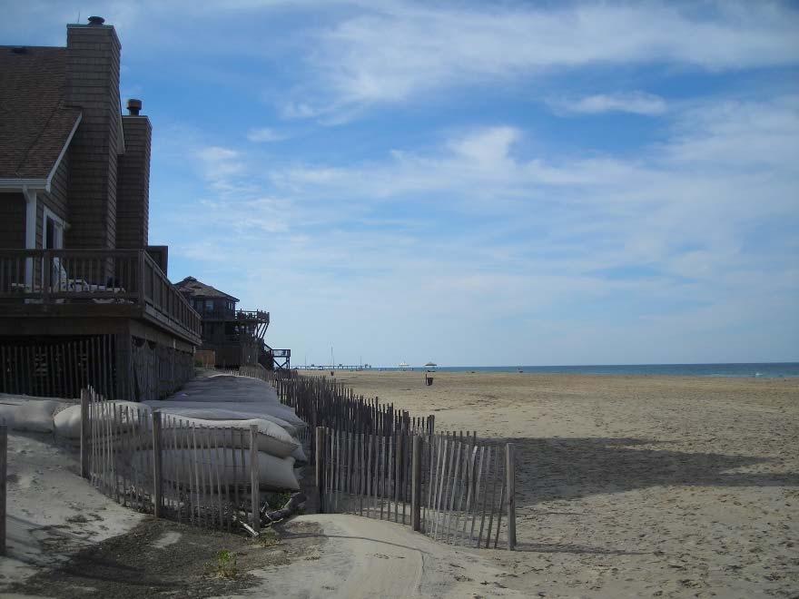
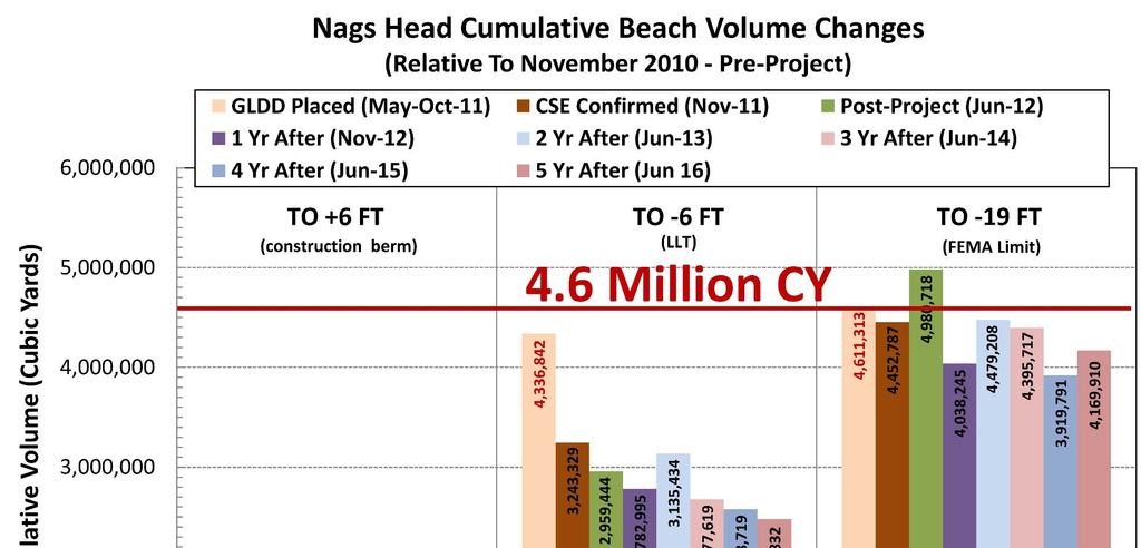
3 Part 1 Review of the 2011 Nourishment The largest locally funded beach nourishment accomplished to date in the United States. 4.6 million cubic yards Along 10 miles Over 100 borings to confirm high quality offshore sand source Construction cost of $30.8 million Unit Price $6.70 per cy 5 months for summer construction between 24 May and 27 Oct 2011
 Compaction tests for 3 years Semi-annual condition surveys")

4 Part 1 Review of the Post-Project Monitoring Required by state and federal permits Prerequisite for FEMA s post-storm beach restoration funding Scope of Work (2012 thru 2016) Compaction tests for 3 years Semi-annual condition surveys in Year 1 Annual condition surveys in Years 2-5 Sediment sampling in Years 2 & 4 Aerial orthophotos in Year 3 Annual oblique aerial & ground photos Annual monitoring reports Biological studies & reports in Years 1 & 2* (*Conducted by CZR)

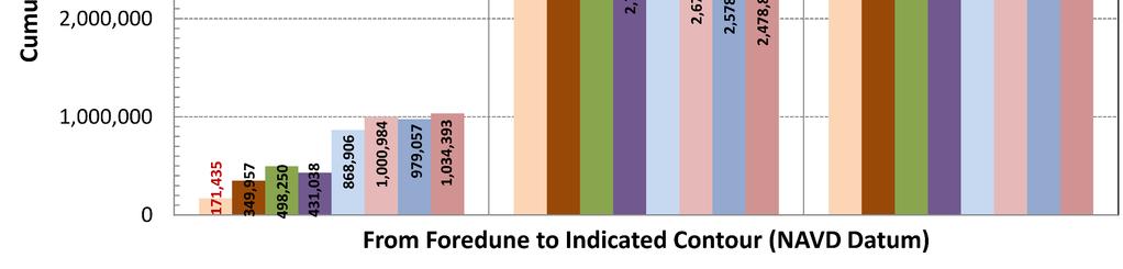
5 Part 2 Project Performance Methodology Beach Condition Analysis The Littoral Sand Box Lens 1 Foredune From the ~crest of dune to +6 ft NAVD* Lens 2 Beach Between +6 ft and -6 ft NAVD Lens 3 Underwater Between -6 ft and -19 ft NAVD *NAVD-North American Vertical Datum of 1988 = ~mean sea level

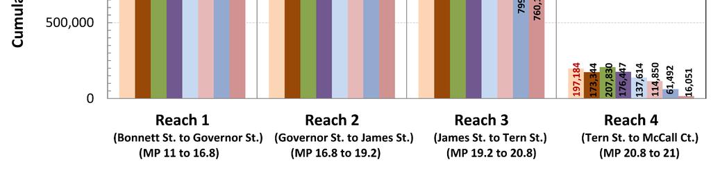
6 Project Reaches and Subreaches Reach 1 MP 11 to to Reach 2 MP 16.8 to 19.2 R to Reach 3 MP 19.2 to to o R3N to R2 R3 Dune o R3S to Reach 4 MP 20.8 to to
 Seagull Dr.")

7 Reach 3 (Subreach 3S) & 4 (Project Taper) Seagull Dr. South most one mile of Nags Head Erodes ~4 Times Faster Than 90% of Nags Head
8 Part 2 Project Performance Results Results include: Sand volumes along Nags Head Volumes by reach and subreach Dune growth along Nags Head Results compared to: Pre-nourishment condition (2016 vs. 2010) Previous years (eg vs. 2015) Historical analysis
9 Results Sand Volumes by Station along Nags Head


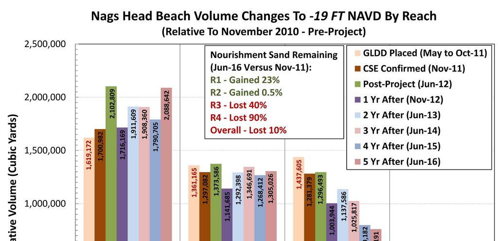
10 Results* Total Volume by Reach and Subreach *Before Hurricane Matthew
11 Results Compared to Historical Analyses First data set in 1994 Lack of historical data Estimated annual erosion rate by the USACE*: 900,000 cy/yr Adopted annual erosion rate by CSE**: 275,000 cy/yr Actual annual erosion rates since project completion have varied Max erosion rate: ~500,000 cy/yr (2012 to 2013) Max accretion rate: ~250,000 cy/yr ( ) Average change erosion at 100,000 cy/yr (before 2016 Storms!) *USACE Final feasibility report and environmental impact statement: Dare County beaches. ** CSE 2005 & Preliminary and Final design reports for beach nourishment at Nags Head.

12 Results Dune Growth along Nags Head
13 Results Dune Behavior Before/After Nourishment Above +6 ft NAVD


 Dec 2003 April")
 Nov")
14 Review of a Previous Dune Construction Project at Nags Head After Hurricane Isabel (18 September 2003) Dec 2003 April 2004 Post-Isabel Dune Building (FEMA) Nov 2010 May 2004
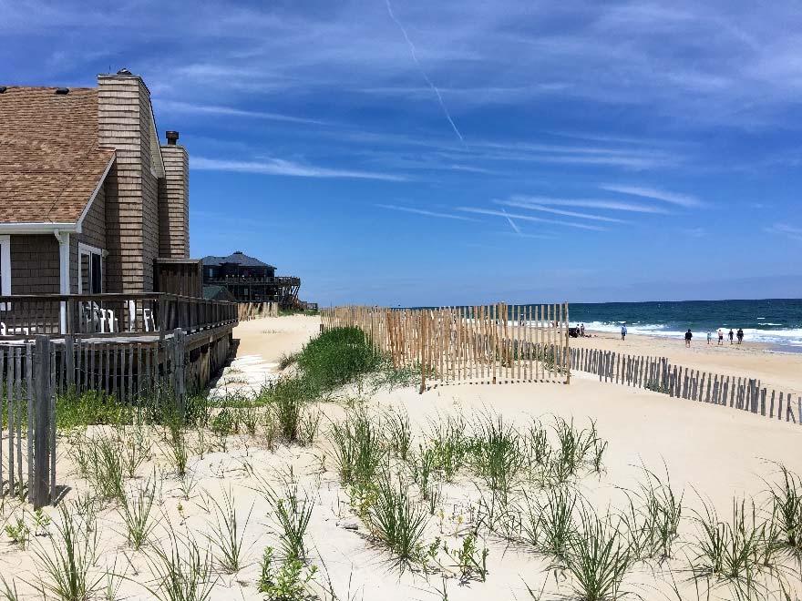

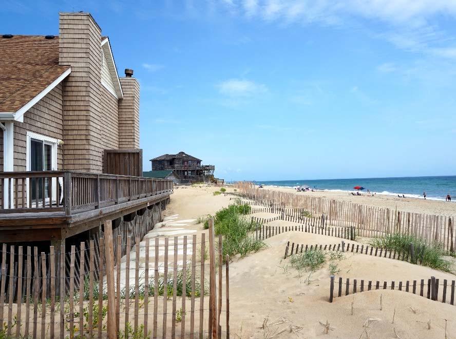
15 Nags Head Post-Nourishment Dune Growth Jun 2012 Jun 2014 Jun 2016 Jun 2015
16
17
18 Nags Head Average* Profile Evolution Higher & Wider Foredune Greater Underwater Volume Similar Dry Beach Width *n=104

19 Results Beach Width by 1-Mile Average


20 Pre Post Matthew October 2016 Reach 1 Nags Head Pier Post-Storm Images: Courtesy NOAA-USGS


21 Pre Post Matthew October 2016 Reach 4 McCall Court- National Seashore 7 Jun Oct 2016 Post-Storm Images: Courtesy NOAA-USGS
22 Post storm Condition Foredune Net Losses in the Foredune & Visible Beach Were Minor Dune & Visible Beach
23 Dune, Visible Beach & Underwater
24
25 Winds, Waves & Tides At Duck USACE FRF Hurricane Matthew Wind Shift East to North Then Prolonged North Winds Data: Courtesy USACE - FRF
26 5 Year Summary 2011 to 2016 Overall lost 10% of nourishment sand Before Hermine & Matthew North ~5.8 miles gained ~300,000 cy Middle to south ~2.4 miles were stable South ~1.8 miles lost~680,000 cy Average Annual Loss ~100,000 cy/yr 2016 Post-storm Condition: Overall lost 30% of nourishment sand R1 R4 lost 22, 29, 37 and 46 cy/ft, respectively Nourishment Volume Remaining = ~61% Average Annual Loss ~360,000* cy/yr (Nov 11-Nov 16) vs Design = ~275,000 cy/yr Conclusion: The nourished beach is performing like a natural beach along Nags Head and average annual losses are expected to be below design after the next monitoring period.
Edisto Beach Renourishment and Groin Lengthening Project. Tim Kana Coastal Science & Engineering
 Edisto Beach Renourishment and Groin Lengthening Project Tim Kana Coastal Science & Engineering Hurricane Matthew 8 Oct 2016 Cat 1 Storm @ Edisto Beach Worst Surge Event Since DAVID in 1979 Tides ~ 5 ft
DAMAGE ASSESSMENT OF SAND FENCING GARDEN CITY, NORTH LITCHFIELD AND LITCHFIELD BEACH GEORGETOWN COUNTY, SC
 OF SAND FENCING GARDEN CITY, NORTH LITCHFIELD AND LITCHFIELD BEACH GEORGETOWN COUNTY, SC June 07, 2017 PREPARED FOR: GEORGETOWN COUNTY DEPARTMENT OF PUBLIC SERVICES PREPARED BY: The EARTHWORKS Group 11655
St. Augustine Port, Waterway & Beach District. St. Augustine Inlet 2013 draft Inlet Management Plan. March 19, 2013
 Division of Water Resource Management St. Augustine Port, Waterway & Beach District St. Augustine Inlet 2013 draft Inlet Management Plan March 19, 2013 Discussion Outline Florida Statutes Florida Inlets
PORT EVERGLADES SAND BYPASS PROJECT
 28 th Annual National Conference on Beach Preservation Technology February 4, 2015 Clearwater Beach, FL PORT EVERGLADES SAND BYPASS PROJECT AN IMPORTANT FUTURE SAND SOURCE FOR SOUTHEAST FLORIDA BEACHES
Potential Application of. Shore-Stabilizing Structures along an Open-Coast Shoreline. Christopher G. Creed, P.E. 23 rd Annual National Conference on
 23 rd Annual National Conference on Potential Application of Beach Preservation Technology February 3-5, 2010 Indialantic, FL Shore-Stabilizing Structures along an Open-Coast Shoreline Christopher G. Creed,
Impact of Offshore Directed Forcing on Sediment Transport and Structural Integrity at Packery Channel, Corpus Christi Texas
 Google Earth 29 Aug 2017 Impact of Offshore Directed Forcing on Sediment Transport and Structural Integrity at Packery Channel, Corpus Christi Texas Deidre D. Williams Coastal Research Scientist Conrad
A Brief History of the Town of Palm Beach Coastal Protection Program. Beach nourishment occurred in Palm Beach as far back as the 1940s.
 A Brief History of the Town of Palm Beach Coastal Protection Program Beach nourishment occurred in Palm Beach as far back as the 1940s. The Lake Worth Inlet Sand Transfer Plant was built in the late 1950s.
January 2018 Air Traffic Activity Summary
 January 2018 Air Traffic Activity Summary Jan-2018 Jan-2017 CY-2018 CY-2017 Passengers 528,947 505,421 4.7% 528,947 505,421 4.7% Passengers 537,332 515,787 4.2% 537,332 515,787 4.2% Passengers 1,066,279
Economic Impacts of Beach Nourishment in Texas
 Galveston Island South Padre Island April 25, 2017 Economic Impacts of Beach Nourishment in Texas Michael Walther Coastal Tech G.E.C., Inc. Reuben Trevino - Galveston Island Park Board of Trustees Special
UAS to GIS Utilizing a low-cost Unmanned Aerial System (UAS) for Coastal Erosion Monitoring
 for Coastal Erosion Monitoring") UAS to GIS Utilizing a low-cost Unmanned Aerial System (UAS) for Coastal Erosion Monitoring Agenda Scope of today s presentation Demonstration Objectives Wrightsville Beach Test Area Masonboro Inlet Jetties
UAS to GIS Utilizing a low-cost Unmanned Aerial System (UAS) for Coastal Erosion Monitoring Agenda Scope of today s presentation Demonstration Objectives Wrightsville Beach Test Area Masonboro Inlet Jetties
October 7, 2016 Hurricane Matthew Rakes the East Coast of Flagler County for 18.1 Miles
 October 7, 2016 Hurricane Matthew Rakes the East Coast of Flagler County for 18.1 Miles Hammock Dunes Suffers Penetration of the Ocean into the Community; has a 15-30 ft. Wide Triangular Section of the
CHAPTER 241. SAND BYPASSING TO "PLAYA DE CASTILLA" (HUELVA SPAIN) Jose Fernandez (1) Gregorio Gomez Pina (2) Angel Mufloz (3)
 Jose Fernandez (1) Gregorio Gomez Pina (2) Angel Mufloz (3)") CHAPTER 241 SAND BYPASSING TO "PLAYA DE CASTILLA" (HUELVA SPAIN) Jose Fernandez (1) Gregorio Gomez Pina (2) Angel Mufloz (3) Abstract The "Sand bypassing to Playa de Castilla" project consists of a sand
CHAPTER 241 SAND BYPASSING TO "PLAYA DE CASTILLA" (HUELVA SPAIN) Jose Fernandez (1) Gregorio Gomez Pina (2) Angel Mufloz (3) Abstract The "Sand bypassing to Playa de Castilla" project consists of a sand
March 2, The Honorable Mayor Williams D. Sessoms, Jr. Members of City Council. Subject: Coastal CIP Presentation to City Council - March 6, 2018
 OFFICE OF THE CITY MANAGER (757) 385-4242 (757) 427-5626 FAX MUNICIPAL CENTER BUILDING 1, ROOM 234 2401 COURTHOUSE DRIVE VIRGINIA BEACH, VA 23456-9001 March 2, 2018 The Honorable Mayor Williams D. Sessoms,
EFFECT OF THE COASTAL CONSERVATION DUE TO BEACH NOURISHMENT OF TOTORI SAND DUNE COAST
 Proceedings of the 7 th International Conference on Asian and Pacific Coasts (APAC 203) Bali, Indonesia, September 2-26, 203 EFFECT OF THE COASTAL CONSERVATION DUE TO BEACH NOURISHMENT OF TOTORI SAND DUNE
Stakeholder Meeting #1. An Introduction to the Blind Pass Inlet Management Study
 Stakeholder Meeting #1 An Introduction to the Blind Pass Inlet Management Study April 21, 2016 5:30 PM, The Sanctuary, Sanibel Island A World of Solutions 0 Agenda Introductions Study Overview Study Status
Surgical Services and Observation Unit Project Given by Highland Hospital to the Highland Park Community.
 Overview Surgical Services and Observation Unit Given by Highland Hospital to the Highland Park. 1 Review of Progress to Date July Sector 6 meeting Overview of Highland facility needs and building addition
Riverine Sand Mining/Scofield Island Restoration (BA-40)
") Riverine Sand Mining/Scofield Island Restoration (BA-40) Conference on Ecological and Ecosystem Restoration Kenneth Bahlinger, CPRA Project Manager July 31, 2014 committed to our coast committed to our
Riverine Sand Mining/Scofield Island Restoration (BA-40) Conference on Ecological and Ecosystem Restoration Kenneth Bahlinger, CPRA Project Manager July 31, 2014 committed to our coast committed to our
7/21/2014. New Jersey Waterway Debris Removal from Superstorm Sandy: Unprecedented! Superstorm Sandy. Superstorm Sandy.
 New Jersey Waterway Debris Removal from Superstorm Sandy: Unprecedented! Superstorm Sandy Image courtesy of Remik Ziemlinski, Climate Central (www.climatecentral.org) 2 New Jersey Waterway Debris Removal
Port of Kalama, New Approach to Maintenance Dredging
 Port of Kalama, New Approach to Maintenance Dredging Vladimir Shepsis, Coast @ Harbor Engineering, Inc. John Dawson, Coast @ Harbor Engineering, Inc. Mark Wilson, Port of Kalama Tabitha Reeder, Port of
Performance monitoring report for 2014/15
 Performance monitoring report for 20/15 Date of issue: August 2015 Gatwick Airport Limited Summary Gatwick Airport is performing well for passengers and airlines, and in many aspects is ahead of the performance
NC Dredge Studies NCBIWA Spring Conference April 23, 2018
 NC Dredge Studies Study of the Use and Efficiency of the Dredge Manteo Study of Acquisition of Dedicated Dredging Capacity Study of Dredging Services Cost-Benefit Analysis 2018 NCBIWA Spring Conference
Beach Management Hayling Island. Marc Bryan - Coastal Engineer Havant, Portsmouth and Gosport Coastal Partnership
 Beach Management Hayling Island Marc Bryan - Coastal Engineer Havant, Portsmouth and Gosport Coastal Partnership Beach Management Hayling Island The Problem 1985 Beach Nourishment How we Recycle Historic
City of Fort Lauderdale. Frequently Asked Questions. Proposed Sea Wall Ordinance
 City of Fort Lauderdale Frequently Asked Questions Proposed Sea Wall Ordinance The City of Fort Lauderdale is considering amending the Unified Land Development Regulations of the City of Fort Lauderdale
2014 Colorado River Annual Operating Plan Colorado River Management Work Group (CRMWG) Final Consultation September 5, 2013
 Final Consultation September 5, 2013") 2014 Colorado River Annual Operating Plan Colorado River Management Work Group (CRMWG) Final Consultation September 5, 2013 2014 Colorado River AOP Final Consultation Meeting Welcome and Introductions
2014 Colorado River Annual Operating Plan Colorado River Management Work Group (CRMWG) Final Consultation September 5, 2013 2014 Colorado River AOP Final Consultation Meeting Welcome and Introductions
Hurricane Irma: Palm Beach County Coastal Storm Damage Assessment
 Project Area: Coral Cove Park Location: R1 to R7.5 Project Length: 5,170 ft Estimated Volumetric Loss: 38,296 cy Pre-Storm Assessment Date: August 22, 2017 General observations: 30 ft loss of dry beach
NEW WEB TOOL FOR UNDERSTANDING BIOLUMINESCENT BAYS
 NEW WEB TOOL FOR UNDERSTANDING BIOLUMINESCENT BAYS Fernando Gilbes Santaella* and William Hernandez GERS Lab-Department of Geology University of Puerto Rico at Mayaguez *fgilbes@uprm.edu RESEARCH COMPONENT
MANAGING COASTAL HAZARDS THROUGH BENEFICIAL REUSE OF DREDGED SAND AND AN ADAPTIVE WORKS STRATEGY
 MANAGING COASTAL HAZARDS THROUGH BENEFICIAL REUSE OF DREDGED SAND AND AN ADAPTIVE WORKS STRATEGY Isabelle Ghetti 1, B.Morgan 2, R.Massie 1, Gary Blumberg 2 1 Shoalhaven City Council, Nowra, NSW 2 Royal
Resolution NOW THEREF ORE, BE IT RESOLVED BY THE BOARD OF COUNTY COMMISSIONER S OF MANATEE COUNTY, FLORIDA:
 Resolution 13-122 A RESOLUTION OF THE BOARD OF COUNTY COMMISSIONERS OF MANATEE COUNTY, FLORIDA, AUTHORIZING THE NATURAL RESOURCES DEPARTMENT TO FILE A LONG-RANGE BEACH EROSION CONTROL BUDGET PLAN WITH
Design Meeting Presentation
 Contract No. 17ECS-TI-05SP April November 2017 Design Meeting Presentation November 2015 Agenda Items: Introduction (5 min) Overview (10 min) Scope of work (60 min): Schedule and Traffic Staging / Closures
NC Dredge Studies. Sterling Baker, P.E. NCDOT James Gregson NCDEQ April 5, 2018
 NC Dredge Studies Study of the Use and Efficiency of the Dredge Manteo Study of Acquisition of Dedicated Dredging Capacity Study of Dredging Services Cost-Benefit Analysis Sterling Baker, P.E. NCDOT James
WELCOME. Pikes Peak Summit Complex Environmental Assessment Scoping Meeting. August 25th, pm Colorado Springs, CO
 WELCOME Pikes Peak Summit Complex Environmental Assessment Scoping Meeting August 25th, 2015 3-7pm Colorado Springs, CO PROCESS AND PUBLIC INVOLVEMENT Public Scoping August 21- September 21, 2015 WE ARE
Norfolk District North Atlantic Division
 Norfolk District North Atlantic Division Eastern Chapter of WEDA Fall Conference October 26, 2016 Stephen J. Powell, P.E. (757) 201-7788 US Army Corps of Engineers Norfolk District FY-17 Dredging Program
Engineering With Nature Geographic Project Mapping Tool (EWN ProMap)
") Engineering With Nature Geographic Project Mapping Tool (EWN ProMap) Cynthia Banks Program Manager Burton Suedel, PhD Research Biologist Michelle Bourne Research Biologist U.S. Army ERDC 23 June 2015 Dredging
Engineering With Nature Geographic Project Mapping Tool (EWN ProMap) Cynthia Banks Program Manager Burton Suedel, PhD Research Biologist Michelle Bourne Research Biologist U.S. Army ERDC 23 June 2015 Dredging
STRATEGY/ACTION PLAN FOR IMPLEMENTATION OF REDUCED VERTICAL SEPARATION MINIMA IN THE AFRICA-INDIAN OCEAN REGION 22 NOVEMBER 2003
 STRATEGY/ACTION PLAN FOR IMPLEMENTATION OF REDUCED VERTICAL SEPARATION MINIMA IN THE AFRICA-INDIAN OCEAN REGION 22 NOVEMBER 2003 Prepared by the APIRG RVSM Implementation Task Force AFI STRATEGY/ACTION
Duncan Hastie, P.E. Dewberry
 FEMA s Riverine High Water Marks for Atlanta s September 2009 Flood Event Duncan Hastie, P.E. Dewberry Background High Water Mark Recovery Performed Through FEMA s Hazard Mitigation Technical Assistance
The Galveston Seawall
 Coastal and Ocean Engineering ENGI.8751 Undergraduate Student Forum Faculty of Engineering and Applied Science, Memorial University, St. John s, NL, Canada. March, 2013 The Galveston Seawall Mark Harvey
The Use of Low Cost Breakwaters for Mangrove Restoration in Muddy Foreshores
 The Use of Low Cost Breakwaters for Mangrove Restoration in Muddy Foreshores Douglas A. Gaffney, P.E. Ranata Robertson October 23, 2012 The Use of Low Cost Breakwaters for Mangrove Restoration in Muddy
DEMORPAS Project. Final Dissemination Forum. 10th March 2016, World ATM Congress, Madrid
 DEMORPAS Project Final Dissemination Forum 10th March 2016, World ATM Congress, Madrid Workshop Contents 1. Introduction to DEMORPAS Project 2. Operational environment 3. Exercises performed 4. Analysis
CONGESTION MONITORING THE NEW ZEALAND EXPERIENCE. By Mike Curran, Manager Strategic Policy, Transit New Zealand
 CONGESTION MONITORING THE NEW ZEALAND EXPERIENCE 26 th Australasian Transport Research Forum Wellington New Zealand 1-3 October 2003 By, Manager Strategic Policy, Transit New Zealand Abstract New Zealand
International Osoyoos Lake Board of Control Annual Report to the International Joint Commission
 International Osoyoos Lake Board of Control 2013 Annual Report to the International Joint Commission TABLE OF CONTENTS ACTIVITIES OF THE BOARD... 1 HYDROLOGIC CONDITIONS IN 2013... 2 Drought Criteria...
Fall 2015 Brand & Advertising Tracking Study Report US Near Markets
 Fall 2015 Brand & Advertising Tracking Study Report US Near Markets 1 STUDY BACKGROUND & METHODOLOGY Methodology & Sample profile Methodology: Online Survey Eligibility: Overnight Pleasure Travelers (have
Implementation of air traffic flow management (ATFM) in the SAM Region REVIEW OF THE ATFM ACTION PLAN. (Presented by the Secretariat)
 in the SAM Region REVIEW OF THE ATFM ACTION PLAN. (Presented by the Secretariat)") INTERNATIONAL CIVIL AVIATION ORGANIZATION SAM/IG/10-WP/08 South American Regional Office - Regional Project RLA/06/901 05/09/12 Assistance for the Implementation of a Regional ATM System, taking into account
INTERNATIONAL CIVIL AVIATION ORGANIZATION SAM/IG/10-WP/08 South American Regional Office - Regional Project RLA/06/901 05/09/12 Assistance for the Implementation of a Regional ATM System, taking into account
Clam Harbour Provincial Park
 Clam Harbour Provincial Park Public Engagement Session Thursday, September 14 th, 2017 5:30pm 7:30pm Webbers Store 11470 Nova Scotia Trunk 7 Lake Charlotte, NS Agenda Overview of the Provincial Parks System
SYSTEM BRIEF DAILY SUMMARY
 SYSTEM BRIEF SUMMARY * ANNUAL (PEAK HOURS 7:00 AM TO 10:00 PM MON-SAT) MaxTemp NEL (MWH) Hr Ending Hr Ending LOAD ENERGY (MWH) INCREMENTAL COST DAY DATE Civic TOTAL MAXIMUM @Max MINIMUM @Min FACTOR ON
P.O. Box 4674, Honolulu, HI
 P.O. Box 4674, Honolulu, HI 96812 www.fricndsoffallsofclyde.org July 28, 2016 Darrell T. Young, Deputy Director Department of Transportation, Harbors Division 79 So. Nimitz Highway Honolulu, HI 96813 Re:
Coastal protection and development of Alexandria
 Coastal protection and development of Alexandria R,M. Hassan* Coastal and Port Development Division, Water Engineering Dept,, IHE De~t, The Netherlands, Abstract Alexandria City is the main beach resort
DOES BEACH NOURISHMENT PROTECT PROPERTY VALUES FROM HURRICANES? THE CASE OF THE 2004 AND 2005 HURRICANES
 DOES BEACH NOURISHMENT PROTECT PROPERTY VALUES FROM HURRICANES? THE CASE OF THE 2004 AND 2005 HURRICANES James Murley, Director, Center for Urban and Environmental Solutions (CUES), FAU Dr. Lenore Alpert,
HEATHROW COMMUNITY NOISE FORUM
 HEATHROW COMMUNITY NOISE FORUM 3Villages flight path analysis report January 216 1 Contents 1. Executive summary 2. Introduction 3. Evolution of traffic from 25 to 215 4. Easterly departures 5. Westerly
Lake Manitou Dam and Spillway Upgrade
 South Bend Lake Manitou Dam and Spillway Upgrade Fort Wayne Rochester Indiana 1828 to 2017 Lafayette Sky Medors, P.E., LFA David Nance, P.G., IDNR Project Background Location: Rochester Indiana, Central
- NEUTRAL. Savannah ORGIA PETER SALAMON MASTER OF URBAN DESIGN THESIS SAVANNAH COLLEGE OF ART AND DESIGN MAY 2015
 - NEUTRAL + RE δge Savannah ORGIA PETER SALAMON MASTER OF URBAN DESIGN THESIS SAVANNAH COLLEGE OF ART AND DESIGN MAY 2015 PANAMA CANAL EXPANSION THE CATALYST Suez 1869-6,000 km Panama 1914-13,000 km Prior
Proposed Cherry Grove Canals Dredging Project
 Proposed Cherry Grove Canals Dredging Project 1 Development of Cherry Grove C.D. Nixon inherited 9,940 acres of land 1924 Nixon family began planning subdivision of Cherry Grove 1950 Mr. Nixon closed natural
Climate Change Impacts on Glacial Lakes and Glacierized Basins in Nepal and Implications for Water Resources
 Climate Change Impacts on Glacial Lakes and Glacierized Basins in Nepal and Implications for Water Resources Suresh R. Chalise 1, Madan Lall Shrestha 2, Om Ratna Bajracharya 2 & Arun Bhakta Shrestha 2
Runway Roughness Evaluation- Boeing Bump Methodology
 FLIGHT SERVICES Runway Roughness Evaluation- Boeing Bump Methodology Michael Roginski, PE, Principal Engineer Boeing Airport Compatibility Engineering ALACPA X Seminar, Mexico City, Mexico September 30-
SUBJECT: Newark Bay Study Area Coordination Team Meeting, 9 October 2012
 CENAN-PP-H 9 Oct 12 MEMORANDUM FOR RECORD SUBJECT: Newark Bay Study Area Coordination Team Meeting, 9 October 2012 1. The regularly scheduled monthly interagency coordination meeting was held on 9 Oct
Coastal Management: Treasure Island - Long Key Nourishment
 Coastal Management: Treasure Island - Long Key Nourishment Project Completed - October 20, 2010 The nourishment of Treasure Island and Long Key (TI/LK) beaches began in late July of 2010. The previous
Runway Roughness Evaluation- Boeing Bump Methodology
 FLIGHT SERVICES Runway Roughness Evaluation- Boeing Bump Methodology Michael Roginski, PE, Principal Engineer Boeing Airport Compatibility Engineering ALACPA X Seminar, Mexico City, Mexico September 3-
2. The EPA provided the following information regarding EPA s activities in Newark Bay during the meeting:
 CENAN-PP-C 10 September 2013 MEMORANDUM FOR RECORD SUBJECT: Newark Bay Study Area Coordination Team Meeting 1. The regularly scheduled monthly interagency coordination meeting was held on September 10
Panama City Beach CVB Travel Market Preliminary Report. Prepared for: Panama City Beach Convention & Visitors Bureau
 Panama City Beach CVB 2017 Travel Market Preliminary Report Prepared for: Panama City Beach Convention & Visitors Bureau Presented by: Berkeley Young, President Young Strategies, Inc. Larry D. Gustke,
Update of the Airport Master Plan. Initial Runway & Land Use Alternatives
 Johannesburg International Airport Update of the Airport Master Plan Initial Runway & Land Use Alternatives 15 February 2006 BACKGROUND JNB current Master Plan Approved by ACSA Board in 1999 20-22 mppa?
TENTATIVE SCHEDULE
 TENTATIVE SCHEDULE 20-2015 Facility Dredge Depth (- ft MLLW) 20 Spring Early Summer 20/2012 2012/2013 HWRP/ HWRP/ HWRP/ SFDODS SF- MWP Upland SFDODS SF- MWP upland SFDODS SF- MWP upland SFDODS SF- 2013/2014
Oct-17 Nov-17. Sep-17. Travel is expected to grow over the coming 6 months; at a slightly faster rate
 Analysis provided by TRAVEL TRENDS INDEX SEPTEMBER 2018 CTI reading of.8 in September 2018 indicates that travel to or within the U.S. grew 1.6% in September 2018 compared to September 2017. LTI predicts
Intense Hurricane Strike Reconstruction, Vieques, Puerto Rico
 Intense Hurricane Strike Reconstruction, Vieques, Puerto Rico beach vegetated barrier Caribbean Sea N Vieques, Puerto Rico 200 m b) a) 67ºW 65ºW 1989 1956 18.5ºN 1928 PRP12 headland La Parguera 17.5ºN
U.S. Army Corps of Engineers Wilmington District
 U.S. Army Corps of Engineers Wilmington District 2012 East Coast - WEDA October 9-11, 2012 Ongoing & Upcoming Contracts US Army Corps of Engineers Wilmington District Ongoing Contracts Project Quantity
NEW SOUTH WALES. Both METRIC and Feet and Inches TIMES: am/pm Sunrise/Sunset Moon Phases Moon Rise/Set DIARY NOTES.
 2016 2014 November 28, 2013 November 26, 2015 TO to January 4, 7, 2017 2015 Both METRIC and Feet and Inches TIMES: am/pm Sunrise/Sunset Moon Phases Moon Rise/Set DIARY NOTES NEW SOUTH WALES Public Works
The U.S. Vacation Ownership (Timeshare) Market: Size, Trends and Forecasts ( ) February 2017
 Market: Size, Trends and Forecasts ( ) February 2017") The U.S. Vacation Ownership (Timeshare) Market: Size, Trends and Forecasts (2017-2021) February 2017 The U.S. Vacation Ownership (Timeshare) Market Report Scope of the Report The report titled The U.S.
The U.S. Vacation Ownership (Timeshare) Market: Size, Trends and Forecasts (2017-2021) February 2017 The U.S. Vacation Ownership (Timeshare) Market Report Scope of the Report The report titled The U.S.
RESEARCH BULLETIN. Parks Canada. Parcs Canada. Cette publication est disponible en français.
 RESEARCH BULLETIN No. 201 August 1983 Scratching the Surface-Three Years of Archaeological Investigation in Wood Buffalo National Park, Alberta/N.W.T.-Preliminary Summary Report Marc G. Stevenson Archaeology,
Street Based Lifestyle Monitor
 Street Based Lifestyle Monitor Cardiff (October 2013-October 2015) 0 Executive Summary Those living a street based lifestyle are the public face of homelessness and yet accurate data around how many people
Jason J. Hull, P.E. Director of Engineering. Port Freeport 1100 Cherry Street Freeport, Texas
 Jason J. Hull, P.E. Director of Engineering Port Freeport 1100 Cherry Street Freeport, Texas 77541 979.233.2667 hull@portfreeport.com Port Freeport s History Feb. 1913 Corps Hopper Dredge Comstock sank
International Osoyoos Lake Board of Control Annual Report to the International Joint Commission
 International Osoyoos Lake Board of Control 2010 Annual Report to the International Joint Commission TABLE OF CONTENTS ACTIVITIES OF THE BOARD... 1 HYDROLOGIC CONDITIONS IN 2010... 2 Drought Criteria...
ReefFix. May, For the Organization of American States (OAS) and the Inter-American Biodiversity Information Network (IABIN)
 and the Inter-American Biodiversity Information Network (IABIN)") Fondation pour la Protection de la Biodiversité Marine FoProBiM B.P. 642 www.foprobim.org (mail) 6011 Henning St. Port-au-Prince, Haiti Bethesda, MD 20817 ReefFix Rapid Assessment of the Economic Value
Fondation pour la Protection de la Biodiversité Marine FoProBiM B.P. 642 www.foprobim.org (mail) 6011 Henning St. Port-au-Prince, Haiti Bethesda, MD 20817 ReefFix Rapid Assessment of the Economic Value
Unmanned Aerial Vehicles for Environmental Applications
 Unmanned Aerial Vehicles for Environmental Applications John Rankin, President, J.R. Canadian Mapping Ltd. 10 th Annual Professional Biology Conference April 23 rd, 2015 UAVs Our System Suitable Sites
Fall 2015 Brand & Advertising Tracking Study Report Ontario Market
 1 Fall 20 Brand & Advertising Tracking Study Report Ontario Market STUDY BACKGROUND & METHODOLOGY Methodology & Sample Profile Methodology: Online survey Eligibility: Residents of Ontario Overnight Pleasure
Citrus County, FL Map Modernization Scoping Meeting
 Citrus County, FL Map Modernization Scoping Meeting Lecanto Government Complex April 26, 2007 Definition Flood A general and temporary condition of partial or complete inundation of two or more acres of
WORKSHEET 24: Sand dunes - Conservation and management
 SAND DUNES - CONSERVATION AND MANAGEMENT MEETING THE CHALLENGE Sand dunes are: Excellent natural protection for the land A great recreational and educational area A specialised wildlife habitat But they
VAST Challenge 2017 Reviewer Guide: Mini-Challenge 1
 VAST Challenge 2017 Reviewer Guide: Mini-Challenge 1 This document provides information to support peer review of submissions to VAST Challenge 2017, Mini-Challenge 1. It covers background about the submission
Runway Roughness Evaluation- Boeing Bump Methodology
 FLIGHT SERVICES Runway Roughness Evaluation- Boeing Bump Methodology Michael Roginski, PE, Principal Engineer Boeing Airport Compatibility Engineering ALACPA XI Seminar, Santiago, Chile September 1-5,
80' MIN 100'-0" 15'-0" 2 FEDERALLY DREDGED NAVIGATION CHANNEL MEASURED AT EL -10' (NOTE 4) NAVIGATION CHANNEL EXISTING YACHT CLUB FLOATS
 NAVIGATION CHANNEL EXISTING YACHT CLUB FLOATS") 11 3 1 6 9 4 5 4 8 7 7 9 ' MUDLINE ELEVATION 8 1 6 11 6 1 7 8 5 7 7 12 11 5 12 7 8 9 5 11 8 REVISED FEDERAL LIMIT FOR DREDGING FEDERAL LIMIT FOR DREDGING 12 1 11 7 1 4 8 5 8 5 14 4 14 3 9 3 8 5 1 5 11
11 3 1 6 9 4 5 4 8 7 7 9 ' MUDLINE ELEVATION 8 1 6 11 6 1 7 8 5 7 7 12 11 5 12 7 8 9 5 11 8 REVISED FEDERAL LIMIT FOR DREDGING FEDERAL LIMIT FOR DREDGING 12 1 11 7 1 4 8 5 8 5 14 4 14 3 9 3 8 5 1 5 11
New Opportunities PUBLIC WORKSHOP. Venice Municipal. Bringing g the pieces together
 Bringing g the PUBLIC WORKSHOP Venice Municipal Airport New Opportunities Presented for Venice City Council & Citizens of Venice September 25, 2009 Slide 1 Bringing g the Welcome & Introductions May 12th
Mr. Jeff Keever Deputy Executive Director Virginia Port Authority May 2, 2012
 Management of Dredged Materials: Challenges and Opportunities Mr. Jeff Keever Deputy Executive Director Virginia Port Authority May 2, 2012 1 Craney Island Eastward Expansion and Marine Terminal NNMT Hampton
GOOSENECK SWAMP INFORMATION DAY - Saturday 14 th December 2013
 GOOSENECK SWAMP INFORMATION DAY - Saturday 14 th December 2013 Progress of a restoration trial at Gooseneck Swamp - Grampians National Park, Victoria Gooseneck Swamp is situated at the far south-eastern
Giraffe abundance and demography in relation to food supply, predation and poaching
 Giraffe abundance and demography in relation to food supply, predation and poaching Megan Strauss PhD Candidate, Ecology, Evolution & Behavior Graduate Program University of Minnesota www.serengetigiraffeproject.org
Visitation Figures at Key Sites
 Aquarium 2013 2014 2015 2016 2017 January 4,679 4,816 5,609 1,286 7,701 February 4,579 3,492 3,759 24 5,726 March 13,877 10,158 10,803 34 14,187 April 22,267 27,212 20,990 0 29,604 May 25,163 25,490 24,269
Recommendations for Northbound Aircraft Departure Concerns over South Minneapolis
 Recommendations for Northbound Aircraft Departure Concerns over South Minneapolis March 21, 2012 Noise Oversight Committee Agenda Item #4 Minneapolis Council Member John Quincy Background Summer of 2011
Cairns Airport Aircraft Noise Information Report
 Cairns Airport Aircraft Noise Information Report Quarter 4 2013 (October to December) 1 Version Control Version Number Detail Prepared by Date 1 - Environment February 2014 Airservices Australia. All rights
Norfolk District North Atlantic Division
 Norfolk District North Atlantic Division Eastern Chapter of WEDA Fall Conference October 9, 2012 Stephen J. Powell, P.E. (757) 201-7788 US Army Corps of Engineers 5-Year Dredging Schedule (By dredge type)
EXECUTIVE SUMMARY COMMONWEALTH OF PUERTO RICO FY 2004-FY2009 MAP MODERNIZATION BUSINESS PLAN. Page i
 EXECUTIVE SUMMARY I. Introduction The Commonwealth of Puerto Rico will support the Federal Emergency Management Agency s (FEMA s) Multi-Hazard Flood Map Modernization Program (MHFMMP) by contributing to
India Market Statistics
 India Market Statistics August 2017 Welcome India: Market Statistics factsheet provides the latest data and trends on the volume and value of visitors from India to Scotland from the International Passenger
HYDRAULIC DESIGN OF THE TOURISTIC BERTHING IN ASWAN CITY
 HYDRAULIC DESIGN OF THE TOURISTIC BERTHING IN ASWAN CITY Dr. Hossam El-Sersawy Researcher, Nile Research Institute (NRI), National Water Research Center (NWRC), Egypt E-mail: h_sersawy@hotmail.com Dr.
Cruise worldwide 2012
 Cruise worldwide 2012 20,12 M passengers Nationalities 12,16M North America 5,64M Europe 2,32 Rest of the world 2% of global tourism Portugal Cruise passengers 783 750 945 738 1 066 963 1 219 614 1 314
USDA Trails Strategy WRI: ENGLISH PEAK SURVEY. Theodore Mendoza San Diego State University June 6 th 2016 August 18 th Advisor: Sam Commarto
 WRI: ENGLISH PEAK SURVEY Theodore Mendoza San Diego State University June 6 th 2016 August 18 th 2016 Advisor: Sam Commarto Klamath National Forest Submitted: March 21, 2017 Table of Contents Acknowledgements
Attachment G STREAM IMPACTS. Ridge Road Extension Alternatives Analysis
 Attachment G STREAM IMPACTS for: Ridge Road Extension Alternatives Analysis PREPARED FOR: Pasco County Engineering Services Department PREPARED BY: NV5, INC. 6989 E. FOWLER AVENUE TAMPA, FLORIDA 33617
THE STUDY FOR COASTAL EROSION AND FLOOD CONTROL MANAGEMENT IN THE REPUBLIC OF SEYCHELLES FINAL REPORT
 MINISTRY OF ENVIRONMENT AND ENERGY REPUBLIC OF SEYCHELLES THE STUDY FOR COASTAL EROSION AND FLOOD CONTROL MANAGEMENT IN THE REPUBLIC OF SEYCHELLES FINAL REPORT MARCH 2014 JAPAN INTERNATIONAL COOPERATION
HYDROLOGY OF GLACIAL LAKES, FORT SISSETON AREA
 PROC. S.D. ACAD. SCI., VOL. 77 (1998) 59 HYDROLOGY OF GLACIAL LAKES, FORT SISSETON AREA Perry H. Rahn Department of Geology & Geological Engineering South Dakota School of Mines and Technology Rapid City,
Total trail movements for the period 1,569,597
 Queenstown Trail Visitation Executive Summary for Period - October 18, 2012 to January 31, 2015 trail movements for the period 1,569,597 352,718 trail journeys since opening Sunday is the busiest day of
Mountain Valley Pipeline, LLC Mountain Valley Pipeline Project Docket No. CP
 16. Prior to construction, Mountain Valley shall file with the Secretary, for review and approval by the Director of OEP, a segment-specific construction and operation access plan for the area between
Lidar Imagery Reveals Maine's Land Surface in Unprecedented Detail
 Maine Geologic Facts and Localities December, 2011 Lidar Imagery Reveals Maine's Land Surface in Unprecedented Detail Text by Woodrow Thompson, Department of Agriculture, Conservation & Forestry 1 Introduction
ICRI Monaco January 2010
 Economic Valuation of Coral Reefs in the Caribbean ICRI Monaco January 2010 Lauretta Burke World Resources Institute (WRI) Beautiful Valuable Valuable Valuable Valuable Valuable Photos: Krishna Desai Valuable
Sweden Market Statistics
 Sweden Market Statistics August 2017 Welcome Sweden: Market Statistics factsheet provides the latest data and trends on the volume and value of visitors from Sweden to Scotland from the International Passenger
BENEFICIAL USE OF DREDGED MATERIAL DISPOSAL HISTORY HOUMA NAVIGATION CANAL, LA
 BENEFICIAL USE OF DREDGED MATERIAL DISPOSAL HISTORY HOUMA NAVIGATION CANAL, LA 1991-2012 The Houma Navigation Canal (HNC) provides a navigation channel between Houma, Louisiana, and the Gulf of Mexico
Domestic Tourism to South West Wales in 2006, 2007 and 2008 Factsheet
 Domestic Tourism to South West Wales in 2006, 2007 and 2008 Factsheet Introduction Published June 2009 This factsheet provides summary tables of key tourism figures to South West Wales in 2006, 2007 and