The Use of Low Cost Breakwaters for Mangrove Restoration in Muddy Foreshores
|
|
|
- Steven Casey
- 5 years ago
- Views:
Transcription
1 The Use of Low Cost Breakwaters for Mangrove Restoration in Muddy Foreshores Douglas A. Gaffney, P.E. Ranata Robertson October 23, 2012
2 The Use of Low Cost Breakwaters for Mangrove Restoration in Muddy Foreshores Geological Setting Mangroves in Guyana Breakwater Design Design at Victoria Guyana Construction Integrated Approach to Mangrove Restoration

3 Geological Setting Muddy Foreshores Specific Gravity Atterberg s Limit Shear Strength Allison and Lee, 2004
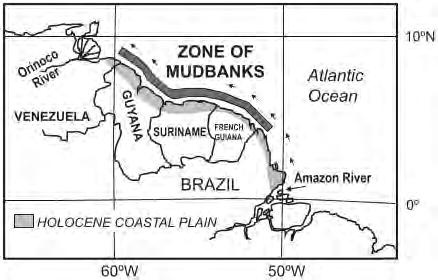
4 Mudbanks

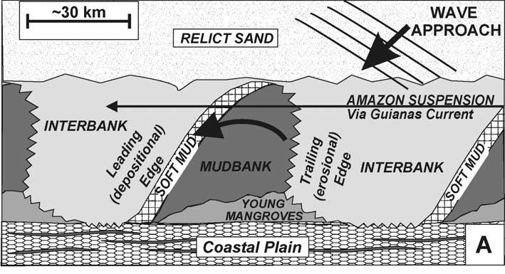
5 Allison and Lee, 2004

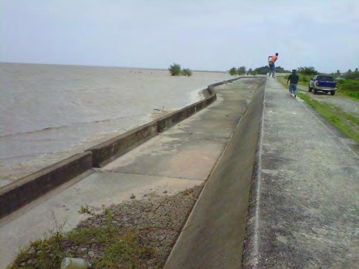
6 Leading Edge of the Mud Bank

7 Trailing Edge of the Mud Bank
8 Mangroves in Guyana Species Erosion Seawalls

9 Mangroves in Guyana Guyana s coastline is 430 Km. Portions of the upland lie 0.5m to 1.0m below sea level, and are protected by a system of sea defences amounting to 340km in length. Out of this 340 Km, sixty five percent (65%) is protected by Natural Sea Defence (Mangroves).

 is found on the coast while Rhizophora")
10 Mangroves in Guyana Guyana currently has 22,632 hectares of mangrove forest. Avicennia germainas (black mangrove) and Laguncularia (white mangrove) is found on the coast while Rhizophora mangle (red mangrove) is found in the riverine areas.

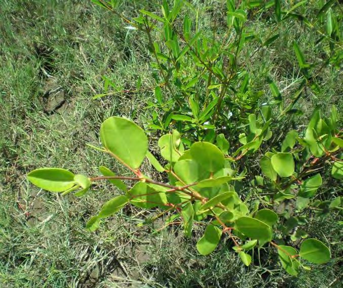
11 Black and White Mangrove
12 Typical Mangrove Cross Section

13 Crane, WCD


14 Crane, WCD

15 Crane, WCD
16 Standard Breakwater Design Sand (Tombolos and Salients) Galveston Mordecai Island
17 Types of Breakwaters In relation to the water level Emergent Submerged (also called sill) Attached or Detached Crest Width Narrow Wide Segmented By shape or orientation Generally shore parallel Chevron (for bi-directional waves) Angled

18 Detached Segmented Breakwater Note the salients and tombolos

19 Nearshore Curved Breakwater Note the change in wave energy from one side to the other Mordecai Island, NJ
20 Example Cross Section

21 NEARSHORE BREAKWATERS Galveston Island State Park, TX

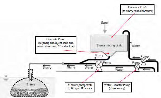
22 Scour Apron Grand Isle, Louisiana
 Fly Ash Lagoon,")
23 Scour Apron (reinforces the foundation) Fly Ash Lagoon, PA
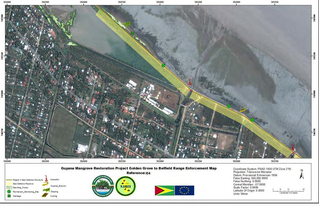
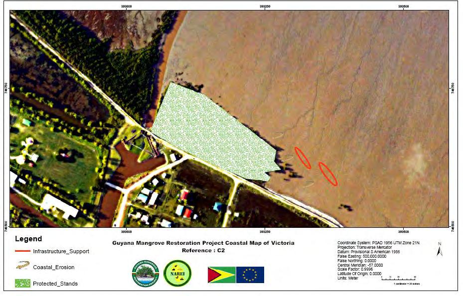
24 Design at Victoria, GY Geotextile Tubes and scour apron


25 Modelling the Tube

26 Plan at Victoria, ECD Plan View
27 Design Objectives Two (2) 50 meter sand filled geotextile tubes 20 ft circumference (8 feet wide by 4 feet high) sand-filled (260 cubic meters plus losses and anchor tubes) Two (2) 52 meter X 5.4 m scour aprons Double layer due to soft foundation Oriented to be perpendicular to incident waves at 60 degrees from magnetic north Designed to encourage tombolo growth which will capture more sediment and mud to raise the forseshore: proper elevation will promote revegetation Breakwaters will reduce future storm energy Breakwaters will reduce focusing of reflected wave energy off the seawall
28
29
30 Construction Geotextile Tubes and scour apron Filling Equipment
31 Fill Material Fill Gradation Tube Foundation Tube Alignment Tube Anchorage Tube Overlaps Tube Filling
32

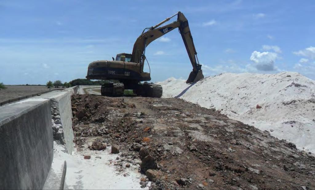
33 Sand on Site
34 Integrated Approach Contrast to no engineering Don t constrain mangroves behind seawalls
35 Lewis, Get the hydrology right first. 2. Do not build a nursery, grow mangroves and just plant some area currently devoid of mangroves (like) a convenient mudflat). There is a reason why mangroves are not already there or were not there in the recent past or have disappeared recently. 3. Once you find out why, see if you can correct the conditions that currently prevent natural colonization of the selected mangrove restoration site. If you cannot correct those conditions, pick another site..
36 Lewis, Use a reference mangrove site for examining normal hydrology for mangroves in your particular area. Either install tide gauges and measure the tidal hydrology of a reference mangrove forest or use the surveyed elevation of a reference mangrove forest floor as a surrogate for hydrology, and establish those same range of elevations at your restoration site or restore the same hydrology to an impounded mangrove by breaching the dikes in the right places.
37
38 The Use of Low Cost Breakwaters for Mangrove Restoration in Muddy Foreshores Conclusions Breakwaters, specifically ones constructed of geotextile tubes, may offer a relatively low cost approach to restoring and protecting mangroves Typical Breakwater Design has to be modified to suit the environment Site data and an understanding of the environment is crucial
Potential Application of. Shore-Stabilizing Structures along an Open-Coast Shoreline. Christopher G. Creed, P.E. 23 rd Annual National Conference on
 23 rd Annual National Conference on Potential Application of Beach Preservation Technology February 3-5, 2010 Indialantic, FL Shore-Stabilizing Structures along an Open-Coast Shoreline Christopher G. Creed,
On the Edge with Mangroves
 On the Edge with Mangroves (Author s Note: This is the twenty-second in a series of articles by members of the City of Sanibel Vegetation Committee dealing with vegetative matters of concern to island
Elkhorn Slough Tidal Wetland Project
 Elkhorn Slough Tidal Wetland Project Joint Meeting Strategic Planning Team and Science Panel September 23, 2009 Funding National Oceanic and Atmospheric Admin. David and Lucille Packard Foundation Resources
The Galveston Seawall
 Coastal and Ocean Engineering ENGI.8751 Undergraduate Student Forum Faculty of Engineering and Applied Science, Memorial University, St. John s, NL, Canada. March, 2013 The Galveston Seawall Mark Harvey
Guide to Siting of Seawalls January 13, 2014 by Michael Walther, P.E., D.CE, President - Coastal Tech
 January 13, 2014 by Michael Walther, P.E., D.CE, President - Coastal Tech mwalther@coastaltechcorp.com Prepared for the Sea Turtle Conservancy http://www.conserveturtles.org/ Introduction Overview: This
Terrestrial Protected Area Nomination: Central Mangrove Wetland South-West, Grand Cayman
 Terrestrial Protected Area Nomination: Central Mangrove Wetland South-West, Grand Cayman The attached nomination, proposing that a parcel of land in the Central Mangrove Wetland be made a Protected Area
CHAPTER 241. SAND BYPASSING TO "PLAYA DE CASTILLA" (HUELVA SPAIN) Jose Fernandez (1) Gregorio Gomez Pina (2) Angel Mufloz (3)
 Jose Fernandez (1) Gregorio Gomez Pina (2) Angel Mufloz (3)") CHAPTER 241 SAND BYPASSING TO "PLAYA DE CASTILLA" (HUELVA SPAIN) Jose Fernandez (1) Gregorio Gomez Pina (2) Angel Mufloz (3) Abstract The "Sand bypassing to Playa de Castilla" project consists of a sand
CHAPTER 241 SAND BYPASSING TO "PLAYA DE CASTILLA" (HUELVA SPAIN) Jose Fernandez (1) Gregorio Gomez Pina (2) Angel Mufloz (3) Abstract The "Sand bypassing to Playa de Castilla" project consists of a sand
Rising seas threaten to drown important mangrove forests, unless we intervene
 University of Wollongong Research Online Faculty of Science, Medicine and Health - Papers Faculty of Science, Medicine and Health 2015 Rising seas threaten to drown important mangrove forests, unless we
PROPOSED HORIZONTAL LAYOUT FILLET DESIGN FOR ENTRANCE/EXIT TAXIWAYS
 PROPOSED HORIZONTAL LAYOUT FILLET DESIGN FOR ENTRANCE/EXIT TAXIWAYS INTRODUCTION The Zelienople Airport Authority (ZAA) has commenced engineering activities for the rehabilitation of Runway 17-35 to a
BENEFICIAL USE OF DREDGED MATERIAL DISPOSAL HISTORY HOUMA NAVIGATION CANAL, LA
 BENEFICIAL USE OF DREDGED MATERIAL DISPOSAL HISTORY HOUMA NAVIGATION CANAL, LA 1991-2012 The Houma Navigation Canal (HNC) provides a navigation channel between Houma, Louisiana, and the Gulf of Mexico
Coastal protection and development of Alexandria
 Coastal protection and development of Alexandria R,M. Hassan* Coastal and Port Development Division, Water Engineering Dept,, IHE De~t, The Netherlands, Abstract Alexandria City is the main beach resort
Coastal Structures in Kagoshima Coastline, Japan Ejria Binti Saleh Universiti Malaysia Sabah, Sabah, Malaysia
 Coastal Structures in Kagoshima Coastline, Japan Ejria Binti Saleh Universiti Malaysia Sabah, Sabah, Malaysia Report for International Training Program to improve the study ability in biodiversity 1 1.0
The reasons why coastal management is needed in Minehead:
 1. Resource 1: Why did Minehead need new sea defences? Coastal management in Minehead In pairs, read the following resource and highlight the reasons why coastal management was needed in Minehead. The
FOR SALE Belize s World Heritage
 FOR SALE Belize s World Heritage The Pelican Cayes A Hotspot of Biodiversity and Destruction In the Belize Barrier Reef Reserve World Heritage Site March 2003 In the Pelican Cays, mangrove cays exhibit
Understanding user expectations And planning for long term sustainability 1
 Understanding user expectations And planning for long term sustainability 1 What is a natural surface trail? It can be as simple has a mineral soil, mulched or graveled pathway, or as developed as elevated
Appendix C. Past and Current Management of Selected Tidal Wetland Sites
 Appendix C. Past and Current Management of Selected Tidal Wetland Sites Maps and photographs of wetland sites can be found at http://www.elkhornslough.org/tidalwetlandproject. Site 1. Parsons Slough/South
Natural Selection and Ring Gliders
 Natural Selection and s Introduction: The purpose this lab is to use paper aircraft to model the process natural selection. A basic understanding aircraft design is not necessary to complete this lab but
80' MIN 100'-0" 15'-0" 2 FEDERALLY DREDGED NAVIGATION CHANNEL MEASURED AT EL -10' (NOTE 4) NAVIGATION CHANNEL EXISTING YACHT CLUB FLOATS
 NAVIGATION CHANNEL EXISTING YACHT CLUB FLOATS") 11 3 1 6 9 4 5 4 8 7 7 9 ' MUDLINE ELEVATION 8 1 6 11 6 1 7 8 5 7 7 12 11 5 12 7 8 9 5 11 8 REVISED FEDERAL LIMIT FOR DREDGING FEDERAL LIMIT FOR DREDGING 12 1 11 7 1 4 8 5 8 5 14 4 14 3 9 3 8 5 1 5 11
11 3 1 6 9 4 5 4 8 7 7 9 ' MUDLINE ELEVATION 8 1 6 11 6 1 7 8 5 7 7 12 11 5 12 7 8 9 5 11 8 REVISED FEDERAL LIMIT FOR DREDGING FEDERAL LIMIT FOR DREDGING 12 1 11 7 1 4 8 5 8 5 14 4 14 3 9 3 8 5 1 5 11
Cat Island Chain Background & Access Guide
 Cat Chain Background & Access Guide Brown County Port & Resource Recovery Department 2561 S. Broadway, Green Bay, WI 54304 (920) 492-4950 www.portofgreenbay.com January 2018 1 Restoration of the Cat Chain
Status of Mangroves in Belize
 Status of Mangroves in Belize State of the Coastal zone Summit June 7 th 2012 Nadia Bood*, Emil Cherrington and Tim Smith Outline Introduction to mangroves Importance of mangrove to Belize National status
MOSE PROJECT: STATE-OF-THE-ART AND FUTURE DEVELOPMENT
 AIPCN-France Third Mediterranean Days of Coastal and Harbour Engineering Troisièmes journées méditerranéennes de génie côtier et portuaire 23/05/2013 Marseille MOSE PROJECT: STATE-OF-THE-ART AND FUTURE
Thirteenth International Water Technology Conference, IWTC , Hurghada, Egypt 1249
 Thirteenth International Water Technology Conference, IWTC 13 2009, Hurghada, Egypt 1249 EVALUATION OF LOCAL SCOUR AROUND BRIDGE PIERS (RIVER NILE BRIDGES AS CASE STUDY) Sherine Ismail Assoc. Prof., Survey
CLYDE MAP 6: ERSKINE HARBOUR to north of DOVE COTTAGE
 CLYDE MAP 6: ERSKINE HARBOUR to north of DOVE COTTAGE Hinterland Geology and Coastal Geomorphology: The hinterland is dominated by marine deposits resting on undifferentiated glacial till. The foreshore
CORPS OF ENGINEERS ALASKA DISTRICT Dredging Projects. Michael Tencza, PE Operations Project Manager November 4, 2015
 CORPS OF ENGINEERS ALASKA DISTRICT 2016 Dredging Projects Michael Tencza, PE Operations Project Manager November 4, 2015 US Army Corps of Engineers Building and Preserving Alaska s Future AWARDED CONTRACTS
Engineering With Nature Geographic Project Mapping Tool (EWN ProMap)
") Engineering With Nature Geographic Project Mapping Tool (EWN ProMap) Cynthia Banks Program Manager Burton Suedel, PhD Research Biologist Michelle Bourne Research Biologist U.S. Army ERDC 23 June 2015 Dredging
Engineering With Nature Geographic Project Mapping Tool (EWN ProMap) Cynthia Banks Program Manager Burton Suedel, PhD Research Biologist Michelle Bourne Research Biologist U.S. Army ERDC 23 June 2015 Dredging
Reduction of Wave Runup on a Revetment by Addition of a Berm
 REMR Technical Note CO-RR-1.3 (Supersedes CO-RR-1.3 1986) Reduction of Wave Runup on a Revetment by Addition of a Berm Purpose To provide design guidance for reducing wave runup on a riprap revetment by
2011 Nags Head Beach Nourishment Project Update. Tim Kana & Haiqing Kaczkowski
 2011 Nags Head Beach Nourishment Project Update Tim Kana & Haiqing Kaczkowski NCBIWA Conference 3 April 2017 Outline of the Presentation 1 Review 2011 Nourishment Project Post-project monitoring efforts
1) Rescind the MOD (must meet the standard); 2) Issue a new MOD which reaffirms the intent of the previous MOD; 3) Issue a new MOD with revisions.
 Rescind the MOD (must meet the standard); 2) Issue a new MOD which reaffirms the intent of the previous MOD; 3) Issue a new MOD with revisions.") ALBUQUERQUE INTERNATIONAL SUNPORT AIRCRAFT HOLD LINE LOCATION ANALYSIS WHITE PAPER JUNE 24, 2016 HOLD LINE LOCATION ISSUE The location of many of the taxiway hold lines at the Sunport do not meet current
ALBUQUERQUE INTERNATIONAL SUNPORT AIRCRAFT HOLD LINE LOCATION ANALYSIS WHITE PAPER JUNE 24, 2016 HOLD LINE LOCATION ISSUE The location of many of the taxiway hold lines at the Sunport do not meet current
CHAPTER 186. Shore Protection Plan for the Nile Delta Coastline. A.L. Kadib, Member, ASCE^, A.T. Shak, A. Member, ASCE< 2 ), A.A.
, A.A.") CHAPTER 186 Shore Protection Plan for the Nile Delta Coastline A.L. Kadib, Member, ASCE^, A.T. Shak, A. Member, ASCE< 2 ), A.A. Mazen^3), and M.K. Nadar< 4 ) A Shore Protection Master Plan (SPMP) for the
CHAPTER 186 Shore Protection Plan for the Nile Delta Coastline A.L. Kadib, Member, ASCE^, A.T. Shak, A. Member, ASCE< 2 ), A.A. Mazen^3), and M.K. Nadar< 4 ) A Shore Protection Master Plan (SPMP) for the
IMPACTS OF THE RECENT TSUNAMI ON THE BUNDALA NATIONAL PARK THE FIRST RAMSAR WETLAND IN SRI LANKA
 IMPACTS OF THE RECENT TSUNAMI ON THE BUNDALA NATIONAL PARK THE FIRST RAMSAR WETLAND IN SRI LANKA by C.N.B. Bambaradeniya, IUCN The World Conservation Union, Sri Lanka Country Office (Email: cnb@iucnsl.org)
DAMAGE ASSESSMENT OF SAND FENCING GARDEN CITY, NORTH LITCHFIELD AND LITCHFIELD BEACH GEORGETOWN COUNTY, SC
 OF SAND FENCING GARDEN CITY, NORTH LITCHFIELD AND LITCHFIELD BEACH GEORGETOWN COUNTY, SC June 07, 2017 PREPARED FOR: GEORGETOWN COUNTY DEPARTMENT OF PUBLIC SERVICES PREPARED BY: The EARTHWORKS Group 11655
PORT EVERGLADES SAND BYPASS PROJECT
 28 th Annual National Conference on Beach Preservation Technology February 4, 2015 Clearwater Beach, FL PORT EVERGLADES SAND BYPASS PROJECT AN IMPORTANT FUTURE SAND SOURCE FOR SOUTHEAST FLORIDA BEACHES
Environmental Learning Outside the Classroom (ELOC)
") Environmental Learning Outside the Classroom (ELOC) This guidebook provides lesson ideas and activities to get students engaged with outdoor learning. Created by the Virgin Islands Marine Advisory Service
Environmental Learning Outside the Classroom (ELOC) This guidebook provides lesson ideas and activities to get students engaged with outdoor learning. Created by the Virgin Islands Marine Advisory Service
DELOS EVK3-CT Deliverable No 5 for WP1.1 LCS in IT UR3/MOD part Based on the brief questionnaire
 DELOS EVK3-CT2000-0041 Deliverable No 5 for WP1.1 LCS in IT UR3/MOD part Based on the brief questionnaire This document summarizes the information collected for DELOS WP1.1 Inventory of engineering properties
EFFECT OF THE COASTAL CONSERVATION DUE TO BEACH NOURISHMENT OF TOTORI SAND DUNE COAST
 Proceedings of the 7 th International Conference on Asian and Pacific Coasts (APAC 203) Bali, Indonesia, September 2-26, 203 EFFECT OF THE COASTAL CONSERVATION DUE TO BEACH NOURISHMENT OF TOTORI SAND DUNE
Using Managed Retreat to Address Coastal Erosion in Brewster
 Using Managed Retreat to Address Coastal Erosion in Brewster Chris Miller, Director, Brewster Department of Natural Resources CMiller@brewster-ma.gov Brewster, Massachusetts Almost 1/3 of town preserved
Picnic Units A picnic unit is a part of a picnic area
 Grab Bars Grab bars are usually provided in buildings to provide stability and allow a person to use his or her arms to assist in movement over short distances. The most common location for grab bars is
CUBICLE BEDDING. 22 Tel. (+31)(0) Fax. (+31)(0)
(0) Fax. (+31)(0)") CUICLE EDDING We at eerepootgri are convinced of the importance of a the total embodiment of a good resting place for your cows. The main thing that cows require is to lie down and rest. That is why we
CUICLE EDDING We at eerepootgri are convinced of the importance of a the total embodiment of a good resting place for your cows. The main thing that cows require is to lie down and rest. That is why we
Chapter 10. Damage to Ports and Coastal Facilities
 Chapter 10 Damage to Ports and Coastal Facilities 10.1 Area Investigated Tsunami induced heavy damage to ports and coastal facilities along the west and north coast of Sumatra Island. Figure 10.1 shows
City of Fort Lauderdale. Frequently Asked Questions. Proposed Sea Wall Ordinance
 City of Fort Lauderdale Frequently Asked Questions Proposed Sea Wall Ordinance The City of Fort Lauderdale is considering amending the Unified Land Development Regulations of the City of Fort Lauderdale
KINGSTON HARBOUR IN THE YEAR SEMINAR SPONSORED BY NEPA 2003 November 06
 KINGSTON HARBOUR IN THE YEAR 2025 SEMINAR SPONSORED BY NEPA 2003 November 06 NORMAN MANLEY INTERNATIONAL AIRPORT (NMIA) RUNWAY EXPANSION URGENTLY REQUIRED AT NMIA NMIA Brief History Previously named Palisadoes
Lidar Imagery Reveals Maine's Land Surface in Unprecedented Detail
 Maine Geologic Facts and Localities December, 2011 Lidar Imagery Reveals Maine's Land Surface in Unprecedented Detail Text by Woodrow Thompson, Department of Agriculture, Conservation & Forestry 1 Introduction
DOES BEACH NOURISHMENT PROTECT PROPERTY VALUES FROM HURRICANES? THE CASE OF THE 2004 AND 2005 HURRICANES
 DOES BEACH NOURISHMENT PROTECT PROPERTY VALUES FROM HURRICANES? THE CASE OF THE 2004 AND 2005 HURRICANES James Murley, Director, Center for Urban and Environmental Solutions (CUES), FAU Dr. Lenore Alpert,
Impact of Offshore Directed Forcing on Sediment Transport and Structural Integrity at Packery Channel, Corpus Christi Texas
 Google Earth 29 Aug 2017 Impact of Offshore Directed Forcing on Sediment Transport and Structural Integrity at Packery Channel, Corpus Christi Texas Deidre D. Williams Coastal Research Scientist Conrad
^ox, 7. Environment Agency. Hayling Island North Strategy *. M ^, v. * > -.
 ^ox, 7 Environment Agency Hayling Island North Strategy *. M ^, v. * > -. Consultation Document for Preferred Coastal Defence Options - Septem ber 2005 We are the Environment Agency. It s our job to look
Leptis Magna. 9 LEPTIS MAGNA s NORTH COAST
 9 LEPTIS MAGNA s NORTH COAST The following observations were made on August 24, 25 and 26, 2000, thanks to the kind hospitality of the late Professor André Laronde during his year 2000 campaign of the
TRANSMITTAL. Please contact me with any questions. 7 Spruce Road, Freeport, ME T: (207)
") BAKER DESIGN CONSULTANTS Civil, Marine and Structural Engineering To: Alex Jaegerman FAICP Director of Planning & Development Town of Yarmouth 200 Main Street PO Box 907 Yarmouth, ME 04096 From: Barney
BAKER DESIGN CONSULTANTS Civil, Marine and Structural Engineering To: Alex Jaegerman FAICP Director of Planning & Development Town of Yarmouth 200 Main Street PO Box 907 Yarmouth, ME 04096 From: Barney
www: vermilionparishpolicejury.com
 www: vermilionparishpolicejury.com 1 Coastal Projects in Vermilion Parish Constructed over the last 26 years (CWPPRA, CIAP, State Surplus) PPL Number Project Name Project Types Current Estimate Acres
Runway Roughness Evaluation- Boeing Bump Methodology
 FLIGHT SERVICES Runway Roughness Evaluation- Boeing Bump Methodology Michael Roginski, PE, Principal Engineer Boeing Airport Compatibility Engineering ALACPA X Seminar, Mexico City, Mexico September 30-
Diversity of Coastal Ecosystems of Maharashtra - Ecologically Sensitive Coastal Areas of Ratnagiri and Sindhudurga
 Diversity of Coastal Ecosystems of Maharashtra - Ecologically Sensitive Coastal Areas of Ratnagiri and Sindhudurga Abstract: Approximately 20% of the world s coral reefs were lost and an additional 20%
Runway Roughness Evaluation- Boeing Bump Methodology
 FLIGHT SERVICES Runway Roughness Evaluation- Boeing Bump Methodology Michael Roginski, PE, Principal Engineer Boeing Airport Compatibility Engineering ALACPA X Seminar, Mexico City, Mexico September 3-
c. 1 inch = 0.6 miles e. 1:100,000 f. 1:250,000 f. 1 inch = 4.0 miles
 High School Advance Geology Map Test 2014 Name Use the information on each map to provide the best answer to the questions. Fill in the bubble of the best answer on your answer sheet. Answer questions
STRATEGIES FOR PROTECTING YOUR PROPERTY
 STRATEGIES FOR PROTECTING YOUR PROPERTY A Homeowner s Guide for Flood, Debris, and Erosion Control after the High Park Fire (Includes tips on how to properly use sandbags) Larimer County Engineering Department
Distribution of Mangroves along the Red Sea Coast of the Arabian Peninsula: Part 2. The Southern Coast of Western Saudi Arabia
 Distribution of Mangroves along the Red Sea Coast of the Arabian Peninsula: Part 2. The Southern Coast of Western Saudi Arabia M. Asif Khan, Arun Kumar*and Abdul Muqtadir Center for Petroleum and Minerals,
The Maltese Islands: Geography
 The Maltese Islands: Geography The Maltese Archipelago comprises a group of small low islands aligned in a NW-SE direction. At their extreme points the Maltese Islands fall within the following points:
Mountain Valley Pipeline, LLC Mountain Valley Pipeline Project Docket No. CP
 16. Prior to construction, Mountain Valley shall file with the Secretary, for review and approval by the Director of OEP, a segment-specific construction and operation access plan for the area between
Defending the coast at Dawlish Warren
 508 546 Sólheimajökull: Defending the coast a retreating Dawlish Icelandic Warrenglacier By By Simon Hilary Edge Sampson Today, ice covers around 10% of the A case study about world s surface. But, for
Great Lakes Navigation System Buffalo District
 Great Lakes Navigation System Buffalo District Josh Feldmann U.S. Army Corps of Engineers Chief, Operations Branch 9 FEB 2016 US Army Corps of Engineers BUILDING STRONG Key FY16/17 Buffalo District O&M
Provincial Development and Physical Framework Plan Province of Capiz
 3.2.3 Protection Areas Protection areas (Map 11) which include areas under the categories of NIPAS, Non-NIPAS, environmentally constrained and the military reservations are described as follows: a) NIPAS
Gatwick Stream Riverside Garden Park, Horley
 Gatwick Stream Riverside Garden Park, Horley An Advisory Visit by the Wild Trout Trust January 2014 1 1. Introduction This report is the output of a Wild Trout Trust visit to the Gatwick Stream in Horley,
Cultural Resource Management Report Deer Valley 4wd Restoration and Blue Lakes Road Maintenance Project R
 Cultural Resource Management Report R2015-05-03-10005 Undertaking Description: The proposes to perform road maintenance and meadow restoration on the Deer Valley 4wd trail and road maintenance on the Blue
Kennesaw Mountain Trail Club. Trail Skills Workshop ~ Dips and Drains. Presented by: Jay M Dement
 Kennesaw Mountain Trail Club Trail Skills Workshop ~ Dips and Drains Presented by: Jay M Dement KEY CONCEPTS: Control Erosion and Users Where Do Trails Come From, and How Do They Work: Concept of trail
REPORT OF STUDY TRIP (TOHOKU)
") INTERNATIONAL INSTITUTE OF SEISMOLOGY AND EARTHQUAKE ENGINEERING (IISEE) REPORT OF STUDY TRIP (TOHOKU) 10-14 JULY 2011 PREPARED BY: MAZNI BINTI AZIS MALAYSIA SUBMISSION DATE: JULY 29, 2011 TSUNAMI DISASTER
INTERNATIONAL INSTITUTE OF SEISMOLOGY AND EARTHQUAKE ENGINEERING (IISEE) REPORT OF STUDY TRIP (TOHOKU) 10-14 JULY 2011 PREPARED BY: MAZNI BINTI AZIS MALAYSIA SUBMISSION DATE: JULY 29, 2011 TSUNAMI DISASTER
Airport Master Plan Update June 15, 2017
 Airport Master Plan Update June 15, 2017 www.harveyfield.com The Master Plan is a 20-year plan to understand the needs of current and future users of the Airport. This is important to ensure that safe
Airport Master Plan Update June 15, 2017
 Airport Master Plan Update June 15, 2017 www.harveyfield.com The Master Plan is a 20-year plan to understand the needs of current and future users of the Airport. This is important to ensure that safe
Mr. Michael Malone CPS Energy 145 Navarro Street San Antonio, Texas Project No
 January 15, 2016 Mr. Michael Malone 145 Navarro Street San Antonio, Texas 78205 Project No. 0328985 Environmental Resources Management CityCentre Four 840 West Sam Houston Pkwy N. Suite 600 Houston, Texas
Update Report - Etobicoke Creek and South Mimico Creek Trails
 REPORT FOR ACTION Update Report - Etobicoke Creek and South Mimico Creek Trails Date: October 23, 2017 To: Etobicoke York Community Council From: General Manager, Parks Forestry and Recreation Wards: Ward
Runway Roughness Evaluation- Boeing Bump Methodology
 FLIGHT SERVICES Runway Roughness Evaluation- Boeing Bump Methodology Michael Roginski, PE, Principal Engineer Boeing Airport Compatibility Engineering ALACPA XI Seminar, Santiago, Chile September 1-5,
Coastal Impact on barrier Islands: Application to Praia de Faro
 Coastal Impact on barrier Islands: Application to Praia de Faro Theocharis Plomaritis, Oscar Ferreira and Susana Costas RISCKIT Final Meeting This project has received funding from the European Union s
Coastal and marine ecosystems provide vitally
 Coastal Capital: Belize The Economic Contribution of Belize s Coral Reefs and Mangroves Coastal and marine ecosystems provide vitally important goods and services to countries in the Caribbean. This study
Marine Exchange of Alaska Port of Juneau Navigation Study
 Safe, Secure, Efficient and Environmentally Responsible Maritime Operations 1000 Harbor Way, Juneau, Alaska 99801 Ph: (907) 463-2607 December 10, 2008 Mr. John Stone Port Director City of Juneau 155 S.
MONTAGUE HARBOUR MARINE PROVINCIAL PARK
 MONTAGUE HARBOUR MARINE PROVINCIAL PARK PURPOSE STATEMENT AND ZONING PLAN March 2003 1 MONTAGUE HARBOUR MARINE PROVINCIAL PARK Purpose Statement and Zoning Plan Primary Role The primary role of Montague
REPORT OF STUDY TRIP (TOHOKU)
") INTERNATIONAL INSTITUTE OF SEISMOLOGY AND EARTHQUAKE ENGINEERING (IISEE) REPORT OF STUDY TRIP (TOHOKU) 14 18 November 2011 Prepared by: Nur Intan Irzwanee Nurashid T course (Malaysia) 5/12/2011 Day 1:
INTERNATIONAL INSTITUTE OF SEISMOLOGY AND EARTHQUAKE ENGINEERING (IISEE) REPORT OF STUDY TRIP (TOHOKU) 14 18 November 2011 Prepared by: Nur Intan Irzwanee Nurashid T course (Malaysia) 5/12/2011 Day 1:
2012 Texas Water Conservation Association Meeting
 2012 Texas Water Conservation Association Meeting BG Thomas Kula Southwestern Division Commander 15 June 2012 US Army Corps of Engineers AGENDA UNCLASSIFIED Overview of Southwestern Division Missions Texas
AIRBORNE SCIENCE FLIGHT REQUEST National Aeronautics and Space Administration
 AIRBORNE SCIENCE FLIGHT REQUEST National Aeronautics and Space Administration LOG NUMBER Investigation Title: Rationale for use of NASA Facilities: NASA RTOP If checked, RTOP Number/Grant or Contract #
10.7 Acre Oceanfront North Rendezvous Island
 10.7 Acre Oceanfront North Rendezvous Island Jamie Zroback jamie@landquest.com 1 (604) 483-1605 Jason Zroback jason@landquest.com 1 (604) 414-5577 The Source for Oceanfront, Lakefront, Islands, Ranches,
ICRI Monaco January 2010
 Economic Valuation of Coral Reefs in the Caribbean ICRI Monaco January 2010 Lauretta Burke World Resources Institute (WRI) Beautiful Valuable Valuable Valuable Valuable Valuable Photos: Krishna Desai Valuable
Stakeholder Meeting #1. An Introduction to the Blind Pass Inlet Management Study
 Stakeholder Meeting #1 An Introduction to the Blind Pass Inlet Management Study April 21, 2016 5:30 PM, The Sanctuary, Sanibel Island A World of Solutions 0 Agenda Introductions Study Overview Study Status
North Cruise Berth Projects PortMiami
 North Cruise Berth Projects PortMiami AAPA 2017 Facilities Engineering Seminar Oct 24 26, 2017 Carlos J. Arboleda, PE Vice President Project Director Intermodal Ports 1 PortMiami The Cruise Capital of
Preparing for Larger Cruise Vessels. Gary Ledford AAPA Facilities Engineering Seminar November 17, 2009
 Preparing for Larger Cruise Vessels Gary Ledford AAPA Facilities Engineering Seminar November 17, 2009 Bigger is Better (for the cruise lines) Current Ships New Ships LOA (ft) 965 1116-1180 Beam (ft) 106
FOR SALE INDIAN OCEAN BEACHFRONT- HEADLAND PLOT
 June 2017 FOR SALE INDIAN OCEAN BEACHFRONT- HEADLAND PLOT Rasini, Kimbiji, Kizito Huonjwa, Temeke, Dar es Salaam, Tanzania A UNIQUE opportunity to acquire 9 hectares/22 acres of natural cliff and beachfront
Addendum - Airport Development Alternatives (Chapter 6)
") Bowers Field Addendum - Airport Development Alternatives (Chapter 6) This addendum to the Airport Development Alternatives chapter includes the preferred airside development alternative and the preliminary
Bowers Field Addendum - Airport Development Alternatives (Chapter 6) This addendum to the Airport Development Alternatives chapter includes the preferred airside development alternative and the preliminary
Draft Length 10 Thorness Bay to Cowes Chain Ferry
 Draft Length 10 Thorness Bay to Cowes Chain Ferry Introduction The southern section of this length of coast is largely (mud and sand) beach edged with landslip. Landward of this is agricultural land with
Assignment 7: Airport Geometric Design Standards
 CEE 4674: Airport Planning and Design Spring 2018 Date Due: March 23, 2018 Instructor: Trani Problem 1 Assignment 7: Airport Geometric Design Standards An airport is designing a new pier terminal to accommodate
Economic Impacts of Beach Nourishment in Texas
 Galveston Island South Padre Island April 25, 2017 Economic Impacts of Beach Nourishment in Texas Michael Walther Coastal Tech G.E.C., Inc. Reuben Trevino - Galveston Island Park Board of Trustees Special
Large Airtanker Scenario (Scenario 1: Regional Fire)
") Large Airtanker Scenario (Scenario 1: Regional Fire) ABN 96 105 736 392 Level 5 / 340 Albert Street EAST MELBOURNE VICTORIA 3002 AUSTRALIA tenders@nafc.org.au Copyright 2012, All rights reserved. Copyright
Large Airtanker Scenario (Scenario 1: Regional Fire) ABN 96 105 736 392 Level 5 / 340 Albert Street EAST MELBOURNE VICTORIA 3002 AUSTRALIA tenders@nafc.org.au Copyright 2012, All rights reserved. Copyright
REPORT IN-017/2011 DATA SUMMARY
 REPORT IN-017/2011 DATA SUMMARY LOCATION Date and time Thursday, 9 June 2011 at 09:40 UTC 1 Site Tenerife North Airport (GCXO), Tenerife AIRCRAFT Registration Type and model Operator EC-KDP PIPER PA-34-200T
DATE: 23 March, 2011 TO: Communities FROM: BlazeSports America. RE: Accessible Trails Checklist 1
 M E M O R A N D U M DATE: 23 March, 2011 TO: Communities FROM: BlazeSports America RE: Accessible Trails Checklist 1 The purpose of the Accessible Trails Checklist (below) is to help the community review
Runway and Taxiway Marking
 Lecture-38 10CV63 TE-II Runway and Taxiway Marking In order to aid pilots in guiding the aircraft on runways and taxiways, pavements are marked with lines and numbers. These markings are of benefit primarily
Outline of the Shinryu Head Works
 Outline of the Shinryu Head Works Midori Network Water and farmland protection Midori Network Shinryu 1. History Land reclamation began in 1890 under the initiative of the Uryu Aristocratic Farm, headed
Clam Harbour Provincial Park
 Clam Harbour Provincial Park Public Engagement Session Thursday, September 14 th, 2017 5:30pm 7:30pm Webbers Store 11470 Nova Scotia Trunk 7 Lake Charlotte, NS Agenda Overview of the Provincial Parks System
The Vjosa River in Albania
 The Vjosa River in Albania Europe s Wild jewel - beautiful, unknown and threatened The extensive braided river section near Tepelena would drown in a reservoir of the future Kalivaç dam. (Romy Durst) Major
Hammer, Discus, Shot Put, Javelin
 Hammer, Discus, Shot Put, Javelin Competition Aluminium Discus And Hammer Cage 7/10 M The competition aluminium discus and hammer cage is made from extra sturdy aluminium profiles. The profile measures
Design and Construction of Berm Breakwaters
 Design and Construction of Berm Breakwaters Jentsje van der Meer - Van der Meer Consulting UNESCO-IHE Sigurdur Sigurdarson - Icelandic Road and Coastal Administration IceBreak Consulting Engineers New
Pen y Chain to Trwyn Cilan
 PDZ 13. THE SOUTH LLYN BAYS: Abersoch Pen y Chain to Trwyn Cilan CONTENTS Page PDZ 13 THE SOUTH LLYN BAYS: 257 1 Local Description 260 2 Coastal Processes 265 3 Management Scenarios 275 4 Summary Comparison
Sandbag Barrier. Suitable Applications Sandbag barriers may be suitable: As a linear sediment control measure:
 Categories EC Erosion Control SE Sediment Control TC Tracking Control WE Wind Erosion Control Non-Stormwater NS Management Control Waste Management and WM Materials Pollution Control Legend: Primary Category
BRAND-OGRAPHY. Katarina Baumann
 BIRD ISLAND PELICAN POINT POWER STATION OUTER HARBOR NORTH HAVEN BIODIVERSITY PARK MUTTON COVE ADELAIDE LEFEVRE PENINSULA Scale 1:25000 NORTH HAVEN MARINA TAPEROO FORMER PENRICE FACTORY SITE TORRENS ISLAND
GC 225 Lecture Exam #2
 GC 225 Lecture Exam #2 Direction- path along which something is moving. 3 Types; - COMPASS DIRECTIONAL NAME (32 in total) - BEARING (four 0 o - 90 o ) - AZIMUTHS (0 o - 360 o ) Compass (32 named points)
Mulberry Harbour. Port Winston, what was it and what remains now.. Chris Howlett Howlett Hydrographic Services
 Mulberry Harbour Port Winston, what was it and what remains now.. Chris Howlett Howlett Hydrographic Services Mulberry Harbours Mulberry Harbour What were the Harbours? What is left today? The Survey What
Unit 1 Lesson 1: Introduction to the Dry Tortugas and Sustainable Seas Expedition
 Unit 1 Lesson 1: Introduction to the Dry Tortugas and Sustainable Seas Expedition Lesson Objectives: Introduce students to the historical, geographic, and ecological importance of the Dry Tortugas. Introduce