IMPACTS OF THE RECENT TSUNAMI ON THE BUNDALA NATIONAL PARK THE FIRST RAMSAR WETLAND IN SRI LANKA
|
|
|
- Zoe McKenzie
- 5 years ago
- Views:
Transcription
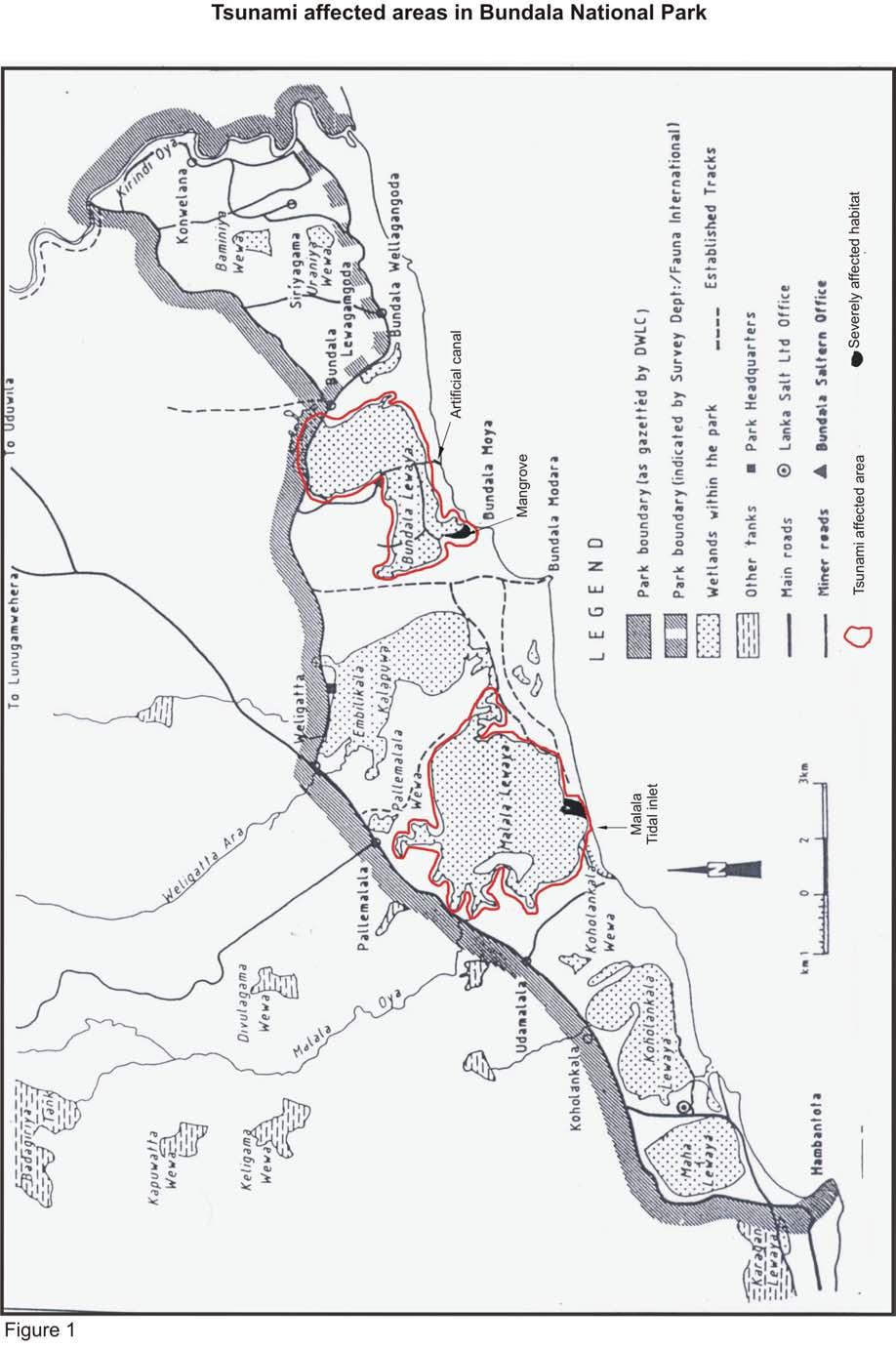
1 IMPACTS OF THE RECENT TSUNAMI ON THE BUNDALA NATIONAL PARK THE FIRST RAMSAR WETLAND IN SRI LANKA by C.N.B. Bambaradeniya, IUCN The World Conservation Union, Sri Lanka Country Office ( INTRODUCTION The Bundala National Park (BNP), covering an area of 6216 ha, is located about 250 Km Southeast of Colombo, in the Hambantota District (6º08 6º14 N, 81º08-81º18 E) (Figure 1.1). The park falls within the Southeastern Arid Zone of Sri Lanka, with a general climate that can be classified as hot and dry. Topographically, the park is generally flat with sand dunes varying in width from about m bordering the coastline. Three streams, Malala Oya, Embilikala Oya and Kirindi Oya discharge their waters into the park and adjacent areas. The park consists mainly of dry thorny scrubland and lagoons. The shallow brackish water lagoons located within the park includes Koholankala (390 ha), Malala (650 ha), Embilikala (430 ha) and Bundala (520 ha). The Malala and Embilikala lagoons are interconnected by a natural canal, and receive drainage water from the Badagiriya and Kirindi Oya irrigation systems, respectively. A part of the core area of the BNP is the 50 m width of beach extending along a 12 km. stretch. In relation to biodiversity, the BNP consists of a total of 11 major habitats/vegetation types (Bambaradeniya et al., 2003). These include 7 terrestrial vegetation types and 7 wetland types. The terrestrial habitats consist of dry thorny scrubland, arid zone forests, sand dune vegetation, gentle sea shore vegetation, arid zone maritime grasslands/pastures, riverine forests, and anomalous Mesquite (Prosopis) scrublands, while the wetland types include saltmarsh, mangrove, brackish water lagoons, sea shore (sandy and rocky), saltern, water holes/tanks and streams. A total of 383 plant species, 1
2 belonging to 90 families were documented from the above vegetation and habitat types in Bundala (Bambaradeniya et al., 2003). These include six endemics and seven species that are nationally threatened, while 15 are invasive alien species. Of the total plant species documented from Bundala, 121 are woody species. The animals documented from Bundala include a total of 324 species of vertebrates, of which 11 species are endemic, while 29 species are nationally threatened. The vertebrates include 32 species of fish, 15 species of amphibians, 48 species of reptiles, 197 species of birds, and 32 species of mammals. Among the invertebrates are 52 species of colourful butterflies. TSUNAMI RELATED IMPACTS ON THE BNP A rapid environmental assessment was conducted in the BNP two weeks subsequent to the Tsunami, to gather information on the damage caused to the park and its biodiversity. Qualitative observations were made on the structural damage caused to the habitats/vegetation types of BNP, and information was also gathered from park managers and the local communities living around BNP. In general, the BNP and the adjoining Bundala village have been well protected by a broad, mature and stabilized sand dune running parallel to the coastline. The following observations were made in the BNP, subsequent to the recent Tsunami. The beach area in BNP has been subjected to erosion, resulting in the reduction of the cover of gentle sea-shore vegetation that consists of runners and creepers such as Ipomoea pescapre and Spinifex littoreus. In certain locations, the cover of this coastal vegetation type has been reduced up to 75%. The erosion of beach in turtle nesting areas has resulted in the destruction of at least 75 turtle nests (mainly belonging to Green Turtle and Olive Ridley Turtle) that were present in the Wellagangoda beach stretch. 2
3 Cutting of an artificial canal across the mature sand dune bordering the Bundala lagoon (by the Bundala Salt Company to drain saline water from the Salt tern) has resulted in funneling of sea water into the lagoon, resulting in sea water incursion into the Bundala lagoon and the Salt tern, destroying the salt pans. The receding water has also resulted in the destruction of the only mangrove habitat (0.5 ha) that occurred at the natural tidal inlet area of the Bundala lagoon. Scattered debri consisting of dead plant material and non-biodegradable material was observed in the Bundala lagoon and the surrounding environment. The sand bar formed across the tidal inlet of the Malala lagoon had been penetrated by the sea water that had funneled into the lagoon. The tidal inlet (lagoon mouth) of Malala had been widened subsequent to the Tsunami, resulting in the drainage of water in the Malala and the connected Embilikala lagoon. Many species of freshwater fish inhabiting these two lagoons had been subjected to mass mortality due to increased saline conditions. Dead specimens of Channa striata were observed in the edge of the lagoon. Fishermen involved in fishing activities in the Malala lagoon informed of a considerable reduction in fish catches in the lagoon subsequent to the Tsunami. Deposition of mud and sand was observed in small patches of maritime grasslands and saltmarsh habitats bordering the Malala lagoon, resulting in the destruction of vegetation in these habitats. The invasive alien reed Typha angustifolia that covered a considerable area of the Embilikala lagoon and its canal that links it with the larger Malala lagoon was completely destroyed as a result of increase salinity. This has resulted in the exposure and destruction of nesting sites of some native aquatic avifauna. Clumps of the invasive alien Prickly-pear cactus (Opuntia dillenni) that were prevailant in the beach area of Bundala have been washed off inshore through the 3
4 Malala tidal inlet and the Bundala artificial canal, and these were observed to be regenerating in new areas where they have been deposited. Some trees of the narrow riverrine forest located on the border of the Kirindi-oya had been uprooted by the sea water that had been funneled in through the river mouth. OBSERVATIONS AND REMARKS ON NATURAL RECOVERY OF AFFECTED HABITATS AND SPECIES The eroded beach stretches bordering the BNP would be able to recover naturally over a short period of time (1-2 years), by the sand carried out to the ocean by the Kirindi-oya and the Bandagariya irrigation systems. The gentle sea-shore vegetation in the affected beach would also be able to recover naturally from the remaining vegetation, within 1-2 years. The DWC staff at BNP informed that Green Turtle and the Olive Ridley Turtle are returning to the beach areas for nesting in small numbers, which indicates a gradual recovery of turtles that visit Bundala for nesting. The aquatic birds (including natives and migrants) observed in the lagoons of BNP was healthy, in relation to population numbers and species composition. The terrestrial habitats inundated by sea water may be subjected to a rapid invasion by the invasive alien Mesquite (Prosopis juliflora), as it spreads well in saline soils. The breached sand bar across the Malala lagoon has now been re-established, and the drained Malala and Embilikala lagoons will be filled with water within a short period of time. 4
5 RECOMMENDATIONS FOR ACTION Propagules of the invasive alien Prickly-pear cactus transported to inland areas by the Tsunami waves should be collected and destroyed. The destroyed patch of mangrove located at the tidal inlet area of the Bundala lagoon should be restored with seedlings of Lumnitzera racemosa. Non-biodegradable material scattered in the lagoons and surrounding areas should be collected and destroyed. A scientific monitoring programme should be carried out to monitor the marine turtles that visit the beach area of the BNP for nesting Strengthen and re-activate the marine turtle in-situ conservation programme carried out by the DWC prior to the Tsunami in BNP. Monitor the spread of Mesquite (Prosopis juliflora) in areas inundated with sea water resulting from the Tsunami waves. 5
6 6
7 References Bambaradeniya, C.N.B., S.P. Ekanayake, R.H.S.S. Fernando, W.P.N. Perera and R. Somaweera (2003). A biodiversity status profile of Bundala National Park A Ramsar wetland in Sri Lanka. Occ. Pap. IUCN Sri Lanka., 2:iii+ 37pp. 7
Region 1 Piney Woods
 Region 1 Piney Woods Piney Woods 1. This ecoregion is found in East Texas. 2. Climate: average annual rainfall of 36 to 50 inches is fairly uniformly distributed throughout the year, and humidity and temperatures
5 proposed wetland sites
 PROPOSED WETLAND SITES OF VIETNAM Hoang Van Thang, PhD. 5 proposed wetland sites 1. Lak Lake 2. Lo Go Sa Mat 3. Tram Chim 4. UMi Minh hthuong 5. Mui Ca Mau Lak Lake Coordinates: 12o24 22 12o26 25 N 108o09
EUROPEAN COMMISSION DG XI.D.2. COUNCIL DIRECTIVE 79/409/EEC on the conservation of wild birds. and
 EUROPEAN COMMISSION DG XI.D.2 COUNCIL DIRECTIVE 79/409/EEC on the conservation of wild birds and COUNCIL DIRECTIVE 92/43/EEC on the conservation of natural habitats and of wild fauna and flora STANDARD
Satoquo SEINO (Graduate School of Engineering, Kyushu University, Japan)
") A reconsideration of horseshoe crab conservation methodology in Japan over the last 100 years and prospects for a marine protected area network in Asian seas Satoquo SEINO (Graduate School of Engineering,
A reconsideration of horseshoe crab conservation methodology in Japan over the last 100 years and prospects for a marine protected area network in Asian seas Satoquo SEINO (Graduate School of Engineering,
Pre and Post Tsunami Coastal Planning and Land Use Policies and Issues in Sri Lanka. Sri Lanka. Maritime Zones of Sri Lanka
 Pre and Post Tsunami Coastal Planning and Land Use Policies and Issues in Sri Lanka Maritime Zones of Sri Lanka By Dr. R.A.D.B. SAMARANAYAKE IMPORTANCE OF COASTAL ZONE The Coast line is 1620 km in length
Title/Name of the area: Chwaka Bay, Zanzibar
 Title/Name of the area: Chwaka Bay, Zanzibar Presented by: Dr. Charles Lugomela, Ag. Head, Department of Aquatic Sciences and Fisheries, University of Dar es Salaam, P.O. Box 35064 Dar es Salaam, Tanzania
Case Study: 1. The Clarence River Catchment
 Case Study: 1. The Clarence River Catchment The NSW coastline is a great natural asset, making an enormous contribution to the economy. The resources of coastal catchments such as the Clarence River Catchment,
Bazaruto Archipelago National Park-Mozambique. Mozambique. Workshop on MPAs- Is MPAs a useful tool In Fisheries management?
 Bazaruto Archipelago National Park-Mozambique Workshop on MPAs- Is MPAs a useful tool In Fisheries management? Norway ; 24-25 25 October 2006 By Paula Santana Afonso Institute for Fisheries Research Mozambique
Wetlands Reservoirs of Biodiversity. Billy McCord, SCDNR
 Wetlands Reservoirs of Biodiversity Billy McCord, SCDNR Estuaries Tidal Deepwater Intertidal Salt Marsh Tidal Riverine Fresh & Brackish Deepwater Tidal Emergent Marsh Freshwater Riverine Seasonally Flooded
Planning a National Aquatic Area Network (NAAN) for Conservation & Management of Rare, Threatened & Endangered Wetland Biodiversity
 for Conservation & Management of Rare, Threatened & Endangered Wetland Biodiversity") Planning a National Aquatic Area Network (NAAN) for Conservation & Management of Rare, Threatened & Endangered Wetland Biodiversity B.C. Choudhury bcc@wii.gov.in Keynote Presentation on Biodiversity &
Planning a National Aquatic Area Network (NAAN) for Conservation & Management of Rare, Threatened & Endangered Wetland Biodiversity B.C. Choudhury bcc@wii.gov.in Keynote Presentation on Biodiversity &
photos Department of Environment and Conservation Biodiversity Conservation
 photos Department of Environment and Conservation Biodiversity Conservation EcoEducation - making the connections to biodiversity conservation Do you consider experiential learning of biodiversity in the
What Is An Ecoregion?
 Ecoregions of Texas What Is An Ecoregion? Ecoregion a major ecosystem with distinctive geography, characteristic plants and animals, and ecosystems that receives uniform solar radiation and moisture Sometimes
On the Edge with Mangroves
 On the Edge with Mangroves (Author s Note: This is the twenty-second in a series of articles by members of the City of Sanibel Vegetation Committee dealing with vegetative matters of concern to island
Biosphere Reserve of IRAN. Mehrasa Mehrdadi Department of Environment of IRAN
 Biosphere Reserve of IRAN Mehrasa Mehrdadi Department of Environment of IRAN Biodiversity in Iran Comprises a land area of 1.64 million km² The average altitude is over 1200 m, Is bordered by Turkmenistan,
State of Nature 2016
 State Nature 2016 State Nature 2016 Results look up tables This document presents tables the results referred to in the report in an easy to access format. All data presented here feature in the report
INTRODUCTION Background: Definitions Wetlands in Egypt Threats to Wetlands Wetland Services
 INTRODUCTION Background: Definitions Wetlands in Egypt Threats to Wetlands Wetland Services NATIONAL STRATEGY Mission: Goal Guiding Principles Objectives and Bases of Action Actions to Achieve Objectives
Creation of a Community-managed Biodiversity Park in the Saloum Delta of Senegal. Voré Gana Seck Director GREEN Senegal for People, Land, Ocean
 Creation of a Community-managed Biodiversity Park in the Saloum Delta of Senegal Voré Gana Seck Director GREEN Senegal for People, Land, Ocean Rationale for the Creation of the Biodiversity Park F In line
Virginian Atlantic (Ecoregion 8)
") Virginian Atlantic (Ecoregion 8) Background The Virginian Atlantic Ecoregion extends from the south side of Cape Cod to Cape Hatteras in North Carolina. The waters of the ecoregion are a mix of cold and
Virginian Atlantic (Ecoregion 8) Background The Virginian Atlantic Ecoregion extends from the south side of Cape Cod to Cape Hatteras in North Carolina. The waters of the ecoregion are a mix of cold and
Coral Reef status in South Asian Seas Region and its possible restoration partnering with other Agencies
 Coral Reef status in South Asian Seas Region and its possible restoration partnering with other Agencies Dr. Sivaji Patra Senior Programme Officer (Regional) South Asian Seas Programme-SACEP 06 th December,
Diversity of Coastal Ecosystems of Maharashtra - Ecologically Sensitive Coastal Areas of Ratnagiri and Sindhudurga
 Diversity of Coastal Ecosystems of Maharashtra - Ecologically Sensitive Coastal Areas of Ratnagiri and Sindhudurga Abstract: Approximately 20% of the world s coral reefs were lost and an additional 20%
سبل تفعيل تنفيذ ا تفاقية الا راضى الرطبة فى المنطقة العربية
 CONVENTION ON WETLANDS "RAMSAR" AND THE ARAB REGION سبل تفعيل تنفيذ ا تفاقية الا راضى الرطبة فى المنطقة العربية "رامسار" National Institute of Oceanography and Fisheries WETLANDS SERVICES AND PRODUCTS
WORKSHEET 24: Sand dunes - Conservation and management
 SAND DUNES - CONSERVATION AND MANAGEMENT MEETING THE CHALLENGE Sand dunes are: Excellent natural protection for the land A great recreational and educational area A specialised wildlife habitat But they
Seychelles National Parks Authority Aspects of Research
 Seychelles National Parks Authority Aspects of Research First Pan-African Conference on Sustainable Tourism Management in African National Parks and Protected Areas: Challenges and Opportunities 15-18
Management of nature and protected areas in Greenland - Efforts in conservation, research and development
 Management of nature and protected areas in Greenland - Efforts in conservation, research and development Martin Schiøtz, The Ministry of Housing, Nature and Environment, Greenland Legal and institutional
OUR COUNTRY INDIA L OCATIONAL SETTING
 7 India is a country of vast geographical expanse. In the north, it is bound by the lofty Himalayas. The Arabian Sea in the west, the Bay of Bengal in the east and the Indian Ocean in the south, wash the
St. Christopher Camp and Conference Center s Outdoor education program for elementary and middle school students
 St. Christopher Camp and Conference Center s Outdoor education program for elementary and middle school students Since 1980, The Barrier Island Environmental Education Program has provided thousands of
Conservation and Sustainable Management of Coastal and Marine Protected Areas (CMPA)
") Conservation and Sustainable Management of Coastal and Marine Protected Areas (CMPA) 1 Introduction India is one of the megabiodiverse countries in the world with four of the 34 biodiversity hotspots in
Conservation and Sustainable Management of Coastal and Marine Protected Areas (CMPA) 1 Introduction India is one of the megabiodiverse countries in the world with four of the 34 biodiversity hotspots in
TOWARDS SUSTAINABLE MANAGEMENT OF MARINE AND COASTAL HABITATS ASIA- PACIFIC DAY FOR THE OCEAN
 TOWARDS SUSTAINABLE MANAGEMENT OF MARINE AND COASTAL HABITATS WANNAKIAT THUBTHIMSANG PHUKET MARINE BIOLOGICAL CENTER, DMCR, THAILAND ASIA- PACIFIC DAY FOR THE OCEAN 20 NOVEMBER 2018, CONFERENCE ROOM 4,
Congo names four large Ramsar sites
 Congo names four large Ramsar sites 1 February 2008 Congo The Republic of Congo designates four sites on World Wetlands Day 2008 The Direction Générale de l'environnement of the Republic of Congo has taken
Terrestrial Protected Area Nomination: Central Mangrove Wetland South-West, Grand Cayman
 Terrestrial Protected Area Nomination: Central Mangrove Wetland South-West, Grand Cayman The attached nomination, proposing that a parcel of land in the Central Mangrove Wetland be made a Protected Area
Cat Island Chain Background & Access Guide
 Cat Chain Background & Access Guide Brown County Port & Resource Recovery Department 2561 S. Broadway, Green Bay, WI 54304 (920) 492-4950 www.portofgreenbay.com January 2018 1 Restoration of the Cat Chain
Appendix C. Tenderfoot Mountain Trail System. Road and Trail Rehabilitation Plan
 Appendix C Tenderfoot Mountain Trail System Road and Trail Rehabilitation Plan All rehabilitation work would be under the direction of the District Fisheries Biologist, the Forest Hydrologist, and/or the
Information on Ecological and Biological Significant Marine Areas in Albania
 Information on Ecological and Biological Significant Marine Areas in Albania The report is assembled from the draft strategic plan for marine and coastal protected areas in Albania, supported by the GEF-UNDP
NATIONAL PARKS IN PERIL
 NATIONAL PARKS IN PERIL THE THREATS OF CLIMATE DISRUPTION State Fact Sheet: Florida Human disruption of the climate is the greatest threat ever to our national parks. At risk are nearly every resource
Elkhorn Slough Tidal Wetland Project
 Elkhorn Slough Tidal Wetland Project Joint Meeting Strategic Planning Team and Science Panel September 23, 2009 Funding National Oceanic and Atmospheric Admin. David and Lucille Packard Foundation Resources
Natural Resource Management. Northern Tasmania. Strategy. Appendix 1
 Natural Resource Management Strategy Northern Tasmania 2015 2020 Appendix 1 Appendix 1 Appendix 1. An Assets Based Knowledge Gateway A selective assets-based Knowledge Gateway will support the Northern
IMPORTANCE OF MANGROVES
 IMPORTANCE OF MANGROVES WHAT ARE MANGROVE TREES? They are shrubs or small trees that grow in coastal saline or brackish water (salt water). A Mangrove is a tropical marine tree or a shrub. It has special
GALAPAGOS - 3 Islands
 V GALAPAGOS - 3 Islands 5 days /4 nights ITINERARY DAY DETAIL CITY MEALS Transfer in Baltra airport - Hotel 1 -/L/- Santa Cruz Highlands - Lava tunnels - Charles Darwin Reserch Station Galápagos 2 Bay
Biodiversity is life Biodiversity is our life
 Biodiversity is life Biodiversity is our life Chapter 10 Section 2 Biodiversity at Risk Objectives Define and give examples of endangered and threatened species. Describe several ways that species are
Palau National Marine Sanctuary Building Palau s future and honoring its past
 A fact sheet from Sept 2015 Palau National Marine Sanctuary Building Palau s future and honoring its past Caring for the environment has long been an important part of Palau s culture. For centuries, traditional
Population and habitat conservation of Danube salmon (Hucho hucho) in The Sava River (Danube catchment) - Slovenian case -
 in The Sava River (Danube catchment) - Slovenian case -") Population and habitat conservation of Danube salmon (Hucho hucho) in The Sava River (Danube catchment) - Slovenian case - Dr. Daša Zabric Fisheries Research Institute of Slovenia Sp. Gameljne 61a, 1211
Population and habitat conservation of Danube salmon (Hucho hucho) in The Sava River (Danube catchment) - Slovenian case - Dr. Daša Zabric Fisheries Research Institute of Slovenia Sp. Gameljne 61a, 1211
Lake Ohrid. our shared responsibilities and benefits. Protecting
 Towards strengthened governance of the shared transboundary natural and cultural heritage of the Lake Ohrid region Protecting Lake Ohrid region our shared responsibilities and benefits This publication
Michipicoten Island Regional Plan
 Michipicoten Island Regional Plan This is one of twenty Regional Plans that support implementation of the Lake Superior Biodiversity Conservation Strategy (Strategy). The Strategy, prepared and overseen
RE Code Names Each regional ecosystem is given a three part code number e.g For example
 REGIONAL ECOSYSTEMS vegetation communities in a bioregion that are consistently associated with a particular combination of geology, landform & soil. The Queensland Herbarium regularly reviews and updates
BENEFICIAL USE OF DREDGED MATERIAL DISPOSAL HISTORY HOUMA NAVIGATION CANAL, LA
 BENEFICIAL USE OF DREDGED MATERIAL DISPOSAL HISTORY HOUMA NAVIGATION CANAL, LA 1991-2012 The Houma Navigation Canal (HNC) provides a navigation channel between Houma, Louisiana, and the Gulf of Mexico
REGIONAL AGREEMENT AND FRAMEWORK FOR MARINE MAMMALS CONSERVATION IN THE WCR: THE SPAW PROTOCOL AND THE MARINE MAMMAL ACTION PLAN
 REGIONAL AGREEMENT AND FRAMEWORK FOR MARINE MAMMALS CONSERVATION IN THE WCR: THE SPAW PROTOCOL AND THE MARINE MAMMAL ACTION PLAN ALESSANDRA VANZELLA-KHOURI SPAW Programme Officer United Nations Environment
Draft Resolution on wetlands in polar and subpolar regions
 RAMSAR CONVENTION ON WETLANDS 54th Meeting of the Standing Committee Gland, Switzerland, 23 27 April 2018 Submitted by Sweden Draft Resolution on wetlands in polar and subpolar regions Doc. SC54-21.14
Appendix C. Past and Current Management of Selected Tidal Wetland Sites
 Appendix C. Past and Current Management of Selected Tidal Wetland Sites Maps and photographs of wetland sites can be found at http://www.elkhornslough.org/tidalwetlandproject. Site 1. Parsons Slough/South
Pinellas County Environmental Lands
 Pinellas County Environmental Lands In addition to traditional parks and recreation facilities, Pinellas County owns and manages a system of environmental lands that provides specialized resource-based
Draft Resolution on wetlands in polar and subpolar regions
 RAMSAR CONVENTION ON WETLANDS 54th Meeting of the Standing Committee Gland, Switzerland, 23 27 April 2018 Submitted by Sweden Draft Resolution on wetlands in polar and subpolar regions SC54-Com.15 (21.14)
Ceremonies for Albania's Butrint
 Ceremonies for Albania's Butrint 18 July 2003 Albania The Ramsar Site diploma was presented to the Albanian authorities on 14 July 2003 during an official ceremony for the designation of Albania's second
STORNETTA BROTHERS COASTAL RANCH
 STORNETTA BROTHERS COASTAL RANCH Location: Surrounding Point Arena Lighthouse and immediately south of Manchester State Park Mendocino Co., CA Acres: 1,860 Resources: Over two miles of Pacific Ocean coastline
SANTA CRUZ II 2018 ITINERARIES DAY-BY-DAY DESCRIPTIONS
 SANTA CRUZ II 2018 ITINERARIES DAY-BY-DAY DESCRIPTIONS EASTERN GALAPAGOS 7 days/6 nights (Friday to Thursday) Friday: Baltra Island We arrive by plane at Baltra Island and transfer to the dock to board
Huge earthquake/tsunami disturbance, autonomous ecosystem recovery and the human impact of reconstruction in the Sendai Bay sand-dune coastal ecotone
 15 November 2013, Sendai International Center, Sendai, Japan The First Asia Parks Congress WG1: Natural disaster and protected areas Huge earthquake/tsunami disturbance, autonomous ecosystem recovery and
Overview Guandu Nature Park s Restoration
 Overview Guandu Nature Park s Restoration Chen Shih-Hung the CEO of Guandu Nature Park TAIWAN Taiwan Taipei City Guandu Plain District Guandu Plain Guandu Nature Park 3/53 In 2000 the Wild Bird Society
Wetland City Accreditation of the Ramsar Convention
 CBD-COP13 5 TH GLOBAL BIODIVERSITY SUMMIT FOR CITIES AND SUBNATIONAL GOVERNMENTS Parallel Session 6D on optimal utilization of ecosystem services through landscape scale biodiversity management strategies
Alaskan/Fjordland Pacific (Ecoregion 22)
") Alaskan/Fjordland Pacific (Ecoregion 22) Background The Alaskan/Fjordland Pacific Ecoregion is an area of abundant marine resources. The ecoregion begins at Vancouver Island and moves up the Gulf of Alaska
Alaskan/Fjordland Pacific (Ecoregion 22) Background The Alaskan/Fjordland Pacific Ecoregion is an area of abundant marine resources. The ecoregion begins at Vancouver Island and moves up the Gulf of Alaska
Saudi Aramco Biodiversity Protection Areas
 Copyright 2016, Saudi Aramco. All rights reserved. Saudi Aramco Biodiversity Protection Areas 11/17/2014 Outline 1: Background to Saudi Aramco biodiversity protection areas 2: Case Study 1: Shaybah Dune
COORDINATE SYSTEM MGA Z56 FIG NO FIGURE TITLE Estuary zones of the Georges River Catchment PAGE SIZE A3 DATE 13/04/2010 SCALE 1:70,000
 FAIRFIELD LGA Estuary Zones Marine Tidal Delta Central Mud Basin Fluvial Delta Riverine Channel Freshwater Reach Study Area LGAs NORTH BOTANY BAY 0 1 2 4 DATE 13/04/2010 1:70,000 Kilometers PAGE SIZE A3
Exchange of Experiences: Natural World Heritage sites. Sri Lanka. S.I Rajapakse, Assistant Director Ministry of Mahaweli Development and Environment
 Exchange of Experiences: Natural World Heritage sites Sri Lanka S.I Rajapakse, Assistant Director Ministry of Mahaweli Development and Environment Natural Sites Sinharaja Forest Reserve Central Highlands
BEFORE THE AUCKLAND UNITARY PLAN INDEPENDENT HEARINGS PANEL
 BEFORE THE AUCKLAND UNITARY PLAN INDEPENDENT HEARINGS PANEL IN THE MATTER of the Resource Management Act 1991 and the Local Government (Auckland Transitional Provisions) Act 2010 AND IN THE MATTER of Topic
Draft Resolution on wetlands in polar and subpolar regions
 RAMSAR CONVENTION ON WETLANDS 54th Meeting of the Standing Committee Gland, Switzerland, 23 27 April 2018 Submitted by Sweden Draft Resolution on wetlands in polar and subpolar regions SC54-Com.15 (21.14)
Conservation Partners for the National Reserve System Program: a Western NSW focus
 Conservation Partners for the National Reserve System Program: a Western NSW focus Cooper, N. 1, Webber, L. 2, Nicolson, K. 3 1 Department of Environment, Climate Change and Water NSW, PO Box 788 Broken
Geographic Response Plan Map: EFL-40 ]^4011. ! Manatee [v NERR. National Park. Naval Facility. Piping Plover. Power Plant. Recreational Fishing
![Geographic Response Plan Map: EFL-40 ]^4011. ! Manatee [v NERR. National Park. Naval Facility. Piping Plover. Power Plant. Recreational Fishing](/thumbs/91/105050028.jpg "Geographic Response Plan Map: EFL-40 ]^4011. ! Manatee [v NERR. National Park. Naval Facility. Piping Plover. Power Plant. Recreational Fishing") 29 22'30"N 81 7'30"W!E(! EFL40-01 Basin Bulow Creek State Park Addison Blockhouse Historic State Park NRC - Ormond Beach Warehouse Equipment Site (ID JAX-E8) River Basin k k Marsh Aquatic Preserve!S( 200
29 22'30"N 81 7'30"W!E(! EFL40-01 Basin Bulow Creek State Park Addison Blockhouse Historic State Park NRC - Ormond Beach Warehouse Equipment Site (ID JAX-E8) River Basin k k Marsh Aquatic Preserve!S( 200
2018 SANTA CRUZ II ITINERARIES DAY-BY-DAY DESCRIPTIONS
 2018 SANTA CRUZ II ITINERARIES DAY-BY-DAY DESCRIPTIONS WESTERN GALAPAGOS. 5 days/4 nights (Thursday to Monday) Thursday Baltra Island 1 We arrive by plane at Baltra Island and transfer to the dock to board
STATUS OF BIODIVERSITY CONSERVATION IN MYANMAR. Thein Aung Assistant Director, Nature and Wildlife Conservation Division, Forest Department.
 STATUS OF BIODIVERSITY CONSERVATION IN MYANMAR Thein Aung Assistant Director, Nature and Wildlife Conservation Division, Forest Department. INTRODUCTION Myanmar possesses a great extent of forest biological
:: United States Pacific Island Wildlife Refuges Introduction :: United States Pacific Island Wildlife Refuges Background: Baker Island:
 The World Factbook Australia-Oceania :: United States Pacific Island Wildlife Refuges (territories of the US) Introduction :: United States Pacific Island Wildlife Refuges Background: All of the following
Engaging the community as volunteers the case of Lord Howe Island World Heritage Area
 WORLD HERITAGE AND THE COMMUNITY Engaging the community as volunteers the case of Lord Howe Island World Heritage Area Stephen Wills The Lord Howe Island Group (LHIG) is an area of spectacularly beautiful
3 EU overseas entities (2 PT / 1 ES)
") 3 EU overseas entities (2 PT / 1 ES) Largest biodiversity reservoir of Europe: more than 5,600 endemics among 23,000 marine and terrestrial species Ecosystem profile for the Macaronesia overseas region
3 EU overseas entities (2 PT / 1 ES) Largest biodiversity reservoir of Europe: more than 5,600 endemics among 23,000 marine and terrestrial species Ecosystem profile for the Macaronesia overseas region
Ecological Territories
 1 Module # 2 - Ecology of Survival Objectives To familiarize the learner with ecological territories and the key survival factors associated with them. Expected Outcomes:?? Describe the ecological factors
Wetland of Lakes Koronia and Volvi, by Themis Nasopoulou Ramsar Wetland of Lakes Koronia and Volvi
 Preliminary hour by- hour Schedule By Themis Nasopoulou Ecoguide-Journalist MSc Biological Diversity E-mail: nasthem1@hotmail.com Mob.tel.: 0030-6937122299 Ramsar Wetland of Lakes Koronia and Volvi Litohoro
THREATS OF MANGROVE FLORA AND THE MANAGEMENT ACTIONS; A CASE STUDY IN KALUWANCHIKUDY AREA.
 THREATS OF MANGROVE FLORA AND THE MANAGEMENT ACTIONS; A CASE STUDY IN KALUWANCHIKUDY AREA. Mr. S. Mathanraj and Dr. MIM. Kaleel Department of Geography, South Eastern University of Sri Lanka. smathan02@gmail.com,
The Regional Coral Reef Task Force and Action plan. 27 th ICRI. Cairns Australia July 2012
 The Regional Coral Reef Task Force and Action plan 27 th ICRI Cairns Australia July 2012 Western Indian Ocean Region East Africa mainland states Indian Ocean Islands states Biogeographic division of the
14.0 NORTHERN CALIFORNIA COAST NORTHERN FOCUS AREA Description of Area The Land
 14.1 Description of Area 14.1.1 The Land The Northern California Coast - Northern Focus Area is composed of coastal Del Norte and Humboldt counties. The boundary extends eastward from the Pacific coast
Spatial Distribution and Characteristics of At-Risk Species in the Southeast U.S.
 Nicholas Institute for Environmental Policy Solutions Scoping Document Part 2 Exploratory Analysis of Characteristics and Trends of At-Risk Species in the Southeast U.S. Spatial Distribution and Characteristics
Rare Coastal Sand Ecosystems
 of the Boundary Bay Wildlife Management Area The sand in Beach Grove supports unique ecosystems not commonly found in BC. The plants and animals found here are well adapted to their environment of ever-shifting
Management Issues in Atlantic N2K sites - a personal view from the Far West!
 National Parks and Wildlife Service of the Department of Arts, Heritage, Regional, Rural and Gaeltacht Affairs Management Issues in Atlantic N2K sites - a personal view from the Far West! 2 nd Atlantic
DOWNLOAD OR READ : CORAL REEFS OF THE WORLD VOLUME 2 INDIAN OCEAN RED SEA AND GULF PDF EBOOK EPUB MOBI
 DOWNLOAD OR READ : CORAL REEFS OF THE WORLD VOLUME 2 INDIAN OCEAN RED SEA AND GULF PDF EBOOK EPUB MOBI Page 1 Page 2 coral reefs of the world volume 2 indian ocean red sea and gulf coral reefs of the pdf
SS7G1 The student will locate selected features of Africa.
 Standards SS7G1 The student will locate selected features of Africa. a. Locate on a world and regional political-physical map: the Sahara, Sahel, savanna, tropical rain forest, Congo River, Niger River,
Biodiversity and Protected Areas-- Ukraine
 Biodiversity and Protected Areas-- Ukraine EarthTrends Country Profiles Ukraine Europe World Total Land Area (000 ha) 60,370 2,301,873 13,328,979 Protected Areas Extent of Protected Areas by IUCN Category
PRESPA BIOSPHERE RESERVE MANAGEMENT MACEDONIAN PERSPECTIVE
 PRESPA BIOSPHERE RESERVE MANAGEMENT MACEDONIAN PERSPECTIVE Secretariat by Ohrid, 10.03.2016 Prespa Ohid TBB reserve Biodiversity richness trans-boundary level Total Species richness Registered over 1500
APPENDIX A TERMS OF DESIGNATION
 247 248 ABOUT THIS DOCUMENT On May 11, 1994 the National Oceanic and Atmospheric Administration (NOAA) published the final Olympic Coast National Marine Sanctuary Regulations (59 FR 24586). This official
STUDY GUIDE. The Land. Chapter 29, Section 1. Both. Terms to Know DRAWING FROM EXPERIENCE ORGANIZING YOUR THOUGHTS
 Chapter 29, Section 1 For use with textbook pages 719 724. The Land Terms to Know cordilleras Parallel mountain ranges and plateaus (page 719) archipelago A group of islands (page 720) insular Relating
PUBLIC PARTICIPATION AND ICM IN THE COASTAL AREA OF GUADIARO AND GUADALQUITON
 PUBLIC PARTICIPATION AND ICM IN THE COASTAL AREA OF GUADIARO AND GUADALQUITON 1. Introduction The area analysed in this study, in spite of the fact is only about 5.000 has, contains one of the most important
Clam Harbour Provincial Park
 Clam Harbour Provincial Park Public Engagement Session Thursday, September 14 th, 2017 5:30pm 7:30pm Webbers Store 11470 Nova Scotia Trunk 7 Lake Charlotte, NS Agenda Overview of the Provincial Parks System
FOR SALE INDIAN OCEAN BEACHFRONT- HEADLAND PLOT
 June 2017 FOR SALE INDIAN OCEAN BEACHFRONT- HEADLAND PLOT Rasini, Kimbiji, Kizito Huonjwa, Temeke, Dar es Salaam, Tanzania A UNIQUE opportunity to acquire 9 hectares/22 acres of natural cliff and beachfront
MAIN LAKE PROVINCIAL PARK
 MAIN LAKE PROVINCIAL PARK PURPOSE STATEMENT AND ZONING PLAN March 2003 MAIN LAKE PROVINCIAL PARK Purpose Statement and Zoning Plan Primary Role The primary role of Main Lake Park is to protect a biologically
Namibia. Land of the Desert
 Namibia Land of the Desert Namibia is a destination like no other. It has three hundred days of sunshine per year, some of the most beautiful landscapes on the continent, remote and largely unexplored
GASCO Abr Seina Onshore Gas Pipeline
 4.0 Existing Environment 4.1 INTRODUCTION The route of Abr Seina pipeline 32, 111 km, starts from El Tina Shark (long. 31 o 1 27.7 lat. 32 o 20 47.4 ) to El Arish, northern Sinai. A general survey was
Butterflies of Lappeenranta - Finnland. Butterflies. of Lappeenranta. Finnland
 Butterflies of Lappeenranta Butterflies of Lappeenranta - Finnland Finnland 1 Profile: Lappeenranta Lappeenranta is a city of about 72 000 inhabitants in Southeast Finland, on the border between the European
New Zealand Sub-Antarctic Islands
 IUCN Conservation Outlook Assessment 2014 (archived) Finalised on 12 November 2014 Please note: this is an archived Conservation Outlook Assessment for New Zealand SubAntarctic Islands. To access the most
SCALING AND AMPLIFYING MPAS FOR THE EFFECTIVE CONSERVATION OF THE CENTER OF CENTER OF MARINE BIODIVERSITY,
 SCALING AND AMPLIFYING MPAS FOR THE EFFECTIVE CONSERVATION OF THE CENTER OF CENTER OF MARINE BIODIVERSITY, THE VERDE ISLAND PASSAGE A. Rex F. Montebon, Ph.D. 2015 EAS Congress Furama Resort, Danang, Vietnam
What is an Marine Protected Area?
 Policies, Issues, and Implications of Marine Protected Areas Kara Anlauf University of Idaho Before the House Subcommittee on Fisheries Conservation, Wildlife and Oceans April 29, 2003 What is an Marine
BIODIVERSITY END SPECIES UNDER THREAT IN OHRID-PRESPA BASIN. Workd by: Erjona Uka
 BIODIVERSITY END SPECIES UNDER THREAT IN OHRID-PRESPA BASIN Workd by: Erjona Uka May, 2016 The content: Flora and vegetation in Ohrid-Prespa basin Fauna in this basin Species under threat Factors endangering
BEFORE PROJECT THE BEGINNING
 BEFORE PROJECT THE BEGINNING SWBNP is a final sample of the former Lakes of Danube. On an area of 241 km2, PN-BmB retain 10% of the former Inland River Delta, the former Lake of Brăila and Ialomiţei, who
MANGROVE VOLUNTEER PROGRAMME GUIDE
 MANGROVE VOLUNTEER PROGRAMME GUIDE Introduction to the Mangrove Monitoring Volunteer Programme Our mangrove volunteering programme is an opportunity to join the Reef Doctor Honko team, assisting in the
Significant Ecological Marine Area Assessment Sheet
 Name: Doubtless Bay Significant Ecological Marine Area Assessment Sheet Summary: The reef systems of Doubtless Bay and adjoining reef edges of soft bottom habitat score as a high ranking ecological area.
BRAND-OGRAPHY. Katarina Baumann
 BIRD ISLAND PELICAN POINT POWER STATION OUTER HARBOR NORTH HAVEN BIODIVERSITY PARK MUTTON COVE ADELAIDE LEFEVRE PENINSULA Scale 1:25000 NORTH HAVEN MARINA TAPEROO FORMER PENRICE FACTORY SITE TORRENS ISLAND
East Pacific hub. An area larger than continental Europe with over 120 islands and 20% of the world s atolls on the front line of climate change
 2 entities (FR / EN ) An area larger than continental Europe with over 120 islands and 20% of the world s atolls on the front line of climate change Results from ecosystem profiling in French Polynesia
Geography of Qatar. Contents. State Borders. al-khor, Qatar. Photo Flickr. Loading index...
 Geography of Qatar al-khor, Qatar. Photo Flickr Contents Loading index... State Borders The small (sub)peninsula of Qatar is about 160 kilometres in length and between 55 and 90 kilometres in width. Its