Using Managed Retreat to Address Coastal Erosion in Brewster
|
|
|
- Dorothy Crawford
- 5 years ago
- Views:
Transcription

1 Using Managed Retreat to Address Coastal Erosion in Brewster Chris Miller, Director, Brewster Department of Natural Resources
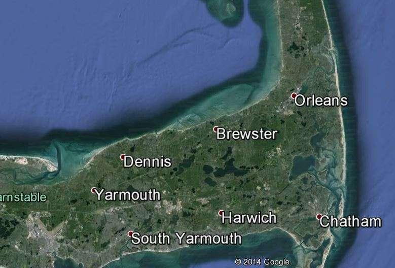
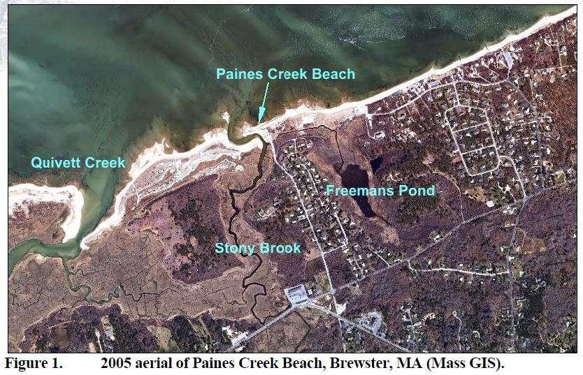
2 Brewster, Massachusetts

3 Almost 1/3 of town preserved as open space, including water department lands and Nickerson State Park. Many shorefront cottages being converted to larger or year round homes.
4 10 public access areas Parking spaces: Crosby 60, Linnell 25, Spruce Hill 12, Ellis 19, Point of Rocks 3 + 8, Breakwater 62, Little Breakwater 6, Saints 38, Mants 44, Paines Creek 15 =292.

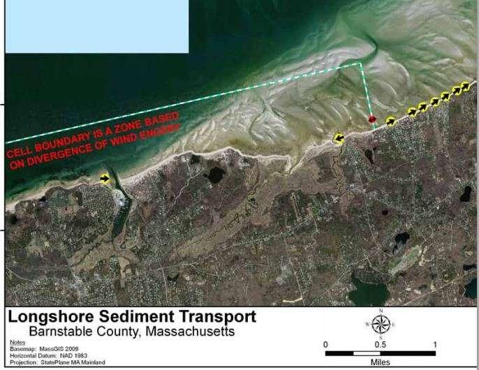
5 The Brewster Flats At low tide there are approximately 12,000 acres of exposed tidal flats extending up to two miles off shore in Brewster.
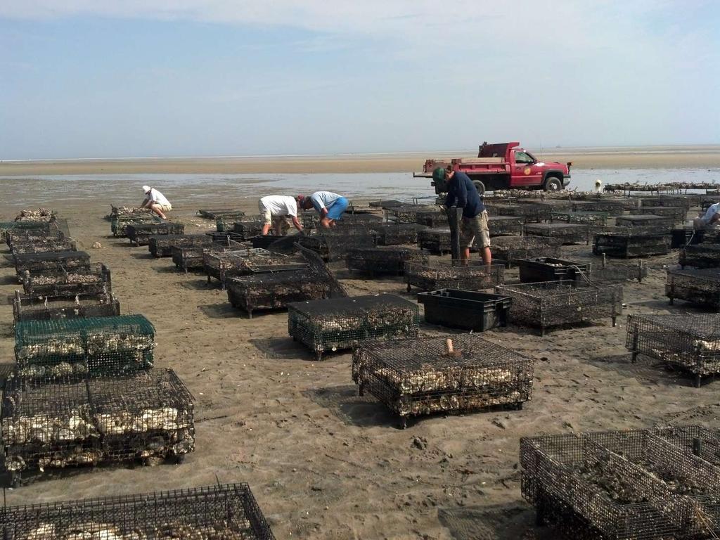
6 Shellfish aquaculture
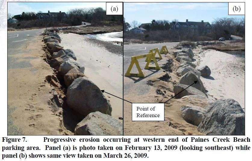
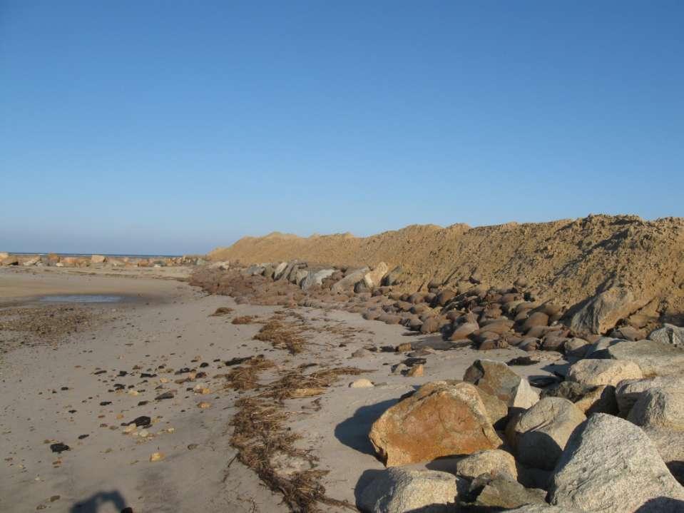
7 Repetitive losses The Problems Erosion rates of up to 2 feet/year (15 in Sandy and related storms) Now, little or no buffer between infrastructure and the beach Loss of parking while increasing demand for access Rising sea level More severe storms, increasing frequency Higher rainfall amounts poor stormwater infrastructure
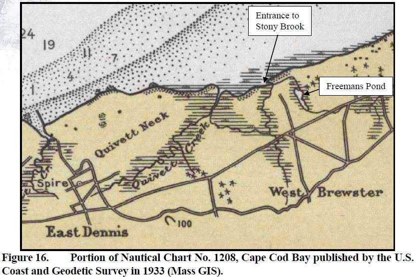
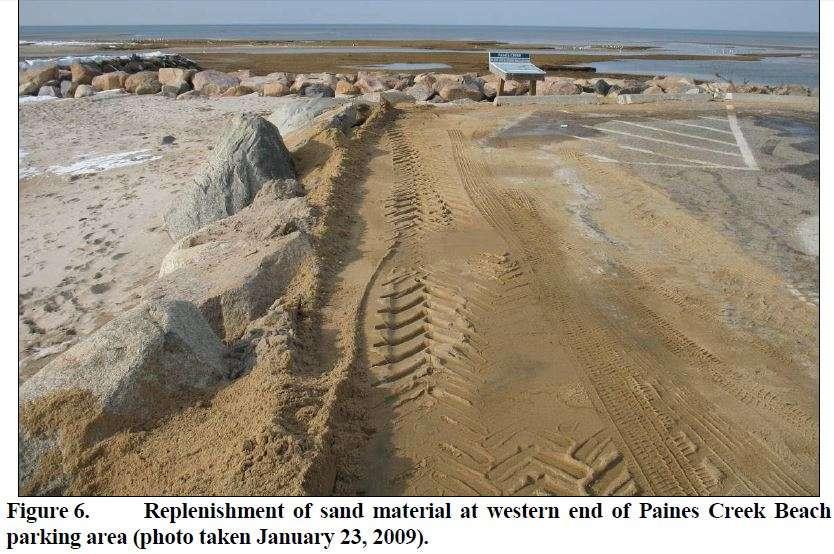
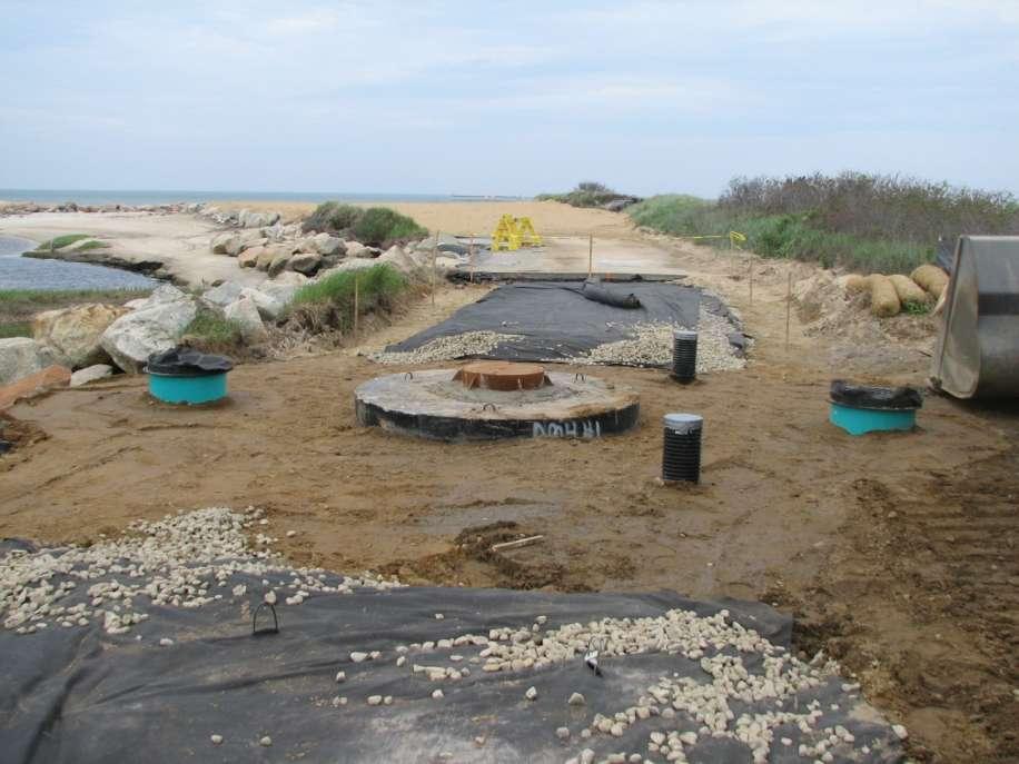
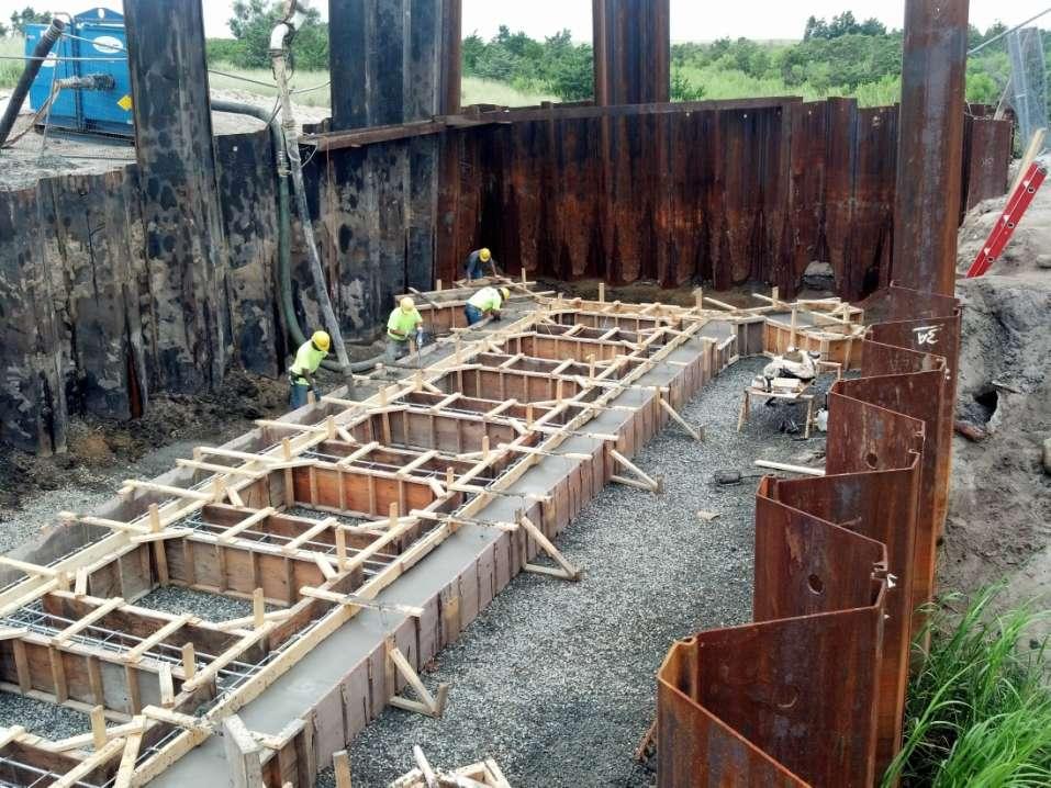
8 Progress to date Purchase of coastal salt marsh and extensive open space Removal/restoration of coastal restrictions Namskaket under bike trail, new culvert in 2007 Quivett Creek culvert under Sea Street in 2006 Rt. 6A culvert at Paines Creek 2009 (ARRA grant) Freemans Pond culvert 2013 Paines Creek parking lot project NRCS, state stormwater grants Watershed approach, protect shellfish beds. From headwater Mill Pond complex to shore at Stony Brook/Paines Creek
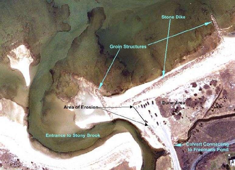
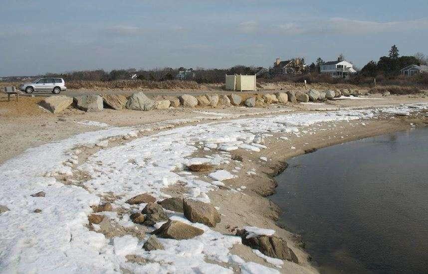
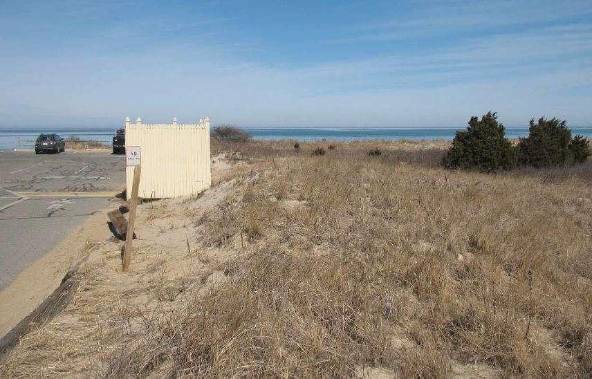
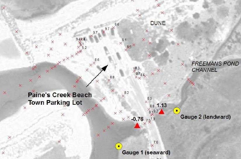
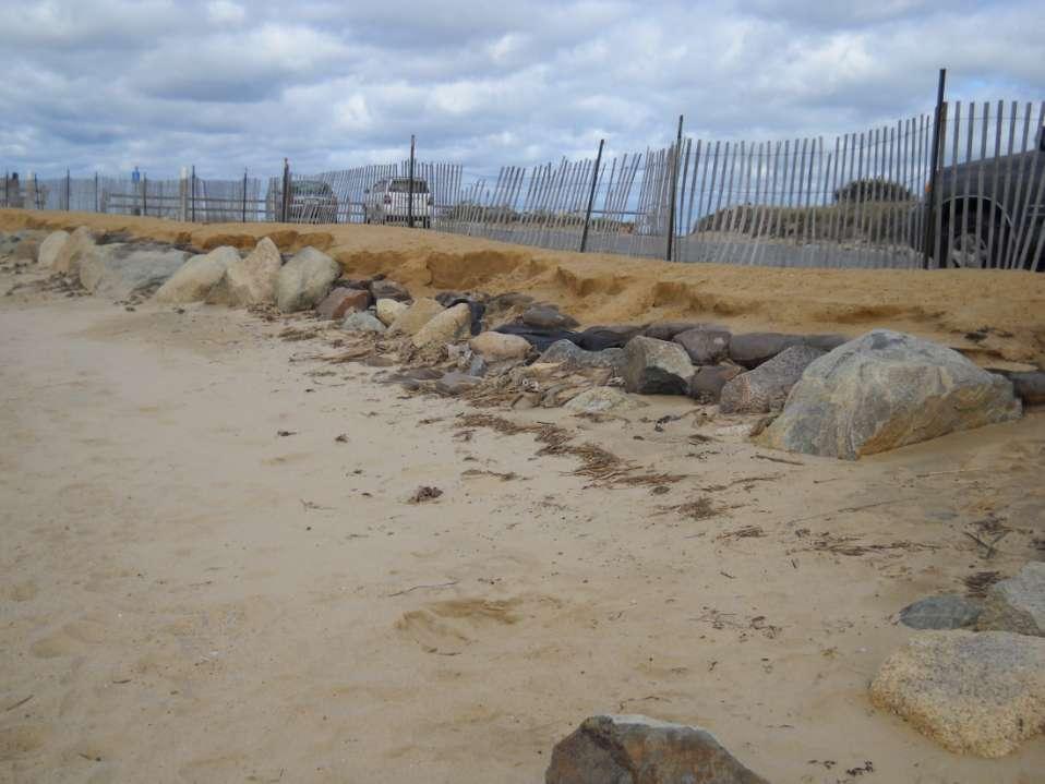
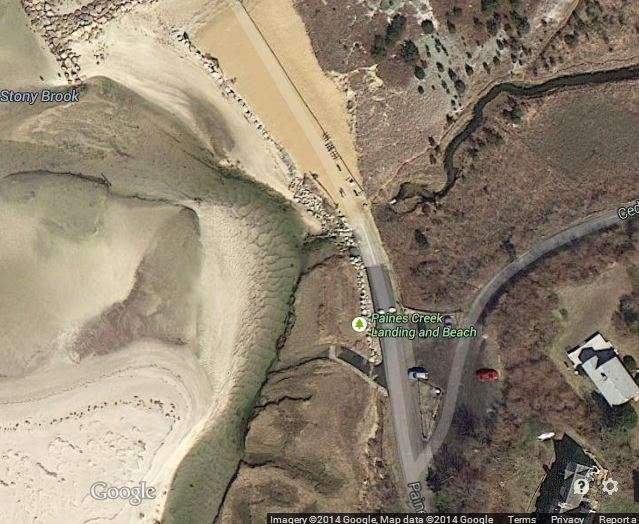
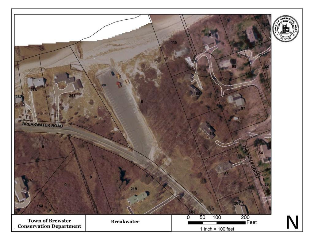
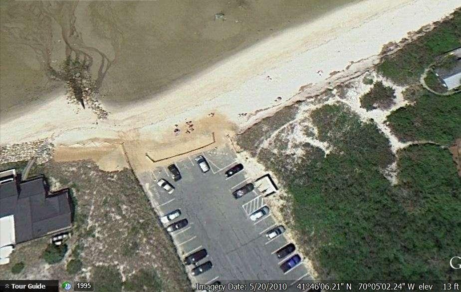
9 Old layout, Paines Creek Landing
10
11
12
13

14
15
16 2009
17
18
19
20

21
22
23
24

25 January 20, 2010
26
27
28

29

30
31
32

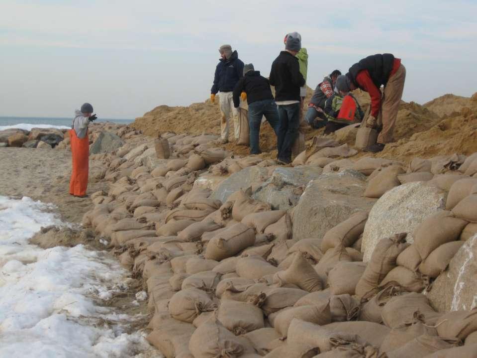
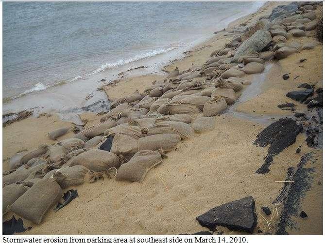
33 March 2010
34
35
36
37
38
39
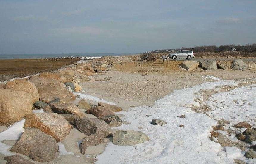
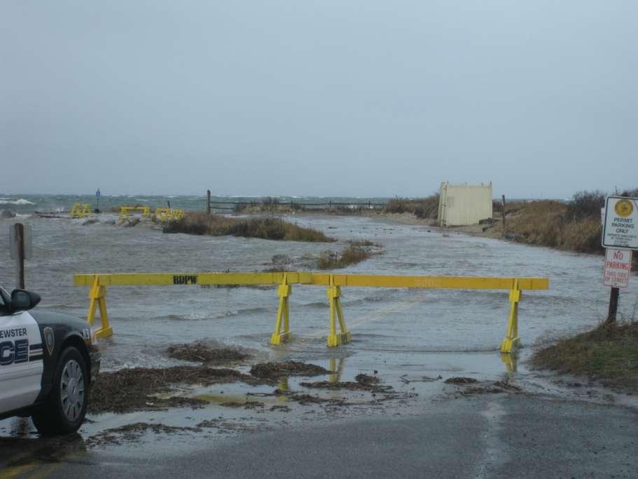
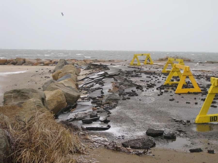
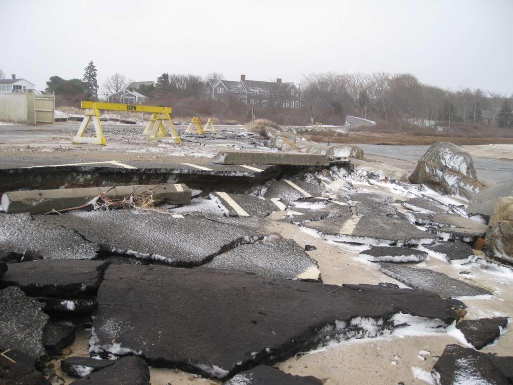
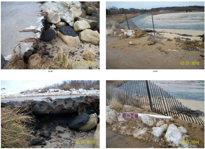
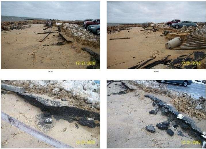
40 2011 Repeat of 2010: extensive damage to parking area, loss of pavement and asphalt fragments throughout beach and creek. AmeriCorp helps install another 1000 sandbags to shore up area. Very short term repair, additional damage in spring.
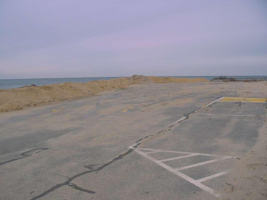
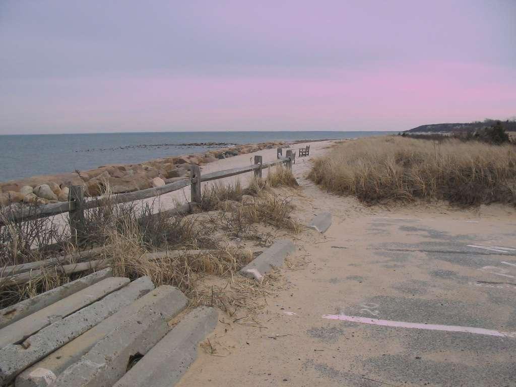
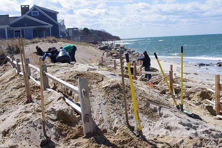
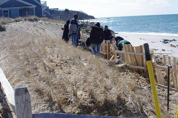
41 NRCS Stormwater Grants Saints Landing Paines Creek Road North Paines Creek Road South, including town landing Instead of capturing and infiltrating stormwater at beach parking lot, we considered the retreat alternative, restoring the dune and building a similar sized lot in the road layout further inland.
42
43 Coastal Retreat Repetitive losses, high cost Environmental damage (asphalt/fill etc.) Long term likelihood of failure with rising seas and increasing storm intensity Hard solution would not be allowed Any permanent wall would result in loss of beach

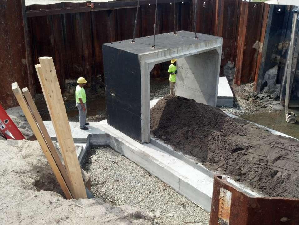
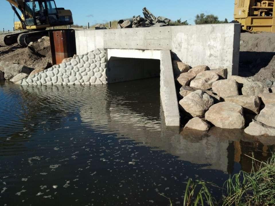
44 Old layout, Paines Creek Landing
45 Stormwater NRCS grant requires 75 year life for structure. Stormwater basins in a dune? Instead, repurpose grant to remove asphalt, restore to natural habitat, reconstruct a smaller and better designed and resilient parking area.
46

47 Winter storm Nemo
48
49
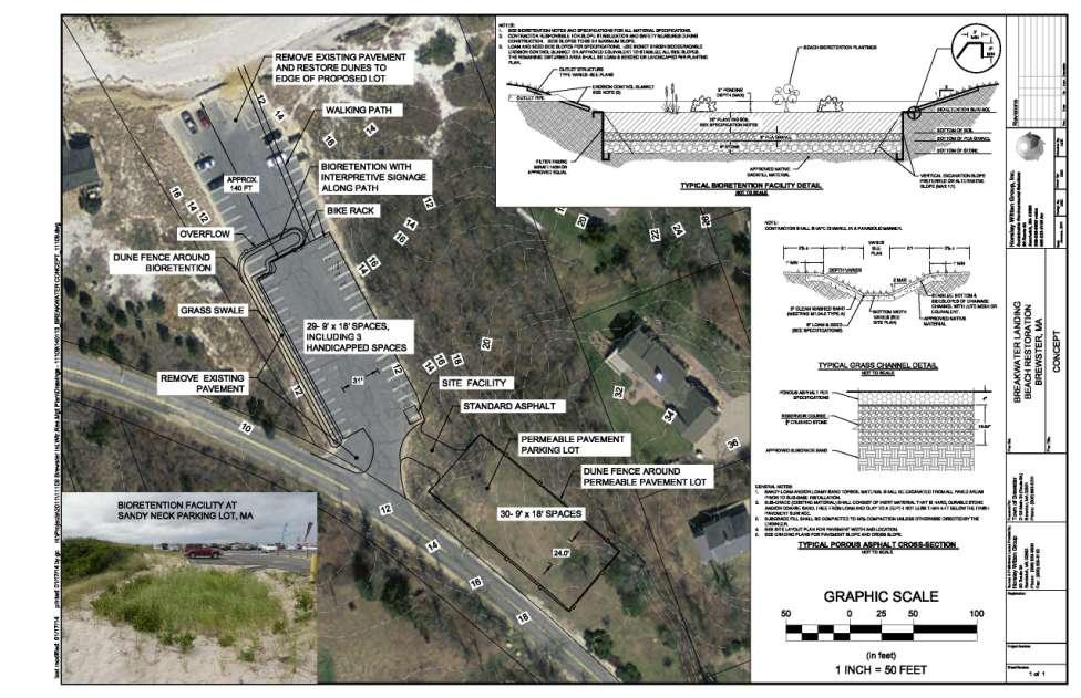
50 Sandy and Nemo Since parking lot retreat, several severe storms. Old parking lot would have likely suffered extensive damage, if not completely destroying it. Restored area lost a lot of beach sand. New parking area inundated but minimal damage.
51 Freemans Pond Culvert
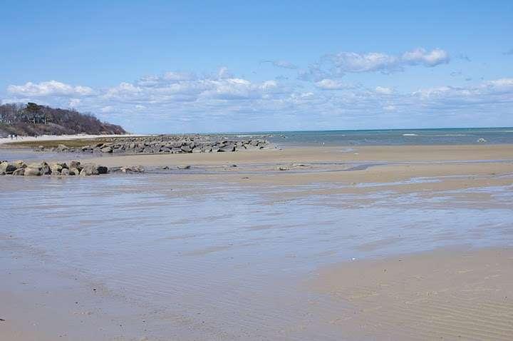
52
53
54
55 COASTAL COMMUNITY RESILIENCE GRANT PROGRAM FY14 Brewster s Coastal Adaptation Project Public education or other communication initiatives; Assessing vulnerability and risk; Identifying and implementing management measures; Redesigning to accommodate changing conditions; and Enhancing natural storm-damage protection. Straight from the CZM Stormsmart Coasts guidance.
56 Coastal Resilience Grant Total Project Cost: $298,925 Match Amount $98,925 (33%) Town & Partner Match ($50,000 cash, $18,000 inkind by Town, $10,000 match in other work by Town, $10,925 In-Kind match by the Association to Preserve Cape Cod (APCC), $10,000 match in grant funds by APCC) Grant Amount Awarded : $200,000
57 Breakwater Beach Resiliency Design Relocation of Breakwater Landing Beach Parking Area, Restoration of Beach and Dune Habitat, Green Stormwater Infrastructure: Outputs: 100% design plans and bidding documents for removal and relocation of the parking lot, restoration of habitat, and improved access paths. Green Infrastructure grant awarded for implementation: $155,000 plus town match of $69,000.
58

59 Breakwater Bath house c.1900
, and")
60 Breakwater Beach Bath Houses c.1900 Some of these bath houses were owned by the town, with the town collecting the rent (in 1930 about $7 for the summer), and some were privately owned. The last bath houses were torn down in 1945 when the property was sold.
61
62
63
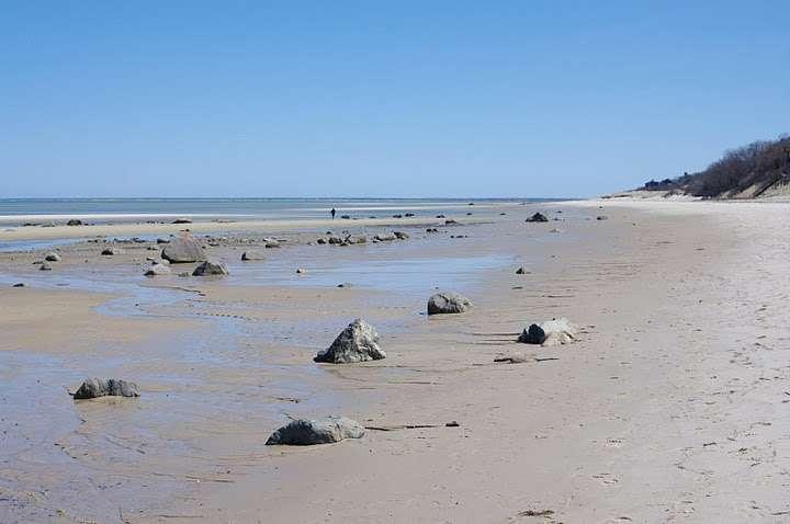
64
65

66 Breakwater March 2010
67 Breakwater May 2010
68 Since 2010 Much larger sacrificial dune supported by sturdy sand fence Beach grass planted on dune to add resiliency Size of dune allows infiltration of stormwater without a blow out through dune or entrance. Neighbor to west improves end of revetment with reinforced coir logs, sand nourishment, sturdy sand fence.


69 Planting beach grass Alternative spring break, Brandeis University
70
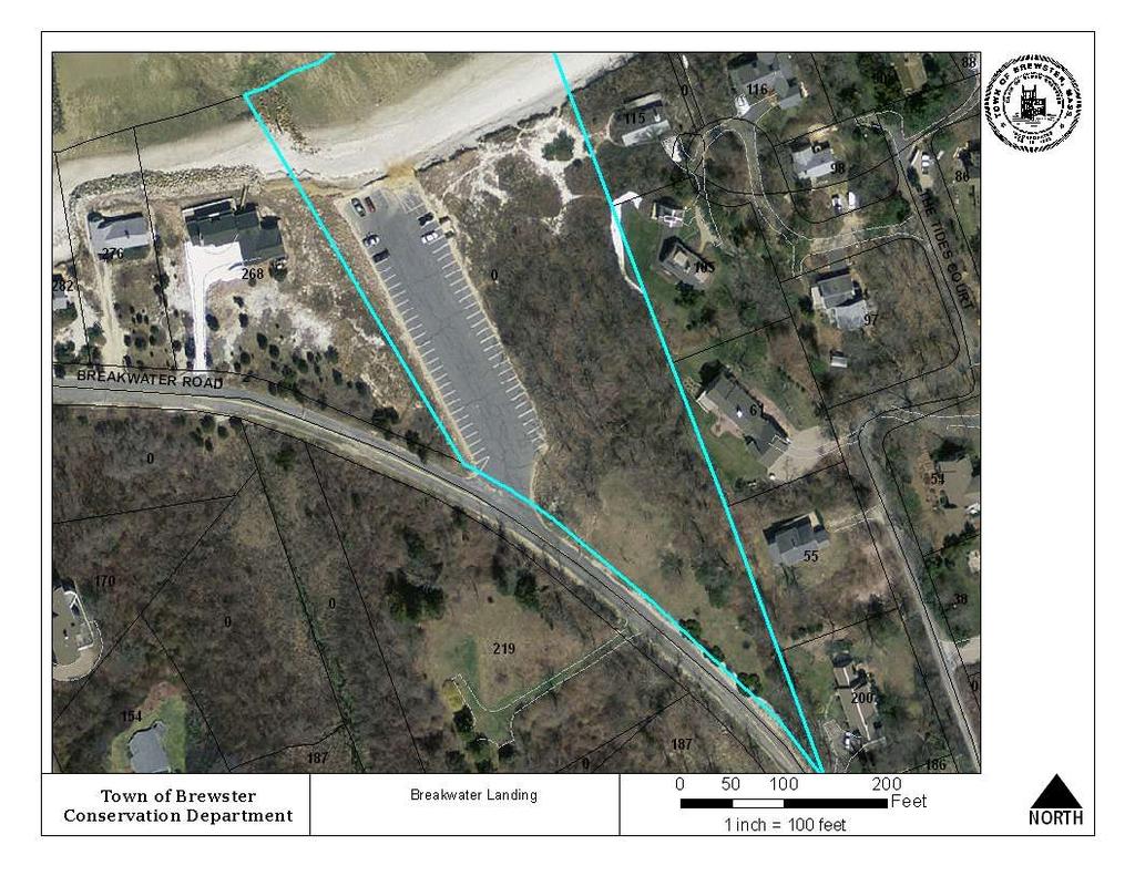
71

72 Breakwater February 2013

73 Breakwater February 2013

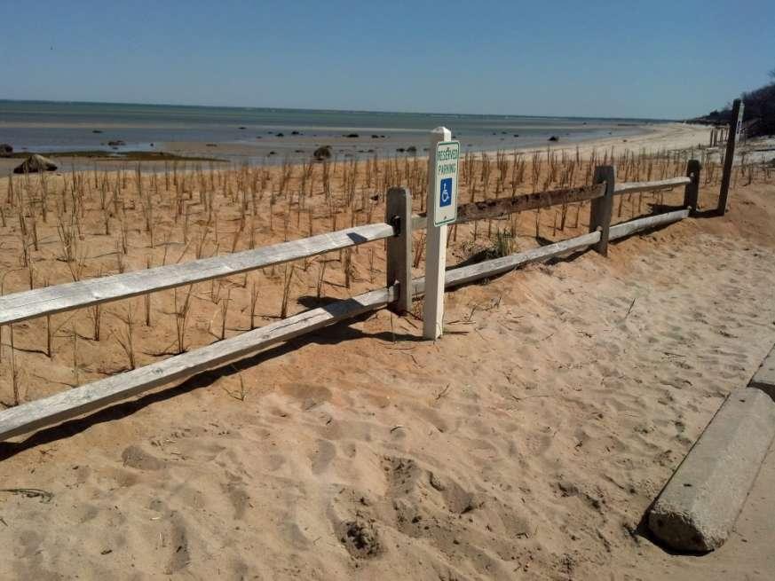
74 Breakwater spring 2013

75 End scour from revetment to west

76 Sturdy sand fence in sacrificial dune at Breakwater

77 Sturdy fence buried under new dune located slightly further from active beach.
78
79 Conceptual Plan

80 Concept: Retreat and rebuild

81 New replacement lot
82 Details Restore area to coastal dune, add beach sand to increase elevation to match surrounding, plant beach grass and shrubs. Articulating concrete mat under sand to allow vehicle traffic access through dunes for emergency response, coastal nourishment projects. Seasonal boardwalk through dunes to beach. Interpretive displays.
WORKSHEET 24: Sand dunes - Conservation and management
 SAND DUNES - CONSERVATION AND MANAGEMENT MEETING THE CHALLENGE Sand dunes are: Excellent natural protection for the land A great recreational and educational area A specialised wildlife habitat But they
Sea Meadow Inn Brewster, Cape Cod, MA
 Offered for Sale by Cape Cod Village Realty InnAdvisors www.ccvre.com - email: inns@ccvre.com Price: $998,000 For details call Carol at 508-237-1617 or Marco at 646-831-1976 Price: $998,000.00 Address:
Ongoing Projects 3/16/2017 2
 Ongoing Projects 26 th to 34 th Street, West Avenue to Bay Avenue ($6.5 million contract awarded) 46 th Street (complete) 29 th Street Firehouse South Jersey Gas improvements 34 th Street playground repairs
Clam Harbour Provincial Park
 Clam Harbour Provincial Park Public Engagement Session Thursday, September 14 th, 2017 5:30pm 7:30pm Webbers Store 11470 Nova Scotia Trunk 7 Lake Charlotte, NS Agenda Overview of the Provincial Parks System
Capital Prioritization
 14 Capital Prioritization 279 279 280 Park & Recreation CAPITAL PRIORITIZATION As described in Chapter 8, the recommendations presented in Chapter 9 are prioritized to provide a guide for future capital
B10. Agate Beach State Recreation Site
 B10. Agate Beach State Recreation Site Location Within the City of Newport, just south of the Yaquina Head Outstanding Natural Area. The park is located along the west side of Highway 101 at the mouth
Draft Length 10 Thorness Bay to Cowes Chain Ferry
 Draft Length 10 Thorness Bay to Cowes Chain Ferry Introduction The southern section of this length of coast is largely (mud and sand) beach edged with landslip. Landward of this is agricultural land with
The reasons why coastal management is needed in Minehead:
 1. Resource 1: Why did Minehead need new sea defences? Coastal management in Minehead In pairs, read the following resource and highlight the reasons why coastal management was needed in Minehead. The
NORTH HEMPSTEAD BEACH PARK MASTER PLAN
 NORTH HEMPSTEAD BEACH PARK MASTER PLAN COMMUNITY DESIGN CHARRETTE Supervisor Judi Bosworth Viviana L. Russell Peter J. Zuckerman Angelo P. Ferrara Anna M. Kaplan Lee R. Seeman Dina M. De Giorgio VISIONING
City of Fort Lauderdale. Frequently Asked Questions. Proposed Sea Wall Ordinance
 City of Fort Lauderdale Frequently Asked Questions Proposed Sea Wall Ordinance The City of Fort Lauderdale is considering amending the Unified Land Development Regulations of the City of Fort Lauderdale
Agenda Report. Spruce Street Outlet Drainage Improvements Tower Road Relief Sewer
 Agenda Report Subject: Prepared By: Spruce Street Outlet Drainage Improvements Tower Road Relief Sewer Steven M. Saunders, Director of Public Works/Village Engineer Date: August 12, 2012 On March 8, 2012
^ox, 7. Environment Agency. Hayling Island North Strategy *. M ^, v. * > -.
 ^ox, 7 Environment Agency Hayling Island North Strategy *. M ^, v. * > -. Consultation Document for Preferred Coastal Defence Options - Septem ber 2005 We are the Environment Agency. It s our job to look
March 2, The Honorable Mayor Williams D. Sessoms, Jr. Members of City Council. Subject: Coastal CIP Presentation to City Council - March 6, 2018
 OFFICE OF THE CITY MANAGER (757) 385-4242 (757) 427-5626 FAX MUNICIPAL CENTER BUILDING 1, ROOM 234 2401 COURTHOUSE DRIVE VIRGINIA BEACH, VA 23456-9001 March 2, 2018 The Honorable Mayor Williams D. Sessoms,
Appendix C. Past and Current Management of Selected Tidal Wetland Sites
 Appendix C. Past and Current Management of Selected Tidal Wetland Sites Maps and photographs of wetland sites can be found at http://www.elkhornslough.org/tidalwetlandproject. Site 1. Parsons Slough/South
Guide to Siting of Seawalls January 13, 2014 by Michael Walther, P.E., D.CE, President - Coastal Tech
 January 13, 2014 by Michael Walther, P.E., D.CE, President - Coastal Tech mwalther@coastaltechcorp.com Prepared for the Sea Turtle Conservancy http://www.conserveturtles.org/ Introduction Overview: This
The Galveston Seawall
 Coastal and Ocean Engineering ENGI.8751 Undergraduate Student Forum Faculty of Engineering and Applied Science, Memorial University, St. John s, NL, Canada. March, 2013 The Galveston Seawall Mark Harvey
TRANSMITTAL. Please contact me with any questions. 7 Spruce Road, Freeport, ME T: (207)
") BAKER DESIGN CONSULTANTS Civil, Marine and Structural Engineering To: Alex Jaegerman FAICP Director of Planning & Development Town of Yarmouth 200 Main Street PO Box 907 Yarmouth, ME 04096 From: Barney
BAKER DESIGN CONSULTANTS Civil, Marine and Structural Engineering To: Alex Jaegerman FAICP Director of Planning & Development Town of Yarmouth 200 Main Street PO Box 907 Yarmouth, ME 04096 From: Barney
Palm Beach County Traffic Report July 13 through July 20, 2012
 For Immediate Release July 13, 2012 Meredith Cruz, (561) 641-6440 mcruz@corradino.com Palm Beach County Traffic Report July 13 through July 20, 2012 Palm Beach County Palm Beach County traffic will be
A Brief History of the Town of Palm Beach Coastal Protection Program. Beach nourishment occurred in Palm Beach as far back as the 1940s.
 A Brief History of the Town of Palm Beach Coastal Protection Program Beach nourishment occurred in Palm Beach as far back as the 1940s. The Lake Worth Inlet Sand Transfer Plant was built in the late 1950s.
PITA. PITA's campaign scores victory for public beach access. Christmas Fair celebrates 20th year. November 2014 INSIDE THIS ISSUE
 November 2014 PITA Sponsored by Plum Island Taxpayers and Associates, Inc. ( PITA ) Bringing Plum Island Together Volume 14, Issue 3 INSIDE THIS ISSUE - PITA S CAMPAIGN SCORES VICTORY OF ACCESS - CHRISTMAS
Status of Mangroves in Belize
 Status of Mangroves in Belize State of the Coastal zone Summit June 7 th 2012 Nadia Bood*, Emil Cherrington and Tim Smith Outline Introduction to mangroves Importance of mangrove to Belize National status
Effects of Sea Level Rise and Storm Surge Events On Cape May County s Tourism and Commerce
 Megan Hajduk Advanced Environmental Geomatics 5-7-09 Effects of Sea Level Rise and Storm Surge Events On Cape May County s Tourism and Commerce One of New Jersey s most productive resources and vital tourist
Kirkcaldy Sea Wall Improvements. Non-technical Summary. For illustration purposes only to give an indicative representation of the scheme.
 ENVIRONMENTAL STATEMENT Non-technical Summary For illustration purposes only to give an indicative representation of the scheme. Kirkcaldy Sea Wall Improvements Introduction A concrete sea wall fronts
Satoquo SEINO (Graduate School of Engineering, Kyushu University, Japan)
") A reconsideration of horseshoe crab conservation methodology in Japan over the last 100 years and prospects for a marine protected area network in Asian seas Satoquo SEINO (Graduate School of Engineering,
A reconsideration of horseshoe crab conservation methodology in Japan over the last 100 years and prospects for a marine protected area network in Asian seas Satoquo SEINO (Graduate School of Engineering,
Welcome KROSNO CREEK DIVERSION PROJECT CLASS ENVIRONMENTAL ASSESSMENT
 Welcome KROSNO CREEK DIVERSION PROJECT PUBLIC INFORMATION CENTRE # 1 Tonight s Presentation Study Overview Background Existing Conditions Alternative Solutions Preliminary Preferred Solution Next Steps
Intense Hurricane Strike Reconstruction, Vieques, Puerto Rico
 Intense Hurricane Strike Reconstruction, Vieques, Puerto Rico beach vegetated barrier Caribbean Sea N Vieques, Puerto Rico 200 m b) a) 67ºW 65ºW 1989 1956 18.5ºN 1928 PRP12 headland La Parguera 17.5ºN
proof Northwest District
 1 Northwest District The Northwest Florida Water Management District is the most rural of all five water management districts. From just east of Tallahassee west to the Florida/Alabama line, and from the
2. Goals and Policies. The following are the adopted Parks and Trails Goals for Stillwater Township:
 D. PARKS AND TRAILS 1. Introduction Stillwater Township s population is relatively low, with most residents living on rural residences on large lots. The need for active park space has been minimal in
TRAILS WHERE TO FIND TRAILS IN NOVA SCOTIA
 TRAILs SIGNAGE Know the Signs............................ 44 WHERE YOU CAN RIDE Roads and Highways........................ 46 Designated Trails........................... 47 Established Trails...........................
Coastal Impact on barrier Islands: Application to Praia de Faro
 Coastal Impact on barrier Islands: Application to Praia de Faro Theocharis Plomaritis, Oscar Ferreira and Susana Costas RISCKIT Final Meeting This project has received funding from the European Union s
October 7, 2016 Hurricane Matthew Rakes the East Coast of Flagler County for 18.1 Miles
 October 7, 2016 Hurricane Matthew Rakes the East Coast of Flagler County for 18.1 Miles Hammock Dunes Suffers Penetration of the Ocean into the Community; has a 15-30 ft. Wide Triangular Section of the
SEA LEVEL RISE IN THE FLORIDA KEYS
 SEA LEVEL RISE IN THE FLORIDA KEYS SUSTAINABILITY AND CLIMATE MILESTONES YEAR 2014 GreenKeys! Launched YEAR 2015 SLR Data collection SLR modeling for 2030 and 2060 Community SLR Modeling Community Outreach
RIO VISTA MUNICIPAL AIRPORT
 DRAINAGE TECHNICAL MEMORANDUM RIO VISTA MUNICIPAL AIRPORT RIO VISTA, CALIFORNIA Prepared for: City of Rio Vista 1 Main Street Rio Vista, CA 94571 (707) 374-5337 Prepared by: August 2012 Copyright 2012
5 proposed wetland sites
 PROPOSED WETLAND SITES OF VIETNAM Hoang Van Thang, PhD. 5 proposed wetland sites 1. Lak Lake 2. Lo Go Sa Mat 3. Tram Chim 4. UMi Minh hthuong 5. Mui Ca Mau Lak Lake Coordinates: 12o24 22 12o26 25 N 108o09
Executive Summary of Urgent Field Survey of Earthquake and Tsunami Disasters by the 2011 off the Pacific coast of Tohoku Earthquake
 March 25, 2011 Executive Summary of Urgent Field Survey of Earthquake and Tsunami Disasters by the 2011 off the Pacific coast of Tohoku Earthquake Port and Airport Research Institute (PARI) has accomplished
White Mountain National Forest. Campton Day Use Area Development Project. Scoping Report. Prepared by the Pemigewasset Ranger District May 2013
 White Mountain National Forest Campton Day Use Area Development Project United States Department of Agriculture Forest Service Eastern Region Towns of Thornton and Campton, Grafton County, NH Scoping Report
Former Middle School Site Green Space & Brecksville Road Streetscape. March 27, 2018
 Former Middle School Site Green Space & Brecksville Road Streetscape March 27, 2018 Brecksville Streetscape & Downtown Greenspace Project Schedule City of Indepenence 2017 2018 Meeting Schedule Tasks/Deliverables
Region 1 Piney Woods
 Region 1 Piney Woods Piney Woods 1. This ecoregion is found in East Texas. 2. Climate: average annual rainfall of 36 to 50 inches is fairly uniformly distributed throughout the year, and humidity and temperatures
DRAFT GENERAL IMPLEMENTATION PLAN AND SPECIFIC IMPLEMENTATION PLAN MIDDLETON MUNICIPAL AIRPORT MOREY FIELD. Revised 12/12/03
 DRAFT GENERAL IMPLEMENTATION PLAN AND SPECIFIC IMPLEMENTATION PLAN MIDDLETON MUNICIPAL AIRPORT MOREY FIELD Revised 12/12/03 As recommended for approval by the Plan Commission General Project Description
Minutes of the June 2 meeting were approved unanimously on a motion by Konrad, seconded by Patricia.
 Minutes, Brewster Ponds Coalition, July 7. 2016 Board Members Present: Tom Vautin, John Keith, Dawn Walnut, Patricia Monahan, Konrad Schultz, Gwen Pelletier, Karen Malkus Benjamin. Communications Committee
Bronx Greenway Feasibility Study Volume 2. March 29, 2018
 Bronx Greenway Feasibility Study Volume 2 March 29, 2018 Table of Contents Introduction................................................ 1 Section 1: Opportunities and Challenges Assessment 1.0 Opportunities
Project Management, Environmental Assessment, Stormwater Management. Hydrologic Modelling. Natural Heritage. Fluvial Geomorphology
 Welcome PUBLIC INFORMATION CENTRE # 1 KROSNO CREEK DIVERSION PROJECT February 19, 2014 6:30 p.m. to 8:30 p.m. Please sign in on the sheet provided. Then feel free to walk around and view the displays.
MORGAN CREEK GREENWAY Final Report APPENDICES
 APPENDICES MORGAN CREEK GREENWAY Appendix A Photos of Existing Conditions in Trail Corridor Photos of existing conditions Main trail corridor - February 2009 Photos of existing conditions south bank Morgan
Chapter 4.0 Alternatives Analysis
 Chapter 4.0 Alternatives Analysis Chapter 1 accumulated the baseline of existing airport data, Chapter 2 presented the outlook for the future in terms of operational activity, Chapter 3 defined the facilities
LANDING S PARK CONCEPTUAL PLAN HAMILTON ANDERSON JANUARY City of Novi, Michigan. The Park at 13 Mile and Old Novi Road
 HAMILTON ANDERSON JANUARY 2012 LANDING S PARK CONCEPTUAL PLAN January 2012 Page 1 of 15 January 2012 PROJECT GOALS Activate the park by introducing new elements Provide clear access to the water and enhance
Elkhorn Slough Tidal Wetland Project
 Elkhorn Slough Tidal Wetland Project Joint Meeting Strategic Planning Team and Science Panel September 23, 2009 Funding National Oceanic and Atmospheric Admin. David and Lucille Packard Foundation Resources
Physical. and. Human-made. Features
 Directions for Making a Geographic Features Vocabulary Book 1. Cut the photographs boxes out of page 2 and sort the them into two groups: physical features and human-made features. 2. Correctly match each
2. STAKEHOLDER FEEDBACK // What We Heard
 1. QUARRY ROAD TRAIL // Welcome to the Information Session PROJECT DESCRIPTION WHY WE ARE HERE Quarry Road Trail is a popular commuter trail and recreational area for Calgarians. 1. To report citizen feedback
MANAGING COASTAL HAZARDS THROUGH BENEFICIAL REUSE OF DREDGED SAND AND AN ADAPTIVE WORKS STRATEGY
 MANAGING COASTAL HAZARDS THROUGH BENEFICIAL REUSE OF DREDGED SAND AND AN ADAPTIVE WORKS STRATEGY Isabelle Ghetti 1, B.Morgan 2, R.Massie 1, Gary Blumberg 2 1 Shoalhaven City Council, Nowra, NSW 2 Royal
Community Services Associates, Inc. (CSA) Maintenance, Enhancements and Major Projects Committee March 1 st, 2018
 Maintenance, Enhancements and Major Projects Committee March 1 st, 2018") Community Services Associates, Inc. (CSA) Maintenance, Enhancements and Major Projects Committee March 1 st, 2018 On Thursday, March 1 st 2018, a regular meeting of the Maintenance, Enhancements and Major
Community Services Associates, Inc. (CSA) Maintenance, Enhancements and Major Projects Committee March 1 st, 2018 On Thursday, March 1 st 2018, a regular meeting of the Maintenance, Enhancements and Major
= Stops. = Restrooms
 = Stops = Restrooms Restrooms are located near the Lake Elkhorn pavilion Safety Tips 1.Be courteous. 2.Travel at a safe speed. 3.Use your bell or announce: passing on your left. 4.Remember there are people
The mission of Liberty State Park is to provide the public with access to the harbor s resources, a sense of its history and a charge of
 Liberty State Park The mission of Liberty State Park is to provide the public with access to the harbor s resources, a sense of its history and a charge of responsibility to its continued improvement.
Lake Myra County Park. Wake County, North Carolina Community Forum #2 June 12, 2008
 Lake Myra County Park Wake County, North Carolina Community Forum #2 June 12, 2008 Welcome and Introduction Meeting Agenda Welcome Introductions of Project Team Master Plan Process Community Forum #1 Updates
Hollaway Consulting Engineers, LLC Statement of Qualifications
 Deliberate, Strategic, Connected.Delivering tangible solutions for aviation design and construction management. Hollaway Consulting Engineers, LLC Statement of Qualifications Professional Experience Sheri
NEWBORO AND PORTLAND HARBOUR REDVELOPMENT PLANS
 INTRODUCTION The Municipal docks in both Newboro and Portland were transferred to the Township of Rideau Lakes by Parks Canada in 2002. Little has been done to improve the docks physical condition or role
URBAN DESIGN REPORT. Proposed Residential Development, Old Church Road, Caledon East
 Proposed Residential Development, Old Church Road, Caledon East TABLE CONTENTS: 1.0 DEVELOPMENT 1.1 Introduction-Analysis of Guiding Principles and Documents 1.2 Community Design and Architectural Design
Conservation Area Management Statement
 Conservation Area Management Statement Miller Creek Wildlife Area Resolution #: Approval: Issue Date: Date of Last Revision: Table of Contents 1. Purpose....... 1 2. Property Description...... 1 2.1. Legal
MASTER PLAN EXECUTIVE SUMMARY
 Biscuit Run State Park Scottsville Road (State Route 20) Charlottesville, VA 22902 Biscuit Run State Park MASTER PLAN EXECUTIVE SUMMARY Department of Conservation and Recreation Division of Planning and
e 2 design season three New Orleans: The Water Line Episode Summary
 e 2 design season three New Orleans: The Water Line Episode Summary After the devastation of Hurricane Katrina, which hit the southern coast of the United States on August 28, 2005, the residents of the
STORNETTA BROTHERS COASTAL RANCH
 STORNETTA BROTHERS COASTAL RANCH Location: Surrounding Point Arena Lighthouse and immediately south of Manchester State Park Mendocino Co., CA Acres: 1,860 Resources: Over two miles of Pacific Ocean coastline
NATURAL RESOURCES & RECREATION
 INTRODUCTION The Lemon Creek Area has abundant natural resources, including five salmon streams, an impressive range of intertidal and freshwater wetland habitats, and unique old growth forest. Lemon Creek
River First Initiative and Waterworks Park
 River First Initiative and Waterworks Park The RiverFIRST proposal is critical to the creation of a larger regional parks and trails network, as well as ecological and infrastructure system. When realized,
ARLINGTON COUNTY, VIRGINIA
 ARLINGTON COUNTY, VIRGINIA County Board Agenda Item Meeting of June 18, 2016 DATE: May 5, 2016 SUBJECT: Award of construction contract under ITB No. 16-240-ITB for the reconstruction of the playground,
Budi Hadi Narendra Harris Herman Siringoringo Chairil Anwar Siregar. Research and Development Center for Forest
 Budi Hadi Narendra Harris Herman Siringoringo Chairil Anwar Siregar Research and Development Center for Forest Background Coastal management should be wisely done as a part of watershed management. Typologically,
Auburn Trail / Ontario Pathways Trail Connector Feasibility Study Public Information Meeting Wednesday, August 22, 2012
 Auburn Trail / Ontario Pathways Trail Connector Feasibility Study Public Information Meeting Wednesday, August 22, 2012 Purpose of Feasibility Study Purpose Evaluate the feasibility of constructing a multiuse
Plaza del Rio. Rio Grande Sanctuary. Exclusive Home Sites in the San Luis Valley, Colorado
 Plaza del Rio Rio Grande Sanctuary Photography by Gary Tyson River Valley Group, LLC and Team Murphy Realty, LLC offer for sale: Exclusive Home Sites in the San Luis Valley, Colorado Plaza del Rio Exclusive
Conservation of Critical Environmental Resources in Chatham Park
 Conservation of Critical Environmental Resources in Chatham Park Elaine Chiosso, Haw Riverkeeper Haw River Assembly Haw River As Seen From Chatham Park "Spreading southwestward from the banks of the Haw
What Is An Ecoregion?
 Ecoregions of Texas What Is An Ecoregion? Ecoregion a major ecosystem with distinctive geography, characteristic plants and animals, and ecosystems that receives uniform solar radiation and moisture Sometimes
Impact of Offshore Directed Forcing on Sediment Transport and Structural Integrity at Packery Channel, Corpus Christi Texas
 Google Earth 29 Aug 2017 Impact of Offshore Directed Forcing on Sediment Transport and Structural Integrity at Packery Channel, Corpus Christi Texas Deidre D. Williams Coastal Research Scientist Conrad
Planning Commission Meeting Minutes Thursday, January 22, 2009 City Council Chambers 220 East Morris Avenue Time: 7:00 p.m.
 Planning Commission Meeting Minutes Thursday, January 22, 2009 City Council Chambers 220 East Morris Avenue Time: 7:00 p.m. Commission Members Present: Francis Lilly- Conducting Lloyd Anderson Joshua Smith
% farmers/private landowners in watershed applying BMPs. Other (Number of participants completed the training)
") Easygrants ID: 23803 National Fish and Wildlife Foundation NFWF/Legacy Grant Project ID: 0302.10.023803 U. S. Coral Reef Task Force Partnership Initiative 2010 - Submit Final Programmatic Report (Activities
Easygrants ID: 23803 National Fish and Wildlife Foundation NFWF/Legacy Grant Project ID: 0302.10.023803 U. S. Coral Reef Task Force Partnership Initiative 2010 - Submit Final Programmatic Report (Activities
Capital Five-Year Fiscal Forecast
 Capital Five-Year Fiscal Forecast Budget Forecast Forecast Forecast Forecast REVENUES 2016-2017 2017-2018 2018-2019 2019-2020 2020-2021 State sources: CO&DS distributed to district $ 310,000 $ 310,000
COMMUNITY MEETING NOVEMBER 1, Wheaton Regional Park Pine Lake Trail
 COMMUNITY MEETING NOVEMBER 1, 2012 MEETING AGENDA I. Introduction of Project Team II. Trail Renovation Process III. Wheaton Regional Park IV. Pine Lake Trail Renovation Project V. Comments and Questions
Whittier Bridge Project
 Amesbury / Newburyport / Salisbury Whittier Bridge / I-95 Improvement Project Original Whittier Bridge Proposed Whittier Bridges 10/21/2016 Whittier Bridge Project 1 Project Description The project limits
KNOWLEDGE NOTE 1-3. Hydro-meteorological Disasters Associated with Tsunamis and Earthquakes. CLUSTER 1: Structural Measures
 Public Disclosure Authorized Public Disclosure Authorized Public Disclosure Authorized Public Disclosure Authorized KNOWLEDGE NOTE 1-3 CLUSTER 1: Structural Measures Hydro-meteorological Disasters Associated
Florida Department of Environmental Protection Division of Recreation and Parks
 Florida Department of Environmental Protection Division of Recreation and Parks Land Honeymoon Island State Park Introduction Honeymoon Island State Park is a 2,810.16-acre public outdoor recreation and
ADDENDUM NO. TWO AB
 ADDENDUM NO. TWO AB2018-28 Notice is hereby given that on June 22, 2018 at 11:00 A.M. (Prevailing time), sealed bids will be opened and read in public by the Purchasing Department in the Mercer County
Site description: 2.7 miles of intertidal habitat located about 2 miles north of Depoe Bay in Lincoln County, Oregon (Figure 16).
.") 8 Boiler Bay Site description: 27 miles of intertidal habitat located about 2 miles north of Depoe Bay in Lincoln County, Oregon (Figure 16) Designation: Boiler Bay was a research reserve before TSP publication,
8 Boiler Bay Site description: 27 miles of intertidal habitat located about 2 miles north of Depoe Bay in Lincoln County, Oregon (Figure 16) Designation: Boiler Bay was a research reserve before TSP publication,
Coastal Structures in Kagoshima Coastline, Japan Ejria Binti Saleh Universiti Malaysia Sabah, Sabah, Malaysia
 Coastal Structures in Kagoshima Coastline, Japan Ejria Binti Saleh Universiti Malaysia Sabah, Sabah, Malaysia Report for International Training Program to improve the study ability in biodiversity 1 1.0
Chapter 10. Damage to Ports and Coastal Facilities
 Chapter 10 Damage to Ports and Coastal Facilities 10.1 Area Investigated Tsunami induced heavy damage to ports and coastal facilities along the west and north coast of Sumatra Island. Figure 10.1 shows
2013 Construction Accomplishments
 2013 Construction Accomplishments MOA Parks & Recreation Key Accomplishments in 2013 1. Over 10 Million Dollars in MOA Park Improvements 2. A Successful Volunteer Program with over 9,000 Volunteer Hours
MOSE PROJECT: STATE-OF-THE-ART AND FUTURE DEVELOPMENT
 AIPCN-France Third Mediterranean Days of Coastal and Harbour Engineering Troisièmes journées méditerranéennes de génie côtier et portuaire 23/05/2013 Marseille MOSE PROJECT: STATE-OF-THE-ART AND FUTURE
Public Service Department MONTHLY REPORT November 2017
 - Public Service Department MONTHLY REPORT Professionalism Integrity Be inspired. Reliability Quality Pride Inside This Issue: Department Highlights 2 Project Planning Updates 3 City Construction Projects
Sibley LUPA. Board Executive Committee Meeting December 7, 2017
 Sibley LUPA Board Executive Committee Meeting December 7, 2017 Project Location & Project Area 1,318-acre Robert Sibley Volcanic Regional Preserve Project Area Purpose Project Purpose & Goals Append the
HARBOR INFRASTRUCTURE INVENTORIES Buffalo Harbor, New York
 HARBOR INFRASTRUCTURE INVENTORIES Buffalo Harbor, New York Harbor Location: Buffalo Harbor is located on the Eastern shore of Lake Erie in the City of Buffalo, NY. Authority: River & Harbor Acts of 1826,
The Use of Low Cost Breakwaters for Mangrove Restoration in Muddy Foreshores
 The Use of Low Cost Breakwaters for Mangrove Restoration in Muddy Foreshores Douglas A. Gaffney, P.E. Ranata Robertson October 23, 2012 The Use of Low Cost Breakwaters for Mangrove Restoration in Muddy
MINUTES OF MEETING OF WAREHAM CONSERVATION COMMISSION
 MINUTES OF MEETING OF WAREHAM CONSERVATION COMMISSION Date of Meeting: January 3, 2018 I. CALL MEETING TO ORDER The meeting was called to order at 7:02 P.M. II. ROLL CALL Members Present: Members Absent:
UMASS CROSS-COUNTRY Trails
 UMASS CROSS-COUNTRY Trails 1) EGG (43 min) (A) From Cage proceed to North Pleasant street (by campus pond). Make left and head toward LGRT and pass School of Education. Pass Puffton Apt complex (on left)
STRATEGIES FOR PROTECTING YOUR PROPERTY
 STRATEGIES FOR PROTECTING YOUR PROPERTY A Homeowner s Guide for Flood, Debris, and Erosion Control after the High Park Fire (Includes tips on how to properly use sandbags) Larimer County Engineering Department
Capital Planning City of Ocean City 1
 City of Ocean City Capital Planning 2015-2019 City of Ocean City 1 Road Improvements Project Completion Date 2012 Fall Road Improvement Spring, 2014 Program - (Paving 7 th Street, 8 th Street, 800 Block
2015 Bond Proposal Model Airplane Parks (PR96) Alternative Model Airplane Park Location
 Alternative Model Airplane Park Location") Our club, Green Valley R/C Flyers, is presenting this proposal for consideration as an alternative location for a Model Airplane Park to be included in PR96 for the 2015 Bond Election. We are recommending
Our club, Green Valley R/C Flyers, is presenting this proposal for consideration as an alternative location for a Model Airplane Park to be included in PR96 for the 2015 Bond Election. We are recommending
IRONTON-RUSSELL BRIDGE REPLACEMENT
 IRONTON-RUSSELL BRIDGE REPLACEMENT 2012-2016 District 9 Ohio Department of Transportation Ironton-Russell Bridge Replacement Existing Ironton-Russell Bridge Ironton-Russell Bridge Replacement Existing
Taylor Creek Park Management Plan Online Engagement - Summary
 Objectives of Online Engagement Taylor Creek Park Management Plan Online Engagement - Summary Spread awareness of the creation of the Taylor Creek Park Management Plan. Provide an overview of the project.
Northern Rail Extension, Phase One
 General Project and Funding 1. Where does Phase One start? The rail line for Phase One begins roughly at the northern boundary of the former Bradbury property, but also includes work along Tom Bear Trail
155 acres on Tyaughton Lake 900 feet of Pristine Waterfront Private & Secluded Property
 155 acres on Tyaughton Lake 900 feet of Pristine Waterfront Private & Secluded Property 946 Tyaughton Lake Road Gold Bridge BC V0K1P0 900 ft of waterfront with 155 acres of south facing easy access. This
14 C.F.R. Part 158. Passenger Facility Charge Program Logan International Airport. Public Notice
 14 C.F.R. Part 158 Passenger Facility Charge Program Logan International Airport Public Notice Summary of Proposed 2018 PFC Application PFC Project Descriptions and Justifications PFC Financial Plan Class
Proposed Cherry Grove Canals Dredging Project
 Proposed Cherry Grove Canals Dredging Project 1 Development of Cherry Grove C.D. Nixon inherited 9,940 acres of land 1924 Nixon family began planning subdivision of Cherry Grove 1950 Mr. Nixon closed natural
Porter Fk. #1. All unauthorized items removed as per FS & Rec Res guidelines. Footbridge may be needed for wheel chair access and for safety
 APPENDIX D Lot Specific Permit Compliance & Forest Plan (FP) Requirements Porter Fork Recreation Residence Tract (Items noted were documented in compliance letter, 8/12/2005, sent to all Rec. Residence
Ditch flows slowly to the north
 Ditch flows slowly to the north Photo 1. Wetland DE: Looking west across Wetland DE from upslope. Ponded water, mucky mineral soils, and patches of emergent vegetation observed. Wetland DE appears to be
Dawlish & South West rail
 Dawlish & South West rail restoring the railway 19 February 2014 1 Dawlish storm 5 February Dawlish sea wall breached on 5 th Feb the most destruction caused since Victorian times 19 February 2014 2 Dawlish