What Is An Ecoregion?
|
|
|
- Katrina Tyler
- 6 years ago
- Views:
Transcription
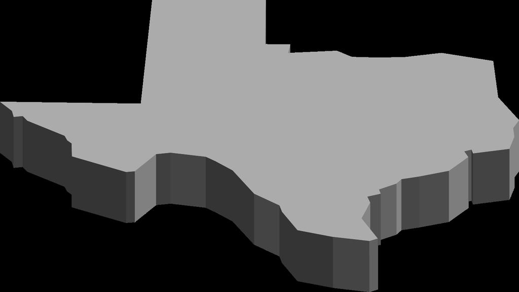
1 Ecoregions of Texas
2 What Is An Ecoregion? Ecoregion a major ecosystem with distinctive geography, characteristic plants and animals, and ecosystems that receives uniform solar radiation and moisture Sometimes called an ecological region or bioregion Smaller than a biome
3
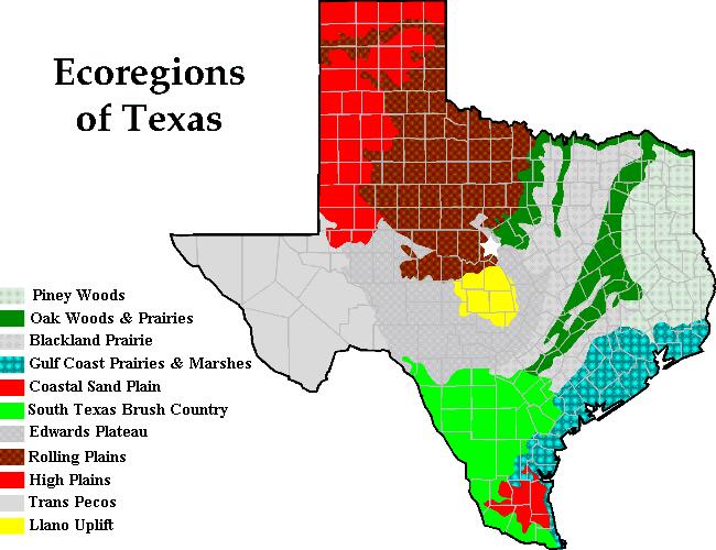
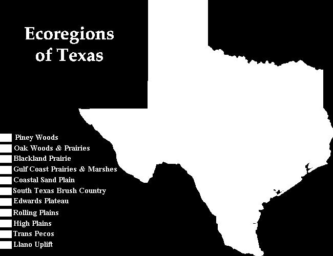
4 Where Are They? Region 1: Pineywoods Region 2: Cross Timbers or Oak Woods and Prairies Region 3: Blackland Prairies Region 4: Gulf Coast Prairies and Marshes Region 5: Coastal Sand Plains Region 6: South Texas Brush Country
5 Where Are They? (cont.) Region 7: Edwards Plateau Region 8: Llano Uplift Region 9: Rolling Plains Region 10: High Plains Region 11: Trans Pecos Region 12: Marine Environment
6 Region 1 Piney Woods Climate: The average annual rainfall is 36 to 50 inches; the humidity and temperatures are typically high. Soil: Largely acidic and typically pale to dark gray sands or sandy loams Elevation: Ranges from 200 to 500 feet above sea level Geography: Rolling terrain Vegetation: Pine and oak; tall hardwood forests; areas of cropland, planted pastures, native pastures, and rich bottomlands
7 Region 2 Cross Timbers or Oak Woods & Prairies Climate: Average annual rainfall 28 to 40 inches per year. Soil: Upland soils tend to be light colored, acidic sandy loam or sands. Bottomland soils tend to be light brown to dark gray and acidic ranging from sandy loams to clays. Elevation: Ranges from 300 to 800 feet above sea level Geography: Gently rolling to hilly terrain Vegetation: Oak savannah; patches of oak woodland alternate with grassland
8 Region 3 Blackland Prairies Climate: The average annual rainfall is from 28 to 40 inches. The northern end of the region has its peak rainfall during the month of May. Rainfall is fairly uniform over the south-central region throughout the year. Soil: Uniformly dark-colored alkaline clays interspersed with some gray acidic sandy loams Elevation: Ranges from 300 to 800 feet above sea level Geography: Gently rolling to nearly level terrain Vegetation: Food and forage crops
9 Region 4 Gulf Coast Prairies and Marshes Climate: Rainfall annually ranges from 30 to 50 inches per year; high humidity and warm temperatures Soil: Acidic sands and sandy loams. Clays are present in the river bottoms. Elevation: Nearly level, less than 150 feet above sea level, cut by streams and rivers flowing into the Gulf of Mexico Geography: Coastal barrier islands, marshes near the bays and estuaries, prairies Vegetation: Salt grass, tallgrass prairies, live oak woodlands, mesquite and acacias, oaks dispersed along the coast, tall woodlands in the river bottoms
10 Region 5 Coastal Sand Plains Climate: Rainfall averages 24 to 28 inches per year Soil: Mostly sands Elevation: Elevations are mainly level; less than 150 feet above sea level Geography: Windblown sands and unstable dunes with grasslands, stands of oak, and salt marshes Vegetation: Tallgrass prairie and live oak woodlands, mesquite savannah, and salt marshes
11 Region 6 South Texas Brush Country Climate: Average annual rainfall of 16 to 35 inches increases from the West to East. High temperatures with very high evaporation rates are typical of summer. Soil: Alkaline to somewhat acidic clays, clay loams and shallow caliche soils Elevation: Ranges from sea level to 1000 feet Geography: Flat plains to gently rolling terrain Vegetation: Thorny shrubs, trees, and cactus dispersed with patches of palms and subtropical woodlands
12 Region 7 Edwards Plateau Climate: Rainfall averages vary from 15 to 34 inches Soil: Underlying limestone; mostly shallow with an assortment of surface textures Elevation: Ranges from somewhat less than 100 feet to over 3,000 feet above sea level Geography: Several springs, stony hills, and steep canyons and caves; many river systems separate the surface which creates a rough but well-drained landscape Vegetation: Grasslands, juniper/oak woodlands, and plateau live oak or mesquite savannah
13 Region 8 Llano Uplift Climate: Rainfall averages from 24 to 32 inches per year Soil: Coarse textured sands, produced from weathered granite over thousands of years Elevation: Ranges from 825 to 2,250 feet above sea level Geography: Hilly to rolling landscape. With some of the oldest rocks in Texas, the region contains unique minerals, rock formations, and large granite domes. Vegetation: Oak-hickory or oak-juniper woodlands, mesquite-mixed brush savannah, and grasslands

14 Region 9 Rolling Plains Climate: Rainfall averages 20 to 28 inches, dry summers with high temperatures and high evaporation rates Soil: Varies from coarse sands alongside outwash terraces by streams to clays and shales Elevation: Ranges from 800 to 3,000 feet above sea level Geography: Gently rolling hills and broad flats are cut by several rivers and their tributaries. Vegetation: Mesquite and shortgrass savannah, various hardwood species along streams, juniper on steep slopes along rivers
15 Region 10 High Plains Climate: Multiple extended droughts have occurred several times over the last 100 years. Soil: The texture of surface soils varies from clays in the North to sands in the South; caliche can be found beneath surface soils at depths that range from two to five feet. Elevation: Ranges from 3,000 to 4,500 feet above sea level Geography: Relatively level high plateau Vegetation: Irrigated cropland. Mesquite and juniper are native vegetation.

16 Region 11 Trans Pecos Climate: 9 15 inches of rain; semi-arid, warm, dry winters Soil: Generally shallow, saline, and unproductive Elevation: 2,000 feet to mountain ranges. The highest peak is 8,751 feet above sea level. Geography: Salt basins, sand hills, rugged plateaus, mountain slopes Vegetation: Desert grassland, desert scrub, coniferous and mixed hardwood forests at mountain peaks

17 My Ecoregion Which region do you live in? Have you ever visited another region?
Region 1 Piney Woods
 Region 1 Piney Woods Piney Woods 1. This ecoregion is found in East Texas. 2. Climate: average annual rainfall of 36 to 50 inches is fairly uniformly distributed throughout the year, and humidity and temperatures
Texas, Our Texas RM 1
 Texas, Our Texas RM 1 Ecoregions of Texas 2010 TEXAS EDUCATION AGENCY. ALL RIGHTS RESERVED. 223 Texas, Our Texas RM 3 Average Annual Temperatures of Texas for January 2010 TEXAS EDUCATION AGENCY. ALL RIGHTS
South Texas Plains. Texas, Our Texas
 South Texas Plains This is a region characterized by considerable variety. Climatically, the South Texas Plains region is sub-humid to dry. The in the north part of the South Texas, erosion of the Edwards
There are actually six geographic sub-regions, three in both the uplands and the lowlands.
 6 Regions of AR Although Arkansas is most easily divided into two distinct geographical regions, the northwestern uplands and the southeastern lowlands, this description does not accurately portray the
2.1 What is the climate like?
 José Medeiros This fact sheet allows you to see how varied the countryside is across Brazil. 2.1 What is the climate like? Most of Brazil is in the Southern Hemisphere, where the seasons are the opposite
Chapter 20. The Physical Geography of Africa South of the Sahara
 Chapter 20 The Physical Geography of Africa South of the Sahara Chapter Objectives Identify the major landforms, water systems, and natural resources of Africa south of the Sahara. Describe the relationship
2015 Brain Wrinkles. SS8G1b
 SS8G1b Georgia is a geographically diverse state that is divided into five regions. The first three regions (Appalachian Plateau, Valley and Ridge, and Blue Ridge) are in the mountains and foothills of
STUDY GUIDE. The Land. Physical Features of Latin America. Chapter 8, Section 1. Terms to Know DRAWING FROM EXPERIENCE ORGANIZING YOUR THOUGHTS
 For use with textbook pages 193 198. The Land Terms to Know cordillera A mountain range that runs parallel to another mountain range (page 194) altiplano A high plain (page 194) escarpment A steep cliff
SS8G1 The student will describe Georgia with regard to physical features and location.
 SS8G1ab Standards SS8G1 The student will describe Georgia with regard to physical features and location. a. Locate Georgia in relation to the region, nation, continent, and hemispheres. b. Describe the
2.0 Physical Characteristics
 _ 2.0 Physical Characteristics 2.1 Existing Land Use for the Project The site is comprised of approximately 114 acres bounded by Highway 101 to the north, the existing town of Los Alamos to the east, State
North Rock House Draw Ranch /- acres. Pecos County, Texas
 North Rock House Draw Ranch 1197 +/- acres Pecos County, Texas North Rock House Draw Ranch 1,197 +/- acres Pecos County, Texas James King, Agent Office 432.426.2024 James@KingLandWater.com Location North
Blanco Creek Ranch Acres, Uvalde County, Texas
 Blanco Creek Ranch 1208.30 Acres, Uvalde County, Texas James King, Agent Office 432 426.2024 Cell 432 386.2821 James@KingLandWater.com Blanco Creek Ranch 1208.30 acres Uvalde County, Texas James King,
LAST TIME (Happy 300 th Birthday Ben Franklin!)
") LAST TIME (Happy 300 th Birthday Ben Franklin!) Latin American Diversity: Introduction Physical Geography of Mexico, Caribbean, and Central America: 1. Mexican drylands 2. Mesoamerican Highlands 3. Coastal
LAST TIME (Happy 300 th Birthday Ben Franklin!) Latin American Diversity: Introduction Physical Geography of Mexico, Caribbean, and Central America: 1. Mexican drylands 2. Mesoamerican Highlands 3. Coastal
Latin America. Chapter 9 Physical Geography
 Latin America Chapter 9 Physical Geography Latin American Regions Middle America includes Mexico and the Central American countries The Caribbean Islands South America Mexico Landforms Sierra Madre Oriental
Ecological Territories
 1 Module # 2 - Ecology of Survival Objectives To familiarize the learner with ecological territories and the key survival factors associated with them. Expected Outcomes:?? Describe the ecological factors
Hydrology of Yemen. Dr. Abdulla Noaman
 Hydrology of Yemen Dr. Abdulla Noaman INTRODUCTION Location and General Topography Yemen is located on the south of the Arabian Peninsula, between latitude 12 and 20 north and longitude 41 and 54east,
RE Code Names Each regional ecosystem is given a three part code number e.g For example
 REGIONAL ECOSYSTEMS vegetation communities in a bioregion that are consistently associated with a particular combination of geology, landform & soil. The Queensland Herbarium regularly reviews and updates
Chapter 8: Colorado Plateau State Highway 141, Dove Creek to Naturita
 State Highway 141 Dove Creek to (61 miles) Summary: Highway 141 heads north from US Highway 491 about two miles northwest of the town of Dove Creek. Initially, the highway runs through gently rolling farming
A funny sounding lake. South American Landforms, Climate, and Vegetation
 A funny sounding lake South American Landforms, Climate, and Vegetation 3 4 Essential Question: How have physical features and climate affected the population distribution of Latin America? 5 I. Landforms
OKLAHOMA HISTORY OKLAHOMA S GEOGRAPHY
 OKLAHOMA HISTORY OKLAHOMA S GEOGRAPHY BOARD QUESTIONS 1) HOW BIG IS OKLAHOMA? 2) HOW MANY COUNTIES ARE IN OKLAHOMA? 3) HOW FAR IS IT FROM OKC TO LAS ANGLES, CALIFORNIA? 4) HOW MANY STATE BORDER OKLAHOMA?
Long Canyon Ranch /- acres Terrell County, Texas. James King, Agent Office Cell
 KING LAND & WATER Protecting Clients. Conserving the Land. Long Canyon Ranch 4797 +/- acres Terrell County, Texas James King, Agent Office 432-426-2024 Cell 432-386-2821 James@KingLandWater.com King Land
Eagle Pinon Ranch. 2,963 +/- acres, Hudspeth County
 Eagle Pinon Ranch 2,963 +/- acres, Hudspeth County Eagle Piñon Ranch 2963 acres Hudspeth County, Texas Location The Eagles are part of a chain of sky island mountains that stretch from New Mexico through
SS7G1 The student will locate selected features of Africa.
 Standards SS7G1 The student will locate selected features of Africa. a. Locate on a world and regional political-physical map: the Sahara, Sahel, savanna, tropical rain forest, Congo River, Niger River,
2015 Brain Wrinkles. SS8G1b
 SS8G1b Standards SS8G1 The student will describe Georgia with regard to physical features and location. b. Describe the five geographic regions of Georgia; include the Blue Ridge Mountains, Valley and
Brain Wrinkles. Africa: The impact of location, climate, & physical characteristics on where people live, the type of work they do, & how they travel
 Africa: The impact of location, climate, & physical characteristics on where people live, the type of work they do, & how they travel STANDARDS: SS7G3 The student will explain the impact of location, climate,
Just how big is Africa?
 The United States China India The United Kingdom Portugal Spain France Belgium Germany The Netherlands Switzerland Italy Eastern Europe Japan 11.7 million sq. miles Just how big is Africa? Chapter 18 Section
Colorado Life Zone Scavenger Hunt
 Colorado Life Zone Scavenger Hunt Below are worksheets created for all the habitats or life zones. They were designed with the intention of breaking the class up into small groups, and having students
LPBF/UNO APPENDIX A Overlays Maps &
 APPENDIX A Maps & Overlays HOW TO USE THE FOLLOWING MAPS AND S: Several lessons instruct you to use the maps in this Appendix. 1. 2. 3. 4. First, make a transparency of each map required for the activity.
Location, Climate, & Natural Resources
 Location, Climate, & Natural Resources UK is a country of islands off the coast of mainland Europe. It consists of England, Northern Ireland, Scotland, & Wales. UK s location makes it a HUB for trade.
LOCATION, CLIMATE, AND NATURAL RESOURCES OF MEXICO
 SS6G3 The student will explain the impact of location, climate, distribution of natural resources, and population distribution on Latin America and the Caribbean. a. Compare how the location, climate,
Level IV Ecoregions of the Northeast Glacial Lakes Watershed Project Area
 Level IV Ecoregions of the Northeast Glacial Lakes Watershed Project Area Ecoregions are areas having similar ecosystems and environmental resources including geology, physiography, vegetation, climate,
Friday, November 10, 2017
 Friday, November 10, 2017 Andes and Midlatitude Countries Objective: Summarize the main physical features and regions of the Southern Cone. Identify and locate the urban centers and understand the pattern
Latin America. Physical Geography
 Latin America Physical Geography Regions Latin America can be divided into separate regions based on physical geography or cultural geography. Regions If we look at physical geography Latin America has
Independence Headwaters Ranch /- acres Pecos County, Texas. James King, Agent Office Cell
 KING LAND & WATER Protecting Clients. Conserving the Land. Independence Headwaters Ranch 5659 +/- acres Pecos County, Texas James King, Agent Office 432-426-2024 Cell 432-386-2821 James@KingLandWater.com
Objective. Students will familiarize themselves with the physical features and climates of Latin America.
 Journal Write KWL What do you KNOW about Latin America? What do you WANT TO KNOW about Latin America? What did you LEARN today that you didn t know before? Latin America Objective Students will familiarize
Terms to Know. artesian well coral atoll krill lagoon
 Chapter Objectives Describe the diverse landforms and natural resources of Australia, Oceania, and Antarctica. Discuss the wide range of climates and vegetation throughout the region. The Land Section
Crete Study Site Description
 Crete Study Site Description 1. Location Crete (the largest island of Greece) is located in the south part of Greece covering an area of 8.335 km 2 or 6.3% of the Greek territory, including the surrounding
South American Countries. Capital Location Population Terrain Climate
 South American Countries Capital Location Population Terrain Climate Andes Mountains Four large areas that make up the Central Plains: Llanos, the Selva, the Gran Chaco, and the Pampas Brazilian Highlands
Utah Nevada California Arizona New Mexico Baja California Texas Sonora Chihuahua Coahuila de Zaragoza Sinaloa Durango Nuevo León Zacatecas San Luis
 Nevada Utah California Arizona New Mexico Baja California Sonora Texas Chihuahua Coahuila de Zaragoza Sinaloa US States Mexico States International Boundary Durango Nayarit Zacatecas Jalisco Nuevo León
Chapter 2: El Dorado County Characteristics and Demographics
 Chapter 2: El Dorado County Characteristics and Demographics 2.1 Geographic Area and Demographics El Dorado County comprises 1,805 square miles with over half of the area in the Eldorado National Forest
Nansanga Profile. Population and Land Use.
 Nansanga Profile Population and Land Use. Settlements in Nansanga are linearly aggregated in plateau area along the Serenje Mapepala road, with densely populated Mukomansala, Mapepala, Shindaila, and Nabowa
CRAZY HORSE TRAIL GUIDE
 CRAZY HORSE TRAIL GUIDE Abridged Version: July 2016 This is a short form of our interpretive trail guide for the Crazy Horse Trail. The full version of the guide has a more detailed description of the
Location, Climate, & Natural Resources Brain Wrinkles
 Location, Climate, & Natural Resources Standards SS6G10 The student will explain the impact of location, climate, natural resources, and population distribution on Europe. a. Compare how the location,
UNIT 5 AFRICA PHYSICAL GEOGRAPHY SG 1 - PART II
 UNIT 5 AFRICA PHYSICAL GEOGRAPHY SG 1 - PART II III. CLIMATE & VEGETATION A. The four main climate zones are tropical wet, tropical wet/dry (split into monsoon & savanna), semiarid, and arid. Other climate
CH. 1 Europe and Russia: Physical Geography. Section 1 Land and Water p Europe and Russia are part of the world s largest landmass called.
 CH. 1 Europe and Russia: Physical Geography Section 1 Land and Water p.10-16 Europe and Russia are part of the world s largest landmass called. The country of Russia stretches over both continents. About
Intermediate report. Letter of agreement FAO - GCB/RAB/013/ITA
 Treated waste water for sustainable production of valuable biomass, soil and water quality improvement and combating desertification in Algeria and Tunisia Letter of agreement FAO - GCB/RAB/013/ITA Intermediate
Regions of Australia
 The map on the following page shows some geographical regions of Australia. Specifically the regions which are shown are the following: the Great Dividing Range the Great Barrier Reef the Lake Eyre Basin
Chapter 7 Geography and the Early Settlement of Egypt, Kush, and Canaan
 Chapter 7 Geography and the Early Settlement of Egypt, Kush, and Canaan How did geography affect early settlement in Egypt, Kush, and Canaan? Section 7.1 - Introduction RF/NASA//Corbis This satellite photograph
Mills Pecos River Ranch 7800 Acres Val Verde County, Texas Situated along both sides of the Pecos River
 Mills Pecos River Ranch 7800 Acres Val Verde County, Texas Situated along both sides of the Pecos River James King, Agent Office 432-426-2024 Cell 432-386-2821 James@KingLandWater.com King Land & Water
Latin America. Physical Geography
 + Latin America Physical Geography + I. Landforms A. Caribbean & Central America 1. Mexico is dominated by two mountain chains, collectively called the Sierra Madre. A high plateau is situated in between.
GEOGRAPHY OF THE UNITED STATES & CANADA. By Brett Lucas
 GEOGRAPHY OF THE UNITED STATES & CANADA By Brett Lucas THE SOUTHEASTERN COAST Setting the Boundaries What states and provinces are part of the region? Southeastern TX, southern LA, southern MS, southern
Latin America. Introduction
 Latin America Introduction What are the 5 Themes of Geography? Draw lines to connect the theme to the definition: Location How humans and the environment impact each other Physical and human characteristics
Introduction to Africa
 Introduction to Africa Did you know? Africa has more countries than any other continent. The Sahara is a desert that is the size of the U.S. It s the world's largest desert. Most of the world s gold and
Monday, December 11, 2017
 Monday, December 11, 2017 Physical Geography of Russia Objective: complete Warm-Up, write outline notes and discuss the geography of Eastern Europe/mother Russia and view Geography Now: Belarus. География
STUDY GUIDE. The Land. Chapter 20, Section 1. The Land of Africa South of the Sahara. Landforms Water Systems Natural Resources.
 For use with textbook pages 499 504. The Land Terms to Know escarpment A steep, often jagged slope or cliff (page 500) cataract A towering waterfall (page 500) rift valley A large crack in the earth s
Chapter 7. Geography and the Early Settlement of Egypt, Kush, and Canaan
 Chapter 7 Geography and the Early Settlement of Egypt, Kush, and Canaan Chapter 7 Geography and the Early Settlement of Egypt, Kush, and Canaan How did geography affect early in Egypt Kush, and Canaan?
Pinellas County Environmental Lands
 Pinellas County Environmental Lands In addition to traditional parks and recreation facilities, Pinellas County owns and manages a system of environmental lands that provides specialized resource-based
STUDY GUIDE. The Land. Chapter 29, Section 1. Both. Terms to Know DRAWING FROM EXPERIENCE ORGANIZING YOUR THOUGHTS
 Chapter 29, Section 1 For use with textbook pages 719 724. The Land Terms to Know cordilleras Parallel mountain ranges and plateaus (page 719) archipelago A group of islands (page 720) insular Relating
EXPLORING BIOMES IN GORONGOSA NATIONAL PARK
 EXPLORING BIOMES IN GORONGOSA NATIONAL PARK ABOUT THIS WORKSHEET This worksheet complements the Click and Learn Gorongosa National Park Interactive Map (http://www.hhmi.org/biointeractive/gorongosa-national-park-interactive-map),
6th Grade Social Studies Chapter 7: The Geography and Early Settlement of Egypt, Kush and Canaan
 I. Introduction (7.1) A. Egyptians settled along the Nile River, in the NE corner of Africa B. civilization lasted from around 3100 B.C. to 350 C. E. C. Kushites settled to the south of Egypt, along the
The Roots of Carrying Capacity
 1 Applying Carrying Capacity Concepts in Wilderness 1872 1964...shall be preserved for the use & enjoyment of the American people...in such manner as will leave them unimpaired for future generations...
Seager Wheeler Lake. Representative Area. -- Concept Management Plan --
 Seager Wheeler Lake Representative Area -- Concept Management Plan -- Saskatchewan Environment and Resource Management January, 1999 Saskatchewan s Representative Areas Network Program The Government of
GEOGRAPHY AND HISTORY
 GEOGRAPHY AND HISTORY YEAR 1, PART 1 www.vicensvives.es Contents 01 Our planet Earth 02 The representation of the Earth: maps 03 The Earth s relief 04 Rivers and seas 05 Weather and climate 06 Climates
AFRICAN PHYSICAL GEOGRAPHY
 AFRICAN PHYSICAL GEOGRAPHY Here are some factoids about Africa: world s second largest continent (11,700,000 miles). Home to 52 countries, 1,000 languages, 800 million people. 10% of the world s population
Chapter 16 ~ Eastern Mediterranean
 Chapter 16 ~ Eastern Mediterranean Physical Geography of the Eastern Mediterranean Landforms This area is known as the Levant and includes Syria, Jordan, Lebanon, Israel, and the Palestinian territories.
HIGH COUNTRY L-BAR RANCH
 HIGH COUNTRY L-BAR RANCH Sandoval and mckinley counties N e w m e x i c o Jim Haworth, Ranch Team Lead Broker ~ 505-235-5236 3613 NMSR 528 NW, Ste. H, Albuquerque, NM 87114 505-792-3713 www.wwrealty.com
World Geography Ch. 7.2 Climate Regions of Latin America
 World Geography Ch. 7.2 Climate Regions of Latin America BR: D10 When you think of Latin America, what types of climates do you think are down there? Write down which of the following you believe are there:
Regional Atlas: Introduction to Latin America
 Chapter 9, Section World Geography Chapter 9 Regional Atlas: Introduction to Latin America Copyright 2003 by Pearson Education, Inc., publishing as Prentice Hall, Upper Saddle River, NJ. All rights reserved.
North Cedar Creek Ranch 1,313 acres, Terrell County, Texas
 North Cedar Creek Ranch 1,313 acres, Terrell County, Texas 432-386-2821 Cell 432-426-2024 Office james@kinglandwater.com 432-386-7102 Cell 512-840-1175 Office harrison@kinglandwater.com North Cedar Creek
IMPACTS OF THE RECENT TSUNAMI ON THE BUNDALA NATIONAL PARK THE FIRST RAMSAR WETLAND IN SRI LANKA
 IMPACTS OF THE RECENT TSUNAMI ON THE BUNDALA NATIONAL PARK THE FIRST RAMSAR WETLAND IN SRI LANKA by C.N.B. Bambaradeniya, IUCN The World Conservation Union, Sri Lanka Country Office (Email: cnb@iucnsl.org)
8. VEGETATION AND FAUNA
 8. VEGETATION AND FAUNA 8.1 INTRODUCTION The original native vegetation within the Little River Catchment varied according to geology, soil type, moisture and depth, temperature, rainfall, fire regime,
Africa: Physical geography
 Africa: Physical geography By National Geographic Society, adapted by Newsela staff on 09.15.17 Word Count 1,279 Level 1040L African elephants roam the savannas, which cover almost half of the African
photos Department of Environment and Conservation Biodiversity Conservation
 photos Department of Environment and Conservation Biodiversity Conservation EcoEducation - making the connections to biodiversity conservation Do you consider experiential learning of biodiversity in the
Pack Your Geography Terms for a Trip With Maggie and Friends!
 Maggie s Weekly Activity Pack! Name Date Pack Your Geography Terms for a Trip With Maggie and Friends! Do you know where the continents are on the Earth? Are you able to tell which countries are on which
Subject to sale, withdrawal, or error.
 The Crawford L Bar Ranch is located approximately 40 air miles west of Albuquerque, New Mexico. This ranch truly epitomizes the description of New Mexico being the Land of Enchantment. The topography and
Mark West Creek Flow Study Report
 Mark West Creek Flow Study Report Biology and Geology of Mark West Creek The headwaters of Mark West Creek are located in the Mayacamas Mountain range, which border Napa and Sonoma County, where it then
4th Grade Third 9 Weeks Test
 4th Grade Third 9 Weeks Test Multiple Choice Identify the choice that best completes the statement or answers the question. 1 A waterway for ships that is dug across land is called a. A port C river B
3.0 THE NORTH SASKATCHEWAN IN ALBERTA
 3.0 THE NORTH SASKATCHEWAN IN ALBERTA 3.1 WATERSHED OVERVIEW Wherever you are on earth, you are in a watershed. Most of the rain and snow falling outside your window will eventually find its way to a local
INTRODUCTION 250,000
 INTRODUCTION The United States of America has over 250,000 rivers, with a total of about 3,500,000 miles of rivers. The main stems of 38 rivers in the United States are at least 500 miles (800 km) long.
Roduner Ranch FOR SALE. 5,878± Acres Potential Development Land. Merced County, California. Offices Serving The Central Valley
 FOR SALE 5,878± Acres Potential Development Land Merced County, California Offices Serving The Central Valley F R E S N O V I S A L I A B A K E R S F I E L D 7480 N. Palm Ave, Ste 101 3447 S. Demaree Street
Unit 1: Physical Environment Glaciated Landscapes
 Unit 1: Physical Environment Glaciated Landscapes Corries Corries are bowl-shaped hollows high up in the mountains. They are formed in the following way: Snow collects in a hollow on a mountainside (usually
Chapter 17. North Africa, Southwest Asia and Central Asia
 Chapter 17 North Africa, Southwest Asia and Central Asia Chapter Objectives Describe the major landforms and natural resources of North Africa, Southwest Asia, and Central Asia. Discuss the climate and
ENVIRONMENT Environmental Service PRKLND REION, Red Deer F1 F F1 L1 F1 L1 M1 F4 F1 F2 F1 F2 L3 L1 F2 L1 L1 Map 2 Dillberry Lake Provincial Park Projec
 ENVIRONMENT Environmental Service PRKLND REION, Red Deer 67 66 68 69 65 64a,b 63 82 70 77 71 78 72 73 74 76 75 40a 40b 41 42 46 60 61 59 58 83 90 89 39 43 38 44 37 45 47 79 80 81 49 50 51 52 48 53 54 55
EXPLORING EARTH S SURFACE. Lesson 4
 EXPLORING EARTH S SURFACE Lesson 4 Introduction Lewis and Clark In 1804, an expedition set out from near Saint Louis to explore the land between the Mississippi River and the Pacific Ocean, The United
Chapter 7: The Geography and Settlement of Egypt, Kush, and Canaan
 Chapter 7: The Geography and Settlement of Egypt, Kush, and Canaan Learning Target: I can explain how geography affected early settlement in Egypt, Kush, and Canaan. Ancient Egypt and the Middle East Can
*Latin America spans 7,000 miles, from Mexico to Tierra Del Fuego. *3 Regions: Central America, South America, and the Caribbean.
 Physical Geography Latin America spans 7,000 miles, from Mexico to Tierra Del Fuego *3 Regions: Central America, South America, and the Caribbean. *Intro clip: http://www.youtube.com/watch?v=cffp6rza3
Chapter 16 ~ Eastern Mediterranean
 Chapter 16 ~ Eastern Mediterranean Physical Geography of the Eastern Mediterranean Landforms This area is known as the Levant and includes Syria, Jordan, Lebanon, Israel, and the Palestinian territories.
Oceania. Australia, New Zealand, and the Pacific Islands. Physical Geography. Where is Australia located?
 Oceania Australia, New Zealand, and the Pacific Islands Physical Geography Australia New Zealand Oceania Where is Australia located? Australia & Oceania are a group of islands located between Asia, Antarctica,
The Lesser Antilles. Dominican Republic), and Puerto Rico
, and Puerto Rico") The Caribbean Islands are archipelagoes or groups of islands. The major archipelagoes are: The Greater Antilles - Cuba, Jamaica, Hispaniola (Composed of Haiti and the Dominican Republic), and Puerto Rico
The Caribbean Islands are archipelagoes or groups of islands. The major archipelagoes are: The Greater Antilles - Cuba, Jamaica, Hispaniola (Composed of Haiti and the Dominican Republic), and Puerto Rico
PHYSICAL GEOGRAPHY GEOGRAPHY EARTH SYSTEMS COASTAL SYSTEMS FLUVIAL SYSTEMS
 PHYSICAL GEOGRAPHY EARTH SYSTEMS FLUVIAL SYSTEMS COASTAL SYSTEMS PHYSICAL GEOGRAPHY CORRIES / CIRQUES A Corrie or Cirque is the armchair shaped hollow that was the birthplace of a glacier. It has steep,
Latin America and The Caribbean. A Closer Look.
 Latin America and The Caribbean A Closer Look. Mexico Capital: Mexico City The Location of Mexico Mexico is the second-largest country by size and population in Latin America.but the Largest Spanish -
You can learn more about the trail camera project and help identify animals at WildCam Gorongosa (
 INTRODUCTION Gorongosa National Park is a 1,570-square-mile protected area in Mozambique. After several decades of war devastated Gorongosa s wildlife populations, park scientists and conservation managers
Applying Carrying Capacity Concepts in Wilderness
 Applying Carrying Capacity Concepts in Wilderness...shall be preserved for the use & enjoyment of the American people...in such manner as will leave them unimpaired for future generations... CSS 490 Professor
Bat Cave Canyon Ranch 2,920 acres Jeff Davis County, Texas
 Bat Cave Canyon Ranch 2,920 acres Jeff Davis County, Texas James King, Agent Office 432.426.2024 Cell 432.386.2821 James@KingLandWater.com Bat Cave Canyon Ranch 2,920 acres Jeff Davis County, Texas James
GASCO Abr Seina Onshore Gas Pipeline
 4.0 Existing Environment 4.1 INTRODUCTION The route of Abr Seina pipeline 32, 111 km, starts from El Tina Shark (long. 31 o 1 27.7 lat. 32 o 20 47.4 ) to El Arish, northern Sinai. A general survey was
Physical. and. Human-made. Features
 Directions for Making a Geographic Features Vocabulary Book 1. Cut the photographs boxes out of page 2 and sort the them into two groups: physical features and human-made features. 2. Correctly match each
Thurston Canyon Ranch /- acres, Terrell County, Texas
 Thurston Canyon Ranch 6035 +/- acres, Terrell County, Texas Thurston Canyon Ranch 6,035 +/- acres Terrell County, Texas James King, Agent Office 432.426.2024 James@KingLandWater.com Location Thurston Canyon
Ancient Egypt and the Near East
 *O*»f ' i ft Ancient Egypt and the Near East Chapter 7 Chapter 8 Chapter 9 Geography and the Early Settlement of Egypt, Kush, and Canaan The Ancient Egyptian P h a r a o h s Daily Life in Ancient Egypt
Little Grand Canyon near Pomona, Illinois
 Little Grand Canyon near Pomona, Illinois Below: View of the trail and the terrain created using the Map My Hike app Below: Summary of the hike created using the Map My Hike app Presented by: Jennifer
ALBERTA S GRASSLANDS IN CONTEXT
 ALBERTA S GRASSLANDS IN CONTEXT GLOBAL GRASSLANDS 1 Temperate grasslands, located north of the Tropic of Cancer and south of the Tropic of Capricorn, are one of the world s great terrestrial biomes 2.