October 7, 2016 Hurricane Matthew Rakes the East Coast of Flagler County for 18.1 Miles
|
|
|
- Frederick Wilson
- 6 years ago
- Views:
Transcription
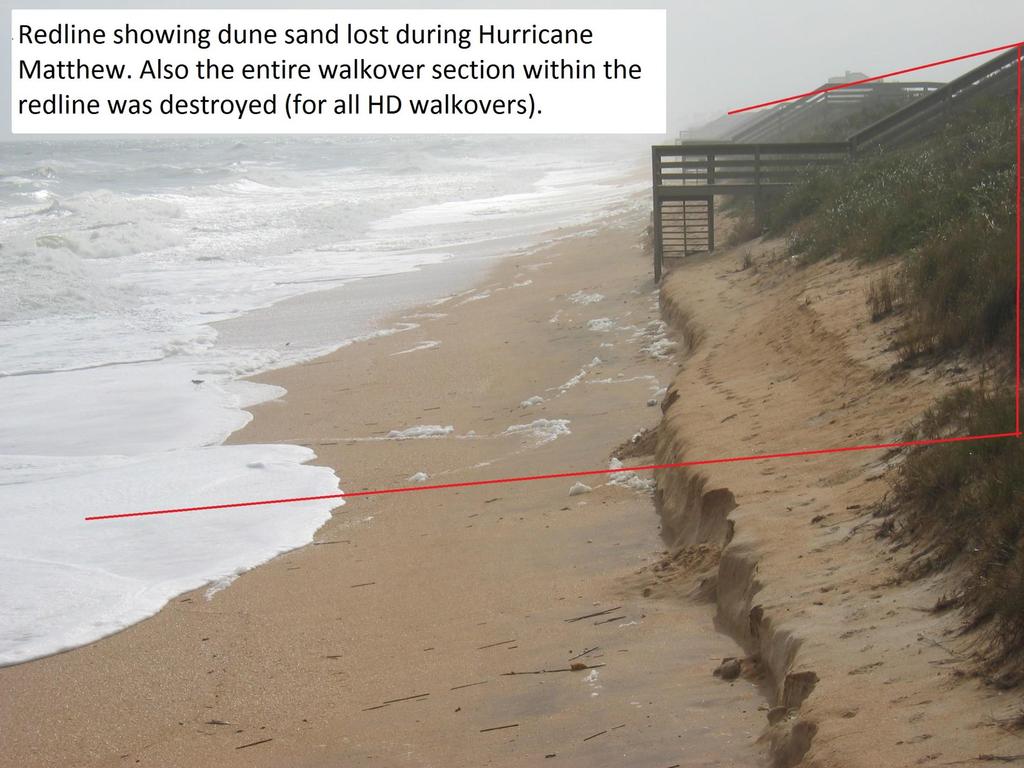
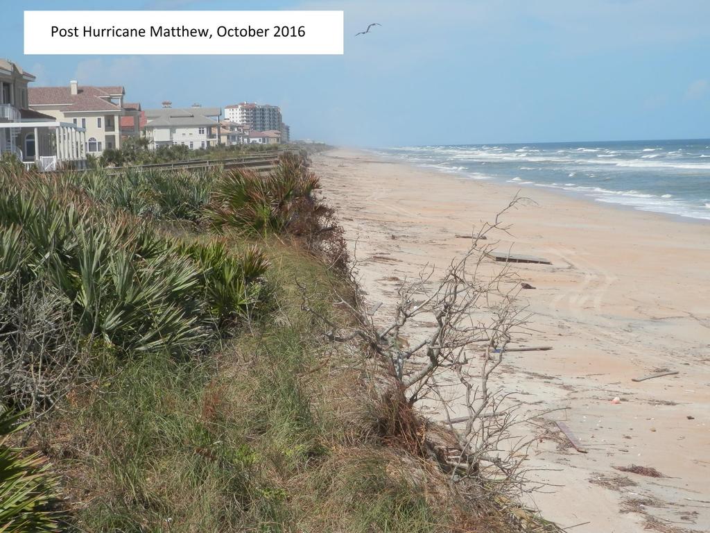
1 October 7, 2016 Hurricane Matthew Rakes the East Coast of Flagler County for 18.1 Miles Hammock Dunes Suffers Penetration of the Ocean into the Community; has a ft. Wide Triangular Section of the Dune Face Moved to the Ocean Floor; and All Walkover Stair Ends Destroyed
2 Project Team formed one week after Matthew David Eckert (Team Leader) Mike Gill (Legal and FEMA filing) Marge Rooyakkers (County Interface) Bruce Aiello (Financing & Budgeting) David Yoder (Engineering and Walkovers)
3
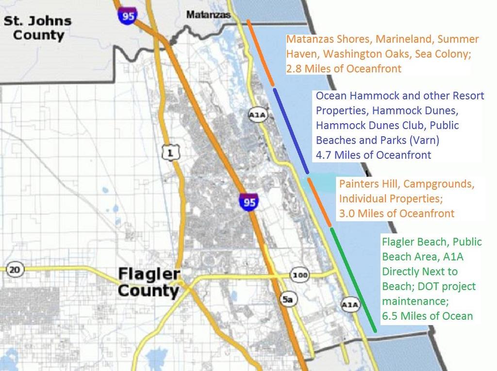
4 18.1 Miles of Oceanfront is Key to the Financial Health of Flagler County Recreation, Restaurant, and other commercial activities thrive on the Ocean Hammock Dunes and the Ocean Hammock Resort Properties bring tourism and seasonal business A1A is a critical scenic route for local activity The County and State want continued population growth
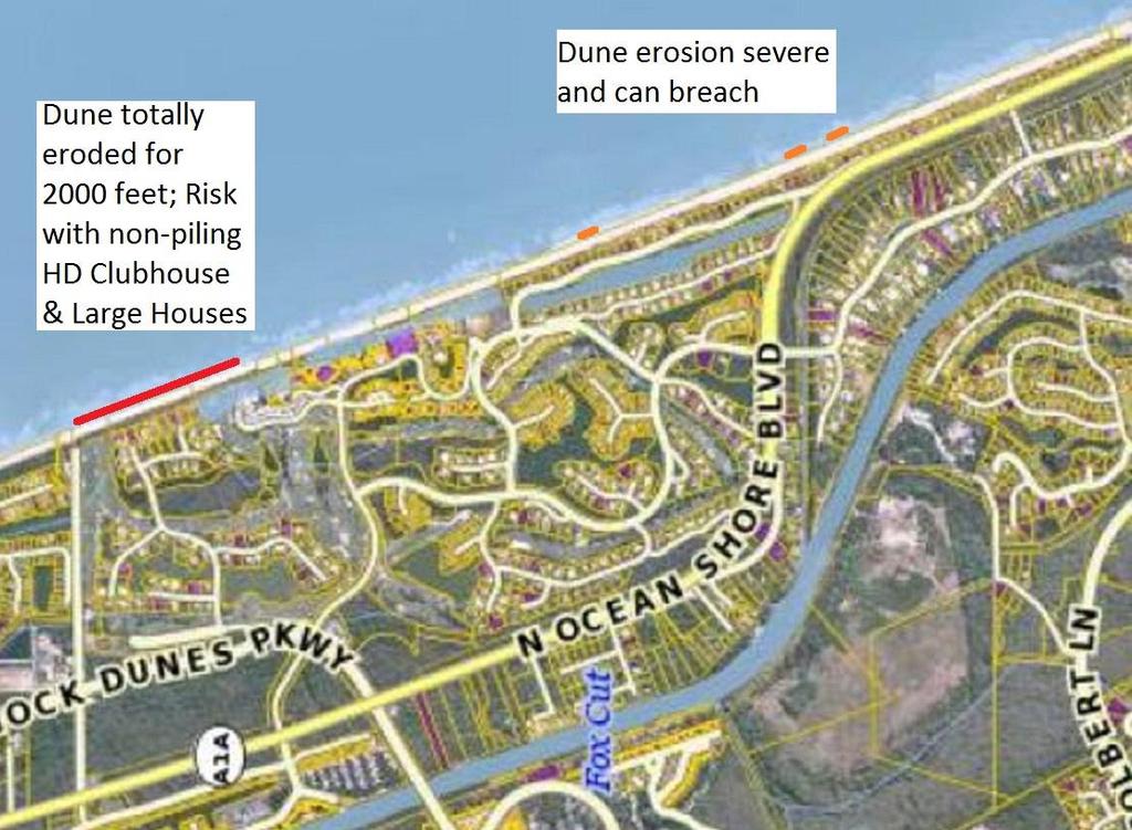
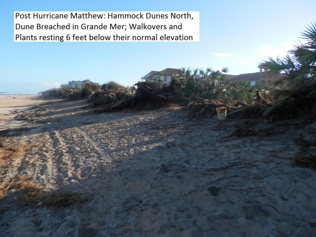
5 Matthew s Angry Ocean Penetrated the Dune into Communities, or onto roads, in many locations All along Flagler Beach South of Varn Park to A1A The Northern 2000 feet of Hammock Dunes into Grande Mer Jungle Hut Road, 16 th Street, Sea Colony; Ocean Hammock Breaches Washington Oaks formed a new Ocean Inlet Completely Flooded Summer Haven Nearly breached into Hammock Dunes in three other dune areas of Playa del Sur and Carino la Mer; 2.3 miles of Dunes must be repaired
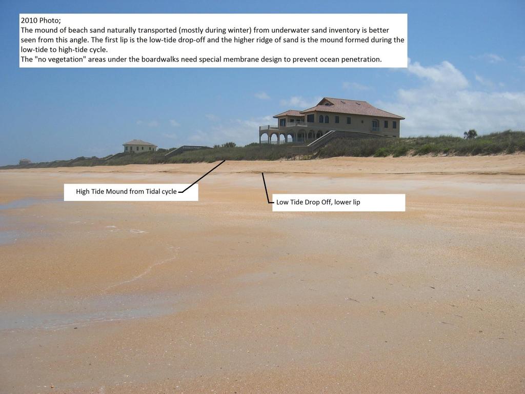
6
7
8 This 2000 foot section of lost HD Dune must be repaired during December 2016 A pyramidal shaped dune has been transported underwater Emergency FL-DEP Permits allow sand to be trucked from upland sources The volume of sand lost is 11,000 compacted cu. yds., or 900 truckloads December has 19 work days; 48 truckloads of sand/day or 6 trucks per hour at Jungle Hut Park (This is very difficult to implement) An alternative is to place a bulldozer or road scraper on the beach to recover sand from the tidal area for the same 19 days This requires the County to receive a FL-DEP Permit and to inspect work with a Marine Engineer
9
10
11 Calculation of Sand Lost from Original Dune Hammock Dunes has 2.3 miles of oceanfront 2.3 miles is 4,048 yards (or 12,144 feet) The triangular dune section lost is 3 yards high by 5 yards wide (average) Volume of sand lost is 30,360 cu. yds. Truckloads of sand are 12 cu. yds. (compacted); so 2530 truckloads Approx. cost of coquina sand is $250 per truckload; or $632,500 This amount excludes the 2000 ft. section of missing dune We do not know the cost to place the sand, form the dune, or vegetate the dune.
12
13 There are Alternatives to Trucked-In Sand The Sand System includes above-water sand and near shoreline underwater sand. Sand is cycled between these areas in a healthy, nondepleted system by natural wave and wind activity. Far shoreline sand can also be dredged. One 12 inch deep scrape of the lower beach sand, 30 feet wide along the full 2.3 miles would offer 14,520 cu. yds. of sand moved to the dune Wave action will refill this void with underwater sand (our coquina rock base protects us from deep erosion) Repeating this process 2-3 additional times would recover adequate sand to rebuild the dune, if nature cooperates and replenishes If sand recovery has a shortfall, some could be dredged or trucked.
14 Rough Cost Estimate for Lower Beach Sand Recovery A bulldozer and scraper can be rented for about $13,000 per month Two heavy equipment operators are estimated to be $10,000 per month Overhead for the contractor is assumed at 40% or $7,200 per month Work would be 8 hours+ per day using surveyed guidance markers; under County and/or DEP supervision Work on the beach/dune must take place around tide cycles 5 months in 2016/2017 is estimated at $151,000 (for operated equipment only) Complete the work before the May turtle nesting season
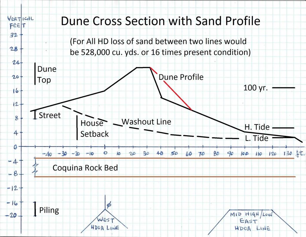
15 This work is necessary to Protect Hammock Dunes from Routine 2017 Tropical Storms The illustration on the next page shows the 100 year dune removal assumption from FL-DEP. This same erosion line may apply to weak dune areas, if a 10 year storm hits us, starting from the position of our damaged dune. On the other hand, our dune was remarkably stable for decades before Matthew However, to be prudent, the dune should be restored to its original profile by May 2017
16
17 What should be done? Must not cede land to the ocean as there is no extra land to be lost Immediate action during non-turtle-nesting-season must be to return dune to early 2000s profile and put walkovers back where they were. Fill dune breaches fast (major breach has already been filled) Move sand or procure sand to rebuild dune by May 2017 Repair community walkovers as first priority Repair residential walkovers in a way that the dune can be restored Implement actions for the long term health of the dune: vegetation, hardening, periodic maintenance
18 We are supporting the County to obtain FL-DEP Permits to Recover Sand from the Lower Beach It is the only alternative (except dredging) to be able to move sufficient sand to the 2.3 mile Dune Restoration in 5 months before May Bringing 4000 truckloads of sand through Jungle Hut closes this beach for 5 months, not even considering work to be done by the Ocean Hammock Communities. In 100 work days, this is 40 trucks per day. There is no Environmental logic to digging sand inland, burning energy for transport, destroying the beach with all terrain trucks making mile long trips to the sand dumping area of Jungle Hut. If we find that the lower beach sand is not naturally replenishing, we can dredge during May-November period to put the sand back.
19 How is the County Helping? Flagler County does not have Emergency Delegated Authority to Permit Lower Dune Sand Recovery We must use all paths to obtain this FL-DEP Permit We would like Commissioners to accompany us to Tallahassee to gain this permit and win State support for a County length project We are willing to be part of a larger County project, but only if our community is protected for the 2017 Hurricane Season Last Monday, the Commissioners agreed to assist HD in all these areas; an engineering design and FL-DEP Permit are critical
20 Design Alternatives Truck or Push sand back to reform dune (no reinforcing techniques) Truck or Push sand, reform dune and reinforce under all walkovers Construct semi-hard core inside dune and cover with sand to original profile (have maintenance program to keep hardening buried) Place sheet piling at current vertical face before pushing sand back into position, reforming the dune Internal or External Boulder Hardening Trucking or dredging for any shortfall in available sand County length design of their choice
21 Alternative Florida DEP Permit Flagler County FEMA Marine Engineer Contractor Rough Estimate HDOA % Pay Scrape Beach Needed FL-DEP Emergency Design Cline $500K % Restore Dune Qualified Inspect P&S Report Halifax Truck Sand Not Emergency Emergency Cline $2.0M % Restore Dune Needed Permit Qualified Inspect P&S Halifax Truck Sand Emergency Emergency Cline $2.1M % Restore Dune Not Permit Qualified Inspect P&S Harden under Needed? Design Halifax walkovers Dredge Sand Needed FL-DEP Partial Design $3.0M % GeoTube Needed Emergency Inspect??? Scrape Beach Needed Qualified Report Truck Sand Partial Design $4.0M % Sea Wall Needed FL-DEP Emergency Inspect??? Truck Sand-Rock Partial Design Cline $4.0M % Boulder Core Needed FL-DEP Emergency Inspect Halifax Truck Sand-Rock Partial Design Membrane Needed FL-DEP Emergency Inspect??? $5.0M % Riprap Surface Let County Lead Unknown State? Do Nothing 2017 Damage?
22 Walkover Plan (Community & Individual) Walkovers can only be temporarily repaired as dune restoration may require removal Walkover at Playa Del Sur will be the first repair (by end of November) The Condos may repair their walkovers if they chose, but they may have to be removed for dune restoration The HD Club may repair its walkover, but again it may require removal The individual walkovers are unstable and must have new longer legs placed down into the beach; attach to existing legs at cliff of dune Until these actions are taken, owner-devised-ladders down to the beach are discouraged, and the HDOA must insist on safety
23 Funding Assistance Our dunes and beaches are public and much of the dune is manmade; They are Facilities in FEMA terminology Jungle Hut, 16 th Street and Varn Parks were built and funded as part of the DRI for the full Hammock Project in 1984 We have reviewed all criteria for FEMA filing (Individual and Public Assistance) Retained Legal help for likely FEMA appeals Attended meetings with State Senators Jack Latvala & Travis Hudson for State Funding Supported County for full-length project funded: Locally, State, and Federal Are seeking a meeting with Governor Scott
24 Questions, Discussion & Feedback
Hammock Dunes Owners Association (HDOA)
") Hammock Dunes Owners Association (HDOA) Annual Members Meeting March 27, 2017 Attention Owners Florida Statute Specifies That Owners Wishing to Speak to a Published Agenda Item Must First Sign Up Prior
Hammock Dunes Owners Association (HDOA) Annual Members Meeting March 27, 2017 Attention Owners Florida Statute Specifies That Owners Wishing to Speak to a Published Agenda Item Must First Sign Up Prior
Hammock Dunes Owners Association (HDOA) Annual Members Meeting. March 31, 2014
 Annual Members Meeting. March 31, 2014") Hammock Dunes Owners Association (HDOA) Annual Members Meeting March 31, 2014 1 Agenda HDOA Board Introductions HDOA Club Relationship Election of Board Administrators Moving Forward Asset Acquisition
Hammock Dunes Owners Association (HDOA) Annual Members Meeting March 31, 2014 1 Agenda HDOA Board Introductions HDOA Club Relationship Election of Board Administrators Moving Forward Asset Acquisition
DAMAGE ASSESSMENT OF SAND FENCING GARDEN CITY, NORTH LITCHFIELD AND LITCHFIELD BEACH GEORGETOWN COUNTY, SC
 OF SAND FENCING GARDEN CITY, NORTH LITCHFIELD AND LITCHFIELD BEACH GEORGETOWN COUNTY, SC June 07, 2017 PREPARED FOR: GEORGETOWN COUNTY DEPARTMENT OF PUBLIC SERVICES PREPARED BY: The EARTHWORKS Group 11655
Hammock Dunes Owners Association (HDOA) Annual Members Meeting
 Annual Members Meeting") Hammock Dunes Owners Association (HDOA) Annual Members Meeting Thank You For Attending! March 30, 2015 1 Agenda HDOA Board Introductions HDOA Club Relationship Election of Board Administrators Moving Forward
Hammock Dunes Owners Association (HDOA) Annual Members Meeting Thank You For Attending! March 30, 2015 1 Agenda HDOA Board Introductions HDOA Club Relationship Election of Board Administrators Moving Forward
March 2, The Honorable Mayor Williams D. Sessoms, Jr. Members of City Council. Subject: Coastal CIP Presentation to City Council - March 6, 2018
 OFFICE OF THE CITY MANAGER (757) 385-4242 (757) 427-5626 FAX MUNICIPAL CENTER BUILDING 1, ROOM 234 2401 COURTHOUSE DRIVE VIRGINIA BEACH, VA 23456-9001 March 2, 2018 The Honorable Mayor Williams D. Sessoms,
A Brief History of the Town of Palm Beach Coastal Protection Program. Beach nourishment occurred in Palm Beach as far back as the 1940s.
 A Brief History of the Town of Palm Beach Coastal Protection Program Beach nourishment occurred in Palm Beach as far back as the 1940s. The Lake Worth Inlet Sand Transfer Plant was built in the late 1950s.
2011 Nags Head Beach Nourishment Project Update. Tim Kana & Haiqing Kaczkowski
 2011 Nags Head Beach Nourishment Project Update Tim Kana & Haiqing Kaczkowski NCBIWA Conference 3 April 2017 Outline of the Presentation 1 Review 2011 Nourishment Project Post-project monitoring efforts
City of Fort Lauderdale. Frequently Asked Questions. Proposed Sea Wall Ordinance
 City of Fort Lauderdale Frequently Asked Questions Proposed Sea Wall Ordinance The City of Fort Lauderdale is considering amending the Unified Land Development Regulations of the City of Fort Lauderdale
Sand Scripts. Maintenance Committee Report. A newsletter from the Hammock Dunes Owners Association (HDOA) PCPM Now SSMG
 PCPM Now SSMG") Sand Scripts February 2008 A newsletter from the Hammock Dunes Owners Association (HDOA) PCPM Now SSMG Palm Coast Property Management the management company for the Hammock Dunes Owners Association is
Sand Scripts February 2008 A newsletter from the Hammock Dunes Owners Association (HDOA) PCPM Now SSMG Palm Coast Property Management the management company for the Hammock Dunes Owners Association is
WORKSHEET 24: Sand dunes - Conservation and management
 SAND DUNES - CONSERVATION AND MANAGEMENT MEETING THE CHALLENGE Sand dunes are: Excellent natural protection for the land A great recreational and educational area A specialised wildlife habitat But they
PITA. PITA's campaign scores victory for public beach access. Christmas Fair celebrates 20th year. November 2014 INSIDE THIS ISSUE
 November 2014 PITA Sponsored by Plum Island Taxpayers and Associates, Inc. ( PITA ) Bringing Plum Island Together Volume 14, Issue 3 INSIDE THIS ISSUE - PITA S CAMPAIGN SCORES VICTORY OF ACCESS - CHRISTMAS
Overview of Highway 37 Project. Napa County Board of Supervisors December 20, 2016
 Overview of Highway 37 Project Napa County Board of Supervisors December 20, 2016 1 Project Location-Caltrans District 4 2 SR 37 Corridor Features 2 to 4 lane 21 mile corridor traversing Solano, Sonoma,
LAUNCH OF THE COASTAL ZONE MANAGEMENT TRUST
 A 60km stretch of coastline on the Yucatan Peninsula of Mexico is the testing ground for an idea that could protect fragile environments around the world: insuring coral reefs. The Economist World Ocean
Edisto Beach Renourishment and Groin Lengthening Project. Tim Kana Coastal Science & Engineering
 Edisto Beach Renourishment and Groin Lengthening Project Tim Kana Coastal Science & Engineering Hurricane Matthew 8 Oct 2016 Cat 1 Storm @ Edisto Beach Worst Surge Event Since DAVID in 1979 Tides ~ 5 ft
The History & Management of the Atlantic Intracoastal Waterway in Florida
 The History & Management of the Atlantic Intracoastal Waterway in Florida THE BEGINNING OF THE INTRACOASTAL WATERWAY IN FLORIDA CONSTRUCTED BY A PRIVATE COMPANY, THE FLORIDA EAST COAST CANAL COMPANY BETWEEN
Waterway Access and the Atlantic Intracoastal Waterway in Florida
 Waterway Access and the Atlantic Intracoastal Waterway in Florida Issues: Maintenance - Funding (costs), Infrastructure needs, permitting Management Consideration of the M-95 system, Cooperation among
Impact of Offshore Directed Forcing on Sediment Transport and Structural Integrity at Packery Channel, Corpus Christi Texas
 Google Earth 29 Aug 2017 Impact of Offshore Directed Forcing on Sediment Transport and Structural Integrity at Packery Channel, Corpus Christi Texas Deidre D. Williams Coastal Research Scientist Conrad
Hurricane Irma CITY OF MARATHON
 Hurricane Irma CITY OF MARATHON RESIDENT INFO PACKET CI.MARATHON.FL.US 305-289-5020 Check for updates at KeysRecovery.org CITY OF MARATHON, FLORIDA 9805 Overseas Highway, Marathon, Florida 33050 Phone:
Tallahassee-St. Marks Historic Railroad Trail
 Revitalizing a Historic Trail Designated as a National Recreation Trail, the 16-mile Tallahassee-St. Marks Historic Railroad Trail has been enjoyed by countless bicyclists, runners, and outdoor enthusiasts
Geographic Response Plan Map: EFL-40 ]^4011. ! Manatee [v NERR. National Park. Naval Facility. Piping Plover. Power Plant. Recreational Fishing
![Geographic Response Plan Map: EFL-40 ]^4011. ! Manatee [v NERR. National Park. Naval Facility. Piping Plover. Power Plant. Recreational Fishing](/thumbs/91/105050028.jpg "Geographic Response Plan Map: EFL-40 ]^4011. ! Manatee [v NERR. National Park. Naval Facility. Piping Plover. Power Plant. Recreational Fishing") 29 22'30"N 81 7'30"W!E(! EFL40-01 Basin Bulow Creek State Park Addison Blockhouse Historic State Park NRC - Ormond Beach Warehouse Equipment Site (ID JAX-E8) River Basin k k Marsh Aquatic Preserve!S( 200
29 22'30"N 81 7'30"W!E(! EFL40-01 Basin Bulow Creek State Park Addison Blockhouse Historic State Park NRC - Ormond Beach Warehouse Equipment Site (ID JAX-E8) River Basin k k Marsh Aquatic Preserve!S( 200
Overview of Highway 37 Project. Novato Rotary November 4, 2016
 Overview of Highway 37 Project Novato Rotary November 4, 2016 Project Location-Caltrans District 4 SR 37 Corridor Features Two to Four lane 21 mile corridor traversing Solano, Sonoma, and Marin Counties.
Standard Operating Procedures Debris Management. Concept of Operations
 Concept of Operations Lead Agency Support Agencies Standard Operating Procedures Debris Management Franklin County Road Department (FCRD) Apalachicola Streets Department (ASD) Carrabelle Streets and Roads
The Galveston Seawall
 Coastal and Ocean Engineering ENGI.8751 Undergraduate Student Forum Faculty of Engineering and Applied Science, Memorial University, St. John s, NL, Canada. March, 2013 The Galveston Seawall Mark Harvey
Port of Durban. Entrance Channel Widening & Deepening Project Completion Function. 31 March 2010
 Port of Durban Entrance Channel Widening & Deepening Project Completion Function 31 March 2010 Presented by: Theunis Steenkamp Project Director Natcor 1 The saying goes.. THE JOB IS NOT OVER UNTILL THE
OPEN CELL SHEET PILE TECHNOLOGY. Presentation to Alaska State Legislature, House Finance Committee
 OPEN CELL SHEET PILE TECHNOLOGY Presentation to Alaska State Legislature, House Finance Committee OPEN CELL SHEET PILE Technology Retaining Wall System Patents Obtained by PND Engineers ARRC Dock, Seward,
Southwind Marina Sinton Drive Pensacola, Florida Unique Opportunity to Acquire a 90 Slip Marina With Excellent Investment Potential
 Urban Realty Southeast is pleased to present Southwind Marina 10121 Sinton Drive Pensacola, Florida 32507 Unique Opportunity to Acquire a 90 Slip Marina With Excellent Investment Potential Closest marina
^ox, 7. Environment Agency. Hayling Island North Strategy *. M ^, v. * > -.
 ^ox, 7 Environment Agency Hayling Island North Strategy *. M ^, v. * > -. Consultation Document for Preferred Coastal Defence Options - Septem ber 2005 We are the Environment Agency. It s our job to look
E190 REPLACEMENT & FLEET UPDATE JULY 11, 2018
 1 E190 REPLACEMENT & FLEET UPDATE JULY 11, 2018 SAFE HARBOR This presentation contains forward-looking statements within the meaning of the Private Securities Litigation Reform Act of 1995, Section 27A
HARBOR INFRASTRUCTURE INVENTORIES Erie Harbor, PA
 HARBOR INFRASTRUCTURE INVENTORIES Erie Harbor, PA Harbor Location: Erie Harbor is located on the southern shore of Lake Erie in the City of Erie, PA about 98 Miles southwest of Buffalo. Authority: River
Ashford Lake Property Owners Association Annual Meeting October 6, 2018 Ashford Town Hall, Lower Level Meeting Room
 Ashford Lake Property Owners Association Annual Meeting October 6, 2018 Ashford Town Hall, Lower Level Meeting Room 1. Call to order: Tom Barry Tom Barry called the meeting to order at 9:05. Those Board
COASTAL CONSERVANCY. Staff Recommendation June 5, 2008 GUALALA BLUFF TRAIL OPERATIONS AND MAINTENANCE
 COASTAL CONSERVANCY Staff Recommendation June 5, 2008 GUALALA BLUFF TRAIL OPERATIONS AND MAINTENANCE File No. 08-047-01 Project Manager: Deborah Hirst RECOMMENDED ACTION: Consideration and possible Conservancy
The reasons why coastal management is needed in Minehead:
 1. Resource 1: Why did Minehead need new sea defences? Coastal management in Minehead In pairs, read the following resource and highlight the reasons why coastal management was needed in Minehead. The
U.S. Army Corps of Engineers Wilmington District
 U.S. Army Corps of Engineers Wilmington District 2012 East Coast - WEDA October 9-11, 2012 Ongoing & Upcoming Contracts US Army Corps of Engineers Wilmington District Ongoing Contracts Project Quantity
BOARD OF COUNTY COMMISSIONERS OKALOOSA COUNTY, FLORIDA
 TOURIST DEVELOPMENT SERVICE AREA: CULTURE/RECREATION BOARD OF COUNTY COMMISSIONERS OKALOOSA COUNTY, FLORIDA DEPARTMENT/PROGRAM: TOURIST DEVELOPMENT - MARKETING PROGRAM DESCRIPTION: Okaloosa Tourist Development
- NEUTRAL. Savannah ORGIA PETER SALAMON MASTER OF URBAN DESIGN THESIS SAVANNAH COLLEGE OF ART AND DESIGN MAY 2015
 - NEUTRAL + RE δge Savannah ORGIA PETER SALAMON MASTER OF URBAN DESIGN THESIS SAVANNAH COLLEGE OF ART AND DESIGN MAY 2015 PANAMA CANAL EXPANSION THE CATALYST Suez 1869-6,000 km Panama 1914-13,000 km Prior
Guide to Siting of Seawalls January 13, 2014 by Michael Walther, P.E., D.CE, President - Coastal Tech
 January 13, 2014 by Michael Walther, P.E., D.CE, President - Coastal Tech mwalther@coastaltechcorp.com Prepared for the Sea Turtle Conservancy http://www.conserveturtles.org/ Introduction Overview: This
TRANSMITTAL. Please contact me with any questions. 7 Spruce Road, Freeport, ME T: (207)
") BAKER DESIGN CONSULTANTS Civil, Marine and Structural Engineering To: Alex Jaegerman FAICP Director of Planning & Development Town of Yarmouth 200 Main Street PO Box 907 Yarmouth, ME 04096 From: Barney
BAKER DESIGN CONSULTANTS Civil, Marine and Structural Engineering To: Alex Jaegerman FAICP Director of Planning & Development Town of Yarmouth 200 Main Street PO Box 907 Yarmouth, ME 04096 From: Barney
IMPACTS OF THE RECENT TSUNAMI ON THE BUNDALA NATIONAL PARK THE FIRST RAMSAR WETLAND IN SRI LANKA
 IMPACTS OF THE RECENT TSUNAMI ON THE BUNDALA NATIONAL PARK THE FIRST RAMSAR WETLAND IN SRI LANKA by C.N.B. Bambaradeniya, IUCN The World Conservation Union, Sri Lanka Country Office (Email: cnb@iucnsl.org)
Using Managed Retreat to Address Coastal Erosion in Brewster
 Using Managed Retreat to Address Coastal Erosion in Brewster Chris Miller, Director, Brewster Department of Natural Resources CMiller@brewster-ma.gov Brewster, Massachusetts Almost 1/3 of town preserved
Runway Roughness Evaluation- Boeing Bump Methodology
 FLIGHT SERVICES Runway Roughness Evaluation- Boeing Bump Methodology Michael Roginski, PE, Principal Engineer Boeing Airport Compatibility Engineering ALACPA XI Seminar, Santiago, Chile September 1-5,
Holgate Taxpayers Association Spring Membership Meeting Minutes - June 2, 2018
 Holgate Taxpayers Association Spring Membership Meeting Minutes - June 2, 2018 The meeting was called to order by Dan Macone at 10.01 a.m. Dan thanked the membership for their support and remarked that
Great Lakes Navigation Stakeholder Meeting Shallow Draft Harbor Needs & Issues
 Great Lakes Navigation Stakeholder Meeting Shallow Draft Harbor Needs & Issues Mike O Bryan U.S. Army Corps of Engineers Great Lakes Navigation Business Line Manager March 11, 2015 US Army Corps of Engineers
Cat Island Chain Background & Access Guide
 Cat Chain Background & Access Guide Brown County Port & Resource Recovery Department 2561 S. Broadway, Green Bay, WI 54304 (920) 492-4950 www.portofgreenbay.com January 2018 1 Restoration of the Cat Chain
Coastal Management: Treasure Island - Long Key Nourishment
 Coastal Management: Treasure Island - Long Key Nourishment Project Completed - October 20, 2010 The nourishment of Treasure Island and Long Key (TI/LK) beaches began in late July of 2010. The previous
Request for Proposal National Tropical Botanical Garden Lower Limahuli Preserve Emergency Stream Debris Removal
 Request for Proposal National Tropical Botanical Garden Lower Limahuli Preserve Emergency Stream Debris Removal I. Summary of Work Bids are solicited for the emergency removal of debris deposited in the
Figure 7. Dragline at Cape Coral, Figure 8. Cape Coral oblique aerial photograph, 1959.
 The dredge-and-fill method, which would later be criticized for its environmental impact, employed in the peak years of the early 1960s as many as four dredges and ten draglines, which at times operated
Access: The rocky shoreline is only accessible via private property.
 10. Whale Cove Site description: Whale Cove is a small cove fringed by private homes and condominiums with diverse and relatively undisturbed rocky intertidal and subtidal habitat located approximately
Brevard County Utility Services Department
 Brevard County Utility Services Department April 3, 2018 Jim Helmer, Department Director Brian Sorensen, W/WW Manager 1 Utility Services Department 9 TREATMENT PLANTS 6 WASTEWATER, 3 WATER 163 EMPLOYEES
THAT the Board approve the final proposed concept plan for the Jericho Marginal Wharf site as shown in Figure C-4 of Appendix C.
 Date: January 17, 2012 TO: Board Members Vancouver Park Board FROM: General Manager Parks and Recreation SUBJECT: Jericho Marginal Wharf Phase 2 Concept Plan RECOMMENDATION THAT the Board approve the final
A1A North Corridor Multi-Use Trail. Vilano to Ponte Vedra Beach
 A1A North Corridor Multi-Use Trail Vilano to Ponte Vedra Beach The A1A North Corridor Community Area comprised of five unincorporated areas: Porpoise Point Vilano Beach Surfside Beach North Beach South
S Central Coast Heritage Protection Act APRIL 21, 2016
 STATEMENT OF GLENN CASAMASSA ASSOCIATE DEPUTY CHIEF, NATIONAL FOREST SYSTEM U.S. FOREST SERVICE U.S. DEPARTMENT OF AGRICULTURE BEFORE THE UNITED STATES SENATE COMMITTEE ON ENERGY AND NATURAL RESOURCES
A newsletter from the Hammock Dunes Owners Association
 HDOA Board Members, with Communities Elected By and Term Expiration Dates George Bagnall, President; Granada Estates; March 2012. Cosmo DiPerna, Vice President and liaison to the Design Review Committee;
Unit 1 Lesson 1: Introduction to the Dry Tortugas and Sustainable Seas Expedition
 Unit 1 Lesson 1: Introduction to the Dry Tortugas and Sustainable Seas Expedition Lesson Objectives: Introduce students to the historical, geographic, and ecological importance of the Dry Tortugas. Introduce
UNITED STATES DEPARTMENT OF THE INTERIOR BUREAU OF LAND MANAGEMENT MANUAL TRANSMITTAL SHEET
 Form 1221-2 (June 1969) UNITED STATES DEPARTMENT OF THE INTERIOR BUREAU OF LAND MANAGEMENT MANUAL TRANSMITTAL SHEET Release 8-83 Date Subject 8353 Trail Management Areas Secretarially Designated (Public)
ARTICLE 7 MOBILE HOME AND RECREATIONAL VEHICLE PARKS AND CAMPGROUNDS
 ARTICLE 7 MOBILE HOME AND RECREATIONAL VEHICLE PARKS AND CAMPGROUNDS Section 701. APPLICABILITY Where a municipality has no subdivision or land development ordinance the provisions of this article shall
The Joint Charlotte County - Punta Gorda and Lee MPO Meeting has changed from 10:00 a.m. to 9:30 a.m.
 The Joint Charlotte County - Punta Gorda and Lee MPO Meeting has changed from 10:00 a.m. to 9:30 a.m. JOINT MEETING OF THE CHARLOTTE COUNTY-PUNTA GORDA METROPOLITAN PLANNING ORGANIZATION BOARD AND LEE
APPENDIX D: SUSTAINABLE TRAIL DESIGN. APPENDICES Town of Chili Parks and Recreation Master Plan Update
 APPENDIX D: SUSTAINABLE TRAIL DESIGN APPENDICES Town of Chili Parks and Recreation Master Plan Update Sustainable Trail Construction Sustainable trails are defined by the US Forest Service as trails having
The combined Planning and Zoning and Council Meeting was called to order at 7:00 p.m.
 Lake Remediation Master Plan The combined Planning and Zoning and Council Meeting was called to order at 7:00 p.m. Roll Call: Councilman Joe Curl, Councilwoman Tiffany Hughes, Councilwoman Lori Howard,
On the Edge with Mangroves
 On the Edge with Mangroves (Author s Note: This is the twenty-second in a series of articles by members of the City of Sanibel Vegetation Committee dealing with vegetative matters of concern to island
HYATT HOTELS CORPORATION 2012 ANNUAL MEETING OF STOCKHOLDERS JUNE 13, 2012
 HYATT HOTELS CORPORATION 2012 ANNUAL MEETING OF STOCKHOLDERS JUNE 13, 2012 FORWARD LOOKING STATEMENTS This presentation contains forward-looking statements within the meaning of the Private Securities
Clam Harbour Provincial Park
 Clam Harbour Provincial Park Public Engagement Session Thursday, September 14 th, 2017 5:30pm 7:30pm Webbers Store 11470 Nova Scotia Trunk 7 Lake Charlotte, NS Agenda Overview of the Provincial Parks System
White Mountain National Forest. Pond of Safety Accessible Trail & Shoreline Access Project. Scoping Report. Township of Randolph Coos County, NH
 White Mountain National Forest United States Department of Agriculture Forest Service Eastern Region Pond of Safety Accessible Trail & Shoreline Access Project Township of Randolph Coos County, NH Scoping
Permeable RECREATIONAL TRAILS
 SMART EARTH SOLUTIONS Permeable RECREATIONAL TRAILS GEOWEB GEOPAVE GEOTERRA Innovative Solutions for Designing & Building Trails. Trail Surface Stabilization The key to planning and building trails into
COASTAL CONSERVANCY. Staff Recommendation March 25, 2004 SONOMA COUNTY COASTAL TRAIL, PHASE I. File No Project Manager: Richard Retecki
 COASTAL CONSERVANCY Staff Recommendation March 25, 2004 SONOMA COUNTY COASTAL TRAIL, PHASE I File No. 03-142 Project Manager: Richard Retecki RECOMMENDED ACTION: Authorization to disburse up to $455,000
GOLDEN EARS PROVINCIAL PARK
 GOLDEN EARS PROVINCIAL PARK Trail Information as of October 10 th 2015 Do not underestimate the mountainous wilderness of Golden Ears Provincial Park. The combination of rugged terrain and rapidly changing
1 Sycamore Adventure Risk Benefit Assessment for Sycamore Adventure
 1 Sycamore Adventure 01384 813755 Risk Benefit Assessment for Sycamore Adventure Benefit of Adventure Play for Children & Young People: 1. Fun 2. Self Directed Play, opportunity to follow own interests
Ongoing Projects 3/16/2017 2
 Ongoing Projects 26 th to 34 th Street, West Avenue to Bay Avenue ($6.5 million contract awarded) 46 th Street (complete) 29 th Street Firehouse South Jersey Gas improvements 34 th Street playground repairs
WAIMAKARIRI DISTRICT COUNCIL REPORT. Craig Sargison, Manager Community and Recreation
 WAIMAKARIRI DISTRICT COUNCIL REPORT FILE NO: GOV-26-01-07, CPR-04-04-01 / 150609090834 REPORT TO: Kaiapoi Community Board DATE OF MEETING: 15 June 2015 FROM: SUBJECT: Craig Sargison, Manager Community
MORGAN CREEK GREENWAY Final Report APPENDICES
 APPENDICES MORGAN CREEK GREENWAY Appendix A Photos of Existing Conditions in Trail Corridor Photos of existing conditions Main trail corridor - February 2009 Photos of existing conditions south bank Morgan
566± acres total - WILL DIVIDE Volusia County, FL
 L IC E N S E D HUNTING P RESERVE ts Q u a i l ahi ul anb l e are av r info! fo CALL TODAY LAKEFRONT PROPERTY PERFECTION This ranch lies on a natural sand ridge in North Volusia County, Florida and has
Mighty Glaciers. Mighty Glaciers. Visit for thousands of books and materials.
 Mighty Glaciers A Reading A Z Level M Leveled Reader Word Count: 684 LEVELED READER M Mighty Glaciers Written by Ned Jensen Visit www.readinga-z.com for thousands of books and materials. www.readinga-z.com
Florida s Most Remarkable Beach Resort. Jacoby D E V E L O P M E N T
 Florida s Most Remarkable Beach Resort Jacoby D E V E L O P M E N T Florida s Most Remarkable Beach Resort The World s First Oceanarium Built in 1938 as Marine Studios, an underwater motion picture studio
Defending the coast at Dawlish Warren
 508 546 Sólheimajökull: Defending the coast a retreating Dawlish Icelandic Warrenglacier By By Simon Hilary Edge Sampson Today, ice covers around 10% of the A case study about world s surface. But, for
TANZANIA CIVIL AVIATION AUTHORITY AIR NAVIGATION SERVICES INSPECTORATE. Title: CONSTRUCTION OF VISUAL AND INSTRUMENT FLIGHT PROCEDURES
 Page 1 of 8 1. PURPOSE 1.1. This Advisory Circular provides guidance to personnel involved in construction of instrument and visual flight procedures for publication in the Aeronautical Information Publication.
Bear Creek Habitat Improvement Project
 06/10/10 Bear Creek Habitat Improvement Project El Paso County, Colorado Pike National Forest and Colorado Springs Utilities Owned Land Report prepared by: Eric Billmeyer Executive Director Rocky Mountain
Katrina Recovery: Helping Hands. Biloxi, Mississippi November 2005
 Katrina Recovery: Helping Hands Biloxi, Mississippi November 2005 The Call October e-mail from the National Diaconate Office: We ve been saying wait, but NOW is the time! Get yourself here, bring sleeping
The Trusts Dredging Strategy
 NAG Meeting 21st September 2012 Graham Holland Head of Asset Management Current Review Why Now? Previous practices not always well defined Processes required greater clarity The need to apply asset management
DOES BEACH NOURISHMENT PROTECT PROPERTY VALUES FROM HURRICANES? THE CASE OF THE 2004 AND 2005 HURRICANES
 DOES BEACH NOURISHMENT PROTECT PROPERTY VALUES FROM HURRICANES? THE CASE OF THE 2004 AND 2005 HURRICANES James Murley, Director, Center for Urban and Environmental Solutions (CUES), FAU Dr. Lenore Alpert,
Planners slam pipeline permit applications
 Planners slam pipeline permit applications January 31, 2018 BY JOHN BRUCE STAFF WRITER Dominion employees were present to answer planning commission questions and comment about the construction storage
St. Augustine Port, Waterway & Beach District. St. Augustine Inlet 2013 draft Inlet Management Plan. March 19, 2013
 Division of Water Resource Management St. Augustine Port, Waterway & Beach District St. Augustine Inlet 2013 draft Inlet Management Plan March 19, 2013 Discussion Outline Florida Statutes Florida Inlets
Triangle Land Conservancy Conservation Area Monitoring Report Carolina North
 Triangle Land Conservancy Conservation Area Monitoring Report Carolina North Property Name: Crow Branch Conservation Area Date of visit: 4/8/2015 County: Orange Property Type: Restrictive Covenants Local
Alternative Highest & Best Use Analysis Boutique Hotel
 Alternative Highest & Best Use Analysis In response to numerous comments received from the public, as well as issues raised by the CCC in the Appeal Staff Report Substantial Issue Determination, the following
Specification for Grip blocking using Peat Dams
 Technical Guidance Note 1 Specification for Grip blocking using Peat Dams 1. Introduction Moorland drains (grips) have been dug across much of the Yorkshire upland peatlands. Many of these grips have become
RE: Extreme Avalanche Hazard at New Jumbo Glacier Resort (JGR) Daylodge Building Site
 Daylodge Building Site") To: Ms. Autumn Cousins Manager, Policy and Compliance BC Environmental Assessment Office, via Email to autumn.cousins@gov.bc.ca and eao.compliance@gov.bc.ca PO Box 9426 Stn Prov Govt Victoria, BC V8W 9V1
To: Ms. Autumn Cousins Manager, Policy and Compliance BC Environmental Assessment Office, via Email to autumn.cousins@gov.bc.ca and eao.compliance@gov.bc.ca PO Box 9426 Stn Prov Govt Victoria, BC V8W 9V1
Skier s Edge Vail, CO Architect: Gail Folwell
 Skier s Edge Vail, CO Architect: Gail Folwell The Skier s Edge is a bronze sculpture at the base of the Vista Bahn ski lift a the Vail ski resort. designed a stainless steel skeleton to fit within the
Riverine Sand Mining/Scofield Island Restoration (BA-40)
") Riverine Sand Mining/Scofield Island Restoration (BA-40) Conference on Ecological and Ecosystem Restoration Kenneth Bahlinger, CPRA Project Manager July 31, 2014 committed to our coast committed to our
Riverine Sand Mining/Scofield Island Restoration (BA-40) Conference on Ecological and Ecosystem Restoration Kenneth Bahlinger, CPRA Project Manager July 31, 2014 committed to our coast committed to our
COSTA MAYA HIGH POTENTIAL INVESTMENT OPPORTUNITY & PROPOSAL
 COSTA MAYA HIGH POTENTIAL INVESTMENT OPPORTUNITY & PROPOSAL Introduction This investment analysis and proposal was developed to provide investors with an accurate representation of the investment potential
COASTAL CONSERVANCY. Staff Recommendation December 2, 2004 COYOTE HELLYER COUNTY PARK BAY AREA RIDGE TRAIL
 COASTAL CONSERVANCY Staff Recommendation December 2, 2004 COYOTE HELLYER COUNTY PARK BAY AREA RIDGE TRAIL File No. 04-057 Project Manager: Amy Hutzel RECOMMENDED ACTION: Authorization to disburse up to
Hurricane Irma: Palm Beach County Coastal Storm Damage Assessment
 Project Area: Coral Cove Park Location: R1 to R7.5 Project Length: 5,170 ft Estimated Volumetric Loss: 38,296 cy Pre-Storm Assessment Date: August 22, 2017 General observations: 30 ft loss of dry beach
Pump Stations...more than just pumps
 Task Force Hope Status Report Newsletter March 13, 2013 Pump Stations...more than just pumps Photo by Jerry Baggett Pump Station 11, Algiers Canal Repairs and Fronting Protection Repaired pump stations
Heritage Management in Iceland in Times of Changing Climate Guðmundur St. Sigurðarson
 Heritage Management in Iceland in Times of Changing Climate 4.5.2017 Guðmundur St. Sigurðarson Minjastofnun Íslands The Cultural Heritage Agency of Iceland The Cultural Heritage Agency of Iceland is an
April 4, 2014 Chuck McGinness, FDOT TREASURE COAST TRAFFIC REPORT April 4 through April 11, 2014
 April 4, 2014 Chuck McGinness, 954-777-4090 Chuck.McGinness@dot.state.fl.us FDOT TREASURE COAST TRAFFIC REPORT April 4 through April 11, 2014 TREASURE COAST Construction and maintenance-related lane closures
10TH ANNUAL WOLFE RESEARCH GLOBAL TRANSPORTATION CONFERENCE MAY 23, 2017
 1 10TH ANNUAL WOLFE RESEARCH GLOBAL TRANSPORTATION CONFERENCE MAY 23, 2017 SAFE HARBOR This presentation contains forward-looking statements within the meaning of the Private Securities Litigation Reform
DRAFT. Dorabelle Campground Rehabilitation
 DRAFT Dorabelle Campground Rehabilitation September 2012 1.1 REGIONAL SETTING AND PROJECT LOCATION The Dorabelle Campground is located on the western shore of Shaver Lake in Fresno County, California (Section
History of the Oak Island, NS, Treasure Hunt
 History of the Oak Island, NS, Treasure Hunt Western Shore Money Pit Oak Island 1992 Presentation by D'Arcy O'Connor to Independent Activities Period 2008 Massachusetts Institute of Technology Cambridge,
SUMMER VILLAGE OF SILVER SANDS. Municipal Development Plan
 SUMMER VILLAGE OF SILVER SANDS Municipal Development Plan Bylaw 253-2014 Adopted August 22, 2014 Summer Village of Silver Sands Municipal Development Plan Bylaw No. 253-2014 Page 2 1 INTRODUCTION 1.1 SETTING
CAS Case Study: Mullion Harbour, adapting to a stormier future
 t The National Trust Coastal Adaptation Strategy Case Study: Mullion Harbour Authors: Ed Bartlett, Alastair Cameron, Phil Dyke & Adrian Woodhall June 2010 CAS Case Study: Mullion Harbour, adapting to a
Orienteering. The fundamental outdoors skill!
 The fundamental outdoors skill! Orienteering Nothing will make you feel more confident in the out of doors like knowing how to find your way in the woods. Orienteering Prepared by: Jeffrey Lybarger Assistant
Frequently Asked Questions
 CAA Funding Review Why has CAA s funding been reviewed? New Zealand has a well-regarded civil aviation system and a good aviation safety record. However, both the government and a range of reviews (including
VIETNAM S NEWEST TOURIST ATTRACTION
 Welcome to the November 2012 issue of the Vietnam Resort Report. Last month we finished the fourpart series Why, Where, When, and How to invest in Vietnam s Coastal Tourism. This month s report has less