Orienteering. The fundamental outdoors skill!
|
|
|
- Osborne Berry
- 5 years ago
- Views:
Transcription
1 The fundamental outdoors skill! Orienteering Nothing will make you feel more confident in the out of doors like knowing how to find your way in the woods.
2 Orienteering Prepared by: Jeffrey Lybarger Assistant Scoutmaster, Troop 467, Atlanta, GA The presentation was developed in partial completion of the Boy Scouts of America Wood badge adult leadership training, WB This presentation is for the specific purpose of volunteer youth orienteering training and is not to be used for any commercial purpose.

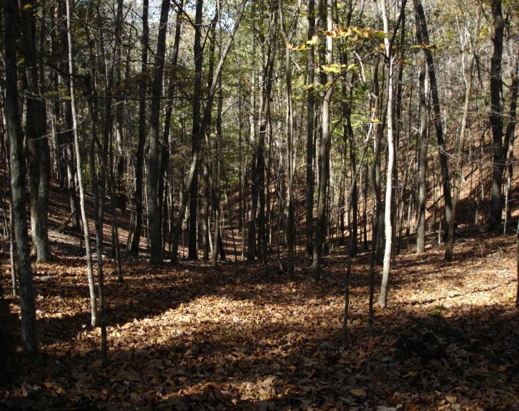
3 Open Woods Open Forest/Woods have trees that are well spaced so that you can easily run between them. In the winter, you can usually see long distances in open woods.

4 Open Woods Open Forest/Woods have trees that are well spaced so that you can easily run between them. In the winter, you can usually see long distances in open woods. The map looks white for these areas.

5 Open Woods Open Forest/Woods have trees that are well spaced so that you can easily run between them. Some patches of thicker vegetation can be met that are not large enough to appear on the map as a dense (green) area.


6 Open Land Open fields typically are yellow/orange on a map. They vary from cut grass to knee high scrub growth. They can change a lot over time.
 or green (dense forest),")
7 Open Land This shows the edge of an open field and dense forest. This line may appear as orange next to white (open forest) or green (dense forest), depending on the run ability.

8 Open Land This shows the edge of an open field and open forest. This line may appear as orange next to white (open forest).


9 Open Land This shows the edge of the previous open field looking from the field back into open forest.

10 Open Land This is edge of an open field. The vegetation has changed to taller growth with small trees. (5 years has passed since the map was made.)

11 Open Land This is edge of an open field. The vegetation has changed to taller growth with small trees. (5 years has passed since the map was made.)

12 Lakes NEVER!!! Try to wade or cross a lake as part of a hike or orienteering event. IT CAN BE VERY DANGEROUS.


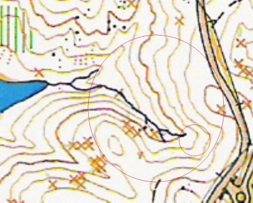
13 Creeks Most creeks are small and intermittent (only have water at some times). This creek is fast and wide (about 8ft) and CAN BE DANGEROUS.


14 Creeks This is a convergence point of 2 creeks. A creek is coming in on the right, about where the pile of dirt is located. Further down, you can see the lake where they empty into.

15 Creeks This creek bed meanders a lot. You can see steep banks along this portion of this creek.


16 Dense Growth Dense growth will be shown as a green area. The darker the green the poorer the run-ability through it. Avoid trying to go through this growth, but it can be used as a reference point on the map.

17 Dense Growth Vines are commonly found in areas of dense growth that has poor run-ability.

18 Dense Growth This shows the edge of an open forest and a line of dense forest. Notice the wall of smaller, tightly packed trees.

19 Dense Growth This shows a closer view of the smaller, tightly packed trees.


20 Felled Areas Felled areas are where trees have been cut either as a timber operation or for other park activities. Usually, you can find trees down.


21 Felled Areas Felled areas are where trees have been cut either as a timber operation or for other park activities. Usually, you can find trees down.


22 Felled Areas This was listed by the map maker as a felled area, but few trees were found and it sometimes difficult to tell them from open field areas.

23 Trails Trails are usually distinctive.

24 Trails Trails are usually distinctive. A curve in the trail provides an exact location

25 Trails If trails are through the woods, they can be leaf covered and sometimes lost, especially in the fall.

26 Trails A junction of trails provides an exact location.

27 Hills Hills are usually obvious features. You may need to decide whether to go over or around a hill. (This depends on your fitness. A 20 ft elevation climb is the same as running 100yds.) If you run around the side of a hill at the same contour, it is called contouring the hill.

28 Hills This hill can be easily seen and easily contoured around.

29 Hills This hill is not as steep. If a marker is at the summit, look around you and keep going uphill.

30 Re-entrantentrant V-Shaped contour features. We are looking uphill at this Re-entrant.

31 Re-entrantentrant V-Shaped contour features. We are looking downhill near the top of this Re- Entrant

32 Re-entrantentrant V-Shaped contour features. We are looking up from the bottom of the same Re- Entrant. When leaves are still on the trees, land contours are much harder to see.
33 Re-entrantentrant Distinctive larger Re-Entrant from the top.

34 Saddles Saddles are the low areas that run between two hills. You can see the beginnings of hills going off in both directions.

35 Saddles This boulder could be easily located because it rested in a saddle. This is the westward view to a low hillside.

36 Saddles This boulder could be easily located because it rested in a saddle. This is the eastward view to a low hillside of the same rock.

37 Rocks and Boulders Most large boulders will appear on the map and small ones, if in a group, will be marked as a boulder field. This rock is about 5ft. by 3ft., but only about a foot high.


38 Rocks and Boulders This size boulder will typically be marked on an orienteering map. It is about 8-10 ft. in diameter and about 4ft. high.


39 Rocks and Boulders This is a cluster of rocks and boulders.
.")
40 Rocks and Boulders This is a cluster of rocks (or rocky ground). It is usually a cluster of small black dots.


41 Rocks and Boulders This boulder is noted on the map and is at the edge of a clearing. A combination of two clearly obvious features makes this a great way to be absolutely sure where you are. It would make a good attack point.

42 Cairns Cairns are man-made rock piles and usually indicate prior activity, such as a homestead or farm.


43 Cairns Cairns are man-made rock piles and usually indicate prior activity, such as a homestead or farm.

44 Cairns Cairns are man-made rock piles and usually indicate prior activity, such as a homestead or farm.

45 Rootstock Rootstock are where trees have fallen and the roots of the tree are sticking up. Map makers will mark them if they are rootstocks of large trees. Usually a lot of mud is also showing.

46 Rootstock This is the same tree rootstock from the side where you can see the tree trunk laying on the ground.

47 Rootstock This is a cluster of fallen trees and rootstock. This likely occurred during a storm.

48 Rootstock However, not all are extremely large. This rootstock is old an dried. The map maker did put this rootstock on the map.

49 Man Made Objects: Road Road are easily found and can be important for relocation if you are lost.

50 Man Made Objects: Outlook Stand Stands, pavilions, picnic areas, and other recreation spots can be good points of reference.
")

51 Man Made Objects: Power Lines Overhead power lines are great lateral markers (handrails) and can be seen from some distance. Where these lines and the road intersect is an exact location.

52 Man Made Objects: Building Buildings can be good points of reference.


53 Man Made Objects: Ruins Ruins of old buildings can be good points of reference, but they can be harder to find. This chimney blends in with the trees. Old building foundations can be covered with leaves and foliage.


54 Man Made Objects: Cemetery Cemeteries are very distinctive, but sometimes map makers will plot isolated historical grave sites, and they can be difficult to locate.

55 Man Made Objects: Wells Wells, vents, and cisterns are distinct objects. IF ONE IS OPEN, STAY AWAY.


56 Bridges A bridge will appear as a black line over a river, stream, creek, or even over an inlet of a lake. This is a large foot bridge.

57 Bridges This bridge was marked as a single small black hash mark over a creek. It is a very small foot bridge.
 http://www.gaorienteering.")
58 My sincere thanks to the Georgia Orienteering Club for their support by allowing me to use GAOC maps for this project. (Especially Mr. Bill Farrell and Ms. Martha Carr)
59 Orienteering The fundamental outdoors skill! Check your compass often; Read your map always! No matter whether you are in a competitive orienteering race, on an Sunday walk or hiking at Philmont, Have Fun Orienteering.
Camp Jack Wright PERMANENT ORIENTEERING COURSE (2004)
") Camp Jack Wright PERMANENT ORIENTEERING COURSE (2004) WHAT IS ORIENTEERING? The skill which enables a person to navigate with a map. In the competitive sport, the winner is the person who finishes in the
Camp Jack Wright PERMANENT ORIENTEERING COURSE (2004) WHAT IS ORIENTEERING? The skill which enables a person to navigate with a map. In the competitive sport, the winner is the person who finishes in the
Figure 1 Understanding Map Contours
 Figure 1 Understanding Map Contours The light brown lines overprinted on topographic maps are called contour lines. They indicate the elevation above sea level of land features and thus permit you to view
Self-Guided Walk Langdale Pikes. Start & Finish: NT car park (free to members) at Sticklebarn - on the right just beyond the New Dungeon Ghyll hotel.
 at Sticklebarn - on the right just beyond the New Dungeon Ghyll hotel.") Self-Guided Walk Langdale Pikes Key Information These mountains form a collection of spires and cliffs on the north side of Langdale. This walk visits four of the main tops Pavey Ark, Harrison Stickle,
Self-Guided Walk Langdale Pikes Key Information These mountains form a collection of spires and cliffs on the north side of Langdale. This walk visits four of the main tops Pavey Ark, Harrison Stickle,
LAKE NEEDWOOD ORIENTEERING MEET QUANTICO ORIENTEERING CLUB SEPTEMBER 18, 2011
 NATIONAL ORIENTEERING DAY LAKE NEEDWOOD ORIENTEERING MEET QUANTICO ORIENTEERING CLUB SEPTEMBER 18, 2011 COMBINED EVENT NOTES, including: National Orienteering Day Course Designer s Notes Super String-O
Hiking Las Vegas.com
 Hike: Mt. Wilson via First Creek Canyon route Trailhead: First Creek marked Distance: 10 miles up and back Elevation gain: 3,400 feet Elevation of Peak: 7,070 feet Time: 7 to 9 hours (up and back) Difficulty:
Dadder Cave and Jack Evans track
 Dadder Cave and Jack Evans track 2 Days 10.3 km Circuit Very experienced only 535m This fairly short overnight walk is a great way to explore Erskine Creek. The walking along Erskine creek is mostly off
Trail Phasing Plan. Note: Trails in the Clear Creek Canyon area (Segments will be finalized in the future to minimize wildlife impacts
 Note: Trails in the Clear Creek Canyon area (Segments 2 5 and a future JCOS connection) will be finalized in the future to minimize wildlife impacts Trail Phasing Plan P Parking 3 Easy Trail Intermediate
Below is an example of a well laid-out template of a route card used by the Sionnach Team which is a good format to begin with.
 Route Card A route card is used as a navigational aid to hill walkers by setting out a step by step plan for an intended hike. It is good practice to make out a route card before every hike you or your
Erskine Creek via Pisgah Rock and Jack Evans
 Erskine Creek via Pisgah Rock and Jack Evans 4 hrs 30 mins 7.1 km Circuit Very experienced only 6 421m This walk visits some great lookouts and explores the lower section of Erskine Creek. Most of the
Route #2) Mt. Massive - Southwest Slopes
 Mt. Massive - Southwest Slopes") Route #2) Mt. Massive - Southwest Slopes Difficulty: Class 2 Ski: Advanced, D6 / R2 / III Exposure: Summit Elevation: Trailhead Elevation: Elevation Gain: Round-trip Length: Trailhead: County Sheriff:
Route #2) Mt. Massive - Southwest Slopes Difficulty: Class 2 Ski: Advanced, D6 / R2 / III Exposure: Summit Elevation: Trailhead Elevation: Elevation Gain: Round-trip Length: Trailhead: County Sheriff:
Camp Geronimo Rainbow Trails
 Camp Geronimo Rainbow Trails With over 5,000 acres of surrounding national forest, the possibilities of getting out and seeing the wilderness are almost limitless. Camp Geronimo offers some of the greatest
General Considerations For Cross Country Orienteering Courses: Design and Set Guidelines
 General Considerations For Cross Country Orienteering Courses: Design and Set Guidelines Objective Orienteering's slogan is that it is "the thinking sport." Doing well requires a combination of physical
Backpacking Trip Planning. Presenters: Dana Perry Christine Fogarty
 Backpacking Trip Planning Presenters: Dana Perry Christine Fogarty 1 Agenda New to planning trips? Location and physical trail Common terminology Trip selection & research The Trip Flow Plan What is it
Little Grand Canyon near Pomona, Illinois
 Little Grand Canyon near Pomona, Illinois Below: View of the trail and the terrain created using the Map My Hike app Below: Summary of the hike created using the Map My Hike app Presented by: Jennifer
GIFFORD PINCHOT NATIONAL FOREST
 GIFFORD PINCHOT NATIONAL FOREST 9341 Wright Meadow 93 Spencer Meadow Spencer Butte 4247' 30 30A 19 24 80 31C Lewis River Lower Falls 5 Quartz Creek 90 Taidnapam Falls Upper Falls 31 Spencer Peak 3861'
Route Combo) Mt. Bierstadt - Bierstadt, Sawtooth, Evans
 Mt. Bierstadt - Bierstadt, Sawtooth, Evans") Climbing 14ers can be very dangerous, please read the Mountaineering Safety Page and make sure you have a map+compass and can use them effectively, without the help of electronic devices. Route Combo)
Climbing 14ers can be very dangerous, please read the Mountaineering Safety Page and make sure you have a map+compass and can use them effectively, without the help of electronic devices. Route Combo)
Griffith Park Trail Run Trail Guide Click for
 The Griffith Park Trail Run by Hike- LosAngeles.com Griffith Park Trail Run Trail Guide Click for downloadable cell phone guide and map from EveryTrail. DISTANCE: 4.55 Miles ELEVATION: 1280' ELEVATION
Trail Assessment Report
 Trail Assessment Report Trail Options for the Bear Creek Canyon located in Pikes Peak Ranger District, Pike National Forest and on Colorado Springs Utility Lands Due to the presence of a unique species
Route #1) Mt. of the Holy Cross - North Ridge
 Mt. of the Holy Cross - North Ridge") Climbing 14ers can be very dangerous, please read the Mountaineering Safety Page and make sure you have a map+compass and can use them effectively, without the help of electronic devices. Route #1) Mt.
Climbing 14ers can be very dangerous, please read the Mountaineering Safety Page and make sure you have a map+compass and can use them effectively, without the help of electronic devices. Route #1) Mt.
HIKING IN THE CANADIAN ROCKIES
 HIKING IN THE CANADIAN ROCKIES Distance Time Elevation y MORAINE LAKE TRAILS THE ROCKPILE 0.8 km (0.5 mi) 20 min 30 m (98 ft) Located adjacent to the Lodge, the short interpretive trail up the Rock Pile
APPENDIX D: SUSTAINABLE TRAIL DESIGN. APPENDICES Town of Chili Parks and Recreation Master Plan Update
 APPENDIX D: SUSTAINABLE TRAIL DESIGN APPENDICES Town of Chili Parks and Recreation Master Plan Update Sustainable Trail Construction Sustainable trails are defined by the US Forest Service as trails having
Introduction to Topographic Maps
 Introduction to Topographic Maps DIRECTIONS: Read all of the following content. READ EVERYTHING!! At the end of the packet, you will find two topographic maps. Your task is to indentify each of the elevations
Cherokee Hiking Club Trail Blurb
 Cherokee National Forest Trail #164 Distance: 6.2 miles Elevation Change: 2280 feet High Point: 3692 feet (Waucheesi Mountain) Low Point: 1412 feet (Wildcat Creek) Trail Rating: Moderately Strenuous (NW
Non-motorized Trail Plan & Proposal. August 8, 2014
 Town of Star Valley Ranch, Wyoming and the Star Valley Ranch Association in partnership with the USDA Forest Service, Bridger-Teton National Forest, Greys River Ranger District Non-motorized Trail Plan
promote camping! help more last frontier council scouts learn about camp opportunities! DRIPPING SPRINGS CAMP KERR SCOUT RANCH AT SLIPPERY FALLS
 promote camping! help more last frontier council scouts learn about camp opportunities! DRIPPING SPRINGS CAMP KERR SCOUT RANCH AT SLIPPERY FALLS In 201, only 5 % of Boy Scouts in the Last Frontier Council
beach. Make the ford and follow the trail out to the junction with Red Creek Tr in an open grassy area.
 Description: This is a moderate to slightly strenuous 22.8 mile backpack (add 2.6 miles if you do the packless out and back to the Lion s Head) that will have you exploring nearly every thing that is The
INTERPRETING TOPOGRAPHIC MAPS (MODIFIED FOR ADEED)
") INTERPRETING TOPOGRAPHIC MAPS (MODIFIED FOR ADEED) Science Concept: Topographic maps give information about the forces that shape the features of Earth. Objectives: The student will: identify land features
INTERPRETING TOPOGRAPHIC MAPS (MODIFIED FOR ADEED) Science Concept: Topographic maps give information about the forces that shape the features of Earth. Objectives: The student will: identify land features
Girrakool to Wondabyne station via Pindar caves
 Girrakool to Wondabyne station via Pindar caves 7 hrs 30 mins 18.1 km One way Experienced only 5 741m This walk starts from the Girrakool picnic area and winds south, following Piles creek into the Brisbane
playwinterpark.com Off The Beaten Path Hikes Hiking Recommendations for the Adventurous Hiker
 playwinterpark.com Off The Beaten Path Hikes Hiking Recommendations for the Adventurous Hiker Hike: Devil s Thumb (difficult) Length: 3.93 miles one-way Elevation: Trailhead 9609 Destination 12,236 Trailhead
Tiger Mountain State Forest:
 98 60 hikes within 60 miles: SEATTLE 20 Tiger Mountain State Forest: West Tiger Mountain Three Loop i KEY AT-A-GLANCE INFORMATION Length: 5.1 miles round-trip Configuration: Loop Difficulty: Moderate difficult
Baou de Quatre Ouro (576 m) and Croupatier via the caves path
 and Croupatier via the caves path") Baou de Quatre Ouro (576 m) and Croupatier via the caves path A walk proposed by MCTOUL This active route will take you through the Croupatier to the Baou de Quatre Ouro, one of the four "Toulonais brothers".
Baou de Quatre Ouro (576 m) and Croupatier via the caves path A walk proposed by MCTOUL This active route will take you through the Croupatier to the Baou de Quatre Ouro, one of the four "Toulonais brothers".
5 MAP SPECIFICATION FOR SKI-ORIENTEERING
 5 MAP SPECIFICATION FOR SKI-ORIENTEERING 5.1 General Maps for ski orienteering are based on the specifications for foot-orienteering maps. However in order to meet the specific requirements put on the
Hiking Trail Descriptions
 Hiking Trail Descriptions For ye shall go out with joy. And be led forth with peace. The mountains and the hills shall break forth before you in singing. And all the trees of the fields shall clap their
Kirigalpoththa Nature Trail Horton Plains National Park
 Kirigalpoththa Nature Trail Horton Plains National Park Trail Difficulty: Easy Moderate Strenuous Tough Trail Head: Horton Plains Visitor Centre Nearest Town: Pattipola Nearest City: Nanu-Oya Access to
4.1 Landforms. Note: dimensions are specified in mm at the scale of 1: All drawings are at 1:7 500 for clarity only.
 4.1 Landforms Note: dimensions are specified in mm at the scale of 1:15 000. All drawings are at 1:7 500 for clarity only. OM = Outside measure IM = Inside measure CC = Centre to centre 0.2 0.4 OM 0.4
2015 Camp Boddie Winter Camp January 16-19, 2015
 2015 Camp Boddie Winter Camp January 16-19, 2015 WHERE: Camp Boddie WHEN: Check in Friday, January 16: 6:00-8:00 pm 419 Camp Bonner Boy Scout Rd Check out Monday, January 19: 9:00 am Blounts Creek, NC
Trail Details Location
 Blind Blue Ribbon Centennial Conditions: Forest trail, with duckboards, and rope railing. Need: Blind trail activity bag, available in the camp office. None Availability: Open all seasons. Use the outdoor
throu Booth Hill Green Belt
 s k r a p s l l u b m u r T Explore gh Geocaching throu Booth Hill Green Belt This was originally a concept to try and preserve some of the land in our town, without hurting the developers that are creating
Crystal Lake Area Trails
 Lake Area Trails Welcome to the Lake area of the Big Snowy Mountains! This island mountain range in central Montana features peaks reaching to 8,600 feet and long, high ridges from which vistas of the
Wicklow Mountains Path Survey
 Wicklow Mountains Path Survey Glenmacnass Tonelagee Start to Finish: O 114 030 to O 085 016 Altitude (lowest highest): 370m 817m Weather: Sunny day, hot Access: Military Road, Glenmacnass Surveyed by:
Location: Height: Access: Distance: Elevation: Season: Difficulty: Lat/Long: Directions:
 Upper Eagle Falls Upper Eagle Falls (~20 ft.) is a short hike up from the roadside at the Eagle Falls picnic area. It is very difficult to get a parking spot here during the day, so it is recommended to
Girrakool to Wondabyne station
 Girrakool to Wondabyne station 4 hrs Hard track 9.5 km One way 4 438m This walk starts from the Girrakool picnic area and winds south, through the Brisbane Waters National Park. The walk crosses some long
INVOC Abriachan Orienteering Local Event. Sunday 10 th March 2019
 INVOC Abriachan Orienteering Local Event Sunday 10 th March 2019 Planners comments For those that are new to Abriachan the terrain is technical but physical. From a technical side of things the open hill
Lava Mountain Trail Distance: Elevation Range: Trail Type: Difficulty: Season: Driving Distance: Driving Time: USGS Maps: Pros Cons
 Lava Mountain Trail Distance: 13.4 miles (including the side trip to North Star Lake) Elevation Range: 5900'-8330' Trail Type: singletrack Difficulty: moderate Season: late June-October Driving Distance:
2018 Spring Camporee
 2018 Spring Camporee Hosted by Needmore, PA Troop 45 May 4-6, 2018 On Behalf of Great Cove District and your Camporee Staff we welcome you to the Mason-Dixon Council Spring Camporee. The Staff have spent
International Specification for Control Descriptions
 International Specification for Control Descriptions INTERNATIONAL ORIENTEERING FEDERATION 2018 INTERNATIONAL ORIENTEERING FEDERATION International Orienteering Federation Drottninggatan 47, 3 1/2 tr.
GOLDEN EARS PROVINCIAL PARK
 GOLDEN EARS PROVINCIAL PARK Trail Information as of October 10 th 2015 Do not underestimate the mountainous wilderness of Golden Ears Provincial Park. The combination of rugged terrain and rapidly changing
LOWER SPRING CANYON - CAPITOL REEF
 LOWER SPRING CANYON - CAPITOL REEF Rating: Moderate Hike Length: 5-7 hours (10-11 miles) Gear: Standard Hiking Gear Maps: Fruita, UT; Twin Rocks, UT; Water: A filterable spring a bit over 1/2 way. Recommend
A topographic map shows:,,,,
 Name: Period: Mapping the Earth Notes What is a map? Label the compass directions: What does latitude measure? What is the name of the 0 latitude line? Where is 90 north latitude? Where is 90 south latitude?
Marilla Reservoir to Chestnut Ridge via Marilla Trails and Bullis Hollow Trail east to west
 USGS topographic maps useful to this hike are the Bradford and Stickney 7.5 minute sectionals. These notes are designed to assist in identifying distance and location using geophysical and man-made characteristics
YOSEMITE ON HORSEBACK: THREE RIDES ALONG TIOGA ROAD Cindy Casey White Wolf Area, May Lake Loop, Ragged Peak Loop
 YOSEMITE ON HORSEBACK: THREE RIDES ALONG TIOGA ROAD Cindy Casey White Wolf Area, May Lake Loop, Ragged Peak Loop The high country along Tioga Road presents us with some of the most dramatic scenery in
CELEBRATE WEST GREENWICH GEOCACHING THROUGHOUT WEST GREENWICH
 CELEBRATE WEST GREENWICH GEOCACHING THROUGHOUT WEST GREENWICH The West Greenwich Land Trust (WGLT) is sponsoring Celebrate West Greenwich, an event designed to celebrate the beauty and history of scenic
CWMGIEDD FROM ABERCRAVE
 Abercrave to Cwmgiedd Walk Page 1 Starting from The Abercrave Inn. Grid Ref: SN 824128 From the Abercrave Inn, an 11.3km (7 miles) walk to the foothills of the Cribarth Mountain, then through forest to
Darwin s gigantic blunder
 Trail Darwin s gigantic blunder Explore how ice shaped the landscape and why Charles Darwin made a nice mess of Glen Roy Time: 1hr 10 mins Distance: 2 miles Landscape: rural At Glen Roy a curious feature
You can also park on the side of the highway for a shorter approach; if you don t mind having your car towed. I was ticketed once and towed once.
 ARBUTUS GROVE Good problems, good views and closer than Squamish make this an attractive climbing spot for a few hours of fun. The freeway makes it a little noisy. Low vegetation (due to power line clearing)
Congewai Track Head (East) to Watagan Headquarters
 to Watagan Headquarters") Congewai Track Head (East) to Watagan Headquarters 7 hrs Hard track 17.2 km One way 4 973m This full day walk starts from the Congewai valley trackhead (east) and follows the Great North Walk up into the
Congewai Track Head (East) to Watagan Headquarters 7 hrs Hard track 17.2 km One way 4 973m This full day walk starts from the Congewai valley trackhead (east) and follows the Great North Walk up into the
Summer Units. Abenaki - Summer Unit 1
 Summer Units Summer units are available all year. Canvas tents w/tarps, bunks and mattresses (SU2 & Staff City only) are usually in place by the end of April and water is on by April 15th. Remaining tents/bunks/mattresses
TROOP FIVE BOY SCOUTS OF AMERICA (
 TROOP FIVE BOY SCOUTS OF AMERICA (http://www.troop5.net) HISTORIC MOUNT WASHINGTON HIKE LOCATION: White Mountain National Forest, New Hampshire DATE: Friday - Monday, June 25-28 th, 2010. TIME: Be at the
Note: Coordinates are provided as Universal Transverse Mercator UTM Zone U21, North American Datum 1983 (NAD 83).
.") Northern Traverse Route Description The Northern Traverse (formerly the North Rim Traverse) is an unmarked and rugged backcountry hiking route. It is known be a demanding hike, because of its terrain and
Northern Traverse Route Description The Northern Traverse (formerly the North Rim Traverse) is an unmarked and rugged backcountry hiking route. It is known be a demanding hike, because of its terrain and
A Bike Adventure by Rebecca Regeth
 A Bike Adventure by Rebecca Regeth In the spring of 2017 I went for a walk on the Montour trail. I walk this trail frequently and often glance at this sign. This time I spent a few minutes really looking
Piestewa Peak/Dreamy Draw Trail Guide
 Piestewa Peak/Dreamy Draw Trail Guide Trail #1A - Perl Charles Memorial Trail Length: 4.8 miles Elevation: 2,200 ft. - 1,340 ft. Difficulty: Moderate to difficult The Perl Charles trailhead is located
Control Description Sheet 1
 Control Description Sheet 1 Headings I0A Example M20 M21 M35 1 8.8km 250m Event Title Classes (optional) Course Code; Course length, Height climb Start location as if it was a control. First Control Description
Houston-Area Eagle Scout Earns Every Merit Badge - Scouting Newsroom. Houston-Area Eagle Scout Earns Every Merit Badge. Share this story.
 Page 1 of 3 Blogs Houston-Area Eagle Scout Earns Every Merit Badge October 31, 2014 by Patrice Eulin Share this story Like 159 Tweet 1 0 Samuel Kralowetz, an Eagle Scout with the Boy Scouts of America
Main Range Walk - Charlotte Pass to Mount Kosciuszko
 Main Range Walk - Charlotte Pass to Mount Kosciuszko 9 hrs Hard track 21.9 km Circuit 4 920m This full day walk explores some of the greatest alpine country on offer in NSW. The walk grants views of Blue,
Webelos Woods & Fall Camporee
 Grand River District Webelos Woods & Fall Camporee September 29-October 1, 2017 Boy Scouts of America Camp Stigwandish Lake Erie Council Leaders Guide Volunteer Opportunities- WE NEED YOU!!! We are looking
t 18.8(17.7) Arrive at Warwoman Road where there is metal historical sign honoring William Bartram. Continue directly across
 Arrive at Warwoman Road where there is metal historical sign honoring William Bartram. Continue directly across") Rd 0.9 mi. is Bob Gap. Pool Creek Rd is often in poor shape aft(lr Bob Gap but it can be taken an additional -1.3 mi. to Hwy. 76,6 mi. east ojclayton, GA.) l3.3 (23.2) After climb through laurel tum right
Rd 0.9 mi. is Bob Gap. Pool Creek Rd is often in poor shape aft(lr Bob Gap but it can be taken an additional -1.3 mi. to Hwy. 76,6 mi. east ojclayton, GA.) l3.3 (23.2) After climb through laurel tum right
Rogue Gorge (Mt. Stella) Roadless Area-- T30S R3E (primarily in portions of Sections 23, 26, 33, 34 & 35)
 Roadless Area-- T30S R3E (primarily in portions of Sections 23, 26, 33, 34 & 35)") Rogue Gorge (Mt. Stella) Roadless Area-- T30S R3E (primarily in portions of Sections 23, 26, 33, 34 & 35) Rogue River-Siskiyou National Forest--High Cascades Ranger District Upper, higher elevation trail
Rogue Gorge (Mt. Stella) Roadless Area-- T30S R3E (primarily in portions of Sections 23, 26, 33, 34 & 35) Rogue River-Siskiyou National Forest--High Cascades Ranger District Upper, higher elevation trail
Supplemental No. 8 AGENDA ITEM #6.B Distributed 9/19/17
 Supplemental No. 8 AGENDA ITEM #6.B Distributed 9/19/17 18 Sept, 2017 To: Los Altos Hills Mayor Waldeck and Members of the Los Altos Hills City Council Re: 27333 Ursula Lane request for pathway removal
Trail Beginning Elevation: 7553 ft The Poison Creek Trailhead is located at the end of National Forest Road 646E (NF-646E).
.") West Mountain Trails Poison Creek Trail #134 Length: 2.9 miles (4.7 km) Difficulty Horseback: A good trail for the first time west mountain rider, some steep sections Hiking: Most Difficult USGS Maps:
West Mountain Trails Poison Creek Trail #134 Length: 2.9 miles (4.7 km) Difficulty Horseback: A good trail for the first time west mountain rider, some steep sections Hiking: Most Difficult USGS Maps:
County Line trail - Miller Peak to Little Navaho
 County Line trail - Miller Peak to Little Navaho 7-17-2008 This hike features a portion of the County Line trail in the Teanaway that receives extremely little use despite offering a spectacular ridge-run
West Trails Trek Guide. Chief Pontiac Trail Credential Hikes
 West Trails Trek Guide Kensington Start Edition Chief Pontiac Trail Credential Hikes RDS.WTW.110609 WP# Dist. Accum. Dist. Accum. Feet Miles Meters Meters 1 0 0.0 0 0 2 410 0.1 125 125 3 164 0.1 150 275
INTERNATIONAL ORIENTEERING FEDERATION 2010
 INTERNATIONAL ORIENTEERING FEDERATION 2010 Valid from 15 May 2010 1 INTRODUCTION Orienteering is a world-wide sport. A common approach to the interpretation and drawing of orienteering maps is essential
Kit Carson-Challenger Ridge Trail Project
 Kit Carson-Challenger Ridge Trail Project Project Accomplishments Report-USFS December 15, 2015 Photo courtesy of Justin Peterson 815 South 25 th Street, Suite 101 Colorado Springs, CO 80904 Dedicated
Fall Camporee Crossroads of America Council Pioneer District October, 2018
 Crossroads of America Council Pioneer District Fall Camporee 2018 26-28 October, 2018 Ransburg Scout Reservation 7599 Waldrip Creek Road Bloomington, IN 47401 Ok guys, I have been racking my brain trying
Victoria Falls Lookout to Blue Gum Forest
 Victoria Falls Lookout to Blue Gum Forest 8 hrs Experienced only 13.8 km One way 5 112m This long day-walk follows a remote track down from Victoria Falls lookout, passing the waterfall, and into the Grose
Reservoir Tin workings
 The workings are quite over-grown and covered in moss, suggesting that they date to the earliest period of mining. This is supported by the fact that their head race was cut off by the reservoir (D49/47)
BOSTON MINUTEMAN COUNCIL 2014 PHILMONT YOUTH APPLICATION DEADLINE: January 4, 2014
 BOSTON MINUTEMAN COUNCIL 2014 PHILMONT YOUTH APPLICATION DEADLINE: January 4, 2014 (Applicants must be under 21 thru the last day of the expedition) Youth Registration will be on a first-come first-serve
S H A W A N G U N K R I D G E T R A I L
 214 Shawangunk Ridge Trail The Shawangunk Ridge Trail was originally conceived as a relocation of the Long Path from Harriman State Park to Minnewaska State Park. Now part of the Long Path system, the
ROAD SCHOLAR SPRING HIKING ADVENTURE Tentative Schedule April 9-14, 2017
 ROAD SCHOLAR SPRING HIKING ADVENTURE Tentative Schedule April 9-14, 2017 Sunday, April 9 PM 3:00-5:00 Arrival, registration and move in to the dorm. 6:00 Supper EVE 7:15 Welcome & Orientation, Sign Ups
Bradshaw Trails Series
 Bradshaw Trails Series Curtis James Troop 7014 Curtis.James@erau.edu My Motto: Never get lost! Hiking Rules Bradshaw Hiking Patch Series Hiking Tools Hiking Rules Hiking Merit Badge* Take five 10-mile
HENRY ROWE SCHOOLCRAFT TRAIL
 HENRY ROWE SCHOOLCRAFT TRAIL This map and compass trail may be divided into north and south loops. The South Loop is about 9 miles in length while the North Loop is about 5 miles. Many hiking options are
Friday October 3. Lower Javelina Trail - Level D. about 3 miles, less than 500. Hike Contact: Joel Tormoen
 Friday October 3 Lower Javelina Trail - Level D. about 3 miles, less than 500 Hike Contact: Joel Tormoen joeltormoen@gmail.com Depart WB trailhead 8:00 am - return before 11:00 am This quite easy hike
SUMMIT BECHTEL RESERVE PROGRAMS CATALOG
 NATIONAL JAMBOREE TM July 19-28, 2017 STAFF AND ATTENDEE REGISTRATION IS NOW OPEN Experience the best of Scouting in one place. From stadium shows to merit badges, patch trading to adventure sports, you
River Ridge Campgrounds Cabin and RV sites
 River Ridge Campgrounds Cabin and RV sites Hooray!!! The River Ridge Campground at Sprewell Bluff Park is officially open for overnight guests! There are primitive cabins and RV sites for anyone who would
TUPPER DESIGNATED ACCESS ROUTE
 TUPPER DESIGNATED ACCESS ROUTE 1 FOR ACCESS/EGRESS TO CONNAUGHT, LOOKOUT, STONE ARCH, PORTAL PATHS AND TUPPER TRAVERSE EGRESS Length: 2.6km Vertical Gain: +162m / -83m (Values are for access. For egress,
Aviation Merit Badge Workbook
 Merit Badge Workbook This workbook can help you but you still need to read the merit badge pamphlet. The work space provided for each requirement should be used by the Scout to make notes for discussing
C E N T R A L C A T S K I L L S
 120 C E N T R A L C A T S K I L L S Central Catskills Once out of the southern parts of the Catskills, the Long Path enters the more well traveled and civilized regions. The trail joins the Devil s Path,
Scale Drawing of Roller Coaster
 Scale Drawing of Roller Coaster Worksheet #4 Name Directions: Below is a scale drawing of a portion of the Millennium Force, a roller coaster located in Cedar Point Amusement Park in Ohio. Answer the questions
Dogwood District Fall Boy Scout Camporee October 20-22, 2017 Leader s Guide
 Dogwood District Fall Boy Scout Camporee October 20-22, 2017 Leader s Guide Final Copy Updates will be discussed at the Friday Leaders Meeting Contacts Camporee Chief Bill Owen (910) 783-6467 w.e.owen82@gmail.com
First Ever Cherokee District Klondike Derby January 18-20, 2008 Scoutland
 First Ever Cherokee District Klondike Derby January 18-20, 2008 Scoutland What is a Klondike Derby? It is a Boy Scout Winter Skills and Camping event, held every winter in the snow. Usually it involves
MUNICIPALITY OF MURRYSVILLE Policy # 20-05
 MUNICIPALITY OF MURRYSVILLE Policy # 20-05 04/11/05 SPECIFICATIONS FOR CONSTRUCTION AND MAINTENANCE MANUAL FOR HIKING, BICYCLING AND CROSS-COUNTRY SKIING TRAILS 1. INTRODUCTION This document provides guidelines
2015 Fall Camporee Scout Olympics
 2015 Fall Camporee Scout Olympics Lewis & Clark District Mid America Council, B.S.A. October 16 th 18 th, 2015 Camp Cedars Camporee Contact Camping Chair: Mel Clark: 402.551.7231 Colcamp65@hotmail.com
HAVE A GREAT HIKE AND ENJOY!
 BAKER LAKE HIKE #5634 & #234 (Moderate to Strenuous walking sticks recommended) DIRECTIONS TO TRAILHEAD: From Triple Creek s driveway, turn left on West Fork Road and drive about 1.3 miles (just past mile
LAS VARAS RANCH CA COASTAL TRAIL PROPOSED ALIGNMENT
 LAS VARAS RANCH CA COASTAL TRAIL PROPOSED ALIGNMENT Santa Barbara Trails Council * Prepared by Ray Ford February 1,2012 The following notes accompany the Santa Barbara Trails Council map for the Las Varas
20 ways with Nature Play
 20 ways with Nature Play Winter edition adelaideparklands.com.au 20 ways with Nature Play Remember spending time outdoors as a child? Riding your bike, making mud pies and climbing trees? It s what fond
Best Hikes on Orcas Island
 Published on San Juan Islands Washington Visitors Bureau Orcas Island Lopez Island Friday Harbor San Juan Island (https://www.visitsanjuans.com) Best Hikes on Orcas Island The Emerald Isle offers big trees,
Telluride-to-Moab Alternative Singletrack Options
 Telluride-to-Moab Alternative Singletrack Options Day 1 Day 1 Alternate 1: Galloping Goose to Deep Creek. 18.4 miles, ascent 3,530ft, descent 1,388ft. This is fun, flowey, moderate to intermediate singletrack
North Star District Fall Boy Scout Camporee. Leaders Guide
 North Star District 2017 Fall Boy Scout Camporee Leaders Guide Dear Scout Leaders and Boys, This years Fall Camporee will be a very fun filled unique event for all at an exciting new location. The focus
FROM JUTA TO ROSHKA via Chaukhi pass
 FROM JUTA TO ROSHKA via Chaukhi pass Duration: 1-2 days The hike can take one or two days, depending on how you plan it. I will focus on the 1-day version of the trek which takes 8-9 hours and starts in
Skiing and Snowshoes on Un-groomed Fernan Saddle Terrain
 Skiing and Snowshoes on Un-groomed Fernan Saddle Terrain Three ski or snowshoe routes are available from the Fernan Saddle Parking Lot which either do not cover routes ordinarily groomed for snow machine