Congewai Track Head (East) to Watagan Headquarters
|
|
|
- Merilyn Watkins
- 5 years ago
- Views:
Transcription
 and follows the Great North Walk up into the Watagan National Park.")
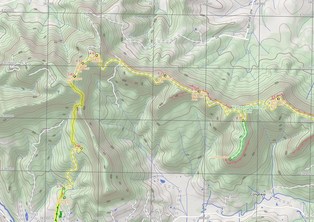
1 Congewai Track Head (East) to Watagan Headquarters 7 hrs Hard track 17.2 km One way 4 973m This full day walk starts from the Congewai valley trackhead (east) and follows the Great North Walk up into the Watagan National Park. Winding east along Georges road for the most part, this walk also passes many great lookouts and gives the option of a side trip down to the 125r lookout, which provides a great view to the south and nice spot for lunch. The walk finishes at the Watagan Headquarters campsite, which has a fire place and a picnic table. 513m 139m Watagans National Park Maps, text & images are copyright wildwalks.com Thanks to OSM, NASA and others for data used to generate some map layers.

2 Crawford Tank & Hut Before You walk This clearing is home to a water tank and hut on the 'Brown Muir' farm. The water tank was installed by LPMA in 2011 for walkers undertaking the Great North Walk. This farm and property have been in the owner's family since original land grants. You are welcome to camp here and use the hut as shelter. The hut is a simple structure with an earth floor, some tables, seating and some beds, although best to sleep in your tent. There is an old pit toilet on the side of the clearing. A sign reminds visitors not to light fires, this is a fuel stove only area. Wave and say hello to the owners Jill and Martin if you see them. Bushwalking is fun and a wonderful way to enjoy our natural places. Sometimes things go bad, with a bit of planning you can increase your chance of having an ejoyable and safer walk. Before setting off on your walk check 1) Weather Forecast (BOM Hunter District) 2) Fire Dangers (Greater Hunter) 3) Park Alerts (Watagans National Park) 4) Research the walk to check your party has the skills, fitness and equipment required 5) Agree to stay as a group and not leave anyone to walk solo Old Loggers Hut This Old Hut found beside Georges Rd, is in a state of disrepair. The corrugated iron and wooden hut has a dirt floor and a simple fire place. The hut's condition is poor and would not provide suitable shelter. Just south of the hut is a small dam. The hut was once used by loggers harvesting timber from these hills Georges Road Rest Area This campsite is located above Wallaby Gully, off Georges Road. The clearing has a scattering of trees, and has awesome views of Wallaby Gully. There is room for a few tents and small campfire. Barraba Campsite Barraba campsite, near Georges Road on the Great North Walk, is quiet rest area where campers can stay the night and set up a campfire. The small, semi-secluded campsite is surrounded by lovely large grass trees. The campsite has a 'Walker register' book so you can note your intentions. The campsite has no facilities or water. Saddle Rest Area This rest area consists of a clearing on a saddle, with a small dam nearby. There is space for a number of tents and access to water after rain (treat before use). Great North Walk Rest Area Located on George Road, this rest area is situated by a steep, unfenced drop with spectacular views. There is space for a few tents and a small campfire, there are no facilities or water here. Think before you TREK The 'Think before you TREK' program developed by NSW Police & NPWS promotes the benefits of planning ahead for your bushwalking trip by using an easy to remember acronym: adequate supplies of food, water, navigation and first T Take aid equipment. your planned route and tell friends and family when R Register you expect to return. beacon (PLB's) should be carried on walks with E Emergency significant gaps in mobile coverage (check terrain profile). to your planned route and follow the map and walking K Keep trails. Topo Maps The maps provided on wildwalks are helpful, but there are times where you may need maps covering a broader area. Maps that cover this walk include; 1: Map Series:91322S QUORROBOLONG 1: Map Series:91322 CESSNOCK 1: Map Series:9132 CESSNOCK Grade This walk has been graded using the AS The overall grade of the walk is dertermined by the highest classification along the whole track. 4 Grade 4/6 Hard track Length 17.2 km One way Time 7 hrs Quality of track Rough track, where fallen trees and other obstacles are likely (4/6) Signs Directional signs along the way (3/6) Experience Required Some bushwalking experience recommended (3/6) Weather Weather generally has little impact on safety (1/6) Infrastructure Limited facilities, not all cliffs are fenced (3/6)
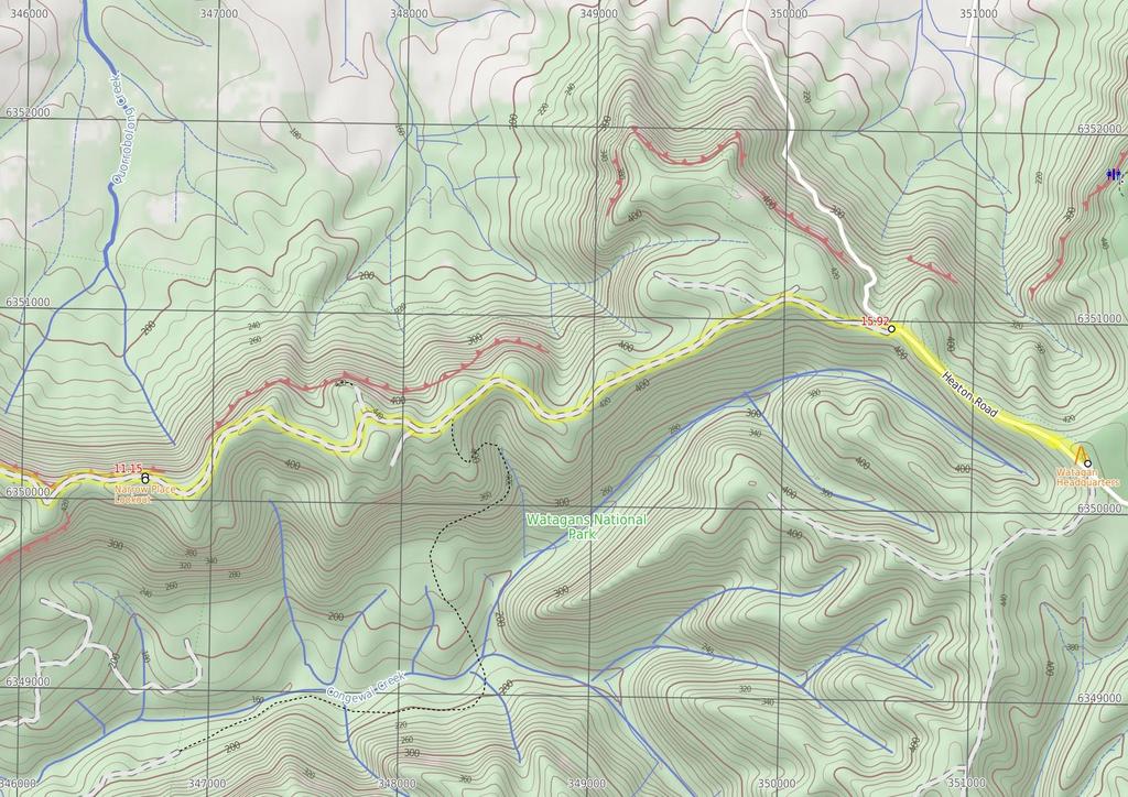
3 Are you ready to have fun? Please ensure you and your group are well prepared and equipped for all possible hazards and delays. Check park closures, weather information and Fire Danger Rating before setting out. Optional side trips and alternate routes noted are not included in this walks overall grade, length or time estimate. Please allow extra time for resting and exploring areas of interest. The authors, staff and owners of wildwalks take care in preparing this information but will not accept responsibility for any inconvenience, loss or injury you may experience. Please take care, have fun - Happy Walking. Getting there Traveling by car is the only practical way to get to Congewai Valley east trackhead (gps: , ). Car: There is free parking available. Traveling by car is the only practical way to get back from Forestry H.Q campsite (gps: , ). Car: There is free parking available. Find up to date and more information inlcuding; travel directions, weather, park closures and walker feedback at 0 Congewai Valley east trackhead (760 m 17 mins) From the Congewai Valley east trackhead, this walk follows the 'Newcastle' sign over the stile. Here the walk follows the track gently uphill through the open forest, leaving the Congewai Valley Road behind. After about 500m, this walk comes to a stile (with farmland and a fence on the left). Continue straight: From here, this walk climbs over the fence using the stile and follows the track gently uphill, keeping the more open farmland on your left. The walk continues for about 300m to an intersection with a wide dirt trail, just before a vehicular gate, marked with a GNW arrow post Optional sidetrip to Crawford Tank AND Hut (180 m 5 mins) Turn right: From the intersection, this walk follows the 'Drinking Water' sign up along the wide trail, away from the gate. The trail leads gently uphill for about 150m before coming to a large clearing with a hut and water tank. At the end of this side trip, retrace your steps back to the main walk then Veer right Crawford Tank & Hut This clearing is home to a water tank and hut on the 'Brown Muir' farm. The water tank was installed by LPMA in 2011 for walkers undertaking the Great North Walk. This farm and property have been in the owner's family since original land grants. You are welcome to camp here and use the hut as shelter. The hut is a simple structure with an earth floor, some tables, seating and some beds, although best to sleep in your tent. There is an old pit toilet on the side of the clearing. A sign reminds visitors not to light fires, this is a fuel stove only area. Wave and say hello to the owners Jill and Martin if you see them Property Gate (1.2 km 31 mins) Veer left: From the intersection, this walk follows the wide trail gently downhill and through the gate, and into the signposted 'Edwin Crawford Conservation Area'. The trail bends right, then starts to lead gently uphill for about 1.2km, until coming to a faint three-way intersection with a track (on the right), marked with a couple of GNW arrow posts Int on GNW bushtrack (1.9 km 54 mins) Turn left: From the intersection, this walk follows the GNW arrow post uphill. After about 700m, the track becomes narrower and much steeper as it climbs up to, then follows, the main ridge line. After about 600m of mostly steep climbing, the track then leads more gently uphill, enjoying the views through trees (on the right). The walk continues gently up this section for another 400m, then heads over a small rise and comes down to a T- intersection with the dirt Georges Road marked with a 'Great North Walk' sign. Turn right: From the intersection, this walk follows the GNW arrow marker gently downhill along the dirt road. After 80m, this walk passes a small dam and comes to an old tin hut (on the left) Old Loggers Hut This Old Hut found beside Georges Rd, is in a state of disrepair. The corrugated iron and wooden hut has a dirt floor and a simple fire place. The hut's condition is poor and would not provide suitable shelter. Just south of the hut is a small dam. The hut was once used by loggers harvesting timber from these hills 3.82 Old Loggers Hut (300 m 5 mins) Continue straight: From the old loggers hut, this walk follows the dirt road north-east along the top of the ridge, initially keeping the hut to your left. After about 300m, the trail leads to a large clearing with great views on the left, Georges Road rest area Georges Road Rest Area This campsite is located above Wallaby Gully, off Georges Road. The clearing has a scattering of trees, and has awesome views of Wallaby Gully. There is room for a few tents and small campfire Georges Rd rest area (320 m 6 mins) Continue straight: From Georges Road rest area, this walk follows the dirt road gently uphill, initially keeping the rest area on your left. The walk continues for about 200m until coming to a three-way intersection, marked with a GNW arrow marker. Continue straight: From the intersection, this walk follows the 'Barraba Trig Rest Area' sign north-east, gently uphill along the trail. Following a few GNW arrow markers over about 90m, this trail then comes to a large flat clearing signposted as 'Barraba campsite', with some lovely large grass trees Barraba Campsite Barraba campsite, near Georges Road on the Great North Walk, is quiet rest area where campers can stay the night and set up a campfire. The small, semisecluded campsite is surrounded by lovely large grass trees. The campsite has a 'Walker register' book so you can note your intentions. The campsite has no facilities or water Barraba Campsite (1.8 km 43 mins) Continue straight: From the Barraba campsite, this walk follows the 'Newcastle' sign east, downhill along the grassy trail. After about 220m, the walk heads past the 'Barraba Trig Rest Area' sign (pointing back uphill) to then climb the fence using the stile (beside the gate). Continue straight: From the locked gate, this walk heads downhill along the wide dirt trail, directly away from the 'Barraba Trig' sign. The trail leads down for about 400m, moderately steeply for a while. As the trail mostly flattens out, the walk climbs over another fence beside a locked gate using the stile. The walk continues down along this trail for almost 200m to pass 'The Barbara Lowes Conservation area' sign. Here, the walk climbs over the fence using the stile beside the vehicular gate. There are filtered valley views to your left. Continue straight: From the locked gate, this walk follows the trail gently downhill, while keeping the views on your left (and ignoring the trail on your left). This walk undulates gently up and down the side of the hill for about 1 km, until coming to a saddle, with views on the left and dam on the right Saddle Rest Area This rest area consists of a clearing on a saddle, with a small dam nearby. There is space for a number of tents and access to water after rain (treat before use) Saddle Rest Area (730 m 17 mins) Continue straight: From the saddle, this walk follows the trail gently uphill, initially keeping the views on your left and fire dam on your right. The walk continues with the cliffs on your right for just shy of 300m then after another 400m, just past the 'Private Property/Walkers Only' sign, this walk heads over the fence using a stile beside the gate. There are wide valley views from here, and a clearing on the left GNW Rest Area Located on George Road, this rest area is situated by a steep, unfenced drop with spectacular views. There is space for a few tents and a small campfire, there are no facilities or water here Int of Georges Rd AND Watagans National Park bound (1.3 km 33 mins) Continue straight: From the locked gate, this walk follows the dirt Georges Road moderately steeply downhill at first, keeping the views on your left. The walk undulates, moderately steeply in a couple of places, winding around the side of a few hills for about 1km, and then heads around a sharp left-hand bend (passing a faint roadside clearing, on the right). The walk continues for another 500m along the dirt road to come to a three-way intersection, with 125r trail and '125r Lookout' sign (on the right) Optional sidetrip to 125r Lookout Rest Area (860 m 17 mins) Veer right: From the intersection, this walk follows the '125r Lookout' sign south gently downhill along the grassy trail. The walk continues through forest for about 900m, until coming to the end of the road and an unfenced lookout with wide valley views. At the end of this side trip, retrace your steps back to the main walk then Turn right r Lookout The 125r Lookout, in the Watagan National Park, is located on a track off Georges Road. This unfenced clearing is on a cliff edge and has broad views o over the surrounding valleys. This small clearing has been used as a campsite Top of the 125r Lookout trail (1.3 km 31 mins) Veer left: From the intersection, this walk follows the GNW arrow marker east along Georges Road as it first bends left, initially keeping the 125r Lookout track on your right. After about 400m, the road leads down and across a flat saddle, then leads moderately steeply up for about 400m, where the trail mostly flattens out then comes to the top of the hill. There are views from the unfenced cliff here, on the left GNW Rest Area This is a small rest area on the side of Georges Road, providing room to rest up and for a small campfire. There are also some nice views through the trees but be careful as this rest area is near a steep drop Northern rest area (1.5 km 33 mins) Continue straight: From the rest area, this walk follows the dirt George Road east, initially keeping the views on your left. The road gently undulates along the ridge for about 1.5km, coming to the unsignposted Narrow Place Lookout, where there is a short metal post fence and wide valley (on the left) Narrow Place Lookout Narrow Place Lookout is perched high on an partially-fenced cliff and provides great views north over the farmland and bush towards Cessnock. The lookout is beside a dirt road and a fairly large clearing.
, marked with a GNW arrow post.")
4 11.15 Narrow Place Lookout (4.8 km 1 hr 32 mins) Continue straight: From the Narrow Place lookout, this walk follows Georges Road east gently downhill, initially keeping the views to your left. The road leads through forest for about 1.8km, ignoring a few smaller side trails until coming to a three-way intersection (with the Congewai Creek track, on the right), marked with a GNW arrow post. Continue straight: From the intersection, this walk follows the GNW arrow post east along the dirt Georges Road as it leads gently downhill, initially keeping the main valley to your left. The road leads along the ridge among the tall trees, past a few small clearings and side tracks for about 2.2km to pass a gate and timber fence (on your left). The walk continues along this main road for another 600m, coming to a T-intersection with the dirt Heaton Road, marked with a 'Watagans National Park' sign Int of Georges & Heaton Rds (1.2 km 25 mins) Veer right: From the intersection, this walk follows the 'The Great North Walk' sign gently uphill along the dirt Heaton Rd. The road leads up along the ridge through the tall forest for about 1.1km, until coming to a Yintersection with Bakers Rd and a large sign with many names. Veer left: From the intersection, this walk follows the 'Hunters Lookout' sign gently uphill along Bakers Road. The walk continues along this road for a bit over 150m, coming to a three-way intersection, just in front of the signposted 'Watagan Headquarters' campsite Watagan Headquarters Watagan Headsquarters campsite (aka Forestry HQ) is located in the Heaton State Forest, beside Bakers Rd, near Heaton Rd. This campsite has wood fired barbecues, picnic tables and a garbage bin. The large, flat, cleared area allows plenty of room to pitch a tent. In 2010, a series of vandalism attacks occurred on the water tank, so there is no longer water available.
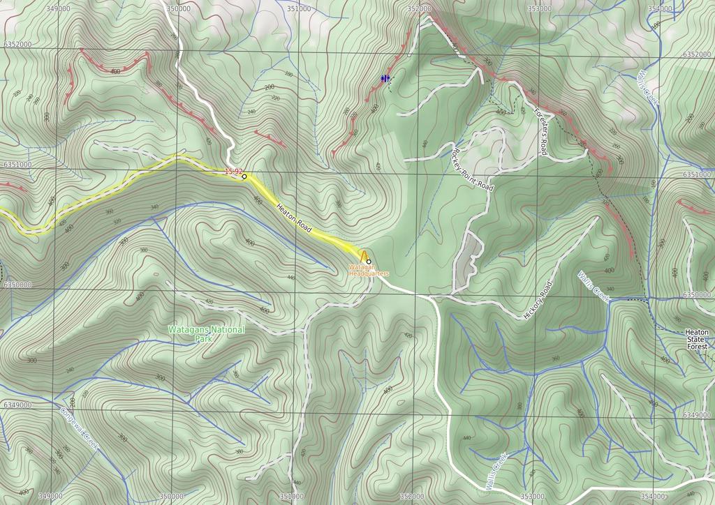
5
6
7
8 Summary navigation sheet for the Congewai Track Head (East) to Watagan Headquarters km From 0.00 Congewai Valley east trackhead , (GR Quorrobolong, ) Property Gate , (GR Quorrobolong, ) Property Gate , (GR Quorrobolong, ) Int on GNW bushtrack , (GR Quorrobolong, ) Old Loggers Hut , (GR Quorrobolong, ) Georges Rd rest area , (GR Quorrobolong, ) Barraba Campsite , (GR Quorrobolong, ) Saddle Rest Area , (GR Quorrobolong, ) Int of Georges Rd AND Watagans National Park boundary gate , (GR Quorrobolong, ) m 17 mins 180 m 5 mins 1.2 km 31 mins 1.9 km 54 mins 300 m 5 mins 320 m 6 mins 1.8 km 43 mins 730 m 17 mins 1.3 km 33 mins Top of the 125r Lookout trail , (GR Quorrobolong, ) 8.31 Top of the 125r Lookout trail , (GR Quorrobolong, ) 9.63 Northern rest area , (GR Quorrobolong, ) Narrow Place Lookout , (GR Quorrobolong, ) Int of Georges & Heaton Rds , (GR Quorrobolong, ) m 17 mins 1.3 km 31 mins 1.5 km 33 mins 4.8 km 1 hr 32 mins 1.2 km 25 mins Powered by TCPDF ( Up/Dwn Length Initial directions (Use full tracknotes and maps for more detail) From the Congewai Valley east trackhead, this walk follows the 'Newcastle' sign over the stile. Optional sidetrip to Crawford Tank AND Hut. Turn right: From the intersection, this walk follows the 'Drinking Water' sign up along the wide trail, away from the gate. Veer left: From the intersection, this walk follows the wide trail gently downhill and through the gate, and into the signposted 'Edwin Crawford Conservation Area'. Turn left: From the intersection, this walk follows the GNW arrow post uphill. Continue straight: From the old loggers hut, this walk follows the dirt road north-east along the top of the ridge, initially keeping the hut to your left. Continue straight: From Georges Road rest area, this walk follows the dirt road gently uphill, initially keeping the rest area on your left. Continue straight: From the Barraba campsite, this walk follows the 'Newcastle' sign east, downhill along the grassy trail. Continue straight: From the saddle, this walk follows the trail gently uphill, initially keeping the views on your left and fire dam on your right. Continue straight: From the locked gate, this walk follows the dirt Georges Road moderately steeply downhill at first, keeping the views on your left. Optional sidetrip to 125r Lookout Rest Area. Veer right: From the intersection, this walk follows the '125r Lookout' sign south gently downhill along the grassy trail. Veer left: From the intersection, this walk follows the GNW arrow marker east along Georges Road as it first bends left, initially keeping the 125r Lookout track on your right. Continue straight: From the rest area, this walk follows the dirt George Road east, initially keeping the views on your left. Continue straight: From the Narrow Place lookout, this walk follows Georges Road east gently downhill, initially keeping the views to your left. Veer right: From the intersection, this walk follows the 'The Great North Walk' sign gently uphill along the dirt Heaton Rd.
Nature Track. 900m. 789m. 2 hrs 3.1 km Circuit. Hard track 238m. Blue Mountains National Park
 Nature Track 2 hrs 3.1 km Circuit Hard track 238m Largely following the ridges around the top edge of Wentworth Falls, this track is incredibly beautiful. After taking in the great views at Edinburgh Castle
Abbotts Falls Walking Track
 Abbotts Falls Walking Track 3 hrs 7.3 km Circuit Hard track 329m This circuit takes you through both dry and moist forest, using a combination of walking trails and wider tracks. The side trip to the dammed
Staples Lookout to Mt Wondabyne loop
 Staples Lookout to Mt Wondabyne loop 4 hrs 3 mins 1.8 km Circuit Hard track 337m This walk starts and finishes at Staples Lookout, on Woy Woy Rd. The walk follows sections of the Great North Walk around
Berowra Waters to Cowan Station
 Berowra Waters to Cowan Station 3 hrs 30 mins 7.2 km One way Hard track 597m This is a hilly walk out of the beautiful Berowra Waters valley to Cowan Station. There are many wide views across Berowra Creek
Leura Cascades to Gordon Falls Reserve
 Leura Cascades to Gordon Falls Reserve 1 hr 15 mins 1.8 km One way Moderate track 200m From Leura Park to Gordon Falls Park, this diverse walk offers fantastic views of the Jamison Valley, as well as two
Mt Kuring-gai Track to Berowra station
 Mt Kuring-gai Track to Berowra station 4 hrs 15 mins 9.7 km One way Hard track 4 553m This walk explores three valleys, with great displays of wild flowers in spring, and some nice sandstone overhangs.
Merritts Traverse. 1928m
 Merritts Traverse 3 hrs Hard track 5.8 km Circuit 4 167m This walk starts with a scenic journey to the top of the hill on the chairlift. Starting along Merritts Nature walk, this walk soon detours down
Victoria Falls Lookout to Blue Gum Forest
 Victoria Falls Lookout to Blue Gum Forest 8 hrs Experienced only 13.8 km One way 5 112m This long day-walk follows a remote track down from Victoria Falls lookout, passing the waterfall, and into the Grose
Girrakool to Wondabyne station
 Girrakool to Wondabyne station 4 hrs Hard track 9.5 km One way 4 438m This walk starts from the Girrakool picnic area and winds south, through the Brisbane Waters National Park. The walk crosses some long
Erskine Creek via Pisgah Rock and Jack Evans
 Erskine Creek via Pisgah Rock and Jack Evans 4 hrs 30 mins 7.1 km Circuit Very experienced only 6 421m This walk visits some great lookouts and explores the lower section of Erskine Creek. Most of the
Guthega to Mt Twynam. 2183m. 1583m. 6 hrs 45 mins 14.8 km Return. Experienced only. 913m
 Guthega to Mt Twynam 6 hrs 45 mins 14.8 km Return Experienced only 5 913m This walk starts from Guthega and makes its way along the Snowy River to the Illawong Lodge, via the Blue Cow Creek flying fox.
Berowra to Cowan via Berowra Waters
 Berowra to Cowan via Berowra Waters 6 hrs Hard track 12.9 km One way 4 884m With train station at each end this walk explores the ridges and valleys around Berowra Waters. There are plenty of excellent
Crosslands to Berowra Waters return
 Crosslands to Berowra Waters return 6 hrs Hard track 13.7 km Return 4 1005m This return walk starts from the Crosslands Reserve and follows the Great North Walk along Berowra creek. The walk includes some
National Pass. 893m. 665m. 3 hrs 30 mins 4.6 km Circuit. Hard track 773m. Blue Mountains National Park
 National Pass 3 hrs 3 mins 4.6 km Circuit Hard track 773m 4 This walk offers fantastic views of the Jamison Valley and the surrounding cliffs. Take time to explore the historic and very scenic ledge halfway
Jerusalem Bay Track (Cowan to Brooklyn)
") Jerusalem Bay Track (Cowan to Brooklyn) 5 hrs 30 mins 13.4 km One way Hard track 4 654m This Cowan to Brooklyn Station walk is a popular section of the Great North Walk, with scenery ranging from foreshore
Jerusalem Bay Track (Cowan to Brooklyn) 5 hrs 30 mins 13.4 km One way Hard track 4 654m This Cowan to Brooklyn Station walk is a popular section of the Great North Walk, with scenery ranging from foreshore
Wentworth Pass. 893m. 535m. 4 hrs. Hard track 5.1 km Circuit. 692m
 Wentworth Pass 4 hrs Hard track 5.1 km Circuit 4 692m This walk offers a great way to explore the magical, upper section of the Valley of the Waters. The walk starts and finishes at Conservation Hut, which
Girrakool to Wondabyne station via Pindar caves
 Girrakool to Wondabyne station via Pindar caves 7 hrs 30 mins 18.1 km One way Experienced only 5 741m This walk starts from the Girrakool picnic area and winds south, following Piles creek into the Brisbane
Crosslands to Cowan. 220m
 Crosslands to Cowan 7 hrs 30 mins 14 km One way Hard track 4 1103m This section of the Great North Walk starts from the Crosslands camping area and winds north alongside Berowra creek, passing through
Dadder Cave and Jack Evans track
 Dadder Cave and Jack Evans track 2 Days 10.3 km Circuit Very experienced only 535m This fairly short overnight walk is a great way to explore Erskine Creek. The walking along Erskine creek is mostly off
Hornsby station to Crosslands
 Hornsby station to Crosslands 6 hrs 45 mins 16.1 km One way Hard track 4 938m This section of the Great North Walk starts from Hornsby train station and winds down along the Blue Gum Walk into Fishponds.
Scenic Railway to Ruined Castle
 Scenic Railway to Ruined Castle 7 hrs 30 mins 12.4 km Return Hard track 4 963m This is a very popular, full day walk, in the Katoomba Area, offering great views of the valley. The walk follows the edge
Somersby to Yarramalong via Stringy Bark Point
 Somersby to Yarramalong via Stringy Bark Point 2 Days Hard track 26.7 km One way 4 1201m This section of the Great North Walk starts form the Somersby General Store and follows the Great North Walk north
Gibberagong Track. 169m
 Gibberagong Track 2 hrs 30 mins 6.5 km One way Hard track 4 180m Starting in suburban Wahroonga, this wellmaintained track follows Cockle Creek down to Bobbin Head in the Ku-ring-gai Chase National Park.
Lady Carrington Drive
 Lady Carrington Drive 3 hrs 45 mins 9.7 km One way Moderate track 3 266m This walk follows the historic Lady Carrington Drive alongside the Hacking River. The old road is closed to traffic and provides
Somersby to the Basin Campsite
 Somersby to the Basin Campsite 3 Days Hard track 47.4 km One way 4 2032m This three day walk starts at the Somersby General Store and follows the Great North Walk, heading north, into the the Jilliby State
Main Range Track - Loop from Charlotte Pass camping near Mt Townsend
 Main Range Track - Loop from Charlotte Pass camping near Mt Townsend 2 Days Experienced only 27.7 km Circuit 5 1260m This great overnight walk starts from Charlotte Pass and provides access to some of
Main Range Walk - Charlotte Pass to Mount Kosciuszko
 Main Range Walk - Charlotte Pass to Mount Kosciuszko 9 hrs Hard track 21.9 km Circuit 4 920m This full day walk explores some of the greatest alpine country on offer in NSW. The walk grants views of Blue,
Victoria Falls and Grose Valley to Blackheath Station
 Victoria Falls and Grose Valley to Blackheath Station 3 Days Experienced only 22.5 km One way 5 158m This walk explores a fantastic section of the Grose Valley. Starting above Victoria Falls, the walk
Patonga to Staples Lookout
 Patonga to Staples Lookout 6 hrs 3 mins 17 km One way Hard track 4 72m This great walk explores much of the main ridge ridge running through Brisbane Water National Park. The walk visits a number of great
Victoria Falls to Blackheath Station
 Victoria Falls to Blackheath Station 2 Days Experienced only 22.2 km One way 5 1561m This is a fantastic overnight walk with a sleep in Acacia Flats camping area. The Grose Valley, with its views of the
Berowra to Hornsby. 9 hrs 18 mins 22.6 km One way. Hard track. 1423m
 Berowra to Hornsby 9 hrs 18 mins 22.6 km One way Hard track 4 1423m One of the longer day walks in Berowra Valley National Park, this walk mostly follows Berowra Creek along the Great North Walk. Excellent
Patonga to Wondabyne station via Mt Wondabyne
 Patonga to Wondabyne station via Mt Wondabyne 7 hrs 3 mins 19.5 km One way Hard track 4 861m This walk explores some grand views, pleasant cascades, varied bushland and remote areas of Brisbane Waters
Wondabyne station to Somersby Store
 Wondabyne station to Somersby Store 10 hrs Hard track 26.2 km One way 4 1164m This walk, following a section of the Great North Walk, starts from the Wondabyne train station and winds north, into the Brisbane
Crosslands to Brooklyn
 Crosslands to Brooklyn 2 Days Hard track 27.4 km One way 4 1757m From the Crosslands Reserve, this walk heads along the Great North Walk via Berowra Waters, Cowan, Jerusalem Bay and onto Brooklyn. This
Blackheath to Blue Gum loop
 Blackheath to Blue Gum loop 2 Days Hard track 24.1 km Circuit 4 1335m This walk is great for fit people getting into overnight walking, with its fantastic scenery and nostalgia as a classic overnighter.
Guthega to Thredbo camping overnight at Wilkensons Creek
 Guthega to Thredbo camping overnight at Wilkensons Creek 2 Days Experienced only 25.8 km One way 5 1364m This great overnight walk explores the Kosciusko National Park between Guthega and Thredbo, visiting
Leura to Katoomba via Dardanelles Pass
 Leura to Katoomba via Dardanelles Pass 4 hrs 6.6 km One way Hard track 697m With approximately equal parts cliff-walk and forest track, this track truly shows what the cliff edges of the Jamison Valley
Patonga to Wondabyne station via Pindar Caves overnight
 Patonga to Wondabyne station via Pindar Caves overnight 2 Days Experienced only 28.1 km One way 5 1164m This overnight hike starts from Patonga beach and winds along a section of the Great North Walk,
Cowan to Wondabyne station via Patonga rest area
 Cowan to Wondabyne station via Patonga rest area 2 Days Hard track 33.4 km One way 4 1523m This section of the Great North Walk starts from Cowan train station and wanders past the majestic Jerusalem Bay
Western Commission Track to Dubbo Gully
 This two day walk follows a series of historic roads along clear and wide management trails. This walk explores the great views from Western Commission Track, the sandstone handicraft on the Old Great
Katoomba to Wentworth Falls via the Jamison Valley
 Katoomba to Wentworth Falls via the Jamison Valley 2 Days Experienced only 29.2 km One way 5 2135m This is the two day version of this popular and challenging walk. This walk passes popular sights including
The Prince Henry Cliff Walk
 The Prince Henry Cliff Walk 3 hrs 30 mins 6.8 km One way Moderate track 3 575m Going from Katoomba to Leura, this walk covers the top of the cliff line and most of the major lookouts. With brilliant vistas
Main Range Circuit from Guthega
 Main Range Circuit from Guthega 4 Days Experienced only 45 km Circuit 5 2317m This four day walk explores the Kosciuszko National Park, covering many of the key features of the park between Guthega and
Thornleigh to Cowan. 2 Days. Hard track 35.9 km One way. 2337m
 Thornleigh to Cowan 2 Days Hard track 35.9 km One way 4 2337m Following the Great North Walk and Berowra Creek through Berowra Valley Regional Park, this walk cuts straight through the length of the Park.
Gordon to Hornsby (overnight at Scout camp)
") Gordon to Hornsby (overnight at Scout camp) 2 Days Hard track 25.8 km One way 4 125m This overnight walk starts from Gordon train station and winds through bush filled valleys to Hornsby station. From
Gordon to Hornsby (overnight at Scout camp) 2 Days Hard track 25.8 km One way 4 125m This overnight walk starts from Gordon train station and winds through bush filled valleys to Hornsby station. From
Victoria Falls and Grose Valley to Blackheath Station
 This walk explores a fantastic section of the Grose Valley. Starting above Victoria Falls, the walk explores the cascades before dropping into the valley for the first nights rest at Burra Korain campsite.
COLOUR G U I D E. Sydney to Newcastle: Australia s most accessible long-distance walk
 COLOUR G U I D E Sydney to Newcastle: Australia s most accessible long-distance walk Woodslane Press Pty Ltd Unit 7/5 Vuko Place Warriewood, NSW 2102 Australia Email: info@woodslane.com.au Tel: (02)
Out and about at Geehi
 Geehi Geehi Flats is a large area of flat floodplain on the banks of the Swampy Plains River. Located within Kosciuszko National Park, it is home to a popular campsite in summer for people wanting to enjoy
Hindhead, Keffolds Copse and Gibbet Hill
 point your feet on a new path, Keffolds Copse and Gibbet Hill Distance: 6 km=4 miles Region: Surrey Author: Schwebefuss Refreshments: Punch Bowl Café moderate walking Date written: 14-apr-2015 Last update:
GOLDEN EARS PROVINCIAL PARK
 GOLDEN EARS PROVINCIAL PARK Trail Information as of October 10 th 2015 Do not underestimate the mountainous wilderness of Golden Ears Provincial Park. The combination of rugged terrain and rapidly changing
Slad over to Pitchcombe and back
 The walk climbs up from Slad over Wickridge Hill, descends to near Pitchcombe, then climbs back over Wickridge hill and round the back of Slad. Page 1 Start Point: SO 8718 0732 The Woolpack, Slad Length:
The Mendip Way. Route Directions and Maps Uphill to Wells
 The Mendip Way Route Directions and Maps Uphill to Wells Website: www.mendiphillsaonb.org.uk Email: mendip@mendiphillsaonb.org.uk Facebook & Twitter: @MendipHillsAONB Phone: 01761462338 1 Uphill to Loxton
Beautiful Walks from the Blue Ball Inn
 Walk No. 5 RIVER VALLEYS AND MOOR Countisbury, Watersmeet, Hillsford Bridge, Cheriton, Shilstone Hill, Rockford and Chiselcombe. 8.5 MILES APPROX. Walking time four and a half hours approx. OS 1;25,000
Leaden Boot Challenge ROUTE INSTRUCTIONS
 Leaden Boot Challenge ROUTE INSTRUCTIONS Section 1 Alstonefield to Ilam From the village hall car park turn R then L and pass through the village keeping to the R to enter Church Street. Pass the Church
CWMGIEDD FROM ABERCRAVE
 Abercrave to Cwmgiedd Walk Page 1 Starting from The Abercrave Inn. Grid Ref: SN 824128 From the Abercrave Inn, an 11.3km (7 miles) walk to the foothills of the Cribarth Mountain, then through forest to
Leaden Boot Challenge 2016 ROUTE INSTRUCTIONS
 Leaden Boot Challenge 2016 ROUTE INSTRUCTIONS Section 1 Alstonefield to Ilam (CP2) From the village hall car park turn R then L and pass through the village keeping to the R to enter Church Street. Pass
Tiger Mountain State Forest:
 98 60 hikes within 60 miles: SEATTLE 20 Tiger Mountain State Forest: West Tiger Mountain Three Loop i KEY AT-A-GLANCE INFORMATION Length: 5.1 miles round-trip Configuration: Loop Difficulty: Moderate difficult
IRON BARK and COLENSO HUTS 260 Series Map: 1:50, U21 NZ Grid GPS: Geodetic Datum 1949
 IRON BARK and COLENSO HUTS 260 Series Map: 1:50,000 260-U21 NZ Grid GPS: Geodetic Datum 1949 Topo50 Map: BK36 Taoroa Junction GPS: on WGS84 How to get to START: Exit Taupo on SH1 down the lake to Turangi
Self-Guided Walk Langdale Pikes. Start & Finish: NT car park (free to members) at Sticklebarn - on the right just beyond the New Dungeon Ghyll hotel.
 at Sticklebarn - on the right just beyond the New Dungeon Ghyll hotel.") Self-Guided Walk Langdale Pikes Key Information These mountains form a collection of spires and cliffs on the north side of Langdale. This walk visits four of the main tops Pavey Ark, Harrison Stickle,
Self-Guided Walk Langdale Pikes Key Information These mountains form a collection of spires and cliffs on the north side of Langdale. This walk visits four of the main tops Pavey Ark, Harrison Stickle,
Bewl Water & the High Weald
 1 Bewl Water & the High Weald Stonegate station - Stonegate - Wallcrouch - Newbarn - Cousley Wood - Wood's Green - Wadhurst station Length: 9 ½ miles (15.3km) Underfoot: Large portions of this path are
ID: 283 Distance: 6.2 miles Height gain: 500 Metres Map: Explore OL 19 Contributor David and Chris Stewart
 Walkingworld Wild Boar Fell ID: 283 Distance: 6.2 miles Height gain: 500 Metres Map: Explore OL 19 Contributor David and Chris Stewart Features Birds, Great Views, Hills or Fells Description: Wild Boar
1. Waterfall Gully Mt Lofty. 5 Of the Best Hikes in Adelaide
 Adelaide is a beautiful city, and one of the most incredible things about Adelaide is the quality of bushwalking available on the suburban fringe. It is surrounded by the Mt Lofty Ranges, and much of the
Singleton and the South Downs
 point your feet on a new path Singleton and the South Downs Distance: 13½ km=8½ miles easy walking with a few steeper sections Region: West Sussex Author: Hautboy Refreshments: Singleton, Hill Barn Date
East West route and Leatham Molesworth route (route guide) Molesworth Recreation Reserve
 Molesworth Recreation Reserve") East West route and Leatham Molesworth route (route guide) Molesworth Recreation Reserve 0BIntroduction The East West route links the Clarence (Kahutara River in Ka Whata Tu o Rakihouia) Conservation Park
East West route and Leatham Molesworth route (route guide) Molesworth Recreation Reserve 0BIntroduction The East West route links the Clarence (Kahutara River in Ka Whata Tu o Rakihouia) Conservation Park
Wicklow Mountains Path Survey
 Wicklow Mountains Path Survey Ballinacor Croaghanmoira Fananierin Start to Finish: T 11723 86602 to T 11175 89057 Altitude (lowest highest): 385m 664m Weather: Hot Access: Coolgarrow forest entrance Surveyed
WORDS BY LUKE ARNOLD, PHOTOGRAPHY BY MATT HAWKE
 Southern SECRETS The scenery, history and 4WDing of this lesser-known region of the Victorian High Country will blow you away WORDS BY LUKE ARNOLD, PHOTOGRAPHY BY MATT HAWKE 038 038-043 Sth Alpine.indd
HEYSEN TRAIL MINIBUS SHUTTLE SERVICES
 HEYSEN TRAIL MINIBUS SHUTTLE SERVICES BOOKINGS ARE ESSENTIAL CONTACT US FOR CURRENT PRICES, QUOTES & AVAILABILITY phone or SMS 0488 705 224 email post PO Box 235 Yankalilla SA 5203 We offer two types of
Telluride-to-Moab Alternative Singletrack Options
 Telluride-to-Moab Alternative Singletrack Options Day 1 Day 1 Alternate 1: Galloping Goose to Deep Creek. 18.4 miles, ascent 3,530ft, descent 1,388ft. This is fun, flowey, moderate to intermediate singletrack
Our Murray River Beaches
 Page 1 of 5 Our Murray River Beaches Click here to print this page West of Yarrawonga are many access points to the river. Earth tracks lead from the Murray Valley Highway through state forests to picnic
Ardingly Lake, Ouse Valley, Borde Hill
 point your feet on a new path Ardingly Lake, Ouse Valley, Borde Hill Distance: 14 km=9 miles or 12½ km=8 miles Region: West Sussex Author: Hautboy Refreshments: Borde Hill Map: Explorer 135 (Ashdown Forest)
Camp Jack Wright PERMANENT ORIENTEERING COURSE (2004)
") Camp Jack Wright PERMANENT ORIENTEERING COURSE (2004) WHAT IS ORIENTEERING? The skill which enables a person to navigate with a map. In the competitive sport, the winner is the person who finishes in the
Camp Jack Wright PERMANENT ORIENTEERING COURSE (2004) WHAT IS ORIENTEERING? The skill which enables a person to navigate with a map. In the competitive sport, the winner is the person who finishes in the
HARDMOORS 55 RACE ROUTE 2018 HELMSLEY - GUISBOROUGH
 HARDMOORS 55 RACE ROUTE 2018 HELMSLEY - GUISBOROUGH HELMSLEY - CHECKPOINT 1 (WHITE HORSE) 1. Leave RACE START, continue ahead on road (Baxtons Sprunt) At crossroads turn right down Canons Garth eventualy
Pontfadog. Walk A. Walk A
 Walk A A Bird s eye view of the village 2km. (1 1 /2 miles); height gain 45m. (150ft) about 45 minutes. Six minutes walk along the main road towards Glyn Ceiriog reach a signpost to Llwynmawr. Take the
Walk 1. Cotswold Water Park. Gateway Centre to Cerney Wick, railway track to Lake 6, Gateway Centre.
 Cotswold Water ark Walk way A Swindon/ Cirencester Thomas and Severn Canal way to Cerney Wick, railway track to Lake, way. Spine Road East Hotel Time: hours (short walk km) Distance: km A level walk along
Reigate Hill and Gatton Park
 point your feet on a new path Reigate Hill and Gatton Park Distance: 11½ km=7 miles easy-to-moderate walking or 2 walks of 6½ km=4 miles and 5½ km=3½ miles Region: Surrey Author: Schwebefuss Refreshments:
Baggy Point, Croyde, North Devon
 Baggy Point, Croyde, North Devon A walk using the South West Coast Path that is likely to be suitable for people with impaired mobility or with a pushchair, wheelchair, or mobility scooter. The Coast Path
A Circular Walk from Chapel Carn Brea
 A Circular Walk from Chapel Carn Brea 4.3 Miles A Walk Visiting Five Historic Ancient Sites This circular walk offers the possibility of several alternatives, depending on the walker s available time and
Sponsored by. statestreet.com
 /STATESTREETISLANDWALK #ISLANDWALKJSY Sponsored by statestreet.com Important Information If you forget everything else PLEASE remember the following.» Remember to check OUT of every checkpoint» If you
Ystwyth and Rheidol Bridleway Routes. Route 2:Llanilar Circular
 Ystwyth and Rheidol Bridleway Routes Route 2:Llanilar Circular Route overview and terrain: A long circle using connecting ridges with fine views to link the Rheidol and Ystwyth river valleys. The route
Fetcham Downs and Bocketts Farm A magical teashop walk
 point your feet on a new path Fetcham Downs and Bocketts Farm A magical teashop walk Distance: 3 km=2 miles or 4 km=2½ miles Region: Surrey Author: Fusszweig Refreshments: Bocketts Farm easy walking Date
Around and about Geraldine
 Around and about Geraldine A guide to recreational opportunities SOUTH CANTERBURY Track classifications Short walk Easy walking for up to an hour Track is well formed, with an even, welldrained surface.
Walking Track Classification System Parks and Wildlife Service
 Appendix A Walking Track Classification Specifications Walking Track Classification System Parks and Wildlife Service This Walking Track Classification System is the outcome of a review of the track classifications
Map: Landranger #27 Forres and Nairn and 36 Grantown and Aviemore
 THE DAVA WAY This is a newly created long distance route that runs from Forres to Grantown, mostly following the old railway line. You will need to detour around a couple of sections that are not really
Marilla Reservoir to Chestnut Ridge via Marilla Trails and Bullis Hollow Trail east to west
 USGS topographic maps useful to this hike are the Bradford and Stickney 7.5 minute sectionals. These notes are designed to assist in identifying distance and location using geophysical and man-made characteristics
BURGHCLERE PARISH RIGHTS OF WAY
 BURGHCLERE PARISH RIGHTS OF WAY Full descriptions compiled by Neill & Miggie Bruce All photos Miggie Bruce FP23 on Ridgemoor, looking south, with FP22 crossing by the bush FP1. From C183 Aldern Bridge
Printed in China by Designed by Coral Lee Main cover image: Broken Bay
 Woodslane Press Pty Ltd Unit 7/5 Vuko Place Warriewood, NSW 2102 Australia Email: info@woodslane.com.au Tel: (02) 9970 5111 Fax: (02) 9970 5002 http://travelandoutdoor.bookcentre.com.au First published
Britain s oldest surviving water-balanced cliff lift
 44 3.6 Saltburn by the Sea to Sandsend Map panels 3 and 4 Distance 17 miles (27½ km) Terrain mostly grass and field paths which can be muddy; some pavement, beach and shore Grade undulating route, with
Trail Phasing Plan. Note: Trails in the Clear Creek Canyon area (Segments will be finalized in the future to minimize wildlife impacts
 Note: Trails in the Clear Creek Canyon area (Segments 2 5 and a future JCOS connection) will be finalized in the future to minimize wildlife impacts Trail Phasing Plan P Parking 3 Easy Trail Intermediate
Listing of Campsites on the Manigotagan River
 Listing of Campsites on the Manigotagan River This document lists and describes the campsites along the Manigotagan River between Highway #314 and the government dock in the community of Manigotagan. The
Route #2) Mt. Massive - Southwest Slopes
 Mt. Massive - Southwest Slopes") Route #2) Mt. Massive - Southwest Slopes Difficulty: Class 2 Ski: Advanced, D6 / R2 / III Exposure: Summit Elevation: Trailhead Elevation: Elevation Gain: Round-trip Length: Trailhead: County Sheriff:
Route #2) Mt. Massive - Southwest Slopes Difficulty: Class 2 Ski: Advanced, D6 / R2 / III Exposure: Summit Elevation: Trailhead Elevation: Elevation Gain: Round-trip Length: Trailhead: County Sheriff:
Kakadu Highlights No. 9: September 23 - October 6, 2018
 Kakadu Highlights No. 9: September 23 - October 6, 2018 Section 1: Barramundi Creek: September 23-26 We begin with a four to six hour, 350 kilometre drive from Darwin. The last 45 kilometres is on a 4WD
beach. Make the ford and follow the trail out to the junction with Red Creek Tr in an open grassy area.
 Description: This is a moderate to slightly strenuous 22.8 mile backpack (add 2.6 miles if you do the packless out and back to the Lion s Head) that will have you exploring nearly every thing that is The
Countryside Trails Dunkeld
 R A N G E R S E RV I C E Countryside Trails Dunkeld WELCOME Welcome to this southern end of Atholl Estates. The countryside here is a wonderful blend of lochs, woodland and heather moor. There is a large
Hiking Trail Descriptions
 Hiking Trail Descriptions For ye shall go out with joy. And be led forth with peace. The mountains and the hills shall break forth before you in singing. And all the trees of the fields shall clap their
This area is a popular holiday spot so watch out for 4WD vehicles and motorbikes at peak times.
 Mavora Walkway (Map 130, 129, 128) Southern Start Northern End Distance Time Track Standard Mavora Camping Area, Mavora Lakes Road Greenstone Station Road Carpark 50km 3 days Tramping track Hazards Never
Access. Road from start point (W01) to campground (W56) Water Taxi Pick-up (W03)
 to campground (W56) Water Taxi Pick-up (W03)") WAIKAREMOANA GREAT WALK 260 Series Map: W18 Waikaremoana NZ Grid GPS: Geodetic Datum 1949 Topo50 Maps: BG39 Ruatahuna & BG40 Waikaremoana Gaps: on WGS84 Topo250 Map: Sheet 10 To get to START: Exit Taupo
WAIKAREMOANA GREAT WALK 260 Series Map: W18 Waikaremoana NZ Grid GPS: Geodetic Datum 1949 Topo50 Maps: BG39 Ruatahuna & BG40 Waikaremoana Gaps: on WGS84 Topo250 Map: Sheet 10 To get to START: Exit Taupo
C E N T R A L C A T S K I L L S
 120 C E N T R A L C A T S K I L L S Central Catskills Once out of the southern parts of the Catskills, the Long Path enters the more well traveled and civilized regions. The trail joins the Devil s Path,
BISHOPSTONE CIRCULAR WALK
 BISHOPSTONE CIRCULAR WALK 4½ miles (7¼ km) - allow 2 hours (see maps on final pages) Introduction This walk is within the North Wessex Downs Area of Outstanding Natural Beauty and starts from the small,
Section 7: Pick Up Where You Left Off! S-Tree Road over the Todd Road
 2018 TRACE NOTES Helpful information for your adventure on Section 7 of the Hiker Challenge. Start Point S-Tree Rd. End Point Intersection Todd Rd. / Hale Ridge Rd. WEATHER DECISION Weather Alert!!!! Potential
Ala-Kul trekking guide.
 Ala-Kul trekking guide. The marshrutka 101 brings you to the entrance of the park. For 400 KGS, a taxi will stop between the entrance and the broken bridge, saving at least 1 hour of walk. Download me