Cherokee Hiking Club Trail Blurb
|
|
|
- Martin Marsh
- 5 years ago
- Views:
Transcription
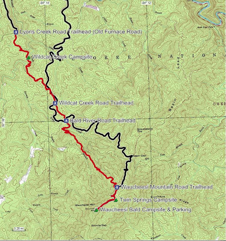
1 Cherokee National Forest Trail #164 Distance: 6.2 miles Elevation Change: 2280 feet High Point: 3692 feet (Waucheesi Mountain) Low Point: 1412 feet (Wildcat Creek) Trail Rating: Moderately Strenuous (NW to SE) or Moderate (SE to NW) (please refer to our trail difficulty rating system on our website) Parking: A shuttle is recommended. Leave one car on Lyons Creek Road (AKA Old Furnace Road) at the west end of the trail and then drive to the top of Waucheesi Mountain and park on the bald with the radio tower near the primitive campsite. Driving Directions to the Lyon s Creek Road (Old Furnace Road) Trailhead: From the Tellico Ranger Station, drive west toward Tellico Plains on the Tellico River Road 0.5 miles to the Cherohala Skyway, then follow the Skyway west for 3.0 miles, then turn left onto Lyons Creek Road (FS 76) (AKA Old Furnace Road) across the Cherohala Skyway from the Tellico Beach Drive In. On some maps this road is labeled as Old Furnace Road and the sign along the Skyway is labeled Old Furnace Road as well. From TN 68, this intersection is 2.2 miles east up the Skyway (TN 165). Follow FS 76 for 3.0 miles to a sign which marks the start of the trail. There is not much parking available at the Lyons Creek Road Trailhead, but there are some good pullovers a short way down the road past the trailhead. Just find a suitable spot which allows other cars to easily pass. Driving Directions to Waucheesi Bald Trailhead: From the Tellico Ranger Station, drive directly across the Tellico River Road over the bridge onto Wildcat Creek Road (FS 384) for 6.1 miles to a left turn onto the Bald River Road (FS 126). Follow Bald River Road 2.8 miles to Basin Gap. Make a sharp right onto the Waucheesi Mountain Road (FS 126C) and follow this road 1.7 miles to the top of the mountain. This is a narrow steep gravel road with sharp turns. Parking at the top is ample in the open bald near the site of the old firetower. On the site of the firetower is now a microwave repeater tower. This area is often used by campers or hikers on the Benton MacKaye Trail which is accessed a half mile south of the bald down the south slope of the mountain. The BMT is a 300 mile long distance hiking trail from Springer Mountain in Georgia (the start of the Appalachian Trail) to the north end of the Smokies and is maintained by the Benton MacKaye Trail Association ( While driving from the ranger station to Waucheesi Bald, you cross the Warrior s Passage Trail twice, on Wildcat Road 5.6 miles from the Tellico River, and on the Bald River Road 0.2 miles from the left turn off Wildcat Road onto Bald River Road. Also, the trail intersects the Waucheesi Mountain Road 0.9 miles from Basin Gap, just 0.8 miles from the bald. There is no good parking where the trail meets this road. Thus we recommend you start your hike at the top of the bald and hike the 0.8 miles down the road to where the trail leaves the road. This also affords you excellent views off the side of Waucheesi Mountain from the bald and along the road down to the trail intersection.
2 Trail Description: From the bald, hike 0.8 miles down the Waucheesi Mountain Road to where the trail leaves the road. The bald itself and the hike down the road offers majestic views of the surrounding mountain ridges, many of which exceed 5000 feet in elevation. At mile 0.8, leave the road down a steep slope off the edge of the road to the left. A post with the Warrior s Passage symbol marks the start of the trail. The trail quickly levels out and descends the steep slope of the mountain in a series of switchbacks in mature hardwoods. At mile 1.5, the trail enters an area of pine recovery after a forest fire in the late 1990s; thus the trees recovering are over 10 years old and are growing very densely. The trail forms a tunnel through this dense pine foliage. Many old dead pine trees are still standing and you may have to cross over some of these trees if high winds have knocked them down since the last trail maintenance. At mile 1.8, you again enter a mixed pine and hardwood forest down a steep ridgeline between Tobe Creek on your right and Rocky Branch on your left. At mile 2.1, you reach Mule Pen Gap and cross a gated forest service road right by the gate. From here you skirt along the north side of a ridge then travel down the ridgeline to a crossing over Tobe Creek at mile 3.3. At mile 3.6 you cross Bald River Road and head uphill through another heavily burned over area of more recent vintage. These areas of forest were burned over in the late 90 s. These areas afford great views and an opportunity to see a forest recovering after a fire. These fires caused closure of the trail until 2008 when the trail was reopened after many hours of labor by volunteers. After crossing the ridgeline, the unburned forest returns and the trail heads downhill to cross over Wildcat Creek Road at mile 4.0. The trail heads more or less north for a ways, somewhat paralleling the road, then leaves the road and heads downhill to Wildcat Creek. Cross Wildcat Creek at mile 5.3. In high water this crossing may be difficult and dangerous since this is a fairly large but beautiful creek. Expect to get your feet wet even at times of low water. There is an excellent campsite on the west side of the creek. Follow the trail to its end uphill to the Lyons Creek (Old Furnace) Road at mile 6.3. Camping: Three excellent campsites are along the trail. The first is on top of Waucheesi Mountain. This is an open grassy field with a 360 degree view of the surrounding mountains. No water is available. In times of inclement weather, care should be exercised due to the exposure of the site. High winds and lightning are possible. The second is Twin Springs Campsite a short ways down the Waucheesi Mountain Road from the bald at the first switchback. This site is wooded with an excellent spring just to the east of the campsite. The third is on the west side of Wildcat Creek. Water is readily available from the creek. Camping is also possible along Tobe Creek, but there is no established campsite. Pack out your trash. Please pick up trash left by others as well. Wash dishes at least 100 feet away from running water. No soap in the creek. Use cat holes. Be sure fires are completely out before leaving the site. Water: Water is available at Tobe Creek and Wildcat Creek as well as the spring at Twin Springs Campsite. Water should be sterilized. Cell phones: Cell phone service is spotty in the Tellico Ranger District of the Cherokee National Forest, but good service is available in Tellico Plains. Emergency is History of the Trail: This trail was first designed and constructed by Boy Scouts and Scouters from the Great Smoky Mountain Council, BSA (Knoxville, TN) in The trail fell into disuse in the late 1990s after fires destroyed much of the trail corridor. The trail was reopened back up in 2008 and is now maintained by CNF volunteers. The trail follows what is believed to be one of the routes used by the Cherokee to cross the mountains. There were many Warrior s Passages across the Appalachian Mountains and several became pioneer routes, then later became established roads and trail corridors. Trail Maintenance: This and other trails in the Tellico Ranger District of the Cherokee National Forest are maintained by volunteers. If you would like to volunteer, contact the Tellico Ranger Station at (250 Ranger Station Road, Tellico Plains, TN 37385, lesliemsmith@fs.fed.us). If you see something which needs the attention of the trail maintainers, please contact the ranger station. Updated January 8, 2009 This trail blurb was developed by the Cherokee Hiking Club, 2359 Varnell Road, Cleveland, TN For more information, check out our website at
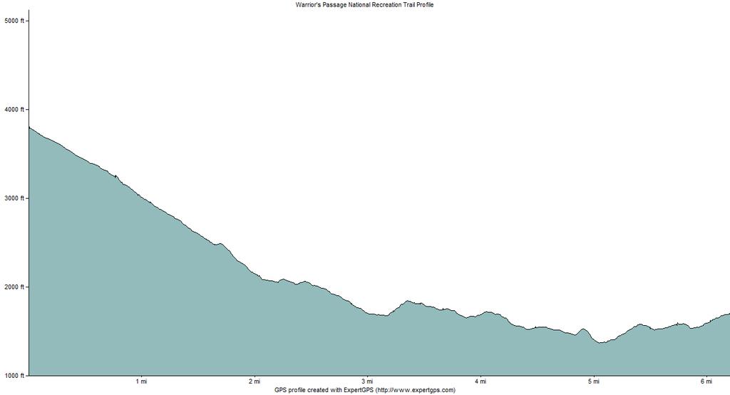
3 Profile
4

5 Road Access Map
ROAD SCHOLAR SPRING HIKING ADVENTURE Tentative Schedule April 9-14, 2017
 ROAD SCHOLAR SPRING HIKING ADVENTURE Tentative Schedule April 9-14, 2017 Sunday, April 9 PM 3:00-5:00 Arrival, registration and move in to the dorm. 6:00 Supper EVE 7:15 Welcome & Orientation, Sign Ups
Trail Phasing Plan. Note: Trails in the Clear Creek Canyon area (Segments will be finalized in the future to minimize wildlife impacts
 Note: Trails in the Clear Creek Canyon area (Segments 2 5 and a future JCOS connection) will be finalized in the future to minimize wildlife impacts Trail Phasing Plan P Parking 3 Easy Trail Intermediate
ROAD SCHOLAR SPRING HIKING ADVENTURE Tentative Schedule April 8-13, 2018
 Sunday, April 8 ROAD SCHOLAR SPRING HIKING ADVENTURE Tentative Schedule April 8-13, 2018 PM 3:00-5:00 Arrival, registration and move in to the dorm. 6:00 Supper EVE 7:00 Welcome & Orientation, Sign Ups
Lava Mountain Trail Distance: Elevation Range: Trail Type: Difficulty: Season: Driving Distance: Driving Time: USGS Maps: Pros Cons
 Lava Mountain Trail Distance: 13.4 miles (including the side trip to North Star Lake) Elevation Range: 5900'-8330' Trail Type: singletrack Difficulty: moderate Season: late June-October Driving Distance:
GREAT SMOKY MOUNTAINS FAMILY CAMP!
 GREAT SMOKY MOUNTAINS FAMILY CAMP! July 10-15, 2017 SCHEDULE OF EVENTS Monday PM 3:00-5:00 EVE 5:45 WELCOME! Arrival, registration and move in to the dorm. Supper 6:45 Welcome & Orientation & Sign Up for
Trail Beginning Elevation: 7553 ft The Poison Creek Trailhead is located at the end of National Forest Road 646E (NF-646E).
.") West Mountain Trails Poison Creek Trail #134 Length: 2.9 miles (4.7 km) Difficulty Horseback: A good trail for the first time west mountain rider, some steep sections Hiking: Most Difficult USGS Maps:
West Mountain Trails Poison Creek Trail #134 Length: 2.9 miles (4.7 km) Difficulty Horseback: A good trail for the first time west mountain rider, some steep sections Hiking: Most Difficult USGS Maps:
The Cherokee Hiker. September 2010 Volume 26, Issue 9. Cherokee Hiking Club, Inc Varnell Road Cleveland, TN
 The Cherokee Hiker September 2010 Volume 26, Issue 9 ~CHC Hike Calendar~ Cherokee Hiking Club, Inc. 2349 Varnell Road Cleveland, TN 37311 www.cherokeehikingclub.org September 11, 2010 Saturday. Bob Bald/Hangover
Route #1) Mt. of the Holy Cross - North Ridge
 Mt. of the Holy Cross - North Ridge") Climbing 14ers can be very dangerous, please read the Mountaineering Safety Page and make sure you have a map+compass and can use them effectively, without the help of electronic devices. Route #1) Mt.
Climbing 14ers can be very dangerous, please read the Mountaineering Safety Page and make sure you have a map+compass and can use them effectively, without the help of electronic devices. Route #1) Mt.
Hiking Las Vegas.com
 Hike: Juniper Peak up and back Trailhead: Oak Creek Canyon marked Distance: 5.5 miles round trip Elevation gain: 2,200 feet Elevation peak: 6,109 feet Time: 4 to 5 hours - Up and back Difficulty: 3 Danger
The Cherokee Hiker. October 2010 Volume 26, Issue 10. Cherokee Hiking Club, Inc Varnell Road Cleveland, TN
 The Cherokee Hiker October 2010 Volume 26, Issue 10 ~CHC Hike Calendar~ Cherokee Hiking Club, Inc. 2349 Varnell Road Cleveland, TN 37311 www.cherokeehikingclub.org October 2, 2010 Saturday. Coker Creek
The Cherokee Hiker. JUNE 2018 Volume 35, Issue 6. Cherokee Hiking Club, Inc. 198 Crews Drive Benton TN
 The Cherokee Hiker JUNE 2018 Volume 35, Issue 6 Cherokee Hiking Club, Inc. 198 Crews Drive Benton TN 37307 www.cherokeehikingclub.org CHC Hike and Events Calendar JUNE 2, 2018 SATURDAY BMT MUDD GAP TO
Cruel Jewel 50 Mile. Course Description
 Cruel Jewel 50 Mile Course Description The Cruel Jewel 50 is a 56-mile foot race deep within the beautiful Chattahoochee National Forest of the North Georgia Mountains. It consists of 49 miles of trails,
Blue Ridge Hiking Club Hike List July- September 2016
 Blue Ridge Hiking Club Hike List July- September 2016 Saturday, July 2, Elk Knob: 3.8 mile round trip with 900 ft. gain in elevation. Spectacular views at the summit. The trails are mostly moderate, but
GOLDEN EARS PROVINCIAL PARK
 GOLDEN EARS PROVINCIAL PARK Trail Information as of October 10 th 2015 Do not underestimate the mountainous wilderness of Golden Ears Provincial Park. The combination of rugged terrain and rapidly changing
beach. Make the ford and follow the trail out to the junction with Red Creek Tr in an open grassy area.
 Description: This is a moderate to slightly strenuous 22.8 mile backpack (add 2.6 miles if you do the packless out and back to the Lion s Head) that will have you exploring nearly every thing that is The
Skyline Drive Hogback Canon City
 Skyline Drive Hogback Canon City Direction to trailhead: From US 50, turn north onto 15th Street. At the traffic circle, continue north on 15th Street until it dead ends at Washington Street (about 1.5
Benton MacKaye Trail
 Benton MacKaye Trail Mags taking a break in the Smokies Thru-Hikers' Guidebook Aproved by By: Ernest Engman aka SGT Rock 2010 Edition Benton MacKaye Thru-Hikers Guide Copyright 2010, Ernest Engman. First
Drive and Stop Routes
 Drive and Stop Routes Limantour Road 1 - easy and likely productive. From Bear Valley Visitor Center drive back out and turn left onto Bear Valley Rd. Turn left at Limantour Road (the first road). Drive
Anderson Mt. Proposed Wilderness Additions to the Rogue-Umpqua Divide Wilderness-- T30S R3E (mostly) Sections 4 & 9, and T29S R3E Section 33
 Sections 4 & 9, and T29S R3E Section 33") Anderson Mt. Proposed Wilderness Additions to the Rogue-Umpqua Divide Wilderness-- T30S R3E (mostly) Sections 4 & 9, and T29S R3E Section 33 When the 35,701 acre Rogue-Umpqua Divide Wilderness was designated
Anderson Mt. Proposed Wilderness Additions to the Rogue-Umpqua Divide Wilderness-- T30S R3E (mostly) Sections 4 & 9, and T29S R3E Section 33 When the 35,701 acre Rogue-Umpqua Divide Wilderness was designated
Piestewa Peak/Dreamy Draw Trail Guide
 Piestewa Peak/Dreamy Draw Trail Guide Trail #1A - Perl Charles Memorial Trail Length: 4.8 miles Elevation: 2,200 ft. - 1,340 ft. Difficulty: Moderate to difficult The Perl Charles trailhead is located
(west) onto Charleston Boulevard. Drive 16 miles on Charleston and turn right into Red Rock
 onto Charleston Boulevard. Drive 16 miles on Charleston and turn right into Red Rock") Hike: North Peak and Ice Box Overlook up and back Trailhead: 2.5 miles up the Rocky Gap Road not mark Distance: 5 miles round trip Elevation gain: 2,694 feet Elevation Peak: 7,094 feet Time: 3 to 5 hours
Hike: North Peak and Ice Box Overlook up and back Trailhead: 2.5 miles up the Rocky Gap Road not mark Distance: 5 miles round trip Elevation gain: 2,694 feet Elevation Peak: 7,094 feet Time: 3 to 5 hours
Tiger Mountain State Forest:
 98 60 hikes within 60 miles: SEATTLE 20 Tiger Mountain State Forest: West Tiger Mountain Three Loop i KEY AT-A-GLANCE INFORMATION Length: 5.1 miles round-trip Configuration: Loop Difficulty: Moderate difficult
Family Hiking Day on the Appalachian Trail
 Family Hiking Day on the Appalachian Trail September 30, 2017 Guided Hikes and Trail Celebrations In celebration of National Public Lands Day, September 30th is Family Hiking Day on the Appalachian Trail!
Mt. Thielsen Trip Report: April 29, 2012
 Mt. Thielsen Trip Report: April 29, 2012 Outing Organizer: Geoff Hance, with Brent McGregor Elevation Gain: 3,800 feet, over warming snow, with an exposed summit block Distance: About 9 miles round trip
A Publication of Friends of Sleeping Bear Dunes
 A Publication of Friends of Sleeping Bear Dunes 2014, Friends of Sleeping Bear Dunes, P.O. Box 545, Empire, MI 49630 www.friendsofsleepingbear.org info@friendsofsleepingbear.org Learn more about the Friends
Hiking Las Vegas.com
 Hike: Mt. Wilson via First Creek Canyon route Trailhead: First Creek marked Distance: 10 miles up and back Elevation gain: 3,400 feet Elevation of Peak: 7,070 feet Time: 7 to 9 hours (up and back) Difficulty:
The Cherokee Hiker. October 2011 Volume 27, Issue 10. Cherokee Hiking Club, Inc Varnell Road Cleveland, TN
 The Cherokee Hiker October 2011 Volume 27, Issue 10 Cherokee Hiking Club, Inc. 2349 Varnell Road Cleveland, TN 37311 www.cherokeehikingclub.org ~CHC Hike and Events Calendar~ October 1, 2011- Saturday.
BENTON MACKAYE TRAIL ASSOCIATION
 NEWSLETTER OF THE BENTON MACKAYE TRAIL ASSOCIATION Volume 28, Issue 2 December 2010 LEAVING A FOOTPATH FOR GENERATIONS TO FOLLOW TN/NC Benton MacKaye Trail Backpack Trip Oct 24 Nov 4, 2010 Rick Harris,
Kit Carson-Challenger Ridge Trail Project Annual Performance Report-2014 October 22, 2014
 1 Kit Carson-Challenger Ridge Trail Project Annual Performance Report-2014 October 22, 2014 Willow Lake and Kit Carson Peak 2 SUMMARY The Rocky Mountain Field Institute began Phase 1 of a multi-phase,
Hiking Trail Descriptions
 Hiking Trail Descriptions For ye shall go out with joy. And be led forth with peace. The mountains and the hills shall break forth before you in singing. And all the trees of the fields shall clap their
CIEC 9 PEAKS AWARD SUPPLEMENT POSSIBLE ROUTES FOR THE 9 PEAKS AWARD TRIP
 CIEC 9 PEAKS AWARD SUPPLEMENT POSSIBLE ROUTES FOR THE 9 PEAKS AWARD TRIP As you plan your trip, be aware of 3 regulations in this wilderness: 1. Camp only in designated campsites. 2. No campfires allowed.
Stephens State Park Trails
 TRAILS OF ALLAMUCHY MOUNTAIN & STEPHENS STATE PARKS Allamuchy Mountain and Stephens State Parks contain 28 marked trails providing access to diverse landscapes for walking, hiking, biking, bird-watching,
The Cherokee Hiker. May 2017 Volume 33, Issue 5. Cherokee Hiking Club, Inc. 198 Crews Drive Benton TN
 The Cherokee Hiker May 2017 Volume 33, Issue 5 Cherokee Hiking Club, Inc. 198 Crews Drive Benton TN 37307 www.cherokeehikingclub.org ~CHC Hike and Events Calendar~ May 6, 2017 Saturday. Grassy Gap Hike.
Marilla Reservoir to Chestnut Ridge via Marilla Trails and Bullis Hollow Trail east to west
 USGS topographic maps useful to this hike are the Bradford and Stickney 7.5 minute sectionals. These notes are designed to assist in identifying distance and location using geophysical and man-made characteristics
Southern Utah University Hike Brochure
 Southern Utah University Hike Brochure Taylor Creek Trail Twenty minutes from Cedar City Red Hollow An hour and a half from Cedar City Fees: Entrance fee to Kolb Canyon Length: 5 miles round trip Length:
Griffith Park Trail Run Trail Guide Click for
 The Griffith Park Trail Run by Hike- LosAngeles.com Griffith Park Trail Run Trail Guide Click for downloadable cell phone guide and map from EveryTrail. DISTANCE: 4.55 Miles ELEVATION: 1280' ELEVATION
playwinterpark.com Off The Beaten Path Hikes Hiking Recommendations for the Adventurous Hiker
 playwinterpark.com Off The Beaten Path Hikes Hiking Recommendations for the Adventurous Hiker Hike: Devil s Thumb (difficult) Length: 3.93 miles one-way Elevation: Trailhead 9609 Destination 12,236 Trailhead
t 18.8(17.7) Arrive at Warwoman Road where there is metal historical sign honoring William Bartram. Continue directly across
 Arrive at Warwoman Road where there is metal historical sign honoring William Bartram. Continue directly across") Rd 0.9 mi. is Bob Gap. Pool Creek Rd is often in poor shape aft(lr Bob Gap but it can be taken an additional -1.3 mi. to Hwy. 76,6 mi. east ojclayton, GA.) l3.3 (23.2) After climb through laurel tum right
Rd 0.9 mi. is Bob Gap. Pool Creek Rd is often in poor shape aft(lr Bob Gap but it can be taken an additional -1.3 mi. to Hwy. 76,6 mi. east ojclayton, GA.) l3.3 (23.2) After climb through laurel tum right
Whiteside Mountain Land Owned by: Location: Trails:
 Whiteside Mountain Latitude: 35 05.123 N Longitude: 083 07.933 W Elevation: 1,503m Land Owned by: US Forest Service Nantahala Ranger District 828-524-6441 Location: Jackson County, NC Turn off of US Highway
Cataloochee. Fishing Species Rainbow Trout and Brook Trout. Recreation
 Cataloochee River Information The Cataloochee River is located in the historic Cataloochee Valley--a relatively remote part of Smoky Mountain National Park. The campground is a secluded setting and offers
Pine Mountain Double Loop Trail Long Leaf Trail and Big Popular Trail common access point of Fox Den Cove parking
 Pine Mountain Double Loop Trail Long Leaf Trail and Big Popular Trail common access point of Fox Den Cove parking Departure Destination: Big Popular Loop Trail and Long Leaf Trail, single trailhead. Fox
The Cherokee Hiker. April 2010 Volume 26, Issue 4. Cherokee Hiking Club, Inc Varnell Road Cleveland, TN
 The Cherokee Hiker April 2010 Volume 26, Issue 4 ~CHC Hike Calendar~ Cherokee Hiking Club, Inc. 2349 Varnell Road Cleveland, TN 37311 www.cherokeehikingclub.org April 17, 2010 Saturday. Three Forks to
HIKING TRAILS IN THE DAHLONEGA AREA
 HIKING TRAILS IN THE DAHLONEGA AREA 22 Trails in the North Georgia Mountains within 32 miles of Dahlonega Provided by the Dahlonega- Lumpkin County Visitors Center Information compiled and produced by
Other Agencies and Organizations
 Daniel Boone National Forest 1700 Bypass Road WInchester, KY 40391 859-745-3100 Location Northern terminus is near Morehead, Kentucky. Southern terminus is located in the Big South Fork NRRA in Tennessee.
Peak to Peak MST Segment 1A
 1 Mountains-to-Sea Trail Last Updated 1/1/2017 Peak to Peak MST Segment 1A View from the Mountains-to-Sea Trail at Clingmans Dome Photo by Danny Bernstein CLINGMANS DOME TO WATERROCK KNOB ALTERNATE ROUTE
Ribbon Cliff - Ribbon Mesa text and photos by Charlie Hickenbottom
 Ribbon Cliff - Ribbon Mesa text and photos by Charlie Hickenbottom Looking for something a little different than Sage Hills or Saddlerock? Perhaps something a little wilder, a little less traveled? Look
Note: Coordinates are provided as Universal Transverse Mercator UTM Zone U21, North American Datum 1983 (NAD 83).
.") Northern Traverse Route Description The Northern Traverse (formerly the North Rim Traverse) is an unmarked and rugged backcountry hiking route. It is known be a demanding hike, because of its terrain and
Northern Traverse Route Description The Northern Traverse (formerly the North Rim Traverse) is an unmarked and rugged backcountry hiking route. It is known be a demanding hike, because of its terrain and
SECTION 1: MARYLAND TO PA nd CROSSING MASON DIXON LINE TO RAINSBURG GAP BUCHANAN STATE FOREST, PRIVATE LAND, SGL 97
 SECTION 1: MARYLAND TO PA 326 2 nd CROSSING MASON DIXON LINE TO RAINSBURG GAP BUCHANAN STATE FOREST, PRIVATE LAND, SGL 97 Web Update, August 2010 http://www.hike mst.org Section 1 follows Tussey Mountain
Orienteering. The fundamental outdoors skill!
 The fundamental outdoors skill! Orienteering Nothing will make you feel more confident in the out of doors like knowing how to find your way in the woods. Orienteering Prepared by: Jeffrey Lybarger Assistant
Royal Gorge Far Out Trail to Le Point
 Royal Gorge Far Out Trail to Le Point Direction to trailhead: From East Ridge Campground: Drive west from Canon City on US 50 to County Road 3A, the entrance road to the Royal Gorge Park. Turn left onto
Covenant Health presents
 Covenant Health presents www.covenanthealth.com 1. 2. 3. 4. 5. 6. 7. 8. 9. 10. 11. Trail Guidelines Wear proper hiking shoes. Please be on time. Make sure that you understand & have signed the waiver.
Asheville & WNC Hikes
 Asheville & WNC Hikes Amazingly, we have 3,000+ miles of free public hiking trails near Asheville, including 1,600 miles in the Pisgah and Nantahala National Forests, 850 miles in Great Smokey Mountains
The Cherokee Hiker. May 2010 Volume 26, Issue 5. Cherokee Hiking Club, Inc Varnell Road Cleveland, TN
 The Cherokee Hiker May 2010 Volume 26, Issue 5 ~CHC Hike Calendar~ Cherokee Hiking Club, Inc. 2349 Varnell Road Cleveland, TN 37311 www.cherokeehikingclub.org May 8, 2010 Saturday. Whigg Meadow Hike &
Route #2) Mt. Massive - Southwest Slopes
 Mt. Massive - Southwest Slopes") Route #2) Mt. Massive - Southwest Slopes Difficulty: Class 2 Ski: Advanced, D6 / R2 / III Exposure: Summit Elevation: Trailhead Elevation: Elevation Gain: Round-trip Length: Trailhead: County Sheriff:
Route #2) Mt. Massive - Southwest Slopes Difficulty: Class 2 Ski: Advanced, D6 / R2 / III Exposure: Summit Elevation: Trailhead Elevation: Elevation Gain: Round-trip Length: Trailhead: County Sheriff:
Suggested Day Hikes. Mount Greylock State Reservation 3, 4 1, 2. Take a Hike! Things to remember:
 Suggested Day Hikes Mount Greylock State Reservation Take a Hike! This guide offers suggested day hike routes in two parts: 1) Year-round Hikes and 2) Seasonal Hikes (late-may to Nov.1). Use this guide
Blue Ridge Hiking Club - First Quarter 2018 Hikes
 Blue Ridge Hiking Club - First Quarter 2018 Hikes Monday, Jan 1: Trout Lake to Manor House & Figure 8 Trail: Meet at Trout Lake parking lot, at 9:30. (1st exit left off Parkway just south of Cone Manor
A DESERT CAMPING GUIDE FOR ANZA BORREGO DESERT STATE PARK
 A DESERT CAMPING GUIDE FOR ANZA BORREGO DESERT STATE PARK With over 500,000 acres of beautiful terrain, Anza Borrego Desert State Park offers endless opportunities for Boy Scout Troops, Venture Crews and
Dixon Trail Construction - From the Top of the Mountain 2016 Interim Report Friends of Cheyenne Mountain State Park September 2 nd, 2016
 - Dixon Trail Construction - From the Top of the Mountain 2016 Interim Report Friends of Cheyenne Mountain State Park September 2 nd, 2016 Prepared by: Andy Riter, Program Coordinator, and Joe Lavorini,
Hike at Pico Blanco Labor Day Weekend!
 Hike at Pico Blanco Labor Day Weekend! The Pico Blanco Hymn Here among the trees majestic Pleasures you will find On the trails of Pico Blanco With your friends and mine Trail the Eagle ever onward This
HENRY ROWE SCHOOLCRAFT TRAIL
 HENRY ROWE SCHOOLCRAFT TRAIL This map and compass trail may be divided into north and south loops. The South Loop is about 9 miles in length while the North Loop is about 5 miles. Many hiking options are
Telluride-to-Moab Alternative Singletrack Options
 Telluride-to-Moab Alternative Singletrack Options Day 1 Day 1 Alternate 1: Galloping Goose to Deep Creek. 18.4 miles, ascent 3,530ft, descent 1,388ft. This is fun, flowey, moderate to intermediate singletrack
The Cherokee Hiker. MARCH 2019 Volume 36, Issue III. Cherokee Hiking Club, Inc. 198 Crews Drive Benton TN
 The Cherokee Hiker MARCH 2019 Volume 36, Issue III Cherokee Hiking Club, Inc. 198 Crews Drive Benton TN 37307 www.cherokeehikingclub.org CHC Hike and Events Calendar. Recent Hike and Event Calendar. FEBRUARY
The Cherokee Hiker. September 2014 Volume 30, Issue 9. Cherokee Hiking Club, Inc. 198 Crews Drive Benton TN
 The Cherokee Hiker September 2014 Volume 30, Issue 9 Cherokee Hiking Club, Inc. 198 Crews Drive Benton TN 37307 www.cherokeehikingclub.org ~CHC Hike and Events Calendar~ September 11, 2014 Thursday. Monthly
Bear Butte State Park Trail System NORTH
 Trail System 4426 4250 4000 3750 3500 3250 NORTH SCALE IN FEET 0 1000 2000 Summit Trail Type of trail: Hiking Length of trail: 1.85 miles Trail surface: Dirt and rock Rated: Moderate, somewhat hilly, even
Great Eastern Trail Newsletter
 Great Eastern Trail Newsletter Volume 1, Number 1, January 2011 By Timothy A. Hupp Please feel free to print out or copy and distribute this newsletter Note this is the first newsletter of the Great Eastern
GIFFORD PINCHOT NATIONAL FOREST
 GIFFORD PINCHOT NATIONAL FOREST 9341 Wright Meadow 93 Spencer Meadow Spencer Butte 4247' 30 30A 19 24 80 31C Lewis River Lower Falls 5 Quartz Creek 90 Taidnapam Falls Upper Falls 31 Spencer Peak 3861'
Kirigalpoththa Nature Trail Horton Plains National Park
 Kirigalpoththa Nature Trail Horton Plains National Park Trail Difficulty: Easy Moderate Strenuous Tough Trail Head: Horton Plains Visitor Centre Nearest Town: Pattipola Nearest City: Nanu-Oya Access to
PRIEST LAKE TRAILS. More information contact: Priest Lake Ranger District
 PRIEST LAKE TRAILS The varying terrain in the Priest Lake area ranges from river bottoms with an elevation of 2,600 to 7,500 ft. Valley bottoms, dense forests, meadows and occasional clearings and barren
Bradshaw Trails Series
 Bradshaw Trails Series Curtis James Troop 7014 Curtis.James@erau.edu My Motto: Never get lost! Hiking Rules Bradshaw Hiking Patch Series Hiking Tools Hiking Rules Hiking Merit Badge* Take five 10-mile
YOSEMITE ON HORSEBACK: THREE RIDES ALONG TIOGA ROAD Cindy Casey White Wolf Area, May Lake Loop, Ragged Peak Loop
 YOSEMITE ON HORSEBACK: THREE RIDES ALONG TIOGA ROAD Cindy Casey White Wolf Area, May Lake Loop, Ragged Peak Loop The high country along Tioga Road presents us with some of the most dramatic scenery in
LAS VARAS RANCH CA COASTAL TRAIL PROPOSED ALIGNMENT
 LAS VARAS RANCH CA COASTAL TRAIL PROPOSED ALIGNMENT Santa Barbara Trails Council * Prepared by Ray Ford February 1,2012 The following notes accompany the Santa Barbara Trails Council map for the Las Varas
GUIDE TO THE PINHOTI TRAIL IN GEORGIA
 GUIDE TO THE PINHOTI TRAIL IN GEORGIA TENTH EDITION, MAY 2016 Covers Sections 14 through 31 Alabama State Line to Benton MacKaye Trail Conasauga Ranger District of the Chattahoochee National Forest Simms
Trail Assessment Report
 Trail Assessment Report Trail Options for the Bear Creek Canyon located in Pikes Peak Ranger District, Pike National Forest and on Colorado Springs Utility Lands Due to the presence of a unique species
Beaver Creek State Park
 GENERAL INFORMATION Name of Park/Forest/Facility: Beaver Creek State Park County: Columbiana (St. Clair Township) Address: 12816 Sprucevale Road (ie County Rd 428) (street #, city) East Liverpool, Ohio
Rogue Gorge (Mt. Stella) Roadless Area-- T30S R3E (primarily in portions of Sections 23, 26, 33, 34 & 35)
 Roadless Area-- T30S R3E (primarily in portions of Sections 23, 26, 33, 34 & 35)") Rogue Gorge (Mt. Stella) Roadless Area-- T30S R3E (primarily in portions of Sections 23, 26, 33, 34 & 35) Rogue River-Siskiyou National Forest--High Cascades Ranger District Upper, higher elevation trail
Rogue Gorge (Mt. Stella) Roadless Area-- T30S R3E (primarily in portions of Sections 23, 26, 33, 34 & 35) Rogue River-Siskiyou National Forest--High Cascades Ranger District Upper, higher elevation trail
BERTHA SCHUMAN LODGE CAMP EHAWEE
 BERTHA SCHUMAN LODGE CAMP EHAWEE N9581 Wild Road Mindoro, WI 54644 608.857.3707 Camp Ehawee is located in the Coulee Region of Wisconsin in La Crosse County near the small town of Mindoro, about 25 miles
COURSE DESCRIPTION AND DIRECTIONS
 COURSE DESCRIPTION AND DIRECTIONS START TO BOUNTIFUL B (MILE 0 to MILE 17.05) From the start at East Mountain Wilderness Park, go past the green metal gate of East Mountain Wilderness Park and follow the
TREK THE ROCKIES ABOUT THE CHALLENGE TREK THE ROCKIES FOR HIGHLAND HOSPICE CANADA TREK DEMANDING
 TREK THE ROCKIES CANADA TREK DEMANDING ABOUT THE CHALLENGE The Canadian Rockies are justifiably world-famous for their magnificent scenery: the combination of impressive, jagged mountains, bright turquoise
Mt Kuring-gai Track to Berowra station
 Mt Kuring-gai Track to Berowra station 4 hrs 15 mins 9.7 km One way Hard track 4 553m This walk explores three valleys, with great displays of wild flowers in spring, and some nice sandstone overhangs.
SYNOPSIS WEATHER AND SNOWPACK
 Peak 6996 Avalanche Fatality Incident Report Glacier National Park, MT Date of Avalanche: 31 March 2010 Date of Investigation: 2 April 2010 Investigation Team: Erich Peitzsch (USGS), Ted Steiner (Chugach
CAMELBACK MOUNTAIN: CHOLLA TRAIL
 CITY OF PHOENIX :: Camelback Mountain: Cholla T rail 21 CAMELBACK MOUNTAIN: CHOLLA TRAIL IN BRIEF Camelback Mountain is the tallest point in the city of Phoenix. From the 2,704-foot summit of Camelback,
C E N T R A L C A T S K I L L S
 120 C E N T R A L C A T S K I L L S Central Catskills Once out of the southern parts of the Catskills, the Long Path enters the more well traveled and civilized regions. The trail joins the Devil s Path,
Staples Lookout to Mt Wondabyne loop
 Staples Lookout to Mt Wondabyne loop 4 hrs 3 mins 1.8 km Circuit Hard track 337m This walk starts and finishes at Staples Lookout, on Woy Woy Rd. The walk follows sections of the Great North Walk around
Location: Height: Access: Distance: Elevation: Season: Difficulty: Lat/Long: Directions:
 Upper Eagle Falls Upper Eagle Falls (~20 ft.) is a short hike up from the roadside at the Eagle Falls picnic area. It is very difficult to get a parking spot here during the day, so it is recommended to
Reports from the Field. Club Meeting. Next meeting Monday October 1, There will be no August meeting. Newsletter of the Chattanooga Hiking Club
 Newsletter of the Chattanooga Hiking Club August 2018 Club Meeting The Chattanooga Hiking Club meets at 6:30 PM on the first Monday of even numbered months at the Outdoor Chattanooga offices on River Street.
ABOUT THE PARKS NANTAHALA NATIONAL FOREST MOUNTAINS NATIONAL PARK CHEROKEE NATIONAL FOREST PISGAH NATIONAL FOREST GREAT SMOKY HIKING TRAILS
 ABOUT THE PARKS GREAT SMOKY MOUNTAINS NATIONAL PARK NANTAHALA NATIONAL FOREST CHEROKEE NATIONAL FOREST PISGAH NATIONAL FOREST GREAT SMOKY MOUNTAINS NATIONAL PARK Straddling the border between North Carolina
The temperature is nice at this time of year, but water is already starting to be scarce.
 In March of 2003, Scott Morrison and I went backpacking in the Grand Canyon. The temperature is nice at this time of year, but water is already starting to be scarce. Another issue with this time of year
Chattahoochee- Oconee National Forests. Decision Memo
 Page 1 of 6 USDA Forest Service Chattahoochee- Oconee National Forests Decision Memo Chattahoochee-Oconee National Forests Home Page Recreation Information Forest History Forest Facts Forest Management
Camping (Primitive) Camping (RV) Electrical Potable Water Grill Established Fire Pit Picnic Table
 Camping (RV) Electrical Potable Water Grill Established Fire Pit Picnic Table") Alden - 9th Road River Mile 777 Map: 38.20833, -98.32031 Managing Agency: Kansas Department of Wildlife, Parks & Tourism Nearest Community: Alden, Rice County Kansas Developed Amenities Provided Parking
Alden - 9th Road River Mile 777 Map: 38.20833, -98.32031 Managing Agency: Kansas Department of Wildlife, Parks & Tourism Nearest Community: Alden, Rice County Kansas Developed Amenities Provided Parking
SATURDAY NIGHT LAKE LOOP
 BACKCOUNTRY GUIDE SATURDAY NIGHT LAKE LOOP This trail winds through the hills west of Jasper and visits several small lakes. It can be hiked as a long day or an easy overnight trip. Photo: R Gruys SEMI-PRIMITIVE
The Croatan MST Segment 16B
 1 Mountains-to-Sea Trail Last Updated 1/1/2017 A sandy road through longleaf pine savanna in the Croatan National Forest Photo by PJ Wetzel, www.pjwetzel.com The Croatan MST Segment 16B STELLA TO THE NEUSIOK
Visitor s Center 110 E. Meeting Street Morganton, NC
 5 unique trails worth checking out! Cross-Country skiing! No snakes! Don t sweat it! www.discoverburkecounty.com Visitor s Center 110 E. Meeting Street Morganton, NC Photo of Table Rock by Justin Costner
The Cherokee Hiker. March 2011 Volume 27, Issue 3. Cherokee Hiking Club, Inc Varnell Road Cleveland, TN
 The Cherokee Hiker March 2011 Volume 27, Issue 3 Cherokee Hiking Club, Inc. 2349 Varnell Road Cleveland, TN 37311 www.cherokeehikingclub.org ~CHC Hike and Events Calendar~ March 5, 2011 Saturday. Walls
Camp Geronimo Rainbow Trails
 Camp Geronimo Rainbow Trails With over 5,000 acres of surrounding national forest, the possibilities of getting out and seeing the wilderness are almost limitless. Camp Geronimo offers some of the greatest
CONSERVATION VOLUNTEERS INTERNATIONAL PROGRAM VOLUNTEER TRIP TO TORRES DEL PAINE NATIONAL PARK, PATAGONIA, CHILE DECEMBER 2010
 CONSERVATION VOLUNTEERS INTERNATIONAL PROGRAM VOLUNTEER TRIP TO TORRES DEL PAINE NATIONAL PARK, PATAGONIA, CHILE DECEMBER 2010 We, Richard and Chris Braunlich, co-leaders of the volunteer trip, met the
Outings List for March February 2019 Harvey Broome Group (HBG) Tennessee Chapter of the Sierra Club
 Tennessee Chapter of the Sierra Club") Outings List for March 2018 - February 2019 Harvey Broome Group (HBG) Tennessee Chapter of the Sierra Club Everyone is welcome! You do not have to be a member to participate in any Sierra Club event. For
Outings List for March 2018 - February 2019 Harvey Broome Group (HBG) Tennessee Chapter of the Sierra Club Everyone is welcome! You do not have to be a member to participate in any Sierra Club event. For
Allegheny Trail to Pine Swamp
 16.5 miles, Strenuous, $5.00 carpool fee 62 miles from Roanoke Allegheny Trail to Pine Swamp The hike will start in Monroe County, West Virginia. It begins on WV CR15 at the parking lot for the Hanging
Rock Creek Park, MD - Lake Needwood
 ock Creek Park, MD - Lake Needwood Lake Needwood, is a reservoir located at the end of the north end of the ock Creek hiker-biker trail. At the other end, ock Creek empties into the Potomac iver near Thompson
Crystal Lake Area Trails
 Lake Area Trails Welcome to the Lake area of the Big Snowy Mountains! This island mountain range in central Montana features peaks reaching to 8,600 feet and long, high ridges from which vistas of the
Pocahontas Area Map Jasper INFORMATION CENTRES Lake Louise Field Golden Banff
 Pocahontas Miette Hot Springs Area Map Jasper Maligne JASPER Columbia Icefield Saskatchewan River Crossing INFORMATION CENTRES Banff National Park Louise Kootenay Park Lodge Yoho National Park Columbia