Royal Gorge Far Out Trail to Le Point
|
|
|
- Dora Powers
- 6 years ago
- Views:
Transcription
1 Royal Gorge Far Out Trail to Le Point Direction to trailhead: From East Ridge Campground: Drive west from Canon City on US 50 to County Road 3A, the entrance road to the Royal Gorge Park. Turn left onto CR 3A and drive 3.4 miles to the entrance road for the East Ridge Campground located on the left side of the road. Drive 0.7 miles to where the entrance road makes a sharp turn to the right (See Figure 1). Turn left instead onto the campground road (F 30) and follow it staying to the right until it dead ends at a circular turn around. The trailhead sign is located near the southeast side of the turnaround. About 4.2 miles one way. Length of hike: 2.66 miles RT for option miles RT for option 2. Beginning elevation: 6829 Elevation gain: 314 ft. Difficulty: Easy Description: From the trail head, the trail gradually increases in elevation as it meanders through open areas followed by small groves of scrub oak, juniper and pinion pine trees. Mountain mahogany bushes also are commonly seen along this section of the trail. Great views are afforded of the mountains to the north, the Skyline hogback mesa and Canon City (Figure 2). After about 0.68 miles from the trailhead, the Far Out Trail intersects a side trail that goes west, crosses Park Road 389B, and connects with the western side of the Far Out Trail (WP1). Option 1 is for you to follow the western side of the Far Out Trail to an overlook spur called Le Point (Figure 1). This spur provides wonderful views of the canyon walls (Figure 3) and the Arkansas River below (Figure 4). Then follow the trail back the way you came foe a round trip distance of 2.66 miles. Option(2 is to continue southeast. In about 0.21 miles the Far Out Trail intersects itself at the northern end of a large loop (WP2). The trail then makes a sharp turn to the southwest. After about 0.13 miles the trail turns back to the southeast. You will pass the unmarked Summit Trail on the left (east) that drops a few feet down the eastern side of the ridge, then continues southeast below the Far Out Trail (Figure 1). Stay on the Far Out Trail. After another 0.23 miles the trail intersects Park Road 389B at the southern end of the loop (WP3). After crossing the road, the trail makes a sharp turn to the northwest. In about 0.25 miles it again crosses Park Road 389B (WP4), then turns northeast taking you back to the northern end of the loop at WP2. Follow the trail back to WP1. There you will cross over to the western side of the trail. Follow the trail northwest until it reaches the Le View spur trail to the left (west). Take the spur trail out to rim of the canyon to Le View point (Figure 1). Return the way you came to the trail head and parking lot for a total hiking distance of 3.73 miles.


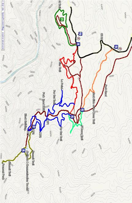
2 Figure 1. Map of Royal Gorge Trails
3 Figure 2. View of Eastern Section of Far Out Trail Figure 3. View of Royal Gorge from Le View Point
4 Figure 4. View of the Arkansas River from Le View Point
5 Royal Gorge Far Out Trail to Le Point Direction to trailhead: From East Ridge Campground: Drive west from Canon City on US 50 to County Road 3A, the entrance road to the Royal Gorge Park. Turn left onto CR 3A and drive 3.4 miles to the entrance road for the East Ridge Campground located on the left side of the road. Drive 0.7 miles to where the entrance road makes a sharp turn to the right (See Figure 1). Turn left instead onto the campground road (F 30) and follow it staying to the right until it dead ends at a circular turn around. The trailhead sign is located near the southeast side of the turnaround. About 4.2 miles one way. Length of hike: 2.66 miles RT for option miles RT for option 2. Beginning elevation: 6829 Elevation gain: 314 ft. Difficulty: Easy Description: From the trail head, the trail gradually increases in elevation as it meanders through open areas followed by small groves of scrub oak, juniper and pinion pine trees. Mountain mahogany bushes also are commonly seen along this section of the trail. Great views are afforded of the mountains to the north, the Skyline hogback mesa and Canon City (Figure 2). After about 0.68 miles from the trailhead, the Far Out Trail intersects a side trail that goes west, crosses Park Road 389B, and connects with the western side of the Far Out Trail (WP1). Option 1 is for you to follow the western side of the Far Out Trail to an overlook spur called Le Point (Figure 1). This spur provides wonderful views of the canyon walls (Figure 3) and the Arkansas River below (Figure 4). Then follow the trail back the way you came foe a round trip distance of 2.66 miles. Option(2 is to continue southeast. In about 0.21 miles the Far Out Trail intersects itself at the northern end of a large loop (WP2). The trail then makes a sharp turn to the southwest. After about 0.13 miles the trail turns back to the southeast. You will pass the unmarked Summit Trail on the left (east) that drops a few feet down the eastern side of the ridge, then continues southeast below the Far Out Trail (Figure 1). Stay on the Far Out Trail. After another 0.23 miles the trail intersects Park Road 389B at the southern end of the loop (WP3). After crossing the road, the trail makes a sharp turn to the northwest. In about 0.25 miles it again crosses Park Road 389B (WP4), then turns northeast taking you back to the northern end of the loop at WP2. Follow the trail back to WP1. There you will cross over to the western side of the trail. Follow the trail northwest until it reaches the Le View spur trail to the left (west). Take the spur trail out to rim of the canyon to Le View point (Figure 1). Return the way you came to the trail head and parking lot for a total hiking distance of 3.73 miles.
6 Figure 1. Map of Royal Gorge Trails


7 Figure 2. View of Eastern Section of Far Out Trail Figure 3. View of Royal Gorge from Le View Point

8 Figure 4. View of the Arkansas River from Le View Point
Skyline Drive Hogback Canon City
 Skyline Drive Hogback Canon City Direction to trailhead: From US 50, turn north onto 15th Street. At the traffic circle, continue north on 15th Street until it dead ends at Washington Street (about 1.5
Hiking Las Vegas.com
 Hike: Mt. Wilson via First Creek Canyon route Trailhead: First Creek marked Distance: 10 miles up and back Elevation gain: 3,400 feet Elevation of Peak: 7,070 feet Time: 7 to 9 hours (up and back) Difficulty:
Piestewa Peak/Dreamy Draw Trail Guide
 Piestewa Peak/Dreamy Draw Trail Guide Trail #1A - Perl Charles Memorial Trail Length: 4.8 miles Elevation: 2,200 ft. - 1,340 ft. Difficulty: Moderate to difficult The Perl Charles trailhead is located
Route #1) Mt. of the Holy Cross - North Ridge
 Mt. of the Holy Cross - North Ridge") Climbing 14ers can be very dangerous, please read the Mountaineering Safety Page and make sure you have a map+compass and can use them effectively, without the help of electronic devices. Route #1) Mt.
Climbing 14ers can be very dangerous, please read the Mountaineering Safety Page and make sure you have a map+compass and can use them effectively, without the help of electronic devices. Route #1) Mt.
Hiking Las Vegas.com
 Hike: Juniper Peak up and back Trailhead: Oak Creek Canyon marked Distance: 5.5 miles round trip Elevation gain: 2,200 feet Elevation peak: 6,109 feet Time: 4 to 5 hours - Up and back Difficulty: 3 Danger
GIFFORD PINCHOT NATIONAL FOREST
 GIFFORD PINCHOT NATIONAL FOREST 9341 Wright Meadow 93 Spencer Meadow Spencer Butte 4247' 30 30A 19 24 80 31C Lewis River Lower Falls 5 Quartz Creek 90 Taidnapam Falls Upper Falls 31 Spencer Peak 3861'
West Trails Trek Guide. Chief Pontiac Trail Credential Hikes
 West Trails Trek Guide Kensington Start Edition Chief Pontiac Trail Credential Hikes RDS.WTW.110609 WP# Dist. Accum. Dist. Accum. Feet Miles Meters Meters 1 0 0.0 0 0 2 410 0.1 125 125 3 164 0.1 150 275
Trail Phasing Plan. Note: Trails in the Clear Creek Canyon area (Segments will be finalized in the future to minimize wildlife impacts
 Note: Trails in the Clear Creek Canyon area (Segments 2 5 and a future JCOS connection) will be finalized in the future to minimize wildlife impacts Trail Phasing Plan P Parking 3 Easy Trail Intermediate
Drive and Stop Routes
 Drive and Stop Routes Limantour Road 1 - easy and likely productive. From Bear Valley Visitor Center drive back out and turn left onto Bear Valley Rd. Turn left at Limantour Road (the first road). Drive
MOAB peopleforbikes.org/e-bikes
 emtb ADVENTURE MAPS MOAB peopleforbikes.org/e-bikes OVERVIEW Moab, Utah is a world-class mountain bike destination known for its vast, red sandstone landscapes nestled below the rising peaks of the La
Route #2) Mt. Massive - Southwest Slopes
 Mt. Massive - Southwest Slopes") Route #2) Mt. Massive - Southwest Slopes Difficulty: Class 2 Ski: Advanced, D6 / R2 / III Exposure: Summit Elevation: Trailhead Elevation: Elevation Gain: Round-trip Length: Trailhead: County Sheriff:
Route #2) Mt. Massive - Southwest Slopes Difficulty: Class 2 Ski: Advanced, D6 / R2 / III Exposure: Summit Elevation: Trailhead Elevation: Elevation Gain: Round-trip Length: Trailhead: County Sheriff:
Searchlight NV. Est Road is about 35 trail miles south of Searchlight. OLD CORRAL
 EAST LANFAIR VALLEY TRAIL NORTH The East Lanfair Valley Trail runs north/ south from Searchlight, NV to Goffs, CA, a distance of about 48 trail miles. The northern por on is also considered to be part
OMH Trail Data / History
 Lake Sylvia Loop Ouachita National Forest (AR) This is a five-mile loop with several variations for Saturday hikes. The basic loop starts at Lake Sylvia campground and goes south to meet the Ouachita Trail
Bradshaw Trails Series
 Bradshaw Trails Series Curtis James Troop 7014 Curtis.James@erau.edu My Motto: Never get lost! Hiking Rules Bradshaw Hiking Patch Series Hiking Tools Hiking Rules Hiking Merit Badge* Take five 10-mile
White Mountain Wilderness Trails
 The area in which these hikes are located is rugged high mountain country along the Mogollon Rim. This famous eastwest escarpment separates Arizona's high plateau from the basin and range below. These
Southern Utah University Hike Brochure
 Southern Utah University Hike Brochure Taylor Creek Trail Twenty minutes from Cedar City Red Hollow An hour and a half from Cedar City Fees: Entrance fee to Kolb Canyon Length: 5 miles round trip Length:
CIEC 9 PEAKS AWARD SUPPLEMENT POSSIBLE ROUTES FOR THE 9 PEAKS AWARD TRIP
 CIEC 9 PEAKS AWARD SUPPLEMENT POSSIBLE ROUTES FOR THE 9 PEAKS AWARD TRIP As you plan your trip, be aware of 3 regulations in this wilderness: 1. Camp only in designated campsites. 2. No campfires allowed.
Trail Beginning Elevation: 7553 ft The Poison Creek Trailhead is located at the end of National Forest Road 646E (NF-646E).
.") West Mountain Trails Poison Creek Trail #134 Length: 2.9 miles (4.7 km) Difficulty Horseback: A good trail for the first time west mountain rider, some steep sections Hiking: Most Difficult USGS Maps:
West Mountain Trails Poison Creek Trail #134 Length: 2.9 miles (4.7 km) Difficulty Horseback: A good trail for the first time west mountain rider, some steep sections Hiking: Most Difficult USGS Maps:
Telluride-to-Moab Alternative Singletrack Options
 Telluride-to-Moab Alternative Singletrack Options Day 1 Day 1 Alternate 1: Galloping Goose to Deep Creek. 18.4 miles, ascent 3,530ft, descent 1,388ft. This is fun, flowey, moderate to intermediate singletrack
Rogue Gorge (Mt. Stella) Roadless Area-- T30S R3E (primarily in portions of Sections 23, 26, 33, 34 & 35)
 Roadless Area-- T30S R3E (primarily in portions of Sections 23, 26, 33, 34 & 35)") Rogue Gorge (Mt. Stella) Roadless Area-- T30S R3E (primarily in portions of Sections 23, 26, 33, 34 & 35) Rogue River-Siskiyou National Forest--High Cascades Ranger District Upper, higher elevation trail
Rogue Gorge (Mt. Stella) Roadless Area-- T30S R3E (primarily in portions of Sections 23, 26, 33, 34 & 35) Rogue River-Siskiyou National Forest--High Cascades Ranger District Upper, higher elevation trail
YOSEMITE ON HORSEBACK: THREE RIDES ALONG TIOGA ROAD Cindy Casey White Wolf Area, May Lake Loop, Ragged Peak Loop
 YOSEMITE ON HORSEBACK: THREE RIDES ALONG TIOGA ROAD Cindy Casey White Wolf Area, May Lake Loop, Ragged Peak Loop The high country along Tioga Road presents us with some of the most dramatic scenery in
(west) onto Charleston Boulevard. Drive 16 miles on Charleston and turn right into Red Rock
 onto Charleston Boulevard. Drive 16 miles on Charleston and turn right into Red Rock") Hike: North Peak and Ice Box Overlook up and back Trailhead: 2.5 miles up the Rocky Gap Road not mark Distance: 5 miles round trip Elevation gain: 2,694 feet Elevation Peak: 7,094 feet Time: 3 to 5 hours
Hike: North Peak and Ice Box Overlook up and back Trailhead: 2.5 miles up the Rocky Gap Road not mark Distance: 5 miles round trip Elevation gain: 2,694 feet Elevation Peak: 7,094 feet Time: 3 to 5 hours
C E N T R A L C A T S K I L L S
 120 C E N T R A L C A T S K I L L S Central Catskills Once out of the southern parts of the Catskills, the Long Path enters the more well traveled and civilized regions. The trail joins the Devil s Path,
Non-motorized Trail Plan & Proposal. August 8, 2014
 Town of Star Valley Ranch, Wyoming and the Star Valley Ranch Association in partnership with the USDA Forest Service, Bridger-Teton National Forest, Greys River Ranger District Non-motorized Trail Plan
Anderson Mt. Proposed Wilderness Additions to the Rogue-Umpqua Divide Wilderness-- T30S R3E (mostly) Sections 4 & 9, and T29S R3E Section 33
 Sections 4 & 9, and T29S R3E Section 33") Anderson Mt. Proposed Wilderness Additions to the Rogue-Umpqua Divide Wilderness-- T30S R3E (mostly) Sections 4 & 9, and T29S R3E Section 33 When the 35,701 acre Rogue-Umpqua Divide Wilderness was designated
Anderson Mt. Proposed Wilderness Additions to the Rogue-Umpqua Divide Wilderness-- T30S R3E (mostly) Sections 4 & 9, and T29S R3E Section 33 When the 35,701 acre Rogue-Umpqua Divide Wilderness was designated
Mazatzal Wilderness Trail Maintenance and Exploration
 Mazatzal Wilderness Trail Maintenance and Exploration March 15-19 (Wednesday - Sunday) Difficulty: Beginner Camping: Car Camping Mileage: Wednesday ~4 miles Thursday ~4-6 miles Friday ~4-6 miles Saturday
Blue Ridge Hiking Club Hike List July- September 2016
 Blue Ridge Hiking Club Hike List July- September 2016 Saturday, July 2, Elk Knob: 3.8 mile round trip with 900 ft. gain in elevation. Spectacular views at the summit. The trails are mostly moderate, but
Arches of the. Sandflats Area. By Virginia Allen
 Arches of the Sandflats Area By Virginia Allen TABLE OF CONTENTS Introduction Dedication Road Log Arches 1. Perforated View Arch 2. Fee Booth Arch 3. Windsong Arch 4. Weird Arch 5. Resting Arch 6. Bike
Guide Book Excerpts. Wham Ridge 2006
 Guide Book Excerpts Wham Ridge 2006 Approach: Molus Lake / Elk Park / Vestal Creek Roach and Roach Description Take the Durango & Silverton Narrow Gauge train from either Durango or Silverton and get off
U.S. National Forest Campground Guide
 U.S. National Forest Campground Guide Southwestern Region Arizona, New Mexico, Oklahoma and Texas National Forests and Grasslands in the Southwestern Region NF = National Forest NG = National Grassland
playwinterpark.com Off The Beaten Path Hikes Hiking Recommendations for the Adventurous Hiker
 playwinterpark.com Off The Beaten Path Hikes Hiking Recommendations for the Adventurous Hiker Hike: Devil s Thumb (difficult) Length: 3.93 miles one-way Elevation: Trailhead 9609 Destination 12,236 Trailhead
Crystal Lake Area Trails
 Lake Area Trails Welcome to the Lake area of the Big Snowy Mountains! This island mountain range in central Montana features peaks reaching to 8,600 feet and long, high ridges from which vistas of the
S H A W A N G U N K R I D G E T R A I L
 214 Shawangunk Ridge Trail The Shawangunk Ridge Trail was originally conceived as a relocation of the Long Path from Harriman State Park to Minnewaska State Park. Now part of the Long Path system, the
Trailhead Ambassadors 2018 Latourell Falls: Alternative Hikes
 Trailhead Ambassadors 2018 Latourell Falls: Alternative Hikes General Note: The Historic Highway is closed from the Bridal Veil exit to its eastern end near Wyeth i.e., the Waterfall Alley section. The
16.5 Mile Trek Guide. Chief Pontiac Trail Credential Hikes RDS.H
 16.5 Mile Trek Guide Chief Pontiac Trail Credential Hikes RDS.H.110609 WP# Dist. Feet Accum. Miles Dist. Meters Accum. Meters 1 0 0.0 0 0 2 961 0.2 293 293 3 820 0.3 250 543 4 866 0.5 264 807 4a 407 0.6
Rock Creek Park, MD - Lake Needwood
 ock Creek Park, MD - Lake Needwood Lake Needwood, is a reservoir located at the end of the north end of the ock Creek hiker-biker trail. At the other end, ock Creek empties into the Potomac iver near Thompson
Stephens State Park Trails
 TRAILS OF ALLAMUCHY MOUNTAIN & STEPHENS STATE PARKS Allamuchy Mountain and Stephens State Parks contain 28 marked trails providing access to diverse landscapes for walking, hiking, biking, bird-watching,
Marilla Reservoir to Chestnut Ridge via Marilla Trails and Bullis Hollow Trail east to west
 USGS topographic maps useful to this hike are the Bradford and Stickney 7.5 minute sectionals. These notes are designed to assist in identifying distance and location using geophysical and man-made characteristics
AOTA ArtTrek Locations
 AOTA ArtTrek Locations ArtTrek is a summer-long Grand County, CO art adventure. Highlighted by snow-covered mountain vistas and rolling meadows threaded with sparkling streams and rivers, numerous sites
Hiking Trail Descriptions
 Hiking Trail Descriptions For ye shall go out with joy. And be led forth with peace. The mountains and the hills shall break forth before you in singing. And all the trees of the fields shall clap their
Suggested Day Hikes. Mount Greylock State Reservation 3, 4 1, 2. Take a Hike! Things to remember:
 Suggested Day Hikes Mount Greylock State Reservation Take a Hike! This guide offers suggested day hike routes in two parts: 1) Year-round Hikes and 2) Seasonal Hikes (late-may to Nov.1). Use this guide
beach. Make the ford and follow the trail out to the junction with Red Creek Tr in an open grassy area.
 Description: This is a moderate to slightly strenuous 22.8 mile backpack (add 2.6 miles if you do the packless out and back to the Lion s Head) that will have you exploring nearly every thing that is The
NATIONAL ATV / UTV JAMBOREE RIDES
 NATIONAL ATV / UTV JAMBOREE RIDES Note: Rides range from Beginner to Advanced and will last from 2 to 3 hours or an entire day of riding. 1. DESERT RIDE (CLEAR LAKE BIRD REFUGE & LACE CURTAINS/LAVA TUBES)
Subject to sale, withdrawal, or error.
 The Crawford L Bar Ranch is located approximately 40 air miles west of Albuquerque, New Mexico. This ranch truly epitomizes the description of New Mexico being the Land of Enchantment. The topography and
Logan Canyon Hiking Trail Guide
 C a c h e V a l l e y V i s i t o r s B u r e a u Logan Canyon Hiking Trail Guide Monique Beeley Legend Trail Location Guide WASATCH CACHE NATIONAL FOREST WILDERNESS PAVED WATER TRAILHEAD 9 Logan River
Raytown: overview. map. Santa Fe, Oregon, and California National Historic Trails KANSAS CITY KANSAS CITY. 38 Trail alignments: Raytown.
 Raytown: overview Blue Ridge Cut-off map 18: p.42 RICE- TREMOTI HOME Raytown Tfwy KASAS 17: p.41 JUCTIO WITH ROCK ISLAD LIE RIGHT OF WAY 16: p.40 BUS STOP AT E 51ST AD BLUE RIDGE (KASAS ) Sterling Ave
Camp Geronimo Rainbow Trails
 Camp Geronimo Rainbow Trails With over 5,000 acres of surrounding national forest, the possibilities of getting out and seeing the wilderness are almost limitless. Camp Geronimo offers some of the greatest
Driving Time: 3 hours (allow extra time for stops)
") Scenic Byways loop This journey takes visitors through the eastern edge of Mt. Rainier National Park and along two of Washington s most beloved scenic byways, the Chinook Byway and the White Pass Scenic
Scenic Byways loop This journey takes visitors through the eastern edge of Mt. Rainier National Park and along two of Washington s most beloved scenic byways, the Chinook Byway and the White Pass Scenic
CAMELBACK MOUNTAIN: CHOLLA TRAIL
 CITY OF PHOENIX :: Camelback Mountain: Cholla T rail 21 CAMELBACK MOUNTAIN: CHOLLA TRAIL IN BRIEF Camelback Mountain is the tallest point in the city of Phoenix. From the 2,704-foot summit of Camelback,
Staunton River Trail to Hoover Camp and Fork Mtn. Relay Tower (Based on September 18, 2013 hike by Ron Singleton, Fredericksburg, Va.
 Staunton River Trail to Hoover Camp and Fork Mtn. Relay Tower (Based on September 18, 2013 hike by Ron Singleton, Fredericksburg, Va.) The President's Cabin (The "Brown" House) at Camp Hoover. Sign on
Table 1: Santiago Peak Communication Site. Latitude 1 Longitude 1 Elev 2 Address T/R/S 3 APN 4 USGS Quadrangle
 County of Riverside Public Safety Enterprise Communication Project Appendix A: Candidate Site Descriptions Overview The site is located in the Cleveland National Forest (CNF) at an existing communication
Tiger Mountain State Forest:
 98 60 hikes within 60 miles: SEATTLE 20 Tiger Mountain State Forest: West Tiger Mountain Three Loop i KEY AT-A-GLANCE INFORMATION Length: 5.1 miles round-trip Configuration: Loop Difficulty: Moderate difficult
BRYCE CANYON COUNTRY Boulder Mountain Scenic backways itinerary
 BRYCE CANYON COUNTRY Boulder Mountain Scenic backways itinerary Boulder Mountain Area The high plateaus of the Aquarius Plateau (Boulder Mountain), are heavily forested and covered in countless winding
Lava Mountain Trail Distance: Elevation Range: Trail Type: Difficulty: Season: Driving Distance: Driving Time: USGS Maps: Pros Cons
 Lava Mountain Trail Distance: 13.4 miles (including the side trip to North Star Lake) Elevation Range: 5900'-8330' Trail Type: singletrack Difficulty: moderate Season: late June-October Driving Distance:
Æÿ U Æ% Sauk Point @ Segment Merrimac. Æÿ DL. Devil's Lake. State Park. Gibraltar.
 MARQUETTE Æ% 23 French Creek Wildlife Area Dells Æ% 127 Æÿ H Æÿ F (/ 51 Lake Delton Æÿ Æ% 16 90 Mirror Lake State ark Western Bifurcation Æ% 23 ortage ortage Canal 94 ine Island Wildlife Area Eastern Bifurcation
Gorgeous Relay Driving Directions September 16, 2018
 2018 Gorgeous Relay Legs 1-3 Gorgeous Relay Start: Mark O. Hatfield Trailhead, Mosier Take I-84 to Exit 69, Mosier. Follow the brown signs for the Historic Columbia River Hwy State Trail. The Start Line
Cherokee Hiking Club Trail Blurb
 Cherokee National Forest Trail #164 Distance: 6.2 miles Elevation Change: 2280 feet High Point: 3692 feet (Waucheesi Mountain) Low Point: 1412 feet (Wildcat Creek) Trail Rating: Moderately Strenuous (NW
UTAH S NATIONAL PARK TOUR
 UTAH S NATIONAL PARK TOUR DAY 1 Each client needs to check in any time at the fabulous Aria Hotel located in the heart of Las Vegas. We will meet at 6pm for a one hour orientation explaining the schedule
9 December 2016 Maxwell Wolckenhauer NYS DEC State Highway 10, Suite 1 Stamford, NY Conservation.
 Conservation Education Recreation Since 1922 9 December 2016 Maxwell Wolckenhauer NYS DEC 65561 State Highway 10, Suite 1 Stamford, NY 12167 r4.ump@dec.ny.gov RE: Windham-Blackhead Range Wilderness UMP
Oregon Section F - Page 1 WGS84 Zone 10T m
 08 N. 07 N. 06 N. Oregon Section F - Page 1 WGS84 Zone 10T LavaCampLakeTR - Lava Camp Lake Trail #4060 junction. - mi 1982.6-5287 ft LavaCampLake - Lava Camp Lake, campground, outhouse, 1/2 mile NE of
GOLDEN EARS PROVINCIAL PARK
 GOLDEN EARS PROVINCIAL PARK Trail Information as of October 10 th 2015 Do not underestimate the mountainous wilderness of Golden Ears Provincial Park. The combination of rugged terrain and rapidly changing
Figure 1 Understanding Map Contours
 Figure 1 Understanding Map Contours The light brown lines overprinted on topographic maps are called contour lines. They indicate the elevation above sea level of land features and thus permit you to view
CONTENTS. 31 THE TRAILS See next page for a complete listing of all trails and a locator map. Trail descriptions begin on page 31.
 CONTENTS Page Topic 6 Trail List 7 Trail Locator Map 8 Trails Listed by Dificulty 9 Trail Ratings Deined 11 INTRODUCTION 11 Using this Book 12 The Right Trail for You 13 About Moab 15 Utah OHV Laws and
Bennett Ridge Trail Acorn Hollow Trail. Loop E Sites Tents Only. Big Oak Trail Amphitheater
 Group Fire Ring Group Camping Area Bennett Ridge Trail Acorn Hollow Trail 89 91 Playfield 86 Big Oak Trail 90 88 87 85 84 81 82 Playfield Parking Only Sites 73-91 Tents Only 83 80 79 78 77 Big Oak Trail
Trail Notes Palouse Region Hikes
 Trail Notes Palouse Region Hikes Campus Recreation 875 Perimeter Drive MS 1230 Moscow, Idaho 83844-1230 Ph: 208.885.6810 Rentals: 208.885.6170 Fax: 208.885.6879 uidaho.edu/outdoorprogram 0 PALOUSE REGION
1. Waterfall Gully Mt Lofty. 5 Of the Best Hikes in Adelaide
 Adelaide is a beautiful city, and one of the most incredible things about Adelaide is the quality of bushwalking available on the suburban fringe. It is surrounded by the Mt Lofty Ranges, and much of the
Coast to Crest Trail Corridor Hike
 Coast to Crest Trail Corridor Hike Jim Cunningham, Poway City Council member and Board Chair of the San Dieguito River Park in 2013 has embarked on a project to hike the entire 70-mile San Dieguito River
The Superior and Des Moines lobes largely shaped Polk and Burnett counties.
 olk & Burnett Counties Trail miles: 57.1 Connecting route miles: 7.3 The Superior and Des Moines lobes largely shaped olk and Burnett counties. First, the Superior Lobe came from the northeast. Later,
Asheville & WNC Hikes
 Asheville & WNC Hikes Amazingly, we have 3,000+ miles of free public hiking trails near Asheville, including 1,600 miles in the Pisgah and Nantahala National Forests, 850 miles in Great Smokey Mountains
SCVAS & MROSD Summer Camp
 SCVAS & MROSD Summer Camp Driving Directions to: Picchetti Ranch Preserve 13100 Montebello Rd, Cupertino (Map provided below) Monday, July 20th ( Nature Explorations ) ONLY If coming from 280: 1. Take
NATIONAL ATV / UTV JAMBOREE RIDES
 NATIONAL ATV / UTV JAMBOREE RIDES Note: Rides range from Beginner to Advanced and will last from 2 to 3 hours or an entire day of riding. 1. DESERT RIDE (CLEAR LAKE BIRD REFUGE & LACE CURTAINS/LAVA TUBES)
The Croatan MST Segment 16B
 1 Mountains-to-Sea Trail Last Updated 1/1/2017 A sandy road through longleaf pine savanna in the Croatan National Forest Photo by PJ Wetzel, www.pjwetzel.com The Croatan MST Segment 16B STELLA TO THE NEUSIOK
306 Ice Age Trail Guidebook : 200,000 compilation scale. February 3, Marsh. Glenbeulah. Greenbush. Sheboygan. Parnell. Segment.
 G MANITOWOC Existing Ice Age Trail, subject to change as it evolves toward completion FOND DU LAC Other Trail Unofficial Connecting Route (unmarked) County Boundary ublic or IATA Land Miles 0 1 2 3 4 Marsh
NATIONAL ATV JAMBOREE RIDES
 NATIONAL ATV JAMBOREE RIDES Note: Rides range from Beginner to Advanced and will last from 2 to 3 hours to an entire day of riding. 1. WHITE SAGE: 50 or Less, This trail is recommended for ADVANCED RIDERS.
Internet TripTik. From : Zion National Park, Ut Stop At Stop At Stop At Stop At Stop At. : Bryce Canyon National Park, Ut : Arches National Park, Ut
 MAP: Overview Internet TripTik From : Zion National Stop At Stop At Stop At Stop At Stop At To : Bryce Canyon National Park, Ut : Arches National : Canyonlands National : Monument Valley, Utah : Kayenta,
Route Combo) Mt. Bierstadt - Bierstadt, Sawtooth, Evans
 Mt. Bierstadt - Bierstadt, Sawtooth, Evans") Climbing 14ers can be very dangerous, please read the Mountaineering Safety Page and make sure you have a map+compass and can use them effectively, without the help of electronic devices. Route Combo)
Climbing 14ers can be very dangerous, please read the Mountaineering Safety Page and make sure you have a map+compass and can use them effectively, without the help of electronic devices. Route Combo)
Cascading Rivers Scenic Bikeway
 Milo McIver State Park Main Clackamas Start Estacada Faraday Rd 5 Promontory Park Estacada Start ESTACADA CHAMBER OF COMMERCE (parking in back) SE 4 th Ave Stay west to take Faraday Rd. (closed to motorized
Montrose Segment (Atlas Map 67f)
") short switchbacks, then curls southward to reach the Trail access at a gate in the northwestern corner of the park s parking area near CTH-B. The moraine and the Ice ge Trail are fenced off from a heavily
short switchbacks, then curls southward to reach the Trail access at a gate in the northwestern corner of the park s parking area near CTH-B. The moraine and the Ice ge Trail are fenced off from a heavily
East West route and Leatham Molesworth route (route guide) Molesworth Recreation Reserve
 Molesworth Recreation Reserve") East West route and Leatham Molesworth route (route guide) Molesworth Recreation Reserve 0BIntroduction The East West route links the Clarence (Kahutara River in Ka Whata Tu o Rakihouia) Conservation Park
East West route and Leatham Molesworth route (route guide) Molesworth Recreation Reserve 0BIntroduction The East West route links the Clarence (Kahutara River in Ka Whata Tu o Rakihouia) Conservation Park
Blue Ridge Hiking Club - First Quarter 2018 Hikes
 Blue Ridge Hiking Club - First Quarter 2018 Hikes Monday, Jan 1: Trout Lake to Manor House & Figure 8 Trail: Meet at Trout Lake parking lot, at 9:30. (1st exit left off Parkway just south of Cone Manor
Trapper Trails Council Camping Guide
 East Canyon State Bear Lake State Antelope Island State 12 Miles south Morgan, UT Bear Lake on Idaho/Utah border Exit 332 off I-15, then west to Entrance Idaho State Weber Memorial south fork ogden river
Note: Coordinates are provided as Universal Transverse Mercator UTM Zone U21, North American Datum 1983 (NAD 83).
.") Northern Traverse Route Description The Northern Traverse (formerly the North Rim Traverse) is an unmarked and rugged backcountry hiking route. It is known be a demanding hike, because of its terrain and
Northern Traverse Route Description The Northern Traverse (formerly the North Rim Traverse) is an unmarked and rugged backcountry hiking route. It is known be a demanding hike, because of its terrain and
Climbing Oak and Brushy Top Mountains
 Climbing Oak and Brushy Top Mountains Story and photographs by Vann Helms www.blueridgeimpressions.org Brushy Top Mountain- February 2, 2014 Brushy top summit After a January of record breaking cold weather,
155 acres on Tyaughton Lake 900 feet of Pristine Waterfront Private & Secluded Property
 155 acres on Tyaughton Lake 900 feet of Pristine Waterfront Private & Secluded Property 946 Tyaughton Lake Road Gold Bridge BC V0K1P0 900 ft of waterfront with 155 acres of south facing easy access. This
Springettsbury Township. Road Improvement Projects
 Springettsbury Township Road Improvement Projects 2009 2016 2016 Township Road Improvement Projects Springettsbury Township is divided into the following 4 Sectors: Northwest Sector Sherman Street Route
Location: Height: Access: Distance: Elevation: Season: Difficulty: Lat/Long: Directions:
 Upper Eagle Falls Upper Eagle Falls (~20 ft.) is a short hike up from the roadside at the Eagle Falls picnic area. It is very difficult to get a parking spot here during the day, so it is recommended to
CATARACT CREEK ESTATES
 CATARACT CREEK ESTATES EXCLUSIVE LISTING WILLIAMS, ARIZONA LOCATION NWC of Airport Road and Lake Ellen Way, Williams, Arizona SIZE ±38.95 acres LOT DESCRIPTION 55 P&E Single Family Lots (7,000 sq. ft.)
UMASS CROSS-COUNTRY Trails
 UMASS CROSS-COUNTRY Trails 1) EGG (43 min) (A) From Cage proceed to North Pleasant street (by campus pond). Make left and head toward LGRT and pass School of Education. Pass Puffton Apt complex (on left)
A Publication of Friends of Sleeping Bear Dunes
 A Publication of Friends of Sleeping Bear Dunes 2014, Friends of Sleeping Bear Dunes, P.O. Box 545, Empire, MI 49630 www.friendsofsleepingbear.org info@friendsofsleepingbear.org Learn more about the Friends
Table 1: Rancho Carrillo Communication Site. Latitude 1 Longitude 1 Elev 2 Address T/R/S 3 APN 4 USGS Quadrangle
 County of Riverside Public Safety Enterprise Communication Project Appendix A: Candidate Site Descriptions Overview The site is located in the Cleveland National Forest (CNF) atop a low ridge adjacent
Table 1: Paradise Communication Site. Latitude 1 Longitude 1 Elev 2 Address T/R/S 3 APN 4 USGS Quadrangle
 County of Riverside Public Safety Enterprise Communication Project Appendix A: Candidate Site Descriptions Overview The site is located atop a west-facing ridge overlooking the City of Norco, approximately
Covenant Health presents
 Covenant Health presents www.covenanthealth.com 1. 2. 3. 4. 5. 6. 7. 8. 9. 10. 11. Trail Guidelines Wear proper hiking shoes. Please be on time. Make sure that you understand & have signed the waiver.
SAMPLE HIKING TRIPS Made with love by your CUHC Officers
 SAMPLE HIKING TRIPS Made with love by your CUHC Officers DISCLAIMER: Be sure to check trail conditions and weather before you hit the trail! IMPORTANT: Permits and wilderness regulations are frequently
Trailhead Ambassadors 2018 Starvation Creek: Alternative Hikes
 Trailhead Ambassadors 2018 Starvation Creek: Alternative Hikes Starvation Creek Summary Near the Trailhead: o Starvation Creek Falls. Just a short walk to the east. o Loop trail to Cabin Creek Falls, Hole-in-the-Wall
Trails Technical Committee
 Trails Technical Committee Winter 2017 Draft Report Alignment Proposals for the Inyo National Forest and the Town of Mammoth Lakes Map ID #S18 February 08, 2017 Map ID #S18 Key Agreements As of February
ANGELES NATIONAL FOREST
 Most campgrounds on the Angeles National Forest are first come, first served. However, some are managed by concessionaires who do take reservations. The National Forest Adventure Pass or Interagency passes
Photographing Upper Peninsula Waterfalls
 Photographing Upper Peninsula Waterfalls Tod Poirier Freelance Photographer Photography is one of my passions. The following spread showcases several Upper Peninsula waterfalls. At times a single drop
San Luis Obispo. Bishop Peak Felsman Loop Eagle Rock Maino Open Space Poly Canyon Poly P Other Areas
 San Luis Obispo Bishop Peak Felsman Loop Eagle Rock Maino Open Space Poly Canyon Poly P Other Areas 1 JCT. ELEV. 72 400 00 0 FELSMAN LOOP GATE LOOP RIDGE 600 FENCE JCT. ELEV. 860 1000 1200 BISHOP PEAK
IOWA ORNITHOLOGISTS' UNION - Birding Sites in Linn County
 IOWA ORNITHOLOGISTS' UNION - Birding Sites in Linn County Printed on 6/15/2018 Bever Park (ebird Hotspot) GPS Coordinates: 41.9851219,-91.6269125 Restrooms Parking Trails ADA Accessible Trails Boyson Trail
Guide Book Excerpts From Colorado Hut to Hut, Volume 1 Northern & Central Regions, by Brian Litz
 Guide Book Excerpts From Colorado Hut to Hut, Volume 1 Northern & Central Regions, by Brian Litz Sangree M. Froelicher Hut HUT 11,630 ELEVATION DATE BUILT 1998 SEASONS Thanksgiving through April 30 (winter);