Drive and Stop Routes
|
|
|
- Felicity Russell
- 5 years ago
- Views:
Transcription
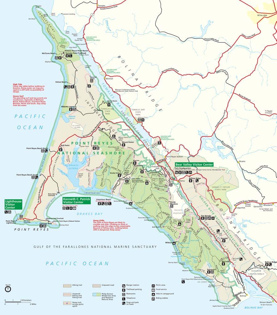
1 Drive and Stop Routes Limantour Road 1 - easy and likely productive. From Bear Valley Visitor Center drive back out and turn left onto Bear Valley Rd. Turn left at Limantour Road (the first road). Drive along Limantour Road and stop any at sites that catch your fancy. Concentrate your efforts in the area between the beginning of the road and the Bay View Trail head parking lot, which is near the top of the ridge just before you start to descend toward the ocean. In the more open sunny areas be aware of poison oak, especially at and after Sky Trailhead! Zones to mark on your collections LIM-1 Meadow and Oak woodland near the beginning of the road. LIM-2 Young second growth Douglas Fir Forest before Sky Trail head parking lot LIM-3 From Sky trail head to Bay View Trail head LIM-4 from Bay View Trail head to the junction of Muddy Hollow/ Hostel Road LIM-5 from the junction of Muddy Hollow/ Hostel Road to Limantour Beach parking lot.
2 Limantour Road 2 - easy and likely productive in the young pine areas. From Bear Valley Visitor Center drive back out and turn left onto Bear Valley Rd. Turn left at Limantour Road (the first road). Drive along Limantour Road until you reach the Bay View Trail head. Start there and continue toward the beach, stop at any sites that catch your fancy. In the more open sunny areas be aware of poison oak, especially at and after Sky Trailhead! Zones to mark on your collections LIM-4 from Bay View Trail Head to Junction of Muddy Hollow/ Hostel Road LIM-5 from Junction of Muddy Hollow/ Hostel Road to Limantour Beach Parking lot.
 and follow the road all the way to the beach. Park at the main lot. Walk to the beach and collect in and around grass and shrubs just behind the dunes.")
3 Limantour Beach - Dune and grassland area. These areas can be rich in several genera of saprobes. From Bear Valley Visitor Center drive back out and turn left onto Bear Valley Rd. Turn left at Limantour Road (the first road) and follow the road all the way to the beach. Park at the main lot. Walk to the beach and collect in and around grass and shrubs just behind the dunes. Then get back in your car head back up Limantour Rd. and take the first right toward the other parking lot on the east end of the beach. Again walk toward the beach and collect in the grasslands and shrubs just behind the dunes. You can also try in the shrub/grasslands before the parking lot. There is a recent prescribed burn that could be interesting. Zones to mark on your collections LIMB-1 dunes west of main parking lot (there is a trail in these and its easier to walk) LIMB-2 dunes east of main parking lot LIM-5B Recently Burned area on the way to the second parking lot LIMB-3 dunes near second parking lot
4 Mt Vision Road- mature Bishop pine forest and coastal scrub. This route gives beautiful views and excellent habitat. From Bear Valley Visitor Center drive back out and turn left onto Bear Valley Rd. Drive north until the road dead ends into the Sir Francis Drake and turn left. Continue past Inverness Park and Inverness. When the road forks about 1.5 miles past Inverness stay on the main road to the left. Less than a mile after this fork turn left onto the narrow paved road marked Mt. Vision. Stop and collect along this road anywhere that it looks interesting and is safe to pull off. The lower parts of the road are mostly scrub community with isolated pockets of pine. Further up this becomes a continuous mature pine forest, and near the end it becomes a young (post-fire) pine forest and scrub. All of these pine areas can be incredibly productive. Be careful of poison oak throughout, but especially on the lower parts of the road or anywhere with lots of other shrubs. Zones to mark on your collections MtVB bottom part of Mt. Vision Road before the pine forest become fairly continuous MtVM middle area of Mt Vision Road where the mature Pine forest becomes continuous. MtVT top of Mt. Vision Road where the pine forest is young.
5 Easy hikes Bear Valley Trail 1 - A flat wide, easy road-like trail. Mostly through lower elevation mixed woods and grassy meadows. From the Bear Valley visitor s center walk south along the wide dirt road marked as Bear Valley trail, collected in areas along trail walk as much or as little and then return by the same route. Zones to mark on your collection labels Bear-1 from the visitor's center to the start of the forest Bear-2 is from the start of the forest until the junction with the Meadow Trail (0.8 miles) Bear-3 is between the with the Meadow Trail (0.8 miles) and the Old Pine Trail (1.6 miles) Bear-4 from Baldy Trail to Old Pine Trail Bear-5 from Arched Rock to Baldy trail junction

6 Kule Loklo Trail - flat wide trail in lowland Oak-Bay forest. the Kule Loklo Trail starts at the north end of the northern most Bear Valley parking lot. It runs for about 0.4 miles and ends at the Miwok Village. The horse trail starts there and goes up toward Mt Wittenberg. Walk as far as you like and return by the same route Mark your Collections KULE for the Kule Loklo trail HORSE for the Horse trail

7 Estero Trail area Drive with short walk; mature Monterey pine forest and coastal scrub From Bear Valley Visitor Center drive back out and turn left onto Bear Valley Rd. Drive north until the road dead ends into the Sir Francis Drake and turn left. Continue past Inverness Park and Inverness. When the road forks about 1.5 miles past Inverness stay on the main road to the left. Drive past the Mt. Vision road, and less than one mile later turn left at the sign marking the Estero Trailhead. Park in the lot and start on the trail collecting in the grasslands/scrub community and in the pine forest that is about 1/2 mile or so down the trail. Be careful of poison oak especially in the first section of pine forest (there is less further in); this forest can be excellent collecting. Past the forest the trail crosses a bridge and becomes rather muddy, but includes some farm and scrub areas (this area is not high priority, but if you go there, go ahead and collect. Zones to mark on your collections EsteroM Estero trail meadow/scrub area between trailhead and forest EsteroF Estero trail planted forest

8 Tomales Pt. The trail is broad, fairly flat and easy for the first mile. Dune, scrub, grassland areas; lots of Elk! Usually rich in Agaricus, puffballs, and various other saprobes. The scenery can be stunning and there is little or no poison oak, but the wind can be brutal. : From Bear Valley Visitor Center drive back out and turn left onto Bear Valley Rd. Drive north until the road dead ends into the Sir Francis Drake and turn left. Continue past Inverness Park and Inverness. When the road forks about 1.5 miles past Inverness take the right on Pierce Point Rd and head north to Tomales Pt. Drive to the end of the road, park at Pierce Ranch (just before McClure Beach) and take the Tomales Pt. Trail. It is easy to go off trail in this area and search the grasslands. Zones to mark TomPt1 first part of Tomales bay trail up to Windy Gap (the first big drop in elevation). TomPt 2 trail after Windy Gap. KEHOE if you stop and collect along Kehoe beach trail ABBOT if you stop and collect along the Abbots lagoon trail

9 South Olema Trail - mixed Oak/Bay woodlands with Douglas-fir : From Bear Valley Visitor Center drive back out and turn right onto Bear Valley Rd then turn right again on HWY 1. Drive about 6.2 miles, and park at the small pull-off for the Olema and Randall trails. Take the Olema Tail and at the trail junction (0.5 miles) continue on the Olema Trail north toward the Bolema Trail (the more wooded direction), or south into the meadows. Return by the same route. Mark your collections OLEMA2 for the Olema Trail up to the junction with the Bolema trail BOLEMA Bolema Trail OLEMA1 for Olema Trail after junction
10 Moderate hikes (longer or up and down hills) Sky Trail from Limantour a short to long hike along an uphill old road. Vegetation is mixed Douglas-fir Pine and Douglas-fir forest. From Bear Valley Visitor Center drive back out and turn left onto Bear Valley Rd. Turn left at Limantour Road, drive about 2 miles and pull into the Sky trailhead on left. Walk up the Sky trail and to Sky Camp (1.3 miles) or as far as you feel like and return by the same route Mark your collections SKY-1
11 Horse Trail to Mt. Wittenberg a steady uphill along a wide trail though mixed oak Douglas-fir forest From Bear Valley Visitor Center drive back out and turn left onto Bear Valley Rd. Turn left at Limantour, drive about a mile. When the road takes a sharp right, there is a pull-off on the left near a gate. Stop there, and walk through the gate. After about 100 yards the horse trail turns off to the right and continues uphill 1.7 miles to next trail junction. Take the trail as far as you want collecting along the way and then return the same way. Mark your collections HORSE
12 Upper Bay View & Laguna Trail young post-fire pine forest and northern coastal scrub : From Bear Valley Visitor Center drive back out and turn left onto Bear Valley Rd. Turn left at Limantour Road (the first road). Drive along Limantour Road as you crest the hill and start going down to the ocean you ll see huge numbers of young pine. The first turn-off to the right is the Bay View Trailhead; pull in and park. You can walk down the Bay View trail or cross Limantour Rd and walk along the Bay View Trail to the Laguna Trail (0.5) miles. Both trails eventually drop into coastal scrub, but have young pine and some Douglas-fir in the first half mile or so. Walk as far as you choose, but remember that you have to walk back up. If you have a two car group you could drop one car at Muddy Hollow or the Laguna trailhead and do a one way downhill walk (about 2 miles). Watch for poison oak. Zones to mark on your collections BAY-1- Upper Bay View Trail in the pine forest BAY-2 Bay View Trail across the road from parking lot BAY-3 Lower Bayview Trail from end of pine forest to Muddy Hollow LAGUNA-1 first half of Laguna trail from Bay View to Hostel Road
. Drive along Limantour Road until you reach the Muddle Hollow turn off and then turn right into it.")
13 Lower Bay View Trail/Muddy Hollow Cypress grove, Alder and willow along creek, coast scrub. From Bear Valley Visitor Center drive back out and turn left onto Bear Valley Rd. Turn left at Limantour Road (the first road). Drive along Limantour Road until you reach the Muddle Hollow turn off and then turn right into it. Park when the road ends, abd walk across Muddle Hollow Creek (this can be tricky if the water is high), and at the trail junction head up the Bay View Trail. The Cypress grove and the creek side vegetation has some unique fungi. Further up the trail you will encounter mostly northern coastal scrub and isolated pine. Watch for poison oak in this area. Walk up as far as you wish. Zones to mark on your collections MUD muddy hollow area with creek vegetation and Cypress BAY-3 lower Bay View and Drakes View trail until you reach fairly continuous pine forest BAY-1- Upper Bay View Trail in the pine forest DRAKE Upper Drake View Trail in the pine forest
. Drive along Limantour Road until you reach the Muddle Hollow/Hostel turn off.")
14 Lower Laguna trail Coastal scrub with pockets of young Douglas-fir and Pine; deer and Elk likely. From Bear Valley Visitor Center drive back out and turn left onto Bear Valley Rd. Turn left at Limantour Road (the first road). Drive along Limantour Road until you reach the Muddle Hollow/Hostel turn off. Turn Left toward the hostel, drive past the hostel, and then park at the Laguna trailhead. Walk down the Laguna Trail. It s 0.8 miles to the first trail junction. At that point you can either go up the fire trail, or continue toward the beach (1.0 miles). Return by the same route. Zones to mark on your collections LAGUNA-2 Laguna Trail up to junction with the Fire Lane Trail LAGUNA-3 Laguna trail from junction to beach FIRE Lower Fire Trail

15 long or strenuous hikes Bear Valley Trail 2 a moderately long (6.2 miles) walk along a flat wide, easy roadlike trail. Mostly through lower elevation mixed woods and grassy meadows. From the Bear Valley visitor s center head south along the wide dirt road marked as Bear Valley trail. Without stopping to collect walk directly to the Baldy Trail Junction (3.1 miles from visitors center). Turn around and collect on your way back. If you really feel like walking continue on to Arch Rock (1.3 miles more). Concentrate your collecting in BVT (5, 4, and 3) Zones to mark on your collection labels Bear-5 from Arched Rock to Baldy trail junction Bear-4 from Baldy Trail to Old Pine Trail Bear-3 is between the Meadow Trail (0.8 miles) and the Old Pine Trail (1.6 miles) Bear-2 is from the start of the forest until the junction with the Meadow Trail (0.8 miles)

16 Five Brooks Area A long uphill trail through Douglas fir forest; some pine occurs near the ridge top. Great habitat! From Bear Valley Visitor Center drive back out and turn right onto Bear Valley Rd then turn right again on HWY 1. Drive about 3.7 miles, just pass Stewart s Horse Ranch and turn into the Five Brooks Trailhead. From the parking lot walk the trail and when you reach the end of the pond turn left onto the Olema Trail. A few hundred yards later, bout half way around the pond, the trail turns right away from the lake (if you go straight you end up at the stables). Continue on the Olema Trail for 1.3 miles to the junction of the Bolema trail. Take the Bolema Trail to the Ridge Trail (1.1 miles). Once at the ridge trail either return via the same route or turn right on to the Ridge trail, take it 0.8 miles to the Stewart Trail, and then take the Stewart Trail back to the parking lot (2.7 miles). Alternatively you can reverse this route going up the Stewart, which is basically a road. This is a more gradual trail with less mud. Zones to mark OLEMA-1 - Olema trail BOLEMA - Bolema trail Ridge-1 - Ridge Trail STEW - Steward Trail

17 Teixiera trail to the Ridge trail Steep climb through Douglas-fir forest From Bear Valley Visitor Center drive back out and turn right onto Bear Valley Rd then turn right again on HWY 1. Drive 8.5 miles and pull off at the side of Hwy 1 at the trailheads for the McCurdy and Olema Valley trails. Take the Olema Valley Trail for 0.5 miles. When you reach the the Teixiera Trail take it and head up to the ridge. If you reach the next trail junction (1.2 miles up hill) go either way on the Pablo Pt. Trail and then return by the same route. Mark you collections OLEM-2 Olema Valley TIEX Teixiera trail PABLO Pablo Pt. Trail Ridge-2 Ridge trail

18 Ridge Trail from Palomarin steep climb through open scrub to ridge with Douglas-fir. : From Bear Valley Visitor Center drive back out and turn right onto Bear Valley Rd then turn right again on HWY 1. Drive 9.7 miles, past Dog Town, past two 3- way intersections signs, and one unmarked road. Just before you reach Bolinas Lagoon, there is an 4-way intersection sign with no road name, turn right there and at the next T-intersection turn left. Drive 1.7 miles and just as you are entering the outskirts of Bolinas turn left onto Mesa Road (there is a sign for the Pt. Reyes Bird Observatory). Continue on Mesa Rd. about 2 miles to the Pt. Reyes Bird Observatory. Park and take the Ridge Trail on the right side of the road that goes up the hill. 0.6 miles later this intersects the Pablo Pt trail; turn left and stay on the Ridge Trail continue 1.7 miles to the Lake Ranch Trail intersection, or until you get tired then return. Return by the same route. Be careful of the poison oak on the first part of this walk. Mark your collections Ridge-2- Ridge trail
19 Mt Wittenberg trail a moderate (3.6 mile) to long (6.4) hike depending on your return route. It s a steep, strenuous trail, but it s a beautiful hike through old and young Douglas Fir Forest. You will also encounter some old Bishop pine along the Sky and Old pine trails. From the Bear Valley Visitor s Center walk south along the wide dirt road marked as Bear Valley Trail. Near the edge of the forest the Mt. Wittenberg trail cuts off to the right. Take it and start collecting. Continue as far as you have energy or until you reach the trail junction near the summit (1.8 miles). Return along the same route for a total hike of 3.6 miles). If you are up for a longer hike return via the Old Pine Trail (6.4 total) or the Meadow Trail (4.4 miles). To do this take the Sky trail south toward ocean. At the junction of Meadow Trail you can take it and return to the Bear Valley Trail (1.6 miles), or the continue on the Sky Trail past the Woodward Trail (0.8 miles), and at the Old Pine Trail junction (0.3) take a left and follow the Old Pine Trail to the Bear Valley trail (1.9 miles), and return by the Bear Valley Trail to the Visitor center (1.6 miles). Zones to mark on your collections MtWit-1 Mt Wittenberg trail from Bear Valley to the beginning of the open grassy summit area MtWit -2 Mt Wittenberg trail near the summit and the grassy meadows around the trail junctions SKY-2 from the meadow to the Old Pine Trail Meadow along the Meadow Trail Old-Pine along the Old Pine Trail
20 Meadow Trail - a moderate (4.8 mile) hike, but it s steep and strenuous. It mostly goes through old and young Douglas Fir Forest. From the Bear Valley Visitor s Center walk south along the wide dirt road marked as Bear Valley Trail. Continue past the Wittenburg trail and at the junction of the Meadow Trail (0.8 miles) take it and start collecting. Continue up (literally) the Meadow Trail and at the next trail junction either turn around and return the way you came, or turn left and head toward Mt. Wittenburg. At the junction of the Mt. Wittenburg Trail turn right and head back to the Bear Valley Trail and back to the visitor center. Zones to mark on your collections Meadow along Meadow Trail MtWit-2 near the summit and the grassy meadows around the trail junctions MtWit-1 from Bear Valley to the beginning of the open grassy summit area
21
beach. Make the ford and follow the trail out to the junction with Red Creek Tr in an open grassy area.
 Description: This is a moderate to slightly strenuous 22.8 mile backpack (add 2.6 miles if you do the packless out and back to the Lion s Head) that will have you exploring nearly every thing that is The
Lava Mountain Trail Distance: Elevation Range: Trail Type: Difficulty: Season: Driving Distance: Driving Time: USGS Maps: Pros Cons
 Lava Mountain Trail Distance: 13.4 miles (including the side trip to North Star Lake) Elevation Range: 5900'-8330' Trail Type: singletrack Difficulty: moderate Season: late June-October Driving Distance:
San Luis Obispo. Bishop Peak Felsman Loop Eagle Rock Maino Open Space Poly Canyon Poly P Other Areas
 San Luis Obispo Bishop Peak Felsman Loop Eagle Rock Maino Open Space Poly Canyon Poly P Other Areas 1 JCT. ELEV. 72 400 00 0 FELSMAN LOOP GATE LOOP RIDGE 600 FENCE JCT. ELEV. 860 1000 1200 BISHOP PEAK
Hiking Trail Descriptions
 Hiking Trail Descriptions For ye shall go out with joy. And be led forth with peace. The mountains and the hills shall break forth before you in singing. And all the trees of the fields shall clap their
Royal Gorge Far Out Trail to Le Point
 Royal Gorge Far Out Trail to Le Point Direction to trailhead: From East Ridge Campground: Drive west from Canon City on US 50 to County Road 3A, the entrance road to the Royal Gorge Park. Turn left onto
C E N T R A L C A T S K I L L S
 120 C E N T R A L C A T S K I L L S Central Catskills Once out of the southern parts of the Catskills, the Long Path enters the more well traveled and civilized regions. The trail joins the Devil s Path,
Hiking Las Vegas.com
 Hike: Mt. Wilson via First Creek Canyon route Trailhead: First Creek marked Distance: 10 miles up and back Elevation gain: 3,400 feet Elevation of Peak: 7,070 feet Time: 7 to 9 hours (up and back) Difficulty:
Trail Beginning Elevation: 7553 ft The Poison Creek Trailhead is located at the end of National Forest Road 646E (NF-646E).
.") West Mountain Trails Poison Creek Trail #134 Length: 2.9 miles (4.7 km) Difficulty Horseback: A good trail for the first time west mountain rider, some steep sections Hiking: Most Difficult USGS Maps:
West Mountain Trails Poison Creek Trail #134 Length: 2.9 miles (4.7 km) Difficulty Horseback: A good trail for the first time west mountain rider, some steep sections Hiking: Most Difficult USGS Maps:
Rogue Gorge (Mt. Stella) Roadless Area-- T30S R3E (primarily in portions of Sections 23, 26, 33, 34 & 35)
 Roadless Area-- T30S R3E (primarily in portions of Sections 23, 26, 33, 34 & 35)") Rogue Gorge (Mt. Stella) Roadless Area-- T30S R3E (primarily in portions of Sections 23, 26, 33, 34 & 35) Rogue River-Siskiyou National Forest--High Cascades Ranger District Upper, higher elevation trail
Rogue Gorge (Mt. Stella) Roadless Area-- T30S R3E (primarily in portions of Sections 23, 26, 33, 34 & 35) Rogue River-Siskiyou National Forest--High Cascades Ranger District Upper, higher elevation trail
Route #2) Mt. Massive - Southwest Slopes
 Mt. Massive - Southwest Slopes") Route #2) Mt. Massive - Southwest Slopes Difficulty: Class 2 Ski: Advanced, D6 / R2 / III Exposure: Summit Elevation: Trailhead Elevation: Elevation Gain: Round-trip Length: Trailhead: County Sheriff:
Route #2) Mt. Massive - Southwest Slopes Difficulty: Class 2 Ski: Advanced, D6 / R2 / III Exposure: Summit Elevation: Trailhead Elevation: Elevation Gain: Round-trip Length: Trailhead: County Sheriff:
Telluride-to-Moab Alternative Singletrack Options
 Telluride-to-Moab Alternative Singletrack Options Day 1 Day 1 Alternate 1: Galloping Goose to Deep Creek. 18.4 miles, ascent 3,530ft, descent 1,388ft. This is fun, flowey, moderate to intermediate singletrack
Pontfadog. Walk A. Walk A
 Walk A A Bird s eye view of the village 2km. (1 1 /2 miles); height gain 45m. (150ft) about 45 minutes. Six minutes walk along the main road towards Glyn Ceiriog reach a signpost to Llwynmawr. Take the
Tiger Mountain State Forest:
 98 60 hikes within 60 miles: SEATTLE 20 Tiger Mountain State Forest: West Tiger Mountain Three Loop i KEY AT-A-GLANCE INFORMATION Length: 5.1 miles round-trip Configuration: Loop Difficulty: Moderate difficult
CIEC 9 PEAKS AWARD SUPPLEMENT POSSIBLE ROUTES FOR THE 9 PEAKS AWARD TRIP
 CIEC 9 PEAKS AWARD SUPPLEMENT POSSIBLE ROUTES FOR THE 9 PEAKS AWARD TRIP As you plan your trip, be aware of 3 regulations in this wilderness: 1. Camp only in designated campsites. 2. No campfires allowed.
The Trails. Hwy. 40 Kananaskis Valley. Hwy. 1 Canmore, Bow Valley. Hwy. 40 Peter Lougheed Prov. Park. Hwy. 742 The Smith-Dorrien. Hwy.
 The Trails Hwy. 1 Canmore, Bow Valley 1 Grassi 8 2 Ha Ling Peak 13 3 Teahouse Ridge 17 4 Grotto Canyon 21 5 Raven s End 24 6 Bow Valley Provincial Park Loop 28 7 Heart Mountain Circuit 32 8 Wind Ridge
Slad over to Pitchcombe and back
 The walk climbs up from Slad over Wickridge Hill, descends to near Pitchcombe, then climbs back over Wickridge hill and round the back of Slad. Page 1 Start Point: SO 8718 0732 The Woolpack, Slad Length:
COURSE DESCRIPTION AND DIRECTIONS
 COURSE DESCRIPTION AND DIRECTIONS START TO BOUNTIFUL B (MILE 0 to MILE 17.05) From the start at East Mountain Wilderness Park, go past the green metal gate of East Mountain Wilderness Park and follow the
Blue Ridge Hiking Club Hike List July- September 2016
 Blue Ridge Hiking Club Hike List July- September 2016 Saturday, July 2, Elk Knob: 3.8 mile round trip with 900 ft. gain in elevation. Spectacular views at the summit. The trails are mostly moderate, but
A Publication of Friends of Sleeping Bear Dunes
 A Publication of Friends of Sleeping Bear Dunes 2014, Friends of Sleeping Bear Dunes, P.O. Box 545, Empire, MI 49630 www.friendsofsleepingbear.org info@friendsofsleepingbear.org Learn more about the Friends
Stephens State Park Trails
 TRAILS OF ALLAMUCHY MOUNTAIN & STEPHENS STATE PARKS Allamuchy Mountain and Stephens State Parks contain 28 marked trails providing access to diverse landscapes for walking, hiking, biking, bird-watching,
BRR Leg 1 (3.9 miles, Easy)
") BRR Leg 1 (3.9 miles, Easy) Min 3901 Max 4919 Ascent +21 Descent -1031 0.0 Start (Grayson Highlands State Park Visitor Center) 3.9 Grayson Highlands State Park Office & Gate, on R (EZ 1) Leg Notes: Minimal
BRR Leg 1 (3.9 miles, Easy) Min 3901 Max 4919 Ascent +21 Descent -1031 0.0 Start (Grayson Highlands State Park Visitor Center) 3.9 Grayson Highlands State Park Office & Gate, on R (EZ 1) Leg Notes: Minimal
Cherokee Hiking Club Trail Blurb
 Cherokee National Forest Trail #164 Distance: 6.2 miles Elevation Change: 2280 feet High Point: 3692 feet (Waucheesi Mountain) Low Point: 1412 feet (Wildcat Creek) Trail Rating: Moderately Strenuous (NW
Anderson Mt. Proposed Wilderness Additions to the Rogue-Umpqua Divide Wilderness-- T30S R3E (mostly) Sections 4 & 9, and T29S R3E Section 33
 Sections 4 & 9, and T29S R3E Section 33") Anderson Mt. Proposed Wilderness Additions to the Rogue-Umpqua Divide Wilderness-- T30S R3E (mostly) Sections 4 & 9, and T29S R3E Section 33 When the 35,701 acre Rogue-Umpqua Divide Wilderness was designated
Anderson Mt. Proposed Wilderness Additions to the Rogue-Umpqua Divide Wilderness-- T30S R3E (mostly) Sections 4 & 9, and T29S R3E Section 33 When the 35,701 acre Rogue-Umpqua Divide Wilderness was designated
GIFFORD PINCHOT NATIONAL FOREST
 GIFFORD PINCHOT NATIONAL FOREST 9341 Wright Meadow 93 Spencer Meadow Spencer Butte 4247' 30 30A 19 24 80 31C Lewis River Lower Falls 5 Quartz Creek 90 Taidnapam Falls Upper Falls 31 Spencer Peak 3861'
Coast to Crest Trail Corridor Hike
 Coast to Crest Trail Corridor Hike Jim Cunningham, Poway City Council member and Board Chair of the San Dieguito River Park in 2013 has embarked on a project to hike the entire 70-mile San Dieguito River
Black Hill Regional Park, Little Seneca Lake
 Black Hill Regional Park, ittle Seneca ake ittle Seneca ake, in Black Hill Regional Park, is a reservoir created after a previous drought struck the Washington area. The park is under Maryland-National
playwinterpark.com Off The Beaten Path Hikes Hiking Recommendations for the Adventurous Hiker
 playwinterpark.com Off The Beaten Path Hikes Hiking Recommendations for the Adventurous Hiker Hike: Devil s Thumb (difficult) Length: 3.93 miles one-way Elevation: Trailhead 9609 Destination 12,236 Trailhead
The Croatan MST Segment 16B
 1 Mountains-to-Sea Trail Last Updated 1/1/2017 A sandy road through longleaf pine savanna in the Croatan National Forest Photo by PJ Wetzel, www.pjwetzel.com The Croatan MST Segment 16B STELLA TO THE NEUSIOK
INTERMEDIATE. mayorsmtbchallenge.org
 mayorsmtbchallenge.org Redding s second local Mountain Bike Challenge uniting current and new bicyclists in a friendly self-competition highlighting our diverse trail system. INTERMEDIATE Mule Ridge Cosmos
Hiking Las Vegas.com
 Hike: Juniper Peak up and back Trailhead: Oak Creek Canyon marked Distance: 5.5 miles round trip Elevation gain: 2,200 feet Elevation peak: 6,109 feet Time: 4 to 5 hours - Up and back Difficulty: 3 Danger
TREK THE ROCKIES ABOUT THE CHALLENGE TREK THE ROCKIES FOR HIGHLAND HOSPICE CANADA TREK DEMANDING
 TREK THE ROCKIES CANADA TREK DEMANDING ABOUT THE CHALLENGE The Canadian Rockies are justifiably world-famous for their magnificent scenery: the combination of impressive, jagged mountains, bright turquoise
The temperature is nice at this time of year, but water is already starting to be scarce.
 In March of 2003, Scott Morrison and I went backpacking in the Grand Canyon. The temperature is nice at this time of year, but water is already starting to be scarce. Another issue with this time of year
Difficult Run Stream Valley Park
 Difficult Run Stream Valley Park The more intense mountain bikers have known about for Difficult Run for some time. Equestrians have known it longer. Eight miles of unpaved trail, the Rails to River Trail
ASRA 2018 Hike Schedule
 ASRA 2018 Hike Schedule Date/Day Destination Hike Info Meeting Info Leader Feb 10, Saturday Stagecoach and 9:00 at the Confluence kiosk. Manzanita trails Parking fee required. We ll hike along the trail
BEGINNER. mayorsmtbchallenge.org
 mayorsmtbchallenge.org Redding s second local Mountain Bike Challenge uniting current and new bicyclists in a friendly self-competition highlighting our diverse trail system. BEGINNER N Churn Creek Greenway
Route #1) Mt. of the Holy Cross - North Ridge
 Mt. of the Holy Cross - North Ridge") Climbing 14ers can be very dangerous, please read the Mountaineering Safety Page and make sure you have a map+compass and can use them effectively, without the help of electronic devices. Route #1) Mt.
Climbing 14ers can be very dangerous, please read the Mountaineering Safety Page and make sure you have a map+compass and can use them effectively, without the help of electronic devices. Route #1) Mt.
YOSEMITE TO SAN FRANCISCO CYCLE
 USA CYCLE DEMANDING ABOUT THE CHALLENGE Journey from the spectacular Yosemite National Park to the Pacific Coast, finishing with an unforgettable finish at the iconic Golden Gate Bridge into San Francisco.
CONTENTS. 31 THE TRAILS See next page for a complete listing of all trails and a locator map. Trail descriptions begin on page 31.
 CONTENTS Page Topic 6 Trail List 7 Trail Locator Map 8 Trails Listed by Dificulty 9 Trail Ratings Deined 11 INTRODUCTION 11 Using this Book 12 The Right Trail for You 13 About Moab 15 Utah OHV Laws and
ROAD SCHOLAR SPRING HIKING ADVENTURE Tentative Schedule April 9-14, 2017
 ROAD SCHOLAR SPRING HIKING ADVENTURE Tentative Schedule April 9-14, 2017 Sunday, April 9 PM 3:00-5:00 Arrival, registration and move in to the dorm. 6:00 Supper EVE 7:15 Welcome & Orientation, Sign Ups
Skyline Drive Hogback Canon City
 Skyline Drive Hogback Canon City Direction to trailhead: From US 50, turn north onto 15th Street. At the traffic circle, continue north on 15th Street until it dead ends at Washington Street (about 1.5
Skiing and Snowshoes on Un-groomed Fernan Saddle Terrain
 Skiing and Snowshoes on Un-groomed Fernan Saddle Terrain Three ski or snowshoe routes are available from the Fernan Saddle Parking Lot which either do not cover routes ordinarily groomed for snow machine
Route Combo) Mt. Bierstadt - Bierstadt, Sawtooth, Evans
 Mt. Bierstadt - Bierstadt, Sawtooth, Evans") Climbing 14ers can be very dangerous, please read the Mountaineering Safety Page and make sure you have a map+compass and can use them effectively, without the help of electronic devices. Route Combo)
Climbing 14ers can be very dangerous, please read the Mountaineering Safety Page and make sure you have a map+compass and can use them effectively, without the help of electronic devices. Route Combo)
1. Waterfall Gully Mt Lofty. 5 Of the Best Hikes in Adelaide
 Adelaide is a beautiful city, and one of the most incredible things about Adelaide is the quality of bushwalking available on the suburban fringe. It is surrounded by the Mt Lofty Ranges, and much of the
Hikes in Conifer Country
 Section 1 in Conifer Country Conifer Country 127 Section 1 Crescent City 5 6 Siskiyou National/State Park Hike 1: King Peak Hike 2: Russ Park Hike 3: Patricks Point Hike 4: Prairie Creek Hike 5: Damnation
Southern Utah University Hike Brochure
 Southern Utah University Hike Brochure Taylor Creek Trail Twenty minutes from Cedar City Red Hollow An hour and a half from Cedar City Fees: Entrance fee to Kolb Canyon Length: 5 miles round trip Length:
BURGHCLERE PARISH RIGHTS OF WAY
 BURGHCLERE PARISH RIGHTS OF WAY Full descriptions compiled by Neill & Miggie Bruce All photos Miggie Bruce FP23 on Ridgemoor, looking south, with FP22 crossing by the bush FP1. From C183 Aldern Bridge
UMASS CROSS-COUNTRY Trails
 UMASS CROSS-COUNTRY Trails 1) EGG (43 min) (A) From Cage proceed to North Pleasant street (by campus pond). Make left and head toward LGRT and pass School of Education. Pass Puffton Apt complex (on left)
GOLDEN EARS PROVINCIAL PARK
 GOLDEN EARS PROVINCIAL PARK Trail Information as of October 10 th 2015 Do not underestimate the mountainous wilderness of Golden Ears Provincial Park. The combination of rugged terrain and rapidly changing
Griffith Park Trail Run Trail Guide Click for
 The Griffith Park Trail Run by Hike- LosAngeles.com Griffith Park Trail Run Trail Guide Click for downloadable cell phone guide and map from EveryTrail. DISTANCE: 4.55 Miles ELEVATION: 1280' ELEVATION
Beautiful Walks from the Blue Ball Inn
 Walk No. 5 RIVER VALLEYS AND MOOR Countisbury, Watersmeet, Hillsford Bridge, Cheriton, Shilstone Hill, Rockford and Chiselcombe. 8.5 MILES APPROX. Walking time four and a half hours approx. OS 1;25,000
YOSEMITE ON HORSEBACK: THREE RIDES ALONG TIOGA ROAD Cindy Casey White Wolf Area, May Lake Loop, Ragged Peak Loop
 YOSEMITE ON HORSEBACK: THREE RIDES ALONG TIOGA ROAD Cindy Casey White Wolf Area, May Lake Loop, Ragged Peak Loop The high country along Tioga Road presents us with some of the most dramatic scenery in
The following criteria were used to identify Benchmark Areas:
 7.0 BENCHMARK AREAS The Churn Creek Protected Area offers a significant opportunity to learn more about how grassland ecosystems function. One of the key tools that will be used to monitor larger grassland
Logan Canyon Hiking Trail Guide
 C a c h e V a l l e y V i s i t o r s B u r e a u Logan Canyon Hiking Trail Guide Monique Beeley Legend Trail Location Guide WASATCH CACHE NATIONAL FOREST WILDERNESS PAVED WATER TRAILHEAD 9 Logan River
S H A W A N G U N K R I D G E T R A I L
 214 Shawangunk Ridge Trail The Shawangunk Ridge Trail was originally conceived as a relocation of the Long Path from Harriman State Park to Minnewaska State Park. Now part of the Long Path system, the
West Trails Trek Guide. Chief Pontiac Trail Credential Hikes
 West Trails Trek Guide Kensington Start Edition Chief Pontiac Trail Credential Hikes RDS.WTW.110609 WP# Dist. Accum. Dist. Accum. Feet Miles Meters Meters 1 0 0.0 0 0 2 410 0.1 125 125 3 164 0.1 150 275
Trail Notes Palouse Region Hikes
 Trail Notes Palouse Region Hikes Campus Recreation 875 Perimeter Drive MS 1230 Moscow, Idaho 83844-1230 Ph: 208.885.6810 Rentals: 208.885.6170 Fax: 208.885.6879 uidaho.edu/outdoorprogram 0 PALOUSE REGION
ROAD SCHOLAR SPRING HIKING ADVENTURE Tentative Schedule April 8-13, 2018
 Sunday, April 8 ROAD SCHOLAR SPRING HIKING ADVENTURE Tentative Schedule April 8-13, 2018 PM 3:00-5:00 Arrival, registration and move in to the dorm. 6:00 Supper EVE 7:00 Welcome & Orientation, Sign Ups
San Juan Hut Systems Telluride To Moab Route Description. Adventure without the weight
 San Juan Hut Systems Telluride To Moab Route Description Due to the inaccuracies caused by varying calibrations in odometers, you may notice some inaccuracies in the mileages listed for the Standard Route
Baggy Point, Croyde, North Devon
 Baggy Point, Croyde, North Devon A walk using the South West Coast Path that is likely to be suitable for people with impaired mobility or with a pushchair, wheelchair, or mobility scooter. The Coast Path
Hike at Pico Blanco Labor Day Weekend!
 Hike at Pico Blanco Labor Day Weekend! The Pico Blanco Hymn Here among the trees majestic Pleasures you will find On the trails of Pico Blanco With your friends and mine Trail the Eagle ever onward This
Leaden Boot Challenge ROUTE INSTRUCTIONS
 Leaden Boot Challenge ROUTE INSTRUCTIONS Section 1 Alstonefield to Ilam From the village hall car park turn R then L and pass through the village keeping to the R to enter Church Street. Pass the Church
Dark Sky Observing Sites
 Dark Sky Observing Sites Overview Our Vanishing Stars Doughton Park Doughton Park Hwy 421 to I-77 North to Hwy 21 North (off I-77 after Yadkin River at Elkin) to BRPkwy South to MP 241.1 Turn left into
Kirigalpoththa Nature Trail Horton Plains National Park
 Kirigalpoththa Nature Trail Horton Plains National Park Trail Difficulty: Easy Moderate Strenuous Tough Trail Head: Horton Plains Visitor Centre Nearest Town: Pattipola Nearest City: Nanu-Oya Access to
Covenant Health presents
 Covenant Health presents www.covenanthealth.com 1. 2. 3. 4. 5. 6. 7. 8. 9. 10. 11. Trail Guidelines Wear proper hiking shoes. Please be on time. Make sure that you understand & have signed the waiver.
Piestewa Peak/Dreamy Draw Trail Guide
 Piestewa Peak/Dreamy Draw Trail Guide Trail #1A - Perl Charles Memorial Trail Length: 4.8 miles Elevation: 2,200 ft. - 1,340 ft. Difficulty: Moderate to difficult The Perl Charles trailhead is located
Ardingly Lake, Ouse Valley, Borde Hill
 point your feet on a new path Ardingly Lake, Ouse Valley, Borde Hill Distance: 14 km=9 miles or 12½ km=8 miles Region: West Sussex Author: Hautboy Refreshments: Borde Hill Map: Explorer 135 (Ashdown Forest)
Asheville & WNC Hikes
 Asheville & WNC Hikes Amazingly, we have 3,000+ miles of free public hiking trails near Asheville, including 1,600 miles in the Pisgah and Nantahala National Forests, 850 miles in Great Smokey Mountains
NATIONAL ATV / UTV JAMBOREE RIDES
 NATIONAL ATV / UTV JAMBOREE RIDES Note: Rides range from Beginner to Advanced and will last from 2 to 3 hours or an entire day of riding. 1. DESERT RIDE (CLEAR LAKE BIRD REFUGE & LACE CURTAINS/LAVA TUBES)
(west) onto Charleston Boulevard. Drive 16 miles on Charleston and turn right into Red Rock
 onto Charleston Boulevard. Drive 16 miles on Charleston and turn right into Red Rock") Hike: North Peak and Ice Box Overlook up and back Trailhead: 2.5 miles up the Rocky Gap Road not mark Distance: 5 miles round trip Elevation gain: 2,694 feet Elevation Peak: 7,094 feet Time: 3 to 5 hours
Hike: North Peak and Ice Box Overlook up and back Trailhead: 2.5 miles up the Rocky Gap Road not mark Distance: 5 miles round trip Elevation gain: 2,694 feet Elevation Peak: 7,094 feet Time: 3 to 5 hours
Trail Phasing Plan. Note: Trails in the Clear Creek Canyon area (Segments will be finalized in the future to minimize wildlife impacts
 Note: Trails in the Clear Creek Canyon area (Segments 2 5 and a future JCOS connection) will be finalized in the future to minimize wildlife impacts Trail Phasing Plan P Parking 3 Easy Trail Intermediate
BRR Leg 1 (4.0 miles, Easy)
") BRR Leg 1 (4.0 miles, Easy) Min 3881 Max 4948 Ascent +36 Descent -1027 0.0 Start (Grayson Highlands State Park Visitor Center) 4.0 Grayson Highlands State Park Office & Gate, on L (EZ 1) Leg Notes: Minimal
BRR Leg 1 (4.0 miles, Easy) Min 3881 Max 4948 Ascent +36 Descent -1027 0.0 Start (Grayson Highlands State Park Visitor Center) 4.0 Grayson Highlands State Park Office & Gate, on L (EZ 1) Leg Notes: Minimal
Best Hikes on Orcas Island
 Published on San Juan Islands Washington Visitors Bureau Orcas Island Lopez Island Friday Harbor San Juan Island (https://www.visitsanjuans.com) Best Hikes on Orcas Island The Emerald Isle offers big trees,
AOTA ArtTrek Locations
 AOTA ArtTrek Locations ArtTrek is a summer-long Grand County, CO art adventure. Highlighted by snow-covered mountain vistas and rolling meadows threaded with sparkling streams and rivers, numerous sites
HARDMOORS 55 RACE ROUTE 2018 HELMSLEY - GUISBOROUGH
 HARDMOORS 55 RACE ROUTE 2018 HELMSLEY - GUISBOROUGH HELMSLEY - CHECKPOINT 1 (WHITE HORSE) 1. Leave RACE START, continue ahead on road (Baxtons Sprunt) At crossroads turn right down Canons Garth eventualy
Potato Chip Grinder. Sheet1
 Potato Chip Grinder MILE DIRECTIONS FOR 0 START: Albertsons 5 Woodland Pkwy San Marcos, CA. (OPEN:00:00 CLOSE:+0:00) Obtain proof of start from local business with time & date stamp. Exit parking lot toward
Eakin Community Park. Getting There
 Eakin Community Park Quiet woods along the Accotink Creek are the hallmark of Eakin Community Park. Actually a string of smaller parks, Eakin is made-up of Mantua Park, Kern Drive Park, Eakin Park, Woodburn
Section 7: Pick Up Where You Left Off! S-Tree Road over the Todd Road
 2018 TRACE NOTES Helpful information for your adventure on Section 7 of the Hiker Challenge. Start Point S-Tree Rd. End Point Intersection Todd Rd. / Hale Ridge Rd. WEATHER DECISION Weather Alert!!!! Potential
Cumberland County Hiking Marathon Trail Descriptions
 Cumberland County Hiking Marathon Trail Descriptions 8/28/2017 Welcome to the 2017 Cumberland County Hiking Marathon. As you hike these trails you will enjoy a wide variety of terrain and geographical
HIKING/BIKING IN MERRITT AREA
 HIKING/BIKING IN MERRITT AREA Coquihalla Lakes: Just inside the southern boundary of BC Park's Coquihalla Summit Park, a nice little twin lakes paddle with a private campground & lodge is the Coquihalla
The Mendip Way. Route Directions and Maps Uphill to Wells
 The Mendip Way Route Directions and Maps Uphill to Wells Website: www.mendiphillsaonb.org.uk Email: mendip@mendiphillsaonb.org.uk Facebook & Twitter: @MendipHillsAONB Phone: 01761462338 1 Uphill to Loxton
Columbia, Maryland - Village of Owen Brown
 Columbia, Maryland - Village of Owen Brown From the Village of Owen Brown, good trails stretch to other neighboring Columbia villages. Mostly following stream valleys, the trails go to and from schools
BISHOPSTONE CIRCULAR WALK
 BISHOPSTONE CIRCULAR WALK 4½ miles (7¼ km) - allow 2 hours (see maps on final pages) Introduction This walk is within the North Wessex Downs Area of Outstanding Natural Beauty and starts from the small,
Mt. Elbert East Ridge
 Mt. Elbert East Ridge Difficulty: Class 1 Exposure: None Summit Elev.: 14,440 feet Trailhead Elev.: 10,400 feet Elevation Gain: 4,100 feet Roundtrip Length: 8.5 miles Trailhead: South Elbert (near Twin
ID: 283 Distance: 6.2 miles Height gain: 500 Metres Map: Explore OL 19 Contributor David and Chris Stewart
 Walkingworld Wild Boar Fell ID: 283 Distance: 6.2 miles Height gain: 500 Metres Map: Explore OL 19 Contributor David and Chris Stewart Features Birds, Great Views, Hills or Fells Description: Wild Boar
F.O.K.O.S. Friends of Kingston Open Space A GUIDE TO KINGSTON OPEN SPACE
 F.O.K.O.S. Friends of Kingston Open Space A GUIDE TO KINGSTON OPEN SPACE Friends of Kingston Open Space (FOKOS) was formed when a handful of concerned citizens joined together to learn what could be done
Crystal Lake Area Trails
 Lake Area Trails Welcome to the Lake area of the Big Snowy Mountains! This island mountain range in central Montana features peaks reaching to 8,600 feet and long, high ridges from which vistas of the
HAVE A GREAT HIKE AND ENJOY!
 BAKER LAKE HIKE #5634 & #234 (Moderate to Strenuous walking sticks recommended) DIRECTIONS TO TRAILHEAD: From Triple Creek s driveway, turn left on West Fork Road and drive about 1.3 miles (just past mile
Hindhead, Keffolds Copse and Gibbet Hill
 point your feet on a new path, Keffolds Copse and Gibbet Hill Distance: 6 km=4 miles Region: Surrey Author: Schwebefuss Refreshments: Punch Bowl Café moderate walking Date written: 14-apr-2015 Last update:
Fetcham Downs and Bocketts Farm A magical teashop walk
 point your feet on a new path Fetcham Downs and Bocketts Farm A magical teashop walk Distance: 3 km=2 miles or 4 km=2½ miles Region: Surrey Author: Fusszweig Refreshments: Bocketts Farm easy walking Date
Visitor s Center 110 E. Meeting Street Morganton, NC
 5 unique trails worth checking out! Cross-Country skiing! No snakes! Don t sweat it! www.discoverburkecounty.com Visitor s Center 110 E. Meeting Street Morganton, NC Photo of Table Rock by Justin Costner
Beaver Country Trails ATV Jamboree
 Beaver Country Trails ATV Jamboree #1 Lincoln Mine Intermediate (Open to all ATVs/UTVs) 34 Miles Highlights: This ride will highlight the historic Lincoln Mining District, the first lead mine in Utah,
Leaden Boot Challenge 2016 ROUTE INSTRUCTIONS
 Leaden Boot Challenge 2016 ROUTE INSTRUCTIONS Section 1 Alstonefield to Ilam (CP2) From the village hall car park turn R then L and pass through the village keeping to the R to enter Church Street. Pass
Bewl Water & the High Weald
 1 Bewl Water & the High Weald Stonegate station - Stonegate - Wallcrouch - Newbarn - Cousley Wood - Wood's Green - Wadhurst station Length: 9 ½ miles (15.3km) Underfoot: Large portions of this path are
Great Eastern Trail Newsletter
 Great Eastern Trail Newsletter Volume 1, Number 1, January 2011 By Timothy A. Hupp Please feel free to print out or copy and distribute this newsletter Note this is the first newsletter of the Great Eastern
Rock Creek Park, MD - Lake Needwood
 ock Creek Park, MD - Lake Needwood Lake Needwood, is a reservoir located at the end of the north end of the ock Creek hiker-biker trail. At the other end, ock Creek empties into the Potomac iver near Thompson
MOUNTAIN BIKING THE CASCADE LOOP
 MOUNTAIN BIKING THE CASCADE LOOP By Henry Freimuth All photographs by Henry Freimuth The Cascades are on the Spanish Creek, which is a tributary of the Feather River. The Feather River was named by Spanish
Sunrise Ranch 6890 acres, Jeff Davis County, Texas On the Fort Davis Scenic Loop
 Sunrise Ranch 6890 acres, Jeff Davis County, Texas On the Fort Davis Scenic Loop 432-386-2821 Cell 432-426-2024 Office james@kinglandwater.com King Land & Water LLC P.O. Box 109, 600 State Street, Fort
PRIEST LAKE TRAILS. More information contact: Priest Lake Ranger District
 PRIEST LAKE TRAILS The varying terrain in the Priest Lake area ranges from river bottoms with an elevation of 2,600 to 7,500 ft. Valley bottoms, dense forests, meadows and occasional clearings and barren
Jackson Miles Abbott Wetlands Refuge/Fort Belvoir
 Jackson Miles Abbott Wetlands efuge/fort Belvoir Over the course of millions of years the Potomac iver has gradually shifted its course and sediments have filled-in its old river bed. The main river once
Pocahontas Area Map Jasper INFORMATION CENTRES Lake Louise Field Golden Banff
 Pocahontas Miette Hot Springs Area Map Jasper Maligne JASPER Columbia Icefield Saskatchewan River Crossing INFORMATION CENTRES Banff National Park Louise Kootenay Park Lodge Yoho National Park Columbia