Route #2) Mt. Massive - Southwest Slopes
|
|
|
- Ambrose Fox
- 5 years ago
- Views:
Transcription
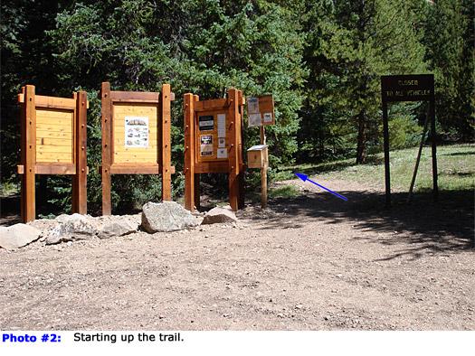
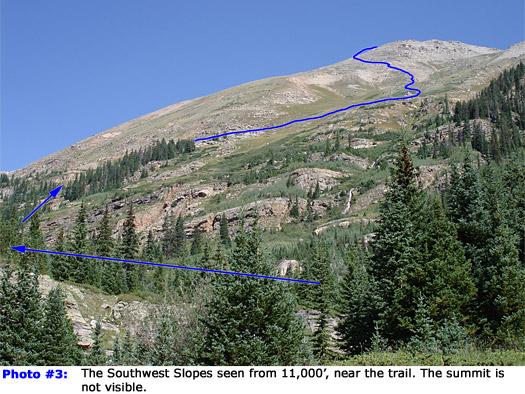
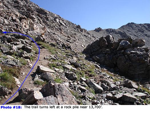
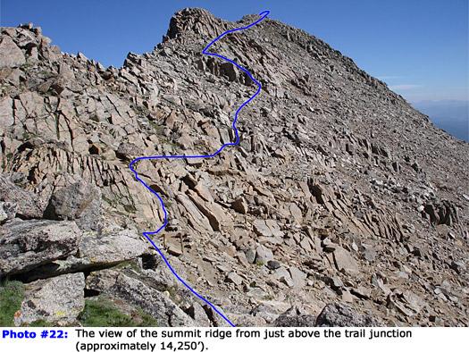
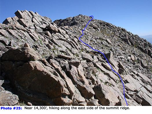
1 Route #2) Mt. Massive - Southwest Slopes Difficulty: Class 2 Ski: Advanced, D6 / R2 / III Exposure: Summit Elevation: Trailhead Elevation: Elevation Gain: Round-trip Length: Trailhead: County Sheriff: National Forest: Wilderness Area: Author: Last Updated: 14,421 feet 10,500 feet 3,950 feet 8.00 miles N. Halfmoon Creek Lake: San Isabel Mount Massive BillMiddlebrook May, 2009 TH: From U.S. 24 just south of Leadville, turn onto Colorado 300 and cross the railroad tracks. Drive 0.7 mile and turn left onto County Road 11 toward the Halfmoon Creek. After another 1.2 miles, turn right on the dirt road to Halfmoon Creek. Drive on the good dirt road (except for the usual washboard and potholes) for 5.3 miles to the Mt. Massive parking area on the right. Drive another 2 miles on the now rugged, 4WD road to a small junction. Continue straight - do not turn left on Forest Road 110J. If you have 4WD and good clearance, drive another 0.5 mile to the small, marked trailhead on the right. Route: Photo #1 is a high-angle view of the route from Mt. Elbert. From the trailhead (Photo #2), walk through the forest on the great trail for 1.25 miles. Leave the forest and weave through bushes to reach a more-open area at 11,200'. Some of the Southwest Slope can be seen after leaving the forest - Photo #3 and Photo #4. Follow the trail to the other side of a meadow (Photo #5) and reach a trail junction ( N, W) at 11,200' - Photo #6. The main trail continues west toward North Halfmoon lakes. Turn right on a new trail that climbs north and then northwest below some grassy ledges. Continue through trees and a small boulder field near 11,300' - Photo #7. Reach another, larger boulder field near 11,700' ( Photo #8) where the trail can be a bit more difficult to follow as it weaves up through the rocks. Photo #9 is a look at the upper half of the boulder field. Near 11,900', the trail heads up to the right (northeast) as it exits the boulder field under steeper terrain. Near 12,200', enter the west side of gentle terrain on the Southwest Slope and follow the trail northeast toward a rock pile - Photo #10. As you approach the pointed rock pile ( N, W), you can see much of the route up to the left. Continue all the way to the rock pile at 12,300' - Photo #11. Pass the rock pile and hike north over a small hill where you will regain your view of the route ahead. Photo #12. Keep hiking up the center of the slope to 12,900'. As shown in Photo #13, the trail now climbs more difficult terrain up to the left. Your next goal is to climb north and then northwest to gain a large ridge that runs southwest off of the summit ridge. If snow is present on the slope, take a close look at Photo #13 to determine the general location where the trail hits this ridge. Begin climbing up the steep slope - Photo #14. Photo #15 was taken during this climb and Photo #16 looks down from about 13,200'. Follow the trail as it zigzags up through rocks and, eventually, heads northwest to reach easier terrain on the broad ridge Photo #17. From the ridge, the route to the summit ridge is not obvious because you can't see the trail just follow the defined trail (Photo #18) up, and up, and up. Taken near 14,000', Photo #19 looks down on the ridge. Above 14,000', the switchbacks get closer together and the trail comes to a notch (near 14,100') on the left side of the ridge - Photo #20. Finally, the top of this ridge/slope is in view up to the right. Continue northeast to reach the "top" near 14,200'. Photo #21 looks down on the location where you should reach the top of the slope. Walk up and around a corner where the summit ridge comes into view - Photo #22. Drop slightly to reach a notch and a signed (hopefully) junction ( N, W) where the East Slopes trail comes up from the right to hit the summit ridge. Photo #23 looks back at the trail junction. Past the junction, stay right of the ridge crest and weave up through the rocks (Photo #24) to reach easier terrain on the ridge crest (Photo #25), near 14,300'. The summit is not far off, but still is not visible. Photo #26 looks back on the area. Gain a large false summit where you can finally see the summit - Photo #27. Drop to the left (west), continue to a saddle just below the true summit (Photo #28), and follow the faint trail over to the top ( N, W). From the summit, Photo #29 looks back on the summit ridge.
2 Skiing?: To ski back to the SW Slopes, drop east off the summit and traverse back to the terrain above the Massive-"South Massive" saddle: Photo #30 Just below the summit: Photo #31 Looking back at the traverse: Photo #32 Above the saddle, drop south onto the SW Slopes. The higher you drop in, the steeper the terrain. Looking down on the saddle: Photo #33 Dropping in from the saddle: Photo #34 Near 13,600': Photo #35, Photo #36 Near 13,200': Photo #37 Looking up from 12,700': Photo #38 Near 12,600', crossing to the west side of the slopes: Photo #39 Near 12,200', just above the trail: Photo #40 Notes: The last 1/2 mile of the road to this trailhead requires 4WD and should not be attempted with a passenger car. Park cars at the road junction 1/2 mile before the actual trailhead and walk up the rocky road. This is not an easy hike - from the lower meadow to the summit there's nearly 3,300' of elevation gain in 2.5 miles. IMPORTANT: This route enters the Mount Massive Wilderness area. Wilderness areas have special regulations and restrictions for party size, dispersed camping, campfires, etc. Also, dog owners should read the wilderness information carefully because some wilderness areas prohibit dogs to be off-leash and/or limit how close dogs can be to lakes and streams. If you have questions about the Mount Massive Wilderness area, please contact a U.S. Forest Service office for the National Forest(s) listed above.


3 Topo map of the route: Elevation profile:


4


5


6


7


8 ers.com, 14ers Inc. All Rights Reserved. Base USGS Topo Maps and Profiles 2004 National Geographic (NationalGeographic.com TOPO!)
Route #1) Mt. of the Holy Cross - North Ridge
 Mt. of the Holy Cross - North Ridge") Climbing 14ers can be very dangerous, please read the Mountaineering Safety Page and make sure you have a map+compass and can use them effectively, without the help of electronic devices. Route #1) Mt.
Climbing 14ers can be very dangerous, please read the Mountaineering Safety Page and make sure you have a map+compass and can use them effectively, without the help of electronic devices. Route #1) Mt.
Route Combo) Mt. Bierstadt - Bierstadt, Sawtooth, Evans
 Mt. Bierstadt - Bierstadt, Sawtooth, Evans") Climbing 14ers can be very dangerous, please read the Mountaineering Safety Page and make sure you have a map+compass and can use them effectively, without the help of electronic devices. Route Combo)
Climbing 14ers can be very dangerous, please read the Mountaineering Safety Page and make sure you have a map+compass and can use them effectively, without the help of electronic devices. Route Combo)
playwinterpark.com Off The Beaten Path Hikes Hiking Recommendations for the Adventurous Hiker
 playwinterpark.com Off The Beaten Path Hikes Hiking Recommendations for the Adventurous Hiker Hike: Devil s Thumb (difficult) Length: 3.93 miles one-way Elevation: Trailhead 9609 Destination 12,236 Trailhead
Lava Mountain Trail Distance: Elevation Range: Trail Type: Difficulty: Season: Driving Distance: Driving Time: USGS Maps: Pros Cons
 Lava Mountain Trail Distance: 13.4 miles (including the side trip to North Star Lake) Elevation Range: 5900'-8330' Trail Type: singletrack Difficulty: moderate Season: late June-October Driving Distance:
Grizzly Peak A - East Ridge July 15, 2012
 Grizzly Peak A - East Ridge July 15, 2012 Difficulty: Difficult Class 2/Class 3 Upper Elevation: 13,995 feet Trailhead Elevation: 11,360 feet Elevation Gain: 3,000 feet Round-trip Length: 6.0 miles Trailhead:
CIEC 9 PEAKS AWARD SUPPLEMENT POSSIBLE ROUTES FOR THE 9 PEAKS AWARD TRIP
 CIEC 9 PEAKS AWARD SUPPLEMENT POSSIBLE ROUTES FOR THE 9 PEAKS AWARD TRIP As you plan your trip, be aware of 3 regulations in this wilderness: 1. Camp only in designated campsites. 2. No campfires allowed.
County Line trail - Miller Peak to Little Navaho
 County Line trail - Miller Peak to Little Navaho 7-17-2008 This hike features a portion of the County Line trail in the Teanaway that receives extremely little use despite offering a spectacular ridge-run
CAMELBACK MOUNTAIN: CHOLLA TRAIL
 CITY OF PHOENIX :: Camelback Mountain: Cholla T rail 21 CAMELBACK MOUNTAIN: CHOLLA TRAIL IN BRIEF Camelback Mountain is the tallest point in the city of Phoenix. From the 2,704-foot summit of Camelback,
Trail Phasing Plan. Note: Trails in the Clear Creek Canyon area (Segments will be finalized in the future to minimize wildlife impacts
 Note: Trails in the Clear Creek Canyon area (Segments 2 5 and a future JCOS connection) will be finalized in the future to minimize wildlife impacts Trail Phasing Plan P Parking 3 Easy Trail Intermediate
Hiking Las Vegas.com
 Hike: Mt. Wilson via First Creek Canyon route Trailhead: First Creek marked Distance: 10 miles up and back Elevation gain: 3,400 feet Elevation of Peak: 7,070 feet Time: 7 to 9 hours (up and back) Difficulty:
Bradshaw Trails Series
 Bradshaw Trails Series Curtis James Troop 7014 Curtis.James@erau.edu My Motto: Never get lost! Hiking Rules Bradshaw Hiking Patch Series Hiking Tools Hiking Rules Hiking Merit Badge* Take five 10-mile
Mt. Massive Southwest Slopes
 Mt. Massive Southwest Slopes Difficulty: Class 2 Exposure: Summit Elevation: 14,421 feet Trailhead Elevation: 10,500 feet Elevation Gain: 4,050 feet Round-trip Length: 8.00 miles Trailhead: N. Halfmoon
beach. Make the ford and follow the trail out to the junction with Red Creek Tr in an open grassy area.
 Description: This is a moderate to slightly strenuous 22.8 mile backpack (add 2.6 miles if you do the packless out and back to the Lion s Head) that will have you exploring nearly every thing that is The
Mt. Elbert East Ridge
 Mt. Elbert East Ridge Difficulty: Class 1 Exposure: None Summit Elev.: 14,440 feet Trailhead Elev.: 10,400 feet Elevation Gain: 4,100 feet Roundtrip Length: 8.5 miles Trailhead: South Elbert (near Twin
Tiger Mountain State Forest:
 98 60 hikes within 60 miles: SEATTLE 20 Tiger Mountain State Forest: West Tiger Mountain Three Loop i KEY AT-A-GLANCE INFORMATION Length: 5.1 miles round-trip Configuration: Loop Difficulty: Moderate difficult
TUPPER DESIGNATED ACCESS ROUTE
 TUPPER DESIGNATED ACCESS ROUTE 1 FOR ACCESS/EGRESS TO CONNAUGHT, LOOKOUT, STONE ARCH, PORTAL PATHS AND TUPPER TRAVERSE EGRESS Length: 2.6km Vertical Gain: +162m / -83m (Values are for access. For egress,
Guide Book Excerpts. Wham Ridge 2006
 Guide Book Excerpts Wham Ridge 2006 Approach: Molus Lake / Elk Park / Vestal Creek Roach and Roach Description Take the Durango & Silverton Narrow Gauge train from either Durango or Silverton and get off
GOLDEN EARS PROVINCIAL PARK
 GOLDEN EARS PROVINCIAL PARK Trail Information as of October 10 th 2015 Do not underestimate the mountainous wilderness of Golden Ears Provincial Park. The combination of rugged terrain and rapidly changing
San Luis Obispo. Bishop Peak Felsman Loop Eagle Rock Maino Open Space Poly Canyon Poly P Other Areas
 San Luis Obispo Bishop Peak Felsman Loop Eagle Rock Maino Open Space Poly Canyon Poly P Other Areas 1 JCT. ELEV. 72 400 00 0 FELSMAN LOOP GATE LOOP RIDGE 600 FENCE JCT. ELEV. 860 1000 1200 BISHOP PEAK
Trail Beginning Elevation: 7553 ft The Poison Creek Trailhead is located at the end of National Forest Road 646E (NF-646E).
.") West Mountain Trails Poison Creek Trail #134 Length: 2.9 miles (4.7 km) Difficulty Horseback: A good trail for the first time west mountain rider, some steep sections Hiking: Most Difficult USGS Maps:
West Mountain Trails Poison Creek Trail #134 Length: 2.9 miles (4.7 km) Difficulty Horseback: A good trail for the first time west mountain rider, some steep sections Hiking: Most Difficult USGS Maps:
Mt. Sneffels (from Yankee Boy Basin) - A Cool Fourteener
 - A Cool Fourteener") Mt. Sneffels (from Yankee Boy Basin) - A Cool Fourteener Difficulty: Difficult Class 3 Exposure: Summit Elev.: 14,150 feet Trailhead: Yankee Boy Basin Climbers: Rick Crandall; Shan Stuart; Laura Welch
Mt. Sneffels (from Yankee Boy Basin) - A Cool Fourteener Difficulty: Difficult Class 3 Exposure: Summit Elev.: 14,150 feet Trailhead: Yankee Boy Basin Climbers: Rick Crandall; Shan Stuart; Laura Welch
Piestewa Peak/Dreamy Draw Trail Guide
 Piestewa Peak/Dreamy Draw Trail Guide Trail #1A - Perl Charles Memorial Trail Length: 4.8 miles Elevation: 2,200 ft. - 1,340 ft. Difficulty: Moderate to difficult The Perl Charles trailhead is located
Anderson Mt. Proposed Wilderness Additions to the Rogue-Umpqua Divide Wilderness-- T30S R3E (mostly) Sections 4 & 9, and T29S R3E Section 33
 Sections 4 & 9, and T29S R3E Section 33") Anderson Mt. Proposed Wilderness Additions to the Rogue-Umpqua Divide Wilderness-- T30S R3E (mostly) Sections 4 & 9, and T29S R3E Section 33 When the 35,701 acre Rogue-Umpqua Divide Wilderness was designated
Anderson Mt. Proposed Wilderness Additions to the Rogue-Umpqua Divide Wilderness-- T30S R3E (mostly) Sections 4 & 9, and T29S R3E Section 33 When the 35,701 acre Rogue-Umpqua Divide Wilderness was designated
Guthega to Mt Twynam. 2183m. 1583m. 6 hrs 45 mins 14.8 km Return. Experienced only. 913m
 Guthega to Mt Twynam 6 hrs 45 mins 14.8 km Return Experienced only 5 913m This walk starts from Guthega and makes its way along the Snowy River to the Illawong Lodge, via the Blue Cow Creek flying fox.
Skiing and Snowshoes on Un-groomed Fernan Saddle Terrain
 Skiing and Snowshoes on Un-groomed Fernan Saddle Terrain Three ski or snowshoe routes are available from the Fernan Saddle Parking Lot which either do not cover routes ordinarily groomed for snow machine
HIKING IN THE CANADIAN ROCKIES
 HIKING IN THE CANADIAN ROCKIES Distance Time Elevation y MORAINE LAKE TRAILS THE ROCKPILE 0.8 km (0.5 mi) 20 min 30 m (98 ft) Located adjacent to the Lodge, the short interpretive trail up the Rock Pile
Mount Daly a Most Prominent Peak via South Ridge
 Mount Daly a Most Prominent Peak via South Ridge Difficulty: Class 3 Exposure: Exposed in places along the ridge Summit Elevation: 13,305 Elevation Gain: 4100 from trailhead; 1800 from Capitol Lake camp
(west) onto Charleston Boulevard. Drive 16 miles on Charleston and turn right into Red Rock
 onto Charleston Boulevard. Drive 16 miles on Charleston and turn right into Red Rock") Hike: North Peak and Ice Box Overlook up and back Trailhead: 2.5 miles up the Rocky Gap Road not mark Distance: 5 miles round trip Elevation gain: 2,694 feet Elevation Peak: 7,094 feet Time: 3 to 5 hours
Hike: North Peak and Ice Box Overlook up and back Trailhead: 2.5 miles up the Rocky Gap Road not mark Distance: 5 miles round trip Elevation gain: 2,694 feet Elevation Peak: 7,094 feet Time: 3 to 5 hours
Guide Book Excerpts From Colorado Hut to Hut, Volume 1 Northern & Central Regions, by Brian Litz
 Guide Book Excerpts From Colorado Hut to Hut, Volume 1 Northern & Central Regions, by Brian Litz Sangree M. Froelicher Hut HUT 11,630 ELEVATION DATE BUILT 1998 SEASONS Thanksgiving through April 30 (winter);
Mount Kilimanjaro Climbing via Rongai Route 8 day-itinerary
 Mount Kilimanjaro Climbing via Rongai Route 8 day-itinerary Total hiking distance: Approximately 70 kms The Rongai route ascends Kilimanjaro from the north-eastern side of the mountain, along the border
COURSE DESCRIPTION AND DIRECTIONS
 COURSE DESCRIPTION AND DIRECTIONS START TO BOUNTIFUL B (MILE 0 to MILE 17.05) From the start at East Mountain Wilderness Park, go past the green metal gate of East Mountain Wilderness Park and follow the
Erskine Creek via Pisgah Rock and Jack Evans
 Erskine Creek via Pisgah Rock and Jack Evans 4 hrs 30 mins 7.1 km Circuit Very experienced only 6 421m This walk visits some great lookouts and explores the lower section of Erskine Creek. Most of the
YOSEMITE ON HORSEBACK: THREE RIDES ALONG TIOGA ROAD Cindy Casey White Wolf Area, May Lake Loop, Ragged Peak Loop
 YOSEMITE ON HORSEBACK: THREE RIDES ALONG TIOGA ROAD Cindy Casey White Wolf Area, May Lake Loop, Ragged Peak Loop The high country along Tioga Road presents us with some of the most dramatic scenery in
C E N T R A L C A T S K I L L S
 120 C E N T R A L C A T S K I L L S Central Catskills Once out of the southern parts of the Catskills, the Long Path enters the more well traveled and civilized regions. The trail joins the Devil s Path,
Marilla Reservoir to Chestnut Ridge via Marilla Trails and Bullis Hollow Trail east to west
 USGS topographic maps useful to this hike are the Bradford and Stickney 7.5 minute sectionals. These notes are designed to assist in identifying distance and location using geophysical and man-made characteristics
CRANBERRY. Introduction
 Introduction Introduction The Cranberry Boulders are a group of 60 problems set in a beautiful mossy forest above the Cranberry Creek. The boulders are located approximately 36km south of Revelstoke on
White Mountain Wilderness Trails
 The area in which these hikes are located is rugged high mountain country along the Mogollon Rim. This famous eastwest escarpment separates Arizona's high plateau from the basin and range below. These
Itinerary Overview. Continental Divide Alpine Backpacking 22 days Ages Course Description
 Itinerary Overview Continental Divide Alpine Backpacking 22 days Ages 16-18 Course Description Welcome, you re in for an experience of a lifetime! Imagine hiking through rolling forests, sharing alpine
L U N C H C R E E K T R A I L GLACIER NATIONAL PARK
 D I R T I N M Y S H O E S L U N C H C R E E K T R A I L GLACIER NATIONAL PARK Lunch Creek "Secret" Hike This short hike on the Lunch Creek Trail will knock your socks off! It's the perfect mix of length,
Staunton River Trail to Hoover Camp and Fork Mtn. Relay Tower (Based on September 18, 2013 hike by Ron Singleton, Fredericksburg, Va.
 Staunton River Trail to Hoover Camp and Fork Mtn. Relay Tower (Based on September 18, 2013 hike by Ron Singleton, Fredericksburg, Va.) The President's Cabin (The "Brown" House) at Camp Hoover. Sign on
Garibaldi Provincial Park Trail Conditions
 Garibaldi Provincial Park s August 2, 2018 Garibaldi Park is located in the coast mountain wilderness and the weather can be severe and unforgiving. Be well prepared, properly equipped and informed before
Location: Height: Access: Distance: Elevation: Season: Difficulty: Lat/Long: Directions:
 Upper Eagle Falls Upper Eagle Falls (~20 ft.) is a short hike up from the roadside at the Eagle Falls picnic area. It is very difficult to get a parking spot here during the day, so it is recommended to
Maroon Peak. Climbers: Rick Crandall; Rick Schultz and Andy Mishmash with his dog Stormy Oct 11, 2012
 Difficulty: Class 3 Exposure: Summit Elev.: 14,156 feet Trailhead Elev.: 9,590 feet Elevation Gain: 4,800 feet RT Length: 12.00 miles Trailhead: Maroon Lake Maroon Peak Climbers: Rick Crandall; Rick Schultz
Royal Gorge Far Out Trail to Le Point
 Royal Gorge Far Out Trail to Le Point Direction to trailhead: From East Ridge Campground: Drive west from Canon City on US 50 to County Road 3A, the entrance road to the Royal Gorge Park. Turn left onto
Weminuche Wilderness, September 2007
 Backpacking Itinerary Weminuche Wilderness, September 2007 Day Route 1 Drive to Missionary Ridge trailhead, hike to City Reservoir 2 Hike over Silver Mesa, Trimble Pass, Columbine Pass, and into Chicago
Mindful Mountain Hiking Program
 Mindful Mountain Hiking Program Want to head for the hills? Join the Mindful Mountain Hiking Program for the summer and early autumn. Day hikes in Kananaskis Country and the Rockies are led by ACMG Day
Trekking at Peuma Hue
 Trekking at Peuma Hue Peuma Hue is a paradise for those who love hiking and trekking. A large variety of trails cross pristine forest, ancient rocks and stunning waterfalls with beautiful views over the
Camp Jack Wright PERMANENT ORIENTEERING COURSE (2004)
") Camp Jack Wright PERMANENT ORIENTEERING COURSE (2004) WHAT IS ORIENTEERING? The skill which enables a person to navigate with a map. In the competitive sport, the winner is the person who finishes in the
Camp Jack Wright PERMANENT ORIENTEERING COURSE (2004) WHAT IS ORIENTEERING? The skill which enables a person to navigate with a map. In the competitive sport, the winner is the person who finishes in the
The Nest Bouldering Guide By Marc Eveleigh Updated March 24 th, 2016
 The Nest Bouldering Guide By Marc Eveleigh Updated March 24 th, 2016 Introduction The Nest is a small bouldering area set in a neat section of canyon with a rushing stream. Originally called Mophead a
Access. Road from start point (W01) to campground (W56) Water Taxi Pick-up (W03)
 to campground (W56) Water Taxi Pick-up (W03)") WAIKAREMOANA GREAT WALK 260 Series Map: W18 Waikaremoana NZ Grid GPS: Geodetic Datum 1949 Topo50 Maps: BG39 Ruatahuna & BG40 Waikaremoana Gaps: on WGS84 Topo250 Map: Sheet 10 To get to START: Exit Taupo
WAIKAREMOANA GREAT WALK 260 Series Map: W18 Waikaremoana NZ Grid GPS: Geodetic Datum 1949 Topo50 Maps: BG39 Ruatahuna & BG40 Waikaremoana Gaps: on WGS84 Topo250 Map: Sheet 10 To get to START: Exit Taupo
Cannon Traverse via Lonesome Lake - Hi Cannon - Kinsman Ridge
 AMC April 28, 2010 Cannon Traverse via Lonesome Lake - Hi Cannon - Kinsman Ridge 0 1673 ft 2007, Appalachian Mountain Club. All rights reserved. Notes Created by AMC White Mountain Guide Online wmgonline.org
Itinerary Overview. Sawatch Range Mountaineering Ages days
 Itinerary Overview Sawatch Range Mountaineering Ages 14-16 22 days Course Description Welcome, you re in for an experience of a lifetime! Imagine hiking through rolling forests, sharing alpine meadows
Griffith Park Trail Run Trail Guide Click for
 The Griffith Park Trail Run by Hike- LosAngeles.com Griffith Park Trail Run Trail Guide Click for downloadable cell phone guide and map from EveryTrail. DISTANCE: 4.55 Miles ELEVATION: 1280' ELEVATION
Note: Coordinates are provided as Universal Transverse Mercator UTM Zone U21, North American Datum 1983 (NAD 83).
.") Northern Traverse Route Description The Northern Traverse (formerly the North Rim Traverse) is an unmarked and rugged backcountry hiking route. It is known be a demanding hike, because of its terrain and
Northern Traverse Route Description The Northern Traverse (formerly the North Rim Traverse) is an unmarked and rugged backcountry hiking route. It is known be a demanding hike, because of its terrain and
Climbing Oak and Brushy Top Mountains
 Climbing Oak and Brushy Top Mountains Story and photographs by Vann Helms www.blueridgeimpressions.org Brushy Top Mountain- February 2, 2014 Brushy top summit After a January of record breaking cold weather,
Mt. Thielsen Trip Report: April 29, 2012
 Mt. Thielsen Trip Report: April 29, 2012 Outing Organizer: Geoff Hance, with Brent McGregor Elevation Gain: 3,800 feet, over warming snow, with an exposed summit block Distance: About 9 miles round trip
Morning Star Peak Avalanche Accident
 Morning Star Peak Avalanche Accident Saturday, December 4, 2010 Date: 2010-12-13 Submitted by: Oyvind Henningsen Everett Mountain Rescue and Mark Moore NWAC Place: Morning Star Peak, north-central WA Cascades
Backpacking Trip Planning. Presenters: Dana Perry Christine Fogarty
 Backpacking Trip Planning Presenters: Dana Perry Christine Fogarty 1 Agenda New to planning trips? Location and physical trail Common terminology Trip selection & research The Trip Flow Plan What is it
TAYLOR CANYON RANCH COLORADO - ROUTT COUNTY - STEAMBOAT SPRINGS
 TAYLOR CANYON RANCH COLORADO - ROUTT COUNTY - STEAMBOAT SPRINGS Tucked up against the steep valley shaped by Mt. Pau and rising to the Routt National Forest, Taylor Canyon Ranch is an easily accessible,
Dnigi Hut. Dnigi is Dnaina for Moose. Location:
 Dnigi Hut in places. Stay on the main thoroughfare. Continue along the ridge top, going east to a pass above Knob Creek. Just beyond here look for a left turn which descends north-northwest (61,45.578,-148,52.414,2081
Road and Trail Report 04/02/2015
 U.S.D.A. FOREST SERVICE KETCHUM RANGER DISTRICT 206 SUN VALLEY ROAD P.O. BOX 2356 KETCHUM, ID 83340 (208) 622-5371 Road and Trail Report 04/02/2015 o Dry weather and a dwindling snowpack continue to bring
Mt. Eolus and North Eolus
 Mt. Eolus and North Eolus Difficulty: Class 3 Exposure: Summit Elev.: Mt. Eolus: 14,083 feet N. Eolus: 14,039 feet Camp Elev.: 11,100 feet Elevation Gain: 3,200' starting at Chicago Basin 6,300' starting
Example of the layout of a Fieldwork Atlas
 Example of the layout of a Fieldwork Atlas Example of a Worksite with multiple facilities and work goals in one area: Map Center 49 3 46 N 117 3 11 W Noname Area with typical travel route marked. Avalanche
Three Sisters Wilderness Oct. 2009
 Three Sisters Wilderness Oct. 2009 I was in Bend, OR and had the whole day to travel back to Boise so I decided to take a hike to the popular Green Lakes and summit the South Sister in Three Sisters Wilderness.
Trip Report: Backpack to East Boulder Lake in California Trinity Alps, July 7-9, 2016
 Trip Report: Backpack to East Boulder Lake in California Trinity Alps, July 7-9, 2016 Trekkers: Richard Hales, Aleece Townsend, Carol Mockridge, Rosalie Rybka, Elisabeth Zinser Day 1: Richard and Aleece
TREK THE ROCKIES ABOUT THE CHALLENGE TREK THE ROCKIES FOR HIGHLAND HOSPICE CANADA TREK DEMANDING
 TREK THE ROCKIES CANADA TREK DEMANDING ABOUT THE CHALLENGE The Canadian Rockies are justifiably world-famous for their magnificent scenery: the combination of impressive, jagged mountains, bright turquoise
Drive and Stop Routes
 Drive and Stop Routes Limantour Road 1 - easy and likely productive. From Bear Valley Visitor Center drive back out and turn left onto Bear Valley Rd. Turn left at Limantour Road (the first road). Drive
Ribbon Cliff - Ribbon Mesa text and photos by Charlie Hickenbottom
 Ribbon Cliff - Ribbon Mesa text and photos by Charlie Hickenbottom Looking for something a little different than Sage Hills or Saddlerock? Perhaps something a little wilder, a little less traveled? Look
Stein Valley Nlaka pamux Heritage Park
 Stein Valley Nlaka pamux Heritage Park - Trail Information Update and Winter Advisory November 2017 March 2018 Welcome to Stein Valley Nlaka pamux Heritage Park! **This trail update is to inform park users
Pocahontas Area Map Jasper INFORMATION CENTRES Lake Louise Field Golden Banff
 Pocahontas Miette Hot Springs Area Map Jasper Maligne JASPER Columbia Icefield Saskatchewan River Crossing INFORMATION CENTRES Banff National Park Louise Kootenay Park Lodge Yoho National Park Columbia
Quandary Peak East Ridge
 Quandary Peak East Ridge Difficulty: Class 1 / 2 June 28,2013 Exposure: Summit Elev.: 14,265 feet Trailhead Elev.: 10,850 feet Elevation Gain: 3,450 feet Roundtrip: 6.75 miles Hikers: Shan Stuart, Rick
APPENDIX D: SUSTAINABLE TRAIL DESIGN. APPENDICES Town of Chili Parks and Recreation Master Plan Update
 APPENDIX D: SUSTAINABLE TRAIL DESIGN APPENDICES Town of Chili Parks and Recreation Master Plan Update Sustainable Trail Construction Sustainable trails are defined by the US Forest Service as trails having
Sunday / Monday - Osceolas
 AMC August 3, 2015 Sunday / Monday - Osceolas 0 1737 ft 2007, Appalachian Mountain Club. All rights reserved. Notes Created by AMC White Mountain Guide Online wmgonline.org 1 Distance Time Elev Change
Crystal Lake Area Trails
 Lake Area Trails Welcome to the Lake area of the Big Snowy Mountains! This island mountain range in central Montana features peaks reaching to 8,600 feet and long, high ridges from which vistas of the
Garibaldi Provincial Park Trail Conditions
 Garibaldi Provincial Park s November 20, 2018 Garibaldi Park is located in the coast mountain wilderness and the weather can be severe and unforgiving. Be well prepared, properly equipped and informed
Stephens State Park Trails
 TRAILS OF ALLAMUCHY MOUNTAIN & STEPHENS STATE PARKS Allamuchy Mountain and Stephens State Parks contain 28 marked trails providing access to diverse landscapes for walking, hiking, biking, bird-watching,
(WP19178masl) where the left branch is taken. Within 50min 300m are ascended. Start of the track shelter. Level grassy area
 where the left branch is taken. Within 50min 300m are ascended. Start of the track shelter. Level grassy area") SOUTHERN CROSSING 260-Series: Levin S25, S26 Carterton NZ Grid GPS: Geodetic datum1949 Topo50 Map: BP33 Featherstone NZTM GPS: NZTM on WGS 84 How to get to START: The motor camp in Levin makes a good overnight
SOUTHERN CROSSING 260-Series: Levin S25, S26 Carterton NZ Grid GPS: Geodetic datum1949 Topo50 Map: BP33 Featherstone NZTM GPS: NZTM on WGS 84 How to get to START: The motor camp in Levin makes a good overnight
ID: 283 Distance: 6.2 miles Height gain: 500 Metres Map: Explore OL 19 Contributor David and Chris Stewart
 Walkingworld Wild Boar Fell ID: 283 Distance: 6.2 miles Height gain: 500 Metres Map: Explore OL 19 Contributor David and Chris Stewart Features Birds, Great Views, Hills or Fells Description: Wild Boar
Cannon and the Cannon Balls Traverse with Lonesome Lake
 AMC April 13, 2010 Cannon and the Cannon Balls Traverse with Lonesome Lake 0 1966 ft 2007, Appalachian Mountain Club. All rights reserved. Notes Created by AMC White Mountain Guide Online wmgonline.org
Climbers: Rick Crandall; Rick Peckham July 29, 2016
 Wilson Peak Southwest Ridge First Try Difficulty: Class 3 Exposure: Exposed top 600 to summit Summit Elevation: 14,017 Elevation Gain: 3800 Round Trip: 10 miles Trailhead: Rock of Ages (Silver Pick) Climbers:
Suggested Day Hikes. Mount Greylock State Reservation 3, 4 1, 2. Take a Hike! Things to remember:
 Suggested Day Hikes Mount Greylock State Reservation Take a Hike! This guide offers suggested day hike routes in two parts: 1) Year-round Hikes and 2) Seasonal Hikes (late-may to Nov.1). Use this guide
Dadder Cave and Jack Evans track
 Dadder Cave and Jack Evans track 2 Days 10.3 km Circuit Very experienced only 535m This fairly short overnight walk is a great way to explore Erskine Creek. The walking along Erskine creek is mostly off
Section 7: Pick Up Where You Left Off! S-Tree Road over the Todd Road
 2018 TRACE NOTES Helpful information for your adventure on Section 7 of the Hiker Challenge. Start Point S-Tree Rd. End Point Intersection Todd Rd. / Hale Ridge Rd. WEATHER DECISION Weather Alert!!!! Potential
FROM JUTA TO ROSHKA via Chaukhi pass
 FROM JUTA TO ROSHKA via Chaukhi pass Duration: 1-2 days The hike can take one or two days, depending on how you plan it. I will focus on the 1-day version of the trek which takes 8-9 hours and starts in
AOTA ArtTrek Locations
 AOTA ArtTrek Locations ArtTrek is a summer-long Grand County, CO art adventure. Highlighted by snow-covered mountain vistas and rolling meadows threaded with sparkling streams and rivers, numerous sites
Looking back across Emerald Lake at Wapta Mountain (on the left) and Mount Burgess (on the right):
 and Mount Burgess (on the right):") YOHO LAKE FROM EMERALD LAKE, YOHO NATIONAL PARK, BRITISH COLUMBIA, CANADA We decided to hike to Yoho Lake from Emerald Lake even though the distance is longer than the trail from Takakkaw Falls (about
YOHO LAKE FROM EMERALD LAKE, YOHO NATIONAL PARK, BRITISH COLUMBIA, CANADA We decided to hike to Yoho Lake from Emerald Lake even though the distance is longer than the trail from Takakkaw Falls (about
PERUVIAN ANDES ADVENTURES. ARTESONRAJU CLIMB 6025m (19767 ft) Grade: D+ to TD/ Technical. Routes: The two routes to climb Artesonraju are;
 Grade: D+ to TD/ Technical. Routes: The two routes to climb Artesonraju are;") PERUVIAN ANDES ADVENTURES ARTESONRAJU CLIMB 6025m (19767 ft) Grade: D+ to TD/ Technical Routes: The two routes to climb Artesonraju are; *Via the Paron Valley South East Ridge 5 days (option for 6 with
PERUVIAN ANDES ADVENTURES ARTESONRAJU CLIMB 6025m (19767 ft) Grade: D+ to TD/ Technical Routes: The two routes to climb Artesonraju are; *Via the Paron Valley South East Ridge 5 days (option for 6 with
Hiking Las Vegas.com
 Hike: Juniper Peak up and back Trailhead: Oak Creek Canyon marked Distance: 5.5 miles round trip Elevation gain: 2,200 feet Elevation peak: 6,109 feet Time: 4 to 5 hours - Up and back Difficulty: 3 Danger
13 falls to garf shelter
 AMC March 21, 2012 13 falls to garf shelter 0 7383 ft 2007, Appalachian Mountain Club. All rights reserved. Notes Created by AMC White Mountain Guide Online wmgonline.org 1 starting at Lincoln Woods Trailhead
Rogue Gorge (Mt. Stella) Roadless Area-- T30S R3E (primarily in portions of Sections 23, 26, 33, 34 & 35)
 Roadless Area-- T30S R3E (primarily in portions of Sections 23, 26, 33, 34 & 35)") Rogue Gorge (Mt. Stella) Roadless Area-- T30S R3E (primarily in portions of Sections 23, 26, 33, 34 & 35) Rogue River-Siskiyou National Forest--High Cascades Ranger District Upper, higher elevation trail
Rogue Gorge (Mt. Stella) Roadless Area-- T30S R3E (primarily in portions of Sections 23, 26, 33, 34 & 35) Rogue River-Siskiyou National Forest--High Cascades Ranger District Upper, higher elevation trail
9 December 2016 Maxwell Wolckenhauer NYS DEC State Highway 10, Suite 1 Stamford, NY Conservation.
 Conservation Education Recreation Since 1922 9 December 2016 Maxwell Wolckenhauer NYS DEC 65561 State Highway 10, Suite 1 Stamford, NY 12167 r4.ump@dec.ny.gov RE: Windham-Blackhead Range Wilderness UMP
Saturday Hike - Hancock Loop & Out
 AMC August 3, 2015 Saturday Hike - Hancock Loop & Out 0 2487 ft 2007, Appalachian Mountain Club. All rights reserved. Notes Created by AMC White Mountain Guide Online wmgonline.org 1 Distance Time Elev
A Hiking Guide to Trails in the Yuma Area
 A Hiking Guide to Trails in the Yuma Area 1 A Hiking Guide to Trails in the Yuma Area By Geo Montopoli Professor, Arizona Western College (Edition 6 April 8, 2017) Author Contact: gmontopoli@gmail.com
Non-motorized Trail Plan & Proposal. August 8, 2014
 Town of Star Valley Ranch, Wyoming and the Star Valley Ranch Association in partnership with the USDA Forest Service, Bridger-Teton National Forest, Greys River Ranger District Non-motorized Trail Plan
New Guadernales 64 miles
 Cycling Route 64 miles Region: Fredericksburg, Texas Author: Gregory L. Kagay Catalog: 1022.1 Route Elevation Profile 5,000 Feet 4,000 3,000 2,000 Center Point Slope Bat Cave Summit Piedmont de San Antonio
TriPyramids via Slide Trails
 AMC August 12, 2010 TriPyramids via Slide Trails 0 2999 ft 2007, Appalachian Mountain Club. All rights reserved. Notes Created by AMC White Mountain Guide Online wmgonline.org 1 Distance Time Elev Change
ALASKA This document is a summary of what McCarthy/Kennicott area offers.
 ALASKA 2018 The Alaska Trip in July 2018 is loosely built around two sites. The first is the Wrangell-St Elias National Park. The second is Valdez and the nearby glacier which we plan to visit. We expect
West Trails Trek Guide. Chief Pontiac Trail Credential Hikes
 West Trails Trek Guide Kensington Start Edition Chief Pontiac Trail Credential Hikes RDS.WTW.110609 WP# Dist. Accum. Dist. Accum. Feet Miles Meters Meters 1 0 0.0 0 0 2 410 0.1 125 125 3 164 0.1 150 275
Mountain Footsteps. Photo: Ric Carless
 ho: Ric Carless Road Directions Middle White River FS Roads Deep Lake and Driftwood Lake see page 101, Connor Lakes along Maiyuk Creek see page 105, and for access Top of the World rovincial ark see page
MAROON BELLS SNOWMASS WILDERNESS - COLORADO LYC ADVENTURE TRIP ITINERARY 2018
 MAROON BELLS SNOWMASS WILDERNESS - COLORADO LYC ADVENTURE TRIP ITINERARY 2018 Tuesday, July 31, 2018 3:00 6:30pm Check-in & Dinner Preparations at accommodations 3:00 to 5:00pm Staff & Camper Arrival (Airport