Mt. Sneffels (from Yankee Boy Basin) - A Cool Fourteener
|
|
|
- April Ellis
- 6 years ago
- Views:
Transcription

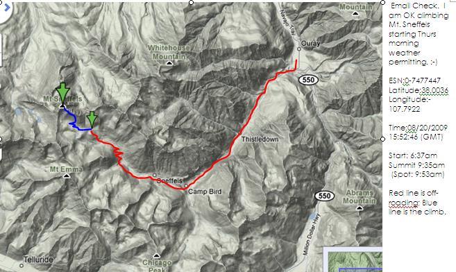
1 Mt. Sneffels (from Yankee Boy Basin) - A Cool Fourteener Difficulty: Difficult Class 3 Exposure: Summit Elev.: 14,150 feet Trailhead: Yankee Boy Basin Climbers: Rick Crandall; Shan Stuart; Laura Welch August 20, 2009 Mt. Sneffels (named after the volcano Snæfell in Iceland) is a few steps up in difficulty from the fourteeners we ve been doing. It features Class 3 rock scrambling and a difficult extended scree descent especially where there were marbles (small, round stones) on hard packed steeper slopes that were almost impossible to stand up on. However Mt. Sneffels is known as having one of the most beautiful views of all of Colorado s Fourteeners striking and impressive, caused by spires, mountains, and columnar remains of old volcanoes. We were three Shan Stuart, Laura Welch and me. We overnighted in the town of Ouray to get an early start in the morning. The approach to Ouray is reminiscent of the approach to the Swiss Alps driving from Zurich, and in fact is called the Switzerland of America due to its setting surrounded on 3 ½ sides by tall, rugged mountains. Remarkably, two-thirds of Ouray's original Victorian structures, both private and commercial, are still occupied, and have been restored. Centuries before the white man arrived, the Tabeguache Ute, a nomadic band, traveled to what would become Ouray to hunt and to soak in the sacred miracle waters. Even then, they knew the springs that simmer beneath much of Ouray were therapeutic. The town s original name was Uncompahgre, the Ute word for hot water springs. The Spanish explorers named this rugged range the San Juan Mountains. But it was the miners, flooding the region in the late 1800 s in search of silver and gold, who would forever change the face of the San Juans.

2 The legend of Chief Ouray envelops the town that bears his name. The Chief garnered the respect of the Ute Indian Nation, the U.S. Government, and the Indian nations throughout North America because of his intelligence and diplomacy. Ouray was raised in the Taos valley and was influenced by the Spanish way of life. Ouray joined his parents in Colorado at age 17, already speaking Spanish, Ute, Apache, and some English. At 35, he became the chief of the Uncompahgre Ute Tribe. Ouray believed peace The Greatest Ute Indian Chief Ouray was the best option for his people, but gold, silver, and land were at the heart of what the whites wanted, and the Ute Indians were in the way. By 1880, the year of Chief Ouray's death, the Utes had lost their land and way of life in the San Juan Mountains. The jagged peaks that zigzag around Ouray are intersected by highly mineralized veins rich in gold, silver, zinc and other metals. Naturally, these valuable metals attracted immigrant miners from all over the world. The serious "rush" started in the 1870s. Word of the huge silver strikes increased the town's population from 400 in 1876, to over 2500 by Its population has rebounded to 1000 in 2010 as a tourist mecca which is the same number of residents in 1877! Ouray's mining heyday peaked between 1883 and 1893 with most mines closing by The town evolved from a miners' camp to the Grand Madam of the San Juans with the construction of incredibly beautiful buildings. The town's architectural style was Queen Anne Victorian and is often referred to as the "Gem of the Rockies." From Ouray to Trailhead: We left town in the dark at about 5:15am in pitch dark and immediately got on the dirt road toward Yankee Boy Basin. We knew we were in for some big time off-roading, but we had Laura s Toyota FJ which was definitely the right equipment. I was the driver, because I like it. We had boulders, major ruts, steep climbs combined with hairpin turns, exposure, overhanging rock all in the dark and for over 9 miles. It definitely woke us up. This should only be attempted by a serious 4WD vehicle with high clearance and short wheelbase and preferably in daylight. We went early to get ahead of other climbers since we had so many warnings of loose rock careening down the slopes and injuring (and earlier in the summer killing one) climbers who were below others above. We did get to the trailhead first.

 and ready to")
3 (Shan and Laura) From the trailhead, at 6:35am we started our hike at sunrise. We headed towards the steep scree field you see on the right of the photo. It was chilly, but warmed up later to a beautiful Colorado blue-sky day. At about 12,600 we were at the base of Kismet" Mountain (13,694 ) and ready to head up the scree field.


4 The upper half of the slope leading up to the Lavender Col, which is kind of a saddle. Rick hated the scree and climbed up the rocks on the left, eventually joining up with the others at the base of the upper blue arrow. Laura is the tiny climber traversing the top of the col at 13,560 to join up with Rick. You can get a feel for the grade on the lower scree slope and why Rick avoided it with a Class 3 scramble up the rocky sidewall.


5 Laura met up with Shan just before meeting up with Rick to ascend the much steeper second couloir. The surrounding geology was breathtaking. Here was the next challenge a much steeper gully that ascends to 14,050, also loaded with loose rock. There is no single route up the gully we went up the right side, at times clinging to the right rock wall.

6 Rick heading up the gully with the Lavender Col in clear view below.
, we turned left to find a")


7 Near the top (approx. 30 feet from the end), we turned left to find a small "V" notch we had to get through to get to the summit. The issue here was that just past the left hand rock in the shadow was open exposure to a steep drop-off into rocks below. Rick went up first. The idea was - don t look left


8 because if you did you d see the drop-off to a rocky bottom 50 below. Here s Laura doing it with Shan s assistance.


9 Past the notch, the climbing is Class 3 scrambling, there s about 200 vertical to go to the summit. Summit Mt. Sneffels, 14,150 at 9:35 am, 3 hours from trailhead.


10 Summit view of Telluride ski slopes in the distance; Gilpin Peak (13,694 ) in foreground. Rick and Laura at the summit.


11 HAPPY BIRTHDAY SHAN! What a great birthday you had we wish you many more. Rick, Pamela, Laura and lots of doggies. The summit of Sneffels is actually pretty small - I'd say a couple square yards before it starts to drop off. The drop on the north side is especially dramatic. Surrounding views of the nearby 13ers are incredible, as are the views on the horizon of other 14ers. Uncompahgre and Wetterhorn stick out to the east, and the Wilsons, Eolus, and other southwest San Juan 14ers can all be picked out as well.
 and we wound up on a near vertical pitch trying to")

12 After about a half hour of neckturning views at the top (we were first up, but joined by a half dozen others) we headed down. That turned out to be another adventure dear Laura, feeling her oats, led us down but got off route (in fairness that s pretty easy to do up there) and we wound up on a near vertical pitch trying to locate the top of the v notch - which really gave us pause. We saw a climber coming up and asked him to spot our best route from his vantage point. He said no matter, any way you go is class 4 take any one of them. I shouted, But we re not Class 4 climbers, to which he retorted You are now and have been for a while! After we got down that pitch and down-climbed the notch we got excited we d done it. Past the notch we down-climbed the upper gully. Here s Shan on the way down towards the Lavender Col. Laura ripped down and was there waiting for us. We were advised to hike past that rock pile in the middle of the col and sidestep down the yellow bit but that was a big mistake. So we had to go off into the loose talus on the far left. Laura and Rick traversing the col to the other side of the rocks behind.


13 This took some time getting down and a few falls and bruises. The bottom is in sight, but it s still a long way down. NOTE: Mount Sneffels is a CLIMB--not a hike!

14 THE SUMMIT: The final stretch of 650 feet requires some proficiency in minor rock climbing--and caution. Be aware of rocks rolling from above and be careful not to dislodge any yourself. Wear a helmet. Do not linger on the summit--leave time to descend with care. Falls are more dangerous coming down. ATTRACTIONS AND FEATURES: This striking 14,150 foot mountain is an inviting destination for many visitors and a successful ascent can be most rewarding. It must be emphasized, however, that this peak has produced fatalities, serious injuries and hazardous rescues. It requires more planning, preparation and skill than the trails described on this website. Past all the off-road uglies and nearly back to Ouray at about 12:30pm.
15
Route #2) Mt. Massive - Southwest Slopes
 Mt. Massive - Southwest Slopes") Route #2) Mt. Massive - Southwest Slopes Difficulty: Class 2 Ski: Advanced, D6 / R2 / III Exposure: Summit Elevation: Trailhead Elevation: Elevation Gain: Round-trip Length: Trailhead: County Sheriff:
Route #2) Mt. Massive - Southwest Slopes Difficulty: Class 2 Ski: Advanced, D6 / R2 / III Exposure: Summit Elevation: Trailhead Elevation: Elevation Gain: Round-trip Length: Trailhead: County Sheriff:
Grizzly Peak A - East Ridge July 15, 2012
 Grizzly Peak A - East Ridge July 15, 2012 Difficulty: Difficult Class 2/Class 3 Upper Elevation: 13,995 feet Trailhead Elevation: 11,360 feet Elevation Gain: 3,000 feet Round-trip Length: 6.0 miles Trailhead:
Route Combo) Mt. Bierstadt - Bierstadt, Sawtooth, Evans
 Mt. Bierstadt - Bierstadt, Sawtooth, Evans") Climbing 14ers can be very dangerous, please read the Mountaineering Safety Page and make sure you have a map+compass and can use them effectively, without the help of electronic devices. Route Combo)
Climbing 14ers can be very dangerous, please read the Mountaineering Safety Page and make sure you have a map+compass and can use them effectively, without the help of electronic devices. Route Combo)
Mt. Massive Southwest Slopes
 Mt. Massive Southwest Slopes Difficulty: Class 2 Exposure: Summit Elevation: 14,421 feet Trailhead Elevation: 10,500 feet Elevation Gain: 4,050 feet Round-trip Length: 8.00 miles Trailhead: N. Halfmoon
Mount Daly a Most Prominent Peak via South Ridge
 Mount Daly a Most Prominent Peak via South Ridge Difficulty: Class 3 Exposure: Exposed in places along the ridge Summit Elevation: 13,305 Elevation Gain: 4100 from trailhead; 1800 from Capitol Lake camp
Route #1) Mt. of the Holy Cross - North Ridge
 Mt. of the Holy Cross - North Ridge") Climbing 14ers can be very dangerous, please read the Mountaineering Safety Page and make sure you have a map+compass and can use them effectively, without the help of electronic devices. Route #1) Mt.
Climbing 14ers can be very dangerous, please read the Mountaineering Safety Page and make sure you have a map+compass and can use them effectively, without the help of electronic devices. Route #1) Mt.
Climbers: Rick Crandall; Rick Peckham July 29, 2016
 Wilson Peak Southwest Ridge First Try Difficulty: Class 3 Exposure: Exposed top 600 to summit Summit Elevation: 14,017 Elevation Gain: 3800 Round Trip: 10 miles Trailhead: Rock of Ages (Silver Pick) Climbers:
Mt. Eolus and North Eolus
 Mt. Eolus and North Eolus Difficulty: Class 3 Exposure: Summit Elev.: Mt. Eolus: 14,083 feet N. Eolus: 14,039 feet Camp Elev.: 11,100 feet Elevation Gain: 3,200' starting at Chicago Basin 6,300' starting
Four Fourteeners in One Day
 Mt. Democrat: Summit: 14, 148 Mt. Cameron: Summit: 14,050 Mt. Lincoln: Summit: 14,286 Mt. Bross: Summit: 14,172 Four Fourteeners in One Day Trailhead: Trailhead Elev.: Total Elevation Gain: Roundtrip:
Hiking Las Vegas.com
 Hike: Mt. Wilson via First Creek Canyon route Trailhead: First Creek marked Distance: 10 miles up and back Elevation gain: 3,400 feet Elevation of Peak: 7,070 feet Time: 7 to 9 hours (up and back) Difficulty:
Guide Book Excerpts. Wham Ridge 2006
 Guide Book Excerpts Wham Ridge 2006 Approach: Molus Lake / Elk Park / Vestal Creek Roach and Roach Description Take the Durango & Silverton Narrow Gauge train from either Durango or Silverton and get off
Quandary Peak East Ridge
 Quandary Peak East Ridge Difficulty: Class 1 / 2 June 28,2013 Exposure: Summit Elev.: 14,265 feet Trailhead Elev.: 10,850 feet Elevation Gain: 3,450 feet Roundtrip: 6.75 miles Hikers: Shan Stuart, Rick
Mt. Elbert East Ridge
 Mt. Elbert East Ridge Difficulty: Class 1 Exposure: None Summit Elev.: 14,440 feet Trailhead Elev.: 10,400 feet Elevation Gain: 4,100 feet Roundtrip Length: 8.5 miles Trailhead: South Elbert (near Twin
C E N T R A L C A T S K I L L S
 120 C E N T R A L C A T S K I L L S Central Catskills Once out of the southern parts of the Catskills, the Long Path enters the more well traveled and civilized regions. The trail joins the Devil s Path,
Mt. Thielsen Trip Report: April 29, 2012
 Mt. Thielsen Trip Report: April 29, 2012 Outing Organizer: Geoff Hance, with Brent McGregor Elevation Gain: 3,800 feet, over warming snow, with an exposed summit block Distance: About 9 miles round trip
PERUVIAN ANDES ADVENTURES. ARTESONRAJU CLIMB 6025m (19767 ft) Grade: D+ to TD/ Technical. Routes: The two routes to climb Artesonraju are;
 Grade: D+ to TD/ Technical. Routes: The two routes to climb Artesonraju are;") PERUVIAN ANDES ADVENTURES ARTESONRAJU CLIMB 6025m (19767 ft) Grade: D+ to TD/ Technical Routes: The two routes to climb Artesonraju are; *Via the Paron Valley South East Ridge 5 days (option for 6 with
PERUVIAN ANDES ADVENTURES ARTESONRAJU CLIMB 6025m (19767 ft) Grade: D+ to TD/ Technical Routes: The two routes to climb Artesonraju are; *Via the Paron Valley South East Ridge 5 days (option for 6 with
Mt. Lindsey in the Sangre de Cristos Aug 16, 2011
 Mt. Lindsey in the Sangre de Cristos Aug 16, 2011 Difficulty: Class 3 Summit Elevation: 14,042 feet Trailhead Elevation: 10,700 feet Elevation Gain: 3,500 feet but for us it was over 4000 Round-trip Length:
GOLDEN EARS PROVINCIAL PARK
 GOLDEN EARS PROVINCIAL PARK Trail Information as of October 10 th 2015 Do not underestimate the mountainous wilderness of Golden Ears Provincial Park. The combination of rugged terrain and rapidly changing
Ellingwood Pt. via South Zapata Creek (non-standard route)
") Ellingwood Pt. via South Zapata Creek (non-standard route) Difficulty: Class 3 Exposure: Ellingwood Pt.: Elevation Gain: RT Length: Trailhead: 14,042 feet 4,800 feet (backpacking 2740 then 2060 starting
Ellingwood Pt. via South Zapata Creek (non-standard route) Difficulty: Class 3 Exposure: Ellingwood Pt.: Elevation Gain: RT Length: Trailhead: 14,042 feet 4,800 feet (backpacking 2740 then 2060 starting
21 Aug. 2004, 9:45am, at the Paradise trailhead. The day before the climb, we all took part in a one-day climbing school to refresh our skills in
 21 Aug. 2004, 9:45am, at the Paradise trailhead. The day before the climb, we all took part in a one-day climbing school to refresh our skills in walking with crampons on snow and ice, and in arresting
Maroon Peak. Climbers: Rick Crandall; Rick Schultz and Andy Mishmash with his dog Stormy Oct 11, 2012
 Difficulty: Class 3 Exposure: Summit Elev.: 14,156 feet Trailhead Elev.: 9,590 feet Elevation Gain: 4,800 feet RT Length: 12.00 miles Trailhead: Maroon Lake Maroon Peak Climbers: Rick Crandall; Rick Schultz
TUPPER DESIGNATED ACCESS ROUTE
 TUPPER DESIGNATED ACCESS ROUTE 1 FOR ACCESS/EGRESS TO CONNAUGHT, LOOKOUT, STONE ARCH, PORTAL PATHS AND TUPPER TRAVERSE EGRESS Length: 2.6km Vertical Gain: +162m / -83m (Values are for access. For egress,
Trail Phasing Plan. Note: Trails in the Clear Creek Canyon area (Segments will be finalized in the future to minimize wildlife impacts
 Note: Trails in the Clear Creek Canyon area (Segments 2 5 and a future JCOS connection) will be finalized in the future to minimize wildlife impacts Trail Phasing Plan P Parking 3 Easy Trail Intermediate
TREK THE ROCKIES ABOUT THE CHALLENGE TREK THE ROCKIES FOR HIGHLAND HOSPICE CANADA TREK DEMANDING
 TREK THE ROCKIES CANADA TREK DEMANDING ABOUT THE CHALLENGE The Canadian Rockies are justifiably world-famous for their magnificent scenery: the combination of impressive, jagged mountains, bright turquoise
MOUNTAIN BIKING THE CASCADE LOOP
 MOUNTAIN BIKING THE CASCADE LOOP By Henry Freimuth All photographs by Henry Freimuth The Cascades are on the Spanish Creek, which is a tributary of the Feather River. The Feather River was named by Spanish
Saturday, May 30, 2018 Cobra flight #632, PIC #645, 3 landings Rio San Jose, Salado Creek, Puerco Ruins, La Ventana, Nuestra Senora, Puerco Volcanos
 Saturday, May 30, 2018 Cobra flight #632, PIC #645, 3 landings Rio San Jose, Salado Creek, Puerco Ruins, La Ventana, Nuestra Senora, Puerco Volcanos Belen: 6:43 am Belen: 9:45 am Today s Airtime: 3.0 Total
Mount Kilimanjaro Climbing via Rongai Route 8 day-itinerary
 Mount Kilimanjaro Climbing via Rongai Route 8 day-itinerary Total hiking distance: Approximately 70 kms The Rongai route ascends Kilimanjaro from the north-eastern side of the mountain, along the border
playwinterpark.com Off The Beaten Path Hikes Hiking Recommendations for the Adventurous Hiker
 playwinterpark.com Off The Beaten Path Hikes Hiking Recommendations for the Adventurous Hiker Hike: Devil s Thumb (difficult) Length: 3.93 miles one-way Elevation: Trailhead 9609 Destination 12,236 Trailhead
1. Waterfall Gully Mt Lofty. 5 Of the Best Hikes in Adelaide
 Adelaide is a beautiful city, and one of the most incredible things about Adelaide is the quality of bushwalking available on the suburban fringe. It is surrounded by the Mt Lofty Ranges, and much of the
! Kilimanjaro Expedition
 ! Kilimanjaro Expedition Tanzania 2016 Climb Only: $4,350 (land costs) Feb 4-12; June 12-20; July 10-18; Aug 6-14; Sept 11-19; Dec 4-12 2016 Climb & Safari: $5,850 (land costs) Feb 4-15; June 12-23; July
18 day itinerary: ACONCAGUA Normal Route 15 day trek. T r i p I t i n e r a r y
 T r i p I t i n e r a r y HIGHLIGHTS Summit the highest mountain in South America, and the second highest of the Seven Summits Breath-taking views of the Andes Three days set aside for the summit attempt
Approximate distance: 4.7 miles For this walk we ve included OS grid references should you wish to use them. Start. End
 Approximate distance: 4.7 miles For this walk we ve included OS grid references should you wish to use them. Start End 1 2 3 4 N 5 W E S Reproduced by permission of Ordnance Survey on behalf of HMSO. Crown
CIEC 9 PEAKS AWARD SUPPLEMENT POSSIBLE ROUTES FOR THE 9 PEAKS AWARD TRIP
 CIEC 9 PEAKS AWARD SUPPLEMENT POSSIBLE ROUTES FOR THE 9 PEAKS AWARD TRIP As you plan your trip, be aware of 3 regulations in this wilderness: 1. Camp only in designated campsites. 2. No campfires allowed.
(west) onto Charleston Boulevard. Drive 16 miles on Charleston and turn right into Red Rock
 onto Charleston Boulevard. Drive 16 miles on Charleston and turn right into Red Rock") Hike: North Peak and Ice Box Overlook up and back Trailhead: 2.5 miles up the Rocky Gap Road not mark Distance: 5 miles round trip Elevation gain: 2,694 feet Elevation Peak: 7,094 feet Time: 3 to 5 hours
Hike: North Peak and Ice Box Overlook up and back Trailhead: 2.5 miles up the Rocky Gap Road not mark Distance: 5 miles round trip Elevation gain: 2,694 feet Elevation Peak: 7,094 feet Time: 3 to 5 hours
Avalanches and the Mount Whitney Basin
 Avalanches and the Mount Whitney Basin 10 April 2006 by Bob Rockwell Prelude Avalanches are a fact of life in high mountains in winter, and we take courses to find out about them. We learn how to assess
Witte Museum Tour Meyers Spring Ranch Tour Saturday, September 1, a.m. - 4 p.m.
 Witte Museum Tour Meyers Spring Ranch Tour Saturday, September 1, 2018 10 a.m. - 4 p.m. This tour is limited to 35 participants (Ages 12 and up) All minors must be accompanied by a parent or legal guardian.
TREK KILIMANJARO ABOUT THE CHALLENGE KILIMANJARO TREK - 11 DAY TANZANIA TREK RED 3
 TREK KILIMANJARO TANZANIA TREK RED 3 ABOUT THE CHALLENGE Climb the highest freestanding mountain in the world! Kilimanjaro is the highest mountain on the African continent at 5896m. Its snow-capped summit
L U N C H C R E E K T R A I L GLACIER NATIONAL PARK
 D I R T I N M Y S H O E S L U N C H C R E E K T R A I L GLACIER NATIONAL PARK Lunch Creek "Secret" Hike This short hike on the Lunch Creek Trail will knock your socks off! It's the perfect mix of length,
Note: Coordinates are provided as Universal Transverse Mercator UTM Zone U21, North American Datum 1983 (NAD 83).
.") Northern Traverse Route Description The Northern Traverse (formerly the North Rim Traverse) is an unmarked and rugged backcountry hiking route. It is known be a demanding hike, because of its terrain and
Northern Traverse Route Description The Northern Traverse (formerly the North Rim Traverse) is an unmarked and rugged backcountry hiking route. It is known be a demanding hike, because of its terrain and
Backpacking Trip Planning. Presenters: Dana Perry Christine Fogarty
 Backpacking Trip Planning Presenters: Dana Perry Christine Fogarty 1 Agenda New to planning trips? Location and physical trail Common terminology Trip selection & research The Trip Flow Plan What is it
7 DAYS RONGAI ROUTE ON KILIMANJARO ROUTE
 7 DAYS RONGAI ROUTE ON KILIMANJARO ROUTE Day 1: Drive to Kilimanjaro National Park Rongai Gate (Nale Moru), Hike to Simba Camp Drive to the attractive wooden village of Nale Moru (about 2 hours including
GIFFORD PINCHOT NATIONAL FOREST
 GIFFORD PINCHOT NATIONAL FOREST 9341 Wright Meadow 93 Spencer Meadow Spencer Butte 4247' 30 30A 19 24 80 31C Lewis River Lower Falls 5 Quartz Creek 90 Taidnapam Falls Upper Falls 31 Spencer Peak 3861'
HIKING IN THE CANADIAN ROCKIES
 HIKING IN THE CANADIAN ROCKIES Distance Time Elevation y MORAINE LAKE TRAILS THE ROCKPILE 0.8 km (0.5 mi) 20 min 30 m (98 ft) Located adjacent to the Lodge, the short interpretive trail up the Rock Pile
Witte Museum Tour Painted Shelter on the Rio Grande River Saturday June 2, :30 A.M. 3:00 P.M.
 Witte Museum Tour Painted Shelter on the Rio Grande River Saturday June 2, 2018 9:30 A.M. 3:00 P.M. This tour is limited to 35 participants (Ages 12 and up) All minors must be accompanied by a parent or
Kilimanjaro Private Trek
 Select Kilimanjaro Private Trek Mount Kilimanjaro National Park, Tanzania BEAT ABOUT THE BUSH TOURISM SERVICES Website: www.beataboutthebush.co.za E-mail: safaris@beataboutthebush.co.za Tel: +27 83 442
HORSEBACK RIDING. All rates are subject to service charges
 HORSEBACK RIDING The Local Loop Ride - A family-friendly 45-minutes to one hour ride around Dunton s east property. Perfect for children and adults who are new to riding. Easy terrain and beautiful views.
Your Guide to Mountainbiking around Atlin (yes, you can hike these trails as well)
") Your Guide to Mountainbiking around Atlin (yes, you can hike these trails as well) Foreword Thanks to the rich mining history in Atlin, the historic mining roads have become the perfect trails for recreational
Your Guide to Mountainbiking around Atlin (yes, you can hike these trails as well) Foreword Thanks to the rich mining history in Atlin, the historic mining roads have become the perfect trails for recreational
Trek2Kili P.O. Box 2112 Moshi TZ Whatsapp
 Trek2Kili P.O. Box 2112 Moshi TZ Whatsapp +255 673 360 trek2kili@gmail.com MT. KILIMANJARO MACHAME 7 DAY 6 NIGHT TREK Known as the Whisky Route, this is one of the most scenic and therefore popular routes
Sunday / Monday - Osceolas
 AMC August 3, 2015 Sunday / Monday - Osceolas 0 1737 ft 2007, Appalachian Mountain Club. All rights reserved. Notes Created by AMC White Mountain Guide Online wmgonline.org 1 Distance Time Elev Change
FROM JUTA TO ROSHKA via Chaukhi pass
 FROM JUTA TO ROSHKA via Chaukhi pass Duration: 1-2 days The hike can take one or two days, depending on how you plan it. I will focus on the 1-day version of the trek which takes 8-9 hours and starts in
Tiger Mountain State Forest:
 98 60 hikes within 60 miles: SEATTLE 20 Tiger Mountain State Forest: West Tiger Mountain Three Loop i KEY AT-A-GLANCE INFORMATION Length: 5.1 miles round-trip Configuration: Loop Difficulty: Moderate difficult
PERUVIAN ANDES ADVENTURES. EXPEDITION Climbing Alpamayo & Huascaran. PEAKS: Maparaju 5350m Alpamayo 5947m Huascaran Sur 6768m
 PERUVIAN ANDES ADVENTURES EXPEDITION Climbing Alpamayo & Huascaran PEAKS: Maparaju 5350m Alpamayo 5947m Huascaran Sur 6768m 23 days Huaraz to Huaraz Grade: Technical, physically demanding This is a comprehensive
Twin Lakes Avalanche Incident 1/31/2016
 Twin Lakes Avalanche Incident 1/31/2016 Location: Place State Published by: Dave Bingaman (PAC), George Halcom (PAC), and Kent May (PAC) Twin Lakes, Salmon River Mountains Idaho Date 01/31/2016 Time Summary
Climbing Oak and Brushy Top Mountains
 Climbing Oak and Brushy Top Mountains Story and photographs by Vann Helms www.blueridgeimpressions.org Brushy Top Mountain- February 2, 2014 Brushy top summit After a January of record breaking cold weather,
MT ASPIRING COURSE & ASCENT 2018/2019 TRIP NOTES
 MT ASPIRING COURSE & ASCENT 2018/2019 TRIP NOTES Mount Aspiring Course and Guided Ascent Course Notes All material Copyright Adventure Consultants Ltd 2018-2019 Mount Aspiring is a majestic, soaring peak
Henderson Mountain Avalanche Accident Two riders caught, one partially buried, one fully buried
 Henderson Mountain Avalanche Accident Two riders caught, one partially buried, one fully buried Custer-Gallatin National Forest 28 November 2014 Synopsis A group of 6 or 7 snowmobilers (part of a larger
Weminuche Wilderness, September 2007
 Backpacking Itinerary Weminuche Wilderness, September 2007 Day Route 1 Drive to Missionary Ridge trailhead, hike to City Reservoir 2 Hike over Silver Mesa, Trimble Pass, Columbine Pass, and into Chicago
Leaden Boot Challenge ROUTE INSTRUCTIONS
 Leaden Boot Challenge ROUTE INSTRUCTIONS Section 1 Alstonefield to Ilam From the village hall car park turn R then L and pass through the village keeping to the R to enter Church Street. Pass the Church
MT ASPIRING GUIDED ASCENT 2018/2019 TRIP NOTES
 MT ASPIRING GUIDED ASCENT 2018/2019 TRIP NOTES Mt Aspiring Guided Ascent Trip Notes All material Copyright Adventure Consultants Ltd 2018-2019 Mount Aspiring is a majestic, soaring peak and a challenging
TriPyramids via Slide Trails
 AMC August 12, 2010 TriPyramids via Slide Trails 0 2999 ft 2007, Appalachian Mountain Club. All rights reserved. Notes Created by AMC White Mountain Guide Online wmgonline.org 1 Distance Time Elev Change
MT. KILIMANJARO SHIRA ROUTE 8 days
 MT. KILIMANJARO SHIRA ROUTE 8 days Activities: Trekking Difficulty: Moderate to Adventurous Max Elevation: 5,895m/ 19,340 ft at summit Meal: Full board on trek Accommodation: Hotel in Moshi/ tent on trek
Oman Trek Trek the dramatic and beautiful scenery of Oman
 Oman Trek Trek the dramatic and beautiful scenery of Oman Discover Oman on this breath taking 5 day challenge. The mountain ranges and deserts of Oman offer spectacular trekking, and enables you to experience
San Luis Obispo. Bishop Peak Felsman Loop Eagle Rock Maino Open Space Poly Canyon Poly P Other Areas
 San Luis Obispo Bishop Peak Felsman Loop Eagle Rock Maino Open Space Poly Canyon Poly P Other Areas 1 JCT. ELEV. 72 400 00 0 FELSMAN LOOP GATE LOOP RIDGE 600 FENCE JCT. ELEV. 860 1000 1200 BISHOP PEAK
Self-Guided Walk Langdale Pikes. Start & Finish: NT car park (free to members) at Sticklebarn - on the right just beyond the New Dungeon Ghyll hotel.
 at Sticklebarn - on the right just beyond the New Dungeon Ghyll hotel.") Self-Guided Walk Langdale Pikes Key Information These mountains form a collection of spires and cliffs on the north side of Langdale. This walk visits four of the main tops Pavey Ark, Harrison Stickle,
Self-Guided Walk Langdale Pikes Key Information These mountains form a collection of spires and cliffs on the north side of Langdale. This walk visits four of the main tops Pavey Ark, Harrison Stickle,
6 DAYS MACHAME ROUTES ON KILIMANJARO
 6 DAYS MACHAME ROUTES ON KILIMANJARO Day 1: Moshi Machame camp In the morning, we depart from our base hotel at approximately 8:00 AM for the Machame village where you begin the trek. From the park entrance
Leaden Boot Challenge 2016 ROUTE INSTRUCTIONS
 Leaden Boot Challenge 2016 ROUTE INSTRUCTIONS Section 1 Alstonefield to Ilam (CP2) From the village hall car park turn R then L and pass through the village keeping to the R to enter Church Street. Pass
colorado trail SUMMER 2018
 DENVER, COLORADO 39.7392 N, 104.9903 W colorado trail trip overview With the most elevation of any state in the lower 48, Colorado is the place to play in the mountains. The stunning peaks and raging rivers
The Witte Museum Rock Art Foundation White Shaman Preserve Guided Tours
 The Witte Museum Rock Art Foundation White Shaman Preserve Guided Tours Every Saturday, September through May These tours are limited to 20 participants (ages 12 and up) All minors must be accompanied
Trail Beginning Elevation: 7553 ft The Poison Creek Trailhead is located at the end of National Forest Road 646E (NF-646E).
.") West Mountain Trails Poison Creek Trail #134 Length: 2.9 miles (4.7 km) Difficulty Horseback: A good trail for the first time west mountain rider, some steep sections Hiking: Most Difficult USGS Maps:
West Mountain Trails Poison Creek Trail #134 Length: 2.9 miles (4.7 km) Difficulty Horseback: A good trail for the first time west mountain rider, some steep sections Hiking: Most Difficult USGS Maps:
CHALLENGE OVERVIEW. May - October
 CHALLENGE OVERVIEW A land of incredible history and culture, Morocco is a melting pot of Berber, Arab and European influences. The country is perched between the Atlantic Ocean and the Sahara Desert in
Mt. Kilimanjaro Trek. WanderTours P.O. Box Seattle WA Itinerary dates: January 23 - February 1, 2019 Tour Escort: Beth Whitman
 WanderTours P.O. Box 16102 Seattle WA 98116 Mt. Kilimanjaro Trek Itinerary dates: January 23 - February 1, 2019 Tour Escort: Beth Whitman HIGHLIGHTS The six-day Machame Route to Uhuru Peak, considered
Adventure Travel Trip Itinerary
 Adventure Travel Trip Itinerary Mt. Kilimanjaro & Mt. Meru Climbs, Tanzania July 8 23, 2017 Leader: Bill Blazek Date Activity (distances are approximate) Accommodation, Notes Meals 1 Saturday July 8, 2017
Telluride-to-Moab Alternative Singletrack Options
 Telluride-to-Moab Alternative Singletrack Options Day 1 Day 1 Alternate 1: Galloping Goose to Deep Creek. 18.4 miles, ascent 3,530ft, descent 1,388ft. This is fun, flowey, moderate to intermediate singletrack
Mount Kilimanjaro Climbing via Marangu Route 6 day-itinerary
 Mount Kilimanjaro Climbing via Marangu Route 6 day-itinerary (For the 5-day route, simply exclude the additional acclimatisation day at Horombo hut - day 3 on the itinerary below.) Total hiking distance:
White Mountain Wilderness Trails
 The area in which these hikes are located is rugged high mountain country along the Mogollon Rim. This famous eastwest escarpment separates Arizona's high plateau from the basin and range below. These
The temperature is nice at this time of year, but water is already starting to be scarce.
 In March of 2003, Scott Morrison and I went backpacking in the Grand Canyon. The temperature is nice at this time of year, but water is already starting to be scarce. Another issue with this time of year
HB/VS-078 Üssers Barrhorn
 HB/VS-078 Üssers Barrhorn Paul HB9DST, August 23, 2015 Summary: This was a HB9SOTA club project, an activation of the highest summit in Europe you can hike up without ropes or other equipment. The headline
Saturday Hike - Hancock Loop & Out
 AMC August 3, 2015 Saturday Hike - Hancock Loop & Out 0 2487 ft 2007, Appalachian Mountain Club. All rights reserved. Notes Created by AMC White Mountain Guide Online wmgonline.org 1 Distance Time Elev
Excelsior Pass Avalanche Accident January 1, 2008
 Excelsior Pass Avalanche Accident January 1, 2008 Accident Summary Time: 1 January 2008, approximately 13:00 hrs Location: Near Excelsior Pass to east of Church Mt, Northern Washington Cascades WA Activity:
Hiking the Haute Route. 11 Days
 Hiking the Haute Route 11 Days Hiking the Haute Route Experience the Haute Route or "High Road" of the Alps on this challenging itinerary designed for serious trekkers. The Haute Route connects Mont Blanc
The rewards more than make up for the efforts of seeing the country this is a truly unforgettable trek.
 MADAGASCAR TREK ORANGE 2 ABOUT THE CHALLENGE This exciting trek takes us to remote Madagascar, where spectacular scenery and amazing wildlife awaits! From canyons and gorges to bush-covered plains and
MT KILIMANJARO TREK- LEMOSHO ROUTE
 #Trekking MT KILIMANJARO TREK- LEMOSHO ROUTE 10 Days 9 Nights Overview Take the challenging and less-travelled Lemosho route up to the highest peak in Africa, considered by many to be the most beautiful
beach. Make the ford and follow the trail out to the junction with Red Creek Tr in an open grassy area.
 Description: This is a moderate to slightly strenuous 22.8 mile backpack (add 2.6 miles if you do the packless out and back to the Lion s Head) that will have you exploring nearly every thing that is The
THE WITTE MUSEUM ROCK ART FOUNDATION 24th ANNUAL RENDEZVOUS February 23-25, 2018
 THE WITTE MUSEUM ROCK ART FOUNDATION 24th ANNUAL RENDEZVOUS February 23-25, 2018 Participation is limited to 130 guests. The format of the Rock Art Rendezvous will focus on site tours of the remarkable
THE THREE PEAKS OF TANZANIA
 THE THREE PEAKS OF TANZANIA Longido, Mt Meru, and Kilimanjaro in 13 days Day 1 Arrival Longido approx 10kms trekking FBA can arrange your flights to Nairobi or Kilimanjaro. If booking your own flights,
Aconcagua Leadership and Guide Training Course
 Aconcagua Leadership and Guide Training Course Cerro Aconcagua is located in the central Andes of Argentina near the border with Chile. At 22,841ft (6,962m), it is one of the seven summits and the only
Cotopaxi (5.897mts) & Chimborazo s (6.268mts) Summit
 & Chimborazo s (6.268mts) Summit") Cotopaxi (5.897mts) & Chimborazo s (6.268mts) Summit Day 1: Arrive in Quito, transfer to hotel. Day 2: Acclimatisation day in Quito (city tour) Duration: 3 4 hours Enjoy a leisurely tour through Colonial
Cotopaxi (5.897mts) & Chimborazo s (6.268mts) Summit Day 1: Arrive in Quito, transfer to hotel. Day 2: Acclimatisation day in Quito (city tour) Duration: 3 4 hours Enjoy a leisurely tour through Colonial
MOUNT KILIMANJARO TREK
 TANZANIA TREK EXTREME ABOUT THE CHALLENGE Climb the highest freestanding mountain in the world! Kilimanjaro is the highest mountain on the African continent at 5896m. Its snow-capped summit rises high
Adventure Travel Trip Itinerary
 s of trip: August 20 - September 4, 2019 Aug 20 (Tues) Travel to Geneva, Switzerland 1 Aug 21 (Wed) Arrival in Geneva Please plan to arrive before 2 p.m. local time, to allow enough time to get through
Mountaineering- Mt Kilimanjaro
 Mountaineering- Mt Kilimanjaro Mount Kilimanjaro is the highest mountain in Africa and is one of the seven summits. This mountain speaks for itself with several thousand visitors summiting each year. We
Snowmass Mountain. Climbers: Brett Crandall; Rick Crandall; Rick Peckham August 11, 2014
 Snowmass Mountain Difficulty: Class 3 & 4 Exposure: Summit Elev.: 14,092 feet Trailhead Elev.: 8,400 feet Elevation Gain: 5,800 total; 3200 from Snowmass Lake RT Length: 22.00 miles total; 5 miles from
CHALLENGE OVERVIEW. ACCOMMODATION. You will be accommodated in friendly, simple hotels and tents whilst on the mountain.
 CHALLENGE OVERVIEW Mount Kilimanjaro is one of the seven Natural Wonders of the World and for many people, standing on its summit is a life-long ambition. The snow-capped peak was first reached by German
Kit Carson-Challenger Ridge Trail Project Annual Performance Report-2014 October 22, 2014
 1 Kit Carson-Challenger Ridge Trail Project Annual Performance Report-2014 October 22, 2014 Willow Lake and Kit Carson Peak 2 SUMMARY The Rocky Mountain Field Institute began Phase 1 of a multi-phase,
Images Made in the Mountains
 IMAGES MADE IN THE MOUNTAINS CHUCK GRAHAM Mountain camp below Mount Tyndall at sunrise in the Eastern Sierra, CA Images Made in the Mountains Chuck Graham I left my truck at 1:00 am at the top of the Whitney
UPDATED: Verdon Gorge & GR4: Europe's Grand Canyon
 UPDATED: Verdon Gorge & GR4: Europe's Grand Canyon UPDATED: Verdon Gorge & GR4: Europe's Grand Canyon UPDATED: Verdon Gorge & GR4: Europe's Grand Canyon 1295 Difficult Hike the Grand Canyon of Europe!
Piestewa Peak/Dreamy Draw Trail Guide
 Piestewa Peak/Dreamy Draw Trail Guide Trail #1A - Perl Charles Memorial Trail Length: 4.8 miles Elevation: 2,200 ft. - 1,340 ft. Difficulty: Moderate to difficult The Perl Charles trailhead is located
Ribbon Cliff - Ribbon Mesa text and photos by Charlie Hickenbottom
 Ribbon Cliff - Ribbon Mesa text and photos by Charlie Hickenbottom Looking for something a little different than Sage Hills or Saddlerock? Perhaps something a little wilder, a little less traveled? Look
Dnigi Hut. Dnigi is Dnaina for Moose. Location:
 Dnigi Hut in places. Stay on the main thoroughfare. Continue along the ridge top, going east to a pass above Knob Creek. Just beyond here look for a left turn which descends north-northwest (61,45.578,-148,52.414,2081
Trek2Kili P.O. Box 2112 Moshi TZ Whatsapp
 Trek2Kili P.O. Box 2112 Moshi TZ Whatsapp +255 673 360 trek2kili@gmail.com MT. KILIMANJARO SHIRA 8 DAY 7 NIGHT TREK Very similar to Lemosho route, however it starts at 3,600 meters and is therefore not
Windom Peak. Climbers: Rick Crandall; Rick Peckham August 26, 2017
 Windom Peak Difficulty: Class 3 Exposure: Significant exposure at summit Summit Elevation: 14,082 Elevation Gain: 6000 from Needleton; 3000 from Chicago Basin camp at 11,100 Round Trip: 17 miles from Needleton;