Mt. Eolus and North Eolus
|
|
|
- Charity Burke
- 5 years ago
- Views:
Transcription

1 Mt. Eolus and North Eolus Difficulty: Class 3 Exposure: Summit Elev.: Mt. Eolus: 14,083 feet N. Eolus: 14,039 feet Camp Elev.: 11,100 feet Elevation Gain: 3,200' starting at Chicago Basin 6,300' starting at Needleton drop from Train RT Length: 5 miles starting at Chicago Basin 19 miles starting at Needleton Trailhead: Needleton drop off from Silverton train Climbers: Rick Crandall, Rick Peckham August 5, 2014 updated Sept 2 This is a two-part story. Our first attempt was August 5 th when we turned around at the catwalk due to poor weather conditions. Second attempt was successful September 2 nd. Mt. Eolus is a challenging mountain in the beautiful but rugged San Juan Range. It is named after the Greek god of the wind Aeolus, whom Zeus had made keeper of the Winds. Getting to it is the first challenge as it involves driving 5 hours from Aspen to either Durango or 4 hours to Silverton and then taking the Denver & Rio Grande narrow-gauge train (in operation since 1880!) that operates between Durango and Silverton. We paid the extra hikers fee for it to stop in the middle at a ghost town called Needleton where you jump off with your full pack. The train leaves immediately and you then backpack 7 miles and 3000 up to the Chicago Basin. There you set camp and get ready for a climb early the next morning, weather permitting. We d been to Chicago Basin two years ago with my brother Wayne, my son Brett and friend Rick Peckham. At that time we successfully summited Sunlight Peak, a hard 14er that Brett helped us to get up, see: ). The history of the train is also in that story. This time, Rick Peckham came down again for a month from Alaska to be my climbing partner on several peaks. For our 2 nd and successful attempt, we decided to chance taking the train from Silverton (shorter drive from Aspen) which let us off at Needleton at 3:40pm. That gave us only 4 hours to backpack to the Chicago Basin, find and set camp before dark. Rick P. raced ahead of me and got both our tents up in time for me to haul in at faster than my normal speed right at 7pm as the sun set. Rick P. in Silverton


2 The town of Silverton (at 9305 ) gives the visitor a great feeling of authenticity for an old-time Colorado silver mining town. The buildings are authentic, although now mostly selling T shirts. The town, population 530, is now included in a federally designated National Historic Landmark District. Silverton no longer has active mining, but subsists on tourism. Silverton framed by Silverton Mountain behind Silverton Mountain was the setting for some of Shaun White s 2010 Olympic training where Red Bull set up a private and initially secret half-pipe for the snowboarder. These headstones are a riot a cemetery right in the middle of the oldest part of town.


3 Rick C. with the steam locomotive at the station ready for the ride. The drop-offs along the train route are quite amazing, particularly given that the route was carved out of the side of the Animas River gorge over 100 years ago!


4 Unloading our packs at the Needleton ghosttown stop. That car was old! We heard the day before the train picked up 90 coming out of the Basin and when we dropped off there were 63 waiting to get on the train! Our chosen date was September 2, Labor Day. We d heard that Chicago Basin was popular not only for the 14ers accessed there but as a recreational camping spot. We figured we d miss the crowds, by arriving at the end of the long weekend. The strategy paid off the next day for our climb we were the ONLY climbers on the mountains. Incredible. Rick P. at the bridge over the Animas River. The bridge and a few old structures are mostly what s left of Needleton.


5 I got to Chicago Basin ½ hour after Rick P. and that s with my pack weighing 30 lbs. and his clocked in at 40 lbs. He had both tents set up and coffee ready to heat! 13ers and 14ers are in the background. The wild goats native to the Basin watched carefully they know that some campers carelessly leave their food around. That has caught many a camper short of food, stolen by the goats or the marmots. We hadn t heard of many bear problems at this elevation. We camped at 11,100. We set camp but they were watching!


6 in our first attempt we witnessed an extended lightning and thunderstorm during the night lighting up our tents. This time the weather was perfect, skies clear and starry. Taking that as a hopeful sign, we hit the route at 6:00 am in the dark. Rick P. taking a momentary stop 1300 up from camp at Twin Lakes. The views in the San Juans are stunning! They re known to be the most beautiful range in the state of Colorado.


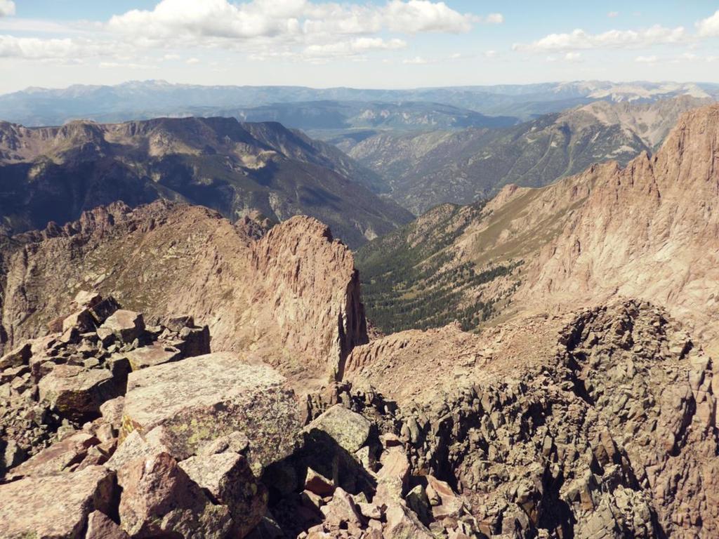
7 This is most of the remaining route from Twin Lakes to get to Mt. Eolus. There are several segments to the climb involving rocks, tilted slab-walking and then the crux of the climb, namely the Catwalk and final rock climb to the Eolus summit. Rick P. at the slabs they were grippy underfoot except where wet or steep in places.


8 Now this goat had no problems with the slabs or any of the rocky features. Past the slabs there was still another 800 feet up to get to the Catwalk. This is a very narrow ridge (the yellow arrow) with steep dropoffs on both sides that starts about 2 feet wide and narrows from there. It s a head trip.


9 On our earlier attempt, we met another three climbers at the start of the Catwalk the two younger ones went on, the third just sat down and freaked out: I ve been wanting to see this feature for two years, and now that I do, I m not doing that. It s not that it s technically difficult, but the exposure on both sides is dramatic, so it can be a mental challenge to go across. Rick C. starting the Catwalk on our earlier attempt just as the weather started to descend upon us. Rick P. The scene quickly became surreal. It looked like a trip into a space-walk with total mystery on the other end. How s this shot for drama Rick P. pushed further, tight-roping the narrow bits, but then visibility went to about zero so we turned around (earlier attempt) without going for the summit.

10 On our Sep 2 second attempt the weather was perfect. Here is Rick C. heading towards some of the narrow parts of the Catwalk.


11 Here I m thinking: Maybe four points (hands and feet) on the edge is a better plan!). That s North Eolus in the background. The route instructions were, from the end of the Catwalk traverse left under some cliffs and then climb up in a zig-zag line staying in the middle of the face if you go too far left or right you re into even more serious conditions. We got to the end of the catwalk and looked up at the remaining climb. This picture doesn t do it justice, but.


12 This picture does! That s a climber in red in the middle of that face for perspective. Rick C. starting the Class 3 climb up the Eolus South face. The orange ribbon is tied to a cairn meant to show the way but it turns out they showed several ways. One of them led us straight to the ridge we were supposed to avoid so we got off it pretty quick.


13 and here is Rick P. leading up an even steeper bit. I figured well Rick P. got up it, so here we go. It was actually fun, mainly because, as advertised, the rock was solid and there were plenty of handholds. Coming down was the same story, but it definitely helped to have Rick P. go first and call out where there was a good foot placement down below me at times.


14 And then, summit! Summit Mt. Eolus, 14,083 at 11:45 am Sep 2, hrs. 45 min from camp at Chicago Basin


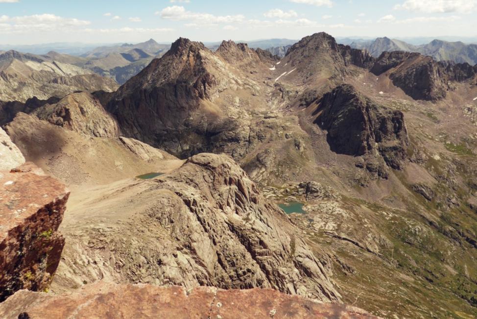
15 Mt. Eolus Twin Lakes at 12,500 After 15 minutes on the Eolus summit we headed down the same South face, looping under the cliffs, across the Catwalk and then we headed up to North Eolus. Rick C. starting up N. Eolus.


16 Going for #2 for the day. Route to N. Eolus


17 The rock on N. Eolus was very different exposed but very grippy. We got to summit from the Catwalk in 45 minutes. Approaching the summit of N. Eoius
 Rick P.")

18 Summit N. Eolus, 14, 039 at 2:15pm, 2hrs 15 minutes from the summit of Mt. Eolus (behind Rick P s head) Rick P. mastered the art of setting the auto timer on his camera which gives him 10 seconds to leap across the summit rocks and get into the summit photo, somehow avoiding catapulting right off the summit. We saw exactly zero other people climbing the entire day. Here are some summit shots from this and the prior attempt:
19


20 We made it back to camp by 5 pm, making it an even 11 hour day. The sun was still shining and we had a bladder of wine to celebrate. The next morning we headed back down the 7 miles to the train. Rick P. had wisely stashed a few beers in the Animas River at the Needleton stop, so upon return, as we waited for the train, we cooled off in the cold river sipping on our brews! Rick P., beer in hand, pretending he s not freezing There is one chance to catch the train each day as it approaches they require you to stand on the East side of the tracks and cross-wave your arms in front of your waist. Only then will he stop for a few minutes while you throw your pack in the baggage car and jump on. So for those of you who think I m totally nuts we do turn around before summiting when advisable but we also don t give up when a better weather-day shows up. Mt. Eolus is a tough mountain but not because of loose gullies and endless boulder fields rather because of lots of solid-rock climbing and exposure that adds up to a lot of fun.
Mount Daly a Most Prominent Peak via South Ridge
 Mount Daly a Most Prominent Peak via South Ridge Difficulty: Class 3 Exposure: Exposed in places along the ridge Summit Elevation: 13,305 Elevation Gain: 4100 from trailhead; 1800 from Capitol Lake camp
Quandary Peak East Ridge
 Quandary Peak East Ridge Difficulty: Class 1 / 2 June 28,2013 Exposure: Summit Elev.: 14,265 feet Trailhead Elev.: 10,850 feet Elevation Gain: 3,450 feet Roundtrip: 6.75 miles Hikers: Shan Stuart, Rick
Windom Peak. Climbers: Rick Crandall; Rick Peckham August 26, 2017
 Windom Peak Difficulty: Class 3 Exposure: Significant exposure at summit Summit Elevation: 14,082 Elevation Gain: 6000 from Needleton; 3000 from Chicago Basin camp at 11,100 Round Trip: 17 miles from Needleton;
Climbers: Rick Crandall; Rick Peckham July 29, 2016
 Wilson Peak Southwest Ridge First Try Difficulty: Class 3 Exposure: Exposed top 600 to summit Summit Elevation: 14,017 Elevation Gain: 3800 Round Trip: 10 miles Trailhead: Rock of Ages (Silver Pick) Climbers:
Mt. Massive Southwest Slopes
 Mt. Massive Southwest Slopes Difficulty: Class 2 Exposure: Summit Elevation: 14,421 feet Trailhead Elevation: 10,500 feet Elevation Gain: 4,050 feet Round-trip Length: 8.00 miles Trailhead: N. Halfmoon
Grizzly Peak A - East Ridge July 15, 2012
 Grizzly Peak A - East Ridge July 15, 2012 Difficulty: Difficult Class 2/Class 3 Upper Elevation: 13,995 feet Trailhead Elevation: 11,360 feet Elevation Gain: 3,000 feet Round-trip Length: 6.0 miles Trailhead:
Ellingwood Pt. via South Zapata Creek (non-standard route)
") Ellingwood Pt. via South Zapata Creek (non-standard route) Difficulty: Class 3 Exposure: Ellingwood Pt.: Elevation Gain: RT Length: Trailhead: 14,042 feet 4,800 feet (backpacking 2740 then 2060 starting
Ellingwood Pt. via South Zapata Creek (non-standard route) Difficulty: Class 3 Exposure: Ellingwood Pt.: Elevation Gain: RT Length: Trailhead: 14,042 feet 4,800 feet (backpacking 2740 then 2060 starting
Mt. Elbert East Ridge
 Mt. Elbert East Ridge Difficulty: Class 1 Exposure: None Summit Elev.: 14,440 feet Trailhead Elev.: 10,400 feet Elevation Gain: 4,100 feet Roundtrip Length: 8.5 miles Trailhead: South Elbert (near Twin
Mt. Sneffels (from Yankee Boy Basin) - A Cool Fourteener
 - A Cool Fourteener") Mt. Sneffels (from Yankee Boy Basin) - A Cool Fourteener Difficulty: Difficult Class 3 Exposure: Summit Elev.: 14,150 feet Trailhead: Yankee Boy Basin Climbers: Rick Crandall; Shan Stuart; Laura Welch
Mt. Sneffels (from Yankee Boy Basin) - A Cool Fourteener Difficulty: Difficult Class 3 Exposure: Summit Elev.: 14,150 feet Trailhead: Yankee Boy Basin Climbers: Rick Crandall; Shan Stuart; Laura Welch
Route #2) Mt. Massive - Southwest Slopes
 Mt. Massive - Southwest Slopes") Route #2) Mt. Massive - Southwest Slopes Difficulty: Class 2 Ski: Advanced, D6 / R2 / III Exposure: Summit Elevation: Trailhead Elevation: Elevation Gain: Round-trip Length: Trailhead: County Sheriff:
Route #2) Mt. Massive - Southwest Slopes Difficulty: Class 2 Ski: Advanced, D6 / R2 / III Exposure: Summit Elevation: Trailhead Elevation: Elevation Gain: Round-trip Length: Trailhead: County Sheriff:
Durango. Durango Whitewater Park
 High Adventure Along Colorado s Million Dollar Highway Durango If you re looking for a multi-day trip of Jaw-dropping adventure in the Colorado mountains look no further! This guide outlays 4 days through
Route Combo) Mt. Bierstadt - Bierstadt, Sawtooth, Evans
 Mt. Bierstadt - Bierstadt, Sawtooth, Evans") Climbing 14ers can be very dangerous, please read the Mountaineering Safety Page and make sure you have a map+compass and can use them effectively, without the help of electronic devices. Route Combo)
Climbing 14ers can be very dangerous, please read the Mountaineering Safety Page and make sure you have a map+compass and can use them effectively, without the help of electronic devices. Route Combo)
Route #1) Mt. of the Holy Cross - North Ridge
 Mt. of the Holy Cross - North Ridge") Climbing 14ers can be very dangerous, please read the Mountaineering Safety Page and make sure you have a map+compass and can use them effectively, without the help of electronic devices. Route #1) Mt.
Climbing 14ers can be very dangerous, please read the Mountaineering Safety Page and make sure you have a map+compass and can use them effectively, without the help of electronic devices. Route #1) Mt.
The temperature is nice at this time of year, but water is already starting to be scarce.
 In March of 2003, Scott Morrison and I went backpacking in the Grand Canyon. The temperature is nice at this time of year, but water is already starting to be scarce. Another issue with this time of year
Note: Coordinates are provided as Universal Transverse Mercator UTM Zone U21, North American Datum 1983 (NAD 83).
.") Northern Traverse Route Description The Northern Traverse (formerly the North Rim Traverse) is an unmarked and rugged backcountry hiking route. It is known be a demanding hike, because of its terrain and
Northern Traverse Route Description The Northern Traverse (formerly the North Rim Traverse) is an unmarked and rugged backcountry hiking route. It is known be a demanding hike, because of its terrain and
1. Waterfall Gully Mt Lofty. 5 Of the Best Hikes in Adelaide
 Adelaide is a beautiful city, and one of the most incredible things about Adelaide is the quality of bushwalking available on the suburban fringe. It is surrounded by the Mt Lofty Ranges, and much of the
Location: Height: Access: Distance: Elevation: Season: Difficulty: Lat/Long: Directions:
 Upper Eagle Falls Upper Eagle Falls (~20 ft.) is a short hike up from the roadside at the Eagle Falls picnic area. It is very difficult to get a parking spot here during the day, so it is recommended to
colorado trail SUMMER 2018
 DENVER, COLORADO 39.7392 N, 104.9903 W colorado trail trip overview With the most elevation of any state in the lower 48, Colorado is the place to play in the mountains. The stunning peaks and raging rivers
Weminuche Wilderness, September 2007
 Backpacking Itinerary Weminuche Wilderness, September 2007 Day Route 1 Drive to Missionary Ridge trailhead, hike to City Reservoir 2 Hike over Silver Mesa, Trimble Pass, Columbine Pass, and into Chicago
Mt. Lindsey in the Sangre de Cristos Aug 16, 2011
 Mt. Lindsey in the Sangre de Cristos Aug 16, 2011 Difficulty: Class 3 Summit Elevation: 14,042 feet Trailhead Elevation: 10,700 feet Elevation Gain: 3,500 feet but for us it was over 4000 Round-trip Length:
The Colorado Rockies
 Covered Wagon Tours presents The Colorado Rockies featuring National Parks and Historic Trains September 8 16, 2018 Book by March 8, 2018 & Save $ 250 Per Person For more information contact Covered Wagon
Oman Trek Trek the dramatic and beautiful scenery of Oman
 Oman Trek Trek the dramatic and beautiful scenery of Oman Discover Oman on this breath taking 5 day challenge. The mountain ranges and deserts of Oman offer spectacular trekking, and enables you to experience
TREK KILIMANJARO ABOUT THE CHALLENGE KILIMANJARO TREK - 11 DAY TANZANIA TREK RED 3
 TREK KILIMANJARO TANZANIA TREK RED 3 ABOUT THE CHALLENGE Climb the highest freestanding mountain in the world! Kilimanjaro is the highest mountain on the African continent at 5896m. Its snow-capped summit
Maroon Peak. Climbers: Rick Crandall; Rick Schultz and Andy Mishmash with his dog Stormy Oct 11, 2012
 Difficulty: Class 3 Exposure: Summit Elev.: 14,156 feet Trailhead Elev.: 9,590 feet Elevation Gain: 4,800 feet RT Length: 12.00 miles Trailhead: Maroon Lake Maroon Peak Climbers: Rick Crandall; Rick Schultz
OMH Trail Data / History
 Lake Sylvia Loop Ouachita National Forest (AR) This is a five-mile loop with several variations for Saturday hikes. The basic loop starts at Lake Sylvia campground and goes south to meet the Ouachita Trail
Kuruwita Erathna Trail to Sri Pada (Adam s Peak)
") Kuruwita Erathna Trail to Sri Pada (Adam s Peak) Trail Difficulty: Easy Moderate Strenuous Tough Trail Head: Adevikanda, Erathna (near entrance to mini-hydro power plant) Nearest Town: Erathna Nearest
Kuruwita Erathna Trail to Sri Pada (Adam s Peak) Trail Difficulty: Easy Moderate Strenuous Tough Trail Head: Adevikanda, Erathna (near entrance to mini-hydro power plant) Nearest Town: Erathna Nearest
Four Fourteeners in One Day
 Mt. Democrat: Summit: 14, 148 Mt. Cameron: Summit: 14,050 Mt. Lincoln: Summit: 14,286 Mt. Bross: Summit: 14,172 Four Fourteeners in One Day Trailhead: Trailhead Elev.: Total Elevation Gain: Roundtrip:
KILIMANJARO 2018 RUN & TREK February 28 March 12
 KILIMANJARO 2018 RUN & TREK February 28 March 12 Wednesday 28 Feb Depart USA to Kilimanjaro International Airport, Tanzania, Africa Thursday 01 March Arrive Kilimanjaro. Met upon arrival at the Kilimanjaro
Guide Book Excerpts. Wham Ridge 2006
 Guide Book Excerpts Wham Ridge 2006 Approach: Molus Lake / Elk Park / Vestal Creek Roach and Roach Description Take the Durango & Silverton Narrow Gauge train from either Durango or Silverton and get off
The Story of Stickeen
 r4 WT/Math/Rdg Rel '03 4/3/03 11:55 AM Page 65 Read this selection. Then answer the questions that follow it. The Story of Stickeen John Muir (1838 1914) was a well-known author and explorer who helped
18 day itinerary: ACONCAGUA Normal Route 15 day trek. T r i p I t i n e r a r y
 T r i p I t i n e r a r y HIGHLIGHTS Summit the highest mountain in South America, and the second highest of the Seven Summits Breath-taking views of the Andes Three days set aside for the summit attempt
TREK THE ROCKIES ABOUT THE CHALLENGE TREK THE ROCKIES FOR HIGHLAND HOSPICE CANADA TREK DEMANDING
 TREK THE ROCKIES CANADA TREK DEMANDING ABOUT THE CHALLENGE The Canadian Rockies are justifiably world-famous for their magnificent scenery: the combination of impressive, jagged mountains, bright turquoise
Morning Star Peak Avalanche Accident
 Morning Star Peak Avalanche Accident Saturday, December 4, 2010 Date: 2010-12-13 Submitted by: Oyvind Henningsen Everett Mountain Rescue and Mark Moore NWAC Place: Morning Star Peak, north-central WA Cascades
L U N C H C R E E K T R A I L GLACIER NATIONAL PARK
 D I R T I N M Y S H O E S L U N C H C R E E K T R A I L GLACIER NATIONAL PARK Lunch Creek "Secret" Hike This short hike on the Lunch Creek Trail will knock your socks off! It's the perfect mix of length,
Mt. Thielsen Trip Report: April 29, 2012
 Mt. Thielsen Trip Report: April 29, 2012 Outing Organizer: Geoff Hance, with Brent McGregor Elevation Gain: 3,800 feet, over warming snow, with an exposed summit block Distance: About 9 miles round trip
COLORADO TRAIN ADVENTURE
 COLORADO TRAIN ADVENTURE by Melody Hagerman at Travel the Horizon Summary Traveling by rail in Colorado is the most spectacular way to take in its unique scenery. From high above the tracks, you'll enjoy
Hiking Las Vegas.com
 Hike: Mt. Wilson via First Creek Canyon route Trailhead: First Creek marked Distance: 10 miles up and back Elevation gain: 3,400 feet Elevation of Peak: 7,070 feet Time: 7 to 9 hours (up and back) Difficulty:
 Hike date Exertion Destination/ Leader(s) Description and Contact info Rating Hike Name 7/8-12/10 S+ Extreme Pleinair Sandy Compton Contact info: 208-290-1281 or sandy@scotchmanpeak.org This hike is nearly
Draft II - Trip Report by Kurt Wibbenmeyer
 Draft II - Trip Report by Kurt Wibbenmeyer COLORADO MOUNTAIN CLUB FAIRWEATHER MOUNTAIN EXPEDITION 2010 TEAM Rich McAdams Leader Mike Butyn Wayne Herrick Gerry Roach Bill Blazek Dave Covill Jim Rickard
Trail Phasing Plan. Note: Trails in the Clear Creek Canyon area (Segments will be finalized in the future to minimize wildlife impacts
 Note: Trails in the Clear Creek Canyon area (Segments 2 5 and a future JCOS connection) will be finalized in the future to minimize wildlife impacts Trail Phasing Plan P Parking 3 Easy Trail Intermediate
HORSEBACK RIDING. All rates are subject to service charges
 HORSEBACK RIDING The Local Loop Ride - A family-friendly 45-minutes to one hour ride around Dunton s east property. Perfect for children and adults who are new to riding. Easy terrain and beautiful views.
Hike at Pico Blanco Labor Day Weekend!
 Hike at Pico Blanco Labor Day Weekend! The Pico Blanco Hymn Here among the trees majestic Pleasures you will find On the trails of Pico Blanco With your friends and mine Trail the Eagle ever onward This
Adventures in the Rockies. 6 Days
 Adventures in the Rockies 6 Days Adventures in the Rockies On this action-filled adventure, experience two different sides to the Rockies on the western side, discover hidden gems that few visitors get
UTAH S NATIONAL PARK TOUR
 UTAH S NATIONAL PARK TOUR DAY 1 Each client needs to check in any time at the fabulous Aria Hotel located in the heart of Las Vegas. We will meet at 6pm for a one hour orientation explaining the schedule
Section 7: Pick Up Where You Left Off! S-Tree Road over the Todd Road
 2018 TRACE NOTES Helpful information for your adventure on Section 7 of the Hiker Challenge. Start Point S-Tree Rd. End Point Intersection Todd Rd. / Hale Ridge Rd. WEATHER DECISION Weather Alert!!!! Potential
KUSHILAND Expeditions & Tour Safaris Ltd
 KILIMANJARO TREK MACHAME ROUTE TOUR CODE KMC 02 7 DAYS MACHAME ROUTE Kilimanjaro s Machame Route, often referred to as the Whiskey route, is more scenic and is longer than Marangu. The minimum duration
Jeff at Bar 10, trikes and planes in background. My trike. Living room, dining room Bar 10 Lodge
 Monday, October 23, 2017 Cobra flight #609, PIC #622, 4 landings Zion Canyon, Bruce Canyon, Escalante, Stevens Arch, San Juan Goosenecks, Bluff Dirt Road I got a great night sleep, and woke up a little
Climbing Oak and Brushy Top Mountains
 Climbing Oak and Brushy Top Mountains Story and photographs by Vann Helms www.blueridgeimpressions.org Brushy Top Mountain- February 2, 2014 Brushy top summit After a January of record breaking cold weather,
Mark Warther $2695 PP Dbl (plus air) Warther Tours can handle all air arrangements
 Warther Tours can handle all air arrangements") Warther Tours Presents: Trains & Parks of Colorado August 3rd - 11th, 2019 With train expert and Colorado enthusiast, Mark Warther as featured in Home & Away Magazine Travel Colorado with train expert
Warther Tours Presents: Trains & Parks of Colorado August 3rd - 11th, 2019 With train expert and Colorado enthusiast, Mark Warther as featured in Home & Away Magazine Travel Colorado with train expert
Three Sisters Wilderness Oct. 2009
 Three Sisters Wilderness Oct. 2009 I was in Bend, OR and had the whole day to travel back to Boise so I decided to take a hike to the popular Green Lakes and summit the South Sister in Three Sisters Wilderness.
GOING CAMPING HAL AMES
 GOING CAMPING HAL AMES Robert did not like camping. He liked his house, his bed and his shower. When he was eight years old his father had taken him on their first, and last, camping trip together. It
Glacier National Park, MT
 Glacier National Park, MT July 28 Aug. 1, 2010 We decided to go to Glacier National Park for our family vacation this year. We had a great time seeing beautiful scenery and a variety of wildlife which
Itinerary Overview: What you will be doing Maroon Bells Alpine Backpacking 22 days
 Itinerary Overview: What you will be doing Maroon Bells Alpine Backpacking 22 days 0BCourse Description Welcome, you re in for an experience of a lifetime! Imagine hiking through rolling forests, sharing
Snowmass Mountain. Climbers: Brett Crandall; Rick Crandall; Rick Peckham August 11, 2014
 Snowmass Mountain Difficulty: Class 3 & 4 Exposure: Summit Elev.: 14,092 feet Trailhead Elev.: 8,400 feet Elevation Gain: 5,800 total; 3200 from Snowmass Lake RT Length: 22.00 miles total; 5 miles from
Itinerary Overview. Sangre de Cristo Alpine Backpacking 22 days Ages Course Description
 Itinerary Overview Sangre de Cristo Alpine Backpacking 22 days Ages 16-18 Course Description Welcome, you re in for an experience of a lifetime! Imagine hiking through rolling forests, sharing alpine meadows
USA. Rocky Mountains and Grand Canyon Trekking
 USA Rocky Mountains and Grand Canyon Trekking Itinerary USA Rocky Mountains and Grand Canyon Trekking 15 Days 14 Nights Jackson - Grand Teton Yellowstone Colorado Rocky Mountains Aspen Maroon Bells Durango
Etna winter expedition 1
 Etna winter expedition Etna, still active volcano. I ve been always tempted to climb it. I found a cheap flight ticket to Catania in February and I told myself why not in the winter! Two adventurous friends
CIEC 9 PEAKS AWARD SUPPLEMENT POSSIBLE ROUTES FOR THE 9 PEAKS AWARD TRIP
 CIEC 9 PEAKS AWARD SUPPLEMENT POSSIBLE ROUTES FOR THE 9 PEAKS AWARD TRIP As you plan your trip, be aware of 3 regulations in this wilderness: 1. Camp only in designated campsites. 2. No campfires allowed.
Itinerary Overview. Continental Divide Alpine Backpacking 22 days Ages Course Description
 Itinerary Overview Continental Divide Alpine Backpacking 22 days Ages 16-18 Course Description Welcome, you re in for an experience of a lifetime! Imagine hiking through rolling forests, sharing alpine
World. Drive Holidays. Guided Seattle to Denver 16 Days / 15 Nights. Available Summer, Autumn. Day 1 - Seattle Arrival
 Canada & Yellowstone Guided Motorcycle Tour Guided Seattle to Denver 16 Days / 15 Nights Available Summer, Autumn This once in a lifetime journey takes you from the emerald waters of Seattle, through the
Self-Guided Walk Langdale Pikes. Start & Finish: NT car park (free to members) at Sticklebarn - on the right just beyond the New Dungeon Ghyll hotel.
 at Sticklebarn - on the right just beyond the New Dungeon Ghyll hotel.") Self-Guided Walk Langdale Pikes Key Information These mountains form a collection of spires and cliffs on the north side of Langdale. This walk visits four of the main tops Pavey Ark, Harrison Stickle,
Self-Guided Walk Langdale Pikes Key Information These mountains form a collection of spires and cliffs on the north side of Langdale. This walk visits four of the main tops Pavey Ark, Harrison Stickle,
ADVENTURE GRANDPA BICYCLE TOUR OF COLORADO
 ADVENTURE GRANDPA BICYCLE TOUR OF COLORADO PREPARED FOR BRANDT AND CAMDEN (MY GRANDSONS) June 22-July 1, 2006 June 22 Brent Fisher and I left Houston about 6AM and headed for Wichita Falls where we would
THE HISTORIC TRAINS OF COLORADO With Five Historic Rail Excursions September 13-20, 2018
 THE HISTORIC TRAINS OF COLORADO With Five Historic Rail Excursions September 13-20, 2018 8 DAYS TOUR HIGHLIGHTS & INCLUSIONS Roundtrip Airfare Deluxe Motorcoach Transportation 7 Nights Quality Accommodations
Friday October 3. Lower Javelina Trail - Level D. about 3 miles, less than 500. Hike Contact: Joel Tormoen
 Friday October 3 Lower Javelina Trail - Level D. about 3 miles, less than 500 Hike Contact: Joel Tormoen joeltormoen@gmail.com Depart WB trailhead 8:00 am - return before 11:00 am This quite easy hike
Trains & Parks of Colorado June 23 - July 1, 2018
 Warther Tours Presents: Trains & Parks of Colorado June 23 - July 1, 2018 Join Mark Warther on this personally designed adventure through majestic Colorado, the premier destination for rail excursions.
Prince Regent National Park
 Prince Regent National Park 23 rd June- 14 th July 2019 Garimbu Creek, Moran and Roe River Area Notes written by Cassie Newnes This area has something for everyone, magnificent scenery, stunning waterfalls,
PERUVIAN ANDES ADVENTURES. EXPEDITION Climbing Alpamayo & Huascaran. PEAKS: Maparaju 5350m Alpamayo 5947m Huascaran Sur 6768m
 PERUVIAN ANDES ADVENTURES EXPEDITION Climbing Alpamayo & Huascaran PEAKS: Maparaju 5350m Alpamayo 5947m Huascaran Sur 6768m 23 days Huaraz to Huaraz Grade: Technical, physically demanding This is a comprehensive
The Cleo s Bath North Side Hike
 The Cleo s Bath North Side Hike This hike is a cross-country hike from Pinecrest Lake to the north side of Cleo s Bath. It is quieter and much less crowded than the normal route, which goes up the south
NATIONAL ATV / UTV JAMBOREE RIDES
 NATIONAL ATV / UTV JAMBOREE RIDES Note: Rides range from Beginner to Advanced and will last from 2 to 3 hours or an entire day of riding. 1. DESERT RIDE (CLEAR LAKE BIRD REFUGE & LACE CURTAINS/LAVA TUBES)
Trains of the Colorado Rockies
 West Coast Rail Tours presents Trains of the Colorado Rockies August 8 16, 2014 $ 100 For more information contact Jennifer Mitchell West Coast Rail Tours (604)524-1011 tours@wcra.org 9 Days 12 Meals:
Trail Beginning Elevation: 7553 ft The Poison Creek Trailhead is located at the end of National Forest Road 646E (NF-646E).
.") West Mountain Trails Poison Creek Trail #134 Length: 2.9 miles (4.7 km) Difficulty Horseback: A good trail for the first time west mountain rider, some steep sections Hiking: Most Difficult USGS Maps:
West Mountain Trails Poison Creek Trail #134 Length: 2.9 miles (4.7 km) Difficulty Horseback: A good trail for the first time west mountain rider, some steep sections Hiking: Most Difficult USGS Maps:
21 Aug. 2004, 9:45am, at the Paradise trailhead. The day before the climb, we all took part in a one-day climbing school to refresh our skills in
 21 Aug. 2004, 9:45am, at the Paradise trailhead. The day before the climb, we all took part in a one-day climbing school to refresh our skills in walking with crampons on snow and ice, and in arresting
Trains of the Colorado Rockies
 Senior Circle - Women & Children's Hospital presents Trains of the Colorado Rockies August 16 24, 2014 BOOK NOW & SAVE $ 100 Per Person For more information contact James Halphen Globetrek Travel 337-477-0835
Nanda Devi East Base Trek Photo Log - October 2016
 Nanda Devi East Base Trek Photo Log - October 2016 As one drives through Kumaon the most noticeable aspect is how different the terrain is as compared to Garhwal. The foothills are a lot more gentle in
YOSEMITE ON HORSEBACK: THREE RIDES ALONG TIOGA ROAD Cindy Casey White Wolf Area, May Lake Loop, Ragged Peak Loop
 YOSEMITE ON HORSEBACK: THREE RIDES ALONG TIOGA ROAD Cindy Casey White Wolf Area, May Lake Loop, Ragged Peak Loop The high country along Tioga Road presents us with some of the most dramatic scenery in
Kit Carson-Challenger Ridge Trail Project Annual Performance Report-2014 October 22, 2014
 1 Kit Carson-Challenger Ridge Trail Project Annual Performance Report-2014 October 22, 2014 Willow Lake and Kit Carson Peak 2 SUMMARY The Rocky Mountain Field Institute began Phase 1 of a multi-phase,
Itinerary Overview. Maroon Bells Mountaineering 22-days. Course Description
 Itinerary Overview Maroon Bells Mountaineering 22-days Course Description Welcome, you re in for an experience of a lifetime! Imagine hiking through rolling forests, sharing alpine meadows with mountain
Itinerary Overview. Colorado San Juan Mountaineering 15-days
 Itinerary Overview Colorado San Juan Mountaineering 15-days Course Description Welcome, you re in for an experience of a lifetime! Imagine hiking through rolling forests, sharing alpine meadows with mountain
Trip Report: Backpack to East Boulder Lake in California Trinity Alps, July 7-9, 2016
 Trip Report: Backpack to East Boulder Lake in California Trinity Alps, July 7-9, 2016 Trekkers: Richard Hales, Aleece Townsend, Carol Mockridge, Rosalie Rybka, Elisabeth Zinser Day 1: Richard and Aleece
CIRCLE THE AMERICAN WEST
 CIRCLE THE AMERICAN WEST 15 Day Tour from Denver to Denver May 31- June 14, 2019 Mother Nature has loaded the West with stunning scenery, and on this National Parks tour, you ll witness some of natures
Itinerary Overview. Sawatch Range Mountaineering Ages days
 Itinerary Overview Sawatch Range Mountaineering Ages 14-16 22 days Course Description Welcome, you re in for an experience of a lifetime! Imagine hiking through rolling forests, sharing alpine meadows
Mount Kilimanjaro Climbing via Marangu Route 6 day-itinerary
 Mount Kilimanjaro Climbing via Marangu Route 6 day-itinerary (For the 5-day route, simply exclude the additional acclimatisation day at Horombo hut - day 3 on the itinerary below.) Total hiking distance:
Little Grand Canyon near Pomona, Illinois
 Little Grand Canyon near Pomona, Illinois Below: View of the trail and the terrain created using the Map My Hike app Below: Summary of the hike created using the Map My Hike app Presented by: Jennifer
Machame 7 Days 6 Nights
 Machame 7 Days 6 Nights If Marangu is the Coca Cola route, then the Machame Route is the Whiskey route. It is the second most popular and one of the most scenic routes on the mountain. All climbers sleep
CLASSIC COLS OF THE ALPS
 FRANCE, SWITZERLAND CYCLE RED 1 ABOUT THE CHALLENGE KING OF THE MOUNTAINS CYCLES This short but intensely demanding cycle challenge takes us through the heart of the French Alps, tackling a series of classic
VCC WINTER Association Directives
 VCC WINTER Association Directives Tuesday, July 24, 2018 Q1: Which association are you a member of? Answered: 46 Skipped: 0 8 14 21 3 Q2: Which best describes your primary business? Answered: 46 Skipped:
Measurements, Weight and Pictures Please read all of this, will take you 5 minutes. : )
") Measurements, Weight and Pictures Please read all of this, will take you 5 minutes. : ) Below is the information for how you submit your measurements to track your progress and your pictures for the 6-week
Measurements, Weight and Pictures Please read all of this, will take you 5 minutes. : ) Below is the information for how you submit your measurements to track your progress and your pictures for the 6-week
Don Boyles personal Account of record setting jump.
 Don Boyles personal Account of record setting jump. About The Author Sept. 7, 1970 The Royal Gorge Parachute Jump Mr. Boyles is married and the father of four children, John 10, Jerry 8, Donna 5, and Sheila
APPENDIX D: SUSTAINABLE TRAIL DESIGN. APPENDICES Town of Chili Parks and Recreation Master Plan Update
 APPENDIX D: SUSTAINABLE TRAIL DESIGN APPENDICES Town of Chili Parks and Recreation Master Plan Update Sustainable Trail Construction Sustainable trails are defined by the US Forest Service as trails having
Charnley Explorer June 24 - July 15, 2018 Bachsten Creek and the Charnley River. Second draft: 14 November 2017
 Charnley Explorer June 24 - July 15, 2018 Bachsten Creek and the Charnley River. Second draft: 14 November 2017 The best part of the original section one is now part of out Gibb Road Gorges trip. The dates
Kirigalpoththa Nature Trail Horton Plains National Park
 Kirigalpoththa Nature Trail Horton Plains National Park Trail Difficulty: Easy Moderate Strenuous Tough Trail Head: Horton Plains Visitor Centre Nearest Town: Pattipola Nearest City: Nanu-Oya Access to
! Kilimanjaro Expedition
 ! Kilimanjaro Expedition Tanzania 2016 Climb Only: $4,350 (land costs) Feb 4-12; June 12-20; July 10-18; Aug 6-14; Sept 11-19; Dec 4-12 2016 Climb & Safari: $5,850 (land costs) Feb 4-15; June 12-23; July
Letter Assessment. (date) Dear, In 1864, Then in 1866, In 1867, As it happened in 1868, Then in 1877, The bust came in.
 Dear, In 1864, Then in 1866, In 1867, As it happened in 1868, Then in 1877, The bust came in.") Letter Assessment (date) Dear, In 1864, Then in 1866, In 1867, As it happened in 1868, Then in 1877, The bust came in. Your friend, The Birth of a City and Railroad in the Rocky Mountains Modified for
Letter Assessment (date) Dear, In 1864, Then in 1866, In 1867, As it happened in 1868, Then in 1877, The bust came in. Your friend, The Birth of a City and Railroad in the Rocky Mountains Modified for
GOLDEN EARS PROVINCIAL PARK
 GOLDEN EARS PROVINCIAL PARK Trail Information as of October 10 th 2015 Do not underestimate the mountainous wilderness of Golden Ears Provincial Park. The combination of rugged terrain and rapidly changing
Chapter 1 You re under arrest!
 Chapter 1 You re under arrest! My life is hell! Ryan thought. Most days weren t good, but today was worse than usual. He walked out of the corner shop with a packet of cigarettes. Sixteen-year-old Ryan
Twin Shaw Lakes. The girls at Upper Shaw Lake
 Twin Shaw Lakes 11 th Annual Daddy-daughter Adventure The girls at Upper Shaw Lake On Aug. 14-15, 2017 we (Brynn, Hailey, Kylie & Madilyn) decided to hike into Twin Shaw Lakes near McCall, ID. This was
Tips for flying with a vent-dependent, very low-tone kiddo
 Following the 2013 MTM-CNM Family Conference, Krista Hanson and Burke Stansbury wrote the following reflection for us on flying with their son Lucas to share their experience and helpful suggestions about
OHENRY SECTIONAL TENT INSTRUCTIONS
 INSTRUCTIONS Please follow these instructions carefully so your new Ohenry tent will be installed correctly. The pictures are based on installing a Traditional Pole Type Tent, but also apply to High Peak
Mind Hike 2019 Islands or Highlands
 I made new, life-long friends and smashed what I thought were my own personal limits. Mind Hike 2019 Islands or Highlands Registration fee: 95 Minimum sponsorship 690 www.mind.org.uk/mindhike Reg. Charity
Itinerary Overview and Travel Information: 15-Day Alaska Alpine Backpacking Course for Adults
 Itinerary Overview and Travel Information: 15-Day Alaska Alpine Backpacking Course for Adults Course Description Welcome, you re in for the experience of a lifetime! Imagine hiking through rolling forests,