FROM JUTA TO ROSHKA via Chaukhi pass
|
|
|
- Cecilia Quinn
- 5 years ago
- Views:
Transcription
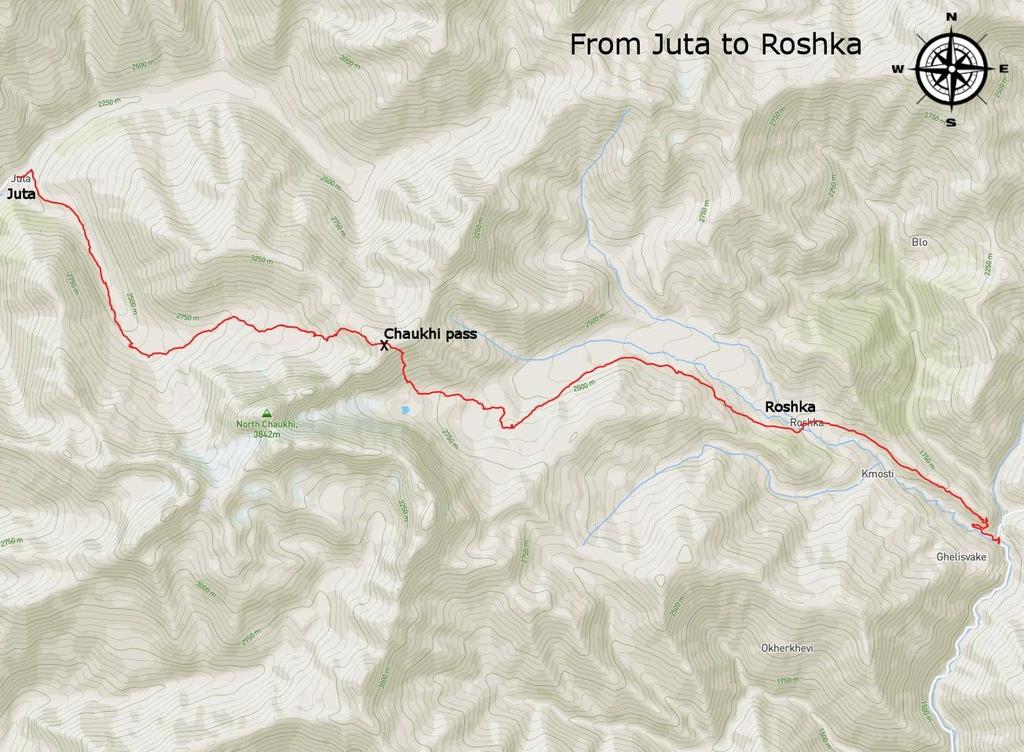
1 FROM JUTA TO ROSHKA via Chaukhi pass Duration: 1-2 days The hike can take one or two days, depending on how you plan it. I will focus on the 1-day version of the trek which takes 8-9 hours and starts in Juta. Starting in Roshka, it s almost impossible to finish this hike in a day. Difficulty: Moderate It's a long hike, but you will be gaining elevation quite slowly (from Juta side) and the path is well-trodden. From Roshka direction, I would rate it as Hard. Accommodation: If you go for 1-day version, you can sleep in the guesthouse in Roshka. Otherwise, you will need a tent. Which way to hike: I recommend Juta - Roshka direction; the trek is less strenuous this way as Juta lies higher by almost 400 meters. You also ascend more slowly, walking up the long valley. There is only one steeper section before you reach the pass. If you want to climb to the pass from Roshka side, prepare yourself for the arduous ascent from Abudelauri lakes. When to go: Chaukhi pass is one of the highest and steepest "tourist" passes in Georgia and therefore remains inaccessible longer than the others. It becomes passable in the second half of June (the exact date differs year from a year) and even then you will have to tackle the substantial amount of the leftover snow. Overall, the best period for this hike is from the beginning of July till the end of September. If you are lucky with the weather, you can have a nice hike even in first weeks of October. Later usually come first severe snowfalls which block the pass till the next season.
2 How to get to Juta: There is no public transport, so probably the best option for solo hikers and couples is the daily bus arranged by Mountain Freaks agency. It depart at 8:30 from their office (colorful building little south of the main square in Kazbegi) and return at 17:00. Price of the return ticket is 25 GEL and the bus departs when there are three passengers. Larger groups may prefer a private taxi - ask the owner of your guesthouse or people at the main square. Price for the one-way trip is GEL and the ride takes 45 minutes. Finally, if you want to walk by foot, from Kazbegi its almost 4 hours of walking (17 km) How to leave Roshka: Leaving Roshka may be tricky as there is no public transport - you will have to walk around a village and ask for a driver. It took us half of an hour until some villager called a guy who drove us to Barisakho. It did cost us 60 GEL, but it was the only option as we wanted to catch a bus to Tbilisi on the next day. But if you have more time, I recommend walking all the way to Barisakho. Also this route is recorded in a gpx log. In Barisakho, there is daily marshrutka departing to Tbilisi at 9 am. If you want to continue north to Shatili, on Wednesdays and Saturdays, there is a marshrutka from Tbilisi passing the village before noon. Only other options are paying for a ride or hitchhiking. If you need to return to Juta and don't want to use the same route, you can get there through the Arkhoti valley. Prepared by
3 Description of the route The driver will drop you at the beginning of Juta by a huge hiking map of the area, the courtesy of Polish trekkers - the route is marked by blue marks. Cross the bridge and turn right onto a small track, which climbs uphill. After some 15 minutes, you will come to Zeta camp. The trail from here continues to the newly built 5 seasons camp / restaurant. From here, it mostly traverses the eastern side of the valley, crosses the river (no bridge, you will have to ford it) and heads directly towards striking green/yellow tent. After a closer look, you see it s another pub and lies on the bank of small, artificially created lake - things really changed up there in the last few years. Keep walking, pass several more or less dirty campground. Valley here bends to the east, you will have to cross several smaller streams on your way. At the end of the valley, the path turns to the south and there is a steep climb - then there are another 20 minutes of walk to the actual Chaukhi pass. Chaukhi pass is a great viewing point and also a place to have a lunch. Walk from Juta takes over 4 hours so it should be around noon when you get there. After the break, you need to descend into the valley. It's quite pleasant as the terrain is loose, so you are descending and sliding at the same time. But I would hate having to climb this way edit: Climb from Roshka side is every inch as tricky as I expected. Not only it is very steep, but the trail is often made of very soft rubble, which slides down at every step. So you have to climb at the edges of the trail, where the terrain is a bit more solid. Once you are done with the steepest descent, the terrain becomes harder to navigate. The path first follows small depression, then sharply turns to the right and leads you towards Abudelauri lakes. There are three of them, but we found only 2 - white one is little more south from the marked path. All three lakes are visible from the Chaukhi pass. Continue down the valley. To the left, you will see so-called "Roshka stones" - wandering boulders, that have been brought here by glaciers from Chaukhi massif during the last Ice Age. Also, you see an ugly road (I know, I know, it s important) being built in the direction of Arkhoti valley. The route here is clearly visible, but it's quite a walk - you will need another 2 or 3 hours to get to the Roshka village.
4 The 2-day alternative of the trek Beginning as a one-day variant, but you don't have to make it to Roshka. Break a camp near Abudelauri lakes, there is one beautiful spot above green one, between the rocks. On the next day walk to Roshka, cross the bridge and follow the tourist pointer - trail follows the dirt road to the right, past the small barricade. Descent a bit into the hogweed jungle below the ancient toilet, trail here turns into the footpath again. You traverse the valley on a nice rocky trail and end up in another field of hogweeds. Ahead, you see a small hill with trees on top. Circumvent it from the right side - trail here may be overgrown but should appear again at its other side. From there, it s straightforward. Follow the trail. First, it's descending slowly, then a steep serpentine finally takes you down to the river. There is a bridge - some wooden planks look a bit suspicious, so be careful here. You will emerge on the main road to Shatili close to the bridge over Aragvi river. Walk from Roshka to the main road is 5 km long and should take no more than 1,5 hours.
5
6
7
Ala-Kul trekking guide.
 Ala-Kul trekking guide. The marshrutka 101 brings you to the entrance of the park. For 400 KGS, a taxi will stop between the entrance and the broken bridge, saving at least 1 hour of walk. Download me
Route #1) Mt. of the Holy Cross - North Ridge
 Mt. of the Holy Cross - North Ridge") Climbing 14ers can be very dangerous, please read the Mountaineering Safety Page and make sure you have a map+compass and can use them effectively, without the help of electronic devices. Route #1) Mt.
Climbing 14ers can be very dangerous, please read the Mountaineering Safety Page and make sure you have a map+compass and can use them effectively, without the help of electronic devices. Route #1) Mt.
Access. Road from start point (W01) to campground (W56) Water Taxi Pick-up (W03)
 to campground (W56) Water Taxi Pick-up (W03)") WAIKAREMOANA GREAT WALK 260 Series Map: W18 Waikaremoana NZ Grid GPS: Geodetic Datum 1949 Topo50 Maps: BG39 Ruatahuna & BG40 Waikaremoana Gaps: on WGS84 Topo250 Map: Sheet 10 To get to START: Exit Taupo
WAIKAREMOANA GREAT WALK 260 Series Map: W18 Waikaremoana NZ Grid GPS: Geodetic Datum 1949 Topo50 Maps: BG39 Ruatahuna & BG40 Waikaremoana Gaps: on WGS84 Topo250 Map: Sheet 10 To get to START: Exit Taupo
Route #2) Mt. Massive - Southwest Slopes
 Mt. Massive - Southwest Slopes") Route #2) Mt. Massive - Southwest Slopes Difficulty: Class 2 Ski: Advanced, D6 / R2 / III Exposure: Summit Elevation: Trailhead Elevation: Elevation Gain: Round-trip Length: Trailhead: County Sheriff:
Route #2) Mt. Massive - Southwest Slopes Difficulty: Class 2 Ski: Advanced, D6 / R2 / III Exposure: Summit Elevation: Trailhead Elevation: Elevation Gain: Round-trip Length: Trailhead: County Sheriff:
KUSHILAND Expeditions & Tour Safaris Ltd
 KILIMANJARO TREK MACHAME ROUTE TOUR CODE KMC 02 7 DAYS MACHAME ROUTE Kilimanjaro s Machame Route, often referred to as the Whiskey route, is more scenic and is longer than Marangu. The minimum duration
Location: Height: Access: Distance: Elevation: Season: Difficulty: Lat/Long: Directions:
 Upper Eagle Falls Upper Eagle Falls (~20 ft.) is a short hike up from the roadside at the Eagle Falls picnic area. It is very difficult to get a parking spot here during the day, so it is recommended to
Grizzly Peak A - East Ridge July 15, 2012
 Grizzly Peak A - East Ridge July 15, 2012 Difficulty: Difficult Class 2/Class 3 Upper Elevation: 13,995 feet Trailhead Elevation: 11,360 feet Elevation Gain: 3,000 feet Round-trip Length: 6.0 miles Trailhead:
TREK KILIMANJARO ABOUT THE CHALLENGE KILIMANJARO TREK - 11 DAY TANZANIA TREK RED 3
 TREK KILIMANJARO TANZANIA TREK RED 3 ABOUT THE CHALLENGE Climb the highest freestanding mountain in the world! Kilimanjaro is the highest mountain on the African continent at 5896m. Its snow-capped summit
TREK THE ROCKIES ABOUT THE CHALLENGE TREK THE ROCKIES FOR HIGHLAND HOSPICE CANADA TREK DEMANDING
 TREK THE ROCKIES CANADA TREK DEMANDING ABOUT THE CHALLENGE The Canadian Rockies are justifiably world-famous for their magnificent scenery: the combination of impressive, jagged mountains, bright turquoise
HB/VS-078 Üssers Barrhorn
 HB/VS-078 Üssers Barrhorn Paul HB9DST, August 23, 2015 Summary: This was a HB9SOTA club project, an activation of the highest summit in Europe you can hike up without ropes or other equipment. The headline
MT KILIMANJARO TREK- LEMOSHO ROUTE
 #Trekking MT KILIMANJARO TREK- LEMOSHO ROUTE 10 Days 9 Nights Overview Take the challenging and less-travelled Lemosho route up to the highest peak in Africa, considered by many to be the most beautiful
Trail Phasing Plan. Note: Trails in the Clear Creek Canyon area (Segments will be finalized in the future to minimize wildlife impacts
 Note: Trails in the Clear Creek Canyon area (Segments 2 5 and a future JCOS connection) will be finalized in the future to minimize wildlife impacts Trail Phasing Plan P Parking 3 Easy Trail Intermediate
(west) onto Charleston Boulevard. Drive 16 miles on Charleston and turn right into Red Rock
 onto Charleston Boulevard. Drive 16 miles on Charleston and turn right into Red Rock") Hike: North Peak and Ice Box Overlook up and back Trailhead: 2.5 miles up the Rocky Gap Road not mark Distance: 5 miles round trip Elevation gain: 2,694 feet Elevation Peak: 7,094 feet Time: 3 to 5 hours
Hike: North Peak and Ice Box Overlook up and back Trailhead: 2.5 miles up the Rocky Gap Road not mark Distance: 5 miles round trip Elevation gain: 2,694 feet Elevation Peak: 7,094 feet Time: 3 to 5 hours
Trip Report: Backpack to East Boulder Lake in California Trinity Alps, July 7-9, 2016
 Trip Report: Backpack to East Boulder Lake in California Trinity Alps, July 7-9, 2016 Trekkers: Richard Hales, Aleece Townsend, Carol Mockridge, Rosalie Rybka, Elisabeth Zinser Day 1: Richard and Aleece
Mount Kilimanjaro Climbing via Rongai Route 8 day-itinerary
 Mount Kilimanjaro Climbing via Rongai Route 8 day-itinerary Total hiking distance: Approximately 70 kms The Rongai route ascends Kilimanjaro from the north-eastern side of the mountain, along the border
HIKING IN THE CANADIAN ROCKIES
 HIKING IN THE CANADIAN ROCKIES Distance Time Elevation y MORAINE LAKE TRAILS THE ROCKPILE 0.8 km (0.5 mi) 20 min 30 m (98 ft) Located adjacent to the Lodge, the short interpretive trail up the Rock Pile
PERUVIAN ANDES ADVENTURES. ARTESONRAJU CLIMB 6025m (19767 ft) Grade: D+ to TD/ Technical. Routes: The two routes to climb Artesonraju are;
 Grade: D+ to TD/ Technical. Routes: The two routes to climb Artesonraju are;") PERUVIAN ANDES ADVENTURES ARTESONRAJU CLIMB 6025m (19767 ft) Grade: D+ to TD/ Technical Routes: The two routes to climb Artesonraju are; *Via the Paron Valley South East Ridge 5 days (option for 6 with
PERUVIAN ANDES ADVENTURES ARTESONRAJU CLIMB 6025m (19767 ft) Grade: D+ to TD/ Technical Routes: The two routes to climb Artesonraju are; *Via the Paron Valley South East Ridge 5 days (option for 6 with
6 DAYS MACHAME ROUTES ON KILIMANJARO
 6 DAYS MACHAME ROUTES ON KILIMANJARO Day 1: Moshi Machame camp In the morning, we depart from our base hotel at approximately 8:00 AM for the Machame village where you begin the trek. From the park entrance
Self-Guided Walk Langdale Pikes. Start & Finish: NT car park (free to members) at Sticklebarn - on the right just beyond the New Dungeon Ghyll hotel.
 at Sticklebarn - on the right just beyond the New Dungeon Ghyll hotel.") Self-Guided Walk Langdale Pikes Key Information These mountains form a collection of spires and cliffs on the north side of Langdale. This walk visits four of the main tops Pavey Ark, Harrison Stickle,
Self-Guided Walk Langdale Pikes Key Information These mountains form a collection of spires and cliffs on the north side of Langdale. This walk visits four of the main tops Pavey Ark, Harrison Stickle,
KILIMANJARO 2018 RUN & TREK February 28 March 12
 KILIMANJARO 2018 RUN & TREK February 28 March 12 Wednesday 28 Feb Depart USA to Kilimanjaro International Airport, Tanzania, Africa Thursday 01 March Arrive Kilimanjaro. Met upon arrival at the Kilimanjaro
Trek2Kili P.O. Box 2112 Moshi TZ Whatsapp
 Trek2Kili P.O. Box 2112 Moshi TZ Whatsapp +255 673 360 trek2kili@gmail.com MT. KILIMANJARO SHIRA 8 DAY 7 NIGHT TREK Very similar to Lemosho route, however it starts at 3,600 meters and is therefore not
Mt. Thielsen Trip Report: April 29, 2012
 Mt. Thielsen Trip Report: April 29, 2012 Outing Organizer: Geoff Hance, with Brent McGregor Elevation Gain: 3,800 feet, over warming snow, with an exposed summit block Distance: About 9 miles round trip
CIEC 9 PEAKS AWARD SUPPLEMENT POSSIBLE ROUTES FOR THE 9 PEAKS AWARD TRIP
 CIEC 9 PEAKS AWARD SUPPLEMENT POSSIBLE ROUTES FOR THE 9 PEAKS AWARD TRIP As you plan your trip, be aware of 3 regulations in this wilderness: 1. Camp only in designated campsites. 2. No campfires allowed.
Little Grand Canyon near Pomona, Illinois
 Little Grand Canyon near Pomona, Illinois Below: View of the trail and the terrain created using the Map My Hike app Below: Summary of the hike created using the Map My Hike app Presented by: Jennifer
Machame 7 Days 6 Nights
 Machame 7 Days 6 Nights If Marangu is the Coca Cola route, then the Machame Route is the Whiskey route. It is the second most popular and one of the most scenic routes on the mountain. All climbers sleep
PERUVIAN ANDES ADVENTURES. EXPEDITION Climbing Alpamayo & Huascaran. PEAKS: Maparaju 5350m Alpamayo 5947m Huascaran Sur 6768m
 PERUVIAN ANDES ADVENTURES EXPEDITION Climbing Alpamayo & Huascaran PEAKS: Maparaju 5350m Alpamayo 5947m Huascaran Sur 6768m 23 days Huaraz to Huaraz Grade: Technical, physically demanding This is a comprehensive
The temperature is nice at this time of year, but water is already starting to be scarce.
 In March of 2003, Scott Morrison and I went backpacking in the Grand Canyon. The temperature is nice at this time of year, but water is already starting to be scarce. Another issue with this time of year
Travel deals available for adventures and backpackers.
 Mount Kilimanjaro is an overall winner of African leading Tourist Attraction in 2017. Mount Kilimanjaro beautiful Geographical features to be seen when climbing to summit are Coffee farms, nature forest,
Tiger Mountain State Forest:
 98 60 hikes within 60 miles: SEATTLE 20 Tiger Mountain State Forest: West Tiger Mountain Three Loop i KEY AT-A-GLANCE INFORMATION Length: 5.1 miles round-trip Configuration: Loop Difficulty: Moderate difficult
The height of Machu is 6630m on the Swiss map, 6612m on the Russian map and 6603m on Google Earth.
 Hispar Expedition 2017 Expedition Final Report MEF reference: 17-42 Country and region visited: Pakistan, Hunza Valley, Karakoram. Objective To make the first ascent of Machu (6630m) by the southwest and
Griffith Park Trail Run Trail Guide Click for
 The Griffith Park Trail Run by Hike- LosAngeles.com Griffith Park Trail Run Trail Guide Click for downloadable cell phone guide and map from EveryTrail. DISTANCE: 4.55 Miles ELEVATION: 1280' ELEVATION
APPENDIX D: SUSTAINABLE TRAIL DESIGN. APPENDICES Town of Chili Parks and Recreation Master Plan Update
 APPENDIX D: SUSTAINABLE TRAIL DESIGN APPENDICES Town of Chili Parks and Recreation Master Plan Update Sustainable Trail Construction Sustainable trails are defined by the US Forest Service as trails having
Trek2Kili P.O. Box 2112 Moshi TZ Whatsapp
 Trek2Kili P.O. Box 2112 Moshi TZ Whatsapp +255 673 360 trek2kili@gmail.com MT. KILIMANJARO MACHAME 7 DAY 6 NIGHT TREK Known as the Whisky Route, this is one of the most scenic and therefore popular routes
Charnley Explorer June 24 - July 15, 2018 Bachsten Creek and the Charnley River. Second draft: 14 November 2017
 Charnley Explorer June 24 - July 15, 2018 Bachsten Creek and the Charnley River. Second draft: 14 November 2017 The best part of the original section one is now part of out Gibb Road Gorges trip. The dates
Trekking at Peuma Hue
 Trekking at Peuma Hue Peuma Hue is a paradise for those who love hiking and trekking. A large variety of trails cross pristine forest, ancient rocks and stunning waterfalls with beautiful views over the
Victoria Falls Lookout to Blue Gum Forest
 Victoria Falls Lookout to Blue Gum Forest 8 hrs Experienced only 13.8 km One way 5 112m This long day-walk follows a remote track down from Victoria Falls lookout, passing the waterfall, and into the Grose
18 day itinerary: ACONCAGUA Normal Route 15 day trek. T r i p I t i n e r a r y
 T r i p I t i n e r a r y HIGHLIGHTS Summit the highest mountain in South America, and the second highest of the Seven Summits Breath-taking views of the Andes Three days set aside for the summit attempt
Camp Jack Wright PERMANENT ORIENTEERING COURSE (2004)
") Camp Jack Wright PERMANENT ORIENTEERING COURSE (2004) WHAT IS ORIENTEERING? The skill which enables a person to navigate with a map. In the competitive sport, the winner is the person who finishes in the
Camp Jack Wright PERMANENT ORIENTEERING COURSE (2004) WHAT IS ORIENTEERING? The skill which enables a person to navigate with a map. In the competitive sport, the winner is the person who finishes in the
Camping Arolla. Little guide for our hiking and mountaineering guests. First english edition 2016 Camping Arolla Sàrl
 Camping Arolla Little guide for our hiking and mountaineering guests First english edition 2016 Camping Arolla Sàrl Impression This guide can be printed on the A4 format. In order to have well readable
C E N T R A L C A T S K I L L S
 120 C E N T R A L C A T S K I L L S Central Catskills Once out of the southern parts of the Catskills, the Long Path enters the more well traveled and civilized regions. The trail joins the Devil s Path,
MOUNT KILIMANJARO TREK
 TANZANIA TREK EXTREME ABOUT THE CHALLENGE Climb the highest freestanding mountain in the world! Kilimanjaro is the highest mountain on the African continent at 5896m. Its snow-capped summit rises high
INTRODUCTION ITINERARY ARGENTINA - TREKKING TO THE CLOUDS TRIP CODE ARTSTTC DEPARTURE DURATION. 4 Days LOCATIONS. Argentina
 INTRODUCTION Live this amazing experience in the NorthWest region of. Walking in the mountains through the ancient Inca trail, this journey will take you to discover ruins, spectacular views and landscapes.
Ribbon Cliff - Ribbon Mesa text and photos by Charlie Hickenbottom
 Ribbon Cliff - Ribbon Mesa text and photos by Charlie Hickenbottom Looking for something a little different than Sage Hills or Saddlerock? Perhaps something a little wilder, a little less traveled? Look
beach. Make the ford and follow the trail out to the junction with Red Creek Tr in an open grassy area.
 Description: This is a moderate to slightly strenuous 22.8 mile backpack (add 2.6 miles if you do the packless out and back to the Lion s Head) that will have you exploring nearly every thing that is The
Trek2Kili P.O. Box 2112 Moshi TZ Whatsapp
 Trek2Kili P.O. Box 2112 Moshi TZ Whatsapp +255 673 360 trek2kili@gmail.com MT. KILIMANJARO RONGAI 6 DAY 5 NIGHT TREK Less crowded because of its remote location the route offers trekkers a unique wilderness
The expedition to Mt. Kazbek (5047 m above the sea level) and Mt. Elbrus (5642 m above the sea level)
 and Mt. Elbrus (5642 m above the sea level)") The expedition to Mt. Kazbek (5047 m above the sea level) and Mt. Elbrus (5642 m above the sea level) The dates of the open groups in year 2017: 15.08.2017 26.08.2017 Throughout the season, (from the 15
The expedition to Mt. Kazbek (5047 m above the sea level) and Mt. Elbrus (5642 m above the sea level) The dates of the open groups in year 2017: 15.08.2017 26.08.2017 Throughout the season, (from the 15
Arches of the. Sandflats Area. By Virginia Allen
 Arches of the Sandflats Area By Virginia Allen TABLE OF CONTENTS Introduction Dedication Road Log Arches 1. Perforated View Arch 2. Fee Booth Arch 3. Windsong Arch 4. Weird Arch 5. Resting Arch 6. Bike
BISHOPSTONE CIRCULAR WALK
 BISHOPSTONE CIRCULAR WALK 4½ miles (7¼ km) - allow 2 hours (see maps on final pages) Introduction This walk is within the North Wessex Downs Area of Outstanding Natural Beauty and starts from the small,
Patagonia: Trekking the Paine Circuit. 11 Days
 Patagonia: Trekking the Paine Circuit 11 Days Patagonia: Trekking the Paine Circuit With its near-vertical spires soaring high above the plains, Chile's Torres del Paine massif is a scenic marvel. On this
CAMELBACK MOUNTAIN: CHOLLA TRAIL
 CITY OF PHOENIX :: Camelback Mountain: Cholla T rail 21 CAMELBACK MOUNTAIN: CHOLLA TRAIL IN BRIEF Camelback Mountain is the tallest point in the city of Phoenix. From the 2,704-foot summit of Camelback,
Note: Coordinates are provided as Universal Transverse Mercator UTM Zone U21, North American Datum 1983 (NAD 83).
.") Northern Traverse Route Description The Northern Traverse (formerly the North Rim Traverse) is an unmarked and rugged backcountry hiking route. It is known be a demanding hike, because of its terrain and
Northern Traverse Route Description The Northern Traverse (formerly the North Rim Traverse) is an unmarked and rugged backcountry hiking route. It is known be a demanding hike, because of its terrain and
PERUVIAN ANDES ADVENTURES. TOCLLARAJU CLIMB or ISHINCA + TOCLLARAJU CLIMBING. Tocllaraju 4 Days Ishinca + Tocllaraju 5 or 6 days
 PERUVIAN ANDES ADVENTURES TOCLLARAJU CLIMB or ISHINCA + TOCLLARAJU CLIMBING Tocllaraju 4 Days Ishinca + Tocllaraju 5 or 6 days PEAKS Tocllaraju: 6034m (19797 ft) Grade: D / Hard / Some steep & technical
Leaden Boot Challenge ROUTE INSTRUCTIONS
 Leaden Boot Challenge ROUTE INSTRUCTIONS Section 1 Alstonefield to Ilam From the village hall car park turn R then L and pass through the village keeping to the R to enter Church Street. Pass the Church
Rongai 6 Days 5 Nights
 Rongai 6 Days 5 Nights The Rongai Route is one of the easiest routes and the success rate is very high. The route starts on the North side of the mountain just South of the Kenyan border and is one of
1. Waterfall Gully Mt Lofty. 5 Of the Best Hikes in Adelaide
 Adelaide is a beautiful city, and one of the most incredible things about Adelaide is the quality of bushwalking available on the suburban fringe. It is surrounded by the Mt Lofty Ranges, and much of the
Punta Union Pass Santa Cruz Ulta Trek
 PERUVIAN ANDES ADVENTURES SANTA CRUZ QUEBRADA ULTA TREK & PISCO CLIMB 10 days (plus one rest day in Huaraz) Santa Cruz Ulta Trek 6 Days Grade: Moderate to Hard Punta Union Pass Santa Cruz Ulta Trek This
Klewenalp Region HB/NW-012 / NW-014 / NW-016 / NW-017 / NW-018 / UR-074
 Klewenalp Region HB/NW-012 / NW-014 / NW-016 / NW-017 / NW-018 / UR-074 by Paul HB9DST Visitors to Lucerne will frequently hear about Mount Pilatus, which dominates the city skyline, and for SOTA activators
Hiking Las Vegas.com
 Hike: Mt. Wilson via First Creek Canyon route Trailhead: First Creek marked Distance: 10 miles up and back Elevation gain: 3,400 feet Elevation of Peak: 7,070 feet Time: 7 to 9 hours (up and back) Difficulty:
Climbing Trikora and Mandala
 Climbing Trikora and Mandala After climbing Carstensz Pyramid and 3 surrounding peaks (Sumantri, Ngga Pulu, East Carstensz) in February, Anthony Nightingale, Dan Zokaites and Steven Drive Liwe, this time
 www.classictours.co.uk 3379 China leaves a lasting impression on all who go there. It is a country immersed in history, mythology and ancient traditions. This huge mass of land has the largest population
7 Days Annapurna Base Camp Trek
 7 Days Annapurna Base Camp Trek Introduction Annapurna Base Camp (4130m/13550feet.) trek is a moderate nature trek. Ghandruk and Chhomrong village, Annapurna base camp (4130m.) and Jhinu(Natural hot spring)
DALHOUSIE WINTER TREKKING EXPEDITION
 DALHOUSIE WINTER TREKKING EXPEDITION Winter Himalayan Trekking Expedition 2016-17 To groom the youngsters in the field of adventures and environmental awareness, Invincible NGO presents the most interactive
Hiking Trail Descriptions
 Hiking Trail Descriptions For ye shall go out with joy. And be led forth with peace. The mountains and the hills shall break forth before you in singing. And all the trees of the fields shall clap their
Kirigalpoththa Nature Trail Horton Plains National Park
 Kirigalpoththa Nature Trail Horton Plains National Park Trail Difficulty: Easy Moderate Strenuous Tough Trail Head: Horton Plains Visitor Centre Nearest Town: Pattipola Nearest City: Nanu-Oya Access to
REPORT. MANASLU EXPEDITION (8163 m) Track NE (traditional)
 Track NE (traditional)") REPORT MANASLU EXPEDITION (8163 m) Track NE (traditional) Contents Expedition passport 2 Description of the route 3 Description of the expedition 4-5 Scheme of the route 6 Map of the route 7 Map of the
REPORT MANASLU EXPEDITION (8163 m) Track NE (traditional) Contents Expedition passport 2 Description of the route 3 Description of the expedition 4-5 Scheme of the route 6 Map of the route 7 Map of the
San Luis Obispo. Bishop Peak Felsman Loop Eagle Rock Maino Open Space Poly Canyon Poly P Other Areas
 San Luis Obispo Bishop Peak Felsman Loop Eagle Rock Maino Open Space Poly Canyon Poly P Other Areas 1 JCT. ELEV. 72 400 00 0 FELSMAN LOOP GATE LOOP RIDGE 600 FENCE JCT. ELEV. 860 1000 1200 BISHOP PEAK
Slad over to Pitchcombe and back
 The walk climbs up from Slad over Wickridge Hill, descends to near Pitchcombe, then climbs back over Wickridge hill and round the back of Slad. Page 1 Start Point: SO 8718 0732 The Woolpack, Slad Length:
Leura Cascades to Gordon Falls Reserve
 Leura Cascades to Gordon Falls Reserve 1 hr 15 mins 1.8 km One way Moderate track 200m From Leura Park to Gordon Falls Park, this diverse walk offers fantastic views of the Jamison Valley, as well as two
Leaden Boot Challenge 2016 ROUTE INSTRUCTIONS
 Leaden Boot Challenge 2016 ROUTE INSTRUCTIONS Section 1 Alstonefield to Ilam (CP2) From the village hall car park turn R then L and pass through the village keeping to the R to enter Church Street. Pass
TUPPER DESIGNATED ACCESS ROUTE
 TUPPER DESIGNATED ACCESS ROUTE 1 FOR ACCESS/EGRESS TO CONNAUGHT, LOOKOUT, STONE ARCH, PORTAL PATHS AND TUPPER TRAVERSE EGRESS Length: 2.6km Vertical Gain: +162m / -83m (Values are for access. For egress,
CARCASSONNE TO BARCELONA CYCLE
 FRANCE, SPAIN CYCLE TOUGH ABOUT THE CHALLENGE This challenging, spectacular ride takes us from the beautiful fortified city of Carcassonne, through the rolling hills of Cathar country before reaching the
Dnigi Hut. Dnigi is Dnaina for Moose. Location:
 Dnigi Hut in places. Stay on the main thoroughfare. Continue along the ridge top, going east to a pass above Knob Creek. Just beyond here look for a left turn which descends north-northwest (61,45.578,-148,52.414,2081
MOUNT RINJANI VOLCANO TREKS
 2D 1N Crater Rim and Summit from Sembalun village This trek is suitable for beginner to experienced trekkers with good fitness. SCHEDULE Arrival day: Guests are picked up at their preferred location on
MOUNT RINJANI VOLCANO TREKS
 3D 2N Crater Rim, Lake and Summit from Sembalun village This trek is suitable for beginner to experienced trekkers with good fitness. SCHEDULE Arrival day: Guests are picked up at their preferred location
Africa Fleet Mercy 2018 Cameroon
 Africa Fleet Mercy 2018 Cameroon 28 Feb 2018 Postcard 4 Mount Cameroon Woohoo! Got to go trekking last weekend. A small group of 17 (!) ranging in ages from 9 to 62 (guess who) signed up for a Three Day
Mt. Kilimanjaro Trek. WanderTours P.O. Box Seattle WA Itinerary dates: January 23 - February 1, 2019 Tour Escort: Beth Whitman
 WanderTours P.O. Box 16102 Seattle WA 98116 Mt. Kilimanjaro Trek Itinerary dates: January 23 - February 1, 2019 Tour Escort: Beth Whitman HIGHLIGHTS The six-day Machame Route to Uhuru Peak, considered
TREK SRI LANKA ABOUT THE CHALLENGE SRI LANKA TREK ORANGE 1
 SRI LANKA TREK ORANGE 1 ABOUT THE CHALLENGE Little can rival Sri Lanka s variety. From paddy fields, high grasslands and emerald-green tea estates, to dense forest and golden tropical beaches, this Island
Stok Kangri Trek 2013
 Stok Kangri Trek 2013 Area: Ladakh Duration: 11 Days Altitude: 6153 mts Grade: Moderate to Challenging Towering at an impressive 6153 m, Stok Kangri is a serious challenge. Although at such an impressive
KANG YATSE-II KANG YATSE-II TREK Jul 23 - Aug 04 &Aug 15-27, 2019
 KANG YATSE-II KANG YATSE-II TREK Jul 23 - Aug 04 &Aug 15-27, 2019 KANG YATSE-II: INTRODUCTION The Western Summit of the Kang Yatse Peak, or Kang Yatse II, offers the perfect challenge for folks looking
Kilimanjaro Private Trek
 Select Kilimanjaro Private Trek Mount Kilimanjaro National Park, Tanzania BEAT ABOUT THE BUSH TOURISM SERVICES Website: www.beataboutthebush.co.za E-mail: safaris@beataboutthebush.co.za Tel: +27 83 442
It ensures s services including education and prevention work in
 Costa Rica Coast to Coast - Jungle Challenge What s New? As you ll may know in October 2016 SAFE@LAST joined Depaul UK and became part of the Depaul family. The merger of these two excellent organisations
GOLDEN EARS PROVINCIAL PARK
 GOLDEN EARS PROVINCIAL PARK Trail Information as of October 10 th 2015 Do not underestimate the mountainous wilderness of Golden Ears Provincial Park. The combination of rugged terrain and rapidly changing
! Kilimanjaro Expedition
 ! Kilimanjaro Expedition Tanzania 2016 Climb Only: $4,350 (land costs) Feb 4-12; June 12-20; July 10-18; Aug 6-14; Sept 11-19; Dec 4-12 2016 Climb & Safari: $5,850 (land costs) Feb 4-15; June 12-23; July
Saturday Hike - Hancock Loop & Out
 AMC August 3, 2015 Saturday Hike - Hancock Loop & Out 0 2487 ft 2007, Appalachian Mountain Club. All rights reserved. Notes Created by AMC White Mountain Guide Online wmgonline.org 1 Distance Time Elev
Berowra Waters to Cowan Station
 Berowra Waters to Cowan Station 3 hrs 30 mins 7.2 km One way Hard track 597m This is a hilly walk out of the beautiful Berowra Waters valley to Cowan Station. There are many wide views across Berowra Creek
A Publication of Friends of Sleeping Bear Dunes
 A Publication of Friends of Sleeping Bear Dunes 2014, Friends of Sleeping Bear Dunes, P.O. Box 545, Empire, MI 49630 www.friendsofsleepingbear.org info@friendsofsleepingbear.org Learn more about the Friends
BANFF NATIONAL PARK, ALBERTA, CANADA LYC ADVENTURE TRIP ITINERARY 2016
 BANFF NATIONAL PARK, ALBERTA, CANADA LYC ADVENTURE TRIP ITINERARY 2016 Tuesday, July 5, 2016 Anytime prior to 5:00pm Staff & Camper Arrival (Airport pick-up Calgary International Airport Calgary, Alberta,
County Line trail - Miller Peak to Little Navaho
 County Line trail - Miller Peak to Little Navaho 7-17-2008 This hike features a portion of the County Line trail in the Teanaway that receives extremely little use despite offering a spectacular ridge-run
MOUNT RINJANI VOLCANO TREKS
 5D 4N Crater Rim, Lake and Summit from Sembalun village This trek is suitable for beginner to experienced trekkers with good fitness. SCHEDULE Arrival day: Guests are picked up at their preferred location
Picos de Europa 8-day mini-trek - Spain
 S-CAPE TRAVEL - EMAIL: INFO@S-CAPETRAVEL.EU - TELEPHONE +34 985846455 - WWW.S-CAPETRAVEL.EU style : level : duration : comfort : period: code: WALKING Selfguided 8 days May Jun Jul Aug Sep Oct ESSW038
Route Combo) Mt. Bierstadt - Bierstadt, Sawtooth, Evans
 Mt. Bierstadt - Bierstadt, Sawtooth, Evans") Climbing 14ers can be very dangerous, please read the Mountaineering Safety Page and make sure you have a map+compass and can use them effectively, without the help of electronic devices. Route Combo)
Climbing 14ers can be very dangerous, please read the Mountaineering Safety Page and make sure you have a map+compass and can use them effectively, without the help of electronic devices. Route Combo)
Island Peak (Imja Tse )
") Popularly known as Imja Tse, Island Peak is the most climbing peaks in Nepal. It appears as an island of the icy sea while viewing form Dingbuche and on close inception, it exposes itself to be the most
Popularly known as Imja Tse, Island Peak is the most climbing peaks in Nepal. It appears as an island of the icy sea while viewing form Dingbuche and on close inception, it exposes itself to be the most
Greenland. Polar Express Liverpool Land
 Greenland Polar Express Liverpool Land Itinerary Greenland Polar Express 18 days 17 Nights Reykjavik Constable Point Liverpool Land Carlsberg Fjord Istorvet Glacier Pedersens Age Nielsens Glacier Constable
Trail Beginning Elevation: 7553 ft The Poison Creek Trailhead is located at the end of National Forest Road 646E (NF-646E).
.") West Mountain Trails Poison Creek Trail #134 Length: 2.9 miles (4.7 km) Difficulty Horseback: A good trail for the first time west mountain rider, some steep sections Hiking: Most Difficult USGS Maps:
West Mountain Trails Poison Creek Trail #134 Length: 2.9 miles (4.7 km) Difficulty Horseback: A good trail for the first time west mountain rider, some steep sections Hiking: Most Difficult USGS Maps:
TREK TO ANCIENT PETRA
 JORDAN TREK DEMANDING ABOUT THE CHALLENGE This challenging and adventurous trek takes us through unique landscapes in one of the friendliest countries in the world, ending at the impressive rock-hewn facades
Nanda Devi East Base Trek Photo Log - October 2016
 Nanda Devi East Base Trek Photo Log - October 2016 As one drives through Kumaon the most noticeable aspect is how different the terrain is as compared to Garhwal. The foothills are a lot more gentle in
Tent Peak / Tharpu Chuli Peak Climbing
 Tent Peak / Tharpu Chuli Peak Climbing Introduction Tharpu Chuli (5663m) also known as the Tent Peak lies at the center of Annapurna Sanctuary. This peak is perfect gateways for those who are reluctant
ODYSSEIA-IN AND ZIG ZAG HOLIDAYS TRAVEL TEAM SOFIA 1000, 20-V АL. STAMBOLIISKI, (ENTRANCE FROM LAVELE STR.) ТЕL: , FAX:
 ТЕL: , FAX:") High Mountain Traverses and Via Ferrata BULGARIA TRIP DOSSIER Focus: Strenuous Hiking and traverse Duration: 9 days Period: July 1 August 30 Trip Highlights: Traverse on the highest peak on the Balkans
High Mountain Traverses and Via Ferrata BULGARIA TRIP DOSSIER Focus: Strenuous Hiking and traverse Duration: 9 days Period: July 1 August 30 Trip Highlights: Traverse on the highest peak on the Balkans
The Nest Bouldering Guide By Marc Eveleigh Updated March 24 th, 2016
 The Nest Bouldering Guide By Marc Eveleigh Updated March 24 th, 2016 Introduction The Nest is a small bouldering area set in a neat section of canyon with a rushing stream. Originally called Mophead a
Kit Carson-Challenger Ridge Trail Project
 Kit Carson-Challenger Ridge Trail Project Project Accomplishments Report-USFS December 15, 2015 Photo courtesy of Justin Peterson 815 South 25 th Street, Suite 101 Colorado Springs, CO 80904 Dedicated