HENRY ROWE SCHOOLCRAFT TRAIL
|
|
|
- Kristopher Duane Quinn
- 5 years ago
- Views:
Transcription
1 HENRY ROWE SCHOOLCRAFT TRAIL This map and compass trail may be divided into north and south loops. The South Loop is about 9 miles in length while the North Loop is about 5 miles. Many hiking options are available, such as individual day hikes of the two loops, combinations of the two loops and backpacking. Most groups prefer beginning with the South Loop, as this is the easiest to follow initially from the trailhead parking area. The trail honors Henry Rowe Schoolcraft, pioneer explorer, geographer and noted authority on the American Indian. Schoolcraft was born on March 28, 1793 in Albany County, New York State. He spent his boyhood in Hamilton, New York, where his family was engaged in glassmaking. Schoolcraft studied chemistry and mineralogy at Middlebury College in Vermont. With the collapse of the American glass industry after the War of 1812, Schoolcraft decided to see the American West. In 1817 he journeyed down the Ohio River to Cairo and up the Mississippi to Herculaneum, south of St. Louis. In Herculaneum he met Moses Austin who helped him make a thorough exploration of the Missouri lead mining district. Austin s son, Stephen, provided Schoolcraft with an apartment in the Austin home in Potosi, and the two young men became friends. The next three months of exploration provide the most complete description in print of the lead mining area as it existed in After completing his exploration of the mining district, he declined an invitation from the Austins to join their Texas settlement project. Schoolcraft left Potosi on November 5, 1818 with a frontiersman named Levi Pettibone and a packhorse named Butcher for a walking tour of the Missouri and Arkansas Ozarks. Schoolcraft s journal gives a detailed day by day account of this winter trip through what was then a trackless wilderness. In 1818 the Ozarks were inhabited only by a few hardy settlers living in primitive cabins. By November 11 Schoolcraft reached the Current River and on January 1, 1819 reached the James River. From there he visited the White River and the northern Arkansas country. He returned to Potosi on February 4, 1819, having survived many hardships. During the entire trip he subsisted on game and other wild foods. He states in his journal that he covered more than 900 miles during the three month trip, a remarkable accomplishment for a young city-bred man with very limited prior wilderness experience. In 1820 Schoolcraft was appointed as geologist with the Lewis Cass military expedition to Lake Superior and the headwaters of the Mississippi. In 1822 he was appointed Indian agent at Sault Ste. Marie. In 1828 he was elected to the Michigan Territorial Legislature. In 1832 he served as leader of another expedition to the upper Mississippi and on this trip discovered the source of the Mississippi River at Lake Itasca. His report to the Secretary of War on the Lake Itasca expedition is a masterpiece of adventure writing. In 1847 Schoolcraft, who married the daughter of an Indian Chief, was commissioned by the U. S. Congress to collect and put into writing all the information then known about the American Indian. This monumental task occupied him for the rest of his life. Schoolcraft published 31 major works. He was a founder of the Michigan Historical Society and the American Ethnological Society. He was honored by membership in many scientific societies and in 1846 was awarded an honorary doctorate by the University of Geneva. Longfellow s poem Hiawatha was inspired by the writing of Schoolcraft. He died in Washington, D. C. on December 10, Updated October 2006
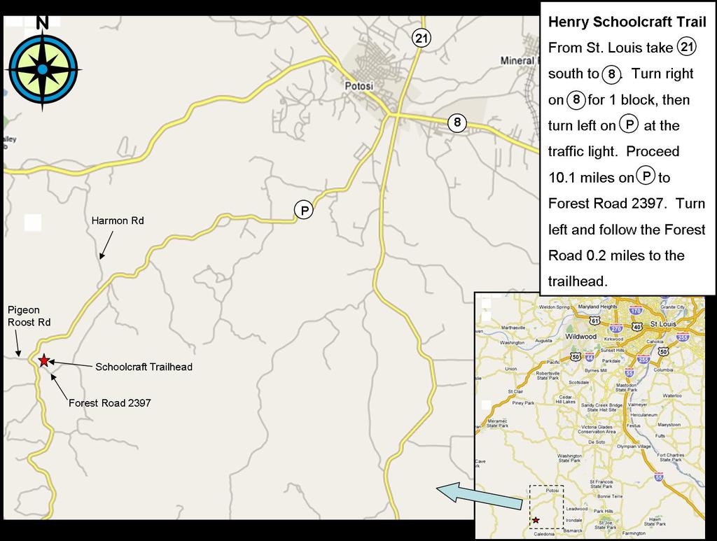
2 INFORMATION FOR HIKERS Trailhead The Schoolcraft trail is in Washington County, Missouri. The map provided in these instructions works quite well. Those hikers desiring a higher level of map detail should carry copies of the 7.5 minute topographic maps of the Palmer and Shirley quadrangles and sketch the trail route on these maps before starting the hike. To reach the trailhead from the Highway 21 Highway 8 intersection, go west on 8 one block to Route P. Go south on Route P 10.1 miles to FR 2397 on the left. (FR 2247, known locally as Pigeon Roost Rd., can serve as a landmark; it joins Route P on the right approx. 0.3 miles before reaching FR 2397.) Turn left on FR 2397 and go 0.2 miles to the trailhead, Pt A on the trail map. Park off the road, being careful not to block it. Trail Distances In the instructions below, distances between points are given in paces. The pace, as used in these instructions, means TWO thirty inch steps (i.e., a pace equals 5 ft). The pace measurements given are approximate, but are believed to be accurate to within ±10%. Compass Bearings The bearings given are as read compass bearings. Do not correct for the magnetic deflection from true north. Trail Markers Unless stated otherwise in the hike instructions, you will find a painted Appalachian Trail style double blaze (two 2 x 4 vertical rectangles) on a tree at each turning point on the trail. Turning points are labeled with a letter or number in the hike instructions. The double blaze will confirm that you are on the beam. Several turning points are marked with both a double blaze and rock cairn. But remember that double blazes can disappear when trees are cut or blown down. If you find a double blaze missing at a turning point, please mention this in your hike report, giving the point number or letter, so that the blaze can be replaced promptly. (If you can afford the time, add a few rocks to the cairns when you pass them. Some are rather small.) Emergency Exit If you become hopelessly lost before reaching Pt 5, take a due west (270 bearing) course to Route P. From Pt 5 to the end of the trail, take a due east (90 bearing) course to Route P. From any point along the trail you will reach Route P with no more than two miles of walking. Follow Route P left or right to walk back to your car at Pt A. Place Names Many of the place names on the trail are associated with Schoolcraft (see the Schoolcraft biography on page 1 of the trail instructions). Other designations honor National Forest employees and Scouters. Frank Myers was formerly Chief Ranger of the Potosi District of the Mark Twain National Forest (MTNF). Now retired, Myers laid out the well-known Berryman Trail in the Potosi District of the MTNF in Stuart N. Senniger was first Chairman of the Council s Historic Trails Committee, serving in this capacity from 1957 until He has been honored for his contributions to the Council s hiking program. Other place names will be recognizable as names from the Philmont Scout Ranch. Trail Camps Excellent sites for trail camps will be found at Pt Y, Schoolcraft Lake, and North Pond on the South Loop, and at Pt 10 and Pt 17 on the North Loop. Water will be available at these points except during extremely dry weather. All water should be treated before use. Campers should be careful with fire and should carry out all trash.
3 HIKING DIRECTIONS 1. General Notes Get organized. Take a compass, trail instructions and topographic (Palmer and Shirley quadrangle) maps. It will be helpful if at least one member of the group has earned the Orienteering Merit Badge. One individual should be designated as the pace counter. The pace counter should measure his pace before the hike and adjust the number of paces in the hiking instructions if his pace differs significantly from 5 ft per two steps. Start keeping track of your position at Pt A so that if you have to abort the hike you will know whether to turn right or left on P to go to your car. Under the best of conditions this trail will be a challenge. The careless and disorganized will not complete the hike! Start early if you want to take a one day hike and return home the same day. Allow 1½-2 hours to reach the trailhead from St. Louis (approx. intersection of Interstates 44 and 270) and start hiking by 8:30 am (9 am at the latest); otherwise darkness may overtake you before you finish the hike, especially in late fall through early spring. 2. South Loop Follow the instructions below from point to point. The reference points given are the ones shown on the trail map. Pt A to Pt B From the trailhead (a double blaze at the turnoff to the parking area from FR 2397), follow the forest road southeast about 220 paces to Pt B, where a faint logging road angles off to the right. Pt B to Pt C Follow this road in a generally southeast direction along a gradually descending ridge for 1000 paces to Pt C, a fork formed by the junction of a tributary creek with Clear Creek. (At 300 paces take the trail angling left of the logging road while continuing to follow the general direction of the ridgeline.) Pt C to Pt D Cross this tributary (an intermittent stream which enters Clear Creek from the left and may contain water) and go about 20 paces before continuing downstream on a 140 bearing which roughly parallels the left side of Clear Creek. It may be helpful to stay near the base of the hill to your left. Pt D, an intersection with a jeep trail, is about 260 paces from Pt C. Pt D to Pt E Go right 30 paces along the jeep trail to Pt E, where an abandoned road will intersect the road you are following from the right. Pt E to Pt F Turn right on the abandoned road. Follow this road, crossing Clear Creek in about 15 paces. Continue along an ascending NW ridge for about 380 paces to Pt F, which is at the top of the ridge. Pt F to Pt G Turn left and go cross-country on a 230 bearing, following a broad, descending ridge for 200 paces to a creek, Pt G. Pt G to Pt H Cross the creek and turn left. Follow the creek downstream in an east/southeast direction for 160 paces to where a small spring branch comes in from the right, Pt H. Pt H to Pt I Cross the spring branch and follow a 150 bearing 42 paces to Pt I. Pt I to Pt J Take a 190 bearing and go 250 paces, rising up the ridge until you intersect a faint road at Pt J. Pt J to Pt K Follow this road uphill in a southwesterly direction for 175 paces to Pt K, where it intersects a main forest road. Pt K to Pt L Turn left on this road and go east/southeast for 155 paces to a junction with a road which comes in from the right, Pt L. Pt L to Pt M Turn right on this road (in slightly east of south direction) and proceed down the ridge. At 550 paces you will have started to ascend the first small rise in the ridge, where the road turns to the left. This is Pt M. Pt M to Pt N Turn right and go cross-country at a generally 250 bearing down a broad ridge for 150 paces to Pt N, about 50 feet from where the ridge drops abruptly to the creek bottom.
4 Pt N to Pt O Turn left and go for 160 paces at a 160 bearing along the hillside to Miranda Meadows, Pt O, keeping the creek bottom on your right. Notice the sparkling quartz rocks on the hillside. Pt O to Pt P Follow a very faint path (approx 200 heading) for 30 paces to an old road. Continue on this road at a 135 bearing through a cedar grove past Beaubien Camp. At 340 paces from Pt O, a road comes in on the left. This is Pt P. Do not turn on this road. Pt P to Pt Q Continue to the east, crossing a creek at 185 paces (a good source of water). Continue on a faint logging road through the woods at a 105 bearing to Pt Q, which is about 15 paces past an intermittent stream crossing. Pt Q is 695 paces from Pt P. Pt Q to Pt R Grab a small rock for the cairn at Pt R. Turn left and proceed at a 5 bearing about 165 paces to Pt R, on the top of a small ridge. (Deposit your cairn rock.) Pt R to Pt S Veer to the left, staying on the ridge top, and continue for 180 paces at an approximate 330 bearing to Pt S, which is a definite high point at a tree on the crest of the hill. Pt S to Pt T Veer to the right and follow a 0 bearing (due north) along the crest of a long saddle on the ridge. Continue due north on this ridge to Pettibone Pond (on your right), at Pt T, about 220 paces from Pt S and a few paces north of the pond. Pt T to Pt U From the north side of the pond go 50 paces due north to a road, Pt U. Pt U to Pt V Turn left and follow the road, generally along a 325 bearing, about 440 paces to an intersection with a main forest road, Pt V. Pt V to Pt W Turn right on this road and go 130 paces to Pt W, which is marked by twin pines on the right side of the road and a double blaze. Pt W to Pt X Turn left and follow a generally 0 bearing down the ridge and nose for 360 paces to an intersection with a road, Pt X. (Good water source about 20 paces to the right.) Pt X to Pt Y Turn left on the road and cross Clear Creek in about 60 paces. Continue on the road, following a generally 300 bearing, about 200 paces from the Clear Creek crossing, to Pt Y, where a steep, uphill road interects on the right. Note the hunters campsite on the left. Note also that the steep road is about 50 paces past the end of a significant cliff about ft back from the road on the right. Pt Y to Pt Z Turn right onto the steep road (40 bearing) and follow it up the steep ridge nose 195 paces to the top of the first knob, Pt Z. Pt Z to Pt AA Veer left and follow the logging road along the peak of Senniger Ridge at a generally 5 bearing for about 500 paces to a rock cairn and double blaze, Pt AA, which is about 20 paces short of a logging road on your right. Pt AA to Pt BB Turn left and follow a 255 heading for 280 paces to the east side of Schoolcraft Lake, Pt BB. (At 80 paces from Pt AA you cross a logging road.) Pt BB to Pt CC Turn right and go about 75 paces along the eastern shore of the lake across a small valley and up into a grove of pines. This is a wonderful camping spot overlooking the lake just uphill from a point jutting out into the northwest shore. From the pine grove head up the ridge at a 30 bearing along a faint trail for about 230 paces. At this point the ridge changes direction. Follow at a 50 bearing for another 130 paces to an intersection with a dirt road, Pt CC. Pt CC to Pt DD Turn left and follow the road about 160 paces to a fork, Pt DD. Pt DD to Pt EE Turn left (approximately north) onto the side road which quickly turns to a 320 bearing and follow it for 65 paces to where a road comes in from the right (FR 2397). This intersection is Pt EE.
5 Pt EE to Pt FF Continue at 290 on FR 2397 for 695 paces to a junction with FR 2397A, Pt FF. Pt FF to Pt GG Turn right on this road and proceed north for 350 paces to a slight rise in the ridge, Pt GG. A rock cairn and double blaze on the left of the trail mark this point. (At 170 paces you will pass North Pond, a nice spot to take a break or camp. The pond will be on your right.) Pt GG to Pt HH Leave the road on a 300 bearing and follow a descending ridge nose for 400 paces into and across Butcher Gulch to a faint road 6 paces east of a creek bed, Pt HH. Pt HH to Pt 1 Turn left on this old road and follow it at a 210 bearing, paralleling the intermittent stream bed in Butcher Gulch for 155 paces to a rock cairn just past the east side of a rock outcrop on your right across the creek. THIS ROCK CAIRN AND TWO DOUBLE BLAZES ON OPPOSITE SIDES OF THE SAME TREE MARK THE STARTING POINT OF THE NORTH LOOP HIKE. THIS HIKE IS DESCRIBED IN SECTION 3, BELOW. Pt 1 to Pt II To complete the South Loop hike, continue past the cairn along the old road, which crosses the creek at 100 paces. At another 40 paces, there is a rock cairn just prior to crossing the creek again. Turn at the cairn and follow a 235 bearing for 170 paces to Pt II (about 310 paces from Pt 1). Pt II to Pt A Crossing the faint creek bed, go 50 paces at a 155 bearing to the old logging road. Turn right on the logging road, which follows the ascending ridge in a generally southwest direction to the trailhead at Pt A (350 paces from Pt II). 3. North Loop To start the North Loop hike, backtrack from the trailhead to the rock cairn between Pts. HH and II (see above), which is designated as Pt 1 for the North Loop hike. Pt 1 to Pt 2 From the rock cairn, cross the creek at a 280 bearing to pick up a path on the other side. Go left on the path as it parallels this creek and then follows the right fork in the creek. Continue following the right creek fork in a generally 280 bearing past a draw that comes in from the right and on to Pt 2, another fork in the creek. Pt 2 is 320 paces from Pt 1 and is marked by a rock cairn and a double blaze. Pt 2 to Pt 3 Follow the right fork of the creek (which is quite rocky) at a 295 bearing for 65 paces to Pt 3, a 2- wire power line. Pt 3 to Pt 4 Continue hiking up the rocky draw for 68 paces to Pt 4, a major fork in the draw. Pt 4 to Pt 5 Follow a 325 bearing from the fork up the steep nose between the two draws for 120 paces to Pt 5, across the paved Route P to its junction with gravel road FR Watch for oncoming cars! Pt 5 to Pt 6 Follow FR 2472 for 102 paces to Pt 6, where a dirt logging road angles off to the north from FR Pt 6 to Pt 7 Follow the dirt logging road along a ridge for 385 paces to Pt 7. Pt 7 to Pt 8 Continue along the road at a 45 bearing for 570 paces (At 200 paces another trail forks left. Stay right!) down a gentle ridge to Pt 8, which is in a saddle and marked with a rock cairn and double blaze. Pt 8 to Pt 9 Turn left and head 260 down a well-defined small ridge between two draws. Go for 150 paces to Pt 9, which is on the near side of a north-south creek. Pt 9 to Pt 10 Turn north and follow the creek for 290 paces to Pt 10, where the creek passes under a major hightension power line. (No double blaze here.) Pt 10 to Pt 11 Turn left at a 275 bearing and follow the clear-cut under the power line for 150 paces to Pt 11, where FR 2472 passes under the power line. (No double blaze here.) Pt 11 to Pt 12 Turn left at a 210 bearing and follow FR 2472 down then up a steep hill for 155 paces to Pt 12, where a logging road joins FR 2472 from the right.
6 Pt 12 to Pt 13 Turn right at a 300 bearing on the logging road and follow it for 260 paces back to the power line at Pt 13. (There are some nice scenic views over the cleared area to the left of the road.) (No double blaze here.) Pt 13 to Pt 14 Follow the power line at a 285 bearing down a steep hill for 240 paces to a logging road on the left, Pt 14. (About 20 paces before this point there is a creek which also passes under the power line and which will need to be crossed.) Pt 14 to Pt 15 Turn left on the logging road, which goes up a large creek valley at a 195 bearing, and continue for 325 paces to Pt 15, where a usually dry creek comes in from the right. Pt 15 to Pt 16 Cross the dry creek. (Do not follow the logging road which ascends the ridge!) Continue on a 175 bearing, in the general direction of the main creek, for about 285 paces. Here, at Pt 16, the right bank of the creek is caved in where a minor fork enters from the right. Pt 16 to Pt 17 Taking a 170 bearing, go 50 paces to the base of a north-south ridge nose, Pt 17. Pt 17 to Pt 18 Ascend the ridge (190 bearing) for 200 paces to the end of a generally north-south logging road, Pt 18. (Road is about 4 paces to the right of Pt 18.) Pt 18 to Pt 19 Follow the logging road in a generally southerly direction. Pick up a rock or two for the cairn at 300 paces that marks a trail junction. An ATV trail branches to the right. Stay left on the old logging road at a roughly 200 bearing. At 640 paces from Pt 18 will be the logging road s intersection with FR 2300, Pt 19. Pt 19 to Pt 20 Turn left on FR 2300 and follow the road at a 135 bearing. Continue under a power line and on to the intersection of FR 2300 with paved road FR 2247 (also known as Pigeon Roost Rd.). This intersection will be 600 paces from Pt 19. Pt 20 to Pt 21 Turn left on FR 2247, heading east for 90 paces to Pt 21. Here, a barely discernable abandoned road branches off to the right of the paved road. Pt 21 to Pt 22 Turn right on the abandoned road and follow it at 120 for 65 paces to Pt 22, the intersection of the abandoned road with paved Route P. Pt 22 to Pt 23 Cross Route P to the far side and hike the grassy shoulder of Route P at a 135 bearing for 220 paces to Pt 23, the intersection of Route P with gravel road FR 2397, which comes in from the left. Watch for oncoming cars! Pt 23 to Trailhead Relax; only a short way to go now! Turn left at a 60 bearing and follow FR 2397 for 138 paces back to the Schoolcraft trailhead. Congratulations! You have used these directions, topo maps and your compass to find your way on this difficult trail.
7 4. GPS Navigation For those who have a GPS and want a backup navigational aid, here are approximate GPS coordinates for each of the points on the trail. Point Latitude Longitude A 37 51' B 37 51' C 37 50' D 37 50' E 37 50' F 37 50' G 37 50' H 37 50' I 37 50' J 37 50' K 37 50' L 37 50' M 37 49' N 37 49' O 37 49' P 37 49' Q 37 49' R 37 49' S 37 49' T 37 49' U 37 49' V 37 50' W 37 50' X 37 50' Y 37 50' Z 37 50' AA 37 50' BB 37 50' CC 37 51' DD 37 51' EE 37 51' FF 37 51' GG 37 51' HH 37 51' II 37 51' ' ' ' ' ' ' ' ' ' ' ' ' ' ' Point Latitude Longitude ' '
8 ' ' ' ' ' ' '

9 Schoolcraft Trail North Loop

10 Schoolcraft Trail South Loop
11
Camp Geronimo Rainbow Trails
 Camp Geronimo Rainbow Trails With over 5,000 acres of surrounding national forest, the possibilities of getting out and seeing the wilderness are almost limitless. Camp Geronimo offers some of the greatest
beach. Make the ford and follow the trail out to the junction with Red Creek Tr in an open grassy area.
 Description: This is a moderate to slightly strenuous 22.8 mile backpack (add 2.6 miles if you do the packless out and back to the Lion s Head) that will have you exploring nearly every thing that is The
Trail Beginning Elevation: 7553 ft The Poison Creek Trailhead is located at the end of National Forest Road 646E (NF-646E).
.") West Mountain Trails Poison Creek Trail #134 Length: 2.9 miles (4.7 km) Difficulty Horseback: A good trail for the first time west mountain rider, some steep sections Hiking: Most Difficult USGS Maps:
West Mountain Trails Poison Creek Trail #134 Length: 2.9 miles (4.7 km) Difficulty Horseback: A good trail for the first time west mountain rider, some steep sections Hiking: Most Difficult USGS Maps:
playwinterpark.com Off The Beaten Path Hikes Hiking Recommendations for the Adventurous Hiker
 playwinterpark.com Off The Beaten Path Hikes Hiking Recommendations for the Adventurous Hiker Hike: Devil s Thumb (difficult) Length: 3.93 miles one-way Elevation: Trailhead 9609 Destination 12,236 Trailhead
Hiking Las Vegas.com
 Hike: Mt. Wilson via First Creek Canyon route Trailhead: First Creek marked Distance: 10 miles up and back Elevation gain: 3,400 feet Elevation of Peak: 7,070 feet Time: 7 to 9 hours (up and back) Difficulty:
Route #2) Mt. Massive - Southwest Slopes
 Mt. Massive - Southwest Slopes") Route #2) Mt. Massive - Southwest Slopes Difficulty: Class 2 Ski: Advanced, D6 / R2 / III Exposure: Summit Elevation: Trailhead Elevation: Elevation Gain: Round-trip Length: Trailhead: County Sheriff:
Route #2) Mt. Massive - Southwest Slopes Difficulty: Class 2 Ski: Advanced, D6 / R2 / III Exposure: Summit Elevation: Trailhead Elevation: Elevation Gain: Round-trip Length: Trailhead: County Sheriff:
Below is an example of a well laid-out template of a route card used by the Sionnach Team which is a good format to begin with.
 Route Card A route card is used as a navigational aid to hill walkers by setting out a step by step plan for an intended hike. It is good practice to make out a route card before every hike you or your
Route #1) Mt. of the Holy Cross - North Ridge
 Mt. of the Holy Cross - North Ridge") Climbing 14ers can be very dangerous, please read the Mountaineering Safety Page and make sure you have a map+compass and can use them effectively, without the help of electronic devices. Route #1) Mt.
Climbing 14ers can be very dangerous, please read the Mountaineering Safety Page and make sure you have a map+compass and can use them effectively, without the help of electronic devices. Route #1) Mt.
Marilla Reservoir to Chestnut Ridge via Marilla Trails and Bullis Hollow Trail east to west
 USGS topographic maps useful to this hike are the Bradford and Stickney 7.5 minute sectionals. These notes are designed to assist in identifying distance and location using geophysical and man-made characteristics
Lava Mountain Trail Distance: Elevation Range: Trail Type: Difficulty: Season: Driving Distance: Driving Time: USGS Maps: Pros Cons
 Lava Mountain Trail Distance: 13.4 miles (including the side trip to North Star Lake) Elevation Range: 5900'-8330' Trail Type: singletrack Difficulty: moderate Season: late June-October Driving Distance:
Rogue Gorge (Mt. Stella) Roadless Area-- T30S R3E (primarily in portions of Sections 23, 26, 33, 34 & 35)
 Roadless Area-- T30S R3E (primarily in portions of Sections 23, 26, 33, 34 & 35)") Rogue Gorge (Mt. Stella) Roadless Area-- T30S R3E (primarily in portions of Sections 23, 26, 33, 34 & 35) Rogue River-Siskiyou National Forest--High Cascades Ranger District Upper, higher elevation trail
Rogue Gorge (Mt. Stella) Roadless Area-- T30S R3E (primarily in portions of Sections 23, 26, 33, 34 & 35) Rogue River-Siskiyou National Forest--High Cascades Ranger District Upper, higher elevation trail
C E N T R A L C A T S K I L L S
 120 C E N T R A L C A T S K I L L S Central Catskills Once out of the southern parts of the Catskills, the Long Path enters the more well traveled and civilized regions. The trail joins the Devil s Path,
Trail Phasing Plan. Note: Trails in the Clear Creek Canyon area (Segments will be finalized in the future to minimize wildlife impacts
 Note: Trails in the Clear Creek Canyon area (Segments 2 5 and a future JCOS connection) will be finalized in the future to minimize wildlife impacts Trail Phasing Plan P Parking 3 Easy Trail Intermediate
GIFFORD PINCHOT NATIONAL FOREST
 GIFFORD PINCHOT NATIONAL FOREST 9341 Wright Meadow 93 Spencer Meadow Spencer Butte 4247' 30 30A 19 24 80 31C Lewis River Lower Falls 5 Quartz Creek 90 Taidnapam Falls Upper Falls 31 Spencer Peak 3861'
Camp Jack Wright PERMANENT ORIENTEERING COURSE (2004)
") Camp Jack Wright PERMANENT ORIENTEERING COURSE (2004) WHAT IS ORIENTEERING? The skill which enables a person to navigate with a map. In the competitive sport, the winner is the person who finishes in the
Camp Jack Wright PERMANENT ORIENTEERING COURSE (2004) WHAT IS ORIENTEERING? The skill which enables a person to navigate with a map. In the competitive sport, the winner is the person who finishes in the
Cherokee Hiking Club Trail Blurb
 Cherokee National Forest Trail #164 Distance: 6.2 miles Elevation Change: 2280 feet High Point: 3692 feet (Waucheesi Mountain) Low Point: 1412 feet (Wildcat Creek) Trail Rating: Moderately Strenuous (NW
Section 7: Pick Up Where You Left Off! S-Tree Road over the Todd Road
 2018 TRACE NOTES Helpful information for your adventure on Section 7 of the Hiker Challenge. Start Point S-Tree Rd. End Point Intersection Todd Rd. / Hale Ridge Rd. WEATHER DECISION Weather Alert!!!! Potential
S H A W A N G U N K R I D G E T R A I L
 214 Shawangunk Ridge Trail The Shawangunk Ridge Trail was originally conceived as a relocation of the Long Path from Harriman State Park to Minnewaska State Park. Now part of the Long Path system, the
West Trails Trek Guide. Chief Pontiac Trail Credential Hikes
 West Trails Trek Guide Kensington Start Edition Chief Pontiac Trail Credential Hikes RDS.WTW.110609 WP# Dist. Accum. Dist. Accum. Feet Miles Meters Meters 1 0 0.0 0 0 2 410 0.1 125 125 3 164 0.1 150 275
HAVE A GREAT HIKE AND ENJOY!
 BAKER LAKE HIKE #5634 & #234 (Moderate to Strenuous walking sticks recommended) DIRECTIONS TO TRAILHEAD: From Triple Creek s driveway, turn left on West Fork Road and drive about 1.3 miles (just past mile
Asheville & WNC Hikes
 Asheville & WNC Hikes Amazingly, we have 3,000+ miles of free public hiking trails near Asheville, including 1,600 miles in the Pisgah and Nantahala National Forests, 850 miles in Great Smokey Mountains
Stephens State Park Trails
 TRAILS OF ALLAMUCHY MOUNTAIN & STEPHENS STATE PARKS Allamuchy Mountain and Stephens State Parks contain 28 marked trails providing access to diverse landscapes for walking, hiking, biking, bird-watching,
CIEC 9 PEAKS AWARD SUPPLEMENT POSSIBLE ROUTES FOR THE 9 PEAKS AWARD TRIP
 CIEC 9 PEAKS AWARD SUPPLEMENT POSSIBLE ROUTES FOR THE 9 PEAKS AWARD TRIP As you plan your trip, be aware of 3 regulations in this wilderness: 1. Camp only in designated campsites. 2. No campfires allowed.
Telluride-to-Moab Alternative Singletrack Options
 Telluride-to-Moab Alternative Singletrack Options Day 1 Day 1 Alternate 1: Galloping Goose to Deep Creek. 18.4 miles, ascent 3,530ft, descent 1,388ft. This is fun, flowey, moderate to intermediate singletrack
Non-motorized Trail Plan & Proposal. August 8, 2014
 Town of Star Valley Ranch, Wyoming and the Star Valley Ranch Association in partnership with the USDA Forest Service, Bridger-Teton National Forest, Greys River Ranger District Non-motorized Trail Plan
County Line trail - Miller Peak to Little Navaho
 County Line trail - Miller Peak to Little Navaho 7-17-2008 This hike features a portion of the County Line trail in the Teanaway that receives extremely little use despite offering a spectacular ridge-run
Leaden Boot Challenge ROUTE INSTRUCTIONS
 Leaden Boot Challenge ROUTE INSTRUCTIONS Section 1 Alstonefield to Ilam From the village hall car park turn R then L and pass through the village keeping to the R to enter Church Street. Pass the Church
The gorges of Mohican Park in Ohio create a hiker's paradise Sunday, May 22, 2011 By Bob Downing, Akron Beacon Journal
 Pittsburgh Post-Gazette The gorges of Mohican Park in Ohio create a hiker's paradise Sunday, May 22, 2011 By Bob Downing, Akron Beacon Journal Bob Downing Big Lyons Falls drops 80 feet into a shady U-shaped
Leaden Boot Challenge 2016 ROUTE INSTRUCTIONS
 Leaden Boot Challenge 2016 ROUTE INSTRUCTIONS Section 1 Alstonefield to Ilam (CP2) From the village hall car park turn R then L and pass through the village keeping to the R to enter Church Street. Pass
H U D S O N P A L I S A D E S
 14 H U D S O N P A L I S A D E S Hudson Palisades The southernmost sections of the Long Path follow the Hudson River and the Hudson Palisades north, staying close to the river and to civilization. Although
A DESERT CAMPING GUIDE FOR ANZA BORREGO DESERT STATE PARK
 A DESERT CAMPING GUIDE FOR ANZA BORREGO DESERT STATE PARK With over 500,000 acres of beautiful terrain, Anza Borrego Desert State Park offers endless opportunities for Boy Scout Troops, Venture Crews and
Route Combo) Mt. Bierstadt - Bierstadt, Sawtooth, Evans
 Mt. Bierstadt - Bierstadt, Sawtooth, Evans") Climbing 14ers can be very dangerous, please read the Mountaineering Safety Page and make sure you have a map+compass and can use them effectively, without the help of electronic devices. Route Combo)
Climbing 14ers can be very dangerous, please read the Mountaineering Safety Page and make sure you have a map+compass and can use them effectively, without the help of electronic devices. Route Combo)
COURSE DESCRIPTION AND DIRECTIONS
 COURSE DESCRIPTION AND DIRECTIONS START TO BOUNTIFUL B (MILE 0 to MILE 17.05) From the start at East Mountain Wilderness Park, go past the green metal gate of East Mountain Wilderness Park and follow the
Skiing and Snowshoes on Un-groomed Fernan Saddle Terrain
 Skiing and Snowshoes on Un-groomed Fernan Saddle Terrain Three ski or snowshoe routes are available from the Fernan Saddle Parking Lot which either do not cover routes ordinarily groomed for snow machine
Trail Details Location
 Blind Blue Ribbon Centennial Conditions: Forest trail, with duckboards, and rope railing. Need: Blind trail activity bag, available in the camp office. None Availability: Open all seasons. Use the outdoor
16.5 Mile Trek Guide. Chief Pontiac Trail Credential Hikes RDS.H
 16.5 Mile Trek Guide Chief Pontiac Trail Credential Hikes RDS.H.110609 WP# Dist. Feet Accum. Miles Dist. Meters Accum. Meters 1 0 0.0 0 0 2 961 0.2 293 293 3 820 0.3 250 543 4 866 0.5 264 807 4a 407 0.6
Crystal Lake Area Trails
 Lake Area Trails Welcome to the Lake area of the Big Snowy Mountains! This island mountain range in central Montana features peaks reaching to 8,600 feet and long, high ridges from which vistas of the
AOTA ArtTrek Locations
 AOTA ArtTrek Locations ArtTrek is a summer-long Grand County, CO art adventure. Highlighted by snow-covered mountain vistas and rolling meadows threaded with sparkling streams and rivers, numerous sites
Hiking Trail Descriptions
 Hiking Trail Descriptions For ye shall go out with joy. And be led forth with peace. The mountains and the hills shall break forth before you in singing. And all the trees of the fields shall clap their
Driving Time: 3 hours (allow extra time for stops)
") Scenic Byways loop This journey takes visitors through the eastern edge of Mt. Rainier National Park and along two of Washington s most beloved scenic byways, the Chinook Byway and the White Pass Scenic
Scenic Byways loop This journey takes visitors through the eastern edge of Mt. Rainier National Park and along two of Washington s most beloved scenic byways, the Chinook Byway and the White Pass Scenic
Washington Section I - Page 1 WGS84 Zone 10T m
 73 N. 72 N. 71 N. 70 N. 69 N. 68 N. These maps are provided as a free service to PCT hikers. I believe the information is accurate but they may contain errors. The maps are distributed in the hope that
Introduction to Topographic Maps
 Introduction to Topographic Maps DIRECTIONS: Read all of the following content. READ EVERYTHING!! At the end of the packet, you will find two topographic maps. Your task is to indentify each of the elevations
Sunday / Monday - Osceolas
 AMC August 3, 2015 Sunday / Monday - Osceolas 0 1737 ft 2007, Appalachian Mountain Club. All rights reserved. Notes Created by AMC White Mountain Guide Online wmgonline.org 1 Distance Time Elev Change
Royal Gorge Far Out Trail to Le Point
 Royal Gorge Far Out Trail to Le Point Direction to trailhead: From East Ridge Campground: Drive west from Canon City on US 50 to County Road 3A, the entrance road to the Royal Gorge Park. Turn left onto
MAROON BELLS SNOWMASS WILDERNESS - COLORADO LYC ADVENTURE TRIP ITINERARY 2018
 MAROON BELLS SNOWMASS WILDERNESS - COLORADO LYC ADVENTURE TRIP ITINERARY 2018 Tuesday, July 31, 2018 3:00 6:30pm Check-in & Dinner Preparations at accommodations 3:00 to 5:00pm Staff & Camper Arrival (Airport
Note: Coordinates are provided as Universal Transverse Mercator UTM Zone U21, North American Datum 1983 (NAD 83).
.") Northern Traverse Route Description The Northern Traverse (formerly the North Rim Traverse) is an unmarked and rugged backcountry hiking route. It is known be a demanding hike, because of its terrain and
Northern Traverse Route Description The Northern Traverse (formerly the North Rim Traverse) is an unmarked and rugged backcountry hiking route. It is known be a demanding hike, because of its terrain and
Eagle Rock Loop Ouachita National Forest Page 1 of 8
 EAGLE ROCK LOOP Eagle Rock Loop Ouachita National Forest Page 1 of 8 Hiking: Biking: Equestrian: Trail Highlights: This trail offers the longest loop trail in Arkansas. A combination of the Little Missouri,
Hiking Las Vegas.com
 Hike: Juniper Peak up and back Trailhead: Oak Creek Canyon marked Distance: 5.5 miles round trip Elevation gain: 2,200 feet Elevation peak: 6,109 feet Time: 4 to 5 hours - Up and back Difficulty: 3 Danger
Anderson Mt. Proposed Wilderness Additions to the Rogue-Umpqua Divide Wilderness-- T30S R3E (mostly) Sections 4 & 9, and T29S R3E Section 33
 Sections 4 & 9, and T29S R3E Section 33") Anderson Mt. Proposed Wilderness Additions to the Rogue-Umpqua Divide Wilderness-- T30S R3E (mostly) Sections 4 & 9, and T29S R3E Section 33 When the 35,701 acre Rogue-Umpqua Divide Wilderness was designated
Anderson Mt. Proposed Wilderness Additions to the Rogue-Umpqua Divide Wilderness-- T30S R3E (mostly) Sections 4 & 9, and T29S R3E Section 33 When the 35,701 acre Rogue-Umpqua Divide Wilderness was designated
Griffith Park Trail Run Trail Guide Click for
 The Griffith Park Trail Run by Hike- LosAngeles.com Griffith Park Trail Run Trail Guide Click for downloadable cell phone guide and map from EveryTrail. DISTANCE: 4.55 Miles ELEVATION: 1280' ELEVATION
MP : Headwaters of the Fraser River
 MP 236 237: Headwaters of the Fraser River The mile between these two mileage posts is often just referred to as the bottom switchback or the curve at the bottom of Berthoud Pass. For many locals this
GOLDEN EARS PROVINCIAL PARK
 GOLDEN EARS PROVINCIAL PARK Trail Information as of October 10 th 2015 Do not underestimate the mountainous wilderness of Golden Ears Provincial Park. The combination of rugged terrain and rapidly changing
Isle Royale Info Trip Packages. The Greenstone Ridge Trail
 s East Section West Section Total Miles 42.7 Difficulty East to West 6.884 Difficulty West to East 6.965 [This is based on 7 Day Shorter Miles sample itinerary. However, difficulty is close to the same
Black Hill Regional Park, Little Seneca Lake
 Black Hill Regional Park, ittle Seneca ake ittle Seneca ake, in Black Hill Regional Park, is a reservoir created after a previous drought struck the Washington area. The park is under Maryland-National
Beaver Country Trails ATV Jamboree
 Beaver Country Trails ATV Jamboree #1 Lincoln Mine Intermediate (Open to all ATVs/UTVs) 34 Miles Highlights: This ride will highlight the historic Lincoln Mining District, the first lead mine in Utah,
Blue Ridge Hiking Club Hike List July- September 2016
 Blue Ridge Hiking Club Hike List July- September 2016 Saturday, July 2, Elk Knob: 3.8 mile round trip with 900 ft. gain in elevation. Spectacular views at the summit. The trails are mostly moderate, but
BEGINNER. mayorsmtbchallenge.org
 mayorsmtbchallenge.org Redding s second local Mountain Bike Challenge uniting current and new bicyclists in a friendly self-competition highlighting our diverse trail system. BEGINNER N Churn Creek Greenway
throu Booth Hill Green Belt
 s k r a p s l l u b m u r T Explore gh Geocaching throu Booth Hill Green Belt This was originally a concept to try and preserve some of the land in our town, without hurting the developers that are creating
A Publication of Friends of Sleeping Bear Dunes
 A Publication of Friends of Sleeping Bear Dunes 2014, Friends of Sleeping Bear Dunes, P.O. Box 545, Empire, MI 49630 www.friendsofsleepingbear.org info@friendsofsleepingbear.org Learn more about the Friends
Trail Notes Palouse Region Hikes
 Trail Notes Palouse Region Hikes Campus Recreation 875 Perimeter Drive MS 1230 Moscow, Idaho 83844-1230 Ph: 208.885.6810 Rentals: 208.885.6170 Fax: 208.885.6879 uidaho.edu/outdoorprogram 0 PALOUSE REGION
UMASS CROSS-COUNTRY Trails
 UMASS CROSS-COUNTRY Trails 1) EGG (43 min) (A) From Cage proceed to North Pleasant street (by campus pond). Make left and head toward LGRT and pass School of Education. Pass Puffton Apt complex (on left)
PRIEST LAKE TRAILS. More information contact: Priest Lake Ranger District
 PRIEST LAKE TRAILS The varying terrain in the Priest Lake area ranges from river bottoms with an elevation of 2,600 to 7,500 ft. Valley bottoms, dense forests, meadows and occasional clearings and barren
Road Scholar Gopher Science Olympiad Invitational January 6, Team #: Team Name: Names: Score:
 Road Scholar Gopher Science Olympiad Invitational January 6, 2018 Team #: Team Name: Names: Score: Welcome to Road Scholar! Your Science Olympiad team is planning a trip to an invitational tournament in
Mazatal Wilderness Trails
 Mazatal Wilderness Trails "Mazatzal" to the Paiute means, "empty space between". The Mazatzal Wilderness Area is located in central Arizona between the Verde River on the west and the Beeline Highway (Arizona
Oregon Section F - Page 1 WGS84 Zone 10T m
 08 N. 07 N. 06 N. Oregon Section F - Page 1 WGS84 Zone 10T LavaCampLakeTR - Lava Camp Lake Trail #4060 junction. - mi 1982.6-5287 ft LavaCampLake - Lava Camp Lake, campground, outhouse, 1/2 mile NE of
Dnigi Hut. Dnigi is Dnaina for Moose. Location:
 Dnigi Hut in places. Stay on the main thoroughfare. Continue along the ridge top, going east to a pass above Knob Creek. Just beyond here look for a left turn which descends north-northwest (61,45.578,-148,52.414,2081
Bradshaw Trails Series
 Bradshaw Trails Series Curtis James Troop 7014 Curtis.James@erau.edu My Motto: Never get lost! Hiking Rules Bradshaw Hiking Patch Series Hiking Tools Hiking Rules Hiking Merit Badge* Take five 10-mile
Location: Height: Access: Distance: Elevation: Season: Difficulty: Lat/Long: Directions:
 Upper Eagle Falls Upper Eagle Falls (~20 ft.) is a short hike up from the roadside at the Eagle Falls picnic area. It is very difficult to get a parking spot here during the day, so it is recommended to
Massanutten Mountain Cluster
 Massanutten Mountain Cluster Signal Knob Catback Mountain Southern Massanutten Mountain Five areas of almost 49,000 acres on the Lee Ranger District compose the Massanutten Mountain Cluster of Mountain
Oman Trek Trek the dramatic and beautiful scenery of Oman
 Oman Trek Trek the dramatic and beautiful scenery of Oman Discover Oman on this breath taking 5 day challenge. The mountain ranges and deserts of Oman offer spectacular trekking, and enables you to experience
Friday October 3. Lower Javelina Trail - Level D. about 3 miles, less than 500. Hike Contact: Joel Tormoen
 Friday October 3 Lower Javelina Trail - Level D. about 3 miles, less than 500 Hike Contact: Joel Tormoen joeltormoen@gmail.com Depart WB trailhead 8:00 am - return before 11:00 am This quite easy hike
F.O.K.O.S. Friends of Kingston Open Space A GUIDE TO KINGSTON OPEN SPACE
 F.O.K.O.S. Friends of Kingston Open Space A GUIDE TO KINGSTON OPEN SPACE Friends of Kingston Open Space (FOKOS) was formed when a handful of concerned citizens joined together to learn what could be done
MOUNTAIN BIKING THE CASCADE LOOP
 MOUNTAIN BIKING THE CASCADE LOOP By Henry Freimuth All photographs by Henry Freimuth The Cascades are on the Spanish Creek, which is a tributary of the Feather River. The Feather River was named by Spanish
Adventures in the Rockies. 6 Days
 Adventures in the Rockies 6 Days Adventures in the Rockies On this action-filled adventure, experience two different sides to the Rockies on the western side, discover hidden gems that few visitors get
(west) onto Charleston Boulevard. Drive 16 miles on Charleston and turn right into Red Rock
 onto Charleston Boulevard. Drive 16 miles on Charleston and turn right into Red Rock") Hike: North Peak and Ice Box Overlook up and back Trailhead: 2.5 miles up the Rocky Gap Road not mark Distance: 5 miles round trip Elevation gain: 2,694 feet Elevation Peak: 7,094 feet Time: 3 to 5 hours
Hike: North Peak and Ice Box Overlook up and back Trailhead: 2.5 miles up the Rocky Gap Road not mark Distance: 5 miles round trip Elevation gain: 2,694 feet Elevation Peak: 7,094 feet Time: 3 to 5 hours
(Short Listing) SOUTH FORK LOG CABIN, UTICA, MONTANA
 SOUTH FORK LOG CABIN, UTICA, MONTANA") (Short Listing) SOUTH FORK LOG CABIN, UTICA, MONTANA The South Fork Log Cabin is in the heart of thousands of acres of public land of the Lewis & Clark National Forest Service. This Cabin offers unlimited
(Short Listing) SOUTH FORK LOG CABIN, UTICA, MONTANA The South Fork Log Cabin is in the heart of thousands of acres of public land of the Lewis & Clark National Forest Service. This Cabin offers unlimited
ABOUT THE PARKS NANTAHALA NATIONAL FOREST MOUNTAINS NATIONAL PARK CHEROKEE NATIONAL FOREST PISGAH NATIONAL FOREST GREAT SMOKY HIKING TRAILS
 ABOUT THE PARKS GREAT SMOKY MOUNTAINS NATIONAL PARK NANTAHALA NATIONAL FOREST CHEROKEE NATIONAL FOREST PISGAH NATIONAL FOREST GREAT SMOKY MOUNTAINS NATIONAL PARK Straddling the border between North Carolina
Mountain Biking and Off Road Trails in Warren County, New York
 Mountain Biking and Off Road Trails in Warren County, New York Warren County Safe and Quality Bicycling Organization 96 Country Club Road Queensbury, NY 12804 www.bikewarrenco.org Warren County Safe and
San Juan Hut Systems Telluride To Moab Route Description. Adventure without the weight
 San Juan Hut Systems Telluride To Moab Route Description Due to the inaccuracies caused by varying calibrations in odometers, you may notice some inaccuracies in the mileages listed for the Standard Route
Photographing Upper Peninsula Waterfalls
 Photographing Upper Peninsula Waterfalls Tod Poirier Freelance Photographer Photography is one of my passions. The following spread showcases several Upper Peninsula waterfalls. At times a single drop
Cincinnati Nature Center s
 120 60 hikes within 60 miles: cincinnati 24 Cincinnati Nature Center s Rowe Woods i KEY AT-A-GLANCE INFORMATION Length: 8.9 miles Configuration: Loop Difficulty: Difficult Scenery: Forest, ponds, prairie,
Rock Creek Park, MD - Lake Needwood
 ock Creek Park, MD - Lake Needwood Lake Needwood, is a reservoir located at the end of the north end of the ock Creek hiker-biker trail. At the other end, ock Creek empties into the Potomac iver near Thompson
GUIDE TO THE PINHOTI TRAIL IN GEORGIA
 GUIDE TO THE PINHOTI TRAIL IN GEORGIA TENTH EDITION, MAY 2016 Covers Sections 14 through 31 Alabama State Line to Benton MacKaye Trail Conasauga Ranger District of the Chattahoochee National Forest Simms
You ll turn the ridge about 80 feet above a small saddle leading north to an obvious rock summit (disrecommended because it requires the agility and
 Trailheads (THs) for Hikes in the National Forest near Glen Haven by Howard Pomranka 796 Columbine Drive, Estes Park (970)586-6166 or hpomranka@yahoo.com INTRODUCTION "The mountains don't care." Not only
Tiger Mountain State Forest:
 98 60 hikes within 60 miles: SEATTLE 20 Tiger Mountain State Forest: West Tiger Mountain Three Loop i KEY AT-A-GLANCE INFORMATION Length: 5.1 miles round-trip Configuration: Loop Difficulty: Moderate difficult
Date Name Trail Segment Conditions, Hazards and General Notes on Trails
 Trail Reports for Sawtooth NRA ***Unless otherwise reported-expect high creeks, snow levels at 7900 ft. and trees on trails. Due to high winds in the area, if trees were previously reported removed there
Date Name Trail Segment Conditions, Hazards and General Notes on Trails
 Trail Reports for Sawtooth NRA ***Unless otherwise reported-expect high creeks, snow levels at 7900 ft. and trees on trails. Due to high winds in the area, if trees were previously reported removed there
Other Agencies and Organizations
 Daniel Boone National Forest 1700 Bypass Road WInchester, KY 40391 859-745-3100 Location Northern terminus is near Morehead, Kentucky. Southern terminus is located in the Big South Fork NRRA in Tennessee.
Whiteside Mountain Land Owned by: Location: Trails:
 Whiteside Mountain Latitude: 35 05.123 N Longitude: 083 07.933 W Elevation: 1,503m Land Owned by: US Forest Service Nantahala Ranger District 828-524-6441 Location: Jackson County, NC Turn off of US Highway
Saturday Hike - Hancock Loop & Out
 AMC August 3, 2015 Saturday Hike - Hancock Loop & Out 0 2487 ft 2007, Appalachian Mountain Club. All rights reserved. Notes Created by AMC White Mountain Guide Online wmgonline.org 1 Distance Time Elev
Oregon Section B - Page m
 Oregon Section B - Page 1 5 35000m 5 36000m 5 37000m 5 38000m 46 57000m 46 58000m Hwy5B - Interstate Highway 5 - mi 1716.4-4271 ft RD1717 - PCT departs paved Old Highway 99 - mi 1716.8-4357 ft PL1717 -
Oregon Section C - Page 1 WGS84 Zone 10T m
 00 N. 99 N. 98 N. 97 N. 96 N. 557000m Oregon Section C - 74.4 miles Start - Hwy 140, mile 1773.4 (near Fish Lake) End - Hwy 138, mile 1847.8 (near Cascade crest) Elevation Gain +8,111' Elevation Loss -7,145'
Kitimat. Pacific Inland Coast. Hiking Guide Kitimat, British Columbia, Canada
 Kitimat Pacific Inland Coast Hiking Guide Kitimat, British Columbia, Canada 2010-2011 Sites and Trails Emergency Call 911 Police - Fire - Medical 2 Welcome to Kitimat This information was produced to assist
 Hike date Exertion Destination/ Leader(s) Description and Contact info Rating Hike Name 7/8-12/10 S+ Extreme Pleinair Sandy Compton Contact info: 208-290-1281 or sandy@scotchmanpeak.org This hike is nearly
CELEBRATE WEST GREENWICH GEOCACHING THROUGHOUT WEST GREENWICH
 CELEBRATE WEST GREENWICH GEOCACHING THROUGHOUT WEST GREENWICH The West Greenwich Land Trust (WGLT) is sponsoring Celebrate West Greenwich, an event designed to celebrate the beauty and history of scenic
A topographic map shows:,,,,
 Name: Period: Mapping the Earth Notes What is a map? Label the compass directions: What does latitude measure? What is the name of the 0 latitude line? Where is 90 north latitude? Where is 90 south latitude?
Suggested Day Hikes. Mount Greylock State Reservation 3, 4 1, 2. Take a Hike! Things to remember:
 Suggested Day Hikes Mount Greylock State Reservation Take a Hike! This guide offers suggested day hike routes in two parts: 1) Year-round Hikes and 2) Seasonal Hikes (late-may to Nov.1). Use this guide
Peak to Peak MST Segment 1A
 1 Mountains-to-Sea Trail Last Updated 1/1/2017 Peak to Peak MST Segment 1A View from the Mountains-to-Sea Trail at Clingmans Dome Photo by Danny Bernstein CLINGMANS DOME TO WATERROCK KNOB ALTERNATE ROUTE
Piestewa Peak/Dreamy Draw Trail Guide
 Piestewa Peak/Dreamy Draw Trail Guide Trail #1A - Perl Charles Memorial Trail Length: 4.8 miles Elevation: 2,200 ft. - 1,340 ft. Difficulty: Moderate to difficult The Perl Charles trailhead is located
Logan Canyon Hiking Trail Guide
 C a c h e V a l l e y V i s i t o r s B u r e a u Logan Canyon Hiking Trail Guide Monique Beeley Legend Trail Location Guide WASATCH CACHE NATIONAL FOREST WILDERNESS PAVED WATER TRAILHEAD 9 Logan River