Mt Kuring-gai Track to Berowra station
|
|
|
- Damian Rich
- 5 years ago
- Views:
Transcription


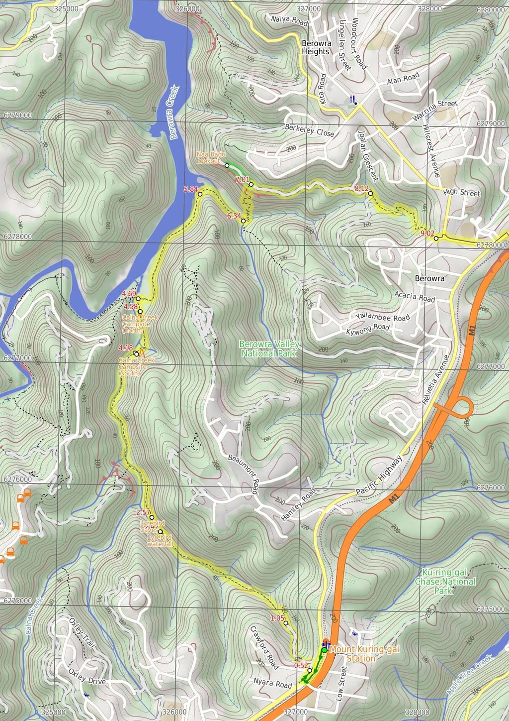
1 Mt Kuring-gai Track to Berowra station 4 hrs 15 mins 9.7 km One way Hard track 4 553m This walk explores three valleys, with great displays of wild flowers in spring, and some nice sandstone overhangs. The section between Mt Kuring-gai and the end of Calna Creek is particularly nice, and Naa Badu Lookout is well worth the small side trip. Take the time to enjoy the many creek side rest areas along the way. 221m 1m Berowra Valley National Park Maps, text & images are copyright wildwalks.com Thanks to OSM, NASA and others for data used to generate some map layers.

2 Lyrebird waterfall Before You walk This informally named waterfall is found on Lyrebird Gully creek about 300m upstream of its confluence with Calna Creek. The top of the fall is partially fenced with a timber handrail where the water flows over the solid rock platform, with naturally carved holes, to fall about 8m to the shallow pool and boulders below. The track passes the top of the fall and does not provide a good view of the face of the fall, but it is still a very pleasant spot. Bushwalking is fun and a wonderful way to enjoy our natural places. Sometimes things go bad, with a bit of planning you can increase your chance of having an ejoyable and safer walk. Before setting off on your walk check Lyrebird Caves The Lyrebird caves are a series of notable sandstone overhangs on the eastern side of Lyrebird Gully. There are 3 main overhangs, with the larger (more northern) one providing significant shelter. The larger cave has a fairly flat base in the centre and provides a pleasant place to rest on a hot or rainy day. Calna Creek Campsite (south) This small signposted campsite sits on a flat grassy clearing in a small casuarina forest which provides plenty of shade. There is a small fireplace set up. This creek-side campsite is a good spot for those wanting to get the most out of a relaxing, overnight camp, just a short stroll to Berowra Creek and the main spine of the Great North Walk. Bring your own water, as the creek water is not suitable for drinking. Calna Creek Campsite (north) This is a quaint little campsite, located on the Mt Kuring-gai access track to the Great North Walk, on the banks of Calna Creek. This campsite provides plenty of room for a few tents, and also a fire scar with logs for seating. Carry in your own water as the salty creek water is not suitable for drinking. Naa Badu Lookout Naa Badu Lookout offers magnificent views south over Berowra Creek as well as over Sams and Calna Creeks. Naa Badu means 'See water' in the Aboriginal tribal language of the Dharug people. It is believed that Berowra Creek was the boundary between the Dharug and Guringai Aboriginal peoples. The lookout is fenced, has a bench seat, picnic table and a fair amount of natural shade. 1) Weather Forecast (BOM Metropolitan District) 2) Fire Dangers (Greater Sydney Region) 3) Park Alerts (Berowra Valley National Park) 4) Research the walk to check your party has the skills, fitness and equipment required 5) Agree to stay as a group and not leave anyone to walk solo Think before you TREK The 'Think before you TREK' program developed by NSW Police & NPWS promotes the benefits of planning ahead for your bushwalking trip by using an easy to remember acronym: adequate supplies of food, water, navigation and first T Take aid equipment. your planned route and tell friends and family when R Register you expect to return. beacon (PLB's) should be carried on walks with E Emergency significant gaps in mobile coverage (check terrain profile). to your planned route and follow the map and walking K Keep trails. Topo Maps The maps provided on wildwalks are helpful, but there are times where you may need maps covering a broader area. Maps that cover this walk include; 1: Map Series:91304S HORNSBY, 91304N COWAN 1: Map Series:CMA Ku-ring-gai Chase National Park Tourist Map 1: Map Series:9130 SYDNEY Grade This walk has been graded using the AS The overall grade of the walk is dertermined by the highest classification along the whole track. 4 Grade 4/6 Hard track Length 9.7 km One way Time 4 hrs 15 mins Quality of track Rough track, where fallen trees and other obstacles are likely (4/6) Signs Directional signs along the way (3/6) Experience Required Moderate level of bushwalking experience recommended (4/6) Weather Storms may impact on navigation and safety (3/6) Infrastructure Limited facilities, not all cliffs are fenced (3/6)
3 Are you ready to have fun? Please ensure you and your group are well prepared and equipped for all possible hazards and delays. Check park closures, weather information and Fire Danger Rating before setting out. Optional side trips and alternate routes noted are not included in this walks overall grade, length or time estimate. Please allow extra time for resting and exploring areas of interest. The authors, staff and owners of wildwalks take care in preparing this information but will not accept responsibility for any inconvenience, loss or injury you may experience. Please take care, have fun - Happy Walking. Getting there You can get to Mt Kuring-gai Railway Station (gps: , ) by car, train or bus. Car: There is free parking available. You can get back from Berowra Station (gps: , ) by car or bus. Car: There is free parking available. Find up to date and more information inlcuding; travel directions, weather, park closures and walker feedback at 0 Mt Kuring-gai Railway Station (520 m 9 mins) From the middle of the tunnel at the bottom of the stairs at Mt Kuring-gai railway station, this walk follows the 'To the Great North Walk' sign through the tunnel to the Pacific Hwy. Here the walk turns left and follows the footpath between the highway and train line for about 200m to pass the traffic lights at Glenview Rd. The walk then continues straight up the ramp for another 100m and turns right onto the pedestrian bridge. Here the walk crosses the Pacific Hwy on the footbridge, then follows the concrete ramp as it zigzags back down to the ground. This ramp ends just near the Aldi shopping complex. From the bottom of the footbridge near the Aldi shopping complex, this walk follows the footpath alongside the Pacific Hwy, under the footbridge and away from the shops. Keeping the highway to your right for 100m, this walk then crosses 'Glenview Rd' (at the intersection with the Pacific Hwy) to find the top of 'Lyrebird Gully track', marked with a locked green metal gate Int of Glenview Rd and the Pacific Hwy (530 m 12 mins) Continue straight: From the intersection (of Glenview Rd and the Pacific Hwy), this walk follows the GNW arrow post around the locked 'Lyrebird Gully Track' gate, to head down the sealed management trail. The trail leads past a large 'To the Great North Walk' sign where the trail then bends left behind the houses and heads steeply downhill for about 500m, coming to the end of the sealed trail and a large flat clearing Lyrebird Clearing (1.4 km 27 mins) Continue straight: From the bottom of the sealed management trail, this walk follows the GNW arrow post across the clearing following the old dirt trail. After about 120m, this walk comes to another small clearing, where this walk turns left following the 'The Great North Walk' sign. The track then bends right and leads down to cross over a short flat timber bridge across a concrete channel. From here, the rocky track leads down along the side of the hill for about 150m before heading down some stone steps (with a handrail, under a set of power lines) to come to the 'Great North Walk register' box on a pole. After filling in your intentions (and reading others entries), this walk continues down along the track beside a rock wall, past a short section of handrail then down a series of timber and rock steps for about 300m to then cross Lyrebird Gully creek on the sandstone platform. This creek crossing and other crossing further down the valley can become impassable after heavy or prolonged rain. The walk then leads over the short section of green timber boardwalk, following the GNW arrow post uphill. The walk then follows the rocky track along the side of hill for about 250m to pass beside a rock wall (on your right) and a section of handrail and steep valley (on your left). Here the walk steps down a rock (with metal peg) to follow the rocky track downhill and come close to a creek. Here the walk follows the edge of creek (keeping the creek to your left) for just shy of 100m to then cross the creek using boulders with carved steps. Once one the other side of the creek, this walk crosses back again, almost immediately, following the handrail and flat timber bridge (note: this boardwalk/bridge was washed away during a flood in 2012, the hand rail is still in place) at the top of Lyrebird Gully falls to then find a 'The Great North walk' sign back on the other side Lyrebird waterfall This informally named waterfall is found on Lyrebird Gully creek about 300m upstream of its confluence with Calna Creek. The top of the fall is partially fenced with a timber handrail where the water flows over the solid rock platform, with naturally carved holes, to fall about 8m to the shallow pool and boulders below. The track passes the top of the fall and does not provide a good view of the face of the fall, but it is still a very pleasant spot Lyrebird Waterfall (140 m 4 mins) Continue straight: From near the top of Lyrebird Waterfall, this walk follows the GNW arrow post, away from the face of the 'The Great North Walk' sign up the timber steps. The track soon bends left to follow the side of the hill for about 50m and head through a sandstone overhang, then through a second smaller cave. Continuing along the side of the hill for another 70m, this walk comes to another larger sandstone overhang Lyrebird Caves The Lyrebird caves are a series of notable sandstone overhangs on the eastern side of Lyrebird Gully. There are 3 main overhangs, with the larger (more northern) one providing significant shelter. The larger cave has a fairly flat base in the centre and provides a pleasant place to rest on a hot or rainy day Lyrebird Caves (1.6 km 33 mins) Continue straight: From the large sandstone overhang, this walk follows the rocky track along the side of the hill, keeping the valley to your left. After about 40m, the track leads steeply down a short rocky slope where the track then continues along the side of the hill for another 200m before bending sharp left and zigzagging steeply down the stone steps to come to the edge of Calna Creek. The track continues along the side of the creek (on your left) through the shaded forest and past some large boulders for about 70m, to then follow a GNW arrow post across the creek using the boulders with carved steps. The track continues downstream (with the creek on your right) among ferns, for almost 300m, where another GNW arrow post leads back across Calna Creek using boulders with carved steps. The track continues among more ferns and mossy boulders, now with creek on your left, for 400m to where the track comes to the wide, clearly tidal section of Calna Creek, where there is a small sandy beach and open views down the valley. The mostly flat track continues down beside the wide creek for another 400m to cross over a flat timber bridge, then just 25m later, this walk comes to the signposted campsite, in casuarina forest Calna Creek Campsite (south) This small signposted campsite sits on a flat grassy clearing in a small casuarina forest which provides plenty of shade. There is a small fireplace set up. This creek-side campsite is a good spot for those wanting to get the most out of a relaxing, overnight camp, just a short stroll to Berowra Creek and the main spine of the Great North Walk. Bring your own water, as the creek water is not suitable for drinking Calna Creek campsite (south) (400 m 9 mins) Continue straight: From the campsite, this walk follows the clear track downstream, keeping Calna Creek to your left. After about 100m of walking through flat grassy area and casuarina forest, this walk leads over a timber bridge (with handrails) that crosses a small tidal creek. The now rocky track continues for another 180m, stepping over a fallen tree, to then climb up a short timber staircase. At the top of these stairs, the track leads over a rocky rise then back down where the track mostly flattens out for another 100m to come to a large, unsignposted clearing and campsite (on your right), just before the southern tip of the saltmarsh Calna Creek Campsite (north) This is a quaint little campsite, located on the Mt Kuring-gai access track to the Great North Walk, on the banks of Calna Creek. This campsite provides plenty of room for a few tents, and also a fire scar with logs for seating. Carry in your own water as the salty creek water is not suitable for drinking Calna Creek campsite (north) (110 m 2 mins) Continue straight: From the campsite, this walk follows the clear track south, keeping Calna Creek (though the trees) to your left. After about 100m, the track comes to a well signposted intersection just beside Calna Creek bridge Calna Creek Bridge intersection (1.1 km 27 mins) Turn right: From the intersection, this walk follows the 'Berowra Waters' sign along the timber boardwalk. The boardwalk leads for about 80m across the large open flat saltmarsh into the casuarina forest on the other side. Here the track bends left and leads along the side of the saltmarsh for almost 200m, where the rocky track leads a little further before coming alongside Berowra Creek's mangroves. The track continues to gently undulate along the side of Berowra Creek for about 650m among the casuarinas and grass tress, before heading up a fairly short, steep climb. At the top of this climb, the walk comes to a small, flat, pleasant clearing surrounded by large boulders Sams Creek ridge clearing (500 m 11 mins) Continue straight: From the clearing, this walk leads down the north eastern side of this ridge, keeping the main valley to your left. After about 100m this walk comes to another flat saltmarsh, where the track bends right to soon come to a large flat clearing beside Sams Creek (subject to flooding). The track then leads alongside Sams Creek (on your left) for about 350m when, just after climbing over a rock, the track comes to a 'Crosslands' sign pointing back along the track, beside the creek Sams Creek Crossing (670 m 30 mins) Turn left: From the south side of the creek, this walk follows the 'Berowra Waters' sign across the rocky Sams Creek. This creek may become impassable after heavy or prolonged rain. On the other side, the track veers left, crossing a rocky gully and heads up the timber steps. The track now starts to climb steeply, zigzagging up the timber steps and a couple of staircases for just over 300m to find a bench seat in a small sandstone cave. After a rest, this walk continues up more steps (and staircases) for just over 150m, coming to a T-intersection with a wide service trail, where a 'Crosslands' sign points back down the track Optional sidetrip to Int of Naa Badu Lookout (260 m 7 mins) Turn left: From the intersection, this walk follows the 'Berowra Waters' sign gently down along the management trail, keeping the valley to your left. The trail gently undulates along the side of the hill, enjoying some glimpses up to the cliff faces (on the right). After about 180m, the trail crosses a concrete drain, then leads up the hill to find the signposted 'Naa Badu' lookout and its great view. At the end of this side trip, retrace your steps back to the main walk then Continue straight Naa Badu Lookout

4 Naa Badu Lookout offers magnificent views south over Berowra Creek as well as over Sams and Calna Creeks. Naa Badu means 'See water' in the Aboriginal tribal language of the Dharug people. It is believed that Berowra Creek was the boundary between the Dharug and Guringai Aboriginal peoples. The lookout is fenced, has a bench seat, picnic table and a fair amount of natural shade Int of GNW and Berowra Link tracks (1.1 km 27 mins) Turn right: From the intersection, this walk follows the 'Berowra Station' sign uphill along the wide management trail. The trail then undulates around the side of valley, now generally heading downhill for about 600m before crossing a small creek (where the trail is gravel). The trail continues for another 300m to a wide three-way intersection, where a sign (on your right) points back to 'Crosslands'. Veer right: From the intersection, this walk follows the 'Berowra Station' sign downhill along the management trail, which soon bends to the right. The trail then leads moderately steeply downhill, before continuing uphill for about 40m more to a Y-intersection with a narrow track (on your left), marked with a GNW arrow Int of Berowra service trail and GNW (900 m 21 mins) Veer left: From the intersection, this walk follows the GNW arrow post along the narrow track. The track leads over a small rise then down to cross a small creek. The track then heads uphill for about 40m to find a three-way intersection marked with a couple of arrow posts. Veer left: From the intersection, this walk follows the arrow post gently uphill along the track, whilst keeping the gully on your left. Over the next 500m, the track crosses the gully twice then become steeper as it climbs up towards the rocks and drier forest. This walk then climbs the metal staircase, turns left and follows the unfenced rock platform. The track soon bends right and climbs up the fairly steep steps for about 120m, which come up behind some houses. From here, the track leads left up through an open grassy parkland (past the sign pointing back down to 'Crosslands') to find Crowley Rd Crowley Road track head (710 m 14 mins) Turn left: From the small park, this walk follows the 'Berowra Station' sign alongside Crowley Rd 40m to the roundabout. The walk crosses Berowra Waters Rd in front of the 'Old Berowra District Hall'. Here the walk heads right and follows the footpath past the park, across 'The Gully Rd', past the Caltex and post office and up to the Pacific Hwy. The walk turns left, following the footpath for just over 150m past a series of local shops and cafes, then turns right and crosses the highway at the traffic lights past the GNW signpost to Berowra Station.
5
6 Summary navigation sheet for the Mt Kuring-gai Track to Berowra station km From Start Mt Kuring-gai Railway Station , (GR Hornsby, ) 0.52 Int of Glenview Rd and the Pacific Hwy , (GR Hornsby, ) 1.05 Lyrebird Clearing , (GR Hornsby, ) 2.42 Lyrebird Waterfall , (GR Hornsby, ) 2.57 Lyrebird Caves , (GR Hornsby, ) 4.18 Calna Creek campsite (south) , (GR Hornsby, ) 4.58 Calna Creek campsite (north) , (GR Hornsby, ) 4.69 Calna Creek Bridge intersection , (GR Hornsby, ) 5.84 Sams Creek ridge clearing , (GR Cowan, ) 6.34 Sams Creek Crossing , (GR Cowan, ) 7.01 Int of Great North Walk and Berowra Link tracks , (GR Cowan, ) 7.01 Int of Great North Walk and Berowra Link tracks , (GR Cowan, ) 8.12 Int of Berowra service trail and Great North Walk , (GR Cowan, ) 9.02 Crowley Road track head , (GR Cowan, ) Powered by TCPDF ( Up/Dwn Length Initial directions (Use full tracknotes and maps for more detail) m 9 mins 530 m 12 mins 1.4 km 27 mins 140 m 4 mins 1.6 km 33 mins 400 m 9 mins 110 m 2 mins 1.1 km 27 mins 500 m 11 mins 670 m 30 mins 260 m 7 mins 1.1 km 27 mins 900 m 21 mins 710 m 14 mins From the middle of the tunnel at the bottom of the stairs at Mt Kuring-gai railway station, this walk follows the 'To the Great North Walk' sign through the tunnel to the Pacific Hwy. Continue straight: From the intersection (of Glenview Rd and the Pacific Hwy), this walk follows the GNW arrow post around the locked 'Lyrebird Gully Track' gate, to head down the sealed management trail. Continue straight: From the bottom of the sealed management trail, this walk follows the GNW arrow post across the clearing following the old dirt trail. Continue straight: From near the top of Lyrebird Waterfall, this walk follows the GNW arrow post, away from the face of the 'The Great North Walk' sign up the timber steps. Continue straight: From the large sandstone overhang, this walk follows the rocky track along the side of the hill, keeping the valley to your left. Continue straight: From the campsite, this walk follows the clear track downstream, keeping Calna Creek to your left. Continue straight: From the campsite, this walk follows the clear track south, keeping Calna Creek (though the trees) to your left. Turn right: From the intersection, this walk follows the 'Berowra Waters' sign along the timber boardwalk. Continue straight: From the clearing, this walk leads down the north eastern side of this ridge, keeping the main valley to your left. Turn left: From the south side of the creek, this walk follows the 'Berowra Waters' sign across the rocky Sams Creek. Optional sidetrip to Int of Naa Badu Lookout. Turn left: From the intersection, this walk follows the 'Berowra Waters' sign gently down along the management trail, keeping the valley to your left. Turn right: From the intersection, this walk follows the 'Berowra Station' sign uphill along the wide management trail. Veer left: From the intersection, this walk follows the GNW arrow post along the narrow track. Turn left: From the small park, this walk follows the 'Berowra Station' sign alongside Crowley Rd 40m to the roundabout.
Berowra to Cowan via Berowra Waters
 Berowra to Cowan via Berowra Waters 6 hrs Hard track 12.9 km One way 4 884m With train station at each end this walk explores the ridges and valleys around Berowra Waters. There are plenty of excellent
Crosslands to Berowra Waters return
 Crosslands to Berowra Waters return 6 hrs Hard track 13.7 km Return 4 1005m This return walk starts from the Crosslands Reserve and follows the Great North Walk along Berowra creek. The walk includes some
Berowra Waters to Cowan Station
 Berowra Waters to Cowan Station 3 hrs 30 mins 7.2 km One way Hard track 597m This is a hilly walk out of the beautiful Berowra Waters valley to Cowan Station. There are many wide views across Berowra Creek
Crosslands to Cowan. 220m
 Crosslands to Cowan 7 hrs 30 mins 14 km One way Hard track 4 1103m This section of the Great North Walk starts from the Crosslands camping area and winds north alongside Berowra creek, passing through
Nature Track. 900m. 789m. 2 hrs 3.1 km Circuit. Hard track 238m. Blue Mountains National Park
 Nature Track 2 hrs 3.1 km Circuit Hard track 238m Largely following the ridges around the top edge of Wentworth Falls, this track is incredibly beautiful. After taking in the great views at Edinburgh Castle
Congewai Track Head (East) to Watagan Headquarters
 to Watagan Headquarters") Congewai Track Head (East) to Watagan Headquarters 7 hrs Hard track 17.2 km One way 4 973m This full day walk starts from the Congewai valley trackhead (east) and follows the Great North Walk up into the
Congewai Track Head (East) to Watagan Headquarters 7 hrs Hard track 17.2 km One way 4 973m This full day walk starts from the Congewai valley trackhead (east) and follows the Great North Walk up into the
Leura Cascades to Gordon Falls Reserve
 Leura Cascades to Gordon Falls Reserve 1 hr 15 mins 1.8 km One way Moderate track 200m From Leura Park to Gordon Falls Park, this diverse walk offers fantastic views of the Jamison Valley, as well as two
Staples Lookout to Mt Wondabyne loop
 Staples Lookout to Mt Wondabyne loop 4 hrs 3 mins 1.8 km Circuit Hard track 337m This walk starts and finishes at Staples Lookout, on Woy Woy Rd. The walk follows sections of the Great North Walk around
Erskine Creek via Pisgah Rock and Jack Evans
 Erskine Creek via Pisgah Rock and Jack Evans 4 hrs 30 mins 7.1 km Circuit Very experienced only 6 421m This walk visits some great lookouts and explores the lower section of Erskine Creek. Most of the
Victoria Falls Lookout to Blue Gum Forest
 Victoria Falls Lookout to Blue Gum Forest 8 hrs Experienced only 13.8 km One way 5 112m This long day-walk follows a remote track down from Victoria Falls lookout, passing the waterfall, and into the Grose
Merritts Traverse. 1928m
 Merritts Traverse 3 hrs Hard track 5.8 km Circuit 4 167m This walk starts with a scenic journey to the top of the hill on the chairlift. Starting along Merritts Nature walk, this walk soon detours down
Abbotts Falls Walking Track
 Abbotts Falls Walking Track 3 hrs 7.3 km Circuit Hard track 329m This circuit takes you through both dry and moist forest, using a combination of walking trails and wider tracks. The side trip to the dammed
Girrakool to Wondabyne station
 Girrakool to Wondabyne station 4 hrs Hard track 9.5 km One way 4 438m This walk starts from the Girrakool picnic area and winds south, through the Brisbane Waters National Park. The walk crosses some long
Jerusalem Bay Track (Cowan to Brooklyn)
") Jerusalem Bay Track (Cowan to Brooklyn) 5 hrs 30 mins 13.4 km One way Hard track 4 654m This Cowan to Brooklyn Station walk is a popular section of the Great North Walk, with scenery ranging from foreshore
Jerusalem Bay Track (Cowan to Brooklyn) 5 hrs 30 mins 13.4 km One way Hard track 4 654m This Cowan to Brooklyn Station walk is a popular section of the Great North Walk, with scenery ranging from foreshore
Berowra to Hornsby. 9 hrs 18 mins 22.6 km One way. Hard track. 1423m
 Berowra to Hornsby 9 hrs 18 mins 22.6 km One way Hard track 4 1423m One of the longer day walks in Berowra Valley National Park, this walk mostly follows Berowra Creek along the Great North Walk. Excellent
Gibberagong Track. 169m
 Gibberagong Track 2 hrs 30 mins 6.5 km One way Hard track 4 180m Starting in suburban Wahroonga, this wellmaintained track follows Cockle Creek down to Bobbin Head in the Ku-ring-gai Chase National Park.
Crosslands to Brooklyn
 Crosslands to Brooklyn 2 Days Hard track 27.4 km One way 4 1757m From the Crosslands Reserve, this walk heads along the Great North Walk via Berowra Waters, Cowan, Jerusalem Bay and onto Brooklyn. This
Guthega to Mt Twynam. 2183m. 1583m. 6 hrs 45 mins 14.8 km Return. Experienced only. 913m
 Guthega to Mt Twynam 6 hrs 45 mins 14.8 km Return Experienced only 5 913m This walk starts from Guthega and makes its way along the Snowy River to the Illawong Lodge, via the Blue Cow Creek flying fox.
Dadder Cave and Jack Evans track
 Dadder Cave and Jack Evans track 2 Days 10.3 km Circuit Very experienced only 535m This fairly short overnight walk is a great way to explore Erskine Creek. The walking along Erskine creek is mostly off
Hornsby station to Crosslands
 Hornsby station to Crosslands 6 hrs 45 mins 16.1 km One way Hard track 4 938m This section of the Great North Walk starts from Hornsby train station and winds down along the Blue Gum Walk into Fishponds.
Wentworth Pass. 893m. 535m. 4 hrs. Hard track 5.1 km Circuit. 692m
 Wentworth Pass 4 hrs Hard track 5.1 km Circuit 4 692m This walk offers a great way to explore the magical, upper section of the Valley of the Waters. The walk starts and finishes at Conservation Hut, which
Scenic Railway to Ruined Castle
 Scenic Railway to Ruined Castle 7 hrs 30 mins 12.4 km Return Hard track 4 963m This is a very popular, full day walk, in the Katoomba Area, offering great views of the valley. The walk follows the edge
National Pass. 893m. 665m. 3 hrs 30 mins 4.6 km Circuit. Hard track 773m. Blue Mountains National Park
 National Pass 3 hrs 3 mins 4.6 km Circuit Hard track 773m 4 This walk offers fantastic views of the Jamison Valley and the surrounding cliffs. Take time to explore the historic and very scenic ledge halfway
Girrakool to Wondabyne station via Pindar caves
 Girrakool to Wondabyne station via Pindar caves 7 hrs 30 mins 18.1 km One way Experienced only 5 741m This walk starts from the Girrakool picnic area and winds south, following Piles creek into the Brisbane
Victoria Falls to Blackheath Station
 Victoria Falls to Blackheath Station 2 Days Experienced only 22.2 km One way 5 1561m This is a fantastic overnight walk with a sleep in Acacia Flats camping area. The Grose Valley, with its views of the
Victoria Falls and Grose Valley to Blackheath Station
 Victoria Falls and Grose Valley to Blackheath Station 3 Days Experienced only 22.5 km One way 5 158m This walk explores a fantastic section of the Grose Valley. Starting above Victoria Falls, the walk
Patonga to Staples Lookout
 Patonga to Staples Lookout 6 hrs 3 mins 17 km One way Hard track 4 72m This great walk explores much of the main ridge ridge running through Brisbane Water National Park. The walk visits a number of great
Patonga to Wondabyne station via Mt Wondabyne
 Patonga to Wondabyne station via Mt Wondabyne 7 hrs 3 mins 19.5 km One way Hard track 4 861m This walk explores some grand views, pleasant cascades, varied bushland and remote areas of Brisbane Waters
Wondabyne station to Somersby Store
 Wondabyne station to Somersby Store 10 hrs Hard track 26.2 km One way 4 1164m This walk, following a section of the Great North Walk, starts from the Wondabyne train station and winds north, into the Brisbane
Thornleigh to Cowan. 2 Days. Hard track 35.9 km One way. 2337m
 Thornleigh to Cowan 2 Days Hard track 35.9 km One way 4 2337m Following the Great North Walk and Berowra Creek through Berowra Valley Regional Park, this walk cuts straight through the length of the Park.
Somersby to Yarramalong via Stringy Bark Point
 Somersby to Yarramalong via Stringy Bark Point 2 Days Hard track 26.7 km One way 4 1201m This section of the Great North Walk starts form the Somersby General Store and follows the Great North Walk north
Lady Carrington Drive
 Lady Carrington Drive 3 hrs 45 mins 9.7 km One way Moderate track 3 266m This walk follows the historic Lady Carrington Drive alongside the Hacking River. The old road is closed to traffic and provides
Blackheath to Blue Gum loop
 Blackheath to Blue Gum loop 2 Days Hard track 24.1 km Circuit 4 1335m This walk is great for fit people getting into overnight walking, with its fantastic scenery and nostalgia as a classic overnighter.
Somersby to the Basin Campsite
 Somersby to the Basin Campsite 3 Days Hard track 47.4 km One way 4 2032m This three day walk starts at the Somersby General Store and follows the Great North Walk, heading north, into the the Jilliby State
Leura to Katoomba via Dardanelles Pass
 Leura to Katoomba via Dardanelles Pass 4 hrs 6.6 km One way Hard track 697m With approximately equal parts cliff-walk and forest track, this track truly shows what the cliff edges of the Jamison Valley
Main Range Track - Loop from Charlotte Pass camping near Mt Townsend
 Main Range Track - Loop from Charlotte Pass camping near Mt Townsend 2 Days Experienced only 27.7 km Circuit 5 1260m This great overnight walk starts from Charlotte Pass and provides access to some of
Cowan to Wondabyne station via Patonga rest area
 Cowan to Wondabyne station via Patonga rest area 2 Days Hard track 33.4 km One way 4 1523m This section of the Great North Walk starts from Cowan train station and wanders past the majestic Jerusalem Bay
Patonga to Wondabyne station via Pindar Caves overnight
 Patonga to Wondabyne station via Pindar Caves overnight 2 Days Experienced only 28.1 km One way 5 1164m This overnight hike starts from Patonga beach and winds along a section of the Great North Walk,
Main Range Walk - Charlotte Pass to Mount Kosciuszko
 Main Range Walk - Charlotte Pass to Mount Kosciuszko 9 hrs Hard track 21.9 km Circuit 4 920m This full day walk explores some of the greatest alpine country on offer in NSW. The walk grants views of Blue,
The Prince Henry Cliff Walk
 The Prince Henry Cliff Walk 3 hrs 30 mins 6.8 km One way Moderate track 3 575m Going from Katoomba to Leura, this walk covers the top of the cliff line and most of the major lookouts. With brilliant vistas
Katoomba to Wentworth Falls via the Jamison Valley
 Katoomba to Wentworth Falls via the Jamison Valley 2 Days Experienced only 29.2 km One way 5 2135m This is the two day version of this popular and challenging walk. This walk passes popular sights including
Gordon to Hornsby (overnight at Scout camp)
") Gordon to Hornsby (overnight at Scout camp) 2 Days Hard track 25.8 km One way 4 125m This overnight walk starts from Gordon train station and winds through bush filled valleys to Hornsby station. From
Gordon to Hornsby (overnight at Scout camp) 2 Days Hard track 25.8 km One way 4 125m This overnight walk starts from Gordon train station and winds through bush filled valleys to Hornsby station. From
Victoria Falls and Grose Valley to Blackheath Station
 This walk explores a fantastic section of the Grose Valley. Starting above Victoria Falls, the walk explores the cascades before dropping into the valley for the first nights rest at Burra Korain campsite.
Guthega to Thredbo camping overnight at Wilkensons Creek
 Guthega to Thredbo camping overnight at Wilkensons Creek 2 Days Experienced only 25.8 km One way 5 1364m This great overnight walk explores the Kosciusko National Park between Guthega and Thredbo, visiting
COLOUR G U I D E. Sydney to Newcastle: Australia s most accessible long-distance walk
 COLOUR G U I D E Sydney to Newcastle: Australia s most accessible long-distance walk Woodslane Press Pty Ltd Unit 7/5 Vuko Place Warriewood, NSW 2102 Australia Email: info@woodslane.com.au Tel: (02)
Western Commission Track to Dubbo Gully
 This two day walk follows a series of historic roads along clear and wide management trails. This walk explores the great views from Western Commission Track, the sandstone handicraft on the Old Great
Main Range Circuit from Guthega
 Main Range Circuit from Guthega 4 Days Experienced only 45 km Circuit 5 2317m This four day walk explores the Kosciuszko National Park, covering many of the key features of the park between Guthega and
Out and about at Geehi
 Geehi Geehi Flats is a large area of flat floodplain on the banks of the Swampy Plains River. Located within Kosciuszko National Park, it is home to a popular campsite in summer for people wanting to enjoy
The Mendip Way. Route Directions and Maps Uphill to Wells
 The Mendip Way Route Directions and Maps Uphill to Wells Website: www.mendiphillsaonb.org.uk Email: mendip@mendiphillsaonb.org.uk Facebook & Twitter: @MendipHillsAONB Phone: 01761462338 1 Uphill to Loxton
Hindhead, Keffolds Copse and Gibbet Hill
 point your feet on a new path, Keffolds Copse and Gibbet Hill Distance: 6 km=4 miles Region: Surrey Author: Schwebefuss Refreshments: Punch Bowl Café moderate walking Date written: 14-apr-2015 Last update:
beach. Make the ford and follow the trail out to the junction with Red Creek Tr in an open grassy area.
 Description: This is a moderate to slightly strenuous 22.8 mile backpack (add 2.6 miles if you do the packless out and back to the Lion s Head) that will have you exploring nearly every thing that is The
GOLDEN EARS PROVINCIAL PARK
 GOLDEN EARS PROVINCIAL PARK Trail Information as of October 10 th 2015 Do not underestimate the mountainous wilderness of Golden Ears Provincial Park. The combination of rugged terrain and rapidly changing
Leaden Boot Challenge 2016 ROUTE INSTRUCTIONS
 Leaden Boot Challenge 2016 ROUTE INSTRUCTIONS Section 1 Alstonefield to Ilam (CP2) From the village hall car park turn R then L and pass through the village keeping to the R to enter Church Street. Pass
Leaden Boot Challenge ROUTE INSTRUCTIONS
 Leaden Boot Challenge ROUTE INSTRUCTIONS Section 1 Alstonefield to Ilam From the village hall car park turn R then L and pass through the village keeping to the R to enter Church Street. Pass the Church
Printed in China by Designed by Coral Lee Main cover image: Broken Bay
 Woodslane Press Pty Ltd Unit 7/5 Vuko Place Warriewood, NSW 2102 Australia Email: info@woodslane.com.au Tel: (02) 9970 5111 Fax: (02) 9970 5002 http://travelandoutdoor.bookcentre.com.au First published
Tiger Mountain State Forest:
 98 60 hikes within 60 miles: SEATTLE 20 Tiger Mountain State Forest: West Tiger Mountain Three Loop i KEY AT-A-GLANCE INFORMATION Length: 5.1 miles round-trip Configuration: Loop Difficulty: Moderate difficult
CWMGIEDD FROM ABERCRAVE
 Abercrave to Cwmgiedd Walk Page 1 Starting from The Abercrave Inn. Grid Ref: SN 824128 From the Abercrave Inn, an 11.3km (7 miles) walk to the foothills of the Cribarth Mountain, then through forest to
Beautiful Walks from the Blue Ball Inn
 Walk No. 5 RIVER VALLEYS AND MOOR Countisbury, Watersmeet, Hillsford Bridge, Cheriton, Shilstone Hill, Rockford and Chiselcombe. 8.5 MILES APPROX. Walking time four and a half hours approx. OS 1;25,000
Slad over to Pitchcombe and back
 The walk climbs up from Slad over Wickridge Hill, descends to near Pitchcombe, then climbs back over Wickridge hill and round the back of Slad. Page 1 Start Point: SO 8718 0732 The Woolpack, Slad Length:
Rogue Gorge (Mt. Stella) Roadless Area-- T30S R3E (primarily in portions of Sections 23, 26, 33, 34 & 35)
 Roadless Area-- T30S R3E (primarily in portions of Sections 23, 26, 33, 34 & 35)") Rogue Gorge (Mt. Stella) Roadless Area-- T30S R3E (primarily in portions of Sections 23, 26, 33, 34 & 35) Rogue River-Siskiyou National Forest--High Cascades Ranger District Upper, higher elevation trail
Rogue Gorge (Mt. Stella) Roadless Area-- T30S R3E (primarily in portions of Sections 23, 26, 33, 34 & 35) Rogue River-Siskiyou National Forest--High Cascades Ranger District Upper, higher elevation trail
Difficult Run Stream Valley Park
 Difficult Run Stream Valley Park The more intense mountain bikers have known about for Difficult Run for some time. Equestrians have known it longer. Eight miles of unpaved trail, the Rails to River Trail
Trail Phasing Plan. Note: Trails in the Clear Creek Canyon area (Segments will be finalized in the future to minimize wildlife impacts
 Note: Trails in the Clear Creek Canyon area (Segments 2 5 and a future JCOS connection) will be finalized in the future to minimize wildlife impacts Trail Phasing Plan P Parking 3 Easy Trail Intermediate
Little Grand Canyon near Pomona, Illinois
 Little Grand Canyon near Pomona, Illinois Below: View of the trail and the terrain created using the Map My Hike app Below: Summary of the hike created using the Map My Hike app Presented by: Jennifer
Charnley Explorer June 24 - July 15, 2018 Bachsten Creek and the Charnley River. Second draft: 14 November 2017
 Charnley Explorer June 24 - July 15, 2018 Bachsten Creek and the Charnley River. Second draft: 14 November 2017 The best part of the original section one is now part of out Gibb Road Gorges trip. The dates
Sponsored by. statestreet.com
 /STATESTREETISLANDWALK #ISLANDWALKJSY Sponsored by statestreet.com Important Information If you forget everything else PLEASE remember the following.» Remember to check OUT of every checkpoint» If you
Lake Wissota Access Locations within the LaFayette Township. By Chad Martin
 Lake Wissota Access Locations within the LaFayette Township By Chad Martin Anson/ Wissota Access Point # 1 Road: 195 th St. Associated Fire Numbers: 13294 Defining Characteristics: Forested from road
Bewl Water & the High Weald
 1 Bewl Water & the High Weald Stonegate station - Stonegate - Wallcrouch - Newbarn - Cousley Wood - Wood's Green - Wadhurst station Length: 9 ½ miles (15.3km) Underfoot: Large portions of this path are
Hadleigh Castle and Chalkwell Oaze
 1 Hadleigh Castle and Chalkwell Oaze Benfleet station Hadleigh Park Hadleigh Castle Leigh-on-Sea Chalkwell station A short stroll through the lush woods of Hadleigh Park high above the Thames-side marshes,
Our Murray River Beaches
 Page 1 of 5 Our Murray River Beaches Click here to print this page West of Yarrawonga are many access points to the river. Earth tracks lead from the Murray Valley Highway through state forests to picnic
Britain s oldest surviving water-balanced cliff lift
 44 3.6 Saltburn by the Sea to Sandsend Map panels 3 and 4 Distance 17 miles (27½ km) Terrain mostly grass and field paths which can be muddy; some pavement, beach and shore Grade undulating route, with
IRON BARK and COLENSO HUTS 260 Series Map: 1:50, U21 NZ Grid GPS: Geodetic Datum 1949
 IRON BARK and COLENSO HUTS 260 Series Map: 1:50,000 260-U21 NZ Grid GPS: Geodetic Datum 1949 Topo50 Map: BK36 Taoroa Junction GPS: on WGS84 How to get to START: Exit Taupo on SH1 down the lake to Turangi
Arches of the. Sandflats Area. By Virginia Allen
 Arches of the Sandflats Area By Virginia Allen TABLE OF CONTENTS Introduction Dedication Road Log Arches 1. Perforated View Arch 2. Fee Booth Arch 3. Windsong Arch 4. Weird Arch 5. Resting Arch 6. Bike
TREK THE ROCKIES ABOUT THE CHALLENGE TREK THE ROCKIES FOR HIGHLAND HOSPICE CANADA TREK DEMANDING
 TREK THE ROCKIES CANADA TREK DEMANDING ABOUT THE CHALLENGE The Canadian Rockies are justifiably world-famous for their magnificent scenery: the combination of impressive, jagged mountains, bright turquoise
Baggy Point, Croyde, North Devon
 Baggy Point, Croyde, North Devon A walk using the South West Coast Path that is likely to be suitable for people with impaired mobility or with a pushchair, wheelchair, or mobility scooter. The Coast Path
Illawarra Escarpment State Conservation Area Walking Tracks
 Illawarra Escarpment State Conservation Area Walking Tracks NPWS Illawarra Area Office Ground Floor, Government Office Block 84 Crown Street Wollongong NSW 2500 02 4223 3000 (Mon-Fri) Royal National Park
East West route and Leatham Molesworth route (route guide) Molesworth Recreation Reserve
 Molesworth Recreation Reserve") East West route and Leatham Molesworth route (route guide) Molesworth Recreation Reserve 0BIntroduction The East West route links the Clarence (Kahutara River in Ka Whata Tu o Rakihouia) Conservation Park
East West route and Leatham Molesworth route (route guide) Molesworth Recreation Reserve 0BIntroduction The East West route links the Clarence (Kahutara River in Ka Whata Tu o Rakihouia) Conservation Park
Prince Regent National Park
 Prince Regent National Park 23 rd June- 14 th July 2019 Garimbu Creek, Moran and Roe River Area Notes written by Cassie Newnes This area has something for everyone, magnificent scenery, stunning waterfalls,
event map book SYDNEY 50KM SYDNEY 100KM
 event map book SYDNEY 50KM SYDNEY 100KM SATURDAY 25 SUNDAY 26 AUGUST 2018 BOBBIN HEAD TO THE HARBOUR FRIDAY 24 SUNDAY 26 AUGUST 2018 THE HAWKESBURY TO THE HARBOUR NATIONAL PARTNERS WWW.OXFAM.ORG.AU/TRAILWALKER
Non-Violent Communication Bushwalking Retreat
 Non-Violent Communication Bushwalking Retreat Wilderness and Connection 25 th August- 1 st September 2018 The Ampitheatre, Twin Falls Creek This walk is both an exploration of magnificent country filled
Walking Track Classification System Parks and Wildlife Service
 Appendix A Walking Track Classification Specifications Walking Track Classification System Parks and Wildlife Service This Walking Track Classification System is the outcome of a review of the track classifications
Kakadu Highlights No. 9: September 23 - October 6, 2018
 Kakadu Highlights No. 9: September 23 - October 6, 2018 Section 1: Barramundi Creek: September 23-26 We begin with a four to six hour, 350 kilometre drive from Darwin. The last 45 kilometres is on a 4WD
Griffith Park Trail Run Trail Guide Click for
 The Griffith Park Trail Run by Hike- LosAngeles.com Griffith Park Trail Run Trail Guide Click for downloadable cell phone guide and map from EveryTrail. DISTANCE: 4.55 Miles ELEVATION: 1280' ELEVATION
Hiking Las Vegas.com
 Hike: Juniper Peak up and back Trailhead: Oak Creek Canyon marked Distance: 5.5 miles round trip Elevation gain: 2,200 feet Elevation peak: 6,109 feet Time: 4 to 5 hours - Up and back Difficulty: 3 Danger
Tumbler Ridge Global Geopark
 Tumbler Ridge Global Geopark WILDERNESS WATERFALLS These waterfalls are in remote locations, no trails exist, and GPS is required. Not every geosite needs a hiking trail. Providing ready access to all
ID: 283 Distance: 6.2 miles Height gain: 500 Metres Map: Explore OL 19 Contributor David and Chris Stewart
 Walkingworld Wild Boar Fell ID: 283 Distance: 6.2 miles Height gain: 500 Metres Map: Explore OL 19 Contributor David and Chris Stewart Features Birds, Great Views, Hills or Fells Description: Wild Boar
1. Waterfall Gully Mt Lofty. 5 Of the Best Hikes in Adelaide
 Adelaide is a beautiful city, and one of the most incredible things about Adelaide is the quality of bushwalking available on the suburban fringe. It is surrounded by the Mt Lofty Ranges, and much of the
DAY 1: Circular Quay to Greenwich Wharf
 DAY 1: Circular Quay to Greenwich Wharf Total Distance: 14km Time: Approximately 5 hours Walk Notes in Six Sections Section Name Length Time 1:1 Circular Quay to Milsons Point Station 2.5km 50mins 1:2
Beautiful Walks from the Blue Ball Inn
 Walk No. 2 WINSTONS WALK Countisbury, Wind Hill, Watersmeet, Ash Bridge and Winston s path. 5 Miles approx. Walking time- Two and a half hours approx. (Not including Breaks) OS 1:25,000 Sheet 64/74 Lynton
Self-Guided Walk Langdale Pikes. Start & Finish: NT car park (free to members) at Sticklebarn - on the right just beyond the New Dungeon Ghyll hotel.
 at Sticklebarn - on the right just beyond the New Dungeon Ghyll hotel.") Self-Guided Walk Langdale Pikes Key Information These mountains form a collection of spires and cliffs on the north side of Langdale. This walk visits four of the main tops Pavey Ark, Harrison Stickle,
Self-Guided Walk Langdale Pikes Key Information These mountains form a collection of spires and cliffs on the north side of Langdale. This walk visits four of the main tops Pavey Ark, Harrison Stickle,
TUPPER DESIGNATED ACCESS ROUTE
 TUPPER DESIGNATED ACCESS ROUTE 1 FOR ACCESS/EGRESS TO CONNAUGHT, LOOKOUT, STONE ARCH, PORTAL PATHS AND TUPPER TRAVERSE EGRESS Length: 2.6km Vertical Gain: +162m / -83m (Values are for access. For egress,
Listing of Campsites on the Manigotagan River
 Listing of Campsites on the Manigotagan River This document lists and describes the campsites along the Manigotagan River between Highway #314 and the government dock in the community of Manigotagan. The
Walk 1. Cotswold Water Park. Gateway Centre to Cerney Wick, railway track to Lake 6, Gateway Centre.
 Cotswold Water ark Walk way A Swindon/ Cirencester Thomas and Severn Canal way to Cerney Wick, railway track to Lake, way. Spine Road East Hotel Time: hours (short walk km) Distance: km A level walk along
HARDMOORS ROUTE DESCRIPTION
 HARDMOORS 60 2016 ROUTE DESCRIPTION RACE START (GUISBOROUGH) - CHECKPOINT 2 (SALTBURN) DISTANCE 9 MILES CUT OFF TIME 1030 GRID REF OS 666 208 1. Leaving the Sea Cadets Hall, turn left onto the road and
Access. Road from start point (W01) to campground (W56) Water Taxi Pick-up (W03)
 to campground (W56) Water Taxi Pick-up (W03)") WAIKAREMOANA GREAT WALK 260 Series Map: W18 Waikaremoana NZ Grid GPS: Geodetic Datum 1949 Topo50 Maps: BG39 Ruatahuna & BG40 Waikaremoana Gaps: on WGS84 Topo250 Map: Sheet 10 To get to START: Exit Taupo
WAIKAREMOANA GREAT WALK 260 Series Map: W18 Waikaremoana NZ Grid GPS: Geodetic Datum 1949 Topo50 Maps: BG39 Ruatahuna & BG40 Waikaremoana Gaps: on WGS84 Topo250 Map: Sheet 10 To get to START: Exit Taupo
HARDMOORS 55 RACE ROUTE 2018 HELMSLEY - GUISBOROUGH
 HARDMOORS 55 RACE ROUTE 2018 HELMSLEY - GUISBOROUGH HELMSLEY - CHECKPOINT 1 (WHITE HORSE) 1. Leave RACE START, continue ahead on road (Baxtons Sprunt) At crossroads turn right down Canons Garth eventualy
BRR Leg 1 (3.9 miles, Easy)
") BRR Leg 1 (3.9 miles, Easy) Min 3901 Max 4919 Ascent +21 Descent -1031 0.0 Start (Grayson Highlands State Park Visitor Center) 3.9 Grayson Highlands State Park Office & Gate, on R (EZ 1) Leg Notes: Minimal
BRR Leg 1 (3.9 miles, Easy) Min 3901 Max 4919 Ascent +21 Descent -1031 0.0 Start (Grayson Highlands State Park Visitor Center) 3.9 Grayson Highlands State Park Office & Gate, on R (EZ 1) Leg Notes: Minimal
CAMPSITE 411. Girl Scouts of Greater Atlanta, Inc.
 CAMPSITE 411 Girl Scouts of Greater Atlanta, Inc. What is provided for us at each campsite/cabin? Although each living unit (tents or cabins) is unique, you can expect to find certain unit equipment in
This area is a popular holiday spot so watch out for 4WD vehicles and motorbikes at peak times.
 Mavora Walkway (Map 130, 129, 128) Southern Start Northern End Distance Time Track Standard Mavora Camping Area, Mavora Lakes Road Greenstone Station Road Carpark 50km 3 days Tramping track Hazards Never
Aira Force & Ullswater Access Statement
 Aira Force & Ullswater Access Statement Aira Force, Watermillock, Penrith, CA11 0JS T: 017684 82067 E: ullswater@nationaltrust.org.uk Section 1: Aira Force Section 2: Ullswater Countryside Section 1: Aira
King George Area: May 5-18, 2019
 King George Area: May 5-18, 2019 Section 1: Faraway Bay airstrip to Twin Falls: May 5-12 We fly to the Faraway Bay airstrip where we leave the food for the second section, don our packs and head toward