www: vermilionparishpolicejury.com
|
|
|
- Marilynn Barker
- 6 years ago
- Views:
Transcription


1 www: vermilionparishpolicejury.com 1
2
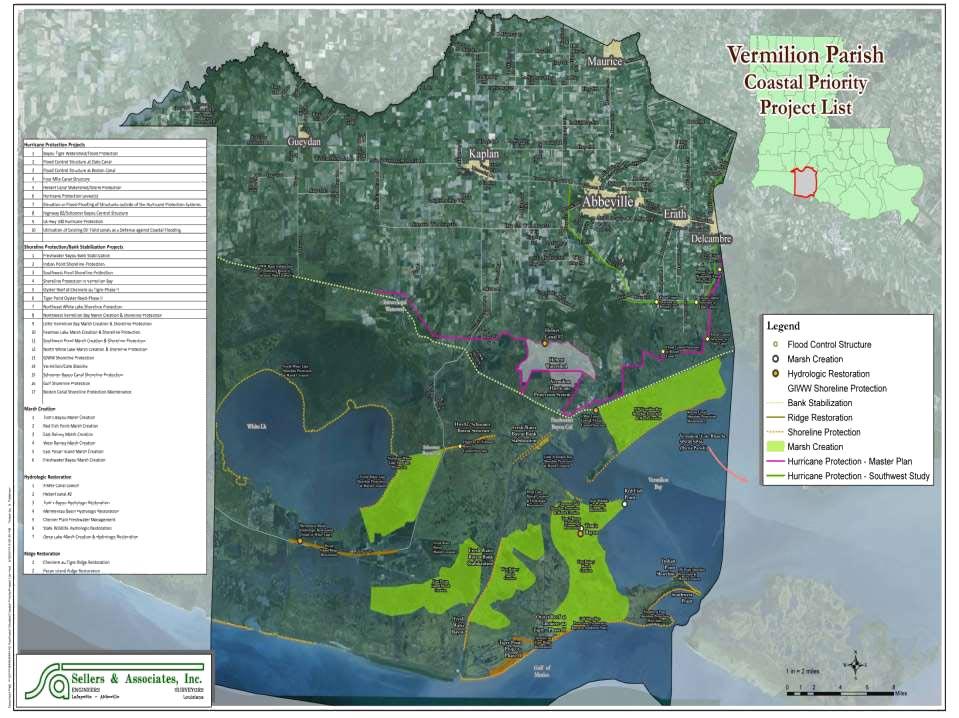
3 Coastal Projects in Vermilion Parish Constructed over the last 26 years (CWPPRA, CIAP, State Surplus) PPL Number Project Name Project Types Current Estimate Acres Benefited 2 ME-04 Freshwater Bayou Wetland Protection Hydrologic Restoration, Shoreline Protection 6,059, ME-13 Freshwater Bayou Bank Stabilization Shoreline Protection 8,913, ME-14 Pecan Island Terracing Sediment and Nutrient Trapping 2,390, ME-22 South White Lake Shoreline Protection Shoreline Protection 14,466, ME-31 Freshwater Bayou Marsh Creation Marsh Creation (E&D cost only) 2,425, TV-03 Vermilion River Cutoff Bank Protection Shoreline Protection 2,047, TV-09 Boston Canal/Vermilion Bay Bank Protection Shoreline Protection, Vegetative Planting 1,043, TV-12 Little Vermilion Bay Sediment Trapping Shoreline Protection, Sediment Trapping 886, TV-16 Cheniere Au Tigre Sediment Trapping Demo Demonstration 624, TV-17 Lake Portage Land Bridge Shoreline Protection 1,181, TV-18 Four Mile Canal Terracing and Sediment Trapping Sediment and Nutrient Trapping 3,792, TV-63 Cole's Bayou Marsh Restoration Hydrologic Restoration, Marsh Creation 26,631, TOTAL CWPPRA FUNDING 70,464, TOTAL CIAP FUNDING 18,361, ME-25 Marsh Creation near Freshwater Bayou TOTAL STATE SURPLUS FUNDING 3,400, VERMILION PARISH GRAND TOTAL 92,225,

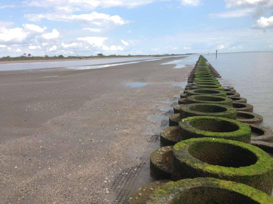
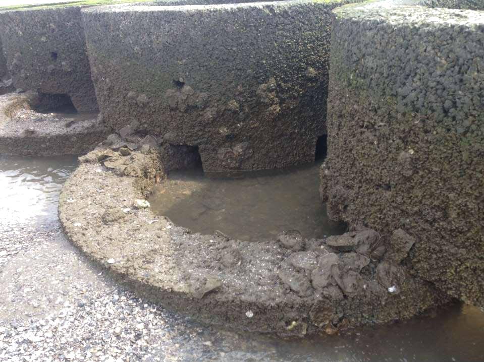
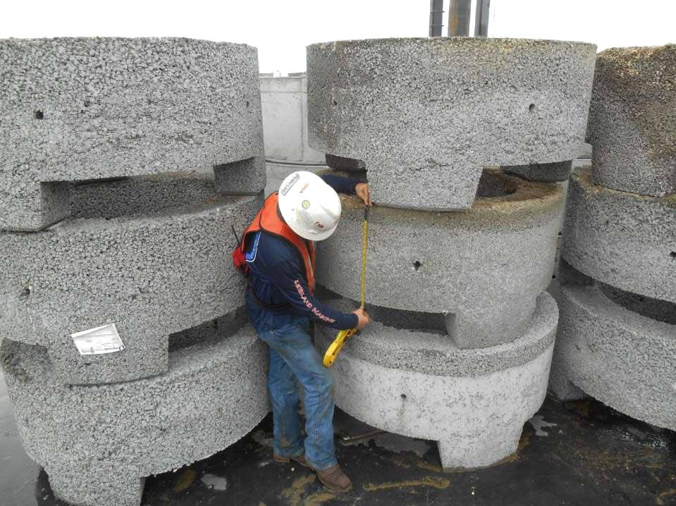
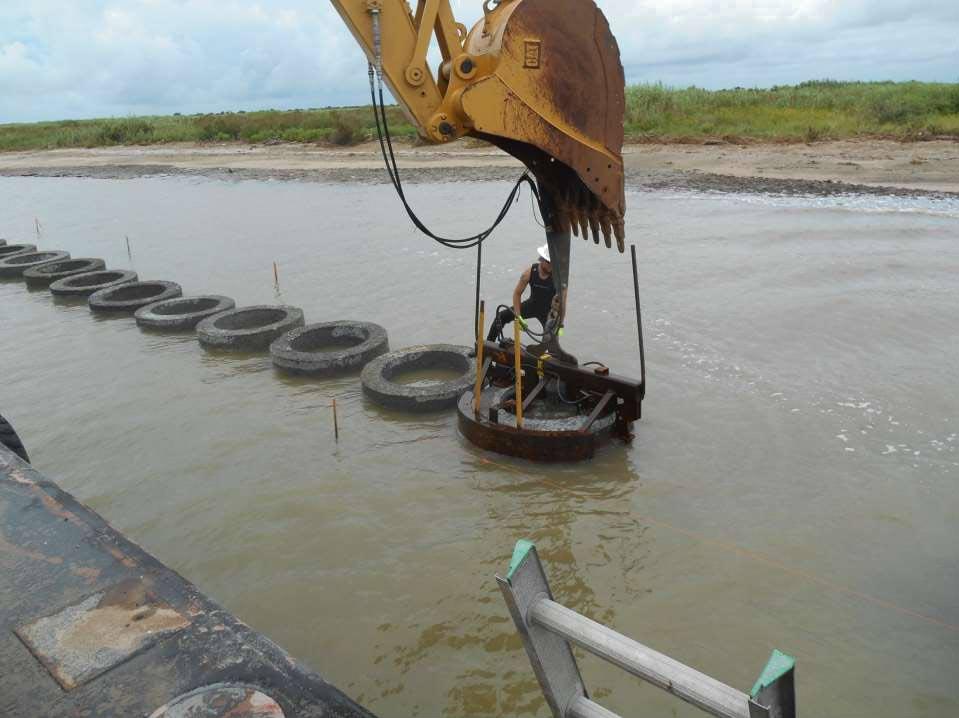
4 OYSTER REEF PARALLEL TO THE COASTLINE AT CHENIERE AU TIGRE PROJECT DESCRIPTION Create a one-half (1/2) mile oyster reef parallel to the shoreline Estimated Cost: $1,438,984 Allocated CIAP Funds: $1,438,984 Status: Construction Complete PROJECT LOCATION


5 OYSTER REEF PARALLEL TO THE COASTLINE AT CHENIERE AU TIGRE


6 OYSTER REEF PARALLEL TO THE COASTLINE AT CHENIERE AU TIGRE
7
8
9
10

11 SHORELINE PROTECTION & MARSH CREATION AT TIGER POINT PROJECT DESCRIPTION Create Oyster Reef Parallel to the Shoreline Allocated CIAP Funds: $1,385,585 Status: Construction Complete PROJECT LOCATION
12
13
14

15 NORTH PRONG OF SCHOONER BAYOU PROJECT DESCRIPTION PROJECT LOCATION Levee restoration on east bank of the North Prong of Schooner Bayou and install culverts with flap gates Estimated Cost: $1,650,000 Allocated CIAP Funds: $1,650,000 Status: Complete

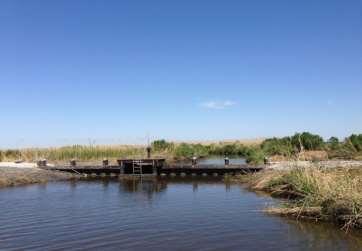

16 Additional Structure Repairs

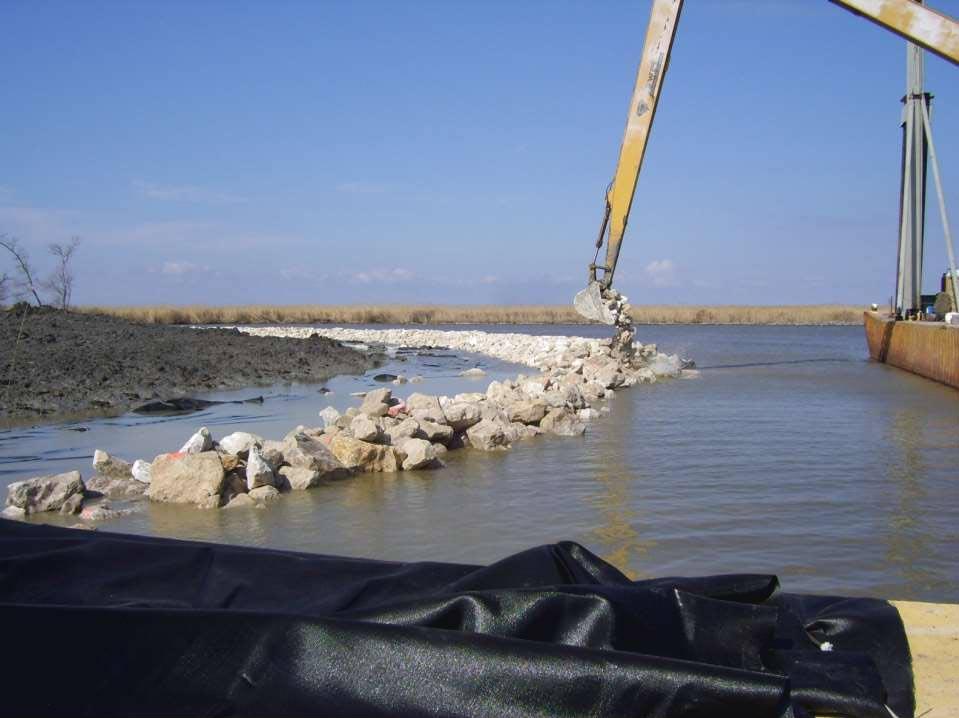
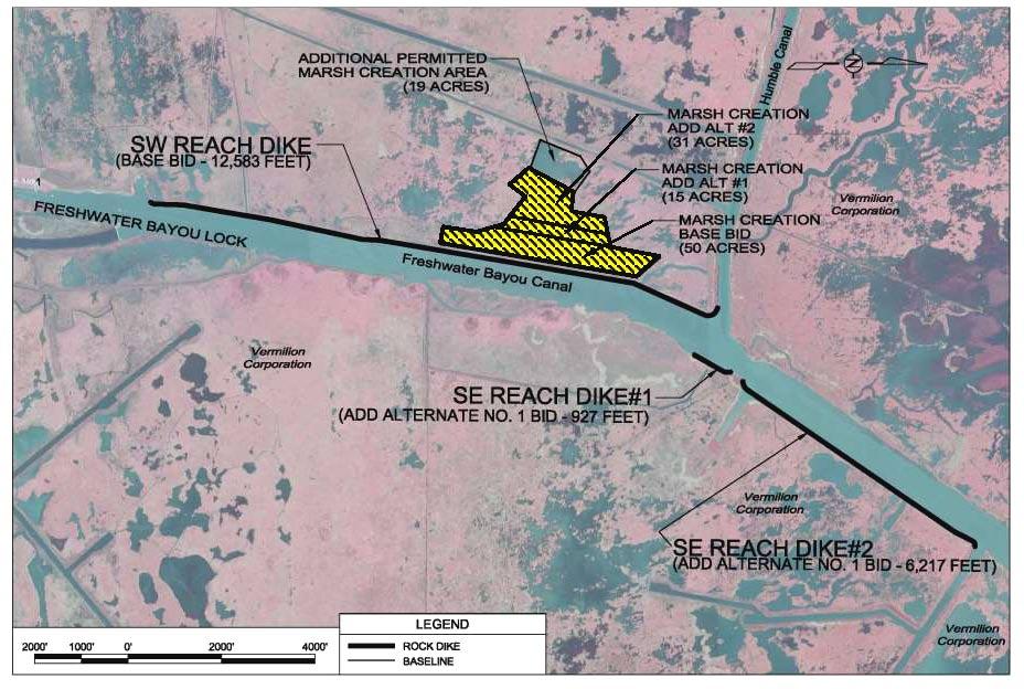
17 FRESHWATER BAYOU BANK STABILIZATION PROJECT DESCRIPTION PROJECT LOCATION Approximately seven (7) miles of rock dike shoreline protection along critical areas of Freshwater Bayou navigation canal Allocated Parish CIAP Funds: $1,568,804 Allocated State CIAP Funds: $12,000,000 Status: Construction Complete
18 INTRACOASTAL CITY VERMILION BAY WHITE LAKE WEST COTE BLANCHE BAY FRESHWATER BAYOU CANAL MARSH ISLAND GULF OF MEXICO

19 INTRACOASTAL CITY Inventory ntory of Freshwater Bayou Bank Stabilization Projects WHITE LAKE ME VERMILION BAY WEST COTE BLANCHE BAY TV ME MARSH ISLAND TV- 11B 1B June 2014 TV- 11B 1B June 2014 GULF OF MEXICO
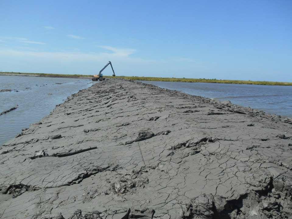
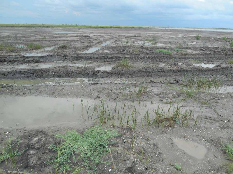
20
21
22
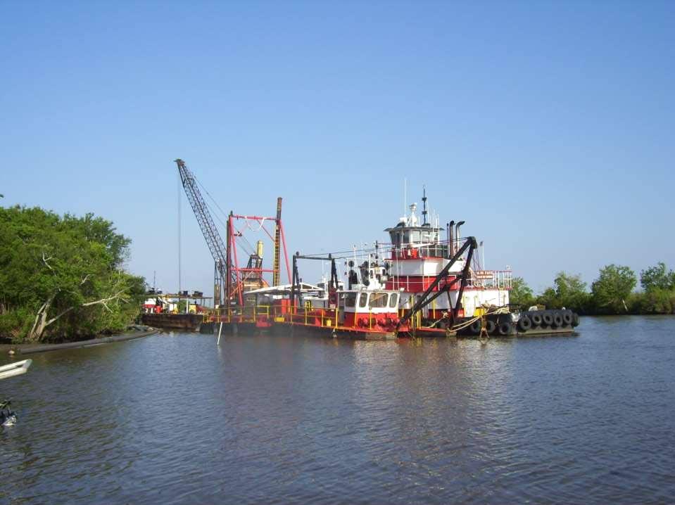
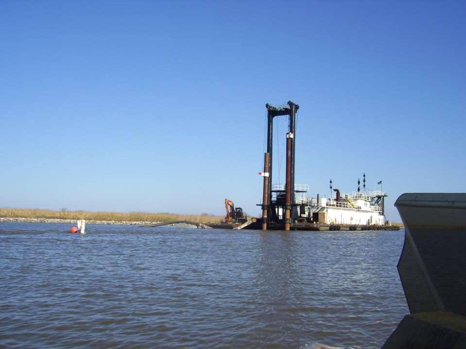
23 FW Bayou Bank Stabilization (ME-04 & ME-13) Maintenance Work Description: Replacement of displaced rock for bank stabilization on western bank of Freshwater Bayou Construction Cost: $4.4 million Funding Source: CWPPRA Status: Construction began: December 2015 Final inspection: March 2016
24 Existing FW Bayou (ME-04 & ME-13) requiring maintenance work
 after")
25 Existing FW Bayou (ME-14 & ME-13) after construction
26 INTRACOASTAL CITY VERMILION BAY WHITE LAKE WEST COTE BLANCHE BAY MARSH CREATION NEAR FRESHWATER BAYOU PROJECT (ME-25) MARSH ISLAND GULF OF MEXICO
27 Marsh Creation near Freshwater Bayou (ME-25) Total Construction Cost: $3.4 million Construction: 96 acres of marsh creation Sediment source: Freshwater Bayou Funding Source: State Surplus Funds (primary source) plus two DNR funds (BU & in lieu fee mitigation) Project Status: Construction started June 18, Dredging complete as of May 22, 2015.
28
29
30
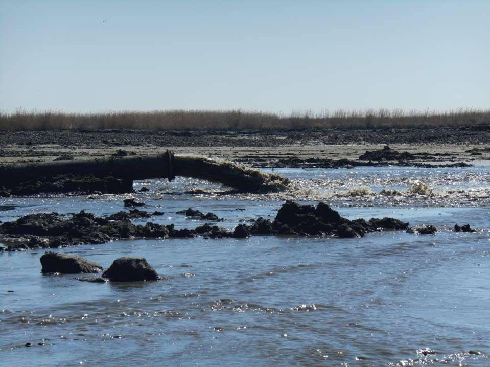
31
32

33
34
35
36
37 INTRACOASTAL CITY VERMILION BAY WHITE LAKE FRESHWATER BAYOU MARSH CREATION PROJECT (ME-31) WEST COTE BLANCHE BAY MARSH ISLAND GULF OF MEXICO
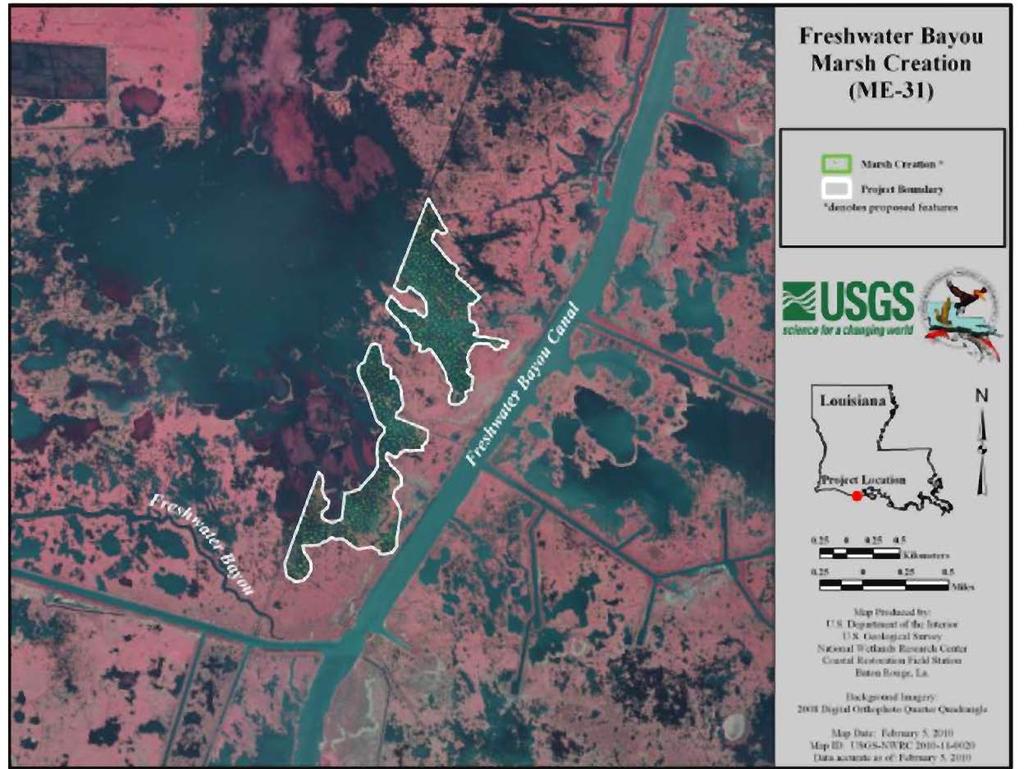
38
39 FW Bayou Marsh Creation (ME-31) Description: Marsh creation west of FW Bayou & north of Humble Canal. Will create 400 acres of marsh with sediment from Gulf of Mexico. Approved funds: $2.4 m (Engineering & Design) Funding Source: CWPPRA Status: Project team identifying pipelines in project footprint Once pipeline identification is complete, final project footprint can be determined. Upon determination of project limits, geotech work and draft landrights to begin. At the earliest, seeking construction funds Dec 2017
40 INTRACOASTAL CITY VERMILION BAY WHITE LAKE COLES BAYOU RESTORATION PROJECT (TV-63) WEST COTE BLANCHE BAY MARSH ISLAND GULF OF MEXICO
41 Funding Source: CWPPRA PPL 21 Federal Sponsor: NMFS Project Information Creates/Nourishes : 418 acres Restores Hydrology thru project area 9 water control structures locations Dredge Volume (cut): 1,828,080 CY Earthen Containment Dikes: 43,108 LF Maximum Pump Distance: 6.1 miles
 jmarsh Creation Area No. 1 (28 ac) Marsh Creation Area No.")
42 Marsh Creation Design Marsh Creation Area No. 2 (108 ac) jmarsh Creation Area No. 1 (28 ac) Marsh Creation Area No. 3 (282 ac) 7/20/
43 Cole s Bayou Restoration (TV-63) Status: Received construction funding approval at January Task Force Meeting Construction permit attained May 2016 Plans and specs are being finalized Project will be bid in 1 st quarter of 2017
44 INTRACOASTAL CITY VERMILION BAY WHITE LAKE LITTLE VERMILION BAY TERRACING (TV-12) WEST COTE BLANCHE BAY MARSH ISLAND GULF OF MEXICO
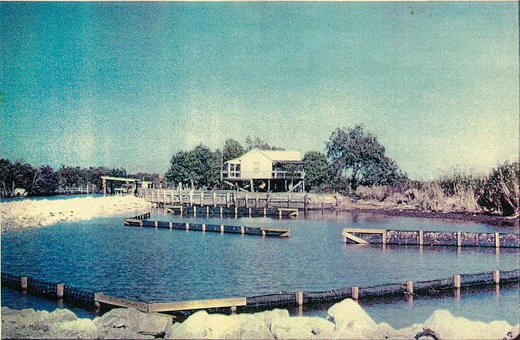
45 LITTLE VERMILION BAY TERRACING PROJECT TV-12 Description: The project consists of dredging 21,300 linear feet of distributary channels and create approximately 33 acres of terraces. The channels and terraces are intended to trap sediments from Freshwater Bayou to create vegetative wetlands and dissipate wave energy in this open water area and combat land loss. Construction Cost: $886,029 (1997) Funding Source: CWPPRA Conclusions and Recommendations as per 2013 CPRA Inspection Report: The Little Vermilion Bay Sediment Trapping Project is in very good condition and still functioning as intended. Emergent vegetation is becoming established. Narrowing the opening into FWB and reestablishing the sacrificial terraces to the south will allow this project to continue to be successful.
46 INTRACOASTAL CITY WHITE LAKE Vermilion River VERMILION Cutoff BAY (Four Mile Canal) WEST COTE BLANCHE BAY MARSH ISLAND GULF OF MEXICO
47 INTRACOASTAL CITY WHITE LAKE Vermilion River Cutoff Bank Protection (TV-03) VERMILION BAY WEST COTE BLANCHE BAY MARSH ISLAND GULF OF MEXICO
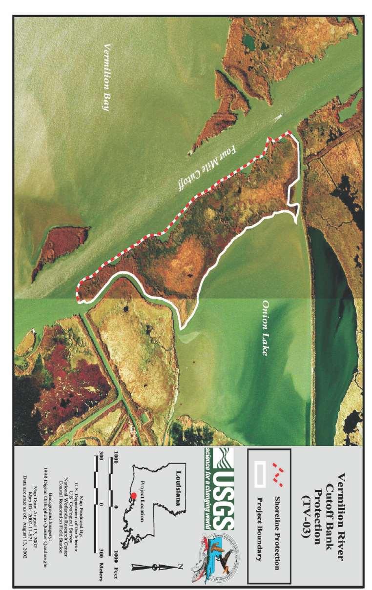
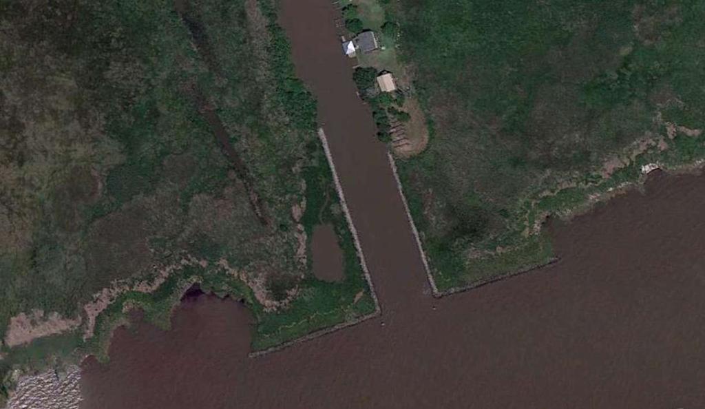
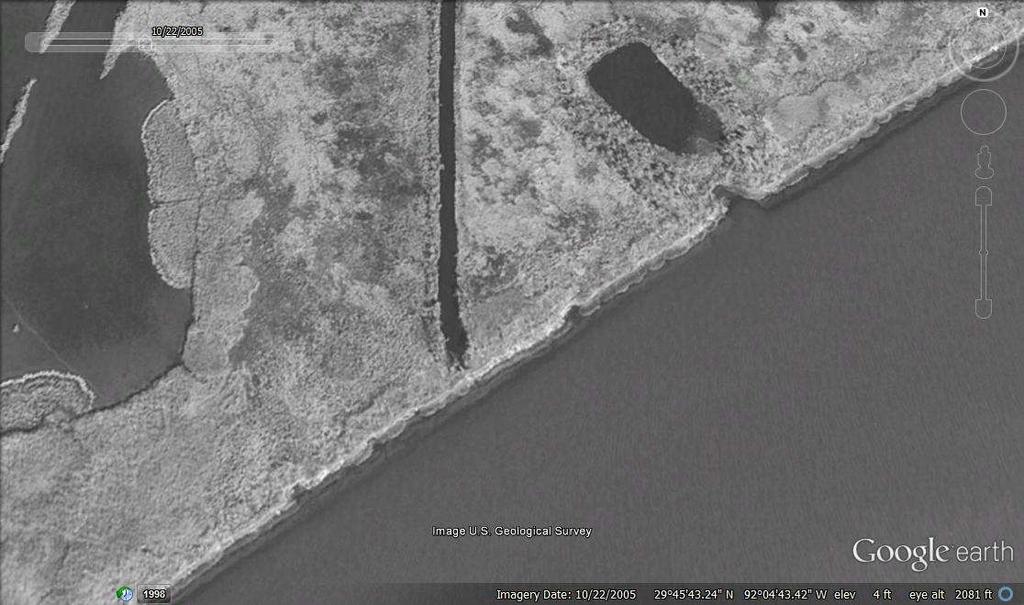
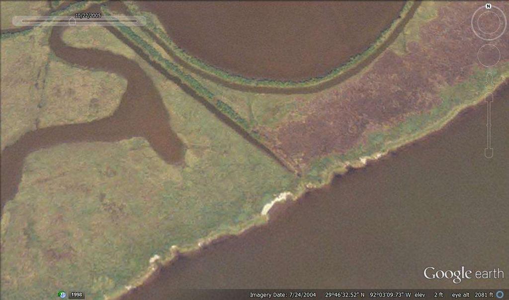
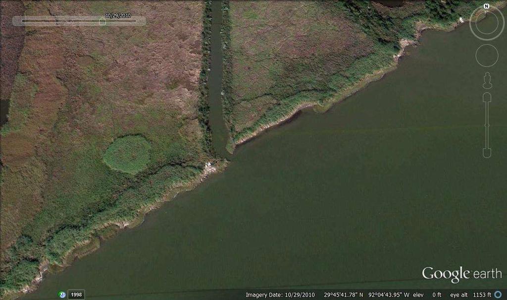
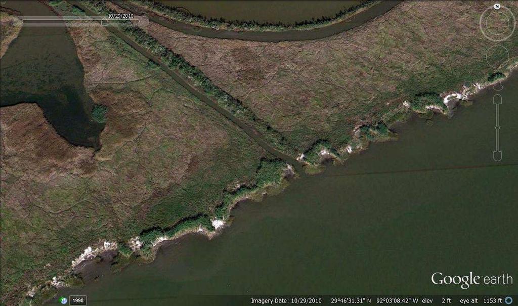
48 Vermilion River Cutoff Bank Protection Funding Source: CWPPRA Federal Sponsor: USACE Project Cost: $2,047,479 Protects : 194 acres Foreshore Rock Dike: 8,900 LF Status: Construction complete
49 49
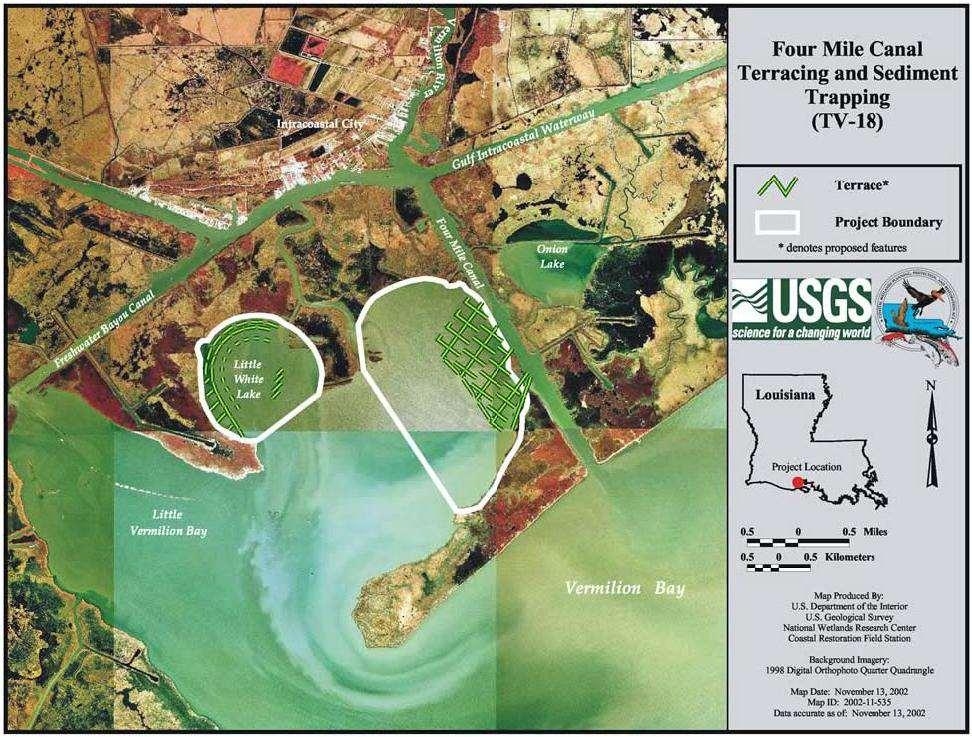
50 INTRACOASTAL CITY WHITE LAKE FOUR MILE TERRACING & SEDIMENT TRAPPING (TV-18) VERMILION BAY WEST COTE BLANCHE BAY MARSH ISLAND GULF OF MEXICO
51 Project Information Funding Source: CWPPRA Federal Sponsor: NMFS Project Cost: $3,792,936 Creates: 214 acres Protects : 113 acres in Vermilion Bay Earthen Terraces: 50,000 LF Status: Construction complete
52 52
53 INTRACOASTAL CITY Boston Canal Shoreline Protection (TV-09) WHITE LAKE VERMILION BAY WEST COTE BLANCHE BAY MARSH ISLAND GULF OF MEXICO

54 Project Information Project: Boston Canal/Vermilion Bay Bank Protection (TV-09) Place map and/or project photos here Construction Date: November 1995 Project Purpose: Stabilize 15 miles of the northern bank of Vermilion Bay shoreline and prevent further regression of the Boston Canal banks Project Features: 1,405 LF of Rock Riprap Dikes Miles of Vegetative Shoreline Plantings
55 55
56 56
57 Proposed Future Restoration and Protection Projects Breaches along norther rim of Vermilion Bay Bayou Tigre Flood Protection Projects 57
58 INTRACOASTAL CITY WHITE LAKE EAST & WEST BREACHES ON VERMILION BAY RIM VERMILION BAY WEST COTE BLANCHE BAY MARSH ISLAND GULF OF MEXICO
59 Project Information Breaches have occurred over the years and have formed a connection with the Vermilion Bay and the interior marshes The proposed project plans to plug the breaches and restore the natural hydrology Funding for the project will come from the RESTORE Act (BP Settlement) 59
60 60
61 61
62 62
63 63
64 Bayou Tigre Flood Control (TV-57) INTRACOASTAL CITY VERMILION BAY WHITE LAKE WEST COTE BLANCHE BAY MARSH ISLAND GULF OF MEXICO

65
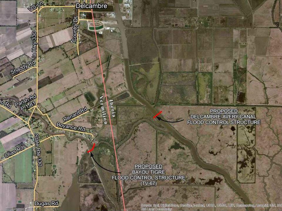
66
67
68
69
70
71
72
73

74 Franklin Canal Barge Gate Constructed 2014 (Bayou Tigre Gate will be similar type structure)
75 Bayou Tigre Flood Control Project (TV-57) Proposed Construction : Barge Gate; levee work Funding Source: CDBG funds Location: SE of Erath; S of Delcambre; West of Delcambre/Avery Canal; 9 miles N of Vermilion Bay Project Status: Design of structure and pump station on hold pending outcome of meeting with FEMA regarding level of detail of H&H study with regards to No Rise Certification.


76 Questions? Contact Vermilion Parish Protection and Restoration Committee
Riverine Sand Mining/Scofield Island Restoration (BA-40)
") Riverine Sand Mining/Scofield Island Restoration (BA-40) Conference on Ecological and Ecosystem Restoration Kenneth Bahlinger, CPRA Project Manager July 31, 2014 committed to our coast committed to our
Riverine Sand Mining/Scofield Island Restoration (BA-40) Conference on Ecological and Ecosystem Restoration Kenneth Bahlinger, CPRA Project Manager July 31, 2014 committed to our coast committed to our
USACE GALVESTON DISTRICT PROJECT UPDATE
 USACE GALVESTON DISTRICT PROJECT UPDATE 255 255 255 237 237 237 0 0 0 217 217 217 163 163 163 200 200 200 DREDGE YOUR DOCKS 2018 131 132 122 239 65 53 80 119 27 110 135 120 252 174.59 112 92 56 62 102
SAME/SBA CONFERENCE. Col. Christopher W. Sallese Commander, Galveston District U.S. Army Corps of Engineers April 11, 2012
 SAME/A CONFERENCE Col. Christopher W. Sallese Commander, Galveston District U.S. Army Corps of Engineers April 11, 2012 U.S. Army Corps of Engineers Galveston District BUILDING STRONG 1 History of the
BENEFICIAL USE OF DREDGED MATERIAL DISPOSAL HISTORY HOUMA NAVIGATION CANAL, LA
 BENEFICIAL USE OF DREDGED MATERIAL DISPOSAL HISTORY HOUMA NAVIGATION CANAL, LA 1991-2012 The Houma Navigation Canal (HNC) provides a navigation channel between Houma, Louisiana, and the Gulf of Mexico
Appendix C. Past and Current Management of Selected Tidal Wetland Sites
 Appendix C. Past and Current Management of Selected Tidal Wetland Sites Maps and photographs of wetland sites can be found at http://www.elkhornslough.org/tidalwetlandproject. Site 1. Parsons Slough/South
TEXAS PORTS Value to the Nation
 TEXAS PORTS Value to the Nation Col. Christopher W. Sallese District Commander, Galveston District U.S. Army Corps of Engineers March 18, 2013 Houston-Galveston Area Council US Army Corps of Engineers
Galveston Bay Estuary Program. Carla G. Guthrie, Ph.D. Galveston Bay Council Member Texas Water Development Board
 Galveston Bay Estuary Program Carla G. Guthrie, Ph.D. Galveston Bay Council Member Texas Water Development Board The statements contained in this presentation are my current views and opinions and are
2012 Texas Water Conservation Association Meeting
 2012 Texas Water Conservation Association Meeting BG Thomas Kula Southwestern Division Commander 15 June 2012 US Army Corps of Engineers AGENDA UNCLASSIFIED Overview of Southwestern Division Missions Texas
Engineering With Nature Geographic Project Mapping Tool (EWN ProMap)
") Engineering With Nature Geographic Project Mapping Tool (EWN ProMap) Cynthia Banks Program Manager Burton Suedel, PhD Research Biologist Michelle Bourne Research Biologist U.S. Army ERDC 23 June 2015 Dredging
Engineering With Nature Geographic Project Mapping Tool (EWN ProMap) Cynthia Banks Program Manager Burton Suedel, PhD Research Biologist Michelle Bourne Research Biologist U.S. Army ERDC 23 June 2015 Dredging
GALVESTON DISTRICT Dredging Schedules
 GALVESTON DISTRICT Dredging Schedules Christopher Frabotta Chief, Navigation Branch Southwestern Division - Galveston District November 2, 2016 Galveston District Dredging Meeting Custodians of the Texas
Recreational Impacts of Coastal Restoration Projects in Louisiana
 Recreational Impacts of Coastal Restoration Projects in Louisiana i National Conference on Ecosystem Restoration Baltimore, MD Joseph Berlin and Andrew Perez August 5, 2011 Recreational Impacts were Estimated
Presented to: City of Petaluma City Council
 Agenda Item #1.A REVISED Presented to: City of Petaluma City Council Presented By: Dan St. John, F.ASCE, Director Jason Beatty, P.E., Senior Engineer James 'Jody' Boyette, USACE Project Manager November
Paper 1F and 3H: Decision-Making Exercise. Wednesday 4 June 2008 Morning Resource Booklet. Advance Information
 Paper Reference(s) 1313/1F and 3H Edexcel GCSE Geography B Paper 1F and 3H: Decision-Making Exercise Wednesday 4 June 2008 Morning Resource Booklet Advance Information Do not open before Wednesday 30 April
St. Augustine Port, Waterway & Beach District. St. Augustine Inlet 2013 draft Inlet Management Plan. March 19, 2013
 Division of Water Resource Management St. Augustine Port, Waterway & Beach District St. Augustine Inlet 2013 draft Inlet Management Plan March 19, 2013 Discussion Outline Florida Statutes Florida Inlets
2. The EPA provided the following information regarding EPA s activities in Newark Bay during the meeting:
 CENAN-PP-C 10 September 2013 MEMORANDUM FOR RECORD SUBJECT: Newark Bay Study Area Coordination Team Meeting 1. The regularly scheduled monthly interagency coordination meeting was held on September 10
March 2, The Honorable Mayor Williams D. Sessoms, Jr. Members of City Council. Subject: Coastal CIP Presentation to City Council - March 6, 2018
 OFFICE OF THE CITY MANAGER (757) 385-4242 (757) 427-5626 FAX MUNICIPAL CENTER BUILDING 1, ROOM 234 2401 COURTHOUSE DRIVE VIRGINIA BEACH, VA 23456-9001 March 2, 2018 The Honorable Mayor Williams D. Sessoms,
Striving for resilience in the face of climate change
 Striving for resilience in the face of climate change Three years and eight months have elapsed since the country suffered one of its worst flooding events, affecting a couple of districts mainly in east-south
Buffalo District Navigation Program Overview
 Buffalo District Navigation Program Overview 16 FEB 2011 US Army Corps of Engineers Buffalo District Area of Operations Our Facilities District Headquarters 2 Area Offices 3 Regulatory Field Offices Lake
HARBOR INFRASTRUCTURE INVENTORIES Erie Harbor, PA
 HARBOR INFRASTRUCTURE INVENTORIES Erie Harbor, PA Harbor Location: Erie Harbor is located on the southern shore of Lake Erie in the City of Erie, PA about 98 Miles southwest of Buffalo. Authority: River
Principle Causes of Dam Failures. Structural failure. Cracking. Stability failure. BIA Summer Water Resources Training Dam Safety Inspections
 BIA Summer Water Resources Training Dam Safety Inspections Principle Causes of Dam Failures Part 2 Dam Failures July 28, 2012 Presented by Michael Johnson, Ph.D., P.E. Overtopping Structural failure Stability
SUBJECT: Newark Bay Study Area Coordination Team Meeting, 9 October 2012
 CENAN-PP-H 9 Oct 12 MEMORANDUM FOR RECORD SUBJECT: Newark Bay Study Area Coordination Team Meeting, 9 October 2012 1. The regularly scheduled monthly interagency coordination meeting was held on 9 Oct
DREDGED MATERIAL DISPOSAL HISTORY AVOCA ISLAND LAKE
 DREDGED MATERIAL DISPOSAL HISTORY AVOCA ISLAND LAKE The Atchafalaya River & Bayous Chene, Boeuf, & Black, Louisiana, project was authorized by the Rivers and Harbors Act of 1968, House Document 155, 90
Impact of Offshore Directed Forcing on Sediment Transport and Structural Integrity at Packery Channel, Corpus Christi Texas
 Google Earth 29 Aug 2017 Impact of Offshore Directed Forcing on Sediment Transport and Structural Integrity at Packery Channel, Corpus Christi Texas Deidre D. Williams Coastal Research Scientist Conrad
TRINITY RIVER CORRIDOR
 TRINITY RIVER CORRIDOR MODIFIED DALLAS FLOODWAY PROJECT UPDATE May 12, 2015 Jon Loxley Project Manager Dallas Floodway Project Fort Worth District U.S. Army Corps of Engineers US Army Corps of Engineers
BENEFICIAL USE OF DREDGED MATERIAL PILOT PROGRAM
 SECTION 1122 OF WRDA 2016 1 BENEFICIAL USE OF DREDGED MATERIAL PILOT PROGRAM National Dredging Meeting June 13, 2018 The views, opinions and findings contained in this report are those of the authors(s)
Stakeholder Meeting #1. An Introduction to the Blind Pass Inlet Management Study
 Stakeholder Meeting #1 An Introduction to the Blind Pass Inlet Management Study April 21, 2016 5:30 PM, The Sanctuary, Sanibel Island A World of Solutions 0 Agenda Introductions Study Overview Study Status
Cat Island Chain Background & Access Guide
 Cat Chain Background & Access Guide Brown County Port & Resource Recovery Department 2561 S. Broadway, Green Bay, WI 54304 (920) 492-4950 www.portofgreenbay.com January 2018 1 Restoration of the Cat Chain
WHY THERE IS NO STORM SURGE PROTECTION FOR THE LAKE PONTCHARTRAIN BASIN
 WHY THERE IS NO STORM SURGE PROTECTION FOR THE LAKE PONTCHARTRAIN BASIN A Report Addressing: I. The Reason Why The Corps Of Engineers Abandoned Its Plan To Keep Storm Surge Out Of The Lake Pontchartrain
Statistical Evaluation of BMP Effectiveness in Reducing Fecal Coliform Impairment in Mermentau River Basin
 Statistical Evaluation of BMP Effectiveness in Reducing Fecal Coliform Impairment in Mermentau River Basin Z.-Q. Deng 1 and H. Chowdhary 2 1 Assistant Professor, Department of Civil and Environmental Engineering,
Cleveland Harbor Dredged Material Management
 Cleveland Harbor Dredged Material Management Requirements, Capacity Issues, and Placement Alternatives Brent R. Leslie, CPA Chief Financial Officer Cleveland-Cuyahoga County Port Authority Brent.Leslie@portofcleveland.com
KASKASKIA RIVER NAVIGATION POOL Compartment 12 UNIT 1 Kaskaskia Lock and Dam Lands These lands are now being managed by the Carlyle Lake project
 KASKASKIA RIVER NAVIGATION POOL Compartment 12 UNIT 1 Kaskaskia Lock and Dam Lands These lands are now being managed by the Carlyle Lake project office. Sections 1-4 in this plan present Kaskaskia River
THE LEVEES OF DALLAS COUNTY
 THE LEVEES OF DALLAS COUNTY Jessica Baker, EIT, CFM Walter Skipwith, P.E. Steve Parker, P.E., CFM TFMA 2008 Spring Conference League City, TX May 1, 2008 Introduction Map Modernization Program Certification
4.0 Context for the Crossing Project
 4.0 Context for the Crossing Project This section provides background information about key features of the North Douglas Crossing project area, and opportunities and constraints. This information is important
Appendix 4 St. Charles Basin
 Appendix 4 St. Charles Basin The St. Charles hurricane protection system (HPS), shown in Figure 1, was designed as part of the Lake Pontchartrain, LA, and Vicinity Hurricane Protection Project. The St.
PORT EVERGLADES SAND BYPASS PROJECT
 28 th Annual National Conference on Beach Preservation Technology February 4, 2015 Clearwater Beach, FL PORT EVERGLADES SAND BYPASS PROJECT AN IMPORTANT FUTURE SAND SOURCE FOR SOUTHEAST FLORIDA BEACHES
Speculative Investment in the Mississippi Delta of the Future
 Speculative Investment in the Mississippi Delta of the Future Introduction This report analyzes future scenarios of Southern Louisiana based on the events surrounding Hurricane Katrina and the possibility
Proposed Cherry Grove Canals Dredging Project
 Proposed Cherry Grove Canals Dredging Project 1 Development of Cherry Grove C.D. Nixon inherited 9,940 acres of land 1924 Nixon family began planning subdivision of Cherry Grove 1950 Mr. Nixon closed natural
Norfolk District North Atlantic Division
 Norfolk District North Atlantic Division Eastern Chapter of WEDA Fall Conference October 9, 2012 Stephen J. Powell, P.E. (757) 201-7788 US Army Corps of Engineers 5-Year Dredging Schedule (By dredge type)
2017 and Beyond Forecasted Acquisition Strategy- Jacksonville District Updated 17 Mar 2017
 and Beyond Forecasted Acquisition Strategy- Jacksonville District Updated 17 Mar DISCLAIMER: The forecast data is for planning purposes, does not represent a presolicitation synopsis, does not constitute
Phoenix Habitat Restoration Projects
 Phoenix Habitat Restoration Projects Spur Cross Ranch Cave Creek (Estergard) Regional Tree and Shade Summit March 9, 2010 Desert Riparian Ecosystems Healthy riparian areas like this once existed along
Great Lakes Waterways Conference
 Great Lakes Waterways Conference David Wright U.S. Army Corps of Engineers Chief of Operations Detroit District US Army Corps of Engineers Agenda FY14 Maintenance Dredging Key FY14 Needs/Projects Duluth-Superior
Ongoing Projects 3/16/2017 2
 Ongoing Projects 26 th to 34 th Street, West Avenue to Bay Avenue ($6.5 million contract awarded) 46 th Street (complete) 29 th Street Firehouse South Jersey Gas improvements 34 th Street playground repairs
The Mississippi River Commission. History of the Management of the Mississippi River. US Army Corps of Engineers BUILDING STRONG
 The Mississippi River Commission History of the Management of the Mississippi River US Army Corps of Engineers US Army Corps of Engineers Presentation Outline Overview of Mississippi River History of Mississippi
PUBLIC LIBRARIES IN LOUISIANA Current Status Assessment Hurricane Damage January 6, 2006
 PUBLIC LIBRARIES IN LOUISIANA Current Status Assessment Hurricane Damage January 6, 2006 TOTAL NUMBER OF PUBLIC/PARISH LIBRARY SYSTEMS TOTAL NUMBER OF PARISH/PUBLIC LIBRARY FACILITIES TOTAL NUMBER LIBRARY
CORPS OF ENGINEERS ALASKA DISTRICT Dredging Projects. Michael Tencza, PE Operations Project Manager November 4, 2015
 CORPS OF ENGINEERS ALASKA DISTRICT 2016 Dredging Projects Michael Tencza, PE Operations Project Manager November 4, 2015 US Army Corps of Engineers Building and Preserving Alaska s Future AWARDED CONTRACTS
Waterway Access and the Atlantic Intracoastal Waterway in Florida
 Waterway Access and the Atlantic Intracoastal Waterway in Florida Issues: Maintenance - Funding (costs), Infrastructure needs, permitting Management Consideration of the M-95 system, Cooperation among
Port of Kalama, New Approach to Maintenance Dredging
 Port of Kalama, New Approach to Maintenance Dredging Vladimir Shepsis, Coast @ Harbor Engineering, Inc. John Dawson, Coast @ Harbor Engineering, Inc. Mark Wilson, Port of Kalama Tabitha Reeder, Port of
NEW TECHNOLOGIES AND THEIR IMPACT ON PORT DEVELOPMENT IN JAMAICA. Christopher Hamilton May
 Organization Of American States Second Hemispheric Conference On Inland Ports, Waterways & Dredging NEW TECHNOLOGIES AND THEIR IMPACT ON PORT DEVELOPMENT IN JAMAICA Christopher Hamilton May 18 2017 2.83
Economic Impacts of Beach Nourishment in Texas
 Galveston Island South Padre Island April 25, 2017 Economic Impacts of Beach Nourishment in Texas Michael Walther Coastal Tech G.E.C., Inc. Reuben Trevino - Galveston Island Park Board of Trustees Special
Pump Stations...more than just pumps
 Task Force Hope Status Report Newsletter March 13, 2013 Pump Stations...more than just pumps Photo by Jerry Baggett Pump Station 11, Algiers Canal Repairs and Fronting Protection Repaired pump stations
NC Dredge Studies NCBIWA Spring Conference April 23, 2018
 NC Dredge Studies Study of the Use and Efficiency of the Dredge Manteo Study of Acquisition of Dedicated Dredging Capacity Study of Dredging Services Cost-Benefit Analysis 2018 NCBIWA Spring Conference
30 November Randall G. Hintz Chief, Operations Support Branch Operations Division. US Army Corps of Engineers BUILDING STRONG
 30 November 2011 Randall G. Hintz Chief, Operations Support Branch Operations Division US Army Corps of Engineers Overview MAINTENANCE PROJECTS Deep Draft Channels Shallow Draft Channels Coastal Inlets
Figure 7. Dragline at Cape Coral, Figure 8. Cape Coral oblique aerial photograph, 1959.
 The dredge-and-fill method, which would later be criticized for its environmental impact, employed in the peak years of the early 1960s as many as four dredges and ten draglines, which at times operated
HARBOR INFRASTRUCTURE INVENTORIES Cleveland Harbor, OH
 HARBOR INFRASTRUCTURE INVENTORIES Cleveland Harbor, OH Harbor Location: Cleveland Harbor is located at the mouth of the Cuyahoga River on the southern shore of Lake Erie in the city of Cleveland, OH. Authority:
Great Lakes Navigation System Dredging Update
 Great Lakes Navigation System Dredging Update Marie Strum U.S. Army Corps of Engineers Great Lakes Navigation Team June 3, 2015 US Army Corps of Engineers Great Lakes Dredging Team Annual Meeting Great
MANAGING COASTAL HAZARDS THROUGH BENEFICIAL REUSE OF DREDGED SAND AND AN ADAPTIVE WORKS STRATEGY
 MANAGING COASTAL HAZARDS THROUGH BENEFICIAL REUSE OF DREDGED SAND AND AN ADAPTIVE WORKS STRATEGY Isabelle Ghetti 1, B.Morgan 2, R.Massie 1, Gary Blumberg 2 1 Shoalhaven City Council, Nowra, NSW 2 Royal
Mississippi River & Tributaries Project History & Overview
 Mississippi River & Tributaries Project History & Overview Watershed Division Mississippi Valley Division 17 June 2015 US Army Corps of Engineers BUILDING STRONG Lake Texoma Spillway Tulsa Little Rock
Pinellas County Environmental Lands
 Pinellas County Environmental Lands In addition to traditional parks and recreation facilities, Pinellas County owns and manages a system of environmental lands that provides specialized resource-based
The History & Management of the Atlantic Intracoastal Waterway in Florida
 The History & Management of the Atlantic Intracoastal Waterway in Florida THE BEGINNING OF THE INTRACOASTAL WATERWAY IN FLORIDA CONSTRUCTED BY A PRIVATE COMPANY, THE FLORIDA EAST COAST CANAL COMPANY BETWEEN
Edisto Beach Renourishment and Groin Lengthening Project. Tim Kana Coastal Science & Engineering
 Edisto Beach Renourishment and Groin Lengthening Project Tim Kana Coastal Science & Engineering Hurricane Matthew 8 Oct 2016 Cat 1 Storm @ Edisto Beach Worst Surge Event Since DAVID in 1979 Tides ~ 5 ft
Great Lakes Navigation System Buffalo District
 Great Lakes Navigation System Buffalo District Josh Feldmann U.S. Army Corps of Engineers Chief, Operations Branch 9 FEB 2016 US Army Corps of Engineers BUILDING STRONG Key FY16/17 Buffalo District O&M
Sulphur Creek Wetlands Restoration Project in the Valles Caldera National Preserve, Sandoval County, New Mexico
 DA Number Action Type Project Name Closure Method County State SPA-2015-00107-ABQ Sulphur Creek Wetlands Restoration Project in the Valles Caldera National Preserve, Sandoval County, New Mexico Sandoval
The Use of Low Cost Breakwaters for Mangrove Restoration in Muddy Foreshores
 The Use of Low Cost Breakwaters for Mangrove Restoration in Muddy Foreshores Douglas A. Gaffney, P.E. Ranata Robertson October 23, 2012 The Use of Low Cost Breakwaters for Mangrove Restoration in Muddy
NC Dredge Studies. Sterling Baker, P.E. NCDOT James Gregson NCDEQ April 5, 2018
 NC Dredge Studies Study of the Use and Efficiency of the Dredge Manteo Study of Acquisition of Dedicated Dredging Capacity Study of Dredging Services Cost-Benefit Analysis Sterling Baker, P.E. NCDOT James
-,. II II. t:' -I r~ Hor~~on~?~ Environmental Services, Inc. - ~'-""~?>'"'~ .G~\\ \<:--s Po?> I~- Gulf of Mexico FIGURE 1. 2 Legend l:=i Project Area
 SWG-28-352 MODIFICAION REQUEST Page 1 of 26 USACE RECEIVED DATE: 1 AUG18.. 7196/Graphics/IP Figures-Relocated Outfall Structures/7196A1PA_vic.mxd I SBF I 4-15-213 -,. II II I- _J.G\\ \ - '-""?>'"'
Franklin County RESTORE Act Multiyear Implementation Plan. Community Needs Assessment v1.3
 Franklin County RESTORE Act Multiyear Implementation Plan Community Needs Assessment v1.3 Preamble Franklin County is a small coastal community located in northwest Florida and is home to 11,840 residents
Consider approval of minutes for August 8, 2012 regular meeting and August 22, 2012 special meeting
 Posted: September 11, 2012 at 9:20 AM MEETING NOTICE The Regular Monthly Meeting of the Greater Lafourche Port Commission Board of Commissioners will be head in the Conference Room of the Administration
BAYMONT INN & SUITES HOUMA 1254 Grand Caillou Road Houma, LA 70363
 1254 Grand Caillou Road Houma, LA 70363 1 EXECUTIVE SUMMARY VITAL DATA Price $2,500,000 MAJOR EMPLOYERS Down Payment 100% / $2,500,000 Loan Type All Cash Price/Room $37,879 Ownership Type Fee Simple Number
October 7, 2016 Hurricane Matthew Rakes the East Coast of Flagler County for 18.1 Miles
 October 7, 2016 Hurricane Matthew Rakes the East Coast of Flagler County for 18.1 Miles Hammock Dunes Suffers Penetration of the Ocean into the Community; has a 15-30 ft. Wide Triangular Section of the
Turning Water Into Land How New Orleans Created the Lakefront Neighborhoods,
 Cityscapes: A Geographer's View of the New Orleans Area Turning Water Into Land How New Orleans Created the Lakefront Neighborhoods, 1926-1934 Richard Campanella Published in the New Orleans Times-Picayune,
Survey of Rodman Reservoir and middle-ocklawaha River springs during spring 2008 draw-down conditions: FWC and FWS
 Survey of Rodman Reservoir and middle-ocklawaha River springs during spring 2008 draw-down conditions: FWC and FWS Date of Survey: February 26, 2008 Survey conducted by: Dawn Jennings, USFWS Nicole Adimey,
Norfolk District North Atlantic Division
 Norfolk District North Atlantic Division Eastern Chapter of WEDA Fall Conference October 26, 2016 Stephen J. Powell, P.E. (757) 201-7788 US Army Corps of Engineers Norfolk District FY-17 Dredging Program
CHAPTER III: TRAIL DESIGN STANDARDS, SPECIFICATIONS & PERMITS
 CHAPTER III Trail Design Standards, Specifications & Permits This chapter discusses trail standards, preferred surface types for different activities, permits, and other requirements one must consider
The Corps of Engineers Dredges on the West Coast
 The Corps of Engineers Dredges on the West Coast Presented To California Marine Affairs and Navigation Conference Sheryl Carrubba Operations Manager, Channels & Harbors Portland District November 8, 2011
Ecosystem context in the Environmental Impact Assessment of the Dredging Operations in the Argentina s Santa Fe
 Ecosystem context in the Environmental Impact Assessment of the Dredging g Operations in the Argentina s Santa Fe Confluencia Waterway (Paraná River) Authors: Claudio Daniele (Estudio de Ambiente y Desarrollo
Introduction and Company Overview
 Introduction and Company Overview Multi-discipline consulting firm Founded in 1950 - HQ in Laurel, Maryland Local WPB Office Survey, Utility Coordination, Roadway Design, Environmental and CEI Past Port
MOBILE DISTRICT 2018 DREDGING PROGRAM
 MOBILE DISTRICT 2018 DREDGING PROGRAM SOUTH ATLANTIC DIVISION U.S. ARMY CORPS OF ENGINEERS Trusted Partners Delivering Value Today for a Better Tomorrow US Army Corps of Engineers BUILDING STRONG MOBILE
Waterways Council November 10, 2017
 Waterways Council November 10, 2017 MULTI-PURPOSE LANDLORD PORT The Port of New Orleans generates its own revenues as a multipurpose landlord port. Cargo 69%; cruise 21%; real estate 10% Diversity increases
CARIBBEAN FOOD CROPS SOCIETY
 CARIBBEAN FOOD CROPS SOCIETY SERVING THE CARIBBEAN SINCE 1963 CARIBBEAN FOOD CROPS SOCIETY 47 Forty-Seventh Annual Meeting 2011 Bridgetown, Barbados Volume XLVII - Number 1 T-STAR Invasive Species Symposium
MARINE PROTECTED AREAS LESSON PLAN Water Parks
 Marine Protected Areas U. S. Marine Protected Areas Lesson Plan MARINE PROTECTED AREAS LESSON PLAN Water Parks Theme U.S. Marine Protected Areas Links to Overview Essays and Resources Needed for Student
Mr. Jeff Keever Deputy Executive Director Virginia Port Authority May 2, 2012
 Management of Dredged Materials: Challenges and Opportunities Mr. Jeff Keever Deputy Executive Director Virginia Port Authority May 2, 2012 1 Craney Island Eastward Expansion and Marine Terminal NNMT Hampton
MEXICO CITY S NEW INTERNATIONAL AIRPORT 2017 ACI-LAC Conference. November 2017
 MEXICO CITY S NEW INTERNATIONAL AIRPORT 2017 ACI-LAC Conference November 2017 Millions of Passengers The need for a new airport» New Airport opening in 2020 Passenger Projections Growth: 140 120 100 80
SAN ANTONIO RIVER IMPROVEMENTS PROJECT. August 6, 2008
 SAN ANTONIO RIVER IMPROVEMENTS PROJECT August 6, 2008 1 History of the SA River Improvements 1921 Flood Olmos Dam Complete in 1929 Downtown Flood Relief Projects in 1950 s Dams on the River Channel and
Restoring Great Waters & National Parks for the 2nd Century of the National Park System: A National Overview
 Restoring Great Waters & National Parks for the 2nd Century of the National Park System: A National Overview John Adornato Conference on Ecological and Ecosystem Restoration New Orleans July 29, 2014 National
^ox, 7. Environment Agency. Hayling Island North Strategy *. M ^, v. * > -.
 ^ox, 7 Environment Agency Hayling Island North Strategy *. M ^, v. * > -. Consultation Document for Preferred Coastal Defence Options - Septem ber 2005 We are the Environment Agency. It s our job to look
LAUNCH OF THE COASTAL ZONE MANAGEMENT TRUST
 A 60km stretch of coastline on the Yucatan Peninsula of Mexico is the testing ground for an idea that could protect fragile environments around the world: insuring coral reefs. The Economist World Ocean
Florida Department of Environmental Protection Division of Recreation and Parks
 Florida Department of Environmental Protection Division of Recreation and Parks Land Honeymoon Island State Park Introduction Honeymoon Island State Park is a 2,810.16-acre public outdoor recreation and
2011 Nags Head Beach Nourishment Project Update. Tim Kana & Haiqing Kaczkowski
 2011 Nags Head Beach Nourishment Project Update Tim Kana & Haiqing Kaczkowski NCBIWA Conference 3 April 2017 Outline of the Presentation 1 Review 2011 Nourishment Project Post-project monitoring efforts
Coastal Management: Treasure Island - Long Key Nourishment
 Coastal Management: Treasure Island - Long Key Nourishment Project Completed - October 20, 2010 The nourishment of Treasure Island and Long Key (TI/LK) beaches began in late July of 2010. The previous
HARBOR INFRASTRUCTURE INVENTORIES Buffalo Harbor, New York
 HARBOR INFRASTRUCTURE INVENTORIES Buffalo Harbor, New York Harbor Location: Buffalo Harbor is located on the Eastern shore of Lake Erie in the City of Buffalo, NY. Authority: River & Harbor Acts of 1826,
Sandbag Barrier. Suitable Applications Sandbag barriers may be suitable: As a linear sediment control measure:
 Categories EC Erosion Control SE Sediment Control TC Tracking Control WE Wind Erosion Control Non-Stormwater NS Management Control Waste Management and WM Materials Pollution Control Legend: Primary Category
Great Lakes Navigation System Buffalo District
 Great Lakes Navigation System Buffalo District Josh Feldmann U.S. Army Corps of Engineers Chief, Operations Branch Feb 12, 2013 US Army Corps of Engineers Key FY13 Buffalo District O&M Activities i i Dredging
Mt. Hood National Forest
 United States Department of Agriculture Forest Service Mt. Hood National Forest Zigzag Ranger District 70220 E. Highway 26 Zigzag, OR 97049 503-622-3191 Fax: 503-622-5622 File Code: 1950-1 Date: June 29,
Table of Contents. Overview Objectives Key Issues Process...1-3
 Table of Contents Chapter One Introduction Overview...1-1 Objectives...1-1 Key Issues...1-2 Process...1-3 Chapter Two Inventory of Existing Conditions Airport Setting...2-1 Locale...2-1 Airport Surroundings...2-5
On the Edge with Mangroves
 On the Edge with Mangroves (Author s Note: This is the twenty-second in a series of articles by members of the City of Sanibel Vegetation Committee dealing with vegetative matters of concern to island
January 19, 2018 Project No C Via
 Mr. Thomas McDonald, P.E. Professional Engineer II (C/E) Water Management NYS Canal Corporation 30 S Pearl Street Albany, NY 12207 January 19, 2018 Project No. 16-5719C Via email: thomas.mcdonald@canals.ny.gov
Mountain Valley Pipeline, LLC Mountain Valley Pipeline Project Docket No. CP
 16. Prior to construction, Mountain Valley shall file with the Secretary, for review and approval by the Director of OEP, a segment-specific construction and operation access plan for the area between
Attachment G STREAM IMPACTS. Ridge Road Extension Alternatives Analysis
 Attachment G STREAM IMPACTS for: Ridge Road Extension Alternatives Analysis PREPARED FOR: Pasco County Engineering Services Department PREPARED BY: NV5, INC. 6989 E. FOWLER AVENUE TAMPA, FLORIDA 33617
GALVESTON DISTRICT O&M NAVIGATION MISSION & RESPONSE TO HURRICANE HARVEY
 GALVESTON DISTRICT O&M NAVIGATION MISSION & RESPONSE TO HURRICANE HARVEY 237 237 237 217 217 217 200 200 200 80 119 27 252 174.59 1 255 255 255 0 0 0 163 163 163 131 132 122 239 65 53 Christopher Frabotta
Status of Mangroves in Belize
 Status of Mangroves in Belize State of the Coastal zone Summit June 7 th 2012 Nadia Bood*, Emil Cherrington and Tim Smith Outline Introduction to mangroves Importance of mangrove to Belize National status