Beach Management Hayling Island. Marc Bryan - Coastal Engineer Havant, Portsmouth and Gosport Coastal Partnership
|
|
|
- Winfred Wade
- 5 years ago
- Views:
Transcription
1 Beach Management Hayling Island Marc Bryan - Coastal Engineer Havant, Portsmouth and Gosport Coastal Partnership
2 Beach Management Hayling Island The Problem 1985 Beach Nourishment How we Recycle Historic Recycling Volumes Recycling Areas Extraction Sites Deposition Planning, Consents & Licences Vegetated Shingle Method of Measurement Bill Items Funding Beach Management Plan Health and Safety

3 THE PROBLEM 1946 Aerial photograph 1946 Mosaic created by the Channel Coastal Observatory from RAF photography supplied by the National Monuments Record

4 THE PROBLEM 2005 Image courtesy of CCO

5 THE PROBLEM Postcard showing mixed sand & shingle beach at Eastoke & early settlement behind.

6 THE PROBLEM MID 1940 s Development of Eastoke A line was drawn in the sand as defences began to be constructed

7 THE PROBLEM 1970 Beach eroded. Early seawalls were undermined and replaced with bigger seawalls.

8 THE PROBLEM 1978 Major repairs required as once again seawall is at risk of undermining.

9 THE PROBLEM PRE 1985 The beach levels dropped further still, leaving sand and soon the clay bed.

10 THE PROBLEM PRE 1985 Storm event Pre One of many causing substantial flooding & property damage.

11 THE PROBLEM PRE 1985 Substantial flooding of Eastoke


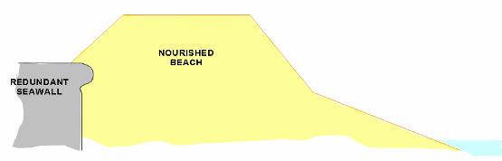
12 510,000 cubic metres of shingle Cost ~ 4,000, Beach Nourishment
13 Beach Management on Hayling Island Beach Nourishment Beach Recycling
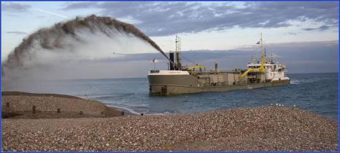
14 BEACH NOURISHMENT


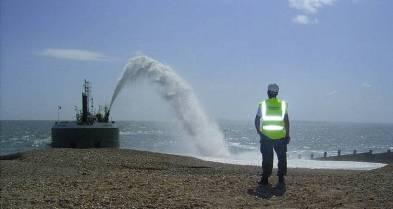
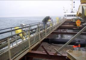
15 HOW DO WE RECYCLE THE BEACH?
16 HISTORICAL BEACH RECYCLING VOLUMES Year Volume (m 3 ) Year Volume (m 3 ) , , , ,006 50, , , , , , , , , , , , , ,256 26, ,648 75,000 25,000 65, , , , , ,400 Beach Nourishment - Recharge

17 RECYCLING AREA Drift Divide
. - Small scraping of material over a large area. - Cusps of accreted material.")
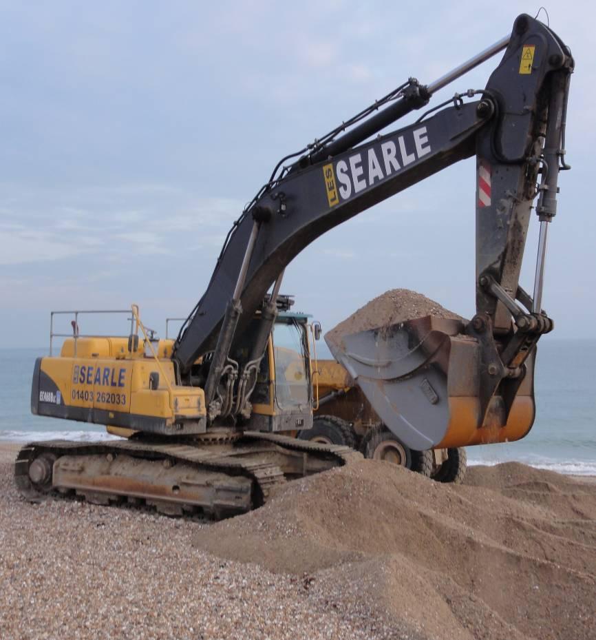
18 EXTRACTION SITES Open Beach Open Beach: - Accounts for about 50% of material recycled each year (23,000m3 in 2011). - Small scraping of material over a large area. - Cusps of accreted material. - Well sorted, course material.
. Well sorted very course material thrown up during winter storms.")
19 EXTRACTION SITES - Revetments Inn on the Beach and Coastguard Revetments: Accounts for about 10% of material recycled each year (5000m3 in 2011). Well sorted very course material thrown up during winter storms. Easy extraction but long haul distance (over 3km).
.")

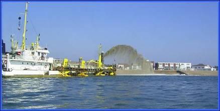
20 EXTRACTION SITES The Ness The Ness : Accounts for about 40% of material recycled each year (24,000m3 in 2011). Natural area of accretion inside Chichester Harbour Entrance. High fines content. Short haul distance, difficult extraction.


21 DEPOSITION Quantities required in each Groyne bay derived from pre operation topographic surveys. Managed on site to achieve correct distribution of material available. Bladed on site to achieve design profile. Courser Material used as a capping layer.
22 BEACH PROFILE Profile Location: 5a Elevation (maodn) Chainage (m) 05/04/2011 (Post-Operation) 17/02/2011 (Pre-Operation) DESIGN PROFILE
 Other Licences: -No FEPA Licence required -Essential Maintenance -No new deposits -CHC Works Licence -HCC Permission")
23 PLANNING, CONSENTS and LICENCES New 10 year Planning Permission ( ) Removal of restrictions on extraction quantities at the Ness. (Working with CHC) Other Licences: -No FEPA Licence required -Essential Maintenance -No new deposits -CHC Works Licence -HCC Permission


24 HEALTH and SAFETY Speed Limit 10mph Signage/Fencing at access points Haul Route Cones Banksmen HBC Counting Staff


25 VEGETATED SHINGLE Pre and Post Vegetated Shingle GPS Surveys Haul Routes marked out based on Vegetation locations Vegetated Shingle Reports West Sussex Vegetated Shingle Project Guidelines Working areas at Ness agreed with HCC

26 METHOD OF MEASUREMENT Drop Tests: Joint Measure Random measures Volume of a cone V = 1/3 π r^2 h V = 1/3 x π x 3.1^2 x 1.5 = 15.09m3 Counting Staff record each truck load deposited. Volumes calculated using this method compare well to truck manufacturers specifications and volumetric analysis of pre and post operation GPS surveys.
27 BILL ITEMS The contract is let annually on the basis of a re-measurable Bill of Quantities. X900.1 Extraction from below MLW Haul distance under 2.5km Typical present day rate ~ 2.30/m3 X900.2 Extraction from above MLW Haul distance under 2.5km Typical present day rate ~ 2.10/m3 X900.3 Extraction from above MLW Haul distance over 2.5km Typical present day rate ~ 3.00/m3 X900.4 Provide and place 20-40mm single size gravel aggregate Typical present day rate ~ 27.00/m3
28 CURRENT FDGiA FUNDING Year Approved Budget 2007/ , / , / , / , / ,000 TOTAL 638,000

29 NEW BEACH MANAGEMENT PLAN Currently writing a new Beach Management Plan South Hayling BMP rather than just Eastoke Better management of the frontage as a whole Liaison with numerous landowners Hayling Golf Club, HCC, HISC

30 Questions?
SOUTH HAYLING BEACH MANAGEMENT PLAN Executive Head Of Planning & Built Environment
 NON EXEMPT HAVANT BOROUGH COUNCIL Cabinet SOUTH HAYLING BEACH MANAGEMENT PLAN Executive Head Of Planning & Built Environment REPORTNO FOR DECISION Portfolio: CLLR D. GUEST - PLANNING & BUILT ENVIRONMENT
^ox, 7. Environment Agency. Hayling Island North Strategy *. M ^, v. * > -.
 ^ox, 7 Environment Agency Hayling Island North Strategy *. M ^, v. * > -. Consultation Document for Preferred Coastal Defence Options - Septem ber 2005 We are the Environment Agency. It s our job to look
DAMAGE ASSESSMENT OF SAND FENCING GARDEN CITY, NORTH LITCHFIELD AND LITCHFIELD BEACH GEORGETOWN COUNTY, SC
 OF SAND FENCING GARDEN CITY, NORTH LITCHFIELD AND LITCHFIELD BEACH GEORGETOWN COUNTY, SC June 07, 2017 PREPARED FOR: GEORGETOWN COUNTY DEPARTMENT OF PUBLIC SERVICES PREPARED BY: The EARTHWORKS Group 11655
The reasons why coastal management is needed in Minehead:
 1. Resource 1: Why did Minehead need new sea defences? Coastal management in Minehead In pairs, read the following resource and highlight the reasons why coastal management was needed in Minehead. The
MANAGING COASTAL HAZARDS THROUGH BENEFICIAL REUSE OF DREDGED SAND AND AN ADAPTIVE WORKS STRATEGY
 MANAGING COASTAL HAZARDS THROUGH BENEFICIAL REUSE OF DREDGED SAND AND AN ADAPTIVE WORKS STRATEGY Isabelle Ghetti 1, B.Morgan 2, R.Massie 1, Gary Blumberg 2 1 Shoalhaven City Council, Nowra, NSW 2 Royal
2011 Nags Head Beach Nourishment Project Update. Tim Kana & Haiqing Kaczkowski
 2011 Nags Head Beach Nourishment Project Update Tim Kana & Haiqing Kaczkowski NCBIWA Conference 3 April 2017 Outline of the Presentation 1 Review 2011 Nourishment Project Post-project monitoring efforts
The area involved 17th annual report
 The area involved 17th annual report MARINE AGGREGATE EXTRACTION 2014 Contents 01: Introduction Summary information 02-03: Summary statistics for 2014 04-05: Humber region 06-07: East Coast region 08-09:
CHAPTER 241. SAND BYPASSING TO "PLAYA DE CASTILLA" (HUELVA SPAIN) Jose Fernandez (1) Gregorio Gomez Pina (2) Angel Mufloz (3)
 Jose Fernandez (1) Gregorio Gomez Pina (2) Angel Mufloz (3)") CHAPTER 241 SAND BYPASSING TO "PLAYA DE CASTILLA" (HUELVA SPAIN) Jose Fernandez (1) Gregorio Gomez Pina (2) Angel Mufloz (3) Abstract The "Sand bypassing to Playa de Castilla" project consists of a sand
CHAPTER 241 SAND BYPASSING TO "PLAYA DE CASTILLA" (HUELVA SPAIN) Jose Fernandez (1) Gregorio Gomez Pina (2) Angel Mufloz (3) Abstract The "Sand bypassing to Playa de Castilla" project consists of a sand
The area involved 19th annual report
 The area involved 19th annual report MARINE AGGREGATE EXTRACTION 216 1: Introduction & Summary information Contents 1: Introduction Summary information 2-3: Summary statistics for 216 4-5: Humber region
WORKSHEET 24: Sand dunes - Conservation and management
 SAND DUNES - CONSERVATION AND MANAGEMENT MEETING THE CHALLENGE Sand dunes are: Excellent natural protection for the land A great recreational and educational area A specialised wildlife habitat But they
The area involved 20th annual report
 The area involved 2th annual report MARINE AGGREGATE EXTRACTION 217 Contents 1: Introduction Summary information 2-3: Summary statistics for 217 4-5: Humber region 6-7: East Coast region 8-9: Thames Estuary
Lidar Imagery Reveals Maine's Land Surface in Unprecedented Detail
 Maine Geologic Facts and Localities December, 2011 Lidar Imagery Reveals Maine's Land Surface in Unprecedented Detail Text by Woodrow Thompson, Department of Agriculture, Conservation & Forestry 1 Introduction
Coastal Trends Report. North-East Norfolk and North Suffolk (Subcell 3b - Kelling to Lowestoft) RP006/N/2008 April 2008
 RP006/N/2008 April 2008") Coastal Trends Report North-East Norfolk and North Suffolk (Subcell 3b - Kelling to Lowestoft) RP006/N/2008 April 2008 Title here in 8pt Arial (change text colour to black) i We are the Environment Agency.
Coastal Trends Report North-East Norfolk and North Suffolk (Subcell 3b - Kelling to Lowestoft) RP006/N/2008 April 2008 Title here in 8pt Arial (change text colour to black) i We are the Environment Agency.
Defending the coast at Dawlish Warren
 508 546 Sólheimajökull: Defending the coast a retreating Dawlish Icelandic Warrenglacier By By Simon Hilary Edge Sampson Today, ice covers around 10% of the A case study about world s surface. But, for
ANNUAL GENERAL MEETING OF NORTH EAST HAYLING RESIDENTS ASSOCIATION HELD AT NORTH HAYLING RECREATION HALL, HAYLING ISLAND
 ANNUAL GENERAL MEETING OF NORTH EAST HAYLING RESIDENTS ASSOCIATION HELD AT NORTH HAYLING RECREATION HALL, HAYLING ISLAND ON FRIDAY THE 16 TH MAY 2014 AT 7.30PM PRESENT Colin Hunt (chair) There were 48
DOVER WESTERN DOCKS REVIVAL (DWDR) NEWSLETTER. Spring 2016
 NEWSLETTER. Spring 2016") DOVER WESTERN DOCKS REVIVAL (DWDR) NEWSLETTER Spring 2016 WELCOME The Port handles 13 million passengers, 2.5 million freight vehicles and up to 119 billion of UK/European trade. It supports 22,000 jobs,
DOVER WESTERN DOCKS REVIVAL (DWDR) NEWSLETTER Spring 2016 WELCOME The Port handles 13 million passengers, 2.5 million freight vehicles and up to 119 billion of UK/European trade. It supports 22,000 jobs,
UAS to GIS Utilizing a low-cost Unmanned Aerial System (UAS) for Coastal Erosion Monitoring
 for Coastal Erosion Monitoring") UAS to GIS Utilizing a low-cost Unmanned Aerial System (UAS) for Coastal Erosion Monitoring Agenda Scope of today s presentation Demonstration Objectives Wrightsville Beach Test Area Masonboro Inlet Jetties
UAS to GIS Utilizing a low-cost Unmanned Aerial System (UAS) for Coastal Erosion Monitoring Agenda Scope of today s presentation Demonstration Objectives Wrightsville Beach Test Area Masonboro Inlet Jetties
Minerals & Waste Management Opportunity
 Subject To Contract August 2016 For Sale Finmere Quarry & Waste Management Complex Banbury Road Finmere Buckingham MK18 4AJ Minerals & Waste Management Opportunity gva.co.uk 1 Sand and Gravel Reserve Materials
Port of Durban. Entrance Channel Widening & Deepening Project Completion Function. 31 March 2010
 Port of Durban Entrance Channel Widening & Deepening Project Completion Function 31 March 2010 Presented by: Theunis Steenkamp Project Director Natcor 1 The saying goes.. THE JOB IS NOT OVER UNTILL THE
West of Wales Shoreline Management Plan 2 Section 4. Coastal Area E. February 2011 Consultation 9T9001
 West of Wales Shoreline Management Plan 2 Section 4. Coastal Area E February 2011 Consultation 9T9001 Rightwell House Bretton Peterborough PE3 8DW United Kingdom +44 (0)1733 334455 Telephone Fax info@peterborough.royalhaskoning.com
Geomorphology. Glacial Flow and Reconstruction
 Geomorphology Glacial Flow and Reconstruction We will use simple mathematical models to understand ice dynamics, recreate a profile of the Laurentide ice sheet, and determine the climate change of the
EFFECT OF THE COASTAL CONSERVATION DUE TO BEACH NOURISHMENT OF TOTORI SAND DUNE COAST
 Proceedings of the 7 th International Conference on Asian and Pacific Coasts (APAC 203) Bali, Indonesia, September 2-26, 203 EFFECT OF THE COASTAL CONSERVATION DUE TO BEACH NOURISHMENT OF TOTORI SAND DUNE
PLANNING COMMISSION MEETING MINUTES October 25, :00 p.m.
 PLANNING COMMISSION MEETING MINUTES 7:00 p.m. 1) Call to Order Commission members present: Chair Heck, Strandell, Warner, Sandholm, and Stulberg. Commission members absent: Pollmann, Watson. Staff present:
Impact of Offshore Directed Forcing on Sediment Transport and Structural Integrity at Packery Channel, Corpus Christi Texas
 Google Earth 29 Aug 2017 Impact of Offshore Directed Forcing on Sediment Transport and Structural Integrity at Packery Channel, Corpus Christi Texas Deidre D. Williams Coastal Research Scientist Conrad
Introduction to Map 14: Fionn-phort to Caol Ila
 Introduction to Map 4: Fionn-phort to Caol Ila This map section covers some 3.8km of coastline. In the southern and central part of this section the landscape is dominated by open moorland, with scrub
Gwynedd Council Pwllheli Harbour maintenance dredging strategy Updated strategy report
 Pwllheli Harbour maintenance dredging strategy Issue 5 January 2016 This report takes into account the particular instructions and requirements of our client. It is not intended for and should not be relied
JOB DESCRIPTION FBO Manager
 JOB DESCRIPTION FBO Manager RESPONSIBLE TO: LOCATION: Managing Director London Biggin Hill Airport Ltd WHAT IS THE JOB LIKE? The role holder will have an oversight of operational issues and teams to ensure
Specification for Grip blocking using Peat Dams
 Technical Guidance Note 1 Specification for Grip blocking using Peat Dams 1. Introduction Moorland drains (grips) have been dug across much of the Yorkshire upland peatlands. Many of these grips have become
Remote Sensing into the Study of Ancient Beiting City in North-Western China
 Dingwall, L., S. Exon, V. Gaffney, S. Laflin and M. van Leusen (eds.) 1999. Archaeology in the Age of the Internet. CAA97. Computer Applications and Quantitative Methods in Archaeology. Proceedings of
Kirkcaldy Sea Wall Improvements. Non-technical Summary. For illustration purposes only to give an indicative representation of the scheme.
 ENVIRONMENTAL STATEMENT Non-technical Summary For illustration purposes only to give an indicative representation of the scheme. Kirkcaldy Sea Wall Improvements Introduction A concrete sea wall fronts
Collyers Farm. Lickfold West Sussex
 Collyers Farm Lickfold West Sussex A beautiful period farmhouse, Listed Grade II with stables and outbuildings, mature landscaped gardens and paddocks, set in about 22 acres Features Hall Drawing room
Verdley Edge Henley Hill, Haslemere, Surrey. People Property Places
 Verdley Edge Henley Hill, Haslemere, Surrey People Property Places A well presented period house, originating from the 14th Century with Georgian and later additions, now providing generous accommodation
IMPORTANT DEFINITIONS DEFINITIONS FROM TOPO MAPS
 IMPORTANT DEFINITIONS DEFINITIONS FROM TOPO MAPS 1. REPRESENTATIVE FRACTION (RF): It is the ratio between the distances on the map to its corresponding distance on actual ground. The RF on this map is
Maximising Beneficial Reuse through the use of a Novel Dredging Contract
 Maximising Beneficial Reuse through the use of a Novel Dredging Contract Nicola Clay & Katherine Harris Port of London Authority Nick Bray Dredging Research Paul Hesk Van Oord UK CEDA Dredging Days 2007
Chile Earthquake 2010
 Chile Earthquake 2010-8.8 magnitude - 500 killed - 12000 injured - $30 billion damage - Santiago evacuated - Tsunami warnings www.teachitgeography.co.uk 2018 32657 Page 1 of 18 Nepal Earthquake 2015-7.8
A Brief History of the Town of Palm Beach Coastal Protection Program. Beach nourishment occurred in Palm Beach as far back as the 1940s.
 A Brief History of the Town of Palm Beach Coastal Protection Program Beach nourishment occurred in Palm Beach as far back as the 1940s. The Lake Worth Inlet Sand Transfer Plant was built in the late 1950s.
The Northeast: America's Gateway to the World
 The Northeast: America's Gateway to the World Living in the Shadow of the Ice a lesson on the impact of glaciation on Northeast landscapes INTRODUCTION: The region we call the Northeast has a very long
The Physical Geography of Long Island
 The Physical Geography of Long Island A Bit About Long Island Length 118 miles Brooklyn to Montauk Geo202 Spring 2012 Width 23 miles at it s widest Area 1,400 square miles Formation of Long Island River
THE ICs INTERNATIONAL BRISBANE AREA AQUA PARK PROPOSAL
 Contacts: Mr Evan Pryor, Ph 38702756, evanpryor2002@yahoo.com.au Mr Bob Beatty, Ph 32883101, BobBeatty@BOSMIN.com Web Address: http://www.bosmin.com/ics/icharter.htm Postal Address: GPO Box 2927, Brisbane,
Les Chemins de Fer du Sud de la France, Ligne de Central Var. History of the Line to 1925
 Les Chemins de Fer du Sud de la France, Ligne de Central Var History of the Line to 1925 The Treaty of Turin was signed on 24 th March 1860. In it Nice was ceded by the King of Sardinia to Napoleon III.
The Galveston Seawall
 Coastal and Ocean Engineering ENGI.8751 Undergraduate Student Forum Faculty of Engineering and Applied Science, Memorial University, St. John s, NL, Canada. March, 2013 The Galveston Seawall Mark Harvey
Wheatlands House, Fleet Hill, Finchampstead, Berkshire
 Wheatlands House, Fleet Hill, Finchampstead, Berkshire An Archaeological Watching Brief For JCA International by James McNicoll-Norbury Thames Valley Archaeological Services Ltd Site Code WFF 08/26 August
City of Fort Lauderdale. Frequently Asked Questions. Proposed Sea Wall Ordinance
 City of Fort Lauderdale Frequently Asked Questions Proposed Sea Wall Ordinance The City of Fort Lauderdale is considering amending the Unified Land Development Regulations of the City of Fort Lauderdale
A high resolution glacier model with debris effects in Bhutan Himalaya. Orie SASAKI Kanae Laboratory 2018/02/08 (Thu)
") A high resolution glacier model with debris effects in Bhutan Himalaya Orie SASAKI Kanae Laboratory 2018/02/08 (Thu) Research flow Multiple climate data at high elevations Precipitation, air temperature
A high resolution glacier model with debris effects in Bhutan Himalaya Orie SASAKI Kanae Laboratory 2018/02/08 (Thu) Research flow Multiple climate data at high elevations Precipitation, air temperature
Overview of Highway 37 Project. Napa County Board of Supervisors December 20, 2016
 Overview of Highway 37 Project Napa County Board of Supervisors December 20, 2016 1 Project Location-Caltrans District 4 2 SR 37 Corridor Features 2 to 4 lane 21 mile corridor traversing Solano, Sonoma,
March 2, The Honorable Mayor Williams D. Sessoms, Jr. Members of City Council. Subject: Coastal CIP Presentation to City Council - March 6, 2018
 OFFICE OF THE CITY MANAGER (757) 385-4242 (757) 427-5626 FAX MUNICIPAL CENTER BUILDING 1, ROOM 234 2401 COURTHOUSE DRIVE VIRGINIA BEACH, VA 23456-9001 March 2, 2018 The Honorable Mayor Williams D. Sessoms,
Chapter 10. Damage to Ports and Coastal Facilities
 Chapter 10 Damage to Ports and Coastal Facilities 10.1 Area Investigated Tsunami induced heavy damage to ports and coastal facilities along the west and north coast of Sumatra Island. Figure 10.1 shows
RURAL LAND RESOURCES Case study area 1- the erosional features of the Dorset Coast.
 Case study area 1- the erosional features of the Dorset Coast. Scene setting;- This area lies on the far south coast of England, between the settlements of Lyme Regis and Bournemouth, in the county of
MORAY COAST TRAIL - Notes on multi-use access
 MORAY COAST TRAIL - Notes on multi-use access The Moray Coast Trail in the north-east of Scotland is one of Scotland s Great Trails. Approximately 50 miles long, the route links settlements between Findhorn
Cambridge International Examinations Cambridge International General Certificate of Secondary Education
 Cambridge International Examinations Cambridge International General Certificate of Secondary Education *0710028496* GEOGRAPHY 0460/23 Paper 2 October/November 2016 Candidates answer on the Question Paper.
GUIDANCE ON CIVIL AVIATION AUTHORITY (CAA) PLANNING CONSULTATION REQUIREMENTS. 2 August Introduction
 PLANNING CONSULTATION REQUIREMENTS. 2 August Introduction") GUIDANCE ON CIVIL AVIATION AUTHORITY () PLANNING CONSULTATION REQUIREMENTS 2 August 2012 1. Introduction 1.1 As a general rule, decisions concerning local land use and planning issues, including cases
GUIDANCE ON CIVIL AVIATION AUTHORITY () PLANNING CONSULTATION REQUIREMENTS 2 August 2012 1. Introduction 1.1 As a general rule, decisions concerning local land use and planning issues, including cases
HENLEAZE, STOKE BISHOP & WESTBURY-ON-TRYM NEIGHBOURHOOD PARTNERSHIP September Chock Lane Traffic Calming scheme Monitoring Report
 HENLEAZE, STOKE BISHOP & WESTBURY-ON-TRYM NEIGHBOURHOOD PARTNERSHIP September 2015 Title: Officer: Chock Lane Traffic Calming scheme Monitoring Report Rob Grieve, Principal Officer, Highways and Traffic,
Overview of Highway 37 Project. Novato Rotary November 4, 2016
 Overview of Highway 37 Project Novato Rotary November 4, 2016 Project Location-Caltrans District 4 SR 37 Corridor Features Two to Four lane 21 mile corridor traversing Solano, Sonoma, and Marin Counties.
Pen y Chain to Trwyn Cilan
 PDZ 13. THE SOUTH LLYN BAYS: Abersoch Pen y Chain to Trwyn Cilan CONTENTS Page PDZ 13 THE SOUTH LLYN BAYS: 257 1 Local Description 260 2 Coastal Processes 265 3 Management Scenarios 275 4 Summary Comparison
9 Tithe Barn Close. Aldwick Bay Estate, Aldwick, West Sussex, PO21 4EY. humberts.com
 9 Tithe Barn Close Aldwick Bay Estate, Aldwick, West Sussex, PO21 4EY humberts.com 9 Tithe Barn Close Aldwick Bay Estate, Aldwick, West Sussex, PO21 4EY A 3/4 bedroom detached chalet style bungalow with
Hurricane Irma: Palm Beach County Coastal Storm Damage Assessment
 Project Area: Coral Cove Park Location: R1 to R7.5 Project Length: 5,170 ft Estimated Volumetric Loss: 38,296 cy Pre-Storm Assessment Date: August 22, 2017 General observations: 30 ft loss of dry beach
MORGAN CREEK GREENWAY Final Report APPENDICES
 APPENDICES MORGAN CREEK GREENWAY Appendix A Photos of Existing Conditions in Trail Corridor Photos of existing conditions Main trail corridor - February 2009 Photos of existing conditions south bank Morgan
THE GREAT MAN-MADE RIVER PROJECT
 WATER RESOURCES IN LIBYA Only 5% of the entire area of Libya exceeds 100 mm GROUND WATER 95.6% (4 in) annually. Evaporation rates are also high ranging SURFACE from WATER 700 mm (28 in) 2.3% in the north
St. Augustine Port, Waterway & Beach District. St. Augustine Inlet 2013 draft Inlet Management Plan. March 19, 2013
 Division of Water Resource Management St. Augustine Port, Waterway & Beach District St. Augustine Inlet 2013 draft Inlet Management Plan March 19, 2013 Discussion Outline Florida Statutes Florida Inlets
DEFINITIONS DEFINITIONS 2/11/2017 REQUIREMENTS AND LIMITATIONS OF DRONE USE IN FORENSIC ACCIDENT RECONSTRUCTION
 REQUIREMENTS AND LIMITATIONS OF DRONE USE IN FORENSIC ACCIDENT RECONSTRUCTION ROGER BURGMEIER BURGMEIER CONSULTING INC. DEFINITIONS Aircraft: device that is used, or intended to be used, for flight. Drone:
Edisto Beach Renourishment and Groin Lengthening Project. Tim Kana Coastal Science & Engineering
 Edisto Beach Renourishment and Groin Lengthening Project Tim Kana Coastal Science & Engineering Hurricane Matthew 8 Oct 2016 Cat 1 Storm @ Edisto Beach Worst Surge Event Since DAVID in 1979 Tides ~ 5 ft
LOW DOWN ON THE HIGH UP: USING DRONES FOR LAND CONSERVATION
 LOW DOWN ON THE HIGH UP: USING DRONES FOR LAND CONSERVATION TEXAS LAND CONSERVATION CONFERENCE MARCH 3, 2017 STEPHEN RAMIREZ STEWARDSHIP DIRECTOR TEXAS LAND CONSERVANCY RAY RENNER, RPLS, PMP MANAGER OF
LAND AT WORSLEY ROAD NEWPORT, ISLE OF WIGHT
 The Estate Office 13 High Street Bembridge, Isle of Wight, PO35 5SD Tel: 01983 872335 Fax: 01983 872279 bembridge@creasey-biles-king.co.uk www.creasey-biles-king.co.uk LAND AT WORSLEY ROAD NEWPORT, ISLE
National Rail Passenger Survey: User Guidance Report. Autumn 2013 (wave 29)
") National Rail Passenger Survey: User Guidance Report Autumn 2013 (wave 29) Rebecca Joyner Research Director Tel: 020 7490 9148 rebecca.joyner@bdrc continental.com Contents Page No. 1. Background... 1 2.
National Rail Passenger Survey: User Guidance Report Autumn 2013 (wave 29) Rebecca Joyner Research Director Tel: 020 7490 9148 rebecca.joyner@bdrc continental.com Contents Page No. 1. Background... 1 2.
Work Zone. Steve Hubbard: Lane Construction Safety Training Manager. Michael Grey: Rea Contracting Project Superintendent
 Access and Egress Into the Work Zone Steve Hubbard: Lane Construction Safety Training Manager Michael Grey: Rea Contracting Project Superintendent Access and Egress Into the Work Zone THE TYPICAL INTERSTATE
Steep House, Lower Steep House & Old Portmellon Cottage. Portmellon Nr Mevagissey South Cornwall
 Steep House, Lower Steep House & Old Portmellon Cottage Portmellon Nr Mevagissey South Cornwall Steep House, Lower Steep House & Old Portmellon Cottage Portmellon Nr Mevagissey South Cornwall An outstanding
APPENDIX A. Condition Survey of Pavements Concrete Mixture Proportions Used in Pavements Deicer Usage on Pavements Core Locations and Core Catalog
 APPENDIX A (i) (ii) (iii) (iv) Condition Survey of Pavements Concrete Mixture Proportions Used in Pavements Deicer Usage on Pavements Core Locations and Core Catalog Report IPRF-01-G-002-05-7 Appendix
The major parties key coastal policy initiatives
 NEWSLETTER July 2016 EDITORIAL: Coastal policies of major parties inadequate By Barry Sammels Chair, Australian Coastal Councils Association and Mayor, City of Rockingham With the result of the 2016 Federal
THE STUDY FOR COASTAL EROSION AND FLOOD CONTROL MANAGEMENT IN THE REPUBLIC OF SEYCHELLES FINAL REPORT
 MINISTRY OF ENVIRONMENT AND ENERGY REPUBLIC OF SEYCHELLES THE STUDY FOR COASTAL EROSION AND FLOOD CONTROL MANAGEMENT IN THE REPUBLIC OF SEYCHELLES FINAL REPORT MARCH 2014 JAPAN INTERNATIONAL COOPERATION
Sustainable development: 'Lanzarote and the Biosphere strategy'. LIFE97 ENV/E/000286
 Sustainable development: 'Lanzarote and the Biosphere strategy'. LIFE97 ENV/E/000286 Project description Environmental issues Beneficiaries Administrative data Read more Contact details: Project Manager:
CLYDE MAP 6: ERSKINE HARBOUR to north of DOVE COTTAGE
 CLYDE MAP 6: ERSKINE HARBOUR to north of DOVE COTTAGE Hinterland Geology and Coastal Geomorphology: The hinterland is dominated by marine deposits resting on undifferentiated glacial till. The foreshore
Alternative Highest & Best Use Analysis Boutique Hotel
 Alternative Highest & Best Use Analysis In response to numerous comments received from the public, as well as issues raised by the CCC in the Appeal Staff Report Substantial Issue Determination, the following
Dove Rock PLAIDY CORNWALL
 Dove Rock PLAIDY CORNWALL Dove Rock PLAIDY CORNWALL Looe 1 mile, Plymouth 18.5 miles, Cornwall Airport Newquay 37.5 miles, Exeter Airport 65 miles. (All distances and times are approximate) An immaculately
Appendix I: Metadatabase and Bibliographic Database
 Appendix I: Metadatabase and Bibliographic Database This Appendix includes a list of the key reference materials used in the development of the Shoreline Management Plan. The list is split into two sets,
KKC can provide the total solution from Data capturing to Consulting
 Crowdsource Mapping Response to the Great East Japan Earthquake Kunihiro ISHII kunihiro_ishii@kk-grp.jp Business Fields of KOKUSAI KOGYO(KKC) KKC can provide the total solution from Data capturing to Consulting
our newsletters, please do let us know by contacting Katie Orchin on or
 ISSUE 11 SPRING 2015 INSIDE: New website launched. Efficiency gains through investment. Dry Dock Cooperation. Coast protection boost. Diary of Events. Community focus for the future. Sustainable development
Document Control Identification. Document History. Authorisation. Rail Safety Manager Brookfield Rail
 Document Control Identification Document History Authorisation Rail Safety Manager Brookfield Rail Table of Contents Glossary for this Rule... 4... 6... 6... 6... 6... 8... 8... 8... 9... 10... 10 Glossary
Conservatory Roof Structural Information Guide
 Conservatory Roof Structural Information Guide Effective from March 2012 Now includes wide span capabilities Tel: 01623 443200 www.synseal.com Useful Information This guide displays data on the permissible
2014 UPDATE TO THE 2010 REPORT ADAPTING TO COASTAL FLOODING IN THE YARMOUTH AREA IN THE 21 ST CENTURY
 2014 UPDATE TO THE 2010 REPORT ADAPTING TO COASTAL FLOODING IN THE YARMOUTH AREA IN THE 21 ST CENTURY REPORT BY YARMOUTH COASTAL DEFENCE WORKING GROUP 2014 UPDATE TO THE 2010 REPORT ADAPTING TO COASTAL
NAUTILUS SOUTHAMPTON ROAD, PORTSMOUTH PO6 4RY
 NAUTILUS SOUTHAMPTON ROAD, PO6 4RY HARBOUR VIEWS EXCLUSIVE DEVELOPMENT WITHIN WALKING DISTANCE OF PORT SOLENT. STUNNING MIX OF 2,3,&4 BEDROOM HOMES NAUTILUS Nautilus is an exclusive private development
Sizing up Australia s eastern Grey Nurse Shark population
 Image: David Harasti A new estimate of adult population size for Australia s eastern Grey Nurse Shark drew on widespread genetic sampling and forensic exploration of family trees. Grey Nurse Sharks are
Environmentally Sensitive Maintenance for Dirt & Gravel trails TRAIL MIX. TRAIL MIX: aggregate for trails
 TRAIL MIX: aggregate for trails Environmentally Sensitive Maintenance for Dirt & Gravel trails Penn State University: Center for Dirt and Gravel Road Studies Dave Shearer drs32@psu.edu www.dirtandgravelroad.org
PARCS UPDATE #10 AUGUST 6, 2010
 PARCS UPDATE #10 AUGUST 6, 2010 Page 1 of 5 1. A PROFILE OF LAKE COUNTRY The RM of Lakeland lives up to its name. The only rural municipality in Saskatchewan with no farmland, the RM of Lakeland is a land
Attachment G STREAM IMPACTS. Ridge Road Extension Alternatives Analysis
 Attachment G STREAM IMPACTS for: Ridge Road Extension Alternatives Analysis PREPARED FOR: Pasco County Engineering Services Department PREPARED BY: NV5, INC. 6989 E. FOWLER AVENUE TAMPA, FLORIDA 33617
APPENDIX D: SUSTAINABLE TRAIL DESIGN. APPENDICES Town of Chili Parks and Recreation Master Plan Update
 APPENDIX D: SUSTAINABLE TRAIL DESIGN APPENDICES Town of Chili Parks and Recreation Master Plan Update Sustainable Trail Construction Sustainable trails are defined by the US Forest Service as trails having
The Croft LOWER ASHTON, EXETER, DEVON
 The Croft LOWER ASHTON, EXETER, DEVON The Croft LOWER ASHTON, EXETER, DEVON Chudleigh 5 miles Exeter 8 miles (London Paddington 2 hours) Moretonhampstead 8 miles Bovey Tracey 7 miles (All distances and
LOUGHBOROUGH INLET. Jason Zroback. Direct Line: (604) TOLL FREE:
 TOLL FREE:") LOUGHBOROUGH INLET www.landquest.com Jason Zroback Direct Line: (604) 414-5577 101-313 Sixth Street, New Westminster, BC V3L 3A7 Phone: (604) 664-7630 Fax: (604) 516-6504 TOLL FREE: 1-866-558-5263 Loughborough
LOUGHBOROUGH INLET www.landquest.com Jason Zroback Direct Line: (604) 414-5577 101-313 Sixth Street, New Westminster, BC V3L 3A7 Phone: (604) 664-7630 Fax: (604) 516-6504 TOLL FREE: 1-866-558-5263 Loughborough
Review of Highcliffe Shopping Centre
 Review of Highcliffe Shopping Centre A Summary M W Mawbey 15 th December 2013 INTRODUCTION Concern for the health of high streets is common theme across the country. High streets have been affected by
Access Statement for Birling Gap
 This access statement does not contain personal opinions as to our suitability for those with access needs, but aims to accurately describe the facilities and services that we offer all our guests/visitors.
A FIELDWALKING PROJECT AT HOLLINGBURY, BRIGHTON. by JOHN FUNNELL
 Introduction A FIELDWALKING PROJECT AT HOLLINGBURY, BRIGHTON by JOHN FUNNELL Members of the Brighton and Hove Archaeological Society walked the field at Hollingbury during the months of December 1991 and
Common Ground Drainage Channel Diversion. Design Report
 Common Ground Drainage Channel Diversion Design Report Resource Management International Inc Consulting Engineers May 2017 COMMON GROUND DRAINAGE CHANNEL DIVERSION PREPARED FOR: QUILL LAKES WATERSHED NO.
Sandbag Barrier. Suitable Applications Sandbag barriers may be suitable: As a linear sediment control measure:
 Categories EC Erosion Control SE Sediment Control TC Tracking Control WE Wind Erosion Control Non-Stormwater NS Management Control Waste Management and WM Materials Pollution Control Legend: Primary Category
General Aviation Economic Footprint Measurement
 General Aviation Economic Footprint Measurement Round Table Discussions ATAC, Ottawa Thursday, March 1 st, 2007 Presentation Outline Electronic Collection of Air Transportation Statistics (ECATS) at Transport
USGS Methods of Collecting High Water Marks (HWMs)
") USGS Methods of Collecting High Water Marks (HWMs) A. Thomas Ruby III Supervisory Hydrologist Indiana-Kentucky Water Science Center U.S. Department of the Interior U.S. Geological Survey Outline: Overview
USGS Methods of Collecting High Water Marks (HWMs) A. Thomas Ruby III Supervisory Hydrologist Indiana-Kentucky Water Science Center U.S. Department of the Interior U.S. Geological Survey Outline: Overview
1. Permittee: Department of Public Works and Government Services, Charlottetown, Prince Edward Island.
 Department of the Environment Canadian Environmental Protection Act, 1999 Notice is hereby given that, pursuant to section 127 of the Canadian Environmental Protection Act, 1999 (CEPA 1999), Disposal at
Northeast Stoney Trail In Calgary, Alberta
 aci Acoustical Consultants Inc. 5031 210 Street Edmonton, Alberta, Canada T6M 0A8 Phone: (780) 414-6373, Fax: (780) 414-6376 www.aciacoustical.com Environmental Noise Computer Modelling For Northeast Stoney
BEST & FINAL OFFERS INVITED BY FRIDAY 10th JUNE 2016
 KINGSTONWHARF SHOREHAM RESIDENTIAL/MIXED USE OR COMMERCIAL 3.96 Acres (1.605 ha) Freehold For Sale Shoreham KINGSTON WHARF Shoreham Port Shoreham Beach Kingston Wharf, Brighton Road, Shoreham By Sea, West
Mountain Valley Pipeline, LLC Mountain Valley Pipeline Project Docket No. CP
 16. Prior to construction, Mountain Valley shall file with the Secretary, for review and approval by the Director of OEP, a segment-specific construction and operation access plan for the area between
THE SOLENT S PREMIER CENTRE OF EXCELLENCE FOR AVIATION, AEROSPACE, MARINE, ENGINEERING AND ADVANCED MANUFACTURING.
 THE SOLENT S PREMIER CENTRE OF EXCELLENCE FOR AVIATION, AEROSPACE, MARINE, ENGINEERING AND ADVANCED MANUFACTURING. WITH AN ENVIABLE LOCATION ON THE SOUTH COAST, WELL-CONNECTED BY ROAD, RAIL AND AIR, DAEDALUS
A detached period home with loch views. rhu house by tarbert, argyll, pa29 6yf
 A detached period home with loch views rhu house by tarbert, argyll, pa29 6yf A detached period home with loch views rhu house by tarbert, argyll, pa29 6yf Porch sitting room drawing room dining room