2014 UPDATE TO THE 2010 REPORT ADAPTING TO COASTAL FLOODING IN THE YARMOUTH AREA IN THE 21 ST CENTURY
|
|
|
- Beatrice Brooks
- 5 years ago
- Views:
Transcription

1 2014 UPDATE TO THE 2010 REPORT ADAPTING TO COASTAL FLOODING IN THE YARMOUTH AREA IN THE 21 ST CENTURY REPORT BY YARMOUTH COASTAL DEFENCE WORKING GROUP

2 2014 UPDATE TO THE 2010 REPORT ADAPTING TO COASTAL FLOODING IN THE YARMOUTH AREA IN THE 21ST CENTURY CONTENTS CONTENTS... 1 INTRODUCTION... 2 CHANGES SINCE SUMMARY OF 2014 UPDATE... 4 THE SCIENTIFIC BASIS FOR CONCERN: UPDATE IN THE LIGHT OF STORM SURGES IN YARMOUTH HARBOUR OCTOBER 2013 FEBRUARY SUMMARY OF SCIENTIFIC BASIS FOR CONCERN... 7 LOCAL ASSETS AT RISK 2014 UPDATE... 8 BOULDNOR ROAD (A3054)... 8 AMENITIES AND UTILITIES... 8 A POSSIBLE FUTURE SCENARIO... 8 FUNDING AND LEGISLATIVE CONSTRAINTS UPDATE... 9 SOME POSSIBLE SOLUTIONS 2014 UPDATE BY YEAR TEN BY YEAR FORTY BY YEAR NINETY PUBLIC AWARENESS LINKS TO FURTHER INFORMATION P a g e 1

3 INTRODUCTION Much of the town of Yarmouth and the surrounding area lie only a couple of metres above mean sea level and a combination of a Storm Surge and High Spring Tide can cause flooding. To date the effects of such flooding have been relatively minor but, with sea level predicted to rise at increasing rates this century, flooding will become more serious and more frequent. In 2010 the Coastal Defence Working Group prepared a report (Adapting to Coastal Flooding in the Yarmouth Area in the 21 st Century) with the aim of raising awareness of the associated issues with policy makers and the local community. It outlined the scientific basis for concern, identified local assets that may be at risk and suggested possible measures to alleviate any impact. The Working Group also aimed to increase the profile of Yarmouth in discussions on the priorities and funding of Isle of Wight coastal defence. Since producing the report the Working Group has remained active in raising awareness of coastal flooding in Yarmouth, both with policy makers and the local community. It has continued to monitor storm surge and flood levels and based on this information has revised previous estimates both for the height and frequency of the storm surge likely to be seen and the costs associated with proposed actions. CHANGES SINCE 2010 There has been considerable progress in many areas and this summary has been produced to provide an update to the original 2010 report. The following points are the main areas of change relevant to coastal flooding in Yarmouth and the surrounding area: Storm surges and flooding events in Yarmouth since 2010, including the flooding associated with the storm surge on 14 th February Production of the Yarmouth Community Flood Plan in Adoption of the Isle of Wight Shoreline Management Plan in Discussion about the trialling of temporary flood barriers in Yarmouth. The predicted lifespan of the existing Yarmouth Harbour breakwater (20 years) and the completion of a scoping document regarding its future. P a g e 2

4 Coastal Communities Adapting to Coastal Change (CCATCH) was part of the EU funded CC2150. The existence and previous activities of the Working Group was a major factor in the selection of Yarmouth as one of the six sites around the Solent to receive funding and actions from the project. The project created a 3D fly-through of the area at various levels of tide, now and predicted. It also developed an award winning schools programme to investigate and discuss the issues associated with flooding from the sea. The Totland to Colwell seawall collapse (in 2012) and the impact of the 2013 / 2014 winter storms on the Island s coastal defence resources. Substantial structural work carried out on the Bouldnor Road in 2013 / Change in political control of the Isle of Wight Council (IWC) in 2013 and the need to involve all political parties and develop a long term, sustainable strategy. The impact of unprecedented spending cuts within IWC. In 2013 Island Roads replaced the IWC Highways department under a 25 year PFI contract. The Marine Management Organisation (MMO) began operating in 2010 and was established under the Marine and Coastal Access Act It is an executive non-departmental public body that brings together key marine decision-making powers and delivery mechanisms. It deals with marine planning, licensing, protected areas and fisheries. Proposals for a Marine Conservation Zone along the coast and the potential impact that associated management may have on the future development of coastal defence structures. Increased public demand for clarity regarding the balance between property and wildlife in flood defence policy. Public interest and confusion regarding the roles and responsibilities of Government, national agencies, local authorities and water companies. Impact of dramatic flooding in the UK on public consciousness. P a g e 3

 which was adopted by the IWC and Environment Agency (EA) in May 2011.")
5 SUMMARY OF 2014 UPDATE In 2010 the conservative assumption of the maximum storm surge that Yarmouth would expect in 21 st Century was 1.1 metres. As detailed in section 2, this has been revised upwards to 1.4 metres based on the events in October 2013 and February The frequency of storm surges is also likely to increase and the extent of flooding become more widespread. The 2010 report fed into the development of the Isle of Wight s second Shoreline Management Plan (SMP2) which was adopted by the IWC and Environment Agency (EA) in May Details about the policies set out for the sustainable management of the coast can be found at Subsequent to the adoption of the SMP2, funding has now been secured by the IWC to resume work on the West Wight Coastal Defence Strategy Study. Work on an associated study in 2006 (by the consultancy Atkins) went no further than the first round of public consultation. Over the next two years the Working Group will assist in the development of the Strategy Study through the provision of local information and by raising awareness of public consultation(s). Funding constraints continue and local and national grant funding is likely to be increasingly difficult to obtain. The estimated costs associated with coastal defence work and flood adaptation have been revised from 190,000 to 270,000 before 2020, 9.8 million to 21 million by 2050 and 26.1 million to 30.1 million before P a g e 4
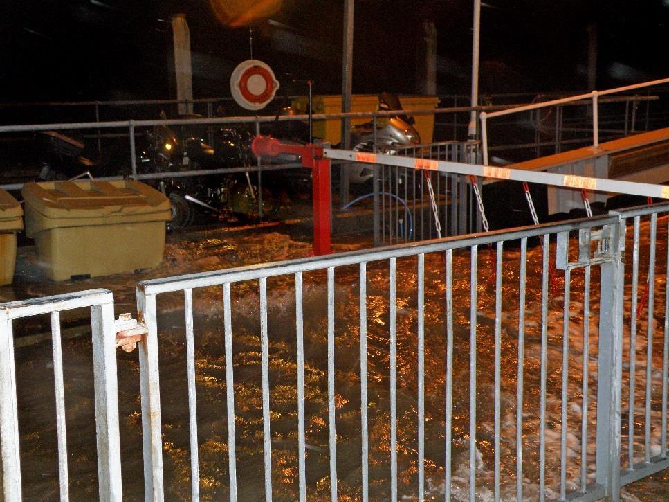
6 THE SCIENTIFIC BASIS FOR CONCERN: UPDATE IN THE LIGHT OF STORM SURGES IN YARMOUTH HARBOUR OCTOBER 2013 FEBRUARY 2014 Extract: Full version of this updated section and references are available at: The UK Meteorological Office (Met Office) reported that the winter 2013/2014 was an exceptionally stormy season, with at least 12 major winter storms affecting the UK in two spells from mid-december to early January, and again from late January to mid-february. There were more very severe gale days than any other winter season in a series from It was also the wettest winter for England, Wales and Scotland in a series from Mean temperatures over the UK were well above the long term average with a notable absence of frosts. The winter was also exceptional for Yarmouth in the number of times that the sea rose above the quay, flooding the marshalling area and adjacent roads at times. The frequency of major storm surges was much greater than Yarmouth had experienced before. It is important to stress that the flooding in Yarmouth was due to storm surges, driven by the patterns of wind and air pressure in the storms moving into northwest Europe from the Atlantic, and not due to the heavy rainfall. The storm surges experienced in Yarmouth covered a greater span of time than those in the Met Office assessment above. The first major storm surge arrived on 28 th October 2013 and the last on 14 th February 2014 ('the St Valentine s Day storm'). Prior to this winter s events, the last major storm surge experienced at Yarmouth occurred on 10 th March That event was discussed in detail in the 2010 report and, at that time, it was thought that comparable storm surges could be expected to occur roughly every 20 years. The average height of the quay in Yarmouth is about 3.9 metres above Chart Datum. If one defines a significant storm surge (for Yarmouth) as one which reaches or exceeds the height of the quay, six such events were observed between October and February, as shown in the table below. Date Predicted tide (UK Hydrographic Office) Observed tide (at Yarmouth) Height of storm surge 10 th March 2008 Noon 3.0m 4.1m 1.1m 28 th October :23 2.6m 4.01m 1.4m 4 th November :26 3.1m 3.97m 0.9m 5 th November :02 3.1m 3.85m 0.75m 6 th December :16 3.1m 3.83m 0.7m 3 rd January :18 3.1m 3.80m 0.7m 14 th February :37 2.9m 4.15m 1.25m Table 1. Storm surge observations in Yarmouth Harbour, March 2008 and 2013/2014. There may have been a few large storm surges, comparable to those in the table above, which were not identified at Yarmouth. This was because they did not coincide with the astronomical prediction of high water. Many more, smaller storm surges were also observed. However, the 14 th February flooding was more widespread than that of 2008, possibly due to the very strong south westerly wind (Force 12 at times), which also caused waves on top of the flood water. Affected areas were the whole P a g e 5

7 of the quay area and adjoining properties, ferry terminal, most of Quay Street and northern part of Wheatsheaf Lane, western part of Bridge Road, parts of the A3054 road from the School to a good way west of the Yar Bridge, Gasworks Lane, the River Yar Boatyard, part of the estuary's eastern footpath and those by the Mill, Mill Field and part of the old railway line, Gossips Cafe and northern end of Pier Square. Damage also occurred to some jetties and seawalls of private properties in High Street and Port La Salle, to The Common seawall and parts of the Harbour. The height of flooding in these areas varied considerably due to different ground levels and wind exposure. The heights of the storm surges observed in Yarmouth were consistently greater than those recorded at Weymouth and Portsmouth, presumably due to tidal processes in the Solent. Date Weymouth Portsmouth Yarmouth 28 th October m 0.9m 1.4m 4 th November m 0.5m 0.9m 5 th November m 0.2m 0.75m 6 th December m 0.6m 0.7m 3 rd January m 0.5m 0.7m 14 th February m 1.0m 1.25m Table 2. Comparison of storm surge heights at Weymouth, Portsmouth and Yarmouth. The largest storm surge observed in Yarmouth from October 2013 to February 2014 occurred during neap tides on 28 th October 2013, resulting in minimal flooding. Scientists at the University of Southampton were particularly interested in this event, identifying a seiche in which the seawater oscillates back and forth across the Channel. P a g e 6
8 SUMMARY OF SCIENTIFIC BASIS FOR CONCERN In the 2010 report it was assumed that the maximum storm surge that Yarmouth would experience in the 21 st century would be 1.1 metres the height of that experienced on 10 th March This figure was then used to predict, taking into account sea level rise, the maximum sea level heights that Yarmouth could expect in 2050 and It is now clear, only six years after the March 2008 surge, that this figure should be revised upwards to 1.4 metres. This may still be a conservative assumption, but it remains important to use a figure which is firmly tied to the data. Hence the predictions for maximum sea level height in Yarmouth above Chart Datum in the 2010 report can be revised as follows: Year Highest Astronomical Tide Maximum Storm Surge Sea Level Rise Maximum Sea Level Height m 1.4m 0.3m 4.8m m 1.4m 0.9m 5.4m Table 3. Revised prediction of maximum sea level height above Chart Datum at high water for a high Spring Tide. Year Height of High Tide Maximum Storm Surge Sea Level Rise Maximum Sea Level Height m 1.4m 0.3m 4.3m m 1.4m 0.9m 4.9m Table 4. Revised prediction of maximum sea level height above Chart Datum for a typical high water Neap Tide. The frequency of occurrence of storm surges in Yarmouth also needs to be revised. In the 2010 report, it was thought that storm surges comparable to the March 2008 event could be expected to occur roughly every 20 years. Of the six significant storm surges experienced in Yarmouth in the five months from October 2013 to February 2014, three can be considered to be comparable to the March 2008 event. However, it is difficult to predict from this the frequency of occurrence of storm surges in decades to come without understanding more about long term weather trends. All one can say at present is that storm surges are likely to be more frequent in future than hitherto thought, and therefore that the chance of storm surges coinciding with high Spring or Neap Tides, and hence causing flooding, has increased. The heights of storm surges at Yarmouth were consistently greater than those observed for the comparable events at Weymouth and Portsmouth. Some scientists have claimed that one of the consequences of climate change will be increased storminess. In February 2014, a paper entitled The Recent Storms and Floods in the UK was published by the Met Office. The question of whether climate change contributed to the severity of the weather and its impacts is discussed. It recognises that Although no individual storm can be regarded as exceptional, the clustering and persistence of the storms is highly unusual. However, the paper concludes: In terms of the storms and floods of winter 2013/2014, it is not possible, yet, to give a definitive answer on whether climate change has been a contributor or not. P a g e 7
 The road is the main approach to Yarmouth from the east and required stabilisation.")

9 LOCAL ASSETS AT RISK 2014 UPDATE The local assets at risk are largely the same as those outlined in the 2010 report, however the threat of closure of the Military Road has been averted through remedial works and is now likely to be treated within the PFI contract. BOULDNOR ROAD (A3054) The road is the main approach to Yarmouth from the east and required stabilisation. Substantial structural geotechnical work was carried out between November 2013 and April The work involved strengthening a 700 metre stretch of the highway between the Viewpoint Car Park and Yarmouth Common with 750 steel sheet piles driven up to 16 metres into the ground. A process called soil nailing was also used to stabilise the road at the Yarmouth end of the scheme. AMENITIES AND UTILITIES It is important not to overlook public amenities and utilities such as roads, rights of way, water mains, sewage pipes, electricity cables, gas pipes and the harbour. These will all require significant investment by the relevant authorities in order that they may be protected. Concern has been raised about the location of substations in the area and their vulnerability to flooding. A POSSIBLE FUTURE SCENARIO In Yarmouth IF a high Spring tide (e.g. 3.1 metres) coincided with a storm surge of 1.4 metres, giving a total tide height of 4.5 metres, the flood water is likely to go into the Squares, more of Bridge Road and to a greater extent of River Road than before. There could also be further flooding of the A3054 west of the Yar Bridge. Depending on weather conditions, the Causeway and its nearby roads and properties are also likely to be flooded. P a g e 8

10 FUNDING AND LEGISLATIVE CONSTRAINTS UPDATE Not a great deal has changed since 2010 except that Government money and grants have become even more difficult to obtain. Future coastal defence work is likely to require an element of private funding in partnership with the increasingly limited public funding. The updated Shoreline Management Plan (SMP2) covers the entire coastline of the Isle of Wight, including estuaries. It is overarching and sets out sustainable management policies for every section of the Island s coast. Further details can be found at Funding for coastal defence work will be linked to a Strategy Study that has to comply with the SMP2 management policies and will provide the detail required for each area. In early 2014 the IWC obtained government funding from the EA to work on the West Wight Strategy Study and this work is due to commence in It is a two year project which means it is unlikely that the Yarmouth area will manage to obtain any substantial central government funding for coastal defence until 2016 at the earliest. There have been some changes to the constraints on the water with the establishment of the MMO. Coastal defence work will require a licence from the MMO and any work will need to take into account marine wildlife and commercial fisheries. The Marine and Coastal Access Act also set up the mechanism to create Marine Conservation Zones (MCZ), one of which is proposed along the coast from Yarmouth to Cowes. The management measures associated with any new protected area, such as an MCZ, may impact upon future coastal defence schemes including the breakwater. Constraints ashore remain largely the same as those outlined in the 2010 report. Further changes to legislation are unlikely to occur until after the General Election in May P a g e 9

11 SOME POSSIBLE SOLUTIONS 2014 UPDATE The possible solutions and costs from 2010 have been reviewed and revised based on increased understanding. These are suggested by the Working Group and do not necessarily represent the views of the member organisations. The costs below remain estimates of expenditure to take forward the suggestions and are grouped by relevant or responsible organisations. Private and businesses properties are not included in the estimates. Estimated Costs Ten years to ,000 Thirty years ,040,000 Fifty years ,100,000 Estimated Total Cost to ,410,000 N.B. All costs are approximate and are at 2014 levels. BY YEAR TEN 2020 BY YEAR TEN 2020 TOTAL 270,000 CENTRAL GOVERNMENT GRANTS Gates 0.5 metres high in lanes which lead from High Street to the shore (six). Gate at Pier entrance. Gates on harbour slipways (four). Reinforce sea wall at western end of the Common. P a g e 10
12 BUSINESSES / HOUSES Flood boards for doors and other devices part grant funded. YARMOUTH HARBOUR COMMISSIONERS Temporary Flood Barriers (+ Environment Agency). Raise wavebreak on Norton Spit by 0.3 metres completed YARMOUTH TOWN COUNCIL Community Flood Plan introduced in BY YEAR FORTY 2050 BY YEAR FORTY 2050 TOTAL 21,040,000 CENTRAL GOVERNMENT GRANTS Gates on Bridge Street and Quay Street entrances into the town centre. Raise gate to Thorley Brook. Reinforce Causeway at Freshwater, allow use as a ford. YARMOUTH HARBOUR COMMISSIONERS Raise wavebreak on Norton Spit by 0.5 metres. New breakwater one metre higher than existing breakwater cost depending on construction type and location. Raise pier by 1 metre. Raise Gossips Cafe by 1 metre. Raise ferry pier, linkspan etc by 1 metre. Raise river bank around the Green by 1 metre. UTILITIES Water Companies: Sluices on overflow pipes to prevent ingress of water through drains. Electricity Companies: Raise substations above flood level. P a g e 11

13 BY YEAR NINETY 2100 BY YEAR NINETY 2100 TOTAL 30,100,000 CENTRAL GOVERNMENT GRANTS / ISLE OF WIGHT COUNCIL Raise road A3054 to a maximum of 1 metre from Tennyson Road to the bottom of Halletts Shute, including the Yar Bridge. Reinforce revetments on A3054 to support the road. Raise old railway footpath by 1 metre and reinforce to act as riverbank. Install raised bank on south side of Yarmouth close to Thorley Brook to protect properties. Raise sea wall by 1 metre on north side of the Common to protect the main road to Newport. Allow ingress of water to land on both sides of River over this 50 year period as sea level rises. Replace the Causeway at Freshwater. Install gates to 1 metre on High Street lanes (six). YARMOUTH HARBOUR COMMISSIONERS Norton Spit No further expenditure. Raise quay wall by 1 metre. Install gates to 1 metre at harbour slipways. UTILITIES Raise utilities under road. P a g e 12


14 PUBLIC AWARENESS We continue to urge the public to remain alert to all these issues and to seek help, if needed, in understanding problems as they arise. Members of the general public could have a considerable impact on politicians and officials if they are well informed and engaged with coastal defence issues, especially funding. Granted that it is easy to put off thinking about such long term issues or to be a sceptic, the alternative is to leave others to make decisions now that will affect many people over time, in the hope that all will be well. The Working Group will continue to monitor, lobby where possible, raise awareness and report to officials and to the community. Members of the Group are representatives of the Harbour Commissioners, Yarmouth Town Council and the three neighbouring Parish Councils, a geophysicist who has specialised in oceanographic sciences, the Estuaries Officer, an environmentalist, a local resident, and the West Wight County Councillor. We welcome comments on the update and input via to coastaldefence@yarmouthharbour.co.uk or letter to Yarmouth Coastal Defence Working Group, c/o The Harbour Master, The Quay, Yarmouth, PO41 0NT. P a g e 13


15 P a g e 14

16 LINKS TO FURTHER INFORMATION The 2010 report Adapting to Coastal Flooding in the Yarmouth Area in the 21 st Century and the full version of the updated Scientific Basis of Concern (2014) are available at: Environment Agency : Isle of Wight Council: and Yarmouth Community Flood Plan for information on resistance and resilience equipment: All images copyrighted - not to be reproduced without permission of Yarmouth Harbour Commissioners and Brian Tongue P a g e 15
ADAPTING TO COASTAL FLOODING in the YARMOUTH AREA in the 21 st CENTURY
 ADAPTING TO COASTAL FLOODING in the YARMOUTH AREA in the 21 st CENTURY A Report by Yarmouth Coastal Defence Working Group December 2010 ADAPTING TO COASTAL FLOODING in the YARMOUTH AREA in the 21 st CENTURY
Coastal Communities 2150 Adaptation Plan For the Community of Yarmouth
 Coastal Communities 2150 Adaptation Plan For the Community of Yarmouth January 2014 Photos Courtesy of Yarmouth Harbour Commissioners 1 Part One - Introduction 1.1 Scope of the Coastal Adaptation Plan
State of the Solent Edition 3: 10. Coastal Risk Management Indicators
 State of the Solent Edition 3:. Coastal Risk Management Indicators SOLENT FORUM The Solent coastline is protected by coastal defences along most of its length, reflecting the substantial urban population
Freshwater Neighbourhood Plan Examination Reply to request for further information and questions from the Examiner to the Parish Council and IWC
 Freshwater Neighbourhood Plan Examination Reply to request for further information and questions from the Examiner to the Parish Council and IWC 1. Please would IWC confirm the date the Plan area was designated.
Monifieth (Potentially Vulnerable Area 07/10) Local Plan District Local authority Main catchment Tay Estuary and Montrose Angus Council, Dundee coasta
 Local Plan District Local authority Main catchment Tay Estuary and Montrose Angus Council, Dundee coasta") Monifieth (Potentially Vulnerable Area 07/10) Local Plan District Tay Estuary and Montrose Basin Local authority Angus Council, Dundee City Council Main catchment Dundee coastal Summary of flooding impacts
Monifieth (Potentially Vulnerable Area 07/10) Local Plan District Tay Estuary and Montrose Basin Local authority Angus Council, Dundee City Council Main catchment Dundee coastal Summary of flooding impacts
Research Briefing Flood and Coastal Erosion Risk Management in Wales
 Research Briefing Flood and Coastal Erosion Risk Management in Wales Author: Wendy Dodds Date: September 2017 National Assembly for Wales Research Service The National Assembly for Wales is the democratically
SOUTH HAYLING BEACH MANAGEMENT PLAN Executive Head Of Planning & Built Environment
 NON EXEMPT HAVANT BOROUGH COUNCIL Cabinet SOUTH HAYLING BEACH MANAGEMENT PLAN Executive Head Of Planning & Built Environment REPORTNO FOR DECISION Portfolio: CLLR D. GUEST - PLANNING & BUILT ENVIRONMENT
City of Fort Lauderdale. Frequently Asked Questions. Proposed Sea Wall Ordinance
 City of Fort Lauderdale Frequently Asked Questions Proposed Sea Wall Ordinance The City of Fort Lauderdale is considering amending the Unified Land Development Regulations of the City of Fort Lauderdale
Location reference: Management Area reference: Policy Development Zone: Marazion to Longrock MA19 PDZ8
 Location reference: Management Area reference: Policy Development Zone: Marazion to Longrock MA19 PDZ8 Chapter 4 PDZ8 12 February 2011 DISCUSSION AND DETAILED POLICY DEVELOPMENT The Marazion area contains
CAS Case Study: Mullion Harbour, adapting to a stormier future
 t The National Trust Coastal Adaptation Strategy Case Study: Mullion Harbour Authors: Ed Bartlett, Alastair Cameron, Phil Dyke & Adrian Woodhall June 2010 CAS Case Study: Mullion Harbour, adapting to a
Kirkcaldy Sea Wall Improvements. Non-technical Summary. For illustration purposes only to give an indicative representation of the scheme.
 ENVIRONMENTAL STATEMENT Non-technical Summary For illustration purposes only to give an indicative representation of the scheme. Kirkcaldy Sea Wall Improvements Introduction A concrete sea wall fronts
The impact of investments & storms on the economic benefits provided by the South West Coast Path National Trail to the region between 2010 and 2014
 Cumulatve increase since 2010 The impact of investments & storms on the economic benefits provided by the South West Coast Path National Trail to the region between 2010 and 2014 Key findings Between 2010
Trans-national Partnership Working: NW England and SUSTAIN
 SUSTAIN Riga Trans-national Partnership Working: NW England and SUSTAIN Caroline Salthouse Sefton Borough Council & North West Coastal Forum SUSTAIN Riga Presentation Format Introduction to Sefton a Coastal
Millport Charrette. Moving forward What do you think? Where are the opportunities? What are the priorities?
 Millport Charrette North Ayrshire Council invite you to share your views on marine tourism opportunities at Millport. North Ayrshire Council s Economy and Communities Team is keen to further develop Millport
The reasons why coastal management is needed in Minehead:
 1. Resource 1: Why did Minehead need new sea defences? Coastal management in Minehead In pairs, read the following resource and highlight the reasons why coastal management was needed in Minehead. The
The Isle of Wight Coastal Trail
 The Isle of Wight Coastal Trail A proposed route recommended by Island path users Document produced by Isle of Wight Ramblers March 2017 Contents Background... Methodology... Stretch reviews and proposals.
EAST WEST RAIL EASTERN SECTION. prospectus for growth
 EAST WEST RAIL EASTERN SECTION prospectus for growth September 2018 executive summary The East West Rail Consortium, a partnership of local authorities, rail operators and Network Rail, continues to promote
Further Scottish Leasing Round (Saltire Prize Projects) Discussion Paper on Proposed Geographic Areas March 2010
 Discussion Paper on Proposed Geographic Areas March 2010") Further Scottish Leasing Round (Saltire Prize Projects) Discussion Paper on Proposed Geographic Areas March 2010 1 Introduction 1.1 The Saltire Prize The purpose of the Saltire Prize is to stimulate innovation
Further Scottish Leasing Round (Saltire Prize Projects) Discussion Paper on Proposed Geographic Areas March 2010 1 Introduction 1.1 The Saltire Prize The purpose of the Saltire Prize is to stimulate innovation
Maximising Beneficial Reuse through the use of a Novel Dredging Contract
 Maximising Beneficial Reuse through the use of a Novel Dredging Contract Nicola Clay & Katherine Harris Port of London Authority Nick Bray Dredging Research Paul Hesk Van Oord UK CEDA Dredging Days 2007
IOW Ramblers Submission Paper to the Sept 2016 ROW Improvement Plan Consultation.
 IOW Ramblers Submission Paper to the Sept 2016 ROW Improvement Plan Consultation. The current Island Rights of Way Improvement Plan is a comprehensive document and much of its content is still relevant
Public Facing Document
 Public Facing Document Page 1 of 6 Introduction The Isle of Wight Festival (the Festival ) is promoted and organised by Solo Promoters Limited (the Promoter ). The Promoter holds a Premises Licence numbered
PRIMA Open Online Public Consultation
 PRIMA Open Online Public Consultation Short Summary Report Published on 1 June 2016 Research and Introduction Objective of the consultation: to collect views and opinions on the scope, objectives, and
Submission to NSW Koala Strategy Consultation Process. March 2017
 Submission to NSW Koala Strategy Consultation Process March 2017 Table of contents Opening 3 Response 3 Whole-of-government NSW koala strategy 3 State Environment Planning Policy (SEPP) 44 3 The draft
^ox, 7. Environment Agency. Hayling Island North Strategy *. M ^, v. * > -.
 ^ox, 7 Environment Agency Hayling Island North Strategy *. M ^, v. * > -. Consultation Document for Preferred Coastal Defence Options - Septem ber 2005 We are the Environment Agency. It s our job to look
Status of Mangroves in Belize
 Status of Mangroves in Belize State of the Coastal zone Summit June 7 th 2012 Nadia Bood*, Emil Cherrington and Tim Smith Outline Introduction to mangroves Importance of mangrove to Belize National status
Economic Development Sub- Committee
 Report title: Economic Development Sub- Committee Item No. Date of meeting: 24 November 2016 A47 Road Investment Strategy - update Responsible Chief Tom McCabe Executive Director, Community Officer: and
The Strategic Commercial and Procurement Manager
 Item 3 To: Procurement Sub Committee On: 8 June 2016 Report by: The Strategic Commercial and Procurement Manager Heading: Renfrewshire Council s Community Benefit Strategy 2016 1. Summary 1.1. The purpose
The December 2013 storm in England :the value of learning from the past
 The December 2013 storm in England :the value of learning from the past Craig Woolhouse Deputy Director Flood Incident Management, Environment Agency, England, UK Outline January 1953 Governance and policy
MAXIMUM LEVELS OF AVIATION TERMINAL SERVICE CHARGES that may be imposed by the Irish Aviation Authority ISSUE PAPER CP3/2010 COMMENTS OF AER LINGUS
 MAXIMUM LEVELS OF AVIATION TERMINAL SERVICE CHARGES that may be imposed by the Irish Aviation Authority ISSUE PAPER CP3/2010 COMMENTS OF AER LINGUS 1. Introduction A safe, reliable and efficient terminal
Queensland State Election Priorities 2017
 Queensland State Election Priorities 2017 Protecting, conserving and celebrating Queensland s environmental, built and cultural heritage. QUEENSLAND S HERITAGE MAKES A DIFFERENCE Environmental, built and
MOSE PROJECT: STATE-OF-THE-ART AND FUTURE DEVELOPMENT
 AIPCN-France Third Mediterranean Days of Coastal and Harbour Engineering Troisièmes journées méditerranéennes de génie côtier et portuaire 23/05/2013 Marseille MOSE PROJECT: STATE-OF-THE-ART AND FUTURE
Draft Marine and Harbour Facilities Strategy
 Draft Marine and Harbour Facilities Strategy Vision The Coromandel peninsula is a destination of choice for safe, sustainable and accessible marine and harbour facilities that are fit for purpose to meet
Communication and consultation protocol
 Communication and consultation protocol Airservices Australia 2011 This work is copyright. Apart from any use as permitted under the Copyright Act 1968, no part may be reproduced by any process without
Southsea Flooding and Coastal Erosion Risk Management Scheme
 Southsea Flooding and Coastal Erosion Risk Management Scheme Public Consultation Report 3 rd November 29th December 2014 TABLE OF CONTENTS 1 INTRODUCTION... ERROR! BOOKMARK NOT DEFINED. 1.1 Purpose of
Urgent Decision: Y Implementation Date: 27 November If not on Forward Plan Procedure 15 or 16 used?
 Report to: Cabinet Date: 27 November 2013 Title: Portfolio Holder(s) Divisions Affected St Mary s and Penzance Harbours Improvements Bert Biscoe CC - Transport and Waste Penzance Central Relevant Scrutiny
NEW SOUTH WALES. Both METRIC and Feet and Inches TIMES: am/pm Sunrise/Sunset Moon Phases Moon Rise/Set DIARY NOTES.
 2016 2014 November 28, 2013 November 26, 2015 TO to January 4, 7, 2017 2015 Both METRIC and Feet and Inches TIMES: am/pm Sunrise/Sunset Moon Phases Moon Rise/Set DIARY NOTES NEW SOUTH WALES Public Works
Coast Path Survey Stretch 09 Shalfleet Mill to Thorness Bay
 Coast Path Survey Stretch 09 Shalfleet Mill to Thorness Bay Overview Map of stretch Introduction This stretch of Island coast covers several salt marsh creeks backed by grazing land and woodland on the
For Sale or To Let. 3 separate sites located within close proximity in East Cowes on the Isle of Wight.
 For Sale or To Let 3 separate sites located within close proximity in East Cowes on the Isle of Wight. The sites provide a range of existing and new build opportunities for industrial/ office use, which
LAND AT WORSLEY ROAD NEWPORT, ISLE OF WIGHT
 The Estate Office 13 High Street Bembridge, Isle of Wight, PO35 5SD Tel: 01983 872335 Fax: 01983 872279 bembridge@creasey-biles-king.co.uk www.creasey-biles-king.co.uk LAND AT WORSLEY ROAD NEWPORT, ISLE
Schedule of Planning Applications Committee Date: 23 May Reference: 06/18/0064/F Great Yarmouth Officer: Mr J Beck Expiry Date:
 Schedule of Planning Applications Committee Date: 23 May 2018 Reference: 06/18/0064/F Great Yarmouth Officer: Mr J Beck Expiry Date: 24-04-2018 Applicant: Proposal: Site: Mr Mavroudis Clear weather hoardings
RESPONSE TO AIRPORT EXPANSION CONSULTATION 27 MARCH 2018 Submitted online by Helen Monger, Director
 RESPONSE TO AIRPORT EXPANSION CONSULTATION 27 MARCH 2018 Submitted online by Helen Monger, Director 1. Expanding Heathrow The expansion of Heathrow will be one of the largest infrastructure projects in
Decision Strategic Plan Commission Paper 5/ th May 2017
 Decision Strategic Plan 2017-2019 Commission Paper 5/2017 5 th May 2017 Commission for Aviation Regulation 3 rd Floor, Alexandra House Earlsfort Terrace Dublin 2 Ireland Tel: +353 1 6611700 Fax: +353 1
CAA consultation on its Environmental Programme
 CAA consultation on its Environmental Programme Response from the Aviation Environment Federation 15.4.14 The Aviation Environment Federation (AEF) is the principal UK NGO concerned exclusively with the
$6.60 NEW SOUTH WALES. Both METRIC and Feet and Inches TIMES: am/pm Sunrise/Sunset Moon Phases Moon Rise/Set DIARY NOTES.
 $6.60 (incl. GST) 2019 2014 November 28, 2013 November 22, 2018 TO to January 1, 7, 2020 2015 Both METRIC and Feet and Inches TIMES: am/pm Sunrise/Sunset Moon Phases Moon Rise/Set DIARY NOTES NEW SOUTH
Figure 3.3 Panoramic photograph across the site
 ROYAL PIER WATERFRONT, SOUTHAMPTON Royal Pier Figure 3.3 Panoramic photograph across the site managed by ABP lies between Town Quay and Trafalgar Dock further to the east, and provides 140 berths. 3.14
Defining the extent of influence of the Brighstone Rural Service Centre
 Defining the extent of influence of the Brighstone Rural Service Centre December 2015 Contents 1 INTRODUCTION... 3 2 Island Plan and Rural Sustainability Matrix... 4 Table 1: Isle of Wight Rural Sustainability
Development Control Committee
 Development Control Committee Minutes Tuesday, 09 February 2016 at 18:30 PRESENT : Councillor Reynolds (in the Chair); Councillors Andrews, Collins, Jermany, Lawn, Linden, Sutton and Wright Councillor
3. Coach Supporting Statement
 3. Coach Supporting Statement Content 1. Setting the Scene 2. Vision 3. Coaches and the Shared Priorities 4. Issues 5. Delivery Programme in the first Plan Period 2001/02 2005/06 6. Good Practice 7. Strategy
PPCR/SC.4/5 October 9, Meeting of the PPCR Sub-Committee Washington, D.C. October 28, REVIEW OF ON-GOING WORK OF THE MDBs IN DJIBOUTI
 PPCR/SC.4/5 October 9, 2009 Meeting of the PPCR Sub-Committee Washington, D.C. October 28, 2009 REVIEW OF ON-GOING WORK OF THE MDBs IN DJIBOUTI Proposed Sub-Committee Decision The Sub-Committee reviewed
SUMMER VILLAGE OF SILVER SANDS. Municipal Development Plan
 SUMMER VILLAGE OF SILVER SANDS Municipal Development Plan Bylaw 253-2014 Adopted August 22, 2014 Summer Village of Silver Sands Municipal Development Plan Bylaw No. 253-2014 Page 2 1 INTRODUCTION 1.1 SETTING
RURAL LAND RESOURCES Case study area 1- the erosional features of the Dorset Coast.
 Case study area 1- the erosional features of the Dorset Coast. Scene setting;- This area lies on the far south coast of England, between the settlements of Lyme Regis and Bournemouth, in the county of
MANAGING COASTAL HAZARDS THROUGH BENEFICIAL REUSE OF DREDGED SAND AND AN ADAPTIVE WORKS STRATEGY
 MANAGING COASTAL HAZARDS THROUGH BENEFICIAL REUSE OF DREDGED SAND AND AN ADAPTIVE WORKS STRATEGY Isabelle Ghetti 1, B.Morgan 2, R.Massie 1, Gary Blumberg 2 1 Shoalhaven City Council, Nowra, NSW 2 Royal
THRESHOLD GUIDELINES FOR AVALANCHE SAFETY MEASURES
 BRITISH COLUMBIA MINISTRY OF TRANSPORTATION & INFRASTRUCTURE AVALANCHE & WEATHER PROGRAMS THRESHOLD GUIDELINES FOR AVALANCHE SAFETY MEASURES British Columbia Ministry of Transportation & Infrastructure
A Master Plan is one of the most important documents that can be prepared by an Airport.
 The Master Plan A Master Plan is one of the most important documents that can be prepared by an Airport. A Master Plan is a visionary and a strategic document detailing planning initiatives for the Airport
12, 14 and 16 York Street - Amendments to Section 16 Agreement and Road Closure Authorization
 REPORT FOR ACTION 12, 14 and 16 York Street - Amendments to Section 16 Agreement and Road Closure Authorization Date: April 27, 2018 To: Toronto and East York Community Council From: Senior Strategic Director,
The major parties key coastal policy initiatives
 NEWSLETTER July 2016 EDITORIAL: Coastal policies of major parties inadequate By Barry Sammels Chair, Australian Coastal Councils Association and Mayor, City of Rockingham With the result of the 2016 Federal
SMP2 Meeting of Client Steering Group (#16) At Bournemouth Town Hall (Willows) Monday 16 th March 2009, 13:30 for 14:00 AGENDA
 At Bournemouth Town Hall (Willows) Monday 16 th March 2009, 13:30 for 14:00 AGENDA") SMP2 Meeting of Client Steering Group (#16) At Bournemouth Town Hall (Willows) Monday 16 th March 2009, 13:30 for 14:00 AGENDA (Light refreshments available from 13:30 to 14:00) 1. Apologies 2. To approve
SMP2 Meeting of Client Steering Group (#16) At Bournemouth Town Hall (Willows) Monday 16 th March 2009, 13:30 for 14:00 AGENDA (Light refreshments available from 13:30 to 14:00) 1. Apologies 2. To approve
The Airport Charges Regulations 2011
 The Airport Charges Regulations 2011 CAA Annual Report 2013 14 CAP 1210 The Airport Charges Regulations 2011 CAA Annual Report 2013 14 Civil Aviation Authority 2014 All rights reserved. Copies of this
AIRSPACE INFRINGEMENTS BACKGROUND STATISTICS
 AIRSPACE INFRINGEMENTS BACKGROUND STATISTICS What is an airspace infringement? A flight into a notified airspace that has not been subject to approval by the designated controlling authority of that airspace
Event Title - Isle of Wight Festival MEMBERS BRIEFING June 2011
 Event Title - Isle of Wight Festival MEMBERS BRIEFING June 2011 DATES: 9 12 th June 2011 VENUE: OFFICER: Seaclose Park Newport Elaine Cesar Contact Number: 07970 009909 FESTIVAL OPERATIONS AND TRAFFIC
(Also known as the Den-Ice Agreements Program) Evaluation & Advisory Services. Transport Canada
 Evaluation & Advisory Services. Transport Canada") Evaluation of Transport Canada s Program of Payments to Other Government or International Agencies for the Operation and Maintenance of Airports, Air Navigation, and Airways Facilities (Also known as the
Evaluation of Transport Canada s Program of Payments to Other Government or International Agencies for the Operation and Maintenance of Airports, Air Navigation, and Airways Facilities (Also known as the
Consultation on Draft Airports National Policy Statement: new runway capacity and infrastructure at airports in the South East of England
 Tony Kershaw Honorary Secretary County Hall Chichester West Sussex PO19 1RQ Telephone 033022 22543 Website: www.gatcom.org.uk If calling ask for Mrs. Paula Street e-mail: secretary@gatcom.org.uk 22 May
Adapting to climate change by promoting sustainable livelihoods, human and food security, and resilient ecosystems
 Adapting to climate change by promoting sustainable livelihoods, human and food security, and resilient ecosystems ICRI Indian Ocean Day December 13, 2011 Regional Challenges Atlantic Caribbean Challenge
DARWIN LUXURY HOTEL CONNECTIVITY AND PUBLIC REALM Our concept includes:
 OUR VISION Our shared vision We are creating an iconic tropical hotel. A hotel that is uniquely Darwin. A hotel that embodies the rich natural and cultural heritage of the Top End. A gateway to the natural
International Civil Aviation Organization REVIEW OF STATE CONTINGENCY PLANNING REQUIREMENTS. (Presented by the Secretariat) SUMMARY
 SUMMARY") BBACG/16 WP/4 31/01/05 International Civil Aviation Organization The Special Coordination Meeting for the Bay of Bengal area (SCM/BOB) and The Sixteenth Meeting of the Bay of Bengal ATS Coordination Group
BBACG/16 WP/4 31/01/05 International Civil Aviation Organization The Special Coordination Meeting for the Bay of Bengal area (SCM/BOB) and The Sixteenth Meeting of the Bay of Bengal ATS Coordination Group
The Galveston Seawall
 Coastal and Ocean Engineering ENGI.8751 Undergraduate Student Forum Faculty of Engineering and Applied Science, Memorial University, St. John s, NL, Canada. March, 2013 The Galveston Seawall Mark Harvey
$6.60 NEW SOUTH WALES. Both METRIC and Feet and Inches TIMES: am/pm Sunrise/Sunset Moon Phases Moon Rise/Set DIARY NOTES.
 $6.60 (incl. GST) 2018 2014 November 28, 2013 November 23, 2017 TO to January 2, 7, 2019 2015 Both METRIC and Feet and Inches TIMES: am/pm Sunrise/Sunset Moon Phases Moon Rise/Set DIARY NOTES NEW SOUTH
Case Study: 1. The Clarence River Catchment
 Case Study: 1. The Clarence River Catchment The NSW coastline is a great natural asset, making an enormous contribution to the economy. The resources of coastal catchments such as the Clarence River Catchment,
Date: 11 th January, From: Plaistow & Ifold Parish Neighbourhood Plan - Steering Group. Plaistow & Ifold Parish Council
 Date: 11 th January, 2017 From: Plaistow & Ifold Parish Neighbourhood Plan - Steering Group To: Plaistow & Ifold Parish Council Re: Neighbourhood Plan Report to Parish Council Meeting 17 Jan 2017 The Steering
STRATEGY FOR ADAPTING TO CLIMATE CHANGE
 STRATEGY FOR ADAPTING TO CLIMATE CHANGE Strategy for adapting to climate change DATE: Oktober 2013 COPIES: 100 PRINT: Vejdirektoratet ISBN (NET): 9788770603195 ISBN: 9788770603188 COPYRIGHT: Vejdirektoratet,
Reference: 06/13/0594/F Parish: Fritton & St Olaves Officer: Mrs M Pieterman Expiry Date:
 Schedule of Planning Applications Committee Date: 21 st January 2014 Reference: 06/13/0594/F Parish: Fritton & St Olaves Officer: Mrs M Pieterman Expiry Date: 20-01-2014 Applicant: Proposal: Site: Lord
DOVER WESTERN DOCKS REVIVAL (DWDR) NEWSLETTER. Spring 2016
 NEWSLETTER. Spring 2016") DOVER WESTERN DOCKS REVIVAL (DWDR) NEWSLETTER Spring 2016 WELCOME The Port handles 13 million passengers, 2.5 million freight vehicles and up to 119 billion of UK/European trade. It supports 22,000 jobs,
DOVER WESTERN DOCKS REVIVAL (DWDR) NEWSLETTER Spring 2016 WELCOME The Port handles 13 million passengers, 2.5 million freight vehicles and up to 119 billion of UK/European trade. It supports 22,000 jobs,
Initial OPW Designation APSR AFRR IRR Co-ordinates Easting: Northing: River / Catchment / Sub-catchment Type of Flooding / Flood Risk
 Location: Shannon International Airport, Co. Clare Unique ID: 275484 (from PFRA database) Initial OPW Designation APSR AFRR IRR Co-ordinates Easting: 137674 Northing: 161045 River / Catchment / Sub-catchment
PRIVATECLIENT 49/52 PYLE STREET & 22 SOUTH STREET NEWPORT ISLE OF WIGHT PO30 1JB PRIME RETAIL INVESTMENT OPPORTUNITY WITH 19 YEARS UNEXPIRED
 PRIVATECLIENT 49/52 PYLE STREET & 22 SOUTH STREET NEWPORT ISLE OF WIGHT PO30 1JB PRIME RETAIL INVESTMENT OPPORTUNITY WITH 19 YEARS UNEXPIRED 49/52 PYLE STREET & 22 SOUTH STREET, NEWPORT, ISLE OF WIGHT,
ANGLIAN WATER GREEN BOND
 ANGLIAN WATER GREEN BOND DNV GL ELIGIBILITY ASSESSMENT Scope and Objectives Anglian Water Services Financing Plc is the financing subsidiary of Anglian Water Services Limited. References in this eligibility
Update on implementation of Taking Revalidation Forward recommendations
 Agenda item: 7 Report title: Report by: Action: Update on implementation of Taking Revalidation Forward recommendations Judith Chrystie, Assistant Director, Registration and Revalidation Judith.Chrystie@gmc-uk.org,
ANNUAL GENERAL MEETING OF NORTH EAST HAYLING RESIDENTS ASSOCIATION HELD AT NORTH HAYLING RECREATION HALL, HAYLING ISLAND
 ANNUAL GENERAL MEETING OF NORTH EAST HAYLING RESIDENTS ASSOCIATION HELD AT NORTH HAYLING RECREATION HALL, HAYLING ISLAND ON FRIDAY THE 16 TH MAY 2014 AT 7.30PM PRESENT Colin Hunt (chair) There were 48
Views of London Forum of Amenity and Civic Societies to the House of Commons Environmental Audit Committee on the Airports Commission report
 Views of London Forum of Amenity and Civic Societies to the House of Commons Environmental Audit Committee on the Airports Commission report Summary i) We strongly recommend that the Government reject
Administration Policies & Procedures Section Commercial Ground Transportation Regulation
 OBJECTIVE METHOD OF OPERATION Definitions To promote and enhance the quality of Commercial Ground Transportation, the public convenience, the safe and efficient movement of passengers and their luggage
THE TANZANIAN SEA LEVEL NETWORK: A NATIONAL REPORT (DRAFT)
") THE TANZANIAN SEA LEVEL NETWORK: A NATIONAL REPORT (DRAFT) Shigalla B. Mahongo Tanzania Fisheries Research Institute P.O. Box 9750, Dar es Salaam, Tanzania [Tel: +255 51 650045; Fax: +255 51 650043; Email:
THE TANZANIAN SEA LEVEL NETWORK: A NATIONAL REPORT (DRAFT) Shigalla B. Mahongo Tanzania Fisheries Research Institute P.O. Box 9750, Dar es Salaam, Tanzania [Tel: +255 51 650045; Fax: +255 51 650043; Email:
South of England north-south connectivity
 South of England north-south connectivity An outline economic case for the inclusion of north-south connectivity improvements to form part of the government s road investment strategy (RIS2) Weston-super-Mare
FRAMEWORK LAW ON THE PROTECTION AND RESCUE OF PEOPLE AND PROPERTY IN THE EVENT OF NATURAL OR OTHER DISASTERS IN BOSNIA AND HERZEGOVINA
 Pursuant to Article IV4.a) of the Constitution of Bosnia and Herzegovina, at the 28 th session of the House of Representatives held on 29 April 2008, and at the 17 th session of the House of Peoples held
The area involved 19th annual report
 The area involved 19th annual report MARINE AGGREGATE EXTRACTION 216 1: Introduction & Summary information Contents 1: Introduction Summary information 2-3: Summary statistics for 216 4-5: Humber region
NATMAC INFORMATIVE INTRODUCTION OF STANSTED TRANSPONDER MANDATORY ZONE (TMZ)
") Directorate of Airspace Policy NATMAC Representatives DAP/STNTMZ 23 July 2009 NATMAC INFORMATIVE Dear Colleagues INTRODUCTION OF STANSTED TRANSPONDER MANDATORY ZONE (TMZ) INTRODUCTION 1.1 NATS issued a
Directorate of Airspace Policy NATMAC Representatives DAP/STNTMZ 23 July 2009 NATMAC INFORMATIVE Dear Colleagues INTRODUCTION OF STANSTED TRANSPONDER MANDATORY ZONE (TMZ) INTRODUCTION 1.1 NATS issued a
The Future of Air Transport
 The Future of Air Transport Summary December 2003 The White Paper and the Government s role The White Paper sets out a strategic framework for the development of airport capacity in the United Kingdom
Regional summary - Wellington
 Regional summary Wellington Regional summary - Wellington This is a summary of data relevant to transportation in this region, viewed from a Land Transport NZ perspective. It s purpose is to inform the
Arrangements for the delivery of minor highway maintenance services by Town and Parish Councils
 Arrangements for the delivery of minor highway maintenance services by Town and Parish Councils Cabinet Date of Meeting 8 March 2017 Officer Cllr Peter Finney, Cabinet Member for Environment, Infrastructure
easyjet response to the European Commission consultation on the aviation package for improving the competitiveness of the EU aviation sector
 easyjet response to the European Commission consultation on the aviation package for improving the competitiveness of the EU aviation sector Introduction easyjet started flying in 1995. Since then we have
DOWNLOAD OR READ : TOURISM GOVERNANCE PDF EBOOK EPUB MOBI
 DOWNLOAD OR READ : TOURISM GOVERNANCE PDF EBOOK EPUB MOBI Page 1 Page 2 tourism governance tourism governance pdf tourism governance Scale. From a relatively small industry at the introduction of the first
Welcome. Great Yarmouth Third River Crossing. Norfolk County Council
 Welcome Great Yarmouth Third River Crossing We are proposing to build a new bridge between Harfreys Roundabout and South Denes Road, and we would like your views. This consultation is stage two of a three-stage
The area involved 20th annual report
 The area involved 2th annual report MARINE AGGREGATE EXTRACTION 217 Contents 1: Introduction Summary information 2-3: Summary statistics for 217 4-5: Humber region 6-7: East Coast region 8-9: Thames Estuary
THE CARICOM REGIONAL IMPLEMENTATION PLAN
 THE CARICOM REGIONAL IMPLEMENTATION PLAN Presented at the First Regional Workshop on Ensemble Climate Modeling August 20-29, 2012 University of the West Indies, Mona, Jamaica By Joseph McGann, Programme
DAMAGE ASSESSMENT OF SAND FENCING GARDEN CITY, NORTH LITCHFIELD AND LITCHFIELD BEACH GEORGETOWN COUNTY, SC
 OF SAND FENCING GARDEN CITY, NORTH LITCHFIELD AND LITCHFIELD BEACH GEORGETOWN COUNTY, SC June 07, 2017 PREPARED FOR: GEORGETOWN COUNTY DEPARTMENT OF PUBLIC SERVICES PREPARED BY: The EARTHWORKS Group 11655
Transport Infrastructure Construction and RMI Market Report - UK Analysis
 Transport Infrastructure Construction and RMI Market Report - UK 2017-2021 Analysis Published: 19/12/2017 / Number of Pages: 60 / Price: 845.00 Introduction and Overview The 6th Edition of the 'Transport
Iceland. Tourism in the economy. Tourism governance and funding
 Iceland Tourism in the economy Tourism has been among the fastest-growing industries in Iceland in recent years and has established itself as the third pillar of the Icelandic economy. Domestic demand
PERTH AND KINROSS COUNCIL. Enterprise and Infrastructure Committee 4 November 2009
 PERTH AND KINROSS COUNCIL 4 09/494 Enterprise and Infrastructure Committee 4 November 2009 STRATEGIC PRIORITIES FOR TOURISM AND AREA TOURISM PARTNERSHIP ARRANGEMENTS Report by Depute Director (Environment)
Overview of Highway 37 Project. Novato Rotary November 4, 2016
 Overview of Highway 37 Project Novato Rotary November 4, 2016 Project Location-Caltrans District 4 SR 37 Corridor Features Two to Four lane 21 mile corridor traversing Solano, Sonoma, and Marin Counties.
The area involved 17th annual report
 The area involved 17th annual report MARINE AGGREGATE EXTRACTION 2014 Contents 01: Introduction Summary information 02-03: Summary statistics for 2014 04-05: Humber region 06-07: East Coast region 08-09:
Coast Survey Stretch 07 Freshwater Bay LBS to Yarmouth Bridge
 Coast Survey Stretch 07 Freshwater Bay LBS to Yarmouth Bridge Overview map of the stretch Introduction This section includes Headon Warren and West High Down SSSI, Colwell Bay SSSI and part of Yar Estuary.
Waterways Management Program
 Waterways Management Program 2017-2021 Table of Contents GCWA WATERWAYS MANAGEMENT PROGRAM 2017-2021 3 Gold Coast Waterways Management Strategy 2014-2023 3 Waterways Authority Funding & Investment 4 Table