KKC can provide the total solution from Data capturing to Consulting
|
|
|
- Joshua Weaver
- 5 years ago
- Views:
Transcription
1 Crowdsource Mapping Response to the Great East Japan Earthquake Kunihiro ISHII
 KKC can provide the")


2 Business Fields of KOKUSAI KOGYO(KKC) KKC can provide the total solution from Data capturing to Consulting 1 Data Capturing Data Processing Consulting & 2 & Analysis 3 Engineering Services Capture geospatial data through various kinds of sensors Provide high quality data processing technology and professional interpretation Consulting based on processed geospatial data and technical expertise Various Satellite Sensors 5 PhDs, 351 registered surveyors 20PhDs, 260Professional 3 Lidar sensors Specialties Engineers 3 Digital Image Sensors(DMC) Photogrammetry, Remote Sensing, Specialties 1 Oblique Image Sensor GIS Analysis, Geospatial DB design Disaster Prevention, River Planning, Road Planning, Urban Planning & Consult Design etc. Satellite Remote ing Hazard Map Service Sensing Digital Aerial LIDAR s Photography Ground Survey Marine Survey Mobile Mapping GPS Narrow Multi-Beam Planning & Design GIS Solutions 1

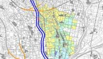
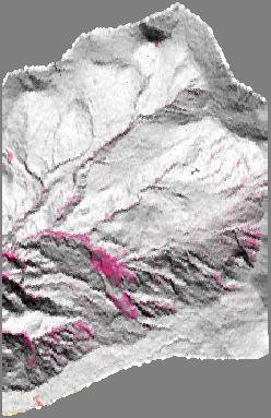

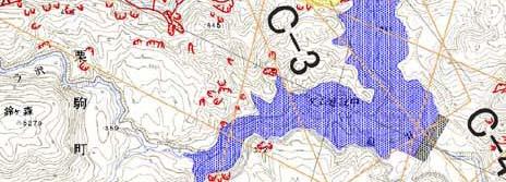
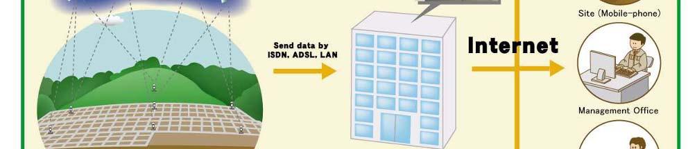

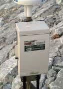
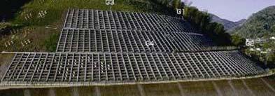
3 Disaster Prevention Business of KKC Measuring & Analyzing topography Extracting landslide Flood Simulation Hazard Map Field Survey Disaster preparedness training Slope Monitoring ASP Service 2


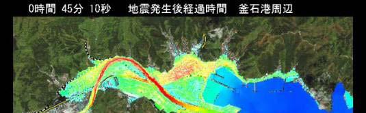
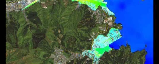
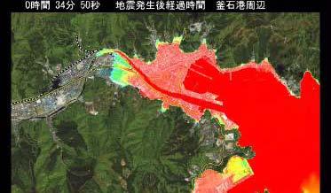
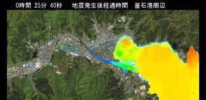
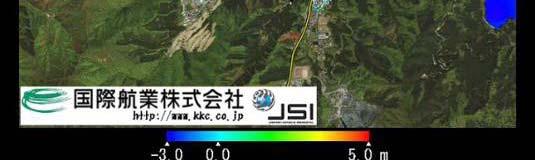
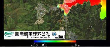
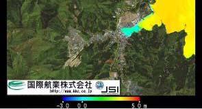
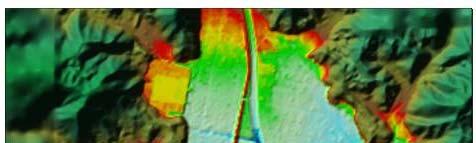
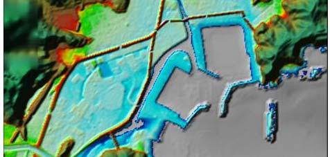
4 Responding to Great East Japan Earthquake in 2011 Oblique aerial photos Comparison of aerial photographs pre- and post-disaster Inundation extent Taken by Kokusai Kogyo Group Pre-disaster ( , 29) Post-disaster ( ) Estimating the extent of inundation using area-wide satellite image CG Simulation of the Tsunami 3


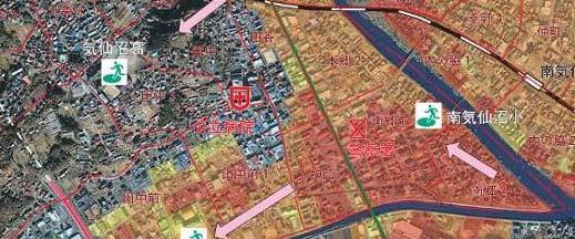
5 sinsai.info (using Ushahidi ) Information with location have been gathered and mapped. Mail Report Government Site Gathered information General information on earthquake Rescue request Evacuation Confirmation of safety Medical treatment support information for the victim 4


6 OpenStreetMap Japan Map situation in 2009 Map situation in May 2011 (2 month after the Earthquake) Provided by Mr. Daichi Foundation Japan 5
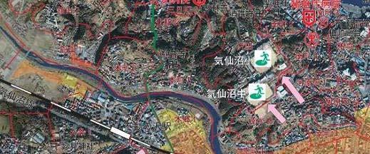
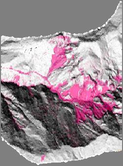
7 OpenStreetMap Japan Inundation area by Tunami Disaster Provided by Mr. Daichi Foundation Japan 6


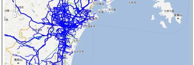
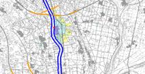
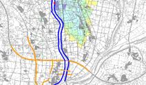
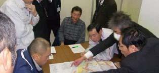
8 Provision of Trafficable Road Information It was difficult for the road administrators to grasp damaged roads for some time after the earthquake. Trafficable road map created by Probe data were useful to transport relief aid. Trafficable Road Map Passed Road Records Passed Road Records 7
9 Public and Private sector Collaboration Car Movement tracked by Auto Makers Passable Roads Closed Road Information provided by Government 8 Presentation by Mr. Hiroshi Murakami
10 Work flow to create Passable Road Map 9
11 Emergency aerial photography survey agreement According to the agreement with GSI (Geospatial Information Authority of Japan) on emergency areal photography survey, aerial photos are taken immediately after the events by Japanese survey companies GSI : Geospatial Information Authority of Japan Request Aerial Photos APA : Association of Precise Survey and Applied Technology Standby notice Aerial Photos Asia Air Survey A-tec Aero Asahi Kokusai Kogyo Hasshu Nakanihon Air Service Pasco Hasshu Pasco Asia Air Survey A-tec Kokusai Kogyo Aero Asahi Taken to complem ment by GS SI Nakanihon Air Service 10
12 Timeline of Response for Agreement March 11th, Friday 14:46 Great East Japan Earthquake 15:30 GSI sends standby notice 15:45 GSI requests APA for list of members 15:54 APA begins contacting member companies 17:59 APA tells GSI: 7 companies ready to respond 22:37 APA tells GSI: 9 companies ready to respond March 12th, Saturday 12:07 GSI reports to APA that this emergency survey job has been divided among 7 companies 11
Preparedness and Rapid Response based on Geospatial Information at Great East Japan Earthquake in 2011
 Preparedness and Rapid Response based on Geospatial Information at Great East Japan Earthquake in 2011 Akira Doi Executive Officer Kokusai Kogyo Co., Ltd. Taken by Kokusai Kogyo UNISDR UNISDR is the United
-News Release- September 7, 2011
 -News Release- September 7, 2011 KOKUSAI KOGYO to release first GIS-based Area Marketing Platform Service for Chinese Market Product supports corporate clients expanding in Chinese market by identifying
Japan Academic Network for Disaster Reduction (JANET-DR) and interdisciplinary collaboration. Science Council of Japan
 and interdisciplinary collaboration. Science Council of Japan") Japan Academic Network for Disaster Reduction (JANET-DR) and interdisciplinary collaboration Members of SCJ and 56 academic societies proceed JANET-DR which covers social sciences, life sciences, natural
Japan Academic Network for Disaster Reduction (JANET-DR) and interdisciplinary collaboration Members of SCJ and 56 academic societies proceed JANET-DR which covers social sciences, life sciences, natural
Table Major analysis products provided by JAXA
 Report on JAXA s Response to the Great East Japan Earthquake - Assistance using earth observation satellites and communication satellites - 2.1.5 Product provision and utilization by users for disaster
EO Contribution to Recovery Activities - A case study on the experience of the Great East Japan Earthquake -
 EO Contribution to Recovery Activities - A case study on the experience of the Great East Japan Earthquake - Michio Ito (Mr.) ito.michio@jaxa.jp Space Applications and Operation Center JAXA Purpose of
PROSPECCIÓN ARQUEOLÓGICA A TRAVÉS DE LIDAR Y ORTOFOTOGRAMETRIA EN EL TAJÍN, VERACRUZ
 PLAN DE MANEJO INTEGRAL DE LA ZONA DE MONUMENTOS RQUEOLOGICOS EL TAJIN PROSPECCIÓN ARQUEOLÓGICA A TRAVÉS DE LIDAR Y ORTOFOTOGRAMETRIA EN EL TAJÍN, VERACRUZ Archaeological Survey through LiDAR and Orthophotogrammetry
Unmanned Aerial Systems for Agriculture
 Unmanned Aerial Systems for Agriculture by Bob Schultheis Natural Resource Engineering Specialist for Greene County Soils & Crops Conference Springfield, MO March 18, 2014 Special thanks to Bill Wiebold,
Lidar Imagery Reveals Maine's Land Surface in Unprecedented Detail
 Maine Geologic Facts and Localities December, 2011 Lidar Imagery Reveals Maine's Land Surface in Unprecedented Detail Text by Woodrow Thompson, Department of Agriculture, Conservation & Forestry 1 Introduction
OUTLINE. About Sendai City Basic Plan for Disaster Management. of Sendai city 3 Actions for Build Back Better
 OUTLINE 1 2 About Sendai City Basic Plan for Disaster Management of Sendai city 3 Actions for Build Back Better About Sendai City Tsunami Land Slide Flooded Areas Floor collapse Major Disaster Affected
Cooperation Program on Creating a Single Concept of Systems, Providing Customized Disaster Management Based on Modern ICT
 2015/SOM1/EPWG/016 Agenda Item: 12 Cooperation Program on Creating a Single Concept of Systems, Providing Customized Disaster Management Based on Modern ICT Purpose: Information Submitted by: Russia 7
Earthquake. 2. MLIT s emergency response to the Great East Japan Earthquake. 3. Recent policy changes regarding tsunami
 1. Damages caused by the Great East Japan Earthquake 2. MLIT s emergency response to the Great East Japan Earthquake 3. Recent policy changes regarding tsunami disaster countermeasures 10 Basic Principles
EO-based services to support humanitarian operations: monitoring population and natural resources in refugee/idp camps
 How satellites can help to save lives Vienna, Austria 23 February 2016 EO-based services to support humanitarian operations: monitoring population and natural resources in refugee/idp camps Petra FÜREDER
Public Safety Management
 Chapter 6: Public Safety Management Disaster prevention Building a more disaster resistant nation Protecting the lives and property of the people from natural disaster is of utmost importance. On the other
RISING PERFORMANCE. Civil aviation is an outlier. It s BY ERIK DAHLBERG
 RISING PERFORMANCE Compact mobile mapping systems can be installed on small passenger cars. Civil aviation is an outlier. It s among the few industries where tight government regulations are widely accepted
THE DESIGN AND IMPLEMENTATION OF A PRACTICAL TSUNAMI EVACUATION DRILL
 THE DESIGN AND IMPLEMENTATION OF A PRACTICAL TSUNAMI EVACUATION DRILL K. TERUMOTO Wakayama University, Japan SUMMARY: Tsunami evacuation measures are now an urgent issue in Japanese coastal area. One of
LAUNCHING YOUR UNMANNED AIRCRAFT PROGRAM
 LAUNCHING YOUR UNMANNED AIRCRAFT PROGRAM THE DARTDRONES TEAM UNMANNED AIRCRAFT APPLICATIONS AERIAL INSPECTIONS AERIAL INSPECTIONS Safer and faster alternative to visual inspection by an individual Damage
Public Safety Management
 Chapter 6: Public Safety Management Disaster Prevention Building a more disaster resistant nation Protecting the lives and property of the people from natural disasters is of the utmost importance. On
Tsunami Survey Results in the NPS and Reproduction Analysis Using Tsunami Inversion
 Technical Workshop on the Accident of TEPCO s Fukushima Dai-ichi NPS Tsunami Survey Results in the NPS and Reproduction Analysis Using Tsunami Inversion July 24, 2012 Tomoyuki Tani Agenda 1. Overview of
Japan Earthquake and Tsunami: a view from satellite data
 Università degli studi di Roma Tor Vergata Corso di Telerilevamento e Cartografia Anno accademico 2012/2013 Japan Earthquake and Tsunami: a view from satellite data Dr. Matteo Picchiani picchiani@disp.uniroma2.it
Regional implementation of Electronic Terrain and Obstacle data (e-tod) (Presented by Jeppesen)
 (Presented by Jeppesen)") International Civil Aviation Organization SAM/IG/13-WP/39 South American Regional Office 5/04/14 Thirteenth Workshop/Meeting of the SAM Implementation Group English only (SAM/IG/13) - Regional Project
International Civil Aviation Organization SAM/IG/13-WP/39 South American Regional Office 5/04/14 Thirteenth Workshop/Meeting of the SAM Implementation Group English only (SAM/IG/13) - Regional Project
AUGUST 2017 GNSS REVIEW. Survey Economics Chances of success. Mobile Mapping Airport scanning. Stag s Leap Winery Pre-construction plan
 AUGUST 2017 GNSS REVIEW Survey Economics Chances of success Stag s Leap Winery Pre-construction plan Mobile Mapping Airport scanning RISING PERFORMANCE» ERIK DAHLBERG Civil aviation is an outlier. It s
Operation Tomodachi and Afterwards A U.S. Marine Corps Perspective Robert D. Eldridge, Ph.D., Deputy Assistant Chief of Staff (G-7), MCIPAC
, MCIPAC") Operation Tomodachi and Afterwards A U.S. Marine Corps Perspective Robert D. Eldridge, Ph.D., Deputy Assistant Chief of Staff (G-7), MCIPAC Marines conducting a moment of silence for victims of the March
Operation Tomodachi and Afterwards A U.S. Marine Corps Perspective Robert D. Eldridge, Ph.D., Deputy Assistant Chief of Staff (G-7), MCIPAC Marines conducting a moment of silence for victims of the March
Figure Pre- and post-disaster satellite topographical maps
 2.1.3 Image analysis by JAXA JAXA conducted ongoing emergency observations using Daichi in the wake of the Great East Japan Earthquake, releasing reporting of its analysis of eastern Japan and Hokkaido
Unmanned Aircraft Systems in Disaster Management and National Preparedness
 Unmanned Aircraft Systems in Disaster Management and National Preparedness at the Hawaii Land Surveyors Association Matt Kobayashi Ted Ralston National Disaster Preparedness Training Center Honolulu Why
Tsunami Propagation Information for Increasing Small Islands Community Preparedness around the Sumatra Island
 Tsunami Propagation Information for Increasing Small Islands Community Preparedness around the Sumatra Island S YA M S ID IK F IR D A U S TEU K U M. R A S YIF TS U N A M I A N D D IS A S TER M ITIG A T
Presentation By. My duties and responsibilities in my country Collection and compilation of disaster related data from different Parts of the kingdom.
 Presentation By POKHAREL Lekh Nath Ministry of Home Affairs,His Majesty's Government of Nepal. Disaster Relief Section Kathmandu NEPAL Now as a visiting Researcher at ADRC. My duties and responsibilities
LOW DOWN ON THE HIGH UP: USING DRONES FOR LAND CONSERVATION
 LOW DOWN ON THE HIGH UP: USING DRONES FOR LAND CONSERVATION TEXAS LAND CONSERVATION CONFERENCE MARCH 3, 2017 STEPHEN RAMIREZ STEWARDSHIP DIRECTOR TEXAS LAND CONSERVANCY RAY RENNER, RPLS, PMP MANAGER OF
COLOMBIAN SPACE COMMISSION: AN STRATEGY FOR THE SUSTAINABLE DEVELOPMENT OF COLOMBIA
 UN Committee on the Peaceful Uses of Outer Space: 2011 - Fifty-fourth fourth session COLOMBIAN SPACE COMMISSION: AN STRATEGY FOR THE SUSTAINABLE DEVELOPMENT OF COLOMBIA Iván n Darío o Gómez G Guzmán General
1. Name: Dr Ravindra K Pande. 2. Designation: Professor of Geography. 5. Research field: Geomorphology, Disaster Management, RS & GIS
 ACADEMIC PROFILE 1. Name: Dr Ravindra K Pande 2. Designation: Professor of Geography 3. Experience: About 38 years 4. Qualification: PhD 5. Research field: Geomorphology, Disaster Management, RS & GIS
The role of Emergency Management Australia with Natural Hazards. Kerryn Vine-Camp
 The role of Emergency Management Australia with Natural Hazards NSW Geography Teachers Association Annual Forum Sydney 26 August 2011 Kerryn Vine-Camp Assistant Secretary, Crisis Coordination Branch Emergency
Papua New Guinea Disaster Risk Reduction Framework
 2018/SOM1/EPWG/014 Agenda Item: 8.2 Papua New Guinea Disaster Risk Reduction Framework Purpose: Information Submitted by: Papua New Guinea 13 th Emergency Preparedness Working Group Meeting Port Moresby,
Investigation on Development of Agricultural Monitoring System Using Satellite Data
 Investigation on Development of Agricultural Monitoring System Using Satellite Data Genya SAITO (1), Daisuke KUNII (1), Naoki ISHITSUKA (2) (1) Tohoku University, 1-1,Tsutsumidori Amamiya-machi Aoba-ku,
Multi Purpose Personal Safety System
 Multi Purpose Personal Safety System People deserve a Choice Survival Capsule LLC is comprised of Aerospace Engineers and a Doctor of Oceanography and Tsunami research (Former member of NOAA). Julian Sharpe
Tsunami Warning in Japan, and Tsunami Advisory for Northwest Pacific and Indian Ocean regions Mitsuyuki Hoshiba
 Tsunami Warning in Japan, and Tsunami Advisory for Northwest Pacific and Indian Ocean regions Mitsuyuki Hoshiba Japan Meteorological Agency (JMA) Contents Tsunami Warning / Advisory in Japan International
Bilateral and regional cooperation good practices of Slovenia
 22nd OSCE Economic and Environmental Forum Responding to environmental challenges with a view to promoting cooperation and security in the OSCE area FIRST PREPARATORY MEETING Vienna, 27-28 January 2014
Partnership Agreement with Hyogo Prefecture Summary. The objectives of the agreement are the effective implementation of international
 Partnership Agreement with Hyogo Prefecture Summary 1. Objectives The objectives of the agreement are the effective implementation of international cooperation in developing regions, the further development
Tsunami Impacting Eastern Japan and Preparedness for Extraordinary Natural Disaster. Takehiko Fujita
 May 25, 2011 Tsunami Impacting Eastern Japan and Preparedness for Extraordinary Natural Disaster Takehiko Fujita Acting President Port and Airport Research Institute, Japan Contents 1. Outline of the earthquake
Restoration and Challenge of Sendai Towards a Disaster-Resilient and Environmentally-Friendly City
 City of Sendai Restoration and Challenge of Sendai Towards a Disaster-Resilient and Environmentally-Friendly City Akira TAKAHASHI akira_takahashi_a@city.sendai.jp Director, Disaster-Resilient and Environmentally-Friendly
Integrated Applications Programme (IAP) & Space for UAS UAS for Applications
 & Space for UAS UAS for Applications") ESA s Integrated Applications Programme (IAP) & Space for UAS UAS for Applications M. Vaissiere ESA Director of Telecommunications and Integrated Applications Programme European High Level UAS Conference
ESA s Integrated Applications Programme (IAP) & Space for UAS UAS for Applications M. Vaissiere ESA Director of Telecommunications and Integrated Applications Programme European High Level UAS Conference
Report on Field Survey of Solomon Islands Earthquake Tsunami in April 2007
 Report on Field Survey of Solomon Islands Earthquake Tsunami in April 2007 by Takashi Tomita 1, Taro Arikawa 2, Daisuke Tatsumi 3, Kazuhiko Honda 3, Hiroshi Higashino 4 Kazuya Watabnabe 4, and Shigeo Takahashi
GREAT EARTHQUAKE DISASTER NILIM, JAPAN
 EAST- JAPAN GREAT EARTHQUAKE DISASTER 11 MARCH in 2011 NILIM, JAPAN CONTENTS 1. Outline of the EARTHQUAKE DISASTER 2. History of EARTHQUAKE/TSUNAMI occurred in Japan 3. Disaster Prevention Policy and Strategy
Great East Japan Earthquake and Tsunami
 Great East Japan Earthquake and Tsunami Kuniyoshi Takeuchi International Centre for Water Hazard and Risk Management under the auspices of UNESCO (ICHARM) Public Works Research Institute (PWRI) Tsukuba,
Post tsunami Recovery of Port and Harbor areas in Japan from the 2011 Great East Japan Earthquake Tsunami
 Date : 18 Nov., 2015 Venue : Furama Ballroom 1 SESSION 1 : A Decade of Partnerships in Sustainable Development of the Seas of East Asia: Synergies and Achievements WORKSHOP 1.1 : Managing Risks in Climate
Japan & JICA s experiences, Risk Governance and/for Resilience and Risk Reduction =The 2nd Arab Conference on DRR=
 Japan & JICA s experiences, Risk Governance and/for Resilience and Risk Reduction =The 2nd Arab Conference on DRR= TAKEYA Kimio Senior Advisor, JICA takeya.kimio@jica.go.jp Japanese Experiences 1 Why Japan
Tremendously heavy rainfall 復旧へ has occurred, twice as much as at any previously recorded time.
 Tremendously heavy rainfall 復旧へ has occurred, twice as much as at any previously recorded time. Emergency warning was issued, 1,000 mm in 24 hours in Asakura, and 600mm in Hita city and then, after rainfall.
IOC Intergovernmental Coordination Group for the Tsunami and Other Coastal Hazards Warning System for the Caribbean and Adjacent Regions
 UNESCO IOC CTIC US NOAA ITIC Regional Training Workshop on Strengthening Tsunami Warning and Emergency Response Standard Operating Procedures and the Development of the ICG/CARIBE-EWS PTWC New Enhanced
By Lusete Laso Mana National Disaster Centre Papua New Guinea
 By Lusete Laso Mana National Disaster Centre Papua New Guinea PRESENTATION OUTLINE A. Brief Country Profile B. Overview of Hazards in PNG C. Overview of National Disaster Centre D. Sentinel Asia PNG Context
Taisei MORISHITA, Hiroaki SAITO and Shin TANI Hydrographic and Oceanographic Department (JHOD) Japan Coast Guard
 Japan Coast Guard") Taisei MORISHITA, Hiroaki SAITO and Shin TANI Hydrographic and Oceanographic Department (JHOD) Japan Coast Guard 1. Earthquake and Tsunami (review) 2. JHOD s Response Activities (overview) 3. Hydrographic
Taisei MORISHITA, Hiroaki SAITO and Shin TANI Hydrographic and Oceanographic Department (JHOD) Japan Coast Guard 1. Earthquake and Tsunami (review) 2. JHOD s Response Activities (overview) 3. Hydrographic
Global UTM Conference UTM Project in Japan. June Hiroyuki Ushijima Ministry of Economy, Trade and Industry (METI)
") Global UTM Conference 2017 UTM Project in Japan June 26 2017 Hiroyuki Ushijima Ministry of Economy, Trade and Industry (METI) Overview 1. UAS Industry in Japan 2. Roadmap of UAS Industry promotion 3. UTM
Global UTM Conference 2017 UTM Project in Japan June 26 2017 Hiroyuki Ushijima Ministry of Economy, Trade and Industry (METI) Overview 1. UAS Industry in Japan 2. Roadmap of UAS Industry promotion 3. UTM
How to Use Drones in Stormwater Management January 17, :30 a.m. 11:30 a.m. (Eastern)
") Webinar Training Series How to Use Drones in Stormwater Management January 17, 2019 10:30 a.m. 11:30 a.m. (Eastern) www.seswa.org Today s Presenters Robert Gecy Application Programmer Beaufort County,
Webinar Training Series How to Use Drones in Stormwater Management January 17, 2019 10:30 a.m. 11:30 a.m. (Eastern) www.seswa.org Today s Presenters Robert Gecy Application Programmer Beaufort County,
2018/SOM3/EPWG/007 Agenda Item: Tari Earthquake. Purpose: Information Submitted by: Papua New Guinea
 2018/SOM3/EPWG/007 Agenda Item: 10.13 Tari Earthquake Purpose: Information Submitted by: Papua New Guinea 14 th Emergency Preparedness Working Group Meeting Port Moresby, Papua New Guinea 10 11 August
Establishment of APEC Emergency Preparedness. Working Group and its recent development
 Sistema Económico Latinoamericano y del Caribe Latin American and Caribbean Economic System Sistema Econômico Latino-Americano e do Caribe Système Economique Latinoaméricain et Caribéen Establishment of
Glacial Lake Outburst Flood Mitigation Measures, Monitoring and Early Warning Systems
 Chapter 12 Glacial Lake Outburst Flood Mitigation Measures, Monitoring and Early Warning Systems There are several possible methods for mitigating the impact of Glacial Lake Outburst Flood (GLOF) surges,
IOC/UNESCO Bulletin No. 8 As of 23 March 2011
 IOC/UNESCO Bulletin No. 8 As of 23 March 2011 Casualties by the Earthquake and Tsunami As of 06:00z 23 Mar 2011 The National Police Agency Dead: 9,452 Missing: 14,715 Road destruction: 1,749 Bridge destruction:
The American Institute of Aeronautics and Astronautics
 The American Institute of Aeronautics and Astronautics Civilian Applications of UAVs A California Perspective, a Policy Symposium Michael Toscano President & CEO Association for Unmanned Vehicle Systems
Procedia - Social and Behavioral Sciences 216 ( 2016 )
") Available online at www.sciencedirect.com ScienceDirect Procedia - Social and Behavioral Sciences 216 ( 2016 ) 481 491 Urban Planning and Architecture Design for Sustainable Development, UPADSD 14-16 October
Available online at www.sciencedirect.com ScienceDirect Procedia - Social and Behavioral Sciences 216 ( 2016 ) 481 491 Urban Planning and Architecture Design for Sustainable Development, UPADSD 14-16 October
Operation of Evacuation Center and Support for non-japanese
 Operation of Evacuation Center and Support for non-japanese 1. The International Center as an evacuation center 2. Non-Japanese residents of Kumamoto City 3. Details of activities after Kumamoto earthquake
the high fatalities inflicted by the earthquake
 2011.10.25 The 2011 off the Pacific Coast of Tohoku earthquake Interviewing insights regarding the high fatalities inflicted by the earthquake Masataka Ando 1, Mizuho Ishida 2, Yoshinari Hayashi 3 and
GEOSPATIAL ANALYSIS OF GLACIAL HAZARDS PRONE AREAS OF SHIGAR AND SHAYOK BASINS OF PAKISTAN. By Syed Naseem Abbas Gilany
 GEOSPATIAL ANALYSIS OF GLACIAL HAZARDS PRONE AREAS OF SHIGAR AND SHAYOK BASINS OF PAKISTAN By Syed Naseem Abbas Gilany PRESENTATION OUTLINE Introduction Problem Statement / Rationale Objectives Material
16 July 07 M w 6.6 Niigata ken Chuetsu Oki Earthquake 平成 19 年 (2007 年 ) 新潟県中越沖地震
 新潟県中越沖地震") 16 July 07 M w 6.6 Niigata ken Chuetsu Oki Earthquake 平成 19 年 (2007 年 ) 新潟県中越沖地震 Charles Scawthorn, S.E. Professor of Lifeline Engineering Head, Earthquake Disaster Prevention Laboratory Department of
16 July 07 M w 6.6 Niigata ken Chuetsu Oki Earthquake 平成 19 年 (2007 年 ) 新潟県中越沖地震 Charles Scawthorn, S.E. Professor of Lifeline Engineering Head, Earthquake Disaster Prevention Laboratory Department of
Building Preparedness Capacity for Community Emergency Response and Disaster Mitigation. International Disaster and Risk Conference IDRC 2008
 Building Preparedness Capacity for Community Emergency Response and Disaster Mitigation International Disaster and Risk Conference IDRC 2008 Disaster Incidents in Latin America Over the Last 2-½ Years
DRONING FOR INFORMATION
 DRONING FOR INFORMATION Opportunity of Drones for Surveying and Mapping Practices By: Adam Smith, CP Matt Aguirre, PLS Overview Introduction Background Problem and Opportunity Issues and Mitigations Implementation
Typhoon Isewan and Its Lessons
 Typhoon Isewan and Its Lessons March 21, 2006 Kenji SUZUKI Japan Water Forum In 1959, Typhoon Isewan hit Central Japan and caused the worst damage, due to high tides and floods. Nagoya Typhoon Isewan courses
Ground Deformation Monitoring at Natural Gas Production Sites using Interferometric SAR
 Ground Deformation Monitoring at Natural Gas Production Sites using Interferometric SAR By: Kanika Goel, Robert Shau, Fernando Rodriguez Gonzalez, Nico Adam Remote Sensing Technology Institute (IMF), German
KNOWLEDGE NOTE 1-3. Hydro-meteorological Disasters Associated with Tsunamis and Earthquakes. CLUSTER 1: Structural Measures
 Public Disclosure Authorized Public Disclosure Authorized Public Disclosure Authorized Public Disclosure Authorized KNOWLEDGE NOTE 1-3 CLUSTER 1: Structural Measures Hydro-meteorological Disasters Associated
THE REAPPEARANCE OF THE DANTON
 THE REAPPEARANCE OF THE DANTON MV Geo Prospector Operations In December 2007, the Fugro survey vessel Geo Prospector was performing part of the Detailed Marine Survey for routing the proposed Galsi gas
UAS to GIS Utilizing a low-cost Unmanned Aerial System (UAS) for Coastal Erosion Monitoring
 for Coastal Erosion Monitoring") UAS to GIS Utilizing a low-cost Unmanned Aerial System (UAS) for Coastal Erosion Monitoring Agenda Scope of today s presentation Demonstration Objectives Wrightsville Beach Test Area Masonboro Inlet Jetties
UAS to GIS Utilizing a low-cost Unmanned Aerial System (UAS) for Coastal Erosion Monitoring Agenda Scope of today s presentation Demonstration Objectives Wrightsville Beach Test Area Masonboro Inlet Jetties
Proposal of constructing new tsunami shelter buildings at Mimase in Kochi City
 Proposal of constructing new tsunami shelter buildings at Mimase in Kochi City Hiroyuki KITAMOTO Mimasaka University, Tsuyama, Japan Michio MIYANO Osaka City University, Osaka, Japan Sayumi HAGINO Miyajidenki
Disaster Risk Management in Tourism Destinations
 Disaster Risk Management in Tourism Destinations Dr. Stefanos Fotiou United Nations Environment Programme Division of Technology, Industry and Economics This presentation is about Tourism and Risk Tourism
Population Composition, Geographic Distribution, and Natural Hazards: Vulnerability in the Coastal Regions of Puerto Rico
 Population Composition, Geographic Distribution, and Natural Hazards: Vulnerability in the Coastal Regions of Puerto Rico Researchers Havidán Rodríguez, Ph.D. (DRC-UDel) Walter Díaz, Ph. D. (CISA-UPRM)
WMO :Regional Consultation on Climate Services For Indian Ocean Islands. Mauritius March, 2016 RIMES Contribution
 WMO :Regional Consultation on Climate Services For Indian Ocean Islands Mauritius 14-16 March, 2016 RIMES Contribution Structure of Presentation RIMES Introduction. Type of Climate Products and Services
Drone Technology: What Works for Industry & Landowners. Michael J. Buschermohle Interim Assistant Dean UT Extension
 Drone Technology: What Works for Industry & Landowners Michael J. Buschermohle Interim Assistant Dean UT Extension So You Want to Fly FAA Regulations UAS Platforms Cameras Applications in Forestry Current
2017 TIAS Study Tour (Rikuzentakata City, Iwate Prefecture / Iitate Village, Fukushima Prefecture)
") 2017 TIAS Study Tour (Rikuzentakata City, Iwate Prefecture / Iitate Village, Fukushima Prefecture) 1. Itinerary From 1 st November to 3 rd November 2017 / 3 days 2. Participant TIAS professors, researchers,
2017 TIAS Study Tour (Rikuzentakata City, Iwate Prefecture / Iitate Village, Fukushima Prefecture) 1. Itinerary From 1 st November to 3 rd November 2017 / 3 days 2. Participant TIAS professors, researchers,
Thanks to the efforts of so many people and their support including that of international society, reconstruction is moving steadily ahead.
 Minister Yoshino s Keynote Speech at the Luncheon Plenary of the U.S.-Japan Council Annual Conference Reconstruction from the Great East Japan Earthquake (November 13, 2017, Washington DC) Ladies and gentlemen,
Tsunami Evacuation Process and Human Loss Distribution in the 2011 Great East Japan Earthquake - A Case Study of Natori City, Miyagi Prefecture -
 Tsunami Evacuation Process and Human Loss Distribution in the 2011 Great East Japan Earthquake - A Case Study of Natori City, Miyagi Prefecture - H. Murakami, K. Takimoto Graduate School of Science and
Trail Assessment Report
 Trail Assessment Report Trail Options for the Bear Creek Canyon located in Pikes Peak Ranger District, Pike National Forest and on Colorado Springs Utility Lands Due to the presence of a unique species
TWENTY-SECOND MEETING OF THE ASIA/PACIFIC AIR NAVIGATION PLANNING AND IMPLEMENTATION REGIONAL GROUP (APANPIRG/22)
") INTERNATIONAL CIVIL AVIATION ORGANIZATION TWENTY-SECOND MEETING OF THE ASIA/PACIFIC AIR NAVIGATION PLANNING AND IMPLEMENTATION REGIONAL GROUP (APANPIRG/22) Bangkok, Thailand, 5-9 September 2011 Agenda
INTERNATIONAL CIVIL AVIATION ORGANIZATION TWENTY-SECOND MEETING OF THE ASIA/PACIFIC AIR NAVIGATION PLANNING AND IMPLEMENTATION REGIONAL GROUP (APANPIRG/22) Bangkok, Thailand, 5-9 September 2011 Agenda
Queensland Reconstruction Authority Rebuilding a stronger, more resilient Queensland
 Queensland Reconstruction Authority Rebuilding a stronger, more resilient Queensland The capacity to prepare for, withstand, respond to and recover from disasters The capacity to prepare for, withstand,
University of Connecticut Division of Student Affairs Unit Review. What is Unit Review? Purpose. Guiding Principles of Unit Review
 University of Connecticut Division of Student Affairs Unit Review What is Unit Review? Unit review is a collaborative process designed to provide an in-depth, comprehensive study of a unit/department.
3-D GIS Applications in Aviation and Aerospace Pedagogy Dr. Rich Snow, Dr. Mary Snow, and Mario Westphal. Abstract
 3-D GIS Applications in Aviation and Aerospace Pedagogy Dr. Rich Snow, Dr. Mary Snow, and Mario Westphal Abstract Embry-Riddle Aeronautical University s new GIS Applications Lab has developed a 3-D airspace
The Potentially Dangerous Glacial Lakes
 Chapter 11 The Potentially Dangerous Glacial Lakes On the basis of actively retreating glaciers and other criteria, the potentially dangerous glacial lakes were identified using the spatial and attribute
Operators may need to retrofit their airplanes to ensure existing fleets are properly equipped for RNP operations. aero quarterly qtr_04 11
 Operators may need to retrofit their airplanes to ensure existing fleets are properly equipped for RNP operations. 24 equipping a Fleet for required Navigation Performance required navigation performance
Tsunami Standard Operating Procedures. For the Turks and Caicos Islands
 Tsunami Standard Operating Procedures For the Turks and Caicos Islands Objectives Setting the context Existing system in place 1. Tsunami Warning Communications Testing 2. Capacity Building 3. USGS Seismic
ANNUAL REPORT: ANCIENT METHONE ARCHAEOLOGICAL PROJECT 2014 FIELD SCHOOL
 ANNUAL REPORT: ANCIENT METHONE ARCHAEOLOGICAL PROJECT 2014 FIELD SCHOOL Director(s): Co- Director(s): Professor Sarah Morris, Cotsen Institute of Archaeology, UCLA John K. Papadopoulos, Cotsen Institute
Ports. Water and Environment Solutions
 Ports Water and Environment Solutions BMT WBM in Ports The Company BMT WBM and Ports BMT WBM Pty Ltd is a leading edge water and environmental consultancy with more than 40 years national and international
NASA s Automatic Dependent Surveillance Broadcast: ADS-B Sense-and-Avoid System
 NASA s Automatic Dependent Surveillance Broadcast: ADS-B Sense-and-Avoid System October 30, 2014 Ricardo Arteaga NASA Armstrong Flight Research Center is a world class leader in cutting-edge Systems Engineer
Preparing for a Natural Disaster. Battalion Chief Mike Finnerty San Diego California Fire-Rescue Department
 Preparing for a Natural Disaster Battalion Chief Mike Finnerty San Diego California Fire-Rescue Department Battalion Chief for San Diego Fire Rescue in San Diego, California Firefighter 40+ years San Diego
TPA Emergency Planning and Response
 TPA Emergency Planning and Response Tampa Bay Area Contingency Planners Agenda Airport Emergency Planning Federal Aviation Regulations Plans and Procedures Airport Emergency Plan Hurricane Plan Wildlife
USE OF 3D GIS IN ANALYSIS OF AIRSPACE OBSTRUCTIONS
 USE OF 3D GIS IN ANALYSIS OF AIRSPACE OBSTRUCTIONS A project by by Samuka D. W. F19/1461/2010 Supervisor; Dr D. N. Siriba 1 Background and Problem Statement The Airports in Kenya are the main link between
Letter to editor Field study in Hokkaido Prefecture after the 2018 Hokkaido Eastern Iburi Earthquake
 Letter to editor Field study in Hokkaido Prefecture after the 2018 Hokkaido Eastern Iburi Earthquake 1 / 5 Youichi Yanagawa, MD, PhD., Hiroki Nagasawa MD., Ikuto Takeuchi MD., Kei Jitsuiki MD., Shunsuke
Photos courtesy of the Japanese Ministry of Foreign Affairs: Flooding at Sendai International Airport
 Dear Friends, I. Sendai International Airport On March 11 th Japan was struck by a three-fold disaster causing the loss of nearly 20,000 lives. In the following days and weeks, 19,703 members of the US
Population Movement in the Tohoku Region after the Great East Japan Earthquake Disaster
 83 Population Movement in the Tohoku Region after the Great East Japan Earthquake Disaster Takashi ABE Abstract This paper clarifies the demographic change in the Tohoku Region after the Great East Japan
Event Report 8th IPA Press-in Engineering Seminar in Kochi 2015
 Event Report 8th IPA Press-in Engineering Seminar in Kochi 2015 The 8th IPA Press-in Engineering Seminar was held on Tuesday 14th July, 2015 in Kochi. This year s seminar was divided into two parts. In
REPORT OF STUDY TRIP (Niigata & Miyagi Prefectures)
") INTERNATIONAL INSTITUTE OF SEISMOLOGY AND EARTHQUAKE ENGINEERING (IISEE) REPORT OF STUDY TRIP (Niigata & Miyagi Prefectures) 14 17 November 2011 Prepared by: Biana Rahayu Wulandari S course (Indonesia)
INTERNATIONAL INSTITUTE OF SEISMOLOGY AND EARTHQUAKE ENGINEERING (IISEE) REPORT OF STUDY TRIP (Niigata & Miyagi Prefectures) 14 17 November 2011 Prepared by: Biana Rahayu Wulandari S course (Indonesia)
The 2nd Glacier Inventory of China
 The 2nd Glacier Inventory of China LIU Shiyin Guo Wanqin, Xu Junli, Shangguan Donghui, Wei Junfeng, Wu Lizong, Yu Pengchun, Li Jing, Liu Qiao State Key Laboratory of Cryospheric Sciences, Cold and Arid
UNMANNED AIRCRAFT SYSTEMS (UAS) IN UTILITIES
 IN UTILITIES") UNMANNED AIRCRAFT SYSTEMS (UAS) IN UTILITIES Presented by: Dan Carbone Avion Unmanned Why Drones? Why Drones? Cost Effective Entire cost of a UAS program can be recouped in first-year man-hour savings
UNMANNED AIRCRAFT SYSTEMS (UAS) IN UTILITIES Presented by: Dan Carbone Avion Unmanned Why Drones? Why Drones? Cost Effective Entire cost of a UAS program can be recouped in first-year man-hour savings
GRANDE News Letter Volume1, No.4, March 2013
 GRANDE News Letter Volume1, No.4, March 2013 New technologies for the study of tropical glaciers Prof. Edson RAMIREZ Institute of Hydraulics and Hydrology, Universidad Mayor de San Andres, Bolivia Techniques
The Event: once in 1,000 years
 East Japan Earthquake and Tsunami: Post disaster Issues and Challenges http://www.dailymail.co.uk Rajib Shaw http://www.iedm.ges.kyoto u.ac.jp/ t / http://www.dailymail.co.uk The Event: once in 1,000 years
Response to Tsunami Disaster -the Great East Japan Earthquake 2011-
 Response to Tsunami Disaster -the Great East Japan Earthquake 2011- JAPAN COAST GUARD Hydrographic and Oceanographic Department (JHOD) Outline I. Response to Tsunami Disaster 2011 II. International meeting
GEOMATIC ASSESSMENT Membership Directory & Buyers Guide 97th Annual Conference Recap WINTER 2017/18
 WINTER 2017/18 GEOMATIC NC AWWA-WEA 3725 National Drive, Suite 217 Raleigh, NC 27612 ADDRESS SERVICE REQUESTED 2018 Membership Directory & Buyers Guide 97th Annual Conference Recap The official publication