The 2nd Glacier Inventory of China
|
|
|
- Blaze Newton
- 5 years ago
- Views:
Transcription
1 The 2nd Glacier Inventory of China LIU Shiyin Guo Wanqin, Xu Junli, Shangguan Donghui, Wei Junfeng, Wu Lizong, Yu Pengchun, Li Jing, Liu Qiao State Key Laboratory of Cryospheric Sciences, Cold and Arid Regions Engineering Research Institute, CAS

2 1. Background 5A: Ob River 5J: Yellow River 5K: Yangtze River 5L: Mekong River 5N: Salween River 5O: Ganges River 5Q: Indus River 5X: Central Asia Region 5Y: Eastern Asia Interior Region 5Z: Qinghai-Tibetan Interior Region Glaciers: 46377, km2 and km3 in western China (Shi et al., 2008)
3 Statistics of glacier number, area and volume in different mountains in China: Glaciers in Tianshan, Kunlun, Nyainqentanglha and Himalaya take 68.3% of total glacier area in China
4 Meltwater contribution to the total runoff of different rivers (left panel) and that in surface runoff of 4 west provinces (right panel) (all in %)
5 (% of numbers) distribution of various glacier area classes in China: 95.8% glaciers are smaller than 5.0km2. They only takes about 49% of the total area of glaciers in China
6 Small glaciers may play an important role in the changes of glacier area and the impact on water availability and glacier hazards
7 2. Data and Method for the 2nd GIC ASTER Landsat TM/ETM+ GDEM ASTER Landsat TM/ETM+ Year Numbers Year Number Number (TM) Total 563 Total

8 ASTER scenes used in Second Glacier Inventory of China Totally 563 ASTER imageries were orthorectified.

9 Landsat TM/ETM+ used in Second Glacier Inventory of China Totally 119 Landsat TM/ETM+ imageries were used.

10 ASTER GDEM used in Second Glacier Inventory of China Totally 265 GDEM data were used.
11 Clean-ice glacier outline extraction Band ratio thresholding methods Landsat TM: band 2/band 5, with reference on band 3/band 5 ASTER: band 1/band 4, with reference on band 2/band 4
12 Ice divides extraction Glacier central flow line extraction Glacier attributes calculation method Glacier midflow lines Binary tree search with reference on line length Find glacier label point on primary mid-flow line in firn basin Retrieve point coordinates in lattitude/longitude Extract terminal point of glacier Glacier boundaries ASTER DEM Build polygon topology Retrieve DEM cells in glacier polygon Calculate statistics Glacier code Calculate slope and aspect Median area elevation of glacier Terminal elevation of glacier Glacier length Retrieve half area elevation Glacier area Glacier perimeters Maximum elevation of glacier Average elevation of glacier Glacier slope Glacier orientation


13 Accuracy assessment Accuracy of clean-ice glacier outlines Comparon with field GPS measurements, mean positioning error: ±38 m Comparison with multiexpert judgments, mean positioning accuracy: ±35.2 m Automatically extracted glacier outlines validated with field GPS measurements Assessment for errors from visual interpretation based on different interpreters


14 Area error from satellite images is defined λl is the resolution of image scenes n is the total number of pixels along the outline of a glacier polygon excluding the common ridge line of the mountain. Uncertainty distribution for glaciers in the 4th level watershed
15 3. Result ~85% in area of glaciers were compiled with se cond inventory in western China. The remaining part is mainly located in the so utheast Tibetan Plateau, where very few fine q uality remote sensing imageries are available.
16 Glaciers with the second inventory in China Glacier central flow line extraction Glacier attributes calculation method
17 The present total glacier area in various mountains of China (glaciers without 2nd inventory are substituted with dtat of 1st GIC) Mountains Altai Sawuer Tianshan Pamir Karakoram Kunlun Aktun Qilian Qiangtang Tanggula Gandise Nyainqentanglha Hengduan Himalaya Total Area %
18 Glacier changes in China Basin Code First Glacier Inventory Area (km2) Year Second Glacier Inventory Area (km2) Glacier Change Year Overall(%) 5A J K L N O Q X Y Z Total
19

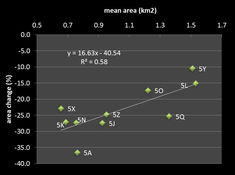
20 Annual mean shrinkage rate: (Sscd/Sfst)(1/n)-1 Sscd and Sfst are areas of the second and first time inventories; n: years between the two time inventories The spatial pattern of glacier area reduction in China: glaciers in central Tibetan Plateat have been generally in smaller area shrinkage
21 Summary Glaciers in ~2010 in China might have a total area of km2 In the last 60 yrs, glaciers in China have lost 18.7% of their area in late 1950s. The spatial pattern glacier areal Shrinkage may be controlled by the physical properties of glaciers.
22 Thank you for your attention!
The second Chinese glacier inventory: data, methods and results
 Journal of Glaciology, Vol. 61, No. 226, 2015 doi: 10.3189/2015JoG14J209 357 The second Chinese glacier inventory: data, methods and results Wanqin GUO, 1 Shiyin LIU, 1 Junli XU, 1 Lizong WU, 2 Donghui
Assessment of glacier water resources based on the Glacier Inventory of China
 104 Annals of Glaciology 50(53) 2009 Assessment of glacier water resources based on the Glacier Inventory of China KANG Ersi, LIU Chaohai, XIE Zichu, LI Xin, SHEN Yongping Cold and Arid Regions Environmental
Glacier retreat as a result of climate warming and increased precipitation in the Tarim river basin, northwest China
 Annals of Glaciology 43 2006 91 Glacier retreat as a result of climate warming and increased precipitation in the Tarim river basin, northwest China LIU Shiyin, 1,2 DING Yongjian, 1 SHANGGUAN Donghui,
The retreat of glaciers in response to recent climate warming in western China
 Annals of Glaciology 43 2006 97 The retreat of glaciers in response to recent climate warming in western China DING Yongjian, 1 LIU Shiyin, 1,2 LI Jing, 1 SHANGGUAN Donghui 1 1 Key Laboratory of Cryosphere
Observation of cryosphere
 Observation of cryosphere By Sagar Ratna Bajracharya (email: sagar.bajracharya@icimod.org) Samjwal Ratna Bajracharya Arun Bhakta Shrestha International Centre for Integrated Mountain Development Kathmandu,
EVALUATION OF DIFFERENT METHODS FOR GLACIER MAPPING USING LANDSAT TM
 EVALUATION OF DIFFERENT METHODS FOR GLACIER MAPPING USING LANDSAT TM Frank Paul Department of Geography, University of Zurich, Switzerland Winterthurer Strasse 190, 8057 Zürich E-mail: fpaul@geo.unizh.ch,
Retreating Glaciers of the Himalayas: A Case Study of Gangotri Glacier Using Satellite Images
 Retreating Glaciers of the Himalayas: A Case Study of Gangotri Glacier Using 1990-2009 Satellite Images Jennifer Ding Texas Academy of Mathematics and Science (TAMS) Mentor: Dr. Pinliang Dong Department
Glacier change over the past four decades in the middle Chinese Tien Shan
 Journal of Glaciology, Vol. 52, No. 178, 2006 425 Glacier change over the past four decades in the middle Chinese Tien Shan Baolin LI, 1 A-Xing ZHU, 1,2 Yichi ZHANG, 1 Tao PEI, 1 Chengzhi QIN, 1 Chenghu
Rapid decrease of mass balance observed in the Xiao (Lesser) Dongkemadi Glacier, in the central Tibetan Plateau
 Dongkemadi Glacier, in the central Tibetan Plateau") HYDROLOGICAL PROCESSES Hydrol. Process. 22, 2953 2958 (2008) Published online 8 October 2007 in Wiley InterScience (www.interscience.wiley.com).6865 Rapid decrease of mass balance observed in the Xiao
HYDROLOGICAL PROCESSES Hydrol. Process. 22, 2953 2958 (2008) Published online 8 October 2007 in Wiley InterScience (www.interscience.wiley.com).6865 Rapid decrease of mass balance observed in the Xiao
The Role of Glaciers in the Hydrologic Regime of the Nepal Himalaya. Donald Alford Richard Armstrong NSIDC Adina Racoviteanu NSIDC
 The Role of Glaciers in the Hydrologic Regime of the Nepal Himalaya Donald Alford Richard Armstrong NSIDC Adina Racoviteanu NSIDC Outline of the talk Study area and data bases Area altitude distributed
SUPPLEMENTARY INFORMATION
 In the format provided by the authors and unedited. Here we provide supplementary information about: - ASTER mass balance spatial coverage DOI: 10.1038/NGEO2999 A spatially resolved estimate of High Mountain
Glacial lakes as sentinels of climate change in Central Himalaya, Nepal
 Glacial lakes as sentinels of climate change in Central Himalaya, Nepal Sudeep Thakuri 1,2,3, Franco Salerno 1,3, Claudio Smiraglia 2,3, Carlo D Agata 2,3, Gaetano Viviano 1,3, Emanuela C. Manfredi 1,3,
Remote-sensing estimate of glacier mass balance over the central. Nyainqentanglha Range during 1968 ~2013
 0 Remote-sensing estimate of glacier mass balance over the central Nyainqentanglha Range during ~0 Kunpeng Wu, *, Shiyin Liu, *, Zongli Jiang, Junli Xu, Junfeng Wei School of Resources and Environment,
Dynamic response of glaciers of the Tibetan Plateau to climate change
 Christoph Schneider 1/23 Christoph Schneider Yao, Tandong Manfred Buchroithner Tobias Bolch Kang, Shichang Dieter Scherer Yang, Wei Fabien Maussion Eva Huintjes Tobias Sauter Anwesha Bhattacharya Tino
A high resolution glacier model with debris effects in Bhutan Himalaya. Orie SASAKI Kanae Laboratory 2018/02/08 (Thu)
") A high resolution glacier model with debris effects in Bhutan Himalaya Orie SASAKI Kanae Laboratory 2018/02/08 (Thu) Research flow Multiple climate data at high elevations Precipitation, air temperature
A high resolution glacier model with debris effects in Bhutan Himalaya Orie SASAKI Kanae Laboratory 2018/02/08 (Thu) Research flow Multiple climate data at high elevations Precipitation, air temperature
Causes of glacier change in the source regions of the Yangtze and Yellow rivers on the Tibetan Plateau
 Journal of Glaciology, Vol. 49, No. 167, 2003 Causes of glacier change in the source regions of the Yangtze and Yellow rivers on the Tibetan Plateau YANG Jianping, DING Yongjian, CHEN Rensheng, LIU Shiyin,
Compiling a new glacier inventory for southeastern Qinghai Tibet Plateau from Landsat and PALSAR data
 Journal of Glaciology (2016), Page 1 of 14 doi: 10.1017/jog.2016.58 The Author(s) 2016. This is an Open Access article, distributed under the terms of the Creative Commons Attribution licence (http://creativecommons.
Robson Valley Avalanche Tract Mapping Project
 Robson Valley Avalanche Tract Mapping Project Prepared for: Chris Ritchie Ministry of Water Land and Air Protection 325 1011 4th Avenue Prince George, BC. V2L3H9 and Dale Seip Ministry of Forests 1011
Using of space technologies for glacierand snow- related hazards studies
 United Nations / Germany international conference on International Cooperation Towards Low-Emission and Resilient Societies Using of space technologies for glacierand snow- related hazards studies Bonn,
GEOSPATIAL ANALYSIS OF GLACIAL HAZARDS PRONE AREAS OF SHIGAR AND SHAYOK BASINS OF PAKISTAN. By Syed Naseem Abbas Gilany
 GEOSPATIAL ANALYSIS OF GLACIAL HAZARDS PRONE AREAS OF SHIGAR AND SHAYOK BASINS OF PAKISTAN By Syed Naseem Abbas Gilany PRESENTATION OUTLINE Introduction Problem Statement / Rationale Objectives Material
SUPPLEMENTARY INFORMATION
 SUPPLEMENTARY INFORMATION doi: 10.1038/ngeo1122 Global sea-level contribution from the Patagonian Icefields since the Little Ice Age maximum Methods Error Assessment Supplementary Figures 1 and 2 Supplementary
Integration Of Reflectance To Study Glacier Surface Using Landsat 7 ETM+: A Case Study Of The Petermann Glacier In Greenland
 Integration Of Reflectance To Study Glacier Surface Using Landsat 7 ETM+: A Case Study Of The Petermann Glacier In Greenland Félix O. Rivera Santiago Department Of Geology, University Of Puerto Rico, Mayaguez
Glacier changes in the Koshi River basin, central Himalaya, from 1976 to 2009, derived from remote-sensing imagery
 Annals of Glaciology 55(66) 2014 doi: 10.3189/2014AoG66A057 61 Glacier changes in the Koshi River basin, central Himalaya, from 1976 to 2009, derived from remote-sensing imagery SHANGGUAN Donghui, 1,3
ENSC454 Snow and Ice: Glaciers April Roger Wheate (NRES)
") ENSC454 Snow and Ice: Glaciers April 1 2015 Roger Wheate (NRES) Roger.Wheate@unbc.ca Sólheimajökull, Iceland The main purpose of snow: it makes glaciers April 1 other uses of snow April 1 uses of glaciers:
ENSC454 Snow and Ice: Glaciers April 1 2015 Roger Wheate (NRES) Roger.Wheate@unbc.ca Sólheimajökull, Iceland The main purpose of snow: it makes glaciers April 1 other uses of snow April 1 uses of glaciers:
INTERNATIONAL WORKSHOP ON WORLD GLACIER INVENTORY Lanzhou, China September 2008
 INTERNATIONAL WORKSHOP ON WORLD GLACIER INVENTORY Lanzhou, China 20-24 September 2008 PRELIMINARY PROGRAMME Saturday 20 September 0 15:00 Arrival and Registration at Ningwozhuang Hotel 1 19:00 Icebreaker
Monitoring of Mountain Glacial Variations in Northern Pakistan, from 1992 to 2008 using Landsat and ALOS Data. R. Jilani, M.Haq, A.
 Monitoring of Mountain Glacial Variations in Northern Pakistan, from 1992 to 2008 using Landsat and ALOS Data R. Jilani, M.Haq, A. Naseer Pakistan Space & Upper Atmosphere Research Commission (SUPARCO)
Snow, Glacier and GLOF
 Snow, Glacier and GLOF & Report on Demonstration River Basin Activities Upper Indus Basin The 5th International Coordination Group (ICG) Meeting GEOSS Asian Water Cycle Initiative (AWCI) Tokyo, Japan,
Recent glacial retreat and its effect on water resources in eastern Xinjiang
 Article Geography November 2011 Vol.56 No.33: 3596 3604 doi: 10.1007/s11434-011-4720-8 Recent glacial retreat and its effect on water resources in eastern Xinjiang LI KaiMing 1,2*, LI ZhongQin 1,3, GAO
Glacier shrinkage in the Ebinur lake basin, Tien Shan, China, during the past 40 years
 Journal of Glaciology, Vol. 60, No. 220, 2014 doi: 10.3189/2014JoG13J023 245 Glacier shrinkage in the Ebinur lake basin, Tien Shan, China, during the past 40 years Lin WANG, 1 Zhongqin LI, 1 Feiteng WANG,
Impacts of climate change on the hydrological processes in the Mekong River. Hui Lu & Wei Wang Tsinghua University
 1 Impacts of climate change on the hydrological processes in the Mekong River Hui Lu & Wei Wang Tsinghua University Outline Backgrounds Method and data Model calibration Temperature and rainfall trends
The SHARE contribution to the knowledge of the HKKH glaciers, the largest ice masses of our planet outside the polar regions
 The SHARE contribution to the knowledge of the HKKH glaciers, the largest ice masses of our planet outside the polar regions Claudio Smiraglia 1 with the collaboration of Guglielmina Diolaiuti 1 Christoph
Community resources management implications of HKH hydrological response to climate variability
 Community resources management implications of HKH hydrological response to climate variability -- presented by N. Forsythe on behalf of: H.J. Fowler, C.G. Kilsby, S. Blenkinsop, G.M. O Donnell (Newcastle
A GEOGRAPHIC ANALYSIS OF OPTIMAL SIGNAGE LOCATION SELECTION IN SCENIC AREA
 A GEOGRAPHIC ANALYSIS OF OPTIMAL SIGNAGE LOCATION SELECTION IN SCENIC AREA Ling Ruan a,b,c, Ying Long a,b,c, Ling Zhang a,b,c, Xiao Ling Wu a,b,c a School of Geography Science, Nanjing Normal University,
Habitat of Large Glaciers and Snow Leopards
 Headwaters of High Mountain Asia - Habitat of Large Glaciers and Snow Leopards International Snow Leopard Day A Collaborative Effort to Assess the Role of Glaciers and Seasonal Snow Cover in the Hydrology
Note that the steepest 8 direction pour point model slope in direction 64 is: 10.0
 GIS in Water Resources Exercise #3 Solution Part 1. 1.1 Hand Calculations (i) The standard ESRI surface slope function Grid size 10 m Diagonal distance= 14.142 m 47.5 48 47.7 50.6 48.3 dz/dx= -0.125 45.1
Quantification of glacier melt volume in the Indus River watershed
 Brigham Young University BYU ScholarsArchive All Theses and Dissertations 2011-12-07 Quantification of glacier melt volume in the Indus River watershed Maria Nicole Asay Brigham Young University - Provo
The dynamic response of Kolohai Glacier to climate change
 Article The dynamic response of Kolohai Glacier to climate change Asifa Rashid 1, M. R. G. Sayyed 2, Fayaz. A. Bhat 3 1 Department of Geology, Savitribai Phule Pune University, Pune 411007, India 2 Department
SUPPLEMENTARY INFORMATION
 doi:10.1038/nature11324 Here we provide Supplementary Methods and Discussions about - Data preparation - Reasons for data selection - Computing elevation difference trends - Division of the study region
Using the Sentinels to map the state and changes of Norwegian glaciers
 /Copernicus Sentinel / Using the Sentinels to map the state and changes of Norwegian glaciers Liss Marie Andreassen, Solveig H. Winsvold, Andreas Kääb, Alexandra Messerli, Geir Moholdt, Suruchi Engelhardt,
INTERAGENCY AGREEMENT BETWEEN NATIONAL PARK SERVICE and NASA/Goddard Space Flight Center Cryospheric Sciences Branch, Code 614.1
 1 INTERAGENCY AGREEMENT BETWEEN NATIONAL PARK SERVICE and NASA/Goddard Space Flight Center Cryospheric Sciences Branch, Code 614.1 Project Title: Change Analysis of Glacier Ice Extent and Coverage for
Ecography. Supplementary material
 Ecography ECOG-00161 Fang, J., Shen, Z., Tang, Z., Wang, X., Wang, Z., Feng, J., Liu, Y., Qiao, X., Wu, X. and Zheng, C. 2012. Forest community survey and the structural characteristics of forests in China.
SPATIO TEMPORAL CHANGE OF SELECTED GLACIERS ALONG KARAKORAM HIGHWAY FROM USING REMOTE SENSING AND GIS TECHNIQUES
 SPATIO TEMPORAL CHANGE OF SELECTED GLACIERS ALONG KARAKORAM HIGHWAY FROM 1994-217 USING REMOTE SENSING AND GIS TECHNIQUES Yasmeen Anwar 1, Javed Iqbal 2 1 National University of Sciences and Technology
Brief Communication: Updated GAMDAM Glacier Inventory over the High Mountain Asia
 The Cryosphere Discuss., https://doi.org/.194/tc-18-139 Brief Communication: Updated GAMDAM Glacier Inventory over the High Mountain Asia Akiko Sakai 1, 1 Graduate School of Environmental Studies, Nagoya
SUPPLEMENTARY INFORMATION
 SUPPLEMENTARY INFORMATION DOI: 10.1038/NGEO1450 Slight mass gain of Karakoram glaciers in the early twenty-first century Julie Gardelle 1, Etienne Berthier 2 and Yves Arnaud 3 1 CNRS - Université Grenoble
Glacier Retreat/ Developement in Glacier National Park
 Geog 413 Term Project Glacier Retreat/ Developement in Glacier National Park Heather Miller December 01, 2004 Abstracts Introduction / background Data Source Data Manipulation Spatial analysis method/process
The 2008/09 surge of central Yulinchuan glacier, northern Tibetan Plateau, as monitored by remote sensing
 Annals of Glaciology (54)63 2013 doi:10.3189/2013aog63a495 299 The 2008/09 surge of central Yulinchuan glacier, northern Tibetan Plateau, as monitored by remote sensing Wanqin GUO, Shiyin LIU, Junfeng
Glacier area shrinkage in eastern Nepal Himalaya since 1992 using high-resolution inventories from aerial photographs and ALOS satellite images
 Journal of Glaciology (2016), 62(233) 512 524 doi: 10.1017/jog.2016.61 The Author(s) 2016. This is an Open Access article, distributed under the terms of the Creative Commons Attribution licence (http://creativecommons.
Implications of the Ice Melt: A Global Overview
 Implications of the Ice Melt: A Global Overview Hindu Kush Himalayas International Centre for Integrated Mountain Development Kathmandu, Nepal Our Ice Dependent World The 6th Open Assembly of the Northern
The High Mountain Asia glacier contribution to sea-level rise from 2000 to 2050
 Annals of Glaciology 57(71) 2016 doi: 10.3189/2016AoG71A049 223 The High Mountain Asia glacier contribution to sea-level rise from 2000 to 2050 Liyun ZHAO, 1,2 Ran DING, 1 John C. MOORE 1,2,3 1 College
Distribution and interannual variability of supraglacial lakes on debris-covered glaciers in the Khan Tengri-Tumor Mountains, Central Asia
 Environmental Research Letters LETTER OPEN ACCESS Distribution and interannual variability of supraglacial lakes on debris-covered glaciers in the Khan Tengri-Tumor Mountains, Central Asia To cite this
Multi-Decadal Changes in Glacial Parameters of the Fedchenko Glacier in Tajikistan
 Cloud Publications International Journal of Advanced Remote Sensing and GIS 2015, Volume 4, Issue 1, pp. 911-919, Article ID Tech-361 ISSN 2320-0243 Research Article Open Access Multi-Decadal Changes in
TEMPERATURE VARIABILITY IN HIMALAYAS AND THREAT TO THE GLACIERS IN THE REGION : A STUDY AIDED BY REMOTE SENSING AND GIS
 TEMPERATURE VARIABILITY IN HIMALAYAS AND THREAT TO THE GLACIERS IN THE REGION : A STUDY AIDED BY REMOTE SENSING AND GIS Zahoor-Ul-Islam*, Liaqat Ali Khan Rao 1, Ab. Hamid Zargar 2 Sarfaraz Ahmad, and Md.
Evolution of Ossoue glacier, French Pyrenees: Tools and methods to generate a regional climate-proxy
 Evolution of Ossoue glacier, French Pyrenees: Tools and methods to generate a regional climate-proxy Renaud MARTI ab, Simon GASCOIN a, Thomas HOUET b, Dominique LAFFLY b, Pierre RENE c a CESBIO b GEODE,
GOVERNMENT OF PAKISTAN CHIEF SECRETERY NORTHERN AREAS GILGIT
 GOVERNMENT OF PAKISTAN CHIEF SECRETERY NORTHERN AREAS GILGIT NOTIFICATION Dated: 25-01-2010 No. F&A-8 (4)/F/2001 In exercise of the powers conferred under section 22 of Northern Areas Wildlife preservation
Time Series Evapotranspiration Mapping Using Landsat-TM and MODIS Data
 United States Department of Agriculture Time Series Evapotranspiration Mapping Using Landsat-TM and MODIS Data Agricultural Research Service SOIL & WATER MANGEMENT RESEARCH George Paul Prasanna Gowda Xiangming
A GIS Analysis of Probable High Recreation Use Areas in Three Sisters Wilderness Deschutes and Willamette National Forests
 Lindsey Kiesz Geo 565 Term Project 3/15/2010 A GIS Analysis of Probable High Recreation Use Areas in Three Sisters Wilderness Deschutes and Willamette National Forests Introduction The Three Sisters Wilderness
The Potentially Dangerous Glacial Lakes
 Chapter 11 The Potentially Dangerous Glacial Lakes On the basis of actively retreating glaciers and other criteria, the potentially dangerous glacial lakes were identified using the spatial and attribute
Present health and dynamics of glaciers in the Himalayas and Arctic
 Present health and dynamics of glaciers in the Himalayas and Arctic AL. Ramanathan and Glacilogy Team School of Environmental Sciences, Jawaharlal Nehru University AL. Ramanthan, Parmanand Sharma, Arindan
COSMO-Coast. L Aquila. La Sapienza. Tor Vergata. Dipartimento di Architettura ed Urbanistica. Dipartimento di Informatica, Sistemi e Produzione,
 COSMO-Coast Tor Vergata Dipartimento di Informatica, Sistemi e Produzione, L Aquila Dipartimento di Architettura ed Urbanistica La Sapienza Dipartimento Ingegneria Civile, Edile ed Ambientale Introduction
Cryosphere Monitoring Programme in the Hindu Kush Himalayas and Cryosphere Knowledge Hub
 Cryosphere Monitoring Programme in the Hindu Kush Himalayas and Cryosphere Knowledge Hub Pradeep Mool Programme Coordinator Cryosphere Initiative ICIMOD The First Asian CryoNet Workshop International Centre
Warming planet, melting glaciers
 Warming planet, melting glaciers Arun B Shrestha abshrestha@icimod.org International Centre for Integrated Mountain Development Kathmandu, Nepal Asia-Pacific Youth forum on Climate Actions and Mountain
2010 International Snow Science Workshop
 USING GIS AND GOOGLE EARTH FOR THE CREATION OF THE GOING-TO-THE-SUN ROAD AVALANCHE ATLAS, GLACIER NATIONAL PARK, MONTANA, USA Erich H. Peitzsch 1*, Daniel B. Fagre 1, Mark Dundas 2 1 U.S. Geological Survey,
Glaciers, Glacial Lakes and GLOF
 Glaciers, Glacial Lakes and GLOF N Samjwal Ratna Bajracharya International Centre for Integrated Mountain Development Kathmandu, Nepal Inventory of Glaciers, Glacial Lakes and GLOF in the Himalaya Afghanistan
Unmanned Aircraft Systems (UAS) at the Jornada Experimental Range
 at the Jornada Experimental Range") Unmanned Aircraft Systems (UAS) at the Jornada Experimental Range Al Rango and the Jornada UAS Flight Team: Connie Maxwell, Amy Slaughter, Andrea Laliberte, Chris Pierce, Dave Thatcher, Jim Lenz, and Craig
Unmanned Aircraft Systems (UAS) at the Jornada Experimental Range Al Rango and the Jornada UAS Flight Team: Connie Maxwell, Amy Slaughter, Andrea Laliberte, Chris Pierce, Dave Thatcher, Jim Lenz, and Craig
Quantifying Changes in Glacier Thickness and Area Using Remote Sensing and GIS: Taku Glacier System, AK
 Quantifying Changes in Glacier Thickness and Area Using Remote Sensing and GIS: Taku Glacier System, AK by Lara Hughes-Allen A Thesis Presented to the Faculty of the USC Graduate School University of Southern
Snow Cover and Glacier Change Study in Nepalese Himalaya Using Remote Sensing and Geographic Information System
 26 A. B. Shrestha & S. P. Joshi August 2009 Snow Cover and Glacier Change Study in Nepalese Himalaya Using Remote Sensing and Geographic Information System Arun Bhakta Shrestha 1 and Sharad Prasad Joshi
Ground Deformation Monitoring at Natural Gas Production Sites using Interferometric SAR
 Ground Deformation Monitoring at Natural Gas Production Sites using Interferometric SAR By: Kanika Goel, Robert Shau, Fernando Rodriguez Gonzalez, Nico Adam Remote Sensing Technology Institute (IMF), German
South, Southeast, and East Asia Physical Geography
 South, Southeast, and East Asia Physical Geography Mountains A. B. C. Mountains are important in Asia because they influence: Population patterns Movement of people and goods Climate Himalaya Mountains
Climate Change Impact on Water Resources of Pakistan
 Pakistan Water and Power Development Authority (WAPDA) Climate Change Impact on Water Resources of Pakistan Glacier Monitoring & Research Centre Muhammad Arshad Pervez Project Director (GMRC) Outline of
ANALYZING IMPACT FACTORS OF AIRPORT TAXIING DELAY BASED ON ADS-B DATA
 ANALYZING IMPACT FACTORS OF AIRPORT TAXIING DELAY BASED ON ADS-B DATA J. Li a, X. Wang a,*, Y. Xu b, Q. Li a, C. He a, Y. Li a a College of Geoscience and Surveying Engineering, China University of Mining
Himalayan Glaciers Climate Change, Water Resources, and Water Security. Henry Vaux, Committee Chair December 10, 2012
 Himalayan Glaciers Climate Change, Water Resources, and Water Security Henry Vaux, Committee Chair December 10, 2012 Study Context Glacial meltwater is commonly thought h to significantly ifi contribute
DR1. OFFSET MEASUREMENTS OF DISPLACED FEATURES ALONG THE DENALI FAULT AND ERROR CALCULATIONS
 DR1. OFFSET MEASUREMETS OF DISPLACED FEATURES ALOG THE DEALI FAULT AD ERROR CALCULATIOS The Denali fault trace is marked by a red line in all the photos. Black and white air photos were taken during August
Airspace Complexity Measurement: An Air Traffic Control Simulation Analysis
 Airspace Complexity Measurement: An Air Traffic Control Simulation Analysis Parimal Kopardekar NASA Ames Research Center Albert Schwartz, Sherri Magyarits, and Jessica Rhodes FAA William J. Hughes Technical
Coverage of Mangrove Ecosystem along Three Coastal Zones of Puerto Rico using IKONOS Sensor
 Coverage of Mangrove Ecosystem along Three Coastal Zones of Puerto Rico using IKONOS Sensor Jennifer Toledo Rivera Geology Department, University of Puerto Rico, Mayagüez Campus P.O. Box 9017 Mayagüez,
Hydrological processes of glacier and snow melting and runoff in the Urumqi River source region, eastern Tianshan Mountains, China
 J. Geogr. Sci. 2015, 25(2): 149-164 DOI: 10.1007/s11442-015-1159-x 2015 Science Press Springer-Verlag Hydrological processes of glacier and snow melting and runoff in the Urumqi River source region, eastern
Challenges in Complex Procedure Design Validation
 Challenges in Complex Procedure Design Validation Frank Musmann, Aerodata AG ICAO Workshop Seminar Aug. 2016 Aerodata AG 1 Procedure Validation Any new or modified Instrument Flight Procedure is required
Characteristics and climatic sensitivities of runoff from a cold-type glacier on the Tibetan Plateau
 HYDROLOGICAL PROCESSES Hydrol. Process. 21, 2882 2891 (2007) Published online 7 December 2006 in Wiley InterScience (www.interscience.wiley.com).6505 Characteristics and climatic sensitivities of runoff
Recapturing the Spatial Dynamics of the Venetian Occupation Period
 Recapturing the Spatial Dynamics of the Venetian Occupation Period of Merabello in Eastern Crete through a GIS Approach MARIANNA KATIFORI'-^ ' University of Crete, Dept. of History & Archaeology and Dept.
Long term mass and energy balance monitoring of Nepalese glaciers (GLACIOCLIM project): Mera and Changri Nup glaciers
: Mera and Changri Nup glaciers") Long term mass and energy balance monitoring of Nepalese glaciers (GLACIOCLIM project): Mera and Changri Nup glaciers ICIMOD IRD collaboration Cryosphere team Who? o o o o The cryosphere team of ICIMOD,
Long term mass and energy balance monitoring of Nepalese glaciers (GLACIOCLIM project): Mera and Changri Nup glaciers ICIMOD IRD collaboration Cryosphere team Who? o o o o The cryosphere team of ICIMOD,
Remote Sensing into the Study of Ancient Beiting City in North-Western China
 Dingwall, L., S. Exon, V. Gaffney, S. Laflin and M. van Leusen (eds.) 1999. Archaeology in the Age of the Internet. CAA97. Computer Applications and Quantitative Methods in Archaeology. Proceedings of
Eastern Snow Conference: 2017 Student Award Recipient
 Eastern Snow Conference: 2017 Student Award Recipient Presentation title: Tracking changes in iceberg calving events and characteristics from Trinity and Wykeham Glaciers, SE Ellesmere, Canada Authors:
AN ABSTRACT OF THE THESIS OF
 AN ABSTRACT OF THE THESIS OF Brooke Medley for the degree of Master of Science in Geography presented on March 18, 2008. Title: A Method for Remotely Monitoring Glaciers with Regional Application to the
KKC can provide the total solution from Data capturing to Consulting
 Crowdsource Mapping Response to the Great East Japan Earthquake Kunihiro ISHII kunihiro_ishii@kk-grp.jp Business Fields of KOKUSAI KOGYO(KKC) KKC can provide the total solution from Data capturing to Consulting
Review of Holocene glacial chronologies based on radiocarbon dating in Tibet and its surrounding mountains
 JOURNAL OF QUATERNARY SCIENCE (2008) 23(6-7) 533 543 Copyright ß 2008 John Wiley & Sons, Ltd. Published online in Wiley InterScience (www.interscience.wiley.com).1228 Review of Holocene glacial chronologies
URL: <
 Citation: Ragettli, Silvan, Bolch, Tobias and Pellicciotti, Francesca (0) Heterogeneous glacier thinning patterns over the last 0 years in Langtang Himal. The Cryosphere, 0. pp. 0-0. ISSN -00 Published
Optimizing trajectories over the 4DWeatherCube
 Optimizing trajectories over the 4DWeatherCube Detailed Proposal - SES Awards 2016 Airbus Defence and Space : dirk.schindler@airbus.com Luciad : robin.houtmeyers@luciad.com Eumetnet : kamel.rebai@meteo.fr
Regional implementation of Electronic Terrain and Obstacle data (e-tod) (Presented by Jeppesen)
 (Presented by Jeppesen)") International Civil Aviation Organization SAM/IG/13-WP/39 South American Regional Office 5/04/14 Thirteenth Workshop/Meeting of the SAM Implementation Group English only (SAM/IG/13) - Regional Project
International Civil Aviation Organization SAM/IG/13-WP/39 South American Regional Office 5/04/14 Thirteenth Workshop/Meeting of the SAM Implementation Group English only (SAM/IG/13) - Regional Project
Observations of glacier dynamics with PALSAR DATA
 Observations of glacier dynamics with PALSAR DATA Tazio Strozzi, Urs Wegmüller and Charles Werner Gamma Remote Sensing, Gümligen, Switzerland Rhodes, Greece, 3 to 7 November 2008 Outline ESA GLOBGLACIER
USE OF 3D GIS IN ANALYSIS OF AIRSPACE OBSTRUCTIONS
 USE OF 3D GIS IN ANALYSIS OF AIRSPACE OBSTRUCTIONS A project by by Samuka D. W. F19/1461/2010 Supervisor; Dr D. N. Siriba 1 Background and Problem Statement The Airports in Kenya are the main link between
Outline of this presentation
 A Comparison of the Trait of Tourist flows before and after Natural Disaster - case of the tourist flow to Jiuzhaigou before and after 8.0 Ms Wenchuan Earthquake, China ZHANG J, LI M & ZHANG HL Nanjing
GRANDE News Letter Volume1, No.3, December 2012
 GRANDE News Letter Volume1, No.3, December 2012 Building a water management system in La Paz, Bolivia Climate change is a phenomenon that affects the entire world, but its impact on people differs depending
Using LiDAR to study alpine watersheds. Chris Hopkinson, Mike Demuth, Laura Chasmer, Scott Munro, Masaki Hayashi, Karen Miller, Derek Peddle
 Using LiDAR to study alpine watersheds Chris Hopkinson, Mike Demuth, Laura Chasmer, Scott Munro, Masaki Hayashi, Karen Miller, Derek Peddle Light Detection And Ranging r t LASER pulse emitted and reflection
AGAP Antarctic Research Project Visualizing Data Learning About Antarctica From RADAR Data? Student Version
 AGAP Antarctic Research Project Visualizing Data Learning About Antarctica From RADAR Data? Student Version Name Date Image of Subglacial Lake network courtesy of NSF Ice Sheet: A large glacier that covers
PHYSICAL GEOGRAPHY. Unit 1
 PHYSICAL GEOGRAPHY Unit 1 HOW HAS THE PHYSICAL WORLD IMPACTED SETTLEMENT PATTERNS? Major factor in the decision-making process of settlers Before the technological boom controlling the physical environment
Canberra Airport Aircraft Noise Information Report
 Canberra Airport Aircraft Noise Information Report Quarter 1 2016 (January to March) 1 Version Control Version Number Detail Prepared by Date 1 - Environment June 2016 Airservices Australia. All rights
Canberra Airport Aircraft Noise Information Report
 Canberra Airport Aircraft Noise Information Report Quarter 4 2015 (October to December) 1 Version Control Version Number Detail Prepared by Date 1 - Environment March 2016 Airservices Australia. All rights
Inventory of Glacial Lakes in the Koshi, Gandaki and Karnali River basins of Nepal and Tibet, China
 Inventory of Glacial Lakes in the Koshi, Gandaki and Karnali River basins of Nepal and Tibet, China Identification of potentially dangerous glacial lakes and prioritization for GLOF risk reduction Submitted
INTERPRETING TOPOGRAPHIC MAPS (MODIFIED FOR ADEED)
") INTERPRETING TOPOGRAPHIC MAPS (MODIFIED FOR ADEED) Science Concept: Topographic maps give information about the forces that shape the features of Earth. Objectives: The student will: identify land features
INTERPRETING TOPOGRAPHIC MAPS (MODIFIED FOR ADEED) Science Concept: Topographic maps give information about the forces that shape the features of Earth. Objectives: The student will: identify land features
Training Manual on. Application of Remote Sensing and Geographic Information Systems for Mapping and Monitoring of Glaciers
 ICIMOD Manual 2017/10 1. Introduction Training Manual on Application of Remote Sensing and Geographic Information Systems for Mapping and Monitoring of Glaciers Part 1- Glacier Mapping Using ecognition
The Himalayan Future Transition, Equity and Ecological Stability. Jayanta Bandyopadhyay
 The Himalayan Future Transition, Equity and Ecological Stability Jayanta Bandyopadhyay Himalaya the Mountain of Diversity The Himalaya has been mentioned in many writings, both ancient and modern, scientific