COSMO-Coast. L Aquila. La Sapienza. Tor Vergata. Dipartimento di Architettura ed Urbanistica. Dipartimento di Informatica, Sistemi e Produzione,
|
|
|
- Daniela Hopkins
- 5 years ago
- Views:
Transcription


1 COSMO-Coast Tor Vergata Dipartimento di Informatica, Sistemi e Produzione, L Aquila Dipartimento di Architettura ed Urbanistica La Sapienza Dipartimento Ingegneria Civile, Edile ed Ambientale
2 Introduction Project background Study-area Observables Data
3 Objectives The goal of the project is to test methodologies based on existing algorithms for the analysis of coastal areas, focusing on the monitoring of coastline evolution at different temporal and spatial scales. The general objective is to test and demonstrate the usefulness of spaceborne EO for coastal studies and management. Particular attention is paid to the exploitation of COSMO-SkyMed data, which shall prove interesting for mapping and monitoring purposes, in view of the constellation s observation capabilities (ground resolution and frequency of acquisitions). Steps to achieve such objective were: Acquisition of satellite data acquired over the coastline of Abruzzo and on specific test-sites within the same area Creation of protocols for information extraction from the data and intercomparison between images acquired at different dates Validation of satellite observations with ground truth Evaluation and visualisation of area variations of the beaches Estimation of the feasibility to monitor the evolution of the coastline with EO data


4 Problem Since the 90 s an increasingly enlarging area of Abruzzo is reported in coastal erosion. Structures and infrastructures were endangered and defense works were implemented. This resulted in a domino effect calling for additional expenses To date there seem to be no clear overview on status of erosion and effectiveness of those interventions. Most of past studies are at a not optimal scale Only local (punctual) studies at right scale Analysis often limited to a comparison of outcomes from different sources with different (not documented) procedures and with different inherent errors


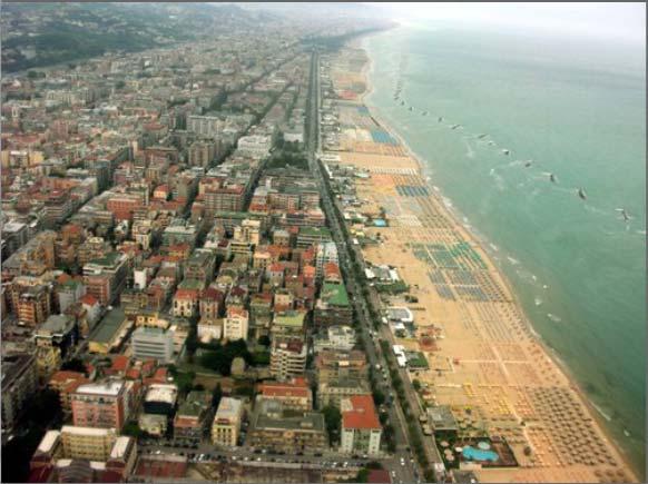


5 Study-area 1 Martinsicuro 2 Cerrano Pescara 4 Ortona Fossacesia 6 San Salvo 6
6 Data used Type Tot Characteristics Year(s) Coverage COSMO Stripmap 13 HH; , ASC- DES, Right 2009, 2010, 2011 Abruzzo COSMO Spotlight 16 HH - VV; , ASC-DES, Right Left 2010, 2011 Pescara Ortona Vasto ERS SAR 1 VV; 19.2, DES 1993 Abruzzo ENVISAT ASAR 1 VV; 18.57, DES 2009 Abruzzo ALOS PALSAR 1 HH; 38.7, ASC 2009 Abruzzo IKONOS 4 5 bands 2004, 2007 Pescara Ortona KOMPSAT bands 2010 Pescara WORLDVIEW bands 2010 Ortona FORMOSAT bands 2010 Pescara

7 In situ data and campaigns
8 Processing and accuracies estimation Geolocation accuracies Methodologies for Coastline extraction Coastline extraction accuracies/validation
9 Optical dataset Geolocation Accuracies 1-3 m, depending on location and dataset Image type RMS E (m) RMS N (m) RMS (m) IKONOS 2004 Ortona 0.82* 0.86* 1.19* IKONOS 2004 Pescara IKONOS 2007 Ortona IKONOS 2007 Pescara KOMPSAT Pescara FORMOSAT Pescara WORLDVIEW Ortona * Residuals estimated on GCP, not on CP: precision and not accuracy estimated in this case
10 Radar dataset: Geolocation Accuracies Tests with 1 Spotlight image NO DEM SRTM DEM (90 m) High Resolution DEM (2 m) Different SW used NEST PCI Geomatica Comparison with ASI GTC product Denomination No ortho ASI GTC SRTM High Res DEM RMS E (m) RMS N (m) RMS (m)
11 Radar dataset: Geolocation Accuracies Dataset Parameter Before coregistration After coregistration RMS E (m) Tests run with the whole dataset: Spotlight: 1-4 m Stripmap : 3-8 m Right: examples of results Spotlight Pescara 06/07/ :01 Spotlight Pescara 07/07/ :01 Spotlight Pescara 07/07/ :54 Spotlight Pescara 09/07/ :07 Spotlight Pescara 10/07/ :13 Spotlight Pescara 10/07/ :00 Spotlight Pescara 14/05/ :46 RMS N (m) RMS (m) RMS E (m) RMS N (m) RMS (m) RMS E (m) RMS N (m) RMS (m) RMS E (m) RMS N (m) RMS (m) RMS E (m) RMS N (m) RMS (m) RMS E (m) RMS N (m) RMS (m) RMS E (m) RMS N (m) RMS (m)


12 Optical dataset: Coastline extraction Semi-automatic techniques based on object-oriented approach. Application on pansharpened data
13 Radar processing: the approach used Multi-looking & De-speckling Edge detection Tracing PCNN Standard approach* Input image Gamma Filter Sobel Mean Treshold Robert s PCNN Tracing Output line *For C-band SAR, based on Lee and Jurkevitch (1990) Coastline detection in SAR images, IEEE Trans, vol 28, 4
14 Pulse Coupled Neural Network (PCNN) Neural Networks algorithms have been shown to be a rather competitive approach for automatic image classification in remote sensing compared to other traditional approaches. PCNN is a relatively novel unsupervised neural network that when applied to image processing, yields a series of binary pulsed signals, each associated to one pixel or to a cluster of pixels. Pulsing Nature of PCNN: the neuron has a Feeding compartment (receiving both an external and a local stimuli), a Linking compartment (only receiving the local stimulus) and an active Threshold value. When the Internal activity becomes larger than the threshold, the neuron fires and the threshold sharply increases. Afterwards, it begins to decay until once again the internal activity becomes larger Epoches F L U Y


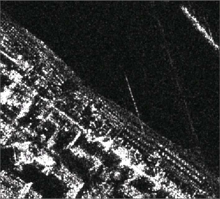
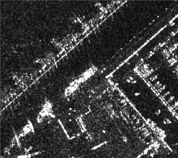
15 Radar Dataset: Coastline extraction
16 PCNN results validation Data available: PCNN Extracted coastline from COSMO-SkyMed acquisition Kinematic GPS simultaneous to COSMO-SkyMed acquisition Validation results: Denomination Average (m) σ(m) First set GPS Second set GPS
 Vs manual (all image) Processing type σ (m) Traditional 17.")
17 PCNN comparison with the classic technique Data available PCNN Extracted coastline Lee Extracted coastline Manually Extracted coastline Kinematic GPS Comparison results: Vs kinematic GPS (1 Km 2 ) Vs manual (all image) Processing type σ (m) Traditional PCNN 3.99


18 Analysis of the sources of inaccuracy in PCNN
19 Conclusions Coastline evolution over Pescara test site Additional applications of COSMO on the area Final remarks


20 Monitoring coastal evolution: Pescara Harbour 1. Spotlight Jul 2010 Spotlight Jul Himage Jul 2010 Himage Jul Rates 2007/11 Rates Jul 2010/11 Trends Erosion Accretion Rates (WLR) m/y (jul) < > +3

.")
21 Potental COSMO-SkyMed applications Monitoring of harbor activities 24 hrs change detection in Pescara harbor. In blue: boats having left the harbor (July 6), in yellow: newly arrived boats (July 7). Spotlight InSAR couple
 dates to")
22 Additional COSMO-SkyMed applications Cartographic updating Regional Cartography (scale 1:5000) dates to 2004/2008
23 Research conclusions PCNN technique validated for X-band coastal retrieval Accuracy shown to be within the range of the pixel size COSMO-Spotlight data seem suitable for coastal studies: Potential for selecting acquisitions corresponding to high/low or 0 tidal height Achievable geolocation accuracy comparable to VHR optical ASI GTC product showed an excellent geolocation accuracy For the test area and the given wind conditions at the time of the acquisitions, HH polarisation resulted preferable to VV (less sensitive to the backscatter of the wavefronts), Incidence angles (better contrast in the scene), Right Descending (or Left Ascending) with an orbit as parallel as possible to the coast Over the study-area and especially in flat areas, long (>2 years) observation timeframes are advisable, due to the entity of phenomenon to monitor and meteomarine bias Multi-temporal monitoring (with COSMO and with multi-sensor VHR) demonstrated
24 Questions?
Ground Deformation Monitoring at Natural Gas Production Sites using Interferometric SAR
 Ground Deformation Monitoring at Natural Gas Production Sites using Interferometric SAR By: Kanika Goel, Robert Shau, Fernando Rodriguez Gonzalez, Nico Adam Remote Sensing Technology Institute (IMF), German
Observations of glacier dynamics with PALSAR DATA
 Observations of glacier dynamics with PALSAR DATA Tazio Strozzi, Urs Wegmüller and Charles Werner Gamma Remote Sensing, Gümligen, Switzerland Rhodes, Greece, 3 to 7 November 2008 Outline ESA GLOBGLACIER
Platform and Products
 International Partnership Space Programme Earth Observation for the Preservation of Ecological Bacalar Corridor Platform and Products Terri Freemantle, Raffaella Guida, Paula Marti, Pasquale Iervolino
Retreating Glaciers of the Himalayas: A Case Study of Gangotri Glacier Using Satellite Images
 Retreating Glaciers of the Himalayas: A Case Study of Gangotri Glacier Using 1990-2009 Satellite Images Jennifer Ding Texas Academy of Mathematics and Science (TAMS) Mentor: Dr. Pinliang Dong Department
EVALUATION OF DIFFERENT METHODS FOR GLACIER MAPPING USING LANDSAT TM
 EVALUATION OF DIFFERENT METHODS FOR GLACIER MAPPING USING LANDSAT TM Frank Paul Department of Geography, University of Zurich, Switzerland Winterthurer Strasse 190, 8057 Zürich E-mail: fpaul@geo.unizh.ch,
Investigation on Development of Agricultural Monitoring System Using Satellite Data
 Investigation on Development of Agricultural Monitoring System Using Satellite Data Genya SAITO (1), Daisuke KUNII (1), Naoki ISHITSUKA (2) (1) Tohoku University, 1-1,Tsutsumidori Amamiya-machi Aoba-ku,
Regional implementation of Electronic Terrain and Obstacle data (e-tod) (Presented by Jeppesen)
 (Presented by Jeppesen)") International Civil Aviation Organization SAM/IG/13-WP/39 South American Regional Office 5/04/14 Thirteenth Workshop/Meeting of the SAM Implementation Group English only (SAM/IG/13) - Regional Project
International Civil Aviation Organization SAM/IG/13-WP/39 South American Regional Office 5/04/14 Thirteenth Workshop/Meeting of the SAM Implementation Group English only (SAM/IG/13) - Regional Project
Using PBN for Terminal and Extended Terminal Operations
 Using PBN for Terminal and Extended Terminal Operations Navigation Performance Data Analysis and its Effect on Route Spacing Dijana Trenevska EUROCONTROL 27 June 2017 Content Background and Objective Data
Potential of CO 2 retrieval from IASI
 Potential of CO 2 retrieval from IASI L. Chaumat, O. Lezeaux, P. Prunet, B. Tournier F.-R. Cayla (SISCLE), C. Camy-Peyret (LPMAA) and T. Phulpin (CNES) Study supported by CNES ITSC-XVI: Angra dos Reis,
SCRAMJET. Mapping and monitoring airports with Sentinel 1 and 2 data
 SCRAMJET Mapping and monitoring airports with Sentinel 1 and 2 data 18/03/2018 GISTAM 2018 Urban geospatial mapping for the SCRAMJET business networking tool Nuno Duro, Pedro Coutinho, Gil Gonçalves Index
The Past, Present, and Future of Nortek and Glider Measurements
 The Past, Present, and Future of Nortek and Glider Measurements Peter J. Rusello Scientist Nortek Since 2005, Nortek has collaborated with leading researchers to develop specialized acoustic Doppler current
IAC 2011 Cape Town, October th
 Cape Town, October 05 05 th Project Partners External Supporters and Sponsors The Problem The Solution Overview S 2 BAS Concept of Operations Architecture Possible Applications Stakeholders Flight Phases
EO-based services to support humanitarian operations: monitoring population and natural resources in refugee/idp camps
 How satellites can help to save lives Vienna, Austria 23 February 2016 EO-based services to support humanitarian operations: monitoring population and natural resources in refugee/idp camps Petra FÜREDER
A method for automated snow avalanche debris detection through use of synthetic aperture radar (SAR) imaging
 imaging") PUBLICATIONS Earth and Space Science RESEARCH ARTICLE Key Points: Radar remote sensing of snow avalanche debris Automatic detection algorithm Operational monitoring of avalanches A method for automated
PUBLICATIONS Earth and Space Science RESEARCH ARTICLE Key Points: Radar remote sensing of snow avalanche debris Automatic detection algorithm Operational monitoring of avalanches A method for automated
Japan Earthquake and Tsunami: a view from satellite data
 Università degli studi di Roma Tor Vergata Corso di Telerilevamento e Cartografia Anno accademico 2012/2013 Japan Earthquake and Tsunami: a view from satellite data Dr. Matteo Picchiani picchiani@disp.uniroma2.it
Integrated Applications Programme (IAP) & Space for UAS UAS for Applications
 & Space for UAS UAS for Applications") ESA s Integrated Applications Programme (IAP) & Space for UAS UAS for Applications M. Vaissiere ESA Director of Telecommunications and Integrated Applications Programme European High Level UAS Conference
ESA s Integrated Applications Programme (IAP) & Space for UAS UAS for Applications M. Vaissiere ESA Director of Telecommunications and Integrated Applications Programme European High Level UAS Conference
Coverage of Mangrove Ecosystem along Three Coastal Zones of Puerto Rico using IKONOS Sensor
 Coverage of Mangrove Ecosystem along Three Coastal Zones of Puerto Rico using IKONOS Sensor Jennifer Toledo Rivera Geology Department, University of Puerto Rico, Mayagüez Campus P.O. Box 9017 Mayagüez,
Using of space technologies for glacierand snow- related hazards studies
 United Nations / Germany international conference on International Cooperation Towards Low-Emission and Resilient Societies Using of space technologies for glacierand snow- related hazards studies Bonn,
A SEGMENTED ARCHITECTURE APPROACH TO PROVIDE A CONTINUOUS, LONG-TERM, ADAPTIVE AND COST- EFFECTIVE GLACIERS MONITORING SYSTEM
 1st IAA Latin American Symposium on Small Satellites: Advanced Technologies and Distributed Systems A SEGMENTED ARCHITECTURE APPROACH TO PROVIDE A CONTINUOUS, LONG-TERM, ADAPTIVE AND COST- EFFECTIVE GLACIERS
Figure Pre- and post-disaster satellite topographical maps
 2.1.3 Image analysis by JAXA JAXA conducted ongoing emergency observations using Daichi in the wake of the Great East Japan Earthquake, releasing reporting of its analysis of eastern Japan and Hokkaido
Glacial lakes as sentinels of climate change in Central Himalaya, Nepal
 Glacial lakes as sentinels of climate change in Central Himalaya, Nepal Sudeep Thakuri 1,2,3, Franco Salerno 1,3, Claudio Smiraglia 2,3, Carlo D Agata 2,3, Gaetano Viviano 1,3, Emanuela C. Manfredi 1,3,
The 2nd Glacier Inventory of China
 The 2nd Glacier Inventory of China LIU Shiyin Guo Wanqin, Xu Junli, Shangguan Donghui, Wei Junfeng, Wu Lizong, Yu Pengchun, Li Jing, Liu Qiao State Key Laboratory of Cryospheric Sciences, Cold and Arid
UAS to GIS Utilizing a low-cost Unmanned Aerial System (UAS) for Coastal Erosion Monitoring
 for Coastal Erosion Monitoring") UAS to GIS Utilizing a low-cost Unmanned Aerial System (UAS) for Coastal Erosion Monitoring Agenda Scope of today s presentation Demonstration Objectives Wrightsville Beach Test Area Masonboro Inlet Jetties
UAS to GIS Utilizing a low-cost Unmanned Aerial System (UAS) for Coastal Erosion Monitoring Agenda Scope of today s presentation Demonstration Objectives Wrightsville Beach Test Area Masonboro Inlet Jetties
A GEOGRAPHIC ANALYSIS OF OPTIMAL SIGNAGE LOCATION SELECTION IN SCENIC AREA
 A GEOGRAPHIC ANALYSIS OF OPTIMAL SIGNAGE LOCATION SELECTION IN SCENIC AREA Ling Ruan a,b,c, Ying Long a,b,c, Ling Zhang a,b,c, Xiao Ling Wu a,b,c a School of Geography Science, Nanjing Normal University,
EO technologies for flood mapping and hydrological modelling in Namibia
 Satellite Earth Observation & Disaster Risks EO technologies for flood mapping and hydrological modelling in Namibia Guido Van Langenhove, Hydrological Services Namibia Hydrological trends in Namibia:
Monitoring of Mountain Glacial Variations in Northern Pakistan, from 1992 to 2008 using Landsat and ALOS Data. R. Jilani, M.Haq, A.
 Monitoring of Mountain Glacial Variations in Northern Pakistan, from 1992 to 2008 using Landsat and ALOS Data R. Jilani, M.Haq, A. Naseer Pakistan Space & Upper Atmosphere Research Commission (SUPARCO)
Learning Objectives. By the end of this presentation you should understand:
 Designing Routes 1 Learning Objectives By the end of this presentation you should understand: Benefits of RNAV Considerations when designing airspace routes The basic principles behind route spacing The
Cal/Val Activities at the CIGSN Uardry Field Site, NSW, Australia in Support of the EO-1 Mission
 Cal/Val Activities at the CIGSN Uardry Field Site, NSW, Australia in Support of the EO-1 Mission Fred Prata and Graham Rutter CSIRO Atmospheric Research David Jupp CSIRO Earth Observation Centre EOC Annual
ASPASIA Project. ASPASIA Overall Summary. ASPASIA Project
 ASPASIA Project ASPASIA Overall Summary ASPASIA Project ASPASIA Project ASPASIA (Aeronautical Surveillance and Planning by Advanced ) is an international project co-funded by the European Commission within
Approach Specifications
 Approach Specifications RNP Approach (RNP APCH) and Baro-VNAV Approach Specifications RNP APCH and Baro-VNAV 1 Overview Learning Objectives: At the end of this presentation, you should: Understand the
Anomaly Detection in airlines schedules. Asmaa Fillatre Data Scientist, Amadeus
 Anomaly Detection in airlines schedules Asmaa Fillatre Data Scientist, Amadeus AMADEUS PRESENTATION 1. IT company that develops business solutions for the travel and tourism industry 2. Operates globally
RNP OPERATIONS. We will now explain the key concepts that should not be mixed up and that are commonly not precisely understood.
 RNP OPERATIONS 1. Introduction Planes were made as a means of transport. To successfully fly from a location A to a location B, pilots were first and foremost navigators. Originally relying on visual landmarks
DETECTION OF ICE FRONT INITIATION ON THE PEACE RIVER IN NORTHERN ALBERTA Freeze-up
 FINAL REPORT DETECTION OF ICE FRONT INITIATION ON THE PEACE RIVER IN NORTHERN ALBERTA Freeze-up 2013-2014 REFERENCE NO. CO 73797 Presented to: British Columbia Hydro and Power Authority Prepared by: Monique
GEOSPATIAL ANALYSIS OF GLACIAL HAZARDS PRONE AREAS OF SHIGAR AND SHAYOK BASINS OF PAKISTAN. By Syed Naseem Abbas Gilany
 GEOSPATIAL ANALYSIS OF GLACIAL HAZARDS PRONE AREAS OF SHIGAR AND SHAYOK BASINS OF PAKISTAN By Syed Naseem Abbas Gilany PRESENTATION OUTLINE Introduction Problem Statement / Rationale Objectives Material
A GIS Analysis of Probable High Recreation Use Areas in Three Sisters Wilderness Deschutes and Willamette National Forests
 Lindsey Kiesz Geo 565 Term Project 3/15/2010 A GIS Analysis of Probable High Recreation Use Areas in Three Sisters Wilderness Deschutes and Willamette National Forests Introduction The Three Sisters Wilderness
Implementation of PBN in Armenian airspace
 Implementation of PBN in Armenian airspace PBN implementation plan, based on the specifications of the airspace of the Republic of Armenia, has been developed in accordance with Resolution A36-23, approved
CITY OF LYNDEN STORMWATER MANAGEMENT PROGRAM REPORT MARCH 1, 2016
 CITY OF LYNDEN STORMWATER MANAGEMENT PROGRAM 2015 WATER QUALITY MONITORING REPORT CITY OF LYNDEN 300 4 TH STREET LYNDEN, WASHINGTON 98264 PHONE (360) 354-3446 MARCH 1, 2016 This document serves as an attachment
Cost-Effective Flight Test Training Using In-House Resources: An application to the HAF Academy
 Cranfield University Alumni Event and Defense Education Conference Athens, 1 June 2017 Cost-Effective Flight Test Training Using In-House Resources: Cpt (HAF) Aristidis Antonakis HAF Electronics Depot
Net of Innovation. July 2015 Dave Finger, Mark Foster
 Net of Innovation July 2015 Dave Finger, Mark Foster Table of Contents The Challenges and Solutions to Safe Outdoor Testing... 2 Types of Testing a Netted Enclosure Enables... 4 Flight Plan Testing...
USING ECOGNITION TO AUTOMATICALLY DETECT AND MAP AVALANCHE DEPOSITS FROM THE SPRING 2009 AVALANCHE CYCLE IN THE TATRA MTS.
 USING ECOGNITION TO AUTOMATICALLY DETECT AND MAP AVALANCHE DEPOSITS FROM THE SPRING 2009 AVALANCHE CYCLE IN THE TATRA MTS., SLOVAKIA R. Frauenfelder a, 0F*, M. J. Lato b, M. Biskupič c,d a Norwegian Geotechnical
30th IBSC Conference - Stavanger, Norway June, Takahiro TOKUI
 Bird Strike Control and Reduction in JAPAN 30th IBSC Conference - Stavanger, Norway 25-29 June, 2012 Takahiro TOKUI Civil Aviation Bureau (CAB), Ministry of Land Infrastructure, Transport and Tourism (MLIT),
Challenges in Complex Procedure Design Validation
 Challenges in Complex Procedure Design Validation Frank Musmann, Aerodata AG ICAO Workshop Seminar Aug. 2016 Aerodata AG 1 Procedure Validation Any new or modified Instrument Flight Procedure is required
RNP 2 JOB AID REQUEST TO CONDUCT RNP 2 OPERATIONS
 RNP 2 Job Aid SRVSOP RNP 2 JOB AID REQUEST TO CONDUCT RNP 2 OPERATIONS 1. Introduction This Job Aid was developed by the Latin American Regional Safety Oversight Cooperation System (SRVSOP) to provide
A high resolution glacier model with debris effects in Bhutan Himalaya. Orie SASAKI Kanae Laboratory 2018/02/08 (Thu)
") A high resolution glacier model with debris effects in Bhutan Himalaya Orie SASAKI Kanae Laboratory 2018/02/08 (Thu) Research flow Multiple climate data at high elevations Precipitation, air temperature
A high resolution glacier model with debris effects in Bhutan Himalaya Orie SASAKI Kanae Laboratory 2018/02/08 (Thu) Research flow Multiple climate data at high elevations Precipitation, air temperature
(HELICOPTER FORCE LANDED AND BURNT OUT AFTER ENGINE FIRE WARNINGS)
") Follow-up Action on Occurrence Report ACCIDENT TO SIKORSKY S61N, G-BBHM, AT POOLE, DORSET ON 15 JULY 2002 (HELICOPTER FORCE LANDED AND BURNT OUT AFTER ENGINE FIRE WARNINGS) CAA FACTOR NUMBER : F21/2004
Follow-up Action on Occurrence Report ACCIDENT TO SIKORSKY S61N, G-BBHM, AT POOLE, DORSET ON 15 JULY 2002 (HELICOPTER FORCE LANDED AND BURNT OUT AFTER ENGINE FIRE WARNINGS) CAA FACTOR NUMBER : F21/2004
USE OF 3D GIS IN ANALYSIS OF AIRSPACE OBSTRUCTIONS
 USE OF 3D GIS IN ANALYSIS OF AIRSPACE OBSTRUCTIONS A project by by Samuka D. W. F19/1461/2010 Supervisor; Dr D. N. Siriba 1 Background and Problem Statement The Airports in Kenya are the main link between
Quality Assurance. Introduction Need for quality assurance Answer to the need of quality assurance Details on quality assurance Conclusion A B C D E
 Quality Assurance 1 A B C D E Introduction Need for quality assurance Answer to the need of quality assurance Details on quality assurance Conclusion 2 1 Introduction 3 Introduction The implementation
AUTHORITATIVE AIRPORT DATA FOR CRITICAL FLIGHT SAFETY AND AUTOMATED SITUATIONAL AWARENESS MEETS FAA (USA) AND ICAO (INT'L) REQUIREMENTS
 AND ICAO (INT'L) REQUIREMENTS") AUTHORITATIVE AIRPORT DATA FOR CRITICAL FLIGHT SAFETY AND AUTOMATED SITUATIONAL AWARENESS MEETS FAA (USA) AND ICAO (INT'L) REQUIREMENTS H. Howard a, P. Hummel b a CompassData, Inc, Centennial, Colorado,
AUTHORITATIVE AIRPORT DATA FOR CRITICAL FLIGHT SAFETY AND AUTOMATED SITUATIONAL AWARENESS MEETS FAA (USA) AND ICAO (INT'L) REQUIREMENTS H. Howard a, P. Hummel b a CompassData, Inc, Centennial, Colorado,
A Statistical Method for Eliminating False Counts Due to Debris, Using Automated Visual Inspection for Probe Marks
 A Statistical Method for Eliminating False Counts Due to Debris, Using Automated Visual Inspection for Probe Marks SWTW 2003 Max Guest & Mike Clay August Technology, Plano, TX Probe Debris & Challenges
The Computerized Analysis of ATC Tracking Data for an Operational Evaluation of CDTI/ADS-B Technology
 DOT/FAA/AM-00/30 Office of Aviation Medicine Washington, D.C. 20591 The Computerized Analysis of ATC Tracking Data for an Operational Evaluation of CDTI/ADS-B Technology Scott H. Mills Civil Aeromedical
OVERVIEW OF THE FAA ADS-B LINK DECISION
 June 7, 2002 OVERVIEW OF THE FAA ADS-B LINK DECISION Summary This paper presents an overview of the FAA decision on the ADS-B link architecture for use in the National Airspace System and discusses the
Enabling Civilian Low-Altitude Airspace and Unmanned Aerial System (UAS) Operations. Unmanned Aerial System Traffic Management (UTM)
 Operations. Unmanned Aerial System Traffic Management (UTM)") Enabling Civilian Low-Altitude Airspace and Unmanned Aerial System (UAS) Operations By Unmanned Aerial System Traffic Management (UTM) Parimal Kopardekar, Ph.D. UTM Principal Investigator and Manager,
Enabling Civilian Low-Altitude Airspace and Unmanned Aerial System (UAS) Operations By Unmanned Aerial System Traffic Management (UTM) Parimal Kopardekar, Ph.D. UTM Principal Investigator and Manager,
NASA s Role in Integration of UAVs
 National Aeronautics and Space Administration NASA s Role in Integration of UAVs Half a Century of Innovation David McBride, Director Dryden Flight Research Center www.nasa.gov www.nasa.gov 2 The 1960s
Operators may need to retrofit their airplanes to ensure existing fleets are properly equipped for RNP operations. aero quarterly qtr_04 11
 Operators may need to retrofit their airplanes to ensure existing fleets are properly equipped for RNP operations. 24 equipping a Fleet for required Navigation Performance required navigation performance
Potomac River Commuter Ferry Feasibility Study & RPE Results
 1.1 Introduction The Prince William County Department of Transportation conducted a route proving exercise (RPE) and feasibility study of a proposed commuter ferry service on the Potomac River between
Identifying and Utilizing Precursors
 Flight Safety Foundation European Aviation Safety Seminar Lisbon March 15-17 / 2010 Presented by Michel TREMAUD ( retired, Airbus / Aerotour / Air Martinique, Bureau Veritas ) Identifying and Utilizing
Título ponencia: Introduction to the PBN concept
 Título ponencia: Introduction to the PBN concept Organizado por: Index Introduction Background PBN Concept PBN Operations Conclusions Introduction Subject This presentation addresses the Performance-Based
Hosted Flight Data Monitoring. Information Sheet
 17 Wellington Business Park Crowthorne Berkshire RG45 6LS England Tel: +44 (0) 1344 234047 www.flightdatapeople.com Hosted Flight Data Monitoring Information Sheet www.flightdatapeople.com Commercial in
Air Navigation Bureau ICAO Headquarters, Montreal
 Performance Based Navigation Introduction to PBN Air Navigation Bureau ICAO Headquarters, Montreal 1 Performance Based Navigation Aviation Challenges Navigation in Context Transition to PBN Implementation
Key Purpose & Need Issues
 Key Purpose & Need Issues Efficiently meet demand through the 2025 planning horizon 864,000+ annual operations 180-200 operations during peak daytime hours Balance peak hour arrival/departure capability
NASA s Automatic Dependent Surveillance Broadcast: ADS-B Sense-and-Avoid System
 NASA s Automatic Dependent Surveillance Broadcast: ADS-B Sense-and-Avoid System October 30, 2014 Ricardo Arteaga NASA Armstrong Flight Research Center is a world class leader in cutting-edge Systems Engineer
Air Traffic Complexity: An Input-Output Approach. Amy R Pritchett, Keumjin Lee and Eric JM Feron School of Aerospace Engineering Georgia Tech
 Air Traffic Complexity: An Input-Output Approach Amy R Pritchett, Keumjin Lee and Eric JM Feron School of Aerospace Engineering Georgia Tech Motivation Efforts to balance air traffic demand and airspace
Saint Petersburg-Clearwater International Airport. Airspace & Instrument Approach Analysis
 Saint Petersburg-Clearwater International Airport Airspace & Instrument Approach Analysis February 23, 2005 Jeppesen Boeing Jeppesen Government / Military Services Group Airspace Services Division AIRSPACE
Unmanned Aircraft System (UAS): regulatory framework and challenges. NAM/CAR/SAM Civil - Military Cooperation Havana, Cuba, April 2015
: regulatory framework and challenges. NAM/CAR/SAM Civil - Military Cooperation Havana, Cuba, April 2015") Unmanned Aircraft System (UAS): regulatory framework and challenges NAM/CAR/SAM Civil - Military Cooperation Havana, Cuba, 13 17 April 2015 Overview Background Objective UAV? Assumptions Challenges Regulatory
Unmanned Aircraft System (UAS): regulatory framework and challenges NAM/CAR/SAM Civil - Military Cooperation Havana, Cuba, 13 17 April 2015 Overview Background Objective UAV? Assumptions Challenges Regulatory
MASTER S THESIS. Ioannis Mamalikidis, UID: 633
 MASTER S THESIS Aristotle University of Thessaloniki, Faculty of Sciences, Department of Informatics Supervisor: Dr. Eleftherios Angelis; Thesis Committee: Grigorios Tsoumakas, Ioannis Vlahavas Ioannis
Preliminary Results from the ATHENA-OAWL Venture Tech Airborne Mission
 Preliminary Results from the ATHENA-OAWL Venture Tech Airborne Mission Sunil Baidar (a, b), Sara Tucker (c), Mike Hardesty (a, b) (a) CIRES, University of Colorado Boulder, Boulder, CO (b) NOAA Earth System
PBN ROUTE SPACING AND CNS REQUIREMENTS (Presented by Secretariat)
") International Civil Aviation Organization The First Meeting of South China Sea Major Traffic Flow Review Group (SCS-MTFRG/1) Kuala Lumpur, Malaysia, 19-20 January 2015 Agenda Item 5: Discuss strategy for
International Civil Aviation Organization The First Meeting of South China Sea Major Traffic Flow Review Group (SCS-MTFRG/1) Kuala Lumpur, Malaysia, 19-20 January 2015 Agenda Item 5: Discuss strategy for
Space Based ADS-B. ICAO SAT meeting - June 2016 AIREON LLC PROPRIETARY INFORMATION
 Space Based ADS-B ICAO SAT meeting - June 2016 1 Options to Detect an Aircraft Position Position Accuracy / Update Interval Voice Position Reporting ADS-C Position Reporting Radar Surveillance / MLAT Space
Survey of Littleton Down
 Survey of Littleton Down 05 November 2014 The Team: John and Jenny Barnard 1) Introduction Littleton Down (Hill Number 2911, Section 42, OS 1:50000 Map 197, OS 1:25000 Map 121, Grid Ref. SU941150) is listed
Flight inspection and validation
 We build on long traditions of Norwegian leading edge aviation experience. We employ a dedicated and highly skilled team of engineers. Strategic partnerships positions Norwegian Special Mission AS as one
ADS-B Rule and Installation Guidance
 ADS-B Rule and Installation Guidance Presented by: Don Walker Date: June 2011 Outline U.S. ADS-B Rulemaking Airspace Rule Rule performance requirements AC 20-165 Installation and airworthiness approval
AUTOMATIC GLACIER SURFACE ANALYSIS FROM AIRBORNE LASER SCANNING
 IAPRS Volume XXXVI, Part 3 / W52, 2007 AUTOMATIC GLACIER SURFACE ANALYSIS FROM AIRBORNE LASER SCANNING M.P. Kodde a, N. Pfeifer b, B.G.H. Gorte c, T. Geist d, B. Höfle e a. Fugro-Inpark, Dillenburgsingel
HEAD-UP DISPLAY (HUD), EQUIVALENT DISPLAYS AND VISION SYSTEMS
, EQUIVALENT DISPLAYS AND VISION SYSTEMS") ATT 2.B-1 ATTACHMENT 2.B HEAD-UP DISPLAY (HUD), EQUIVALENT DISPLAYS AND VISION SYSTEMS Supplementary to 2.2.2.2, 2.4.15.1, 3.4.2.7 and 3.6.12 Introduction The material in this attachment provides guidance
ATT 2.B-1 ATTACHMENT 2.B HEAD-UP DISPLAY (HUD), EQUIVALENT DISPLAYS AND VISION SYSTEMS Supplementary to 2.2.2.2, 2.4.15.1, 3.4.2.7 and 3.6.12 Introduction The material in this attachment provides guidance
UPDATING THE SURFACE AREA AND VOLUME EQUATIONS OF LAKE NASSER USING MULTIBEAM SYSTEM
 UPDATING THE SURFACE AREA AND VOLUME EQUATIONS OF LAKE NASSER USING MULTIBEAM SYSTEM Nader M. Shafik Researcher, Nile Research Institute, E-mail: shafik_nader@yahoo.com ABSTRACT Lake Nasser is the main
Product Description. SmartRunway and SmartLanding. functions of the. Enhanced Ground Proximity Warning System
 Product Description SmartRunway and SmartLanding functions of the Enhanced Ground Proximity Warning System Table of Contents 1. PURPOSE AND APPLICABILITY -------------------------------------------------------------------------------
The support of an European ANSP
 The support of an European ANSP Euromed GNSS II project/medusa Final event on GNSS for aviation Patrizio Vanni (GNSS expert) International Strategies Office patrizio.vanni@enav.it MEDUSA final event on
Demand Forecast Uncertainty
 Demand Forecast Uncertainty Dr. Antonio Trani (Virginia Tech) CEE 4674 Airport Planning and Design April 20, 2015 Introduction to Airport Demand Uncertainty Airport demand cannot be predicted with accuracy
To optimize Wake Vortex separations. Fabrice ORLANDI THALES AIR SYSTEMS
 To optimize Wake Vortex separations Fabrice ORLANDI THALES AIR SYSTEMS To optimize Wake Vortex separations 21/10/2015 http://www.ufo-wind-sensors.eu/ London 3 / 22 UFO OPERATIONAL GOALS UFO is studying
PREFACE. Service frequency; Hours of service; Service coverage; Passenger loading; Reliability, and Transit vs. auto travel time.
 PREFACE The Florida Department of Transportation (FDOT) has embarked upon a statewide evaluation of transit system performance. The outcome of this evaluation is a benchmark of transit performance that
New measurements techniques
 2 nd Asia CryoNetWorkshop New measurements techniques Xiao Cunde (SKLCS/CAS and CAMS/CMA) Feb.5, 2016, Salekhard, Russia Outline Definition of New Some relative newly-used techniques in China -- Eddy covariance
RACOON PROJECT Daniele Teotino - ENAV. RACOON Project Manager Head of SESAR JU Activity Coordination
 RACOON PROJECT Daniele Teotino - ENAV RACOON Project Manager Head of SESAR JU Activity Coordination RACOON in a Nutshell SESAR JU Very Large Scale Demonstration First Italian initiative on Remote TWR solutions
Contextual note SESAR Solution description form for deployment planning
 Purpose: Release 5 SESAR Solution ID #12 Contextual note SESAR Solution description form for deployment planning This contextual note introduces a SESAR Solution (for which maturity has been assessed as
RNP AR and Air Traffic Management
 RNP AR and Air Traffic Management BOEING is a trademark of Boeing Management Company. Copyright 2009 Boeing. All rights reserved. Expanding the Utility of RNP AR Sheila Conway RNP AR User s Forum Wellington,
Overview of Evolution to Performance Based Navigation. ICAO PBN Seminar Overview of Evolution to Performance Based Navigation
 Overview of Evolution to Performance Based Navigation 1 Overview Learning Objectives: at the end of this presentation you should: Understand what are the two main elements of Performance Based Navigation
CIVIL AVIATION REGULATIONS SURINAME PART 17 - AERONAUTICAL TELECOMMUNICATIONS VERSION 5.0
 CIVIL AVIATION REGULATIONS SURINAME PART 17 - AERONAUTICAL TELECOMMUNICATIONS VERSION 5.0 January 2018 AMENDMENTS Location Date Amended by Description CONTENTS 17.1 GENERAL... 4 17.1.1 Applicability...
PBN and RNAV concepts
 PBN and RNAV concepts Rabat, 16/27-03-2015 Target: Learn basic concept on PBN and RNAV. NOT FOR COMMERCIAL PURPOSES 2 Concepts Part 1: PBN concept Part 2: RNAV, RNP Part 3: FTE (Flight Technical Error)
Water Quality Monitoring and Validation from NOAA operational satellite sensor (VIIRS) Data Products in Coral Reef Environments
 Data Products in Coral Reef Environments") Water Quality Monitoring and Validation from NOAA operational satellite sensor (VIIRS) Data Products in Coral Reef Environments William J Hernandez, Ph.D 1, 4 Post-Doctoral Researcher Roy A. Armstrong
Water Quality Monitoring and Validation from NOAA operational satellite sensor (VIIRS) Data Products in Coral Reef Environments William J Hernandez, Ph.D 1, 4 Post-Doctoral Researcher Roy A. Armstrong
ATM Seminar 2015 OPTIMIZING INTEGRATED ARRIVAL, DEPARTURE AND SURFACE OPERATIONS UNDER UNCERTAINTY. Wednesday, June 24 nd 2015
 OPTIMIZING INTEGRATED ARRIVAL, DEPARTURE AND SURFACE OPERATIONS UNDER UNCERTAINTY Christabelle Bosson PhD Candidate Purdue AAE Min Xue University Affiliated Research Center Shannon Zelinski NASA Ames Research
New issues raised on collision avoidance by the introduction of remotely piloted aircraft (RPA) in the ATM system
 in the ATM system") New issues raised on collision avoidance by the introduction of remotely piloted aircraft (RPA) in the ATM system Jean-Marc Loscos DSNA expert on collision avoidance and airborne surveillance EIWAC 2013
New issues raised on collision avoidance by the introduction of remotely piloted aircraft (RPA) in the ATM system Jean-Marc Loscos DSNA expert on collision avoidance and airborne surveillance EIWAC 2013
Revenue Management in a Volatile Marketplace. Tom Bacon Revenue Optimization. Lessons from the field. (with a thank you to Himanshu Jain, ICFI)
") Revenue Management in a Volatile Marketplace Lessons from the field Tom Bacon Revenue Optimization (with a thank you to Himanshu Jain, ICFI) Eyefortravel TDS Conference Singapore, May 2013 0 Outline Objectives
Revenue Management in a Volatile Marketplace Lessons from the field Tom Bacon Revenue Optimization (with a thank you to Himanshu Jain, ICFI) Eyefortravel TDS Conference Singapore, May 2013 0 Outline Objectives
Cross-sectional time-series analysis of airspace capacity in Europe
 Cross-sectional time-series analysis of airspace capacity in Europe Dr. A. Majumdar Dr. W.Y. Ochieng Gerard McAuley (EUROCONTROL) Jean Michel Lenzi (EUROCONTROL) Catalin Lepadatu (EUROCONTROL) 1 Introduction
Robson Valley Avalanche Tract Mapping Project
 Robson Valley Avalanche Tract Mapping Project Prepared for: Chris Ritchie Ministry of Water Land and Air Protection 325 1011 4th Avenue Prince George, BC. V2L3H9 and Dale Seip Ministry of Forests 1011
OPERATIONS CIRCULAR 01/2012. Subject: HEAD-UP DISPLAYS (HUD) AND ENHANCED VISION SYSTEMS (EVS)
 AND ENHANCED VISION SYSTEMS (EVS)") GOVERNMENT OF INDIA CIVIL AVIATION DEPARTMENT OFFICE OF THE DIRECTOR GENERAL OF CIVIL AVIATION OPP. SAFDARJUNG AIRPORT, NEW DELHI 110 003 TELEPHONE: 091-011-4635261 4644768 FAX: 091-011-4644764 TELEX:
GOVERNMENT OF INDIA CIVIL AVIATION DEPARTMENT OFFICE OF THE DIRECTOR GENERAL OF CIVIL AVIATION OPP. SAFDARJUNG AIRPORT, NEW DELHI 110 003 TELEPHONE: 091-011-4635261 4644768 FAX: 091-011-4644764 TELEX:
Got Mountains? Challenges of Modeling SRTM and Other Terrain Data to Suit Aviation Applications
 Got Mountains? Challenges of Modeling SRTM and Other Terrain Data to Suit Aviation Applications M. Fox, B. Dorrell, L. Haskell, Jeppesen, 55 Inverness Drive East, Englewood, CO 80112 Abstract Jeppesen,
Buchanan Field. Airport Planning Program. FAR Part 150 Meeting. September 28, Master Plan FAR Part 150 Noise Study Strategic Business Plan
 Airport Planning Program Master Plan FAR Part 150 ise Study Strategic Business Plan FAR Part 150 Meeting September 28, 2006 Agenda Introduction Part 150 Study Working Paper Two Operational Alternatives
USING REMOTE SENSING AND RPAS FOR ARCHAEOLOGY AND MONITORING IN WESTERN GREENLAND
 USING REMOTE SENSING AND RPAS FOR ARCHAEOLOGY AND MONITORING IN WESTERN GREENLAND K. Pavelka*, J. Šedina, E. Matoušková, M. Faltýnová, I.Hlaváčová Department of Mapping and Cartography, Faculty of Civil
ICAO Big Data Project ADS-B Data as a source for analytical solutions for traffic behaviour in airspace
 ICAO Big Data Project ADS-B Data as a source for analytical solutions for traffic behaviour in airspace ICAO/IATA/CANSO PBN/2 San Jose December 8, 2016 Big Data process Quantitative Quantitative / Qualitative
TWELFTH AIR NAVIGATION CONFERENCE
 International Civil Aviation Organization 17/5/12 WORKING PAPER TWELFTH AIR NAVIGATION CONFERENCE Montréal, 19 to 30 November 2012 Agenda Item 4: Optimum Capacity and Efficiency through global collaborative
Airspace Encounter Models for Conventional and Unconventional Aircraft
 Airspace Encounter Models for Conventional and Unconventional Aircraft Matthew W. Edwards, Mykel J. Kochenderfer, Leo P. Espindle, James K. Kuchar, and J. Daniel Griffith Eighth USA/Europe Air Traffic
MULTIDISCIPLINARYMEETING REGARDING GLOBAL TRACKING
 International Civil Aviation Organization Global Tracking 2014-WP/1 5/5/14 WORKING PAPER MULTIDISCIPLINARYMEETING REGARDING GLOBAL TRACKING Montréal, 12 May to 13 May 2014 Agenda item 1: Explore the need