Water Quality Monitoring and Validation from NOAA operational satellite sensor (VIIRS) Data Products in Coral Reef Environments
|
|
|
- Earl Gibson
- 5 years ago
- Views:
Transcription

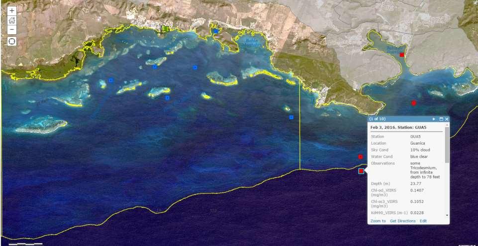
1 Water Quality Monitoring and Validation from NOAA operational satellite sensor (VIIRS) Data Products in Coral Reef Environments William J Hernandez, Ph.D 1, 4 Post-Doctoral Researcher Roy A. Armstrong 1,3, Alan E. Strong, Robert A. Warner 5, Erick F. Geiger 2,4, C. Mark Eakin 4, Menghua Wang 4, Maria A. Cardona-Maldonado 3, Suhey Ortiz-Rosa 1, Jeremy Kravitz 6, Myrna J. Santiago 3 Decimocuarta Reunión de Percepción Remota y Sistemas de Información Geográfica de Puerto Rico, UPR Mayagüez, Octubre 7, NOAA-CREST UPRM, 2 Global Science and Technology Inc., 3 NOAA-NCAS UPR Mayaguez, 4 NOAA/NESDIS/STAR, 5 NOAA/NOS/NCCOS, 6 UPR Mayaguez.
2 Introduction Water Quality Coral reef Visible Infrared Imaging Radiometer Suite (VIIRS) Sensor products Virtual Areas Results VIIRS products Water quality Conclusions


3 Land based sources of pollution (LBSP) are a major threat to corals: Cause disease and mortality Disrupt critical ecological reef functions that impede growth and reproduction and larval settlement. Innovations in Monitoring and Assessment. Connecting Coasts, Estuaries, and Freshwater Ecosystems. Identifying and Assessing Emerging Risks. Measuring Effectiveness of Water Management Actions. Honokahua Bay, West Maui. Credit: Bill Rathfon. Guanica Bay, Puerto Rico Credit: NOAA

4 Visible Infrared Imaging Radiometer Suite NOAA/NESDIS/STAR Spectral coverage: 412nm -12 μm 22 bands, 750m, 375m spatial res. Daily images Products: Cloud cover, aerosols Land & ocean biosphere Sea Surface Temperature Fire detection Imagery
 Diffuse attenuation coefficient at 490nm.")

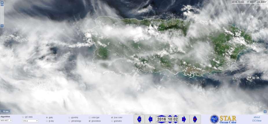
5 Chlorophyll-a (Chl-a) Monitoring phytoplankton biomass. Nutrient status (i.e. productivity). Index of water quality. Kd(490) Diffuse attenuation coefficient at 490nm. Turbidity (measure of the total organic and inorganic matter held in solution and suspension). Index of water quality. VIIRS Kd(490) product image for Puerto Rico and the USVI after a precipitation event (August 26, 2014).


6 The color of coastal water is related to water quality. Satellite ocean color data provide a synoptic view of water quality. Continuous monitoring Ocean color tools that managers and stakeholders can use to: Track water quality near their reefs Evaluate effect in the coastal water due to changes in the watershed. ( Ridge to Reef ). Image credit: Bio-optical oceanography Lab, UPRM
 Guánica Bay (Puerto Rico).")
7 U.S. Coral Reef Task Force priority watershed sites: Ka anapali (West Maui, Hawai'i) Faga'alu (American Samoa) Guánica Bay (Puerto Rico). Image credit: NOAA/NESDIS/STAR/CRW

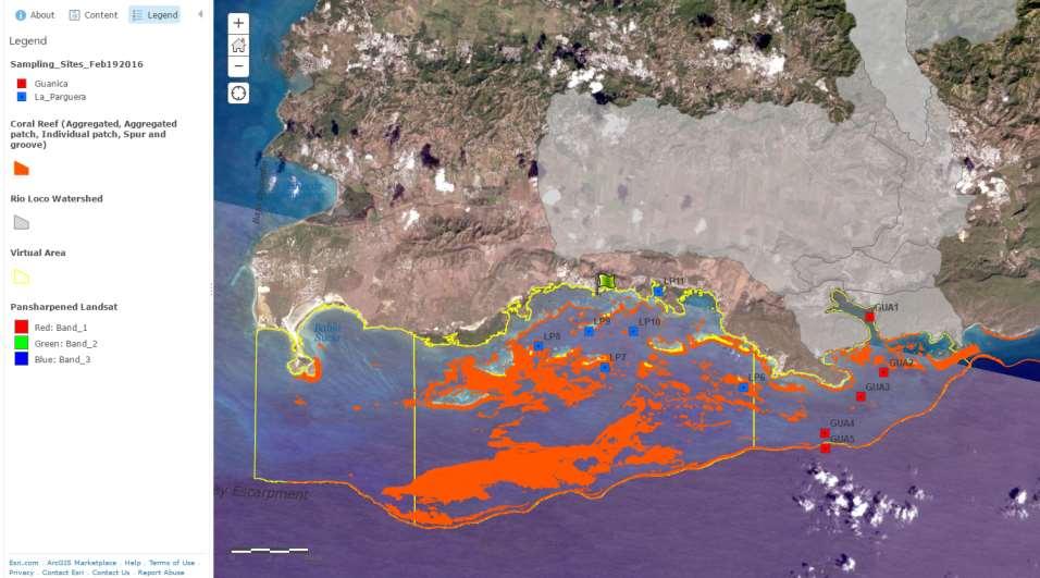
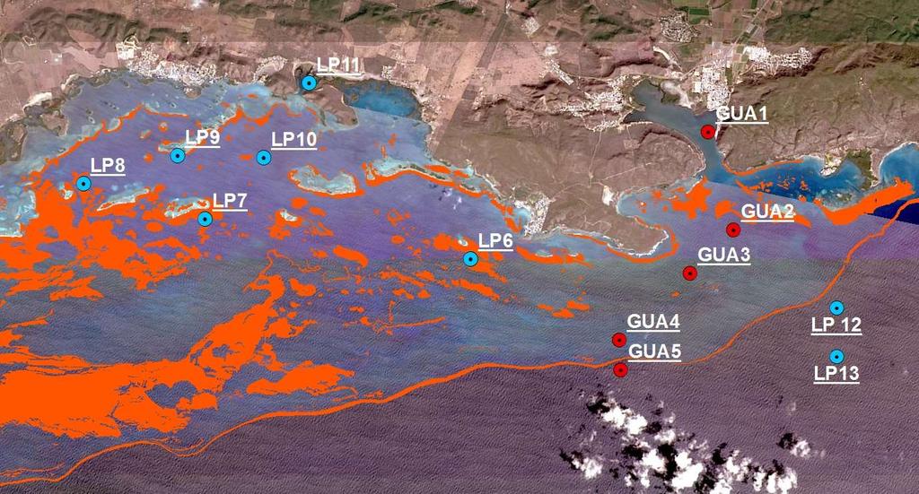
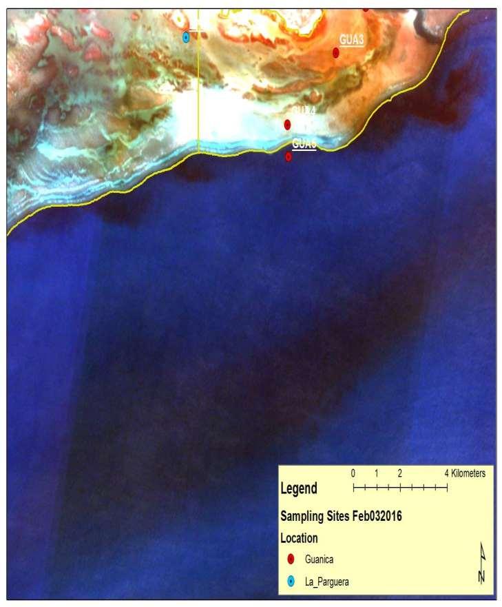
8 Guánica and La Parguera Area (Puerto Rico).
9
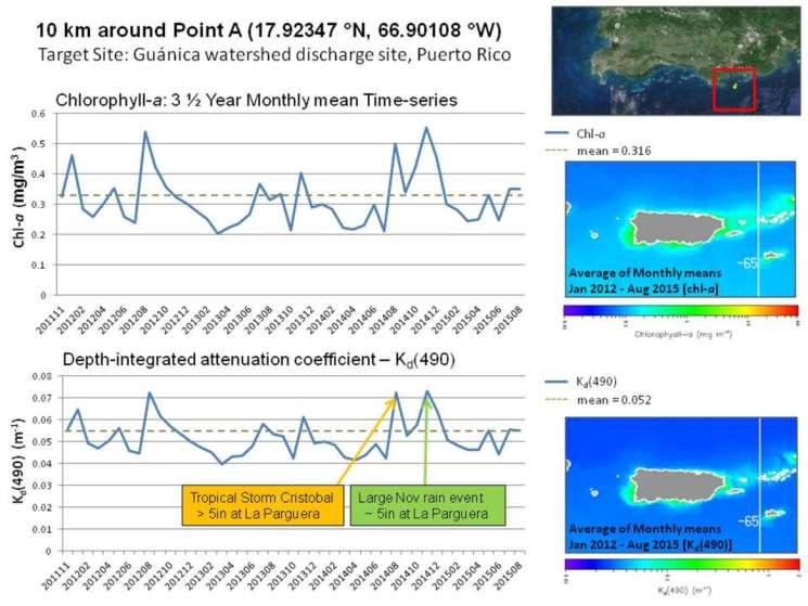
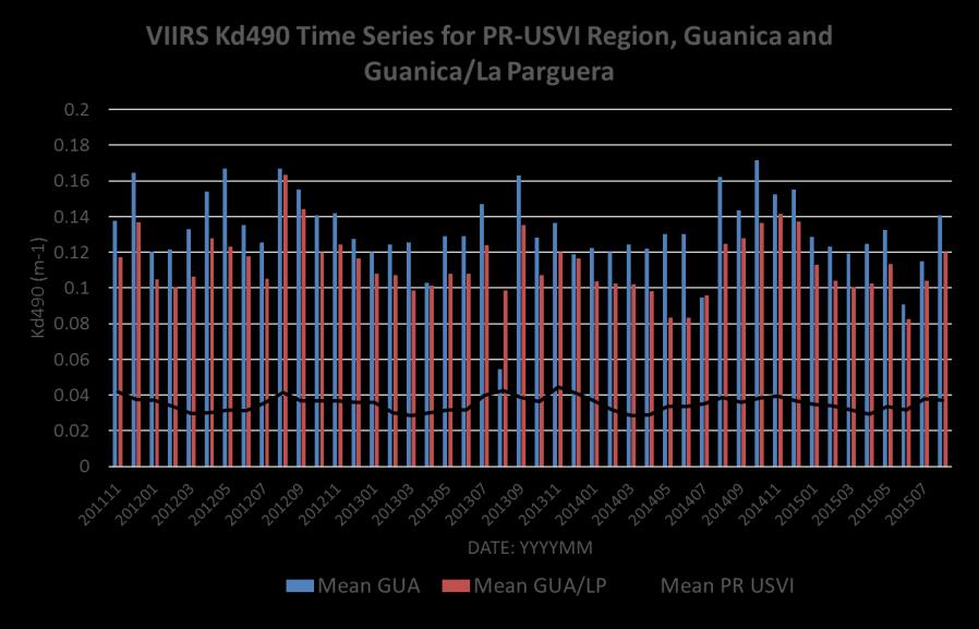
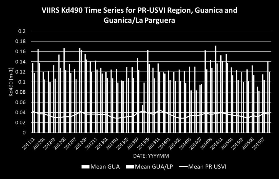
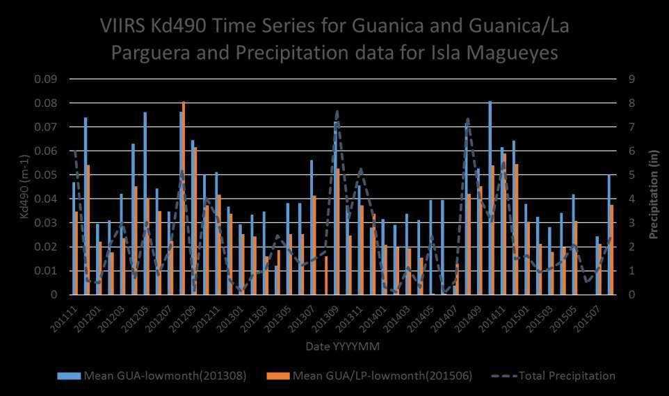
10 Matching large rainfall events to satellite derived measurements. Chlorophyll-a (Chl-a) Kd(490) Virtual Areas Establishing virtual areas around watersheds will enable calculation of plume statistics such as: Maximum and average levels of Chl-a and Kd(490) Monthly climatologies Variations from normal levels through time. (Anomalies).
11 Images credit: NOAA/NESDIS/STAR/CRW
12
13
14
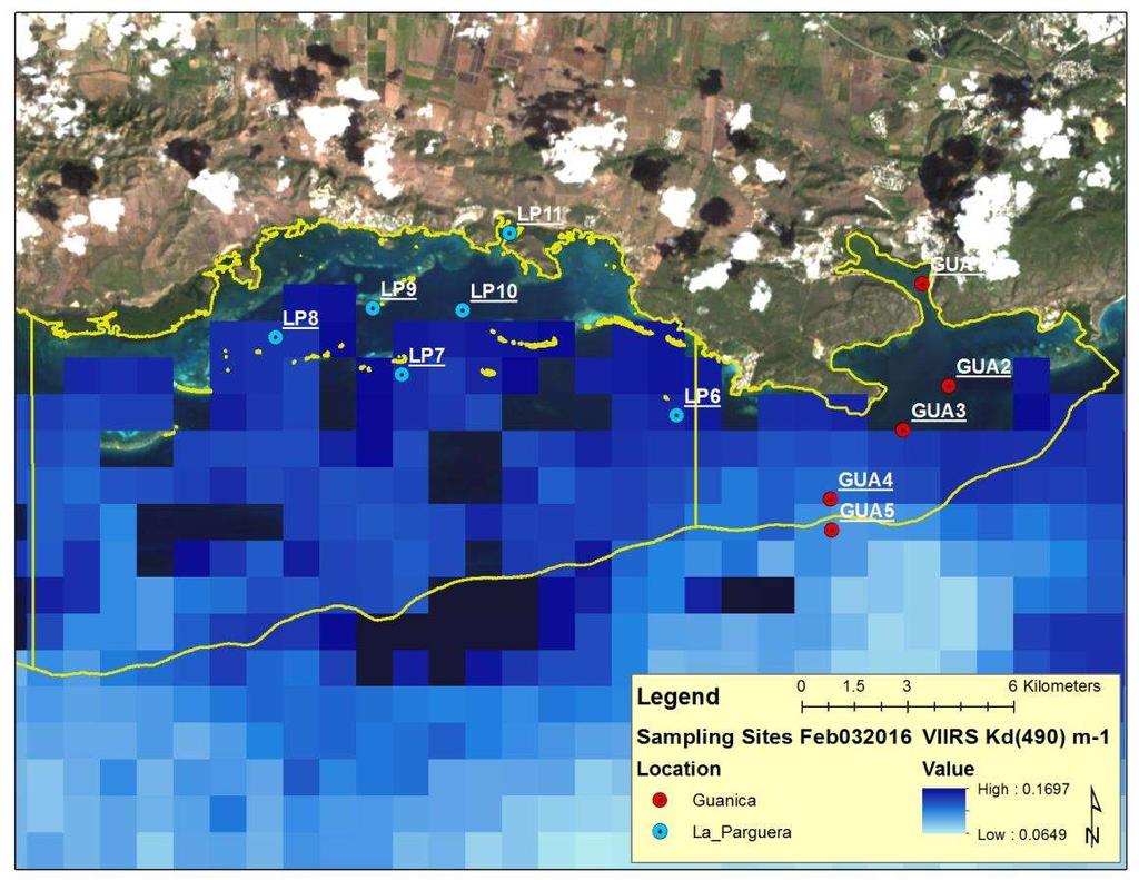
15 Percent (%) Results VIIRS Kd(490) (Daily) VIIRS Image % with pixel data Total Dates = Shelf Ocean Cabo Rojo Lajas Guánica

")
 SolarLight Datalogging")
")

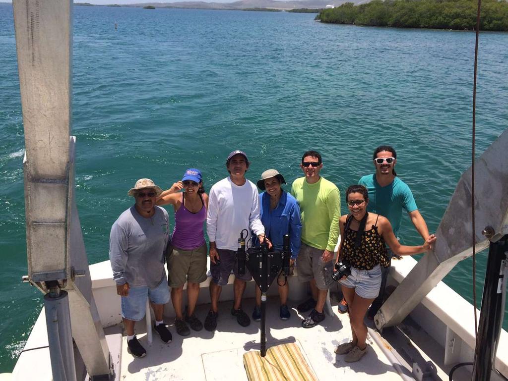
16 Simultaneous with Landsat 8 OLI image capture Instruments Satlantic Hyperpro Profiling radiometer (Lu, Ed, Rrs, Lw, Kd) GER 1500 Spectro-radiometer (Lw, Ed, Rrs) SolarLight Datalogging Radiometer (PAR) Hydroscat-6 (backscattering, flourescense) SCUFA (flourescense, turbidity) Water quality samples CHL, TSS, CDOM Hydroscat-6 GER1500 SCUFA
17
18
19 Kd (m-1) 0.14 Kd (490) values for selected stations from VIIRS pixel value and Satlantic in situ sampling GUA4 GUA5 LP6 LP7 LP8 Stations Kd490_VIIRS Kd490_Satlantic
20


21 Satlantic surface remote sensing reflectance Guanica bay Biobay Guanica bay Biobay Oceanic Oceanic
22
23
24
25
26

 Extend support to Hawai i and American Samoa.")
27 Local Ocean Color/LSD/SST Continued cal/val data for VIIRS for Guanica and La Parguera. (July- December) Integrate higher-resolution sensor products with field data.(e.g. Landsat 8 OLI,Sentinel-3 OLCI) Extend support to Hawai i and American Samoa. New instruments EcoPAR, SBE 39plus Temperature (P) Recorder. EcoPAR SBE 56
28
29 QUESTIONS? Contact: bio-optics.uprm.edu y was supported and monitored by National Oceanic and Atmospheric Adm (NOAA) under NOAA CREST-EPP Grant # NA11SEC For REFERENCES please contact presenter.
NEW WEB TOOL FOR UNDERSTANDING BIOLUMINESCENT BAYS
 NEW WEB TOOL FOR UNDERSTANDING BIOLUMINESCENT BAYS Fernando Gilbes Santaella* and William Hernandez GERS Lab-Department of Geology University of Puerto Rico at Mayaguez *fgilbes@uprm.edu RESEARCH COMPONENT
U.S. Activities in Puerto Rico, U.S. Virgin Islands and the Wider Caribbean. NOAA and the US Coral Reef Task Force
 U.S. Activities in Puerto Rico, U.S. Virgin Islands and the Wider Caribbean NOAA and the US Coral Reef Task Force U.S. Coral Reef Task Force Co-Chairs: National Oceanic and Atmospheric Administration (NOAA)
Coverage of Mangrove Ecosystem along Three Coastal Zones of Puerto Rico using IKONOS Sensor
 Coverage of Mangrove Ecosystem along Three Coastal Zones of Puerto Rico using IKONOS Sensor Jennifer Toledo Rivera Geology Department, University of Puerto Rico, Mayagüez Campus P.O. Box 9017 Mayagüez,
Using Gliders to Resolve Dynamics of Dust and Phytoplankton in the Mediterranean
 Using Gliders to Resolve Dynamics of Dust and Phytoplankton in the Mediterranean Oscar M. E. Schofield Institute of Marine and Coastal Sciences 71 Dudley Road Rutgers University New Brunswick, NJ 08901
Integration Of Reflectance To Study Glacier Surface Using Landsat 7 ETM+: A Case Study Of The Petermann Glacier In Greenland
 Integration Of Reflectance To Study Glacier Surface Using Landsat 7 ETM+: A Case Study Of The Petermann Glacier In Greenland Félix O. Rivera Santiago Department Of Geology, University Of Puerto Rico, Mayaguez
% farmers/private landowners in watershed applying BMPs. Other (Number of participants completed the training)
") Easygrants ID: 23803 National Fish and Wildlife Foundation NFWF/Legacy Grant Project ID: 0302.10.023803 U. S. Coral Reef Task Force Partnership Initiative 2010 - Submit Final Programmatic Report (Activities
Easygrants ID: 23803 National Fish and Wildlife Foundation NFWF/Legacy Grant Project ID: 0302.10.023803 U. S. Coral Reef Task Force Partnership Initiative 2010 - Submit Final Programmatic Report (Activities
Using Gliders to Resolve Dynamics of Dust and Phytoplankton in the Mediterranean
 DISTRIBUTION STATEMENT A. Approved for public release; distribution is unlimited. Using Gliders to Resolve Dynamics of Dust and Phytoplankton in the Mediterranean Oscar M. E. Schofield and Scott Glenn
The use of HICO in the Southern Benguela: Saldanha Bay case study
 The use of HICO in the Southern Benguela: Saldanha Bay case study Marié Smith 1, Stewart Bernard 2, Hayley Evers-King 1 1. Department of Oceanography, University of Cape Town, South Africa 2. Council for
Paul Sturm Roberto Viqueira Ríos
 Paul Sturm Roberto Viqueira Ríos In this talk Brief Background on Land Based Sources Historical Perspective Guánica watershed characteristics/ issues High priority restoration projects Other key issues
Gliders and Autonomous Underwater and Surface Vehicles
 Gliders and Autonomous Underwater and Surface Vehicles There are many different types of autonomous vehicles available commercially as monitoring platforms in the marine environment. For a sustained monitoring
Cal/Val Activities at the CIGSN Uardry Field Site, NSW, Australia in Support of the EO-1 Mission
 Cal/Val Activities at the CIGSN Uardry Field Site, NSW, Australia in Support of the EO-1 Mission Fred Prata and Graham Rutter CSIRO Atmospheric Research David Jupp CSIRO Earth Observation Centre EOC Annual
Contaminant and Erosion Control Baseline Database for the Puerto Mosquito Watershed In Vieques,, Puerto Rico
 Contaminant and Erosion Control Baseline Database for the Puerto Mosquito Watershed In Vieques,, Puerto Rico Fernando Gilbes, Principal Investigator UPRM-Geology, gilbes@cacique.uprm.edu Roy Armstrong,
Deepwater Horizon Oil Spill Principal Investigator One Year Update Workshop
 Deepwater Horizon Oil Spill Principal Investigator One Year Update Workshop Wave Glider Monitoring the Gulf of Mexico Graham Hine Senior Vice President of Operations Liquid Robotics, Inc. 25 October, 2011
Retreating Glaciers of the Himalayas: A Case Study of Gangotri Glacier Using Satellite Images
 Retreating Glaciers of the Himalayas: A Case Study of Gangotri Glacier Using 1990-2009 Satellite Images Jennifer Ding Texas Academy of Mathematics and Science (TAMS) Mentor: Dr. Pinliang Dong Department
Platform and Products
 International Partnership Space Programme Earth Observation for the Preservation of Ecological Bacalar Corridor Platform and Products Terri Freemantle, Raffaella Guida, Paula Marti, Pasquale Iervolino
Population Composition, Geographic Distribution, and Natural Hazards: Vulnerability in the Coastal Regions of Puerto Rico
 Population Composition, Geographic Distribution, and Natural Hazards: Vulnerability in the Coastal Regions of Puerto Rico Researchers Havidán Rodríguez, Ph.D. (DRC-UDel) Walter Díaz, Ph. D. (CISA-UPRM)
Prévision opérationnelle de trajectoires de gliders en mission
 Prévision opérationnelle de trajectoires de gliders en mission P. Testor et al. CNRS/LOCEAN, Paris, France Colloque LEFE, 30 mars 2017, Clermont-Ferrand Gliders: steered profiling floats Data centers users
GCRMN: An evolving approach for coral reef monitoring to support ICRI, management & policy
 GCRMN: An evolving approach for coral reef monitoring to support ICRI, management & policy Jeremy B.C. Jackson, Science Director, GCRMN Andy Hooten Global Coordinator, GCRMN Vivian Lam Deputy Coordinator,
Japan Earthquake and Tsunami: a view from satellite data
 Università degli studi di Roma Tor Vergata Corso di Telerilevamento e Cartografia Anno accademico 2012/2013 Japan Earthquake and Tsunami: a view from satellite data Dr. Matteo Picchiani picchiani@disp.uniroma2.it
Coral reefs facing to global and regional environmental changes
 Coral reefs facing to global and regional environmental changes Hiroya Yamano (National Institute for Environmental Studies) Importance of coral reefs Photo: H. Kan Photo: H. Kayanne Biodiversity Fisheries
PUERTO RICO. Puerto Rico S Coral Reef Management Priorities PUERTO RICO S CORAL REEF MANAGEMENT PRIORITIES
 PUERTO RICO PUERTO RICO S CORAL REEF MANAGEMENT PRIORITIES Puerto Rico S Coral Reef Management Priorities I PUERTO RICO S CORAL REEF MANAGEMENT PRIORITIES The Commonwealth of Puerto Rico and NOAA Coral
Using of space technologies for glacierand snow- related hazards studies
 United Nations / Germany international conference on International Cooperation Towards Low-Emission and Resilient Societies Using of space technologies for glacierand snow- related hazards studies Bonn,
Coral Reefs: Integrative Teaching Tool (and Guide to NOAA Resources) National Science Teachers Association April 6, 2006 Anaheim, California
 National Science Teachers Association April 6, 2006 Anaheim, California") Coral Reefs: Integrative Teaching Tool (and Guide to NOAA Resources) National Science Teachers Association April 6, 2006 Anaheim, California NOAA Coral Reef Conservation Program: Created by NOAA in 2000
Coral Reefs: Integrative Teaching Tool (and Guide to NOAA Resources) National Science Teachers Association April 6, 2006 Anaheim, California NOAA Coral Reef Conservation Program: Created by NOAA in 2000
Strategies for the design, development and implementation of Marine Protected Areas in Puerto Rico under the Caribbean Coral Reef Institute
 Strategies for the design, development and implementation of Marine Protected Areas in Puerto Rico under the Caribbean Coral Reef Institute La Parguera, August 4, 2006 Manuel Valdes Pizzini Interdisciplinary
FERNANDO GILBES-SANTAELLA DEPARTMENT OF GEOLOGY UNIVERSITY OF PUERTO RICO AT MAYAGÜEZ MAYAGÜEZ, PUERTO RICO
 FERNANDO GILBES-SANTAELLA DEPARTMENT OF GEOLOGY UNIVERSITY OF PUERTO RICO AT MAYAGÜEZ MAYAGÜEZ, PUERTO RICO 00681-9000 PHONE: (787) 832-4040 Ext. 3000 FAX: (787) 265-3845 EMAIL: fernando.gilbes@upr.edu
MARINA BOLADO PENAGOS A METHODOLOGY TO ASSESS THE ROLE OF THE RIVER DISCHARGES TO THE GULF OF CADIZ ON THE NUTRIENT SUPPLY TO THE ALBORAN SEA
 MARINA BOLADO PENAGOS A METHODOLOGY TO ASSESS THE ROLE OF THE RIVER DISCHARGES TO THE GULF OF CADIZ ON THE NUTRIENT SUPPLY TO THE ALBORAN SEA INTRODUCTION General MEGAN Project Case Study Guadalquivir
Estuaries of South America
 Gerardo M.E. Perillo Maria Cintia Piccolo Mario Pino-Quivira (Eds.) Estuaries of South America Their Geomorphology and Dynamics With 102 Figures and 20 Tables Springer 1 What Do We Know About the Geomorphology
Mechanisms Controlling Hypoxia: Integrated Coastal Modeling Field Year 2010
 Mechanisms Controlling Hypoxia: Integrated Coastal Modeling Field Year 2010 Survey cruises on R/V Manta The cruises decribed Dates of cruises: 14 19 June 2010, one half day mobilization. 1 6 August 2010,
Guánica Bay Watershed
 P A R T N E R S H I P F O R T H E GUÁ N I C A B A Y W A T E R S H E D October 15, 2010 Volume 1, Issue 1 Guánica Bay Watershed update Inside this issue: NFWF Grants 2 Personnel Updates 3 Webinar 4 Community
The Regional Coral Reef Task Force and Action plan. 27 th ICRI. Cairns Australia July 2012
 The Regional Coral Reef Task Force and Action plan 27 th ICRI Cairns Australia July 2012 Western Indian Ocean Region East Africa mainland states Indian Ocean Islands states Biogeographic division of the
EVALUATION OF DIFFERENT METHODS FOR GLACIER MAPPING USING LANDSAT TM
 EVALUATION OF DIFFERENT METHODS FOR GLACIER MAPPING USING LANDSAT TM Frank Paul Department of Geography, University of Zurich, Switzerland Winterthurer Strasse 190, 8057 Zürich E-mail: fpaul@geo.unizh.ch,
SPATIO TEMPORAL CHANGE OF SELECTED GLACIERS ALONG KARAKORAM HIGHWAY FROM USING REMOTE SENSING AND GIS TECHNIQUES
 SPATIO TEMPORAL CHANGE OF SELECTED GLACIERS ALONG KARAKORAM HIGHWAY FROM 1994-217 USING REMOTE SENSING AND GIS TECHNIQUES Yasmeen Anwar 1, Javed Iqbal 2 1 National University of Sciences and Technology
In 2004, NOAA s Coral Reef Conservation Program provided funding and other support for activities in the following NOAA offices...
 In 2004, NOAA s Coral Reef Conservation Program provided funding and other support for activities in the following NOAA offices... National Ocean Service (NOS) Office of Response and Restoration National
Status of MERIS validation activities at BOUSSOLE
 Status of MERIS validation activities at BOUSSOLE David ANTOINE Laboratoire d Océanographie de Villefranche (L.O.V.), France MERIS, March 4, 2003 Funding Agencies / Supports European Space Agency Centre
Investigation on Development of Agricultural Monitoring System Using Satellite Data
 Investigation on Development of Agricultural Monitoring System Using Satellite Data Genya SAITO (1), Daisuke KUNII (1), Naoki ISHITSUKA (2) (1) Tohoku University, 1-1,Tsutsumidori Amamiya-machi Aoba-ku,
Lateral Coherence and Mixing in the Coastal Ocean: Adaptive Sampling using Gliders
 DISTRIBUTION STATEMENT A. Approved for public release; distribution is unlimited. Lateral Coherence and Mixing in the Coastal Ocean: Adaptive Sampling using Gliders R. Kipp Shearman Jonathan D. Nash James
TOWARDS SUSTAINABLE MANAGEMENT OF MARINE AND COASTAL HABITATS ASIA- PACIFIC DAY FOR THE OCEAN
 TOWARDS SUSTAINABLE MANAGEMENT OF MARINE AND COASTAL HABITATS WANNAKIAT THUBTHIMSANG PHUKET MARINE BIOLOGICAL CENTER, DMCR, THAILAND ASIA- PACIFIC DAY FOR THE OCEAN 20 NOVEMBER 2018, CONFERENCE ROOM 4,
Ocean Gliders and the Argo float program Breck Owens WHOI. for INMARTECH Conference, Oct 06
 Ocean Gliders and the Argo float program Breck Owens WHOI for INMARTECH Conference, Oct 06 A brief history The Argo float program Gliders - how they work Some results from gliders The Future Glider Lineage
COSMO-Coast. L Aquila. La Sapienza. Tor Vergata. Dipartimento di Architettura ed Urbanistica. Dipartimento di Informatica, Sistemi e Produzione,
 COSMO-Coast Tor Vergata Dipartimento di Informatica, Sistemi e Produzione, L Aquila Dipartimento di Architettura ed Urbanistica La Sapienza Dipartimento Ingegneria Civile, Edile ed Ambientale Introduction
Fig. 1. A Webb glider at the surface offshore Hawaii attracting fish.
 Using Webb gliders to maintain a sustained ocean presence O. Schofield, J. Kohut, S. Glenn COOL, Institute of Marine and Coastal Sciences, School of Environmental and Biological Sciences, Rutgers University
The Caribbean Marine Protected Managers Network and Forum (CaMPAM) M ENTO RSH I P PRO G RAM MENTOR BIOGRAPHIES
 M ENTO RSH I P PRO G RAM MENTOR BIOGRAPHIES") The Caribbean Marine Protected Managers Network and Forum (CaMPAM) M ENTO RSH I P PRO G RAM Mr. Majil is currently the MPA Coordinator for the country of Belize, a position he has held since 2002. He previously
The Caribbean Marine Protected Managers Network and Forum (CaMPAM) M ENTO RSH I P PRO G RAM Mr. Majil is currently the MPA Coordinator for the country of Belize, a position he has held since 2002. He previously
PRO LINE FUSION INTEGRATED AVIONICS SYSTEM. Pro Line Fusion on Gulfstream G280: Your direct path to see and access more.
 Pro Line Fusion on Gulfstream G280: Your direct path to see and access more. Starting with its baseline features, the Pro Line Fusion avionics in your Gulfstream PlaneView280 flight deck offer capabilities
Aquatic insect surveys at Mount Magazine State Park and Hobbs State Park Conservation Area with implementation of an educational component
 Aquatic insect surveys at Mount Magazine State Park and Hobbs State Park Conservation Area with implementation of an educational component Arkansas is home to a relatively large number of endemic invertebrates
Unmanned Aircraft Systems (UAS) at the Jornada Experimental Range
 at the Jornada Experimental Range") Unmanned Aircraft Systems (UAS) at the Jornada Experimental Range Al Rango and the Jornada UAS Flight Team: Connie Maxwell, Amy Slaughter, Andrea Laliberte, Chris Pierce, Dave Thatcher, Jim Lenz, and Craig
Unmanned Aircraft Systems (UAS) at the Jornada Experimental Range Al Rango and the Jornada UAS Flight Team: Connie Maxwell, Amy Slaughter, Andrea Laliberte, Chris Pierce, Dave Thatcher, Jim Lenz, and Craig
Janice Sendt Thales Underwater Systems, Thales Australia, 274 Victoria Road, Rydalmere nsw 2116 Australia
 AN ANALYSIS OF GLIDER data AS AN INPUT to A SONAR RANGE DEPENDENT ACOUSTIC PERFORMANCE PREDICTION MODEL Janice Sendt Thales Underwater Systems, Thales Australia, 274 Victoria Road, Rydalmere nsw 2116 Australia
Development of Sea Surface Temperature in the Baltic Sea in 2010
 HELCOM Baltic Sea Environment Fact Sheets 2011 1 Development of Sea Surface Temperature in the Baltic Sea in 2010 Authors: Herbert Siegel and Monika Gerth Baltic Sea Research Institute Warnemünde (IOW)
The 2nd Glacier Inventory of China
 The 2nd Glacier Inventory of China LIU Shiyin Guo Wanqin, Xu Junli, Shangguan Donghui, Wei Junfeng, Wu Lizong, Yu Pengchun, Li Jing, Liu Qiao State Key Laboratory of Cryospheric Sciences, Cold and Arid
Distribution of Mangroves along the Red Sea Coast of the Arabian Peninsula: Part 2. The Southern Coast of Western Saudi Arabia
 Distribution of Mangroves along the Red Sea Coast of the Arabian Peninsula: Part 2. The Southern Coast of Western Saudi Arabia M. Asif Khan, Arun Kumar*and Abdul Muqtadir Center for Petroleum and Minerals,
Saving Sharks Proposing a New Marine Protected Area
 Saving Sharks Proposing a New Marine Protected Area What would be the ideal characteristics of a marine protected area designed to conserve white sharks in the Pacific Ocean? Learning Objectives Describe
Guánica Bay Watershed Initiative
 Guánica Bay Watershed Initiative Prepared by Center for Watershed Protection For NOAA and PRDNER NOAA circulated plan to all agencies USDA/ NRCS entered As commitment to Coral Reef Task Force How did
C-RISe Coastal Risk Information Service UKSA International Partnership Programme
 C-RISe Coastal Risk Information Service UKSA International Partnership Programme D Cotton (SatOC), A Becker (NOC, University of Liverpool), V Byfield (NOC), F Calafat (NOC), N Dayoub (NOC), E Ash (SatOC),
Statistical Evaluation of BMP Effectiveness in Reducing Fecal Coliform Impairment in Mermentau River Basin
 Statistical Evaluation of BMP Effectiveness in Reducing Fecal Coliform Impairment in Mermentau River Basin Z.-Q. Deng 1 and H. Chowdhary 2 1 Assistant Professor, Department of Civil and Environmental Engineering,
Puerto Rico in the Aftermath of Hurricanes Irma and Maria Jason Bram, Officer Research Economist
 Puerto Rico in the Aftermath of Hurricanes Irma and Maria Jason Bram, Officer Research Economist March 7, 2018 The views expressed here are those of the presenter and do not necessarily represent those
A Conceptual Framework for Measuring the Exposure to Tsunamis of Puerto Rican Coastal Communities
 Meulaboh, Aceh A Conceptual Framework for Measuring the Exposure to Tsunamis of Puerto Rican Coastal Communities Jean-Edouard Faucher Saylisse Dávila, PhD Department of Industrial Engineering University
A high resolution glacier model with debris effects in Bhutan Himalaya. Orie SASAKI Kanae Laboratory 2018/02/08 (Thu)
") A high resolution glacier model with debris effects in Bhutan Himalaya Orie SASAKI Kanae Laboratory 2018/02/08 (Thu) Research flow Multiple climate data at high elevations Precipitation, air temperature
A high resolution glacier model with debris effects in Bhutan Himalaya Orie SASAKI Kanae Laboratory 2018/02/08 (Thu) Research flow Multiple climate data at high elevations Precipitation, air temperature
LAUNCH OF THE COASTAL ZONE MANAGEMENT TRUST
 A 60km stretch of coastline on the Yucatan Peninsula of Mexico is the testing ground for an idea that could protect fragile environments around the world: insuring coral reefs. The Economist World Ocean
If there is magic on this planet, it is contained in water.
 If there is magic on this planet, it is contained in water. Loren Eiseley ~ American philosopher and nature writer ~ b.1907 d.1977 Above: A swimmer rests in the X Keken Cenote underground pool in the town
Monitoring Destination Sustainability: The Case of Hawaii
 Monitoring Destination Sustainability: The Case of Hawaii by: Daniel M. Spencer, Ph.D. Professor of Tourism School of Travel Industry Management University of Hawaii at Manoa Honolulu, HI USA 96822 Paper
Retrieval of aerosol optical thickness and size distribution from the CIMEL Sun photometer over Inhaca Island, Mozambique
 JOURNAL OF GEOPHYSICAL RESEARCH, VOL. 108, NO. D13, 8509, doi:10.1029/2002jd002374, 2003 Retrieval of aerosol optical thickness and size distribution from the CIMEL Sun photometer over Inhaca Island, Mozambique
HIMIOFoTS - Hellenic Integrated Marine Inland water Observing, Forecasting and offshore Technology System
 HIMIOFoTS - Hellenic Integrated Marine Inland water Observing, Forecasting and offshore Technology System Leonidas Perivoliotis, Institute of Oceanography, Hellenic Center for Marine Research HIMIOFOTS
EGO: Everyone s Gliding Observatories
 EGO: Everyone s Gliding Observatories Pierre Testor LOCEAN, CNRS, Paris, France The Economist, 2012/06/09 OCG-5, September 2013 EGO: gliders capabilities Land Station Data Centers Scientific/ operational
Glacial lakes as sentinels of climate change in Central Himalaya, Nepal
 Glacial lakes as sentinels of climate change in Central Himalaya, Nepal Sudeep Thakuri 1,2,3, Franco Salerno 1,3, Claudio Smiraglia 2,3, Carlo D Agata 2,3, Gaetano Viviano 1,3, Emanuela C. Manfredi 1,3,
Net of Innovation. July 2015 Dave Finger, Mark Foster
 Net of Innovation July 2015 Dave Finger, Mark Foster Table of Contents The Challenges and Solutions to Safe Outdoor Testing... 2 Types of Testing a Netted Enclosure Enables... 4 Flight Plan Testing...
FECAL COLIFORM MONITORING IN GRAYS HARBOR COUNTY: SUMMARY REPORT OF MONITORING RESULTS FOR
 Chehalis Basin Partnership Fecal Coliform Monitoring in Grays Harbor County: Summary Report of Monitoring Results for 2000-2003 Draft June 30, 2003 Prepared by Tetra Tech/KCM, Inc. 1917 First Avenue, Seattle,
Considerations for the Long-Term Atmospheric Observing Network
 Considerations for the Long-Term Atmospheric Observing Network 1. Land Cover / Land Use & Change 2. Spatial & temporal scale of climate anomalies 3. Climatological wind patterns 4. Expected signals vs.
Monitoring of Mountain Glacial Variations in Northern Pakistan, from 1992 to 2008 using Landsat and ALOS Data. R. Jilani, M.Haq, A.
 Monitoring of Mountain Glacial Variations in Northern Pakistan, from 1992 to 2008 using Landsat and ALOS Data R. Jilani, M.Haq, A. Naseer Pakistan Space & Upper Atmosphere Research Commission (SUPARCO)
Spatial Assessment for the revised Mpumalanga Biodiversity Expansion Strategy. Mervyn Lotter Scientific Services 8 June 2016
 Spatial Assessment for the revised Mpumalanga Biodiversity Expansion Strategy Mervyn Lotter Scientific Services 8 June 2016 Mpumalanga Protected Area Expansion Strategy (MPAES) Developed our first MPAES
Potential of CO 2 retrieval from IASI
 Potential of CO 2 retrieval from IASI L. Chaumat, O. Lezeaux, P. Prunet, B. Tournier F.-R. Cayla (SISCLE), C. Camy-Peyret (LPMAA) and T. Phulpin (CNES) Study supported by CNES ITSC-XVI: Angra dos Reis,
SEDAR57-DW June 2018 Updated: 26 July 2018
 Inventory of Fishery-Independent Programs and Survey Data Available for Stock Assessment of Caribbean Spiny Lobster in the US Caribbean Skyler Sagarese, William Harford, Aida Rosario, Matt Johnson and
DETECTION OF ICE FRONT INITIATION ON THE PEACE RIVER IN NORTHERN ALBERTA Freeze-up
 FINAL REPORT DETECTION OF ICE FRONT INITIATION ON THE PEACE RIVER IN NORTHERN ALBERTA Freeze-up 2013-2014 REFERENCE NO. CO 73797 Presented to: British Columbia Hydro and Power Authority Prepared by: Monique
Regional Economic Conditions
 Regional Economic Conditions Jason Bram, Research Officer Community Advisory Group Meeting March 29, 2018 The views expressed here are those of the presenter and do not necessarily represent those of the
Vision for Development of Georgia's High Mountainous Regions adapted to the Climate and Landscape Changes
 Vision for Development of Georgia's High Mountainous Regions adapted to the Climate and Landscape Changes George Gotsiridze 3rd EURO-ASIAN MOUNTAIN RESORTS CONFERENCE 4-7 April, 2017, Tbilisi, Georgia
Total suspended particles and solar radiation over Cairo and Aswan
 Renewable Energy 23 (2001) 605 619 www.elsevier.nl/locate/renene Total suspended particles and solar radiation over Cairo and Aswan M.A. Mosalam Shaltout *, A.H. Hassan, A.M. Fathy National Research Institute
C. Area of operation: Columbia River and Columbia River Estuary between mouth of estuary and Portland, Oregon.
 R/V Barnes Cruise Plan July 2008 Cruise dates: July 7 24 Captain: Ray McQuin Lead scientist: Joseph Needoba (needobaj@stccmop.org) Funding source: NSF PI Antonio Baptista Organization: NSF Center for Coastal
Presenter : Dodin/Jean-Paul, Jeremie
 Presenter : Dodin/Jean-Paul, Jeremie Seychelles National Meteorological Services Seychelles International Airport Ministry of Environment & Energy Environment Department P.O Box 1145 Victoria Mahe Tel:
Underwater Acoustic Monitoring in US National Parks
 Underwater Acoustic Monitoring in US National Parks Megan F McKenna 1, Christopher Garsha 2, Erik Stabenau 1, Christine Gabriele 1, Timothy Clark 1, Clayton Pollock 1, Brinnen Carter 1, Samantha Bietsch
FIFI-LS. Status Report. Randolf Klein USRA
 FIFI-LS Status Report Randolf Klein USRA S. Colditz, C. Fischer, F. Fumi, N.Geis, R. Hönle, A. Krabbe, L. Looney, A. Poglitsch, W. Raab, F. Rebell, M. Savage 1 2 Outline FIFI-LS overview Instrument status
In-field and Remote Sensing for Precision Agriculture. John Nowatzki Extension Ag Machine Systems Specialist North Dakota State University
 In-field and Remote Sensing for Precision Agriculture John Nowatzki Extension Ag Machine Systems Specialist North Dakota State University UAS in Precision Agriculture In-field Sensors Selecting UAS Equipment
Preliminary Results from the ATHENA-OAWL Venture Tech Airborne Mission
 Preliminary Results from the ATHENA-OAWL Venture Tech Airborne Mission Sunil Baidar (a, b), Sara Tucker (c), Mike Hardesty (a, b) (a) CIRES, University of Colorado Boulder, Boulder, CO (b) NOAA Earth System
Development of Sea Surface Temperature in the Baltic Sea in 2009
 Development of Sea Surface Temperature in the Baltic Sea in 2009 Authors: Herbert Siegel and Monika Gerth, Baltic Sea Research Institute Warnemünde (IOW) Key message The development of the sea surface
Predicting Impacts of Stressors at the Land-Water Interface
 Predicting Impacts of Stressors at the Land-Water Interface Chesapeake Bay and Delmarva Coastal Bays NOAA Support $4.8M for 5 Years Starting September 2009 17 Principal Investigators, 8 Institutions, led
DISTRIBUTION OF CHILEAN JACK MACKEREL EGGS AND LARVAE IN THE SOUTHEASTERN PACIFIC OCEAN CHILEAN JACK MACKEREL WORKSHOP (CHJMWS)
") INSTITUTO DE INVESTIGACIÓN PESQUERA DISTRIBUTION OF CHILEAN JACK MACKEREL EGGS AND LARVAE IN THE SOUTHEASTERN PACIFIC OCEAN Sergio Núñez, Sebastián Vásquez, Patricia Ruiz & Aquiles Sepúlveda Instituto
INSTITUTO DE INVESTIGACIÓN PESQUERA DISTRIBUTION OF CHILEAN JACK MACKEREL EGGS AND LARVAE IN THE SOUTHEASTERN PACIFIC OCEAN Sergio Núñez, Sebastián Vásquez, Patricia Ruiz & Aquiles Sepúlveda Instituto
Airborne Remote Sensing Component of Marine Debris Monitoring
 Airborne Remote Sensing Component of Marine Debris Monitoring Dr. Thomas H Mace Mace Geospatial, LLC Workshop on Mission Concepts for Marine Debris Sensing Honolulu, Hi, Jan 19 21, 2016 Multistage Remote
ReefFix. May, For the Organization of American States (OAS) and the Inter-American Biodiversity Information Network (IABIN)
 and the Inter-American Biodiversity Information Network (IABIN)") Fondation pour la Protection de la Biodiversité Marine FoProBiM B.P. 642 www.foprobim.org (mail) 6011 Henning St. Port-au-Prince, Haiti Bethesda, MD 20817 ReefFix Rapid Assessment of the Economic Value
Fondation pour la Protection de la Biodiversité Marine FoProBiM B.P. 642 www.foprobim.org (mail) 6011 Henning St. Port-au-Prince, Haiti Bethesda, MD 20817 ReefFix Rapid Assessment of the Economic Value
Adapting to climate change by promoting sustainable livelihoods, human and food security, and resilient ecosystems
 Adapting to climate change by promoting sustainable livelihoods, human and food security, and resilient ecosystems ICRI Indian Ocean Day December 13, 2011 Regional Challenges Atlantic Caribbean Challenge
(No. 9) (Approved April 8, 2001) AN ACT
 (Approved April 8, 2001) AN ACT") (S. B. 148) (No. 9) (Approved April 8, 2001) AN ACT To establish the Puerto Rico National Parks System, establish its objectives, its administration, the powers and duties of the Executive Director of
(S. B. 148) (No. 9) (Approved April 8, 2001) AN ACT To establish the Puerto Rico National Parks System, establish its objectives, its administration, the powers and duties of the Executive Director of
MARINE PROTECTED AREA IN MALAYSIA
 MARINE PROTECTED AREA IN MALAYSIA AB RAHIM GOR YAMAN Director, Division of Planning and Management Department of Marine Park Ministry of Natural Resources and Environment abrahim@nre.gov.my History of
Pantanal Tri-National GIS and Remote Sensing Pilot Project Case Study for Bolivia, Brazil, and Paraguay
 Six Ramsar remote sensing case studies were developed in 2002 as part of the NASA Socioeconomic Data and Application Center's (SEDAC) Ramsar Wetlands Data Gateway, developed in support of the Ramsar Convention
Preliminary investigation of alternative approaches for the Reef Plan Report Card Water Quality Metric
 Preliminary investigation of alternative approaches for the Reef Plan Report Card Water Quality Metric Authors: Dieter Tracey, Jane Waterhouse and Eduardo da Silva TropWATER Report 16/63 July 2016 Preliminary
CRYOSPHERE ACTIVITIES IN SOUTH AMERICA. Bolivia. Summary
 WORLD METEOROLOGICAL ORGANIZATION GLOBAL CRYOSPHERE WATCH (GCW) CryoNet South America Workshop First Session Santiago de Chile, Chile 27-29 October 2014 GCW-CNSA-1 / Doc. 3.1.2 Date: 20 October 2014 AGENDA
Great Lakes Association of Science Ships Annual Meeting, Traverse City, MI 11 Jan 11
 Great Lakes Association of Science Ships Annual Meeting, Traverse City, MI 11 Jan 11 Dr. Marie Colton Director NOAA Great Lakes Environmental Research Lab Ann Arbor, MI Dennis Donahue Marine Superintendent
Land-Use and Water Quality Across the Cape Fear River Basin, NC: from 2001 to Jennifer Braswell Alford, PhD
 Land-Use and Water Quality Across the Cape Fear River Basin, NC: Exploring Spatial and Temporal Relationships from 2001 to 2006 Jennifer Braswell Alford, PhD Introduction There are over 3.6 million miles
DOWNLOAD OR READ : MANUEL ANTONIO OCEAN TEMPERATURE PDF EBOOK EPUB MOBI
 DOWNLOAD OR READ : MANUEL ANTONIO OCEAN TEMPERATURE PDF EBOOK EPUB MOBI Page 1 Page 2 manuel antonio ocean temperature manuel antonio ocean temperature pdf manuel antonio ocean temperature Academia.edu
The Regional Coral Reef Task Force and Action plan. Indian Ocean Day. Reunion December 2011
 The Regional Coral Reef Task Force and Action plan Indian Ocean Day Reunion December 2011 Western Indian Ocean Region East Africa mainland states Indian Ocean Islands states Biogeographic division of the
Appendix A. PHYSICAL, SOCIAL, AND ECONOMIC STATISTICS
 Appendix A. PHYSICAL, SOCIAL, AND ECONOMIC STATISTICS FOR THE CARIBBEAN REGION TABLE A1. CORAL REEF AREA IN THE WIDER CARIBBEAN Estimates of Coral Reef Area Reefs at Risk in the World Atlas of Coral Reefs
State of Oceans and Coasts: Philippines
 State of Oceans and Coasts: Philippines Nilda Baling Department of Environment and Natural Resources (DENR) Romeo Recide Philippine Statistics Authority Ocean economy GROSS VALUE ADDED OF OCEAN-BASED ACTIVITIES
Using the Sentinels to map the state and changes of Norwegian glaciers
 /Copernicus Sentinel / Using the Sentinels to map the state and changes of Norwegian glaciers Liss Marie Andreassen, Solveig H. Winsvold, Andreas Kääb, Alexandra Messerli, Geir Moholdt, Suruchi Engelhardt,
EO technologies for flood mapping and hydrological modelling in Namibia
 Satellite Earth Observation & Disaster Risks EO technologies for flood mapping and hydrological modelling in Namibia Guido Van Langenhove, Hydrological Services Namibia Hydrological trends in Namibia:
LAUNCHING YOUR UNMANNED AIRCRAFT PROGRAM
 LAUNCHING YOUR UNMANNED AIRCRAFT PROGRAM THE DARTDRONES TEAM UNMANNED AIRCRAFT APPLICATIONS AERIAL INSPECTIONS AERIAL INSPECTIONS Safer and faster alternative to visual inspection by an individual Damage
UAS to GIS Utilizing a low-cost Unmanned Aerial System (UAS) for Coastal Erosion Monitoring
 for Coastal Erosion Monitoring") UAS to GIS Utilizing a low-cost Unmanned Aerial System (UAS) for Coastal Erosion Monitoring Agenda Scope of today s presentation Demonstration Objectives Wrightsville Beach Test Area Masonboro Inlet Jetties
UAS to GIS Utilizing a low-cost Unmanned Aerial System (UAS) for Coastal Erosion Monitoring Agenda Scope of today s presentation Demonstration Objectives Wrightsville Beach Test Area Masonboro Inlet Jetties