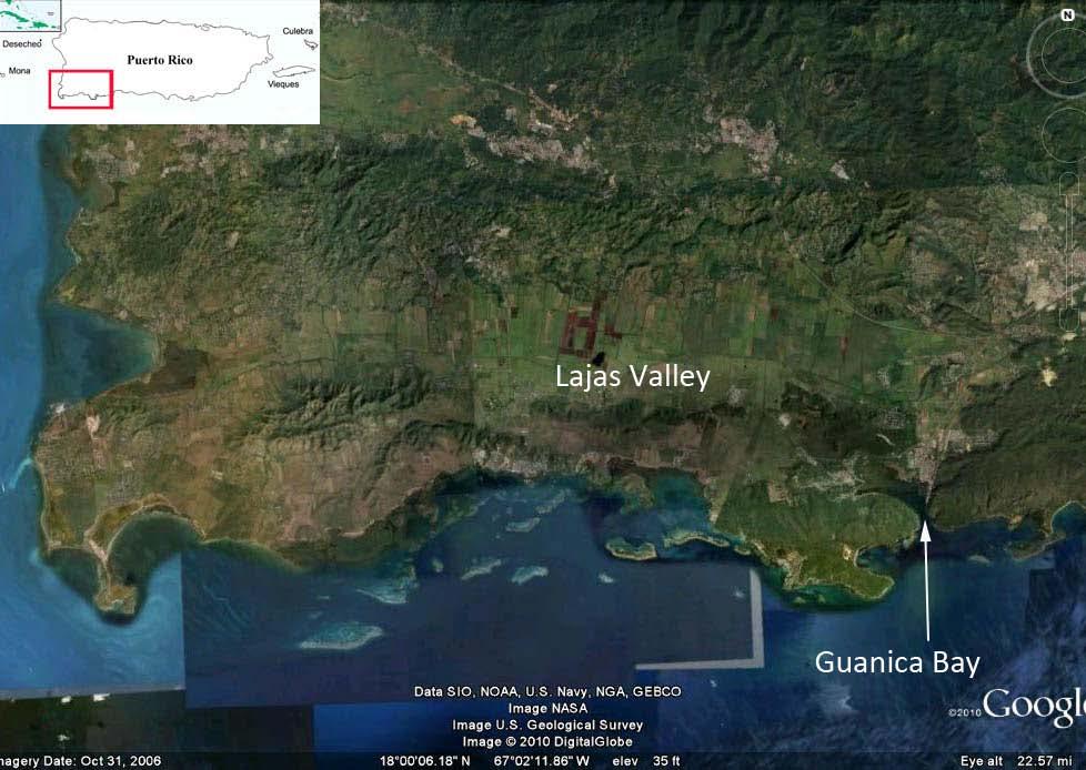
Guánica Bay Watershed Initiative
|
|
|
- Clementine Lilian Mason
- 5 years ago
- Views:
Transcription
1 Guánica Bay Watershed Initiative Prepared by Center for Watershed Protection For NOAA and PRDNER NOAA circulated plan to all agencies USDA/ NRCS entered As commitment to Coral Reef Task Force
2
3 How did this evolve? NRCS letter from Chief to agencies challenging them to join in the Guánica Watershed initiative NRCS provided funding ($250K in seed funds) Committed $1 Million in FY10 to agricultural practices Asked for 5 year commitment from all agencies Other agencies responded according to their available programs, funding limitations, and staff
4 Current Partners USDA/NRCS NOAA FWS EPA PR Dept. of Natural and Environmental Resources Center for Watershed Protection National Fish & Wildlife Foundation Municipality of Yauco Municipality of Guánica University of Puerto Rico Lajas Valley Farmers Envirosurvey, Inc. Local NGOs PR Land Authority PR Land Administration PR Electric Power Authority PR Aqueduct & Sewer Authority PR Dept. of Agriculture Agricultural Extension Service
5 Large Groups/ Large Plans Advantages Greater funding resources Broad expertise Greater public buyin and involvement More robust plan Complications Conflicting goals and hidden agendas Stagnation through indecision Division and coordination of work Logistical complications So how is this working?
 In-stream channel erosion 4) Loss of Historic Laguna de Guánica 5) Legacy contaminants 6) Sewage")
6 Guánica Bay Watershed Plan Issues: 1)Upland erosion in the coffee growing regions 2) Reservoir sedimentation and transport 3) In-stream channel erosion 4) Loss of Historic Laguna de Guánica 5) Legacy contaminants 6) Sewage treatment.
 Legacy contaminants 6) Sewage treatment improve Guánica WWTP Define what can be worked with Define where your agency/entity best")
7 Guánica Watershed Initiative 1)Upper Watershed - Upland erosion in the coffee growing regions 2) Reservoir sedimentation and transport 3) In-stream channel erosion 4) Loss of Historic Guánica Lagoon - Possible restoration 5) Legacy contaminants 6) Sewage treatment improve Guánica WWTP Define what can be worked with Define where your agency/entity best fits

8 Upper Watershed Rio Yahuecas (above dam) Rio Prieto (above dam) Rio Guayo (above dam) Watershed includes east Lajas Valley, Rio Loco, and associated watersheds. Western Lajas Valley drains to Laguna Cartagena NWR. The Loco Valley Watershed is a highly managed system including: 5 reservoirs 2 hydropower plants irrigation drainage systems. Upper Loco (above dam) Upper Yauco (above Luchetti)


9 Upper Watershed Why not just the Rio Loco Watershed? Why is it called the Rio Loco? Loco Reservoir receives major water supply from Luchetti through the hydropower system Major event rainfall is diverted from Luchetti to Loco as rapidly as possible Excess flows out through the Rio Loco with a lot of fine sediments


10 Coordinate within your own agency/group Sun to Shade Coffee Initiative Started with PFW Program Agro-forestry practice Adapted for certain watersheds for Coastal Program Practice adopted by NRCS /EQIP Use or adapt tools you already have


 Shade")


11 Sun to Shade Coffee Initiative Sun Coffee (slopes may be > 45 o ) Shade Coffee Model Interagency Habitat Conservation Working Group


 Envirosurvey, Inc.")


 No till")

12 Coordination with Partners MOU with NRCS to promote practice in coffee farms. FWS detail with NRCS (S.Padron & R. Colon) Envirosurvey, Inc. - Providing technical assistance & seedling trees Additional NRCS practices included Contour planting of coffee (new farms) No till Nutrient/chemical management Soil testing Need to adapt existing access road practice for PR farms


13 Yauco and Maricao Sun Coffee Farms FY10 Farms in red are with a combination of FWS and NRCS funds Farms in yellow are FWS funds only Included both Coastal and Partners for Fish and Wildlife Programs NRCS used EQIP practice funding
14 Progress for FY10 and Future Plans Total Acres Trees Pace the work to your and your Partners limitations Enrolled 17 farms for FY10 Expect about half as many new contracts for FY11, FY12 Planned workshops for farmers in FY11 with partners Started long-term monitoring plan for 5 farms to include wildlife use and forest health Hope to incorporate soil erosion and coffee production monitoring with NRCS or others

15 Laguna de Guanica

16 Laguna de Guanica Anegado Laguna de Guanica

17 Photos courtesy of R. Viqueira

18 Laguna Cartagena National Wildlife Refuge Eutrophication has been an issue There will be complications
19 Next Steps (for FWS Coastal & PFW Programs) Continue work with NRCS in the upper watershed Work with Partners on the restoration of Laguna de Guanica Partner with NRCS for river channel and bank restoration Lessons Learned Be sure issues are well defined Determine what is possible in the short-term, and longer term Define where your agency/entity can fit in Adapt existing programs, initiatives and tools to selected issues Be clear about your agency/entity s goals Get movement on projects quickly Pace the work to meet your agency and partners limitations There will be complications, be patient
Paul Sturm Roberto Viqueira Ríos
 Paul Sturm Roberto Viqueira Ríos In this talk Brief Background on Land Based Sources Historical Perspective Guánica watershed characteristics/ issues High priority restoration projects Other key issues
% farmers/private landowners in watershed applying BMPs. Other (Number of participants completed the training)
") Easygrants ID: 23803 National Fish and Wildlife Foundation NFWF/Legacy Grant Project ID: 0302.10.023803 U. S. Coral Reef Task Force Partnership Initiative 2010 - Submit Final Programmatic Report (Activities
Easygrants ID: 23803 National Fish and Wildlife Foundation NFWF/Legacy Grant Project ID: 0302.10.023803 U. S. Coral Reef Task Force Partnership Initiative 2010 - Submit Final Programmatic Report (Activities
U.S. Activities in Puerto Rico, U.S. Virgin Islands and the Wider Caribbean. NOAA and the US Coral Reef Task Force
 U.S. Activities in Puerto Rico, U.S. Virgin Islands and the Wider Caribbean NOAA and the US Coral Reef Task Force U.S. Coral Reef Task Force Co-Chairs: National Oceanic and Atmospheric Administration (NOAA)
NEW WEB TOOL FOR UNDERSTANDING BIOLUMINESCENT BAYS
 NEW WEB TOOL FOR UNDERSTANDING BIOLUMINESCENT BAYS Fernando Gilbes Santaella* and William Hernandez GERS Lab-Department of Geology University of Puerto Rico at Mayaguez *fgilbes@uprm.edu RESEARCH COMPONENT
An Introduction. The Saginaw River/Bay Area of Concern
 Saginaw River & Bay Area of Concern: Looking Forward Continued Partnerships in the Restoration of Saginaw Bay Michelle Selzer Lake Huron Coordinator & Interim AOC Coordinator Saginaw Bay Watershed Conference
Guánica Bay Watershed
 P A R T N E R S H I P F O R T H E GUÁ N I C A B A Y W A T E R S H E D October 15, 2010 Volume 1, Issue 1 Guánica Bay Watershed update Inside this issue: NFWF Grants 2 Personnel Updates 3 Webinar 4 Community
Dr. Christopher Brown New Mexico State University GEF Project Rio Meeting Ciudad Juárez, México 3-5 October 2006
 Political and Institutional Aspects of Rio Grande/ Río Bravo Basin Management Dr. Christopher Brown New Mexico State University GEF Project Rio Meeting Ciudad Juárez, México 3-5 October 2006 Institutional
Appendix C. Tenderfoot Mountain Trail System. Road and Trail Rehabilitation Plan
 Appendix C Tenderfoot Mountain Trail System Road and Trail Rehabilitation Plan All rehabilitation work would be under the direction of the District Fisheries Biologist, the Forest Hydrologist, and/or the
Simple practices to improve and optimize on site wastewater disposal systems (OSDS) in Special Communities of Río Grande de Añasco Watershed
 in Special Communities of Río Grande de Añasco Watershed") Simple practices to improve and optimize on site wastewater disposal systems (OSDS) in Special Communities of Río Grande de Añasco Watershed UNIVERSITY OF PUERTO RICO Mayagüez Campus Ana Navarro, Sea Grant
Simple practices to improve and optimize on site wastewater disposal systems (OSDS) in Special Communities of Río Grande de Añasco Watershed UNIVERSITY OF PUERTO RICO Mayagüez Campus Ana Navarro, Sea Grant
THE SAN JUAN RIVER BASIN PROJECT
 Formulation of a Strategic Actions Program for the Integrated Management of the Hydrological Resources and Sustainable Development of the San Juan River Basin and its Coastal zone PROCUENCA SAN JUAN THE
PUERTO RICO. Puerto Rico S Coral Reef Management Priorities PUERTO RICO S CORAL REEF MANAGEMENT PRIORITIES
 PUERTO RICO PUERTO RICO S CORAL REEF MANAGEMENT PRIORITIES Puerto Rico S Coral Reef Management Priorities I PUERTO RICO S CORAL REEF MANAGEMENT PRIORITIES The Commonwealth of Puerto Rico and NOAA Coral
Geoscape Toronto The Oak Ridges Moraine Activity 2 - Page 1 of 10 Information Bulletin
 About 13,000 years ago as the Laurentide Ice Sheet melted, glacial meltwater accumulated between the ice sheet and the Niagara Escarpment. This formed a lake basin into which gravel and sand were deposited.
SECTION 3 GENERAL DESCRIPTION OF THE RIVER BASIN
 SECTION 3 GENERAL DESCRIPTION OF THE RIVER BASIN SECTION 3 GENERAL DESCRIPTION OF THE RIVER BASIN River basin description. A general description of the river basin or subbasin, as appropriate, in which
Project Abstract...4
 PROPOSAL TO DEVELOP THE CABO ROJO SALT FLATS INTERPRETATIVE CENTER Structure to be restored and converted into the Cabo Rojo Salt Flats Interpretative Center Presented to: Centennial Refuge Legacy Awards
Case Study: 1. The Clarence River Catchment
 Case Study: 1. The Clarence River Catchment The NSW coastline is a great natural asset, making an enormous contribution to the economy. The resources of coastal catchments such as the Clarence River Catchment,
Town of Oakfield Agricultural and Farmland Protection Plan
 SECTION III COMMUNITY OVERVIEW A. Regional Setting / Location The Town of Oakfield is located in the northwestern portion of Genesee County. Located west of New York's Finger Lakes, the Town is uniquely
Sibley LUPA. Board Executive Committee Meeting December 7, 2017
 Sibley LUPA Board Executive Committee Meeting December 7, 2017 Project Location & Project Area 1,318-acre Robert Sibley Volcanic Regional Preserve Project Area Purpose Project Purpose & Goals Append the
Parks & Recreation Areas Program
 PARKS & RECREATION Parks & Recreation Areas Program As part of its mission to conserve and protect natural resources, the Upper Big Blue Natural Resources District (NRD) has been involved in several large-scale
PROJECT INFORMATION DOCUMENT (PID) CONCEPT STAGE March 2009 Report No.: AB4607 Project Name
 CONCEPT STAGE March 2009 Report No.: AB4607 Project Name") PROJECT INFORMATION DOCUMENT (PID) CONCEPT STAGE March 2009 Report No.: AB4607 Project Name Rio Bogota Environmental Infrastructure Region LATIN AMERICA AND CARIBBEAN Sector Sewerage (70%); Flood protection
PROJECT INFORMATION DOCUMENT (PID) CONCEPT STAGE March 2009 Report No.: AB4607 Project Name Rio Bogota Environmental Infrastructure Region LATIN AMERICA AND CARIBBEAN Sector Sewerage (70%); Flood protection
Carbon Neutralization
 Carbon Neutral Carbon Neutralization September/2008 The Instituto H&H Fauser (H & H Fauser Institute) is a non-governmental organization that has for purpose the promotion of the sustainable development,
Transforming a City People Health Environment Governance
 San Juan, Puerto Rico October, 2014 Transforming a City People Health Environment Governance Turning Challenges into Assets As one of the wealthiest and most livable capital cities in the Caribbean, San
Galveston Bay Estuary Program. Carla G. Guthrie, Ph.D. Galveston Bay Council Member Texas Water Development Board
 Galveston Bay Estuary Program Carla G. Guthrie, Ph.D. Galveston Bay Council Member Texas Water Development Board The statements contained in this presentation are my current views and opinions and are
ROAD AND TRAIL PROJECT APPROVAL
 ROAD AND TRAIL PROJECT APPROVAL www.marincountyparks.org Marin County Parks, 3501 Civic Center Dr, Suite 260, San Rafael, CA 94903 DATE: July 12, 2017 PRESERVE: Gary Giacomini Open Space Preserve PROJECT:
Building Your Conservation. Building Your Conservation. Program Through Partnerships. Clackamas River Water Providers
 Building Your Conservation Building Your Conservation Program Through Partnerships Clackamas River Water Providers Why Partnerships Why Partnerships Efficient use of resources Fosters a sense of collaboration
THE ALBERTA GAZETTE, SEPTEMBER
 VILLAGE OF CEREAL Order No. 16915 IN THE MATTER OF THE "Municipal Government Act": File No. 241(A)3 AND IN THE MATTER OF an application by the Council of the Village of Cereal, in the Province of Alberta,
Striving for resilience in the face of climate change
 Striving for resilience in the face of climate change Three years and eight months have elapsed since the country suffered one of its worst flooding events, affecting a couple of districts mainly in east-south
Water Resources Update after NCGA Long Session
 Water Resources Update after NCGA Long Session North Carolina Beach Inlet & Waterway Association Annual Conference November 16, 2015 Division of Water Resources Overview New Name / Reorganization Jordan
BA Collaborators. Driftless Area Initiative The Prairie Enthusiasts Trout Unlimited TNC TCF Natural Resources Foundation of Wisconsin
 BA Collaborators Driftless Area Initiative The Prairie Enthusiasts Trout Unlimited TNC TCF Natural Resources Foundation of Wisconsin The mission of the of the Blufflands Alliance is to actively conserve
Jamaica Member Report
 National Environment and Jamaica Member Report International Coral Reef Initiative 28 th General Meeting October 14-17, 2013 Belize City, Belize Loúreene Jones Coastal and Marine Resources Beaches Wetlands
Satoquo SEINO (Graduate School of Engineering, Kyushu University, Japan)
") A reconsideration of horseshoe crab conservation methodology in Japan over the last 100 years and prospects for a marine protected area network in Asian seas Satoquo SEINO (Graduate School of Engineering,
A reconsideration of horseshoe crab conservation methodology in Japan over the last 100 years and prospects for a marine protected area network in Asian seas Satoquo SEINO (Graduate School of Engineering,
Decision Memo for Desolation Trail: Mill D to Desolation Lake Trail Relocation
 for Salt Lake County, Utah Uinta-Wasatch-Cache National Forest Salt Lake Ranger District 1. Background The present location of the Desolation Trail (#1159) between Mill D and Desolation Lake follows old
A Brief Overview of the Rio Grande Compact 04/26/06
 A Brief Overview of the Rio Grande Compact 04/26/06 The New Mexico Interstate Stream Commission Investigate, Protect, Conserve, and Develop the State s Waters and Stream Systems Negotiate and Administer
Conservation of Critical Environmental Resources in Chatham Park
 Conservation of Critical Environmental Resources in Chatham Park Elaine Chiosso, Haw Riverkeeper Haw River Assembly Haw River As Seen From Chatham Park "Spreading southwestward from the banks of the Haw
Appendix A. Tenderfoot Mountain Motorcycle Trail System. Maintenance and Construction Plan (6/13/13)
") Appendix A Tenderfoot Mountain Motorcycle Trail System Maintenance and Construction Plan (6/13/13) If the decision to implement the project as approved, grant funding would be pursued to fund construction
Appendix A Tenderfoot Mountain Motorcycle Trail System Maintenance and Construction Plan (6/13/13) If the decision to implement the project as approved, grant funding would be pursued to fund construction
OFFICIAL MEDIA & PRESS KIT Updated November 2014
 OFFICIAL MEDIA & PRESS KIT Updated November 2014 This information packet will be useful in learning more about the Palmdale Water District. For further information, please visit our website at http://www.palmdalewater.org/
FINAL TESTIMONY 1 COMMITTEE ON RESOURCES UNITED STATES HOUSE OF REPRESENTATIVES. July 13, 2005 CONCERNING. Motorized Recreational Use of Federal Lands
 FINAL TESTIMONY 1 STATEMENT OF DALE BOSWORTH CHIEF Of the FOREST SERVICE UNITED STATES DEPARTMENT OF AGRICULTURE Before the SUBCOMMITTEE ON FORESTS AND FOREST HEALTH And the SUBCOMMITTEE ON NATIONAL PARKS,
SUTTER COUNTY. General Plan Update Technical Background Report
 SUTTER COUNTY General Plan Update Technical Background Report February 2008 SUTTER COUNTY GENERAL PLAN UPDATE TECHNICAL BACKGROUND REPORT PREPARED FOR: SUTTER COUNTY PREPARED BY: PBS&J IN PARTNERSHIP
Map 1.1 Wenatchee Watershed Land Ownership
 Map 1.1 Wenatchee Watershed Land Ownership Map 1.1 Wenatchee Watershed Land Ownership The Wenatchee watershed lies in the heart of Washington state in Chelan County. Just larger than the state of Rhode
January 14,2010. Ms. Linda Bassi Colorado Water Conservation Board 1313 Sherman Street, Room 723 Denver, CO Dear Linda,
 STATE OF COLORADO Bill Ritter, Jr., Governor DEPARTMENT OF NATURAL RESOURCES DIVISION OF WILDLIFE AN EQUAL OPPORTUNITY EMPLOYER Thomas E. Remington, Director 6060 Broadway Denver, Colorado 80216 Telephone:
Ragged Mountain Natural Area. Public Planning Meeting #1 February 29 th, 2016
 Ragged Mountain Natural Area Public Planning Meeting #1 February 29 th, 2016 Planning During dam construction P&R approached by various groups asking if the rules would be changed once the dam was complete
Phoenix Habitat Restoration Projects
 Phoenix Habitat Restoration Projects Spur Cross Ranch Cave Creek (Estergard) Regional Tree and Shade Summit March 9, 2010 Desert Riparian Ecosystems Healthy riparian areas like this once existed along
Blanco Creek Ranch Acres, Uvalde County, Texas
 Blanco Creek Ranch 1208.30 Acres, Uvalde County, Texas James King, Agent Office 432 426.2024 Cell 432 386.2821 James@KingLandWater.com Blanco Creek Ranch 1208.30 acres Uvalde County, Texas James King,
What is an Marine Protected Area?
 Policies, Issues, and Implications of Marine Protected Areas Kara Anlauf University of Idaho Before the House Subcommittee on Fisheries Conservation, Wildlife and Oceans April 29, 2003 What is an Marine
Bear Creek Habitat Improvement Project
 06/10/10 Bear Creek Habitat Improvement Project El Paso County, Colorado Pike National Forest and Colorado Springs Utilities Owned Land Report prepared by: Eric Billmeyer Executive Director Rocky Mountain
FINAL PROJECT COMPLETION REPORT
 FINAL PROJECT COMPLETION REPORT I. BASIC DATA Organization Name: Wildaid Project Title: Assessment and Strategy for Protecting Wildlife and Timber Resources in the Gunung Leuser Ecosystem II. OPENING REMARKS
Thanks to all the Sponsors. Thanks to all the Exhibitors 3/19/2012
 WELCOME! Greetings from Sue Fortune, East Michigan Council of Governments Background on EMCOG Thanks for coming Wide range of stakeholder groups represented: Water quality organizations Local government
MASTER PLAN EXECUTIVE SUMMARY
 Biscuit Run State Park Scottsville Road (State Route 20) Charlottesville, VA 22902 Biscuit Run State Park MASTER PLAN EXECUTIVE SUMMARY Department of Conservation and Recreation Division of Planning and
Waukegan & Calumet Rivers. All Hands Meeting
 Waukegan & Calumet Rivers 516(e) Update All Hands Meeting David F. Bucaro, P.E. Chief, Economic Formulation & Analysis Section, Planning Branch May 18 th, 2011 Kensington Court Ann Arbor, MI 1 2 Waukegan
Cat Island Chain Background & Access Guide
 Cat Chain Background & Access Guide Brown County Port & Resource Recovery Department 2561 S. Broadway, Green Bay, WI 54304 (920) 492-4950 www.portofgreenbay.com January 2018 1 Restoration of the Cat Chain
Land, Water and Community: Preparing for a Successful 2015 Review
 Land, Water and Community: Preparing for a Successful 2015 Review Outline ORM Partnership for 2015 Preparing for 2015: Three Plans versus Four Plans Our Areas of Focus Governance & the 2015 Process Our
Wildlife Management from a Regulatory Perspective
 Wildlife Management from a Regulatory Perspective Description Operators of aircraft have a reasonable expectation that any wildlife hazard which may exist at an airport they use will be managed to a level
Adapting to climate change by promoting sustainable livelihoods, human and food security, and resilient ecosystems
 Adapting to climate change by promoting sustainable livelihoods, human and food security, and resilient ecosystems ICRI Indian Ocean Day December 13, 2011 Regional Challenges Atlantic Caribbean Challenge
In This Issue. May News. Welcome to the EFC enews on Sustainability in the Caribbean! Calendar
 May 2013 In This Issue News: SanSe Recicla and Virgin Islands Montessori School win EPA Environmental Quality Awards News: USVI Organics Interns Construct Compost Tumblers for Local Schools News: New Sustainability
ECOSYSTEM CONSERVATION WORKING TABLE ACTION ITEM REPORT XX Trilateral Committee Meeting San Diego, California April 13 17, 2015
 The Working Table conducted its working session on April 13-16, 2015. The following Items were agreed upon and address the current priorities of the Trilateral Committee. o Climate Change with a Focus
Prosjekt Amvrakikos Gulf, Greece
 Prosjekt Amvrakikos Gulf, Greece PERIODE 2012-2015 LAND Amvrakikos Gulf is a special ecosystem located in Western Greece. Amvrakikos Gulf is shared by 3 prefectures: the prefecture of Etoloakarnania (whole
Sheboygan River Area of Concern: Moving Towards Recovery
 Sheboygan River Area of Concern: Moving Towards Recovery 2018 Wisconsin Lakes Partnership & Water Action Volunteers Symposium Amy Kretlow WI Department of Natural Resources What s Ahead What is an AOC
Provincial Development and Physical Framework Plan Province of Capiz
 3.2.3 Protection Areas Protection areas (Map 11) which include areas under the categories of NIPAS, Non-NIPAS, environmentally constrained and the military reservations are described as follows: a) NIPAS
Elkhorn Slough Tidal Wetland Project
 Elkhorn Slough Tidal Wetland Project Joint Meeting Strategic Planning Team and Science Panel September 23, 2009 Funding National Oceanic and Atmospheric Admin. David and Lucille Packard Foundation Resources
UNIVERSIDAD DEL SAGRADO CORAZÓN DEPARTMENT OF NATURAL SCIENCES
 UNIVERSIDAD DEL SAGRADO CORAZÓN DEPARTMENT OF NATURAL SCIENCES TITLE OF THE COURSE: FORESTS OF PUERTO RICO CODE: BIO 220 CREDITS : 3 PRERREQUIREMENT : BIO 109 or BIO 111 CONFERENCE : 45 HOURS DESCRIPTION
Acres Monterey County, California OPEN GROUND IN SALINAS VALLEY VEGETABLE AND STRAWBERRY PROPERTY
 324 +- Acres Monterey County, California OPEN GROUND IN SALINAS VALLEY VEGETABLE AND STRAWBERRY PROPERTY EXCLUSIVELY PRESENTED BY: Morris Garcia License 00834407 (559) 994-7453 Cell Sarah Donaldson License
SUSTAINABLE ECOTOURISM DEVELOPMENT IN THE EMBERÁ INDIGENOUS COMMUNITIES, CHAGRES NATIONAL PARK, PANAMA
 SUSTAINABLE ECOTOURISM DEVELOPMENT IN THE EMBERÁ INDIGENOUS COMMUNITIES, CHAGRES NATIONAL PARK, PANAMA Authors: Gerald P. Bauer Natural Resource & Environmental Advisor US Forest Service, International
MEETING CONCLUSIONS. Andean South America Regional Meeting Lima, Peru 5-7 March ECOTOURISM PLANNING
 MEETING CONCLUSIONS Andean South America Regional Meeting Lima, Peru 5-7 March 2002 1.0 ECOTOURISM PLANNING 1.1 Protected Areas Ecotourism in Protected Areas is part of an integrated vision of tourism
Water in the Amazon. By Heather and Georgie
 Water in the Amazon By Heather and Georgie The Amazon is the world s largest tropical rainforest. The Amazon is so big that the U.K and Ireland would fit into it 17 times. The Amazon River It s length
The MPA Name. The past and future of the. Montego Bay Marine Park Trust
 The MPA Name The past and future of the Montego Bay Marine Park Trust Park Boundaries and Sanctuary Area 100m/330ft/50 Fathom Depth Contour to The Average Highest High Tide Mark 50 Fathom/100M Depth Great
INTRODUCTION 250,000
 INTRODUCTION The United States of America has over 250,000 rivers, with a total of about 3,500,000 miles of rivers. The main stems of 38 rivers in the United States are at least 500 miles (800 km) long.
Engineering With Nature Geographic Project Mapping Tool (EWN ProMap)
") Engineering With Nature Geographic Project Mapping Tool (EWN ProMap) Cynthia Banks Program Manager Burton Suedel, PhD Research Biologist Michelle Bourne Research Biologist U.S. Army ERDC 23 June 2015 Dredging
Engineering With Nature Geographic Project Mapping Tool (EWN ProMap) Cynthia Banks Program Manager Burton Suedel, PhD Research Biologist Michelle Bourne Research Biologist U.S. Army ERDC 23 June 2015 Dredging
Raystown Lake Handshake Awards
 Handshake Awards Allen Gwinn Park Ranger 2/24/2011 U.S. US Army Corps of of Engineers BUILDING STRONG 2004 Old Logger s Trail Wayside Exhibits 2006 NWTF Habitat Restoration 2008 Raystown Conservation Education
MANAGING GEOGRAPHIC SCOPE. AUTHORITY Gulf of Maine Council on the Marine Environment
 -United States Transboundary Water Governance : Maine, New Hampshire, Vermont, Nova Scotia,, Prince Edward Island and Newfoundland & Labrador These tables represent the range of -United States transboundary
IOWA ORNITHOLOGISTS' UNION - Birding Sites in Dallas County
 IOWA ORNITHOLOGISTS' UNION - Birding Sites in Dallas County Printed on 7/19/2018 Beaver Bottoms Wetland (restricted) (Important Bird Area) GPS Coordinates:, Ownership: Private (see directions for access)
TRINITY RIVER CORRIDOR
 TRINITY RIVER CORRIDOR MODIFIED DALLAS FLOODWAY PROJECT UPDATE May 12, 2015 Jon Loxley Project Manager Dallas Floodway Project Fort Worth District U.S. Army Corps of Engineers US Army Corps of Engineers
Coral Reefs: Integrative Teaching Tool (and Guide to NOAA Resources) National Science Teachers Association April 6, 2006 Anaheim, California
 National Science Teachers Association April 6, 2006 Anaheim, California") Coral Reefs: Integrative Teaching Tool (and Guide to NOAA Resources) National Science Teachers Association April 6, 2006 Anaheim, California NOAA Coral Reef Conservation Program: Created by NOAA in 2000
Coral Reefs: Integrative Teaching Tool (and Guide to NOAA Resources) National Science Teachers Association April 6, 2006 Anaheim, California NOAA Coral Reef Conservation Program: Created by NOAA in 2000
INTRODUCTION Background: Definitions Wetlands in Egypt Threats to Wetlands Wetland Services
 INTRODUCTION Background: Definitions Wetlands in Egypt Threats to Wetlands Wetland Services NATIONAL STRATEGY Mission: Goal Guiding Principles Objectives and Bases of Action Actions to Achieve Objectives
CITY OF LYNDEN STORMWATER MANAGEMENT PROGRAM REPORT MARCH 1, 2016
 CITY OF LYNDEN STORMWATER MANAGEMENT PROGRAM 2015 WATER QUALITY MONITORING REPORT CITY OF LYNDEN 300 4 TH STREET LYNDEN, WASHINGTON 98264 PHONE (360) 354-3446 MARCH 1, 2016 This document serves as an attachment
MARINE PROTECTED AREAS LESSON PLAN Water Parks
 Marine Protected Areas U. S. Marine Protected Areas Lesson Plan MARINE PROTECTED AREAS LESSON PLAN Water Parks Theme U.S. Marine Protected Areas Links to Overview Essays and Resources Needed for Student
Pecos River Advisory Committee Meeting. Monahans Convention Center Monahans, Texas 1:30 P.M. April 19, 2006
 Pecos River Advisory Committee Meeting Monahans Convention Center Monahans, Texas 1:30 P.M. April 19, 2006 In Attendance: Cindy Breiten Reeves County Landowner & Concerned Citizen Alan Zeman Reeves County
SF1363 / HF 1061: Legacy Funding; Conference Agreement
 - Conference 1 Art 1 - Outdoor Heritage Fund 2 3 Prairies 4 WMA, SNA, & Prairie Bank Easement Acq. Phase III 5 Accelerated Prairie Restoration - Phase III 6 MN Buffers for Wildlife & Water 7 Northern Tallgrass
U.S. Fish & Wildlife Service. Critical Habitat Designations for Puerto Rico and the U.S. Virgin Islands
 U.S. Fish & Wildlife Service Critical Habitat Designations for Puerto Rico and the U.S. Virgin Islands 2007 List of Species with Critical Habitat Designations in Puerto Rico and the U.S. Virgin Islands:
National Forests and Grasslands in Texas
 United States Department of Agriculture Forest Service National Forests and Grasslands in Texas Sam Houston NF 394 FM 1375 West New Waverly, Texas 77358 Phone 936-344-6205 Dear Friends, File Code: 1950
LPBF/UNO APPENDIX A Overlays Maps &
 APPENDIX A Maps & Overlays HOW TO USE THE FOLLOWING MAPS AND S: Several lessons instruct you to use the maps in this Appendix. 1. 2. 3. 4. First, make a transparency of each map required for the activity.
Piedra River Protection Workgroup Meeting #5 Feb. 21, 2012 Ross Aragon Community Center, Pagosa Springs
 Piedra River Protection Workgroup Meeting #5 Feb. 21, 2012 Ross Aragon Community Center, Pagosa Springs What happened at this meeting? - Identified conservation easements - Discussed In-stream Flows -
OWNED LAND ACTIVITIES REPORT February 2012
 OWNED LAND ACTIVITIES REPORT February 2012 BULL RUN MOUNTAINS NATURAL AREA PRESERVE A tremendous number of projects are underway on the Preserve. Currently VOF is working with the Smithsonian Conservation
Lake Myra County Park. Wake County, North Carolina Community Forum #2 June 12, 2008
 Lake Myra County Park Wake County, North Carolina Community Forum #2 June 12, 2008 Welcome and Introduction Meeting Agenda Welcome Introductions of Project Team Master Plan Process Community Forum #1 Updates
WIFSS research on E. coli O157:H7 in central coastal California. Rob Atwill, D.V.M., Ph.D. University of California-Davis
 WIFSS research on E. coli O157:H7 in central coastal California Rob Atwill, D.V.M., Ph.D. University of California-Davis To all cooperators: ranchers, growers, regulators, environmentalists, resource managers,
Coastal Dune Locations of Ontario
 Coastal Dune Protection along Ontario s Great Lakes Coast Great Lakes Dune Conference, Traverse City, Michigan Oct 3 4, 2006 J. Childs, WLU Dunes in Ontario Coastal very small % of coastline Located: At
Green Legacy. Securing our. Greenlands Strategy
 Greenlands Strategy Securing our Green Legacy Together we can create an interconnected network of Greenlands for the health and well-being of the environment and future generations Caring for the Credit
The Monito Island Experience
 The Monito Island Experience Department of Natural and Environmental Resources M.A. García R. López F. Nuñez U.S. Fish and Wildlife Service J.P Zegarra I. Llerandi-Román J.A. Cruz-Burgos O. Monsegur University
Colorado s Instream Flow Program at 40. ICWP Annual Conference October 16, 2013 Denver, Colorado
 Colorado s Instream Flow Program at 40 ICWP Annual Conference October 16, 2013 Denver, Colorado ISF Program established in 1973 by Senate Bill 97 Recognized the need to correlate the activities of mankind
Public Lands in Alaska. 200 million acres of federal land - Over 57 Million acres of Wilderness more than half the Wilderness in the entire nation
 Public Lands in Alaska 200 million acres of federal land - Over 57 Million acres of Wilderness more than half the Wilderness in the entire nation alaskawild.org Ground Zero for Climate Change Over the
The General Status of Nature Reserves in China. Lilei Wu
 The General Status of Nature Reserves in China Lilei Wu Deputy Chief Division of Nature Reserve Management Department of Wildlife Conservation and Nature Reserve Management, State Forestry Administration,
WALKER SWAMP INFORMATION DAY Saturday 23 rd June 2018
 WALKER SWAMP INFORMATION DAY Saturday 23 rd June 2018 Introduction to the Upper Wannon River Floodplain wetlands and the new Walker Swamp Restoration Reserve Mark Bachmann and Greg Kerr, Nature Glenelg
Appendix I. Wilderness Review
 Appendix I. Wilderness Review This appendix contains the wilderness inventory conducted for the Ash Meadows, Moapa Valley, and Pahranagat National Wildlife Refuges (NWRs) as part of the Comprehensive Conservation
Conservation Results In An Urban Environment Through Public-Private Partnerships
 Conservation Results In An Urban Environment Through Public-Private Partnerships James Boase, U.S. Fish and Wildlife Service Supporting Contributors John Hartig, USFWS Allison Krueger, USFWS Ed Roseman,
Margaret N. Rees University of Nevada, Las Vegas,
 Get Outdoors Nevada Public Lands Institute 6-30-2011 Nevada Interagency Volunteer Program: Helping Hands Across Public Lands Phase II: Quarterly Progress Report, Period Covering April 1, 2011-June 30,
First penta-lateral biosphere reserve in the World - the story of Mura-Drava-Danube region
 First penta-lateral biosphere reserve in the World - the story of Mura-Drava-Danube region International workshop on defining transboundary conservation principles, 16-18 October 2013, Thayatal National
Coverage of Mangrove Ecosystem along Three Coastal Zones of Puerto Rico using IKONOS Sensor
 Coverage of Mangrove Ecosystem along Three Coastal Zones of Puerto Rico using IKONOS Sensor Jennifer Toledo Rivera Geology Department, University of Puerto Rico, Mayagüez Campus P.O. Box 9017 Mayagüez,
STREAKED HORNED LARK. Conservation of a threatened species in an industrial landscape. Cat Brown US Fish and Wildlife Service
 STREAKED HORNED LARK Conservation of a threatened species in an industrial landscape Cat Brown US Fish and Wildlife Service HISTORICAL & CURRENT RANGE Streaked Horned Lark Distribution Historical Range:
The Blue Flag Campaign in the Caribbean
 in the Caribbean Caribbean Regional Consortium Caribbean Tourism Organization Caribbean Conservation Association Caribbean Alliance for Sustainable Tourism .. What is it? The Blue Flag is an exclusive
2009 RIVER TOWN OF THE YEAR AWARD APPLICATION Supplemental Material Images
 2009 RIVER TOWN OF THE YEAR AWARD APPLICATION Supplemental Material Images Our History The earliest record of settlement along the river is in 1854; one of the earliest in Carroll County. About this time
Daisy Dean Trail 628/619 ATV Trail Construction
 Background and Purpose and Need The Daisy Dean ATV Trail Construction Project is located in the Little Belt Mountains, Musselshell Ranger District, Lewis and Clark National Forest approximately 32 miles
Boardman River Dams Implementation Team. DRAFT Meeting Minutes
 Location: Traverse City Governmental Center, Commission Chambers 400 Boardman Avenue Traverse City, MI 49684 Boardman River Dams Implementation Team Grand Traverse County Traverse City Light and Power