Using the Sentinels to map the state and changes of Norwegian glaciers
|
|
|
- Norma Howard
- 5 years ago
- Views:
Transcription


1 /Copernicus Sentinel / Using the Sentinels to map the state and changes of Norwegian glaciers Liss Marie Andreassen, Solveig H. Winsvold, Andreas Kääb, Alexandra Messerli, Geir Moholdt, Suruchi Engelhardt, Ferdinand Klingenberg, Nils Kristian Orthe.


2 Glaciers are changing Photo: Olav Liestøl Photo: Liss M. Andreassen 2016
3 Why are glaciers important? Sensitive climate indicators Sea level rise Water and energy resource Tourism Hazards: outburst floods & ice falls

4 Why are glaciers important? Sensitive climate indicators Sea level rise Water and energy resource Tourism Hazards: outburst floods & ice falls Photo: Jostein Aasen

5 Photo: Hans Martin Hjemaas

6 Photo: Ole Magnus Tønsberg


7 Develope a national service for glaciers in mainland Norway & Svalbard Glacier lakes Outline Area Glacier products 1. Glacier outline, area & calving front 2. Glacier surface type & snow line 3. Ice velocity 4. Glacier crevasses & surge 5. Glacier lakes Crevasses Velocity /Copernicus Sentinel data 2016/ Ice Firn Snow Snowline Equilibrium line Skyer Sentinel 2 (B11-8-4)

8 Glacier outline, area & calving front /Copernicus Sentinel data 2018/ Updated glacier mask of Svalbard and mainland Norway Present state & change detection Imagery without seasonal snow or clouds Combine several scenes to get optimal mapping conditions

9 Sentinel July 2017 /Copernicus Sentinel data 2017/


10 Sentinel July 2018 /Copernicus Sentinel data 2018/

11 Sentinel vs Landsat /Copernicus Sentinel data 2018/ /Landsat 2014/ S2: L8:


12 /Copernicus Sentinel data 2018/ Spectral bands used for glacier mapping S2: B4 Red S2: B8 NIR S2: B11 SWIR


13 /Copernicus Sentinel data 2018/ Band ratio and thresholding Band4/Band11 Threshold >

 - Nathorstbreen (2009->) -")
14 Calving fronts Svalbard /Copernicus Sentinel data 24 July 2017/ Austfonna Storisstraumen Bråsvellbreen Calving fronts from Landsat-8 and Sentinel-2 Storisstraumen Nathorstbreen Advance and retreat between 2000s and 2015 (Landsat-8). Generell retreat except two major advances (surge) - Nathorstbreen (2009->) - Storisstraumen, Austfonna (2012->)

15 Ice velocity: Sentinel-1 Glacier surface speeds can be detected using radar offset tracking Svalbard: Repeat Sentinel-1 radar images of January The color-code from blue to red is saturated at 5 m/day. MODIS
 Sentinel-2 image-matching programme CIAS.")
16 Ice velocity: Sentinel-2 Glacier surface speeds derived using optical image matching. Standardised normalised crosscorrelation. Using band 8 (NIR) Sentinel-2 image-matching programme CIAS. Jostedalsbreen, Norway: image matching of Sentinel-2 for 22 August - 16 September 2017.

17 Ice velocity: Sentinel 2 Work on larger glaciers Need to see crevasses Checked potential for Norway

18 Glacier surges Surge-> increase in flow velocity Shifts in flow regimes can be detected using Sentinel Negribreen, Svalbard: A 10-m resolution velocity map of surge in spring 2017 from a Sentinel-2 pair.

19 Crevasses Crevasses can be detected automatically on S-2/L-8 using Radon transform Can also be mapped manually Austfonna Basin 3, Svalbard: Crevasse fields display particularly dominant directional greyscale variations. Figure: Bas Altena, UiO
 Manual digitization NDWI = Green NIR Green +")
20 Glacier lakes Jøkulhlaup: Glacier lake outburst floods (GLOFs) Sentinel-2 imagery used to survey previously registered GLOFs detect new possible GLOF sites Method to map lakes: Normalized Difference Water Index (NDWI) Manual digitization NDWI = Green NIR Green + NIR

21 /Copernicus Sentinel data 2018/ Jøkulhlaup from Blåmannsisen Glacier-dammed lake Blåmannsisen Sentinel-2 26 August 2018


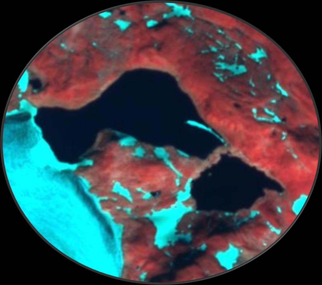
22 14 August September 2018

23 Jøkulhlaup from Blåmannsisen Sentinel-1: GLOF had started early morning 25 August 05:37 Glacier-dammed lake Blåmannsisen

24 Jøkulhlaup from Blåmannsisen Lowering: 32.5 m Volume: ~22 mill. m 3 Glacier-dammed lake Blåmannsisen
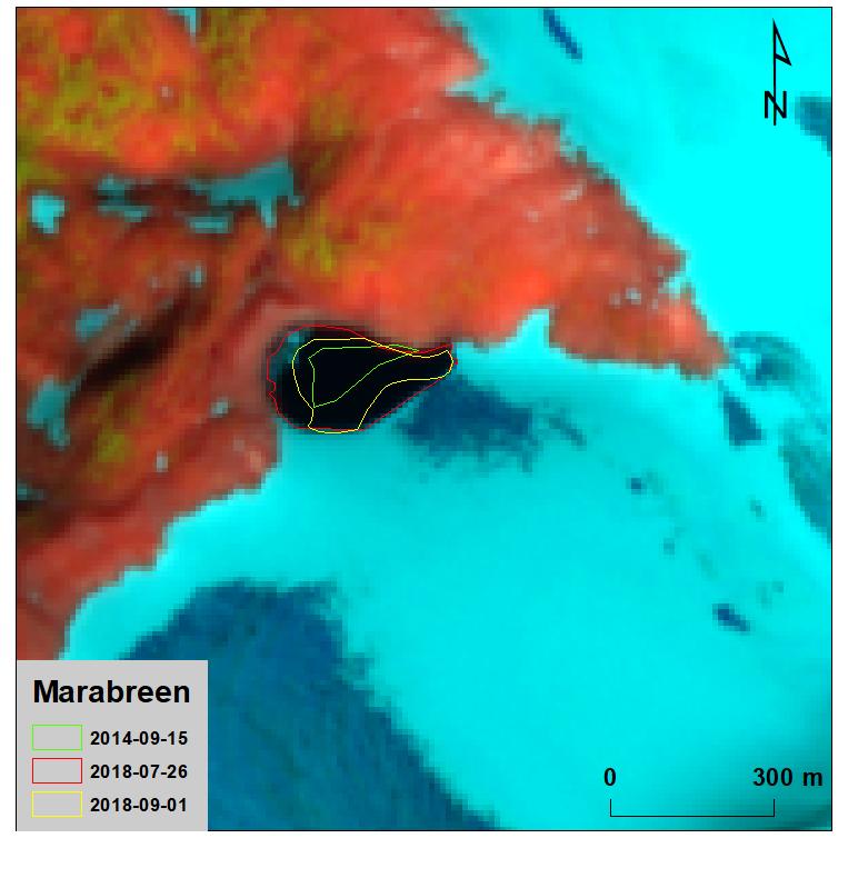

25 /Copernicus Sentinel data 2018/ Example Marabreen 26 July 1 Sep


26 Kronebreen Setevatnet Kongsvegen Uversbreen Setevatnet ~5km Area ~1 km 2

27 Setevatnet Lake Drainage Tile 33XVH Different relative orbits. 23/07/ /07/2017 First image shows the lake at its maximum extent. Drainage was initiated about 12 hours after S-2 acquisition 23/07/2017.
 Need S-2 with Norwegian DEM back to 2015.")
28 Orthorectification & use of DTM Sentinel-2 needs to be processed with good elevation model SK DEM good for glacier mapping S2A available with Norwegian DEM for 2018, but not S2B. (fewer imagery available) Need S-2 with Norwegian DEM back to Sentinel-2 with National SK DEM displacements

29 Conclusions Sentinels suitable glacier mapping & surveying hazards mainland Norway & Svalbard For deriving glacier products: accurate DEM for orthorectification For utilizing full potential: need Sentinel 2B (ASAP)
Observations of glacier dynamics with PALSAR DATA
 Observations of glacier dynamics with PALSAR DATA Tazio Strozzi, Urs Wegmüller and Charles Werner Gamma Remote Sensing, Gümligen, Switzerland Rhodes, Greece, 3 to 7 November 2008 Outline ESA GLOBGLACIER
Part 1 Glaciers on Spitsbergen
 Part 1 Glaciers on Spitsbergen What is a glacier? A glacier consists of ice and snow. It has survived at least 2 melting seasons. It deforms under its own weight, the ice flows! How do glaciers form? Glaciers
Using of space technologies for glacierand snow- related hazards studies
 United Nations / Germany international conference on International Cooperation Towards Low-Emission and Resilient Societies Using of space technologies for glacierand snow- related hazards studies Bonn,
GEOSPATIAL ANALYSIS OF GLACIAL HAZARDS PRONE AREAS OF SHIGAR AND SHAYOK BASINS OF PAKISTAN. By Syed Naseem Abbas Gilany
 GEOSPATIAL ANALYSIS OF GLACIAL HAZARDS PRONE AREAS OF SHIGAR AND SHAYOK BASINS OF PAKISTAN By Syed Naseem Abbas Gilany PRESENTATION OUTLINE Introduction Problem Statement / Rationale Objectives Material
Retreating Glaciers of the Himalayas: A Case Study of Gangotri Glacier Using Satellite Images
 Retreating Glaciers of the Himalayas: A Case Study of Gangotri Glacier Using 1990-2009 Satellite Images Jennifer Ding Texas Academy of Mathematics and Science (TAMS) Mentor: Dr. Pinliang Dong Department
Snow/Ice melt and Glacial Lake Outburst Flood in Himalayan region
 Snow/Ice melt and Glacial Lake Outburst Flood in Himalayan region Dr. SANJAY K JAIN NATIONAL INSTITUTE OF HYDROLOGY ROORKEE Modelling and management flood risk in mountain areas 17-19 Feb., 2015 at Sacramento,
EVALUATION OF DIFFERENT METHODS FOR GLACIER MAPPING USING LANDSAT TM
 EVALUATION OF DIFFERENT METHODS FOR GLACIER MAPPING USING LANDSAT TM Frank Paul Department of Geography, University of Zurich, Switzerland Winterthurer Strasse 190, 8057 Zürich E-mail: fpaul@geo.unizh.ch,
Monitoring of Mountain Glacial Variations in Northern Pakistan, from 1992 to 2008 using Landsat and ALOS Data. R. Jilani, M.Haq, A.
 Monitoring of Mountain Glacial Variations in Northern Pakistan, from 1992 to 2008 using Landsat and ALOS Data R. Jilani, M.Haq, A. Naseer Pakistan Space & Upper Atmosphere Research Commission (SUPARCO)
The 2nd Glacier Inventory of China
 The 2nd Glacier Inventory of China LIU Shiyin Guo Wanqin, Xu Junli, Shangguan Donghui, Wei Junfeng, Wu Lizong, Yu Pengchun, Li Jing, Liu Qiao State Key Laboratory of Cryospheric Sciences, Cold and Arid
Integration Of Reflectance To Study Glacier Surface Using Landsat 7 ETM+: A Case Study Of The Petermann Glacier In Greenland
 Integration Of Reflectance To Study Glacier Surface Using Landsat 7 ETM+: A Case Study Of The Petermann Glacier In Greenland Félix O. Rivera Santiago Department Of Geology, University Of Puerto Rico, Mayaguez
MAURI PELTO, Nichols College, Dudley, MA
 MAURI PELTO, Nichols College, Dudley, MA 01571(mspelto@nichols.edu) Advice I am looking for Better schemes for utilizing atmospheric circulation indices to provide a better forecast for glacier mass balance?
Glacial lakes as sentinels of climate change in Central Himalaya, Nepal
 Glacial lakes as sentinels of climate change in Central Himalaya, Nepal Sudeep Thakuri 1,2,3, Franco Salerno 1,3, Claudio Smiraglia 2,3, Carlo D Agata 2,3, Gaetano Viviano 1,3, Emanuela C. Manfredi 1,3,
The Role of Glaciers in the Hydrologic Regime of the Nepal Himalaya. Donald Alford Richard Armstrong NSIDC Adina Racoviteanu NSIDC
 The Role of Glaciers in the Hydrologic Regime of the Nepal Himalaya Donald Alford Richard Armstrong NSIDC Adina Racoviteanu NSIDC Outline of the talk Study area and data bases Area altitude distributed
SPATIO TEMPORAL CHANGE OF SELECTED GLACIERS ALONG KARAKORAM HIGHWAY FROM USING REMOTE SENSING AND GIS TECHNIQUES
 SPATIO TEMPORAL CHANGE OF SELECTED GLACIERS ALONG KARAKORAM HIGHWAY FROM 1994-217 USING REMOTE SENSING AND GIS TECHNIQUES Yasmeen Anwar 1, Javed Iqbal 2 1 National University of Sciences and Technology
Climate Change Impact on Water Resources of Pakistan
 Pakistan Water and Power Development Authority (WAPDA) Climate Change Impact on Water Resources of Pakistan Glacier Monitoring & Research Centre Muhammad Arshad Pervez Project Director (GMRC) Outline of
SUPPLEMENTARY INFORMATION
 SUPPLEMENTARY INFORMATION DOI: 10.1038/NGEO1450 Slight mass gain of Karakoram glaciers in the early twenty-first century Julie Gardelle 1, Etienne Berthier 2 and Yves Arnaud 3 1 CNRS - Université Grenoble
Snow, Glacier and GLOF
 Snow, Glacier and GLOF & Report on Demonstration River Basin Activities Upper Indus Basin The 5th International Coordination Group (ICG) Meeting GEOSS Asian Water Cycle Initiative (AWCI) Tokyo, Japan,
The dynamic response of Kolohai Glacier to climate change
 Article The dynamic response of Kolohai Glacier to climate change Asifa Rashid 1, M. R. G. Sayyed 2, Fayaz. A. Bhat 3 1 Department of Geology, Savitribai Phule Pune University, Pune 411007, India 2 Department
Platform and Products
 International Partnership Space Programme Earth Observation for the Preservation of Ecological Bacalar Corridor Platform and Products Terri Freemantle, Raffaella Guida, Paula Marti, Pasquale Iervolino
GLOFs from moraine-dammed lakes: their causes and mechanisms V. Vilímek, A. Emmer
 GLOFs from moraine-dammed lakes: their causes and mechanisms V. Vilímek, A. Emmer Department of Physical Geography and Geoecology, Faculty of Science, Charles University, Prague, Czech Republic vilimek@natur.cuni.cz
THE DISEQUILBRIUM OF NORTH CASCADE, WASHINGTON GLACIERS
 THE DISEQUILBRIUM OF NORTH CASCADE, WASHINGTON GLACIERS CIRMOUNT 2006, Mount Hood, OR Mauri S. Pelto, North Cascade Glacier Climate Project, Nichols College Dudley, MA 01571 peltoms@nichols.edu NORTH CASCADE
Glacier Risks. Possibilities and Limits of Prevention and Mitigation. Jörg Hanisch Hannover, Germany John M. Reynolds Mold, UK
 Glacier Risks Possibilities and Limits of Prevention and Mitigation Jörg Hanisch Hannover, Germany John M. Reynolds Mold, UK Glacier Hazards Ice Falls, Surges, and Avalanches Glacier Hazards Glacier Hazards
Glaciers and Glaciation Earth - Chapter 18 Stan Hatfield Southwestern Illinois College
 Glaciers and Glaciation Earth - Chapter 18 Stan Hatfield Southwestern Illinois College Glaciers Glaciers are parts of two basic cycles: 1. Hydrologic cycle 2. Rock cycle A glacier is a thick mass of ice
EO technologies for flood mapping and hydrological modelling in Namibia
 Satellite Earth Observation & Disaster Risks EO technologies for flood mapping and hydrological modelling in Namibia Guido Van Langenhove, Hydrological Services Namibia Hydrological trends in Namibia:
The Potentially Dangerous Glacial Lakes
 Chapter 11 The Potentially Dangerous Glacial Lakes On the basis of actively retreating glaciers and other criteria, the potentially dangerous glacial lakes were identified using the spatial and attribute
OWEA Woolpert UAS Operations
 OWEA 2016 Woolpert UAS Operations UAS Rules and Regulations How Woolpert is Handling This The Exemption In December 2014 Woolpert received approval from the FAA regarding an exemption seeking relief from
Regional impacts and vulnerability mountain areas
 Regional impacts and vulnerability mountain areas 1 st EIONET workshop on climate change vulnerability, impacts and adaptation EEA, Copenhagen, 27-28 Nov 2007 Klaus Radunsky 28 Nov 2007 slide 1 Overview
Adaptation opportunities (and challenges) with glacier melting and Glacier Lake Outburst Floods (GLOFs) in the HKH region
 with glacier melting and Glacier Lake Outburst Floods (GLOFs) in the HKH region") Adaptation opportunities (and challenges) with glacier melting and Glacier Lake Outburst Floods (GLOFs) in the HKH region Jeffrey S. Kargel Department of Hydrology & Water Resources University of Arizona
Adaptation opportunities (and challenges) with glacier melting and Glacier Lake Outburst Floods (GLOFs) in the HKH region Jeffrey S. Kargel Department of Hydrology & Water Resources University of Arizona
NORTH CASCADE SLACIER CLIMATE PROJECT Director: Dr. Mauri S. Pelto Department of Environmental Science Nichols College, Dudley MA 01571
 NORTH CASCADE SLACIER CLIMATE PROJECT Director: Dr. Mauri S. Pelto Department of Environmental Science Nichols College, Dudley MA 01571 INTRODUCTION The North Cascade Glacier-Climate Project was founded
Bachelor Thesis A one-dimensional flowline model applied to Kongsvegen
 Bachelor Thesis A one-dimensional flowline model applied to Kongsvegen J.G.T. Peters Student number: 3484998 Department of Physics and Astronomy, Utrecht University Supervisor: Prof. Dr. J. Oerlemans Coordinator:
DETECTION OF ICE FRONT INITIATION ON THE PEACE RIVER IN NORTHERN ALBERTA Freeze-up
 FINAL REPORT DETECTION OF ICE FRONT INITIATION ON THE PEACE RIVER IN NORTHERN ALBERTA Freeze-up 2013-2014 REFERENCE NO. CO 73797 Presented to: British Columbia Hydro and Power Authority Prepared by: Monique
Glaciers Earth 9th Edition Chapter 18 Mass wasting: summary in haiku form Glaciers Glaciers Glaciers Glaciers Formation of glacial ice
 1 2 3 4 5 6 7 8 9 10 11 12 13 14 15 Earth 9 th Edition Chapter 18 Mass wasting: summary in haiku form Ten thousand years thence big glaciers began to melt - called "global warming." are parts of two basic
Satellite-based measurement of the surface displacement of the largest glacier in Austria
 Conference Volume 4 th Symposium of the Hohe Tauern National Park for Research in Protected Areas September 17 th to 19 th, 2009, Castle of Kaprun pages 145-149 Satellite-based measurement of the surface
A high resolution glacier model with debris effects in Bhutan Himalaya. Orie SASAKI Kanae Laboratory 2018/02/08 (Thu)
") A high resolution glacier model with debris effects in Bhutan Himalaya Orie SASAKI Kanae Laboratory 2018/02/08 (Thu) Research flow Multiple climate data at high elevations Precipitation, air temperature
A high resolution glacier model with debris effects in Bhutan Himalaya Orie SASAKI Kanae Laboratory 2018/02/08 (Thu) Research flow Multiple climate data at high elevations Precipitation, air temperature
Multi-Decadal Changes in Glacial Parameters of the Fedchenko Glacier in Tajikistan
 Cloud Publications International Journal of Advanced Remote Sensing and GIS 2015, Volume 4, Issue 1, pp. 911-919, Article ID Tech-361 ISSN 2320-0243 Research Article Open Access Multi-Decadal Changes in
SCRAMJET. Mapping and monitoring airports with Sentinel 1 and 2 data
 SCRAMJET Mapping and monitoring airports with Sentinel 1 and 2 data 18/03/2018 GISTAM 2018 Urban geospatial mapping for the SCRAMJET business networking tool Nuno Duro, Pedro Coutinho, Gil Gonçalves Index
Caution, glacier terminus ahead: jökulhlaups, surges and large calving events
 Michele Citterio GEUS Glaciology and Climate Dept. Caution, glacier terminus ahead: jökulhlaups, surges and large calving events Geological Survey of Denmark and Greenland photo: John Sylvester ice as
Ground Deformation Monitoring at Natural Gas Production Sites using Interferometric SAR
 Ground Deformation Monitoring at Natural Gas Production Sites using Interferometric SAR By: Kanika Goel, Robert Shau, Fernando Rodriguez Gonzalez, Nico Adam Remote Sensing Technology Institute (IMF), German
Glacial Lake Outburst Flood Mitigation Measures, Monitoring and Early Warning Systems
 Chapter 12 Glacial Lake Outburst Flood Mitigation Measures, Monitoring and Early Warning Systems There are several possible methods for mitigating the impact of Glacial Lake Outburst Flood (GLOF) surges,
A SEGMENTED ARCHITECTURE APPROACH TO PROVIDE A CONTINUOUS, LONG-TERM, ADAPTIVE AND COST- EFFECTIVE GLACIERS MONITORING SYSTEM
 1st IAA Latin American Symposium on Small Satellites: Advanced Technologies and Distributed Systems A SEGMENTED ARCHITECTURE APPROACH TO PROVIDE A CONTINUOUS, LONG-TERM, ADAPTIVE AND COST- EFFECTIVE GLACIERS
Disaster Prevention Monitoring in a Vulnerable Environment Mahabir Pun
 Disaster Prevention Monitoring in a Vulnerable Environment Mahabir Pun Nepal Wireless Project Nepal Research & Education Network 14 April 2008, Japan My Involvement Chairman, the Institute for Himalayan
How Internet can be used for climate change monitoring, early warning and mitigation in the Himalayas? Guarab Raj Upadhaya
 How Internet can be used for climate change monitoring, early warning and mitigation in the Himalayas? Guarab Raj Upadhaya Nepal Wireless Project Nepal Research & Education Network December 4, 2008 My
Lidar Imagery Reveals Maine's Land Surface in Unprecedented Detail
 Maine Geologic Facts and Localities December, 2011 Lidar Imagery Reveals Maine's Land Surface in Unprecedented Detail Text by Woodrow Thompson, Department of Agriculture, Conservation & Forestry 1 Introduction
Compiling a new glacier inventory for southeastern Qinghai Tibet Plateau from Landsat and PALSAR data
 Journal of Glaciology (2016), Page 1 of 14 doi: 10.1017/jog.2016.58 The Author(s) 2016. This is an Open Access article, distributed under the terms of the Creative Commons Attribution licence (http://creativecommons.
Observation of cryosphere
 Observation of cryosphere By Sagar Ratna Bajracharya (email: sagar.bajracharya@icimod.org) Samjwal Ratna Bajracharya Arun Bhakta Shrestha International Centre for Integrated Mountain Development Kathmandu,
THE Greenland Ice Sheet (GrIS) is losing mass due to a
 is losing mass due to a") IEEE GEOSCIENCE AND REMOTE SENSING LETTERS, VOL. 10, NO. 4, JULY 2013 801 Supraglacial Streams on the Greenland Ice Sheet Delineated From Combined Spectral Shape Information in High-Resolution Satellite
IEEE GEOSCIENCE AND REMOTE SENSING LETTERS, VOL. 10, NO. 4, JULY 2013 801 Supraglacial Streams on the Greenland Ice Sheet Delineated From Combined Spectral Shape Information in High-Resolution Satellite
POLAR I.C.E. (Interactive Climate Education)
") POLAR I.C.E. (Interactive Climate Education) 1 WHAT IS HAPPENING TO ANTARCTICA S PINE ISLAND GLACIER? Teacher Supporting Information Use your understanding of glacier science to figure out what is happening
POLAR I.C.E. (Interactive Climate Education) 1 WHAT IS HAPPENING TO ANTARCTICA S PINE ISLAND GLACIER? Teacher Supporting Information Use your understanding of glacier science to figure out what is happening
Himalayan Glaciers Climate Change, Water Resources, and Water Security. Henry Vaux, Committee Chair December 10, 2012
 Himalayan Glaciers Climate Change, Water Resources, and Water Security Henry Vaux, Committee Chair December 10, 2012 Study Context Glacial meltwater is commonly thought h to significantly ifi contribute
glacier Little Ice Age continental glacier valley glacier ice cap glaciation firn glacial ice plastic flow basal slip Chapter 14
 Little Ice Age glacier valley glacier continental glacier ice cap glaciation firn glacial ice plastic flow basal slip glacial budget zone of accumulation zone of wastage glacial surge abrasion glacial
UPDATING THE SURFACE AREA AND VOLUME EQUATIONS OF LAKE NASSER USING MULTIBEAM SYSTEM
 UPDATING THE SURFACE AREA AND VOLUME EQUATIONS OF LAKE NASSER USING MULTIBEAM SYSTEM Nader M. Shafik Researcher, Nile Research Institute, E-mail: shafik_nader@yahoo.com ABSTRACT Lake Nasser is the main
Snow Cover and Glacier Change Study in Nepalese Himalaya Using Remote Sensing and Geographic Information System
 26 A. B. Shrestha & S. P. Joshi August 2009 Snow Cover and Glacier Change Study in Nepalese Himalaya Using Remote Sensing and Geographic Information System Arun Bhakta Shrestha 1 and Sharad Prasad Joshi
Evolution of Ossoue glacier, French Pyrenees: Tools and methods to generate a regional climate-proxy
 Evolution of Ossoue glacier, French Pyrenees: Tools and methods to generate a regional climate-proxy Renaud MARTI ab, Simon GASCOIN a, Thomas HOUET b, Dominique LAFFLY b, Pierre RENE c a CESBIO b GEODE,
ENSC454 Snow and Ice: Glaciers April Roger Wheate (NRES)
") ENSC454 Snow and Ice: Glaciers April 1 2015 Roger Wheate (NRES) Roger.Wheate@unbc.ca Sólheimajökull, Iceland The main purpose of snow: it makes glaciers April 1 other uses of snow April 1 uses of glaciers:
ENSC454 Snow and Ice: Glaciers April 1 2015 Roger Wheate (NRES) Roger.Wheate@unbc.ca Sólheimajökull, Iceland The main purpose of snow: it makes glaciers April 1 other uses of snow April 1 uses of glaciers:
INTERAGENCY AGREEMENT BETWEEN NATIONAL PARK SERVICE and NASA/Goddard Space Flight Center Cryospheric Sciences Branch, Code 614.1
 1 INTERAGENCY AGREEMENT BETWEEN NATIONAL PARK SERVICE and NASA/Goddard Space Flight Center Cryospheric Sciences Branch, Code 614.1 Project Title: Change Analysis of Glacier Ice Extent and Coverage for
SUPPLEMENTARY INFORMATION
 doi:10.1038/nature11324 Here we provide Supplementary Methods and Discussions about - Data preparation - Reasons for data selection - Computing elevation difference trends - Division of the study region
Quantifying Changes in Glacier Thickness and Area Using Remote Sensing and GIS: Taku Glacier System, AK
 Quantifying Changes in Glacier Thickness and Area Using Remote Sensing and GIS: Taku Glacier System, AK by Lara Hughes-Allen A Thesis Presented to the Faculty of the USC Graduate School University of Southern
New issues raised on collision avoidance by the introduction of remotely piloted aircraft (RPA) in the ATM system
 in the ATM system") New issues raised on collision avoidance by the introduction of remotely piloted aircraft (RPA) in the ATM system Jean-Marc Loscos DSNA expert on collision avoidance and airborne surveillance EIWAC 2013
New issues raised on collision avoidance by the introduction of remotely piloted aircraft (RPA) in the ATM system Jean-Marc Loscos DSNA expert on collision avoidance and airborne surveillance EIWAC 2013
COSMO-Coast. L Aquila. La Sapienza. Tor Vergata. Dipartimento di Architettura ed Urbanistica. Dipartimento di Informatica, Sistemi e Produzione,
 COSMO-Coast Tor Vergata Dipartimento di Informatica, Sistemi e Produzione, L Aquila Dipartimento di Architettura ed Urbanistica La Sapienza Dipartimento Ingegneria Civile, Edile ed Ambientale Introduction
UNMANNED AIRCRAFT SYSTEMS (UAS) IN UTILITIES
 IN UTILITIES") UNMANNED AIRCRAFT SYSTEMS (UAS) IN UTILITIES Presented by: Dan Carbone Avion Unmanned Why Drones? Why Drones? Cost Effective Entire cost of a UAS program can be recouped in first-year man-hour savings
UNMANNED AIRCRAFT SYSTEMS (UAS) IN UTILITIES Presented by: Dan Carbone Avion Unmanned Why Drones? Why Drones? Cost Effective Entire cost of a UAS program can be recouped in first-year man-hour savings
We are IntechOpen, the world s leading publisher of Open Access books Built by scientists, for scientists. International authors and editors
 We are IntechOpen, the world s leading publisher of Open Access books Built by scientists, for scientists 3,800 116,000 120M Open access books available International authors and editors Downloads Our
RESEARCH AT HUASCARAN NATIONAL PARK
 FINAL REPORT RESEARCH AT HUASCARAN NATIONAL PARK June 30 July 22, 2012 Prepared By: Daene McKinney, Rachel Chisolm, Marcelo Somos-Valenzuela University of Texas at Austin Alton Byers, Katalyn Voss The
The SHARE contribution to the knowledge of the HKKH glaciers, the largest ice masses of our planet outside the polar regions
 The SHARE contribution to the knowledge of the HKKH glaciers, the largest ice masses of our planet outside the polar regions Claudio Smiraglia 1 with the collaboration of Guglielmina Diolaiuti 1 Christoph
Glaciological investigations in Norway Bjarne Kjøllmoen (Ed.)
") Glaciological investigations in Norway 2016 Bjarne Kjøllmoen (Ed.) 76 2017 R E P O R T Glaciological investigations in Norway 2016 Published by: Editor: Authors: Norwegian Water Resources and Energy Directorate
Glaciological investigations in Norway 2016 Bjarne Kjøllmoen (Ed.) 76 2017 R E P O R T Glaciological investigations in Norway 2016 Published by: Editor: Authors: Norwegian Water Resources and Energy Directorate
Hazard assessment of glacial lake outburst floods from Kyagar glacier, Karakoram mountains, China
 34 Annals of Glaciology (55)66 2014 doi: 10.3189/2014AoG66A001 Hazard assessment of glacial lake outburst floods from Kyagar glacier, Karakoram mountains, China Christoph HAEMMIG, 1 Matthias HUSS, 1,2
WATER, ICE, AND METEOROLOGICAL MEASUREMENTS AT SOUTH CASCADE GLACIER, WASHINGTON, BALANCE YEARS
 WATER, ICE, AND METEOROLOGICAL MEASUREMENTS AT SOUTH CASCADE GLACIER, WASHINGTON, 2-1 BALANCE YEARS U.S. GEOLOGICAL SURVEY Water-Resources Investigations Report 2-4165 South Cascade Glacier, looking approximately
Glacier change, kinematic waves, and outburst floods at. Nisqually Glacier, Mountain Rainier, Washington
 Glacier change, kinematic waves, and outburst floods at Introduction Nisqually Glacier, Mountain Rainier, Washington Data Analysis and Review By Jonathan Skloven Gill and Andrew G. Fountain, Department
Japan Earthquake and Tsunami: a view from satellite data
 Università degli studi di Roma Tor Vergata Corso di Telerilevamento e Cartografia Anno accademico 2012/2013 Japan Earthquake and Tsunami: a view from satellite data Dr. Matteo Picchiani picchiani@disp.uniroma2.it
Unmanned Aerial Vehicles for Environmental Applications
 Unmanned Aerial Vehicles for Environmental Applications John Rankin, President, J.R. Canadian Mapping Ltd. 10 th Annual Professional Biology Conference April 23 rd, 2015 UAVs Our System Suitable Sites
USING ECOGNITION TO AUTOMATICALLY DETECT AND MAP AVALANCHE DEPOSITS FROM THE SPRING 2009 AVALANCHE CYCLE IN THE TATRA MTS.
 USING ECOGNITION TO AUTOMATICALLY DETECT AND MAP AVALANCHE DEPOSITS FROM THE SPRING 2009 AVALANCHE CYCLE IN THE TATRA MTS., SLOVAKIA R. Frauenfelder a, 0F*, M. J. Lato b, M. Biskupič c,d a Norwegian Geotechnical
P. Kasser and H. Siegenthaler, Laboratory of Hydraulics, Hydrology and
 THICKNESS CHANGES OF SWISS GLACIERS (Aerial photogrammetrie maps) Silvretta, Verstancla and Chamm glaciers, surveys 1959 and 1973; 1:10,000 (1976) Limmern and Plattalva glaciers, surveys 1947 and 1977;
Climate Change Impacts on Glacial Lakes and Glacierized Basins in Nepal and Implications for Water Resources
 Climate Change Impacts on Glacial Lakes and Glacierized Basins in Nepal and Implications for Water Resources Suresh R. Chalise 1, Madan Lall Shrestha 2, Om Ratna Bajracharya 2 & Arun Bhakta Shrestha 2
Cal/Val Activities at the CIGSN Uardry Field Site, NSW, Australia in Support of the EO-1 Mission
 Cal/Val Activities at the CIGSN Uardry Field Site, NSW, Australia in Support of the EO-1 Mission Fred Prata and Graham Rutter CSIRO Atmospheric Research David Jupp CSIRO Earth Observation Centre EOC Annual
Glacier change in the American West. The Mazama legacy of f glacier measurements
 Glacier change in the American West 1946 The Mazama legacy of f glacier measurements The relevance of Glaciers Hazards: Debris Flows Outburst Floods Vatnajokull, 1996 White River Glacier, Mt. Hood The
A - GENERAL INFORMATION
 A - GENERAL INFORMATION NOTES ON THE COMPLETION OF THE DATA SHEET This data sheet should be completed in cases of new glacier entries related to available fluctuation data # ; for glaciers already existing
Water Quality Monitoring and Validation from NOAA operational satellite sensor (VIIRS) Data Products in Coral Reef Environments
 Data Products in Coral Reef Environments") Water Quality Monitoring and Validation from NOAA operational satellite sensor (VIIRS) Data Products in Coral Reef Environments William J Hernandez, Ph.D 1, 4 Post-Doctoral Researcher Roy A. Armstrong
Water Quality Monitoring and Validation from NOAA operational satellite sensor (VIIRS) Data Products in Coral Reef Environments William J Hernandez, Ph.D 1, 4 Post-Doctoral Researcher Roy A. Armstrong
Implications of the Ice Melt: A Global Overview
 Implications of the Ice Melt: A Global Overview Hindu Kush Himalayas International Centre for Integrated Mountain Development Kathmandu, Nepal Our Ice Dependent World The 6th Open Assembly of the Northern
Regional implementation of Electronic Terrain and Obstacle data (e-tod) (Presented by Jeppesen)
 (Presented by Jeppesen)") International Civil Aviation Organization SAM/IG/13-WP/39 South American Regional Office 5/04/14 Thirteenth Workshop/Meeting of the SAM Implementation Group English only (SAM/IG/13) - Regional Project
International Civil Aviation Organization SAM/IG/13-WP/39 South American Regional Office 5/04/14 Thirteenth Workshop/Meeting of the SAM Implementation Group English only (SAM/IG/13) - Regional Project
Figure Pre- and post-disaster satellite topographical maps
 2.1.3 Image analysis by JAXA JAXA conducted ongoing emergency observations using Daichi in the wake of the Great East Japan Earthquake, releasing reporting of its analysis of eastern Japan and Hokkaido
Forecasting temperate alpine glacier survival from accumulation zone observations
 The Cryosphere, 4, 67 75, 2010 Author(s) 2010. This work is distributed under the Creative Commons Attribution 3.0 License. The Cryosphere Forecasting temperate alpine glacier survival from accumulation
Investigation on Development of Agricultural Monitoring System Using Satellite Data
 Investigation on Development of Agricultural Monitoring System Using Satellite Data Genya SAITO (1), Daisuke KUNII (1), Naoki ISHITSUKA (2) (1) Tohoku University, 1-1,Tsutsumidori Amamiya-machi Aoba-ku,
Weather-Technology-in-the-Cockpit (WTIC) Program Weather State Change Notification and Use of Portable Weather Application Study
 Program Weather State Change Notification and Use of Portable Weather Application Study") Weather-Technology-in-the-Cockpit (WTIC) Program Weather State Change Notification and Use of Portable Weather Application Study By: Ian Johnson WTIC Engineering Psychologist and Human Factors Lead Date:
Weather-Technology-in-the-Cockpit (WTIC) Program Weather State Change Notification and Use of Portable Weather Application Study By: Ian Johnson WTIC Engineering Psychologist and Human Factors Lead Date:
Surge-type Glaciers. Definition, Characteristics Geographical distribution Why do glaciers surge? Surges and climate change?
 Surge-type Glaciers Definition, Characteristics Geographical distribution Why do glaciers surge? Surges and climate change? Regine Hock International Summer School in Glaciology 2018, McCarthy, Alaska
Impact of Climate Change in the Hindu Kush-Himalayan Region
 Impact of Climate Change in the Hindu Kush-Himalayan Region Basanta Shrestha (bshrestha@icimod.org), Division Head MENRIS, ICIMOD Focus on Glacial Lake Outburst Floods (GLOFs) Sentinel Asia JPTM Step 2
Establishing a Risk-Based Separation Standard for Unmanned Aircraft Self Separation
 Establishing a Risk-Based Separation Standard for Unmanned Aircraft Self Separation Roland E. Weibel, Matthew W.M. Edwards, and Caroline S. Fernandes MIT Lincoln laboratory Surveillance Systems Group Ninth
Seasonal fluctuations in the advance of a tidewater glacier and potential causes: Hubbard Glacier, Alaska, USA
 Journal of Glaciology, Vol. 54, No. 186, 2008 401 Seasonal fluctuations in the advance of a tidewater glacier and potential causes: Hubbard Glacier, Alaska, USA J. Brent RITCHIE, Craig S. LINGLE, Roman
UAS to GIS Utilizing a low-cost Unmanned Aerial System (UAS) for Coastal Erosion Monitoring
 for Coastal Erosion Monitoring") UAS to GIS Utilizing a low-cost Unmanned Aerial System (UAS) for Coastal Erosion Monitoring Agenda Scope of today s presentation Demonstration Objectives Wrightsville Beach Test Area Masonboro Inlet Jetties
UAS to GIS Utilizing a low-cost Unmanned Aerial System (UAS) for Coastal Erosion Monitoring Agenda Scope of today s presentation Demonstration Objectives Wrightsville Beach Test Area Masonboro Inlet Jetties
Glacier variations of Hielo Patagónico Norte, Chile, over 70 years from 1945 to 2015
 Glacier variations of Hielo Patagónico Norte, Chile, over 70 years from 1945 to 2015 Masamu ANIYA 1 Abstract 1. Introduction Background Glacier variations of Hielo Patagónico Norte, Chile, over 70 years
CRYOSPHERE NEPAL. BIKRAM SHRESTHA ZOOWA Sr. Hydrologist Department of Hydrology and Meteorology NEPAL 2016
 CRYOSPHERE NEPAL BIKRAM SHRESTHA ZOOWA Sr. Hydrologist Department of Hydrology and Meteorology NEPAL 2016 ORGANISATIONAL STRUCTURE Ministry of Science, Technology and Environment DEPARTMENT OF HYDROLOGY
HEATHROW COMMUNITY NOISE FORUM
 HEATHROW COMMUNITY NOISE FORUM 3Villages flight path analysis report January 216 1 Contents 1. Executive summary 2. Introduction 3. Evolution of traffic from 25 to 215 4. Easterly departures 5. Westerly
Integrated remote and in situ analysis of a playa lake groundwater system in northern Chile. Katherine H. Markovich The University of Texas at Austin
 Integrated remote and in situ analysis of a playa lake groundwater system in northern Chile Katherine H. Markovich The University of Texas at Austin Hydrogeology of Arid Environments March 15 th, 2012
Impact of Climate Change on Himalayan Glaciers and Glacial Lakes. APN International Symposium 2 December 2007 Kobe, Japan
 Impact of Climate Change on Himalayan Glaciers and Glacial Lakes APN International Symposium 2 December 2007 Kobe, Japan Presented By: Basanta Shrestha, Division Head MENRIS, ICIMOD (bshrestha@icimod.org)
MARINA BOLADO PENAGOS A METHODOLOGY TO ASSESS THE ROLE OF THE RIVER DISCHARGES TO THE GULF OF CADIZ ON THE NUTRIENT SUPPLY TO THE ALBORAN SEA
 MARINA BOLADO PENAGOS A METHODOLOGY TO ASSESS THE ROLE OF THE RIVER DISCHARGES TO THE GULF OF CADIZ ON THE NUTRIENT SUPPLY TO THE ALBORAN SEA INTRODUCTION General MEGAN Project Case Study Guadalquivir
Presentation: UAS Helicopter Waran -1-
 Presentation: UAS Helicopter Waran -1- The unique design features of the Waran provide a superior payload capacity, prolonged endurance, stable flight patterns and a high degree of safety features. Technical
Picture: The glacier Bøverbreen in the mountain area Jotunheimen in the southern part of Norway.
 Picture: The glacier Bøverbreen in the mountain area Jotunheimen in the southern part of Norway. I am honored to be given the opportunity to open this international conference The Frozen Pasts. As a politician
A Statistical Method for Eliminating False Counts Due to Debris, Using Automated Visual Inspection for Probe Marks
 A Statistical Method for Eliminating False Counts Due to Debris, Using Automated Visual Inspection for Probe Marks SWTW 2003 Max Guest & Mike Clay August Technology, Plano, TX Probe Debris & Challenges
Enhancing hydrological data management and exchange procedures
 Enhancing hydrological data management and exchange procedures The Sava River Hydraulic Model Dr Mark R Jourdan, PE Research Hydraulic Engineer U.S. Army Engineer Research and Development Center Vicksburg,
along a transportation corridor in
 Rockfall hazard and risk assessment along a transportation corridor in the Nera Valley, Central Italy Presentation on the paper authored by F. Guzzetti and P. Reichenbach, 2004 Harikrishna Narasimhan Eidgenössische
THE IMPACTS OF CLIMATE CHANGE ON SKI RESORTS AND TOURIST TRAFFIC. M. Tepfenhart, W. Mauser and F. Siebel
 THE IMPACTS OF CLIMATE CHANGE ON SKI RESORTS AND TOURIST TRAFFIC M. Tepfenhart, W. Mauser and F. Siebel Department of Geography, University of Munich, Luisenstr. 37, D - 80333 Munich, Germany, Sebastian
Community resources management implications of HKH hydrological response to climate variability
 Community resources management implications of HKH hydrological response to climate variability -- presented by N. Forsythe on behalf of: H.J. Fowler, C.G. Kilsby, S. Blenkinsop, G.M. O Donnell (Newcastle
Estimation of Glacier Lake Outburst Flood and its Impact on a Hydro Project in Nepal
 Snow and Glacier Hydrology (Proceedings of the Kathmandu Symposium, November 1992). IAHSPubl. no. 218,1993. 331 Estimation of Glacier Lake Outburst Flood and its Impact on a Hydro Project in Nepal G. MEON