Snow/Ice melt and Glacial Lake Outburst Flood in Himalayan region
|
|
|
- Hortense Katrina Hodges
- 6 years ago
- Views:
Transcription


1 Snow/Ice melt and Glacial Lake Outburst Flood in Himalayan region Dr. SANJAY K JAIN NATIONAL INSTITUTE OF HYDROLOGY ROORKEE Modelling and management flood risk in mountain areas Feb., 2015 at Sacramento, California, USA
2 Himalayan Water Resources About 35% of the geographical area of India is covered by mountains and 58% of this is accounted for by the mighty Himalayas in which more than 5000 glaciers covering about km 2 area. There are 22 major river systems with about 1 million km 2 catchment area lying in the Himalayas, with snow and glacier melt runoff of more than 50%. The seasonal snow and glacier melt coming from the Himalayan Rivers is a dependable source of water for irrigation, hydroelectric power and drinking water supply. The hydropower generation contributes about 26% of total installed capacity in India in which Himalayan river systems contribute 78% of the total Indian hydropower potential. Snow melt modelling is a crucial element to predict runoff from snowcovered or glacierised areas, as well as for snow/ice melt flooding The flood due to glacial lake outburst is one of the major issue because of climate change.
3 Western Disturbances Nov. March/April Lesser Himalaya m Outer Himalaya m Siwalik Terai m <300m Greater Himalaya > 4600m 4000m Tibetan Plateau SW Monsoon June Sep Glaciers 10% Winter snow cover % Maximum monsoon precipitation at m asl


4 INDUS, GANGA, BRAHMAPUTRA BASINS 4
5 The situation can become of even greater concern if the rising snowmelt runoff is compounded by runoff from heavy rainfall. SNOW/ICE MELT FLOOD It is known that the effect of global climate change on hydrologic systems, especially on mountain snow and glacier melt, can modify the timing and amount of runoff in mountainous watersheds. Streamflow simulation and forecast is of great importance to water resources management and planning, and can provide a firm basis for forecasts of water resources availability while minimizing the risk and loss from floods caused by rapid snow and glacier melt. When the ground is frozen, the water produced by the melting snow is unable to penetrate and runs off over the ground surface into streams and lakes.
 can occur when a lake contained by a glacier or a terminal moraine dam fails.")
6 Glacial Lake And Glacial Lake Outburst Flood (GLOF) Glacial dammed lakes are formed by accumulation of water from the melting of Snow and Ice cover and by blockage of end moraines. A glacial lake outburst flood (GLOF) can occur when a lake contained by a glacier or a terminal moraine dam fails. The bursting of moraine-dammed lakes is often due to the breaching of the dam by the erosion of the dam material as a result of overtopping by surging water or piping of dam material GLOF STUDIES HAVE BEEN CARRIED OUT FOR LAKES IN THE BASINS OF GHARWAL HIMALAYA, EASTERN HIMALAYA AND BHUTAN HIMALAYS
7 SNOW AND GLACIER MELT

8 STREAM FLOW MODELLING IN SATLUJ BASIN Location of the study area and meteorological stations in the Satluj basin
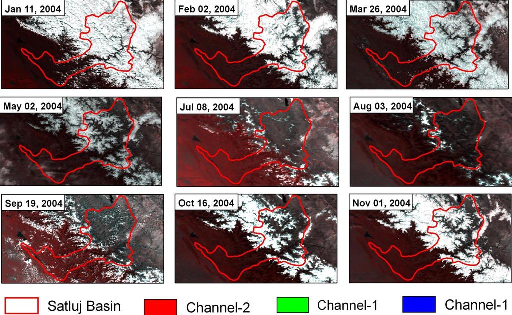

9 NOAA-AVHRR Images (2004)

10 MODIS SNOW Data Product (2004)
")
11 MODIS LST Data Product (2004)
12 Snow Cover Depletion Curve
13 Lapse Rate estimation from MODIS LST maps
14 METHODOLOGY
15 STREAM FLOW MODELLING Main steps in modelling are as follows: Division of Basin Into Elevation Bands Processing of Meteorological Data Temperature Distribution Precipitation Distribution Variability of Snow Covered Area Form of Precipitation Melt due to rain Degree Day Factor for Snow and Ice Routing of Surface and Sub Surface Flow

16 Simulation of Runoff ( )
17 Simulation of Runoff ( )
18 ASSESSMENT AND SIMULATION OF GLACIER LAKE OUTBURST FLOODS IN HIMALAYAN REGION To estimate the flood due to GLOF Valley planning and flood management To formulate emergency procedures such as warning system, evacuation plan etc. To identify and solve unexpected flood problems due to accidents To remove fear in public and make the public aware of the risk To analyze past accidents for advancement of the state of art
19 METHODOLOGY For estimating the Glacial Lake Outburst flood, the following approach and methodology has been adopted: Inventory of glacier and glacial lakes Finding out the potentially dangerous glacial lakes Estimation of Glacial lake volume and finalisation of Glacial lakes for GLOF simulation Estimation of breach parameter for GLOF/dam breach simulation and the consequent dam breach flood using MIKE11 model Channel routing of dam breach flood through the entire reach of river from the GLOF site to the site to get the magnitude of flood peak at site.
20 IDENTIFICATION OF GLACIAL LAKES Normalized Difference Water Index NDWI (GREEN (GREEN NIR ) NIR ) GREEN is a band that encompasses reflected green light and NIR represents reflected near-infrared radiation The selection of these wavelengths was done to : (1) maximize the typical reflectance of water features by using green light wavelengths (2) minimize the low reflectance of NIR by water features; and (3) take advantage of the high reflectance of NIR by terrestrial vegetation and soil features.
21 Yes Yes Yes Yes Yes NDWI<T 1 Slope<10% No Lake R 1 >T 2 No No Lake Glacial Lake R 2 <T 3 No No Lake R1= BGreen/BNIR R2= BNIR/BSWIR Slope<10% No No Lake Glacial Lake Algorithm to automatically classify glacial lakes on IRS Images, using a decision tree. T i represents a threshold, whose value is determined empirically on each scene by visual inspection.
22 CRITERIA FOR IDENTIFICATION OF DANGEROUS LAKE Rise in lake water level In general the lakes which have a volume of more than 0.01 km3 are found to have past events. A lake which has a larger volume than this is deeper, with a deeper part near the dam (lower part of lake) rather than near the glacier tongue, and has rapid increase in lake water volume is an indication that a lake is potentially dangerous. Activity of supraglacial lakes Groups of closely spaced supraglacial lakes of smaller size at glacier tongues merge as time passes and form bigger lakes. These activities of supraglacial lakes are indications that the lakes are becoming potentially dangerous.
23 POSITION OF LAKES The potentially dangerous lakes are generally at the lower part of the ablation area of the glacier near to the end moraine, and the mother glacier should be sufficiently large to create a potentially dangerous lake environment. The valley lakes with an area bigger than 0.1 km2 and a distance less than 0.5 km from the mother glacier of considerable size are considered to be potentially dangerous. DAM CONDITIONS The natural conditions of the moraine damming the lake determine the lake stability. Lake stability will be less if the moraine dam has a combination of the following characteristics: narrower in the crest area no drainage outflow or outlet not well defined steeper slope of the moraine walls ice cored breached and closed in the past and refilled again with water seepage flow at moraine walls
24 CONDITION OF ASSOCIATED MOTHER GLACIER The following general characteristics of associated mother glaciers can create danger to moraine-dammed lakes: hanging glacier in contact with the lake, bigger glacier area, fast retreating, debris cover at glacier tongue area, steep gradient at glacier tongue area, PHYSICAL CONDITIONS OF SURROUNDINGS potential rockfall/slide (mass movements) site around the lake which can fall into the lake suddenly snow avalanches of large size around the lake which can fall into the lake suddenly neo-tectonic and earthquake activities around or near the lake area climatic conditions of successive years being a relatively wet and cold year followed by a hot and wet or hot and arid year
25 GLOF SIMULATION: INPUT REQUIRED Glacier and Glacier lake mapping Drainage network and Length of stream d/s lake DEM of the basin Cross Section at regular interval downstream of lake Area and Volume of the lake Breach width and Depth 100 year return flood if available

26 MIKE11 DAM BREAK MODELLING
27 LAKE DEPTH The empirical relations as available by Huggel et al. (2002) is: The lake volume D = A 0.42 where D is the depth of lake in m and A is the lake area in m 2. LAKE VOLUME The empirical relations as available by Huggel et al. (2002) is: The lake volume V = A 1.42 where V is the lake volume in m 3 and A is the lake area in m 2.
 Chorabari")
28 GLOF: CASE STUDIES Chorabari Lake outburst - (June 17, 2013) Chorabari Lake

29 SNOW COVER DURING MAY-JUNE 2013 Satellite pictures shows that the glacial regions above Kedarnath had received fresh and excess snowfall when heavy rainfall hit the region. (Source NRSC,2013)


30 Elevation in meter GLOF HYDROGRAPH AT CHAMKHARCHU H.E. PROJECT BHUTAN x-section of downstream lake V=54.18 Mm 3 Chubda Lake D=40 m km 900 m 4920 m xsec_dam xsec_5km from dam xsec_10km from dam xsec_15km from dam xsec_20km from dam xsec_25km from dam xsec_30km from dam "xsec_35km from dam xsec_40km from dam xsec_45km from dam xsec_50km from dam xsec_55km from dam xsec_60km from dam xsec_65km from dam xsec_70km from dam xsec_75km from dam xsec_80km from dam xsec_85km from dam xsec_90km from dam xsec_95km from dam xsec_100km from dam xsec_105km from dam xsec_110km from dam xsec_115km from dam Distance from right bank to left bank in meter [m^3/s] Time Series Discharge cumec cumec 2 hour 10 minutes :00: :00:00 08:00:00 12:00:00 16:00:00 20:00:00 00:00: :00:00 08:00:00 12:00:00 16:00:00 20:00:00 00:00:


31 Discharge (m 3 /s) KURI-GONGRI HE PROJECTS, BHUTAN Discharge (m 3 /s) Elevation (m) Kuri basin V=11.62 Mcum 4690 m D=40 m Cross-section of Kuri Basin xsec at dam site xsec at 1 km from dam site xsec at 3 km from dam site xsec at 4 km from dam site xsec at 5 km from dam site xsec at 6 km from dam site xsec at 7 km from dam site xsec at 8 km from dam site xsec at 9 km from dam site xsec at 10 km from dam site xsec at 11 km from dam site xsec at 12 km from dam site xsec at 13 km from dam site xsec at 14 km from dam site xsec at 15 km from dam site xsec at 16 km from dam site xsec at 17 km from dam site xsec at 18 km from dam site xsec at 19 km from dam site 3000 xsec at 20 km from dam site xsec at 21 km from dam site 194 km Distance (m) xsec at 22 km from dam site xsec at 23 km from dam site xsec at 24 km from dam site xsec at 26 km from dam site xsec at 27 km from dam site xsec at 28 km from dam site xsec at 29 km from dam site xsec at 30 km from dam site xsec at 31 km from dam site xsec at 32 km from dam site xsec at 33 km from dam site xsec at 34 km from dam site xsec at 35 km from dam site xsec at 36 km from dam site xsec at 37 km from dam site xsec at 38 km from dam site xsec at 39 km from dam site xsec at 40 km from dam site xsec at 41 km from dam site xsec at 42 km from dam site cumec GLOF KURI GLOF KURI cumec hour 50 minutes :00:00 02:09:36 04:19:12 06:28:48 08:38:24 10:48:00 Time (hh:mm:ss) 0 00:00:00 02:09:36 04:19:12 06:28:48 08:38:24 10:48:00 Time (hh:mm:ss)
 xsec at lake xsec at 1km from")

32 Discharge (m 3 /s) KURI-GONGRI HE PROJECTS, BHUTAN Discharge (m 3 /s) Elevation (m) Gongri basin Mm 3 D=25 m 4564 m km Cross section Of Gongri Basin Distance (m) xsec at lake xsec at 1km from lake xsec at 2km from lake xsec at 3km from lake xsec at 4km from lake xsec at 5km from lake xsec at 6km from lake xsec at 7km from lake xsec at 8km from lake xsec at 9km from lake xsec at 10km from lake xsec at11 km from lake xsec at 12km from lake xsec at 13km from lake xsec at 14km from lake xsec at 15km from lake xsec at 16km from lake xsec at 17km from lake xsec at 18km from lake xsec at 20km from lake xsec at 21km from lake xsec at 22km from lake xsec at 23km from lake xsec at24 km from lake xsec at 25km from lake xsec at 26km from lake xsec at 27km from lake xsec at 28km from lake xsec at 29km from lake xsec at 30km from lake xsec at 31km from lake xsec at 32km from lake xsec at 33km from lake xsec at 34km from lake xsec at 35 km from lake xsec at 36km from lake xsec at37km from lake xsec at 38km from lake xsec at 39km from lake xsec at 40km from lake xsec at 41km from lake xsec at 42km from lake xsec at 43km from lake xsec at44km from lake xsec at 45km from lake xsec at 46km from lake xsec at 47km from lake xsec at 48km from lake xsec at 49km from lake xsec at 50km from lake xsec at 51km from lake xsec at 52km from lake xsec at 53km from lake xsec at 54km from lake xsec at 55km from lake xsec at 56km from lake xsec at 57km from lake xsec at 58km from lake xsec at 59km from lake xsec at 60km from lake xsec at 61km from lake xsec at 62km from lake xsec at 64 km from lake xsec at 66km from lake xsec at 68km from lake xsec at 69km from lake xsec at70 km from lake xsec at 71km from lake xsec at 72km from lake xsec at 74km from lake xsec at 75km from lake xsec at 76km from lake xsec at 77km from lake xsec at 78km from lake xsec at 79km from lake xsec at 80km from lake xsec at 81km from lake xsec at 82km from lake xsec at 83km from lake xsec at 84km from lake cumec GLOF GONGRI GLOF GONGRI cuemc hour 20 minutes :00:00 01:26:24 02:52:48 04:19:12 05:45:36 07:12:00 08:38:24 10:04:48 11:31:12 Time (hh:mm:ss) 0 00:00:00 01:26:24 02:52:48 04:19:12 05:45:36 07:12:00 08:38:24 10:04:48 11:31:12 Time (hh:mm:ss)


33 Q (m 3 /s) Q (m 3 /s) elevation(m) V= Mcum D= 16 m LACHUNG HE PROJECT, SIKKIM, INDIA xsection at lake xsection at 1km from lake xsection at 2 km from lake xsection at 3 km from lake xsection at 4km from lake xsection at 5 km from lake xsection at 6 km from lake xsection at 7km from lake xsection at 8 km from lake xsection at 9 km from lake xsection at 10 km from lake xsection at 11 km from lake xsection at 12 km from lake xsection at 13 km from lake xsection at 14 km from lake xsection at 15 km from lake xsection at 16 km from lake xsection at 17 km from lake xsection at 18 km from lake xsection at 19 km from lake xsection at 20 km from lake xsection at 21 km from lake xsection at 22 km from lake xsection at 23 km from lake xsection at 24 km from lake xsection at 25 km from lake xsection at 26 km from lake xsection at 27 km from lake xsection at 28 km from lake xsection at 29 km from lake xsection at 30 km from lake xsection at 31 km from lake xsection at 32 km from lake xsection at 33 km from lake distance(m) 4812 m Site-I 32 km Site-III 38 km Site-II 36 km cumec cumec cumec cumec Bhimkyong HEP 600 Bop HEP GLOF GLOF minutes 0:00 1:12 2:24 3:36 4:48 6:00 7:12 8:24 9:36 TIME (HH:MM) Site-I :00 1:12 2:24 3:36 4:48 6:00 7:12 8:24 9:36 TIME (HH:MM) Site-II

34 TAWANG H.E. PROJECT, ARUNCHAL PRADESH Elevation(m) V= Mcum V= Mcum D-25 m 4564 m 36 km 1525 m 4348 m 40 km Cross- section of Twang Basin Distance (m) xsec at lake xsec at 1km from lake xsec at 2 km from lake xsec at 3km from lake xsec at 4km from lake xsec at 5km from lake xsec at 6km from lake xsec at 7km from lake xsec at 8km from lake xsec at 9km from lake xsec at 10km from lake xsec at 12km from lake xsec at 13km from lake xsec at 14km from lake xsec at 15km from lake xsec at 16km from lake xsec at 17km from lake xsec at 18km from lake xsec at 19km from lake xsec at 20km from lake xsec at 25km from lake xsec at 26km from lake xsec at 27km from lake xsec at 28km from lake xsec at29 km from lake xsec at 30km from lake xsec at 32km from lake xsec at 33km from lake xsec at 34km from lake xsec at 38km from lake xsec at 39km from lake xsec at 40km from lake xsec at 41km from lake xsec at 42km from lake xsec at 43km from lake xsec at 44km from lake xsec at 45km from lake xsec at 46km from lake xsec at 47km from lake xsec at 48km from lake xsec at 49km from lake xsec at 50km from lake xsec at 51km from lake xsec at 52km from lake xsec at 53km from lake xsec at 54km from lake xsec at 55km from lake xsec at 56km from lake xsec at 57km from lake xsec at 58km from lake cumec cumec cumec cumec 12 minutes 12 minutes

35 Elevation (m) Discharge m3/s Distance from right bank to left bank (m) at 5 Km from Lake at 10 km from lake at 15 Km from lake at 20 Km from Lake at 25 Km from Lake at 30 Km from Lake at 35 Km from Lake at 40 Km from Lake at 45 Km from Lake at 50 Km from Lake at 55 Km from Lake at 60 Km from Lake at 65 Km from Lake at 70 Km from Lake at 75 Km from Lake at 80 Km from Lake at 85 Km from Lake at 90 Km from Lake :57 02:09 03:21 Time (h) Dam breach flood just down stream to lake
36 RECENT GLOF EVENTS - BHUTAN Bhutan S.No. DATE RIVER BASIN LAKE CAUSE OF GLOF Pho Chu Tarina Tso Not known Pho Chu Unnamed Not known Chamkhar Chu Bachamancha Tso Not known 4 7 Oct 94 Pho Chu Luggye Tso Moraine collapse
37 RECENT GLOF EVENTS - NEPAL Bhutan S.No. DATE RIVER BASIN LAKE CAUSE OF GLOF 1 12 Jul 91 Tamakoshi Chubung Moraine collapse 2 3 Sep 98 Dudh Koshi Tam Pokhari Ice avalanche 3 15 Aug 03 Madi River Kabache Lake Moraine collapse 4 8 Aug 04 Madi River Kabache Lake Moraine collapse
38 METHODS FOR MITIGATING THE IMPACT OF GLOF REDUCING THE VOLUME OF LAKE WATER Possible peak surge discharge from a GLOF could be reduced by reducing the volume of water in the lake. In general, any one or combination of the following methods may be applied for reducing the volume of water in the lake: Controlled breaching Controlled breaching can be carried out by blasting, excavation, or even by dropping bombs from an aircraft. Construction of an outlet control structure For more permanent and precise control of lake outflows, rigid structures made out of stone, concrete, or steel can be used. Pumping or siphoning out the water from the lake, and Making a tunnel through the moraine dam Tunneling through moraines or debris barriers, although risky and difficult because of the type of material blocking the lake, has been carried out in several countries.
39 PREVENTATIVE MEASURES AROUND THE LAKE AREA Any existing and potential source of a larger snow and ice avalanche, slide, or rock fall around the lake area, which has a direct impact on the lake and dam has to be studied in detail. Preventative measures have to be taken such as removing masses of loose rocks to ensure there will be no avalanches into the lake. Real-time monitoring, early warning systems and preparedness education are the most beneficial ways to minimize risk. Preparedness hazard mapping, improving communication, education to create awareness
40 Concluding Remarks Glacier and snow-melt have major contribution to the river flows in the region. It is necessary to characterize the glaciers in different climatological regions of the basin The rate, volume and timing of snow melt are likely to change, therefore, impact of climate change on the snowmelt runoff and total streamflow of the large Himalayan rivers should be investigated using GCMs output as input to the calibrated hydrological models. Studies on the trend of changes in snow cover over the Himalayas/basins along with retreat of glaciers need immediate emphasis.
41 Concluding Remarks Climate warming will increase the frequency and risk of GLOFs Regular mapping and monitoring of lakes are needed Potentially dangerous glacial lakes must be provisionally identified and prioritized for further investigation Potentially dangerous lakes must be monitored on a continuous basis High resolution time series satellite image are useful for this purpose Appropriate measures to reduce the potential risks from these lakes
42 THANKS
The Potentially Dangerous Glacial Lakes
 Chapter 11 The Potentially Dangerous Glacial Lakes On the basis of actively retreating glaciers and other criteria, the potentially dangerous glacial lakes were identified using the spatial and attribute
The Potentially Dangerous Glacial Lakes
 Chapter 11 The Potentially Dangerous Glacial Lakes On the basis of actively retreating glaciers and other criteria, the potentially dangerous glacial lakes were identified using the spatial and attribute
Glacial Lake Outburst Flood Mitigation Measures, Monitoring and Early Warning Systems
 Chapter 12 Glacial Lake Outburst Flood Mitigation Measures, Monitoring and Early Warning Systems There are several possible methods for mitigating the impact of Glacial Lake Outburst Flood (GLOF) surges,
Snow, Glacier and GLOF
 Snow, Glacier and GLOF & Report on Demonstration River Basin Activities Upper Indus Basin The 5th International Coordination Group (ICG) Meeting GEOSS Asian Water Cycle Initiative (AWCI) Tokyo, Japan,
Climate Change Impacts on Glacial Lakes and Glacierized Basins in Nepal and Implications for Water Resources
 Climate Change Impacts on Glacial Lakes and Glacierized Basins in Nepal and Implications for Water Resources Suresh R. Chalise 1, Madan Lall Shrestha 2, Om Ratna Bajracharya 2 & Arun Bhakta Shrestha 2
Impacts of climate change and water induced disasters in high altitude on hydropower development in Nepal. Rijan Bhakta Kayastha, D. Sc.
 Impacts of climate change and water induced disasters in high altitude on hydropower development in Nepal Rijan Bhakta Kayastha, D. Sc. Associate Professor and Coordinator Himalayan Cryosphere, Climate
GEOSPATIAL ANALYSIS OF GLACIAL HAZARDS PRONE AREAS OF SHIGAR AND SHAYOK BASINS OF PAKISTAN. By Syed Naseem Abbas Gilany
 GEOSPATIAL ANALYSIS OF GLACIAL HAZARDS PRONE AREAS OF SHIGAR AND SHAYOK BASINS OF PAKISTAN By Syed Naseem Abbas Gilany PRESENTATION OUTLINE Introduction Problem Statement / Rationale Objectives Material
Adaptation in the Everest Region
 Adaptation in the Everest Region Bhawani S. Dongol Program Officer-Freshwater Program WWF- The Global Conservation Organization bhawani.dongol@wwfnepal.org 26 March 2010 Himalayan water towers The Himalayan
Observation of cryosphere
 Observation of cryosphere By Sagar Ratna Bajracharya (email: sagar.bajracharya@icimod.org) Samjwal Ratna Bajracharya Arun Bhakta Shrestha International Centre for Integrated Mountain Development Kathmandu,
The Role of Glaciers in the Hydrologic Regime of the Nepal Himalaya. Donald Alford Richard Armstrong NSIDC Adina Racoviteanu NSIDC
 The Role of Glaciers in the Hydrologic Regime of the Nepal Himalaya Donald Alford Richard Armstrong NSIDC Adina Racoviteanu NSIDC Outline of the talk Study area and data bases Area altitude distributed
The Inventory of Glacial Lakes
 Chapter 8 The Inventory of Glacial Lakes 8.1 BRIEF DESCRIPTION OF GLACIAL LAKE INVENTORY The inventory of glacial lakes has been systematically carried out using topographic maps. As not all the topographic
Impact of Climate Change in the Hindu Kush-Himalayan Region
 Impact of Climate Change in the Hindu Kush-Himalayan Region Basanta Shrestha (bshrestha@icimod.org), Division Head MENRIS, ICIMOD Focus on Glacial Lake Outburst Floods (GLOFs) Sentinel Asia JPTM Step 2
Hydrology Input for West Souris River IWMP
 Hydrology Input for West Souris River IWMP Prepared by: Mark Lee Manitoba Water Stewardship 1 1 1 Overall view of: drainage area watershed characteristics gauging stations meteorological stations Runoff
Himalayan Glaciers Climate Change, Water Resources, and Water Security. Henry Vaux, Committee Chair December 10, 2012
 Himalayan Glaciers Climate Change, Water Resources, and Water Security Henry Vaux, Committee Chair December 10, 2012 Study Context Glacial meltwater is commonly thought h to significantly ifi contribute
Glacial Lake Outbrust
 South Asia Disaster Report 2007 Chapter 5 An Overview Glaciers have perennially been the source of fresh water for more than 1.3 billion of people 1 in the Indian subcontinent. About 15,000 glaciers and
Climate Change Impact on Water Resources of Pakistan
 Pakistan Water and Power Development Authority (WAPDA) Climate Change Impact on Water Resources of Pakistan Glacier Monitoring & Research Centre Muhammad Arshad Pervez Project Director (GMRC) Outline of
Climate Change and State of Himalayan Glaciers: Issues, Challenges and Facts
 Climate Change and State of Himalayan Glaciers: Issues, Challenges and Facts D.P. Dobhal dpdobhal@wihg.res.in Wadia Institute of Himalayan Geology Dehra Dun Major Issues Are the Himalayan glaciers receding
Glaciology. Water. Glacier. Moraine. Types of glacier-dammed lakes. Mechanics of jökulhlaup
 A Jökulhlaup Jökulhlaup. Catastrophic events where large amounts of water are suddenly discharged. Jökulhlaup s are a sudden and rapid draining of a glacier dammed lake or of water impounded within a glacier.
Warming planet, melting glaciers
 Warming planet, melting glaciers Arun B Shrestha abshrestha@icimod.org International Centre for Integrated Mountain Development Kathmandu, Nepal Asia-Pacific Youth forum on Climate Actions and Mountain
Implications of the Ice Melt: A Global Overview
 Implications of the Ice Melt: A Global Overview Hindu Kush Himalayas International Centre for Integrated Mountain Development Kathmandu, Nepal Our Ice Dependent World The 6th Open Assembly of the Northern
Expansion of glacier lakes in recent decades in the Bhutan Himalayas
 Debris-Covered Glaciers (Proceedings of a workshop held at Seattle, Washington, USA, September 2000). IAHS Publ. no. 264, 2000. 165 Expansion of glacier lakes in recent decades in the Bhutan Himalayas
Impact of Climate Change on Himalayan Glaciers and Glacial Lakes. APN International Symposium 2 December 2007 Kobe, Japan
 Impact of Climate Change on Himalayan Glaciers and Glacial Lakes APN International Symposium 2 December 2007 Kobe, Japan Presented By: Basanta Shrestha, Division Head MENRIS, ICIMOD (bshrestha@icimod.org)
Using of space technologies for glacierand snow- related hazards studies
 United Nations / Germany international conference on International Cooperation Towards Low-Emission and Resilient Societies Using of space technologies for glacierand snow- related hazards studies Bonn,
How Glaciers Change the World By ReadWorks
 How Glaciers Change the World How Glaciers Change the World By ReadWorks Glaciers are large masses of ice that can be found in either the oceans or on land. These large bodies of frozen water have big
Monitoring of Mountain Glacial Variations in Northern Pakistan, from 1992 to 2008 using Landsat and ALOS Data. R. Jilani, M.Haq, A.
 Monitoring of Mountain Glacial Variations in Northern Pakistan, from 1992 to 2008 using Landsat and ALOS Data R. Jilani, M.Haq, A. Naseer Pakistan Space & Upper Atmosphere Research Commission (SUPARCO)
Estimation of Glacier Lake Outburst Flood and its Impact on a Hydro Project in Nepal
 Snow and Glacier Hydrology (Proceedings of the Kathmandu Symposium, November 1992). IAHSPubl. no. 218,1993. 331 Estimation of Glacier Lake Outburst Flood and its Impact on a Hydro Project in Nepal G. MEON
Community resources management implications of HKH hydrological response to climate variability
 Community resources management implications of HKH hydrological response to climate variability -- presented by N. Forsythe on behalf of: H.J. Fowler, C.G. Kilsby, S. Blenkinsop, G.M. O Donnell (Newcastle
Glaciers, Glacial Lakes and GLOF
 Glaciers, Glacial Lakes and GLOF N Samjwal Ratna Bajracharya International Centre for Integrated Mountain Development Kathmandu, Nepal Inventory of Glaciers, Glacial Lakes and GLOF in the Himalaya Afghanistan
Adaptation opportunities (and challenges) with glacier melting and Glacier Lake Outburst Floods (GLOFs) in the HKH region
 with glacier melting and Glacier Lake Outburst Floods (GLOFs) in the HKH region") Adaptation opportunities (and challenges) with glacier melting and Glacier Lake Outburst Floods (GLOFs) in the HKH region Jeffrey S. Kargel Department of Hydrology & Water Resources University of Arizona
Adaptation opportunities (and challenges) with glacier melting and Glacier Lake Outburst Floods (GLOFs) in the HKH region Jeffrey S. Kargel Department of Hydrology & Water Resources University of Arizona
GLOFs from moraine-dammed lakes: their causes and mechanisms V. Vilímek, A. Emmer
 GLOFs from moraine-dammed lakes: their causes and mechanisms V. Vilímek, A. Emmer Department of Physical Geography and Geoecology, Faculty of Science, Charles University, Prague, Czech Republic vilimek@natur.cuni.cz
Lake Chelan Operations
 Lake Chelan Operations IPMA Executive Seminar September 17, 2013 Presented by: Janet Jaspers Chelan County PUD Lake Chelan Hydroelectric Project Today s Discussion Chelan PUD Overview Interesting Facts
Glacial lakes as sentinels of climate change in Central Himalaya, Nepal
 Glacial lakes as sentinels of climate change in Central Himalaya, Nepal Sudeep Thakuri 1,2,3, Franco Salerno 1,3, Claudio Smiraglia 2,3, Carlo D Agata 2,3, Gaetano Viviano 1,3, Emanuela C. Manfredi 1,3,
New measurements techniques
 2 nd Asia CryoNetWorkshop New measurements techniques Xiao Cunde (SKLCS/CAS and CAMS/CMA) Feb.5, 2016, Salekhard, Russia Outline Definition of New Some relative newly-used techniques in China -- Eddy covariance
Glacier Risks. Possibilities and Limits of Prevention and Mitigation. Jörg Hanisch Hannover, Germany John M. Reynolds Mold, UK
 Glacier Risks Possibilities and Limits of Prevention and Mitigation Jörg Hanisch Hannover, Germany John M. Reynolds Mold, UK Glacier Hazards Ice Falls, Surges, and Avalanches Glacier Hazards Glacier Hazards
Present health and dynamics of glaciers in the Himalayas and Arctic
 Present health and dynamics of glaciers in the Himalayas and Arctic AL. Ramanathan and Glacilogy Team School of Environmental Sciences, Jawaharlal Nehru University AL. Ramanthan, Parmanand Sharma, Arindan
HYDROLOGY OF GLACIAL LAKES, FORT SISSETON AREA
 PROC. S.D. ACAD. SCI., VOL. 77 (1998) 59 HYDROLOGY OF GLACIAL LAKES, FORT SISSETON AREA Perry H. Rahn Department of Geology & Geological Engineering South Dakota School of Mines and Technology Rapid City,
Revised Draft: May 8, 2000
 Revised Draft: May 8, 2000 Accepted for publication by the International Association of Hydrological Sciences. Paper will be presented at the Debris-Covered Glaciers Workshop in September 2000 at the University
Draining Himalayan glacial lakes before they burst
 Destructive V/ater: Water-Caused Natural Disasters, their Abatement and Control (Proceedings of the Conference held at Anaheim, California, June 1996). IAHS Publ. no. 239, 1997. 337 Draining Himalayan
A high resolution glacier model with debris effects in Bhutan Himalaya. Orie SASAKI Kanae Laboratory 2018/02/08 (Thu)
") A high resolution glacier model with debris effects in Bhutan Himalaya Orie SASAKI Kanae Laboratory 2018/02/08 (Thu) Research flow Multiple climate data at high elevations Precipitation, air temperature
A high resolution glacier model with debris effects in Bhutan Himalaya Orie SASAKI Kanae Laboratory 2018/02/08 (Thu) Research flow Multiple climate data at high elevations Precipitation, air temperature
Glacier Lakes and Outburst Floods In the Nepal Himalaya
 Snow and Glacier Hydrology (Proceedings of the Kathmandu Symposium, November 1992). IAHSPubl. no. 218,1993. 319 Glacier Lakes and Outburst Floods In the Nepal Himalaya T. YAMABA 1 & C. K. SHARMA 2 1 The
Glaciers. Reading Practice
 Reading Practice A Glaciers Besides the earth s oceans, glacier ice is the largest source of water on earth. A glacier is a massive stream or sheet of ice that moves underneath itself under the influence
Retreating Glaciers of the Himalayas: A Case Study of Gangotri Glacier Using Satellite Images
 Retreating Glaciers of the Himalayas: A Case Study of Gangotri Glacier Using 1990-2009 Satellite Images Jennifer Ding Texas Academy of Mathematics and Science (TAMS) Mentor: Dr. Pinliang Dong Department
GLACIER STUDIES OF THE McCALL GLACIER, ALASKA
 GLACIER STUDIES OF THE McCALL GLACIER, ALASKA T John E. Sater* HE McCall Glacier is a long thin body of ice shaped roughly like a crescent. Its overall length is approximately 8 km. and its average width
Glacial Lake Outburst Floods and Damage in the Country
 9.1 INTRODUCTION Chapter 9 Glacial Lake Outburst Floods and Damage in the Country Periodic or occasional release of large amounts of stored water in a catastrophic outburst flood is widely referred to
Glaciers as Source of Water: The Himalaya
 Sustainable Humanity, Sustainable Nature: Our Responsibility Pontifical Academy of Sciences, Extra Series 41, Vatican City 2014 Pontifical Academy of Social Sciences, Acta 19, Vatican City 2014 www.pas.va/content/dam/accademia/pdf/es41/es41-kulkarni.pdf
Glaciers and Glacial Lakes under Changing Climate in Pakistan
 Pakistan Journal of Meteorology Vol. 8, Issue 15 Glaciers and Glacial Lakes under Changing Climate in Pakistan Rasul, G. 1, Q. Z. Chaudhry 2, A. Mahmood 2, K. W. Hyder 2,3, Qin Dahe 3 Abstract The Himalayas,
Managing Disasters, Sustaining Development in the Hindu Kush Himalayas
 Managing Disasters, Sustaining Development in the Hindu Kush Himalayas Aditi Mukherji Theme Leader, Water and Air ICIMOD amukherji@icimod.org International Centre for Integrated Mountain Development Kathmandu,
NORTH CASCADE SLACIER CLIMATE PROJECT Director: Dr. Mauri S. Pelto Department of Environmental Science Nichols College, Dudley MA 01571
 NORTH CASCADE SLACIER CLIMATE PROJECT Director: Dr. Mauri S. Pelto Department of Environmental Science Nichols College, Dudley MA 01571 INTRODUCTION The North Cascade Glacier-Climate Project was founded
Jeneberang River. Serial No. : Indonesia-10 Location: South Sulawesi Area: 727 km 2 Origin: Mt. Bawakaraeng (2,833 MSL) Outlet: Makassar Strait
 Outlet: Makassar Strait") Jeneberang River Map of River Table of Basic Data Name: Jeneberang River Serial No. : Indonesia-10 Location: South Sulawesi S 5 10' 00" - 5 26' 00" E 119 23' 50" - 119 56' 10" Area: 727 km 2 Origin: Mt.
Jeneberang River Map of River Table of Basic Data Name: Jeneberang River Serial No. : Indonesia-10 Location: South Sulawesi S 5 10' 00" - 5 26' 00" E 119 23' 50" - 119 56' 10" Area: 727 km 2 Origin: Mt.
Status of the Glacier Research in the HKH region. By Dr. S. I. Hasnain School of Environmental Sciences Jawahar Lal Nehru University INDIA
 Status of the Glacier Research in the HKH region By Dr. S. I. Hasnain School of Environmental Sciences Jawahar Lal Nehru University INDIA The climate of Himalaya is essentially dominated by the south-west
Presentation By. My duties and responsibilities in my country Collection and compilation of disaster related data from different Parts of the kingdom.
 Presentation By POKHAREL Lekh Nath Ministry of Home Affairs,His Majesty's Government of Nepal. Disaster Relief Section Kathmandu NEPAL Now as a visiting Researcher at ADRC. My duties and responsibilities
Long term mass and energy balance monitoring of Nepalese glaciers (GLACIOCLIM project): Mera and Changri Nup glaciers
: Mera and Changri Nup glaciers") Long term mass and energy balance monitoring of Nepalese glaciers (GLACIOCLIM project): Mera and Changri Nup glaciers ICIMOD IRD collaboration Cryosphere team Who? o o o o The cryosphere team of ICIMOD,
Long term mass and energy balance monitoring of Nepalese glaciers (GLACIOCLIM project): Mera and Changri Nup glaciers ICIMOD IRD collaboration Cryosphere team Who? o o o o The cryosphere team of ICIMOD,
Climate Change Impacts on Water Resources of Nepal with Reference to the Glaciers in the Langtang Himalayas
 58 N. P. Chaulagain August 2009 Climate Change Impacts on Water Resources of Nepal with Reference to the Glaciers in the Langtang Himalayas Narayan Prasad Chaulagain Alternative Energy Promotion Centre,
RESEARCH AT HUASCARAN NATIONAL PARK
 FINAL REPORT RESEARCH AT HUASCARAN NATIONAL PARK June 30 July 22, 2012 Prepared By: Daene McKinney, Rachel Chisolm, Marcelo Somos-Valenzuela University of Texas at Austin Alton Byers, Katalyn Voss The
Hydrological study for the operation of Aposelemis reservoir Extended abstract
 Hydrological study for the operation of Aposelemis Extended abstract Scope and contents of the study The scope of the study was the analytic and systematic approach of the Aposelemis operation, based on
Disaster Prevention Monitoring in a Vulnerable Environment Mahabir Pun
 Disaster Prevention Monitoring in a Vulnerable Environment Mahabir Pun Nepal Wireless Project Nepal Research & Education Network 14 April 2008, Japan My Involvement Chairman, the Institute for Himalayan
READING QUESTIONS: Glaciers GEOL /WI 60 pts. a. Alpine Ice from larger ice masses flowing through a valley to the ocean
 READING QUESTIONS: Glaciers GEOL 131 18/WI 60 pts NAME DUE: Tuesday, March 13 Glaciers: A Part of Two Basic Cycles (p. 192-195) 1. Match each type of glacier to its description: (2 pts) a. Alpine Ice from
Inventory of Glacial Lakes in the Koshi, Gandaki and Karnali River basins of Nepal and Tibet, China
 Inventory of Glacial Lakes in the Koshi, Gandaki and Karnali River basins of Nepal and Tibet, China Identification of potentially dangerous glacial lakes and prioritization for GLOF risk reduction Submitted
CRYOSPHERE NEPAL. BIKRAM SHRESTHA ZOOWA Sr. Hydrologist Department of Hydrology and Meteorology NEPAL 2016
 CRYOSPHERE NEPAL BIKRAM SHRESTHA ZOOWA Sr. Hydrologist Department of Hydrology and Meteorology NEPAL 2016 ORGANISATIONAL STRUCTURE Ministry of Science, Technology and Environment DEPARTMENT OF HYDROLOGY
Chapter 7 Snow and ice
 Chapter 7 Snow and ice Throughout the solar system there are different types of large ice bodies, not only water ice but also ice made up of ammonia, carbon dioxide and other substances that are gases
The SHARE contribution to the knowledge of the HKKH glaciers, the largest ice masses of our planet outside the polar regions
 The SHARE contribution to the knowledge of the HKKH glaciers, the largest ice masses of our planet outside the polar regions Claudio Smiraglia 1 with the collaboration of Guglielmina Diolaiuti 1 Christoph
Habitat of Large Glaciers and Snow Leopards
 Headwaters of High Mountain Asia - Habitat of Large Glaciers and Snow Leopards International Snow Leopard Day A Collaborative Effort to Assess the Role of Glaciers and Seasonal Snow Cover in the Hydrology
Kurobegawa No.4 Power Plant Toyama Prefecture, Japan (Asia)
") IEA Hydropower Implementing Agreement Annex VIII - Hydropower Good Practices: Environmental Mitigation Measures and Benefits Case Study 14-02: Development of Regional Industries Kurobegawa No.4 Power Plant,
IEA Hydropower Implementing Agreement Annex VIII - Hydropower Good Practices: Environmental Mitigation Measures and Benefits Case Study 14-02: Development of Regional Industries Kurobegawa No.4 Power Plant,
Cau River. Map of River. Table of Basic Data. Vietnam 5
 Cau River Map of River Table of Basic Data Name: Cau River Location: Thai Nguyen, Province, Viet Nam Area: 6,030 km 2 Origin: Mt. Phia Deng 1,527 m Outlet: Pha Lai Note: * Indicates missing data in some
HYDRAULIC DESIGN OF THE TOURISTIC BERTHING IN ASWAN CITY
 HYDRAULIC DESIGN OF THE TOURISTIC BERTHING IN ASWAN CITY Dr. Hossam El-Sersawy Researcher, Nile Research Institute (NRI), National Water Research Center (NWRC), Egypt E-mail: h_sersawy@hotmail.com Dr.
Settlements around Indus Threatened With rise in temperatures, glaciers receding, increase in rainfall and tributaries changing course settlements
 INTRODUCTION Over the centuries the Indus has been the life line for several civilizations. In Ladakh most of the villages have come up on the north bank along the tributaries that are fed by the glacial
Rapid decrease of mass balance observed in the Xiao (Lesser) Dongkemadi Glacier, in the central Tibetan Plateau
 Dongkemadi Glacier, in the central Tibetan Plateau") HYDROLOGICAL PROCESSES Hydrol. Process. 22, 2953 2958 (2008) Published online 8 October 2007 in Wiley InterScience (www.interscience.wiley.com).6865 Rapid decrease of mass balance observed in the Xiao
HYDROLOGICAL PROCESSES Hydrol. Process. 22, 2953 2958 (2008) Published online 8 October 2007 in Wiley InterScience (www.interscience.wiley.com).6865 Rapid decrease of mass balance observed in the Xiao
Regional impacts and vulnerability mountain areas
 Regional impacts and vulnerability mountain areas 1 st EIONET workshop on climate change vulnerability, impacts and adaptation EEA, Copenhagen, 27-28 Nov 2007 Klaus Radunsky 28 Nov 2007 slide 1 Overview
How to develop resilient infrastructure (Global SDG9)
") How to develop resilient infrastructure (Global SDG9) 16-17 November 2017, Ljubljana, Slovenia Development of resilient rail infrastructure, practices in the Republic of Macedonia Darko Miceski Viktorija
How to develop resilient infrastructure (Global SDG9) 16-17 November 2017, Ljubljana, Slovenia Development of resilient rail infrastructure, practices in the Republic of Macedonia Darko Miceski Viktorija
AVALANCHE SAFETY PLAN
 AVALANCHE SAFETY PLAN MUNICIPALITY OF VALTOURNENCHE Valtournenche is a town located at the foot of the Mount Cervin, whose beauty attracts a large number of tourists. The morphology of the territory, characterized
How Internet can be used for climate change monitoring, early warning and mitigation in the Himalayas? Guarab Raj Upadhaya
 How Internet can be used for climate change monitoring, early warning and mitigation in the Himalayas? Guarab Raj Upadhaya Nepal Wireless Project Nepal Research & Education Network December 4, 2008 My
Public Works Research Institute
 Public Works Research Institute INTERNATIONAL WORKSHOP ON WATER HAZARD AND RISK MANAGEMENT SOME EXPERIENCES OF FLOOD MANAGEMENT IN ARGENTINA VÍCTOR POCHAT National Director for Water Policies,Coordination
Recent Changes in Glacier Tongues in the Langtang Khola Basin, Nepal, Determined by Terrestrial Photogrammetry
 Snow and Glacier Hydrology (Proceedings of the Kathmandu Symposium, November 1992). IAHSPubl. no. 218,1993. 95 Recent Changes in Glacier Tongues in the Langtang Khola Basin, Nepal, Determined by Terrestrial
Shrubs and alpine meadows represent the only vegetation cover.
 Saldur river General description The study area is the upper Saldur basin (Eastern Italian Alps), whose elevations range from 2150 m a.s.l. (location of the main monitoring site, LSG) and 3738 m a.s.l.
GRANDE News Letter Volume1, No.3, December 2012
 GRANDE News Letter Volume1, No.3, December 2012 Building a water management system in La Paz, Bolivia Climate change is a phenomenon that affects the entire world, but its impact on people differs depending
IMPACTS OF CLIMATE CHANGE: GLACIAL LAKE OUTBURST FLOODS (GLOFS)
") IMPACTS OF CLIMATE CHANGE: GLACIAL LAKE OUTBURST FLOODS (GLOFS) Binay Kumar and T.S. Murugesh Prabhu ABSTRACT Worldwide receding of mountain glaciers is one of the most reliable evidences of the changing
IMPACTS OF CLIMATE CHANGE: GLACIAL LAKE OUTBURST FLOODS (GLOFS) Binay Kumar and T.S. Murugesh Prabhu ABSTRACT Worldwide receding of mountain glaciers is one of the most reliable evidences of the changing
Annual Report to the. International Joint Commission. from the. International Osoyoos Lake Board of Control for
 Annual Report to the International Joint Commission from the International Osoyoos Lake Board of Control for Calendar Year 2005 INTERNATIONAL JOINT COMMISSION International Osoyoos Lake Board of Control
Waukegan & Calumet Rivers. All Hands Meeting
 Waukegan & Calumet Rivers 516(e) Update All Hands Meeting David F. Bucaro, P.E. Chief, Economic Formulation & Analysis Section, Planning Branch May 18 th, 2011 Kensington Court Ann Arbor, MI 1 2 Waukegan
Typical avalanche problems
 Typical avalanche problems The European Avalanche Warning Services (EAWS) describes five typical avalanche problems or situations as they occur in avalanche terrain. The Utah Avalanche Center (UAC) has
Glaciers. Clicker Question. Glaciers and Glaciation. How familiar are you with glaciers? West Greenland. Types of Glaciers.
 Chapter 21 Glaciers A glacier is a large, permanent (nonseasonal) mass of ice that is formed on land and moves under the force of gravity. Glaciers may form anywhere that snow accumulation exceeds seasonal
II. THE BOULDER CREEK DRAINAGE BASIN
 II. THE BOULDER CREEK DRAINAGE BASIN This section provides an overview of the watersheds and flood hazards associated with Boulder Creek and South Boulder Creek including descriptions of the drainage basins,
READING QUESTIONS: Chapter 7, Glaciers GEOL 131 Fall pts. a. Alpine Ice from larger ice masses flowing through a valley to the ocean
 READING QUESTIONS: Chapter 7, Glaciers GEOL 131 Fall 2018 63 pts NAME DUE: Tuesday, October 23 Glaciers: A Part of Two Basic Cycles (p. 192-195) 1. Match each type of glacier to its description: (2 pts)
THE DISEQUILBRIUM OF NORTH CASCADE, WASHINGTON GLACIERS
 THE DISEQUILBRIUM OF NORTH CASCADE, WASHINGTON GLACIERS CIRMOUNT 2006, Mount Hood, OR Mauri S. Pelto, North Cascade Glacier Climate Project, Nichols College Dudley, MA 01571 peltoms@nichols.edu NORTH CASCADE
MAURI PELTO, Nichols College, Dudley, MA
 MAURI PELTO, Nichols College, Dudley, MA 01571(mspelto@nichols.edu) Advice I am looking for Better schemes for utilizing atmospheric circulation indices to provide a better forecast for glacier mass balance?
Glacial lake outburst flood hazards in Hindukush, Karakoram and Himalayan Ranges of Pakistan: implications and risk analysis
 Geomatics, Natural Hazards and Risk ISSN: 1947-5705 (Print) 1947-5713 (Online) Journal homepage: http://www.tandfonline.com/loi/tgnh20 Glacial lake outburst flood hazards in Hindukush, Karakoram and Himalayan
Nepal Hirnalaya and Tibetan Plateau: a case study of air
 Annals of Glaciology 16 1992 International Glaciological Society Predictions of changes of glacier Inass balance in the Nepal Hirnalaya and Tibetan Plateau: a case study of air teinperature increase for
APPENDIX D: SUSTAINABLE TRAIL DESIGN. APPENDICES Town of Chili Parks and Recreation Master Plan Update
 APPENDIX D: SUSTAINABLE TRAIL DESIGN APPENDICES Town of Chili Parks and Recreation Master Plan Update Sustainable Trail Construction Sustainable trails are defined by the US Forest Service as trails having
Thailand 12. Pasak River. Map of River
 Pasak River Map of River 232 Table of Basic Data Name: Pasak river Serial No. : Thailand-12 Location: Central part of Thailand N 14 21' 44" ~ 17 06' 02" E 100 34' 40" ~ 101 32' 56" Area: 15,779 km 2 Length
Hydraulic Report. Trail 5 Snowmobile Trail Over Mulligan Creek. Prepared By: COLEMAN ENGINEERING COMPANY Karisa V. Falls, P.E.
 Prepared for: Prepared by: Marquette County Road Commission Coleman Engineering Company Marquette, Michigan Iron Mountain, MI December 2011 Hydraulic Report Trail 5 Snowmobile Trail Over Mulligan Creek
Tidewater Glaciers: McCarthy 2018 Notes
 Tidewater Glaciers: McCarthy 2018 Notes Martin Truffer, University of Alaska Fairbanks June 1, 2018 What makes water terminating glaciers special? In a normal glacier surface mass balance is always close
II. Objectives of the study:
 TERMS OF REFERENCE FOR ASCESSING VULNERABILITY OF SAGARMATHA NATIONAL PARK AND BUFFER ZONE AND FORMULATION OF THE COMMUNITY BASED ADAPTATION STRATEGIES I. Background: The Himalayan region having glacier
Introduction to Safety on Glaciers in Svalbard
 Introduction to Safety on Glaciers in Svalbard Content Basic info on Svalbard glaciers Risk aspects when travelling on glaciers Safe travel on glaciers UNIS safety & rescue equipment Companion rescue in
VOLUME CHANGES OF THE GLACIERS IN SCANDINAVIA AND ICELAND IN THE 21st CENTURY
 VOLUME CHANGES OF THE GLACIERS IN SCANDINAVIA AND ICELAND IN THE 21st CENTURY Valentina Radić 1,3 and Regine Hock 2,3 1 Depart. of Earth & Ocean Sciences, University of British Columbia, Vancouver, Canada
1.4 Understand how moving ice acts as an agent of erosion and deposition. (Chap. 2)
") 1.4 Understand how moving ice acts as an agent of erosion and deposition. (Chap. 2) There are two types of glaciation. Alpine Glaciation Continental Glaciation Distinguish between the terms alpine glaciation
1.4 Understand how moving ice acts as an agent of erosion and deposition. (Chap. 2) There are two types of glaciation. Alpine Glaciation Continental Glaciation Distinguish between the terms alpine glaciation
"Transboundary coordination according to the FD Directive in the shared river basins of Greece
 Workshop on Transboundary Issues Budapest March 31st April 1st "Transboundary coordination according to the FD Directive in the shared river basins of Greece Katerina Triantafyllou, ECOS Consulting S.A.
Actual Climatic Conditions in ERB. Online Resource 1 corresponding to:
 Actual Climatic Conditions in ERB. Online Resource 1 corresponding to: Article Title: Climatic Trends and Impact of Climate Change on Agriculture in an Arid Andean Valley. Journal Name: CLIMATIC CHANGE
Environmental Impact Assessment in Chile, its application in the case of glaciers. Carlos Salazar Hydro21 Consultores Ltda.
 Environmental Impact Assessment in Chile, its application in the case of glaciers Carlos Salazar Hydro21 Consultores Ltda. carlos.salazar@hydro21.cl Introduction Changes in the environmental law in Chile
2. (1pt) From an aircraft, how can you tell the difference between a snowfield and a snow-covered glacier?
 From an aircraft, how can you tell the difference between a snowfield and a snow-covered glacier?") 1 GLACIERS 1. (2pts) Define a glacier: 2. (1pt) From an aircraft, how can you tell the difference between a snowfield and a snow-covered glacier? 3. (2pts) What is the relative size of Antarctica, Greenland,
1 GLACIERS 1. (2pts) Define a glacier: 2. (1pt) From an aircraft, how can you tell the difference between a snowfield and a snow-covered glacier? 3. (2pts) What is the relative size of Antarctica, Greenland,
IDENTIFICATION OF GLACIAL FLOOD HAZARDS IN KARAKORAM RANGE USING REMOTE SENSING TECHNIQUE AND RISK ANALYSIS
 IDENTIFICATION OF GLACIAL FLOOD HAZARDS IN KARAKORAM RANGE USING REMOTE SENSING TECHNIQUE AND RISK ANALYSIS Arshad Ashraf*, Rakhshan Roohi*, Rozina Naz* and Naveed Mustafa* ABSTRACT Glacial Lake Outburst
LESOTHO HIGHLANDS DEVELOPMENT AUTHORITY
 LESOTHO HIGHLANDS DEVELOPMENT AUTHORITY ANNUAL FLOW RELEASES INSTREAM FLOW REQUIREMENT (IFR) IMPLEMENTATION AND MONITORING (October 2005 to September 2006) REPORT N0.7 OCTOBER 2007 STRATEGIC AND CORPORATE