Glacier variations of Hielo Patagónico Norte, Chile, over 70 years from 1945 to 2015
|
|
|
- Roger Craig
- 6 years ago
- Views:
Transcription
1 Glacier variations of Hielo Patagónico Norte, Chile, over 70 years from 1945 to 2015 Masamu ANIYA 1 Abstract 1. Introduction Background
 are recognized at Gl. Soler (Aniya, 1985).")
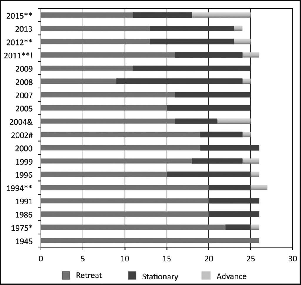
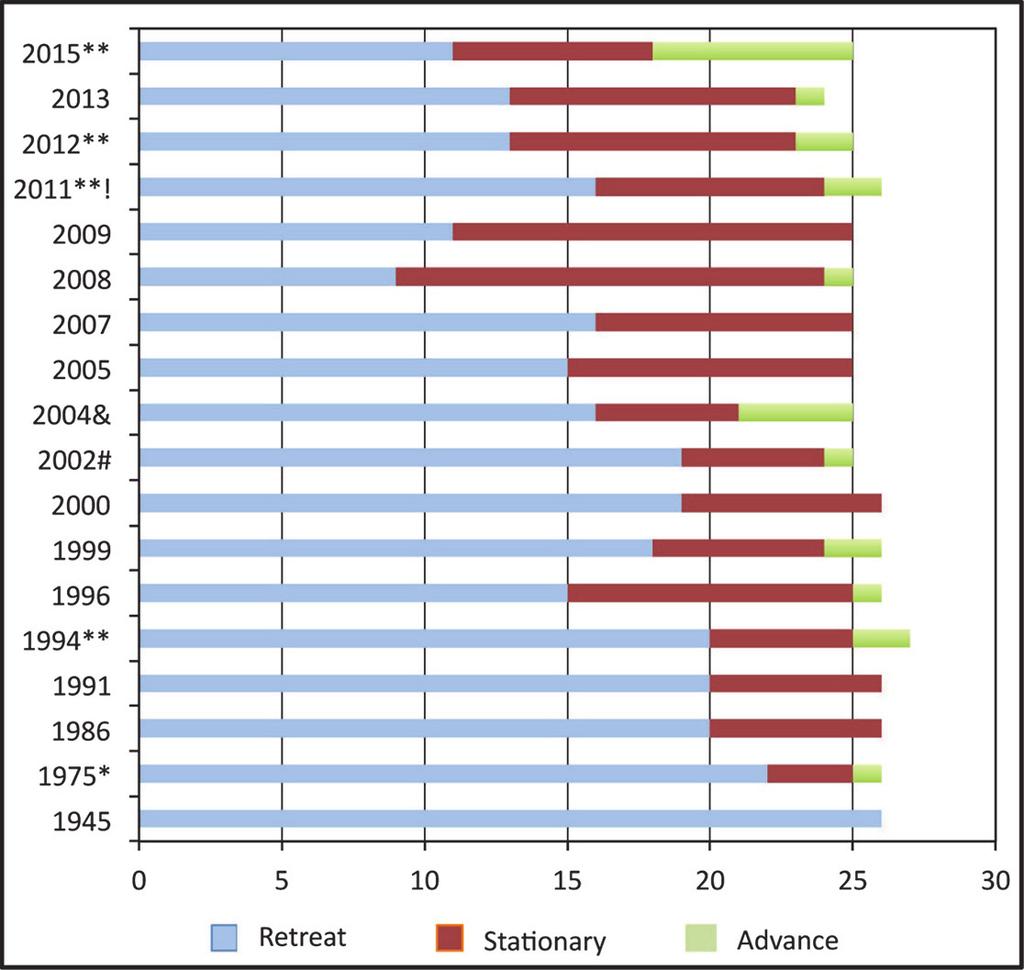
2 Glacier variations of Hielo Patagónico Norte, Chile, over 70 years from 1945 to 2015 Glaciers are known that in addition to inter-annual variations, they often fluctuate seasonally,., advance in winter and retreat in summer. Such annual moraines (washboard or De Geer moraines) are recognized at Gl. Soler (Aniya, 1985). So I made three winter aerial surveys in 2004 (July), 2005 (Aug.), and 2011 (July) to check if this is true for the HPN glaciers. I found that there were no substantial seasonal changes. Last time I reported the HPN variations was 2011 (Aniya 2011) in which the latest information was Since then, I made several aerial surveys and updated the variations to The purposes of this paper are to: (1) document in detail the variation of each glacier for (70 years); (2) discuss their characteristics; and (3) consider possible factors for variations. 2. Study Area Hielo Patagónico Norte (HPN) Hielo Patagónico Norte is located in Chile near the tip of South America between and S along about W (Fig. 1). It is about 100 km long from north to south and about km wide. The area was ca km2, with 28 major outlet glaciers when I made a comprehensive inventory of the outlet glacier (Aniya, 1988). About 20 years later, Rivera (2007) made another inventory using Landsat ETM+ data of 2001, in which measured area was ca km2, with 48 outlet glaciers including minor ones. In order to maintain the consistency, Aniya s inventory data are used in this study (Fig. 2). The highest mountain in Patagonia, Monte San Valentin (3910 m), is located at the northeast corner of the HPN. In the middle of the icefield near the eastern edge, Cerro (Co.) Arenales (3365 m) looms above the surrounding icefield whose elevations range m. To the south of Co. Arenales there are a few mountains with elevations m, which are limiting the east side of the icefield. Of the 28 major outlet glaciers, 21 have been monitored for variation by Aniya. Now 17 of these 21 outlet glaciers are calving glaciers in proglacial lakes, except one tidewater glacier, Glaciar (Gl.) San Rafael that is located at the lowest latitude in the world at S. Gl. San Rafael and San Quintin, which are located next to each other in the north-south direction, are two largest glaciers in the HPN with ca. 760 km2 each (Aniya, 1988). The HPN glaciers are temperate (Matsuoka and Naruse, 1999), characterized by large amounts of accumulation and ablation. The annual precipitation is estimated at ca mm (Escobar., 1992) on the icefield, while mm are reported from ground recordings at Laguna San Rafael and Gl. Exploradores (Aniya., 2011). The ice thickness is estimated at 1460 ± 500 m around the center part of the icefield from the gravity anomalies (Casassa, 1987). No mass balance study in the field of any glacier has yet been carried out in the HPN. Fig. 1. Location of the Hielo Patagónico Norte (HPN or Northern Patagonia Icefield) and major outlet glaciers. Fig. 2. Landsat image of the HPN (March 11, 2011), with names of outlet glaciers and GLOF lakes (Laguna Arco is located in front of Gl. Arco).
3 3. Data and Method 4. Results Grosse Reicher Gualas
4
5

6 Glacier variations of Hielo Patagónico Norte, Chile, over 70 years from 1945 to 2015 snouts, each with a small proglacial lake. Between 1945 and 1975, retreating rates were very small; 3 m a 1 and 8 m a 1 for the north and the south snout, respectively. After 1975 retreating rates picked up to ca. 20 to 30 m a 1 until Then, between 1996 and 1999 the south snout advanced ca. 310 m, while the north snout retreated ca. 280 m. What happened to the south snout next was snout disintegration with a retreat of 700 m in one year by A change at the south snout between 2000 and 2002 was an advance of ca. 450 m, while the north snout retreated ca. 550 m. After 2002 retreats of both the snouts were extensive by snout disintegration at each and by 2004, proglacial lakes of the two snouts coalesced into one, thereby resulting in one snout. The retreat in this twoyear period was ca m. Shortly after, the proglacial lake became drained only by the north outlet stream. These two episodes of an advance and an ensuing huge retreat in the following year were the results of an apparent advance due to crevasse stretching and subsequent snout disintegration. Interestingly after 2004, retreats became very slow with only ca. 200 m until Particularly the retreat between 2009 and 2013 was nil, suggesting that the glacier had reached equilibrium. During this period, we could see bedrock at some parts of the snout, indicating that the glacier was leaving the proglacial lake. Then between 2013 and 2015 this glacier advanced ca. 80 m. San Rafael (Fig. 4): The total retreat in the 70 years was ca m (59 m a 1). Although Heusser (1960) reported an advance in 1958/59 from field observation, the overall trend was retreat until 1975 at slow rates of m a 1. Retreat accelerated to 200 m a 1 for and during the retreating rate was one of the fastest in the HP at up to 300 m a 1. Then all of sudden, the right part advanced ca. 50 m while the left part retreated 60 m by 1994, with a small net gain of area. After stagnation during , it advanced again ca. 320 m by Between 1999 and 2002 it retreated fast at rates m a 1. The period saw another advance of ca. 150 m. After 2004, this glacier seems to have stabilized, although during a small part of the right side advanced ca. 50 m. So this glacier has made advances, although small, four times since the 1990 s. San Quintin (Fig. 5): Today this big glacier terminates in a huge proglacial lake with a width of ca. 6 km. Variation measurements were taken at three sides,., front (west side), north and south sides. The total retreat in the 70 years at the front is up to 4500 m (64 m a 1), while those at the N- and S-sides are ca m (21 m a 1) and ca m (44 m a 1), respectively. The front part retreated slowly until 1991 at rates up to 45 m a 1, but thinning had been considerable. During all sides retreated and the front part detached completely from the damming moraine so that those proglacial lakes located on the northern, western and southern margins coalesced together and the snout became circumscribed by a huge proglacial lake. Snout disintegration of the front commenced in at the right part, and a large retreat started during , when it retreated at rates m a 1. The period saw an accelerated retreat of ca m in two years at the right part of the front. Large retreat continued during Fig. 4. Variations of Gl. San Rafael from 1945 (44/45) to 2011 (July 17). A, trimetrogon; B, Chilean IGM. An arrow indicates the same spot for comparison. The glacier was protruding into Laguna San Rafael until the beginning of the 1980 s. Since 2004 the snout has been more or less stationary. Note: in D (winter scene) the valley-confined portion (ca. 3 km wide) of the glacier is not covered with snow. Monte San Lorenzo (3598 m) is a separate mountain area located on the Argentinean border.
 of the snout. The front still abutted the damming moraines.")
7 ANIYA Fig. 5. Variations of Gl. San Quintin from 1945 (44/45) to 2011 (July 17). A, trimetrogon; B, Chilean IGM. Arrows a to g indicate the same, corresponding spots. The width of the lake is ca. 6 km. On 1974 photograph, a proglacial lake can be recognized only at the north side (bottom of frame) of the snout. The front still abutted the damming moraines. Retreat between 1974 and 1986 was slow, but thinning was considerable. There were three large outlet streams (d, e and f) in 1974; but on D (2011), outlet stream at f was already dry and by 2014 outlet stream at e was also dry, due to lowering of the lake level. with ca m and during with ca m. Thus the snout disintegration lasted for about 13 years, because it occurred at different parts of the snout due to its large size. Then, retreat slowed down to rates m a 1 until During , the left part of the front advanced ca m, while the right part retreated a maximum of 500 m, with a net loss of area, though. Benito: retreated slowly and steadily from 1945 to 2004 at rates m a 1. After 2004 the snout retreated at much faster rates of more than 200 m a 1 until 2011, though with stagnation at The period saw a maximum retreat of 500 m, which was followed by 250 m retreat at all across the front during This rapid retreat continued to 2015 with a rate of 125 m a 1. HPN 1: was land terminating glacier until around 2007 when a proglacial lake, though small and shallow without damming terminal moraine, was formed, in which icebergs have rarely been observed. The total retreat in the 70 years is 3700 m (53 m a 1). Between 1945 and 1986, it slowly retreated at rates m a 1 for a total of 1700 m. During , it most actively retreated with rates ranging from 80 to 220 m a 1 at different parts of the snout. The period saw slow retreat with rates up to 17 m a 1. The following period was moderate retreat at m a 1. Then for it became nearly stationary with only 100 m retreat in 5 years. After 2009, it retreated with rates m a 1 at the center part of snout until HPN 2: From 1945 to 2002, retreat was modest with rates up to 88 m a 1. Retreat rates were accelerated after 2002, to a maximum of 200 m a 1 for , 300 m a 1 or , and 375 m a 1 for From 2007 to 2015, retreat rates were m a 1 with a stagnant period HPN 3: retreated rather slowly until 2000 at rates of m a 1. Between 2000 and 2002 this glacier had the first snout disintegration with ca m retreat. In the following period of , it advanced a maximum of ca. 150 m. Then, it retreated ca. 200 m by During retreats were moderate with rates of m a 1, at different parts of the snout. Between 2012 and 2013, this glacier underwent the second snout disintegration, thereby losing 1250 m. After 2013, it again advanced ca. 200 m by The total retreat in the 70 years is 3900 m. It is very interesting to note that this glacier made an advance after snout disintegration. Steffen (Fig. 6): Variation data for this glacier were taken for the front (south) and the east side of the snout until 2011, when it became unnecessary to take data for the E-side due to the front retreat. The front retreated a total of 5100 m (75 m a 1) in the 70 years, which is the second largest in the HPN, next only to Gl. Reicher, while the E-side retreated 1700 m (28 m a 1) in 66 years. During the 70 years, the front retreated at rates ranging from 23 m a 1 in the beginning to a maximum of 450 m a 1 after Meantime there were one period of stagnation in and two periods of advance; a maximum of 300 m in and ca. 200 m in Each advance was followed by a large retreat,., 400 m a 1 ( ) and 250 m a 1 ( ). Calving has been very active and many large icebergs are normally observed in the proglacial lake, implying that the snout is floating. Gl. Steffen have two side lakes on the right side,

8 Glacier variations of Hielo Patagónico Norte, Chile, over 70 years from 1945 to 2015 Fig. 6. Variations of Gl. Steffen. A, trimetrogon; B, Chilean IGM. Arrows a and b indicate the same spot. From 1945 to 1974, it retreated rather slowly, but after that retreat was rapid with very active calving, thereby producing many large icebergs. C is a winter scene and the lake was frozen with large icebergs. The width of the proglacial lake in 1974 photo is ca. 1.8 km. Laguna de los Témpanos (lower) and Laguna Bolson (upper). It was found out recently that Laguna de los Témpanos had had GLOFs (Glacial-Lake Outburst Flood) since at least the mid 1980 s (Aniya, 2014), which will be discussed later. Piscis: retreated between 1945 and 1975 at an average rate of ca. 25 m a 1 for a total of 760 m in 30 years. The rate slowed down until 1994, retreating only ca. 140 m. Then, this glacier advanced slightly ca. 30 m by 1996 at the right part. After 1996, this glacier had retreated ca. 450 m by 2008, with a stagnant period of Since 2008, it has been stagnant. Pared Sur: The snout area is now extensively covered with debris, which protects glacier ice underneath, resulting in very slow wasting. However, the snout had not been as extensively covered as today until around 1986 and it made rapid retreat during with 1000 m (33 m a 1). By 1986 retreat amounted to 1250 m. After 1986, however, there has been no discernible retreat, although thinning. Pared Norte: Since 1945, this glacier has been slowly retreating, with a few stagnant periods, at rates of ca m a 1 until 2013 for a total retreat of ca m. For , retreat accelerated to 250 m. Arco: used to be a calving glacier (Figs. 7 A and 7B) and during the 1950 s the proglacial lake, Laguna Arco, had a GLOF every year or two (Tanaka, 1980), which drained under the right side of Gl. Colonia. It had become land terminating by 1975 due to lowering of the lake level (Aniya and Enomoto, 1986). Its retreat is the least in the HPN in terms of the area with 0.46 km 2. Retreat was recognized in two periods of (70 m a 1) and (450 m a 1). This is probably because the snout is extensively covered with debris, and terminates in a narrow valley with high walls where sunshine is limited. Colonia (Fig. 7): Retreat had been slow and steady from 1945 to 2000 with rates of less than 10 m to 50 m a 1, with two periods of stagnation at and After 2000, retreat started accelerating to 75 m a 1 to 2002, 125 m a 1 to 2004, 350 m a 1 to 2005, 100 m a 1 to 2007, and 350 m a 1 to The year 2008 saw the first GLOF of Lago Cachet Dos located on the left side of and dammed by this glacier, which will be discussed later. Eight GLOFs recognized by 2013 may have contributed to rapid retreats. Cachet: The snout used to terminate as one in the proglacial lake, Cachet Uno, until 2002 when the snout separated due to extensive retreat of ca m since Therefore, after 2002 statistics were taken as Cachet north and Cachet west. Soon after separating, Cachet N became land terminating and retreated fast over a cliff until Then it has stagnated just above the cliff top. Cachet W retreated about 150 m until 2005 and then stagnated for , before resuming slow retreat until Between 2013 and 2015, the center part of the snout advanced about 50 m. Nef: had a long snout in the proglacial lake in 1945 and in 30 years to 1975, the snout only narrowed by m without retreat. Until 1991 main wasting of the snout was by narrowing of m than front retreat of ca. 350 m. Then, during , the snout advanced ca. 300 m with conspicuous bending in the proglacial lake, suggesting snout floating. This is probably the first time that the snout of a temperate glacier was suspected to be floating

9 ANIYA Fig. 7. Variations of Gl. Arco and Colonia. A, trimetrogon; B, Chilean IGM. An arrow indicates the same spot. Gl. Arco was not debriscovered in 1945 (44/45) and snout was emptying into the proglacial lake. In 1974, debris had accumulated at the snout and the snout was no longer emptying in the lake due to lowering of the lake level. In A, B and C, snout margin of Gl. Colonia is dark with debris that was brought to surface by thrusting, which actively continued until around Rapid retreat between 2011 and 2014, probably influenced by GLOFs of Lago Cachet Dos that started in By 2014, proglacial lakes on either side of the snout have coalesced, thereby becoming a large single lake. in Patagonia. Following this advance, the snout was found disintegrated between 1994 and 1996, thereby retreating 2800 m. This was the second snout disintegration caught in the HPN, after Gl. Reicher. Strong retreat continued until 1999 with a maximum of 1200 m. Rapid retreat slowed down considerably between 1999 and 2002, with a total of only 150 m. The period saw an advance of ca. 200 m, which was followed by slow yet steady retreat at rates m a 1 until Soler (Figs. 8 and 9): The total retreat is ca. 850 m between 1945 and 2015 with an average rate of 12 m a 1, which is the third smallest in the HPN, next only to Gl. León and Exploradores. This glacier had been slowly, steadily retreating and a small proglacial lake was formed on either side of the snout tip around Due to continued slow retreat, during the snout tip broke up from the damming moraine, thereby two small proglacial lakes coalesced into one, resulting in 300 m retreat, which was by far the largest rate for this glacier. After 2004, it was more or less stagnant until Then, it started advancing, with a gain of 150 m by 2011, when many other HPN glaciers were retreating. With the continued advance it gained another ca. 50 m for While did not see any change, it again advanced ca. 80 m between 2013 and 2015, and the snout tip reached the damming moraine, thereby dividing the proglacial lake into two. These advances are interpreted to be the result of crevasse stretching, which is the phenomenon preceding the imminent snout disintegration. León: consists of three branches, León Norte, Central and Sur that coalesce just above the snout front in Lago Leones. Although the snout is without debris cover, this glacier has varied very little in the 70 years with retreat of only ca. 350 m. It retreated for , but after 1994 it has been stationary more or less with occasional small advances at and and retreats. Fiero: is almost completely covered with debris from the southeast side of Monte San Valentin. It had retreated slowly between 1945 and 2011 in the proglacial lake at a rate of ca. 15 m a 1. However, after 2011, it suddenly

10 Exploradores 5. Discussion

11 ANIYA Fig. 9. Detailed variations of Gl. Soler using (semi) vertical photographs of the snout area from 1974 (Nov. 8) to 2014 (Dec. 2). A and D are taken by Chilean IGM, while the rest are mosaics of a few tens of aerial survey photographs. Since they are uncontrolled, scales vary greatly. The width of the glacier is ca. 2 km. G is a winter scene; although there was no snow at all (elevation 350 m), the proglacial lake was frozen. Note: On C, a line of thrust moraines (white strip parallel to the front shape) appeared. On D, a proglacial lake is recognized. On F, a proglacial lake is clearly recognized on either side of the snout. Gl. Soler started advancing in 2011 and the 2014 photo shows that protruding snout was split after reaching the damming moraine, indicating that advance was temporal and snout disintegration was imminent.

12 Glacier variations of Hielo Patagónico Norte, Chile, over 70 years from 1945 to 2015 Fig. 10. Variations of Gl. Exploradores. A and B are taken by Chilean IGM, while the rest are uncontrolled mosaics of aerial survey photographs. C and D are incomplete coverage. The width of the glacier is ca km. D is a winter scene, but without a trace of snow at all (elevation, less than 200 m). Although the front edge does not show conspicuous retreat, surface of the snout area has become more pitted, indicating thinning. Note: upstream of the debris-covered snout, there are many lumps of debris that are brought up to surface by thrusting. Since the HPN is located at the southern Westerly zone, the east west contrast in meteorology, climate and glacier conditions is notable (Nakajima, 1985; Warren and Sugden, 1992). Table 2 shows statistics of those glaciers located on the west side (Reicher to Steffen, 9 glaciers) and on the east side (Grosse to Piscis, 12 glaciers). The west side lost a total area of km2 in the 70 years, which translates to 1.38 km2 a 1 or km2 a 1 glacier 1, while the east side lost a total area of km2, which translates to 0.43 km2 a 1 or km2 a 1 glacier 1. Thus, the total area lost on the west side is more than three times that on the east side. It is argued that a larger glacier can lose more area than a smaller glacier and this was checked using the glacier surface area of 1974/75 (Aniya, 1988) as the base, because there is no data for 1944/45. Table 2 shows that the area loss per glacier surface ranges widely from 1.12 % of Gl. Arco to % of Gl. Cachet, both located on the east side, and there is no definite relationship between the glacier surface area and the area lost. Large ones include Gl. Guals with % on the northwest side, and Gl. Pared Sur with 7.13 % and Gl. Piscis with 7.08 %, both on the southeast corner of the HPN. The total glacier area of those on the west side is km2, while that on the east side is km2 (Table 2), making the area loss per glacier area 3.41 % and 2.80 %, respectively. So, also in terms of the area loss per glacier surface, there is substantial difference between those on the west and the east side. Since Gl. San Rafael and San Quintin are two exceptionally large ones in the HPN, statistics excluding these two from the west side are considered. Then, the total glacier area of seven glaciers on the west side becomes km 2 and the area lost by these seven glaciers is km 2, which translates to 3.33 %, smaller than the inclusive figure. Individual figures of Gl. San Rafael and San Quintin are 1.68 % and 5.31 %, respectively; widely different figures despite the similar topoclimatic situations. For a comparison, Gl. Steffen, the third largest, has 2.42 % and Gl. Colonia, the fourth largest, has 1.35 %. Gl. Arco that lost the smallest area has 1.12 %. Accumulation-Area Ratio (AAR) also has no particular relationship with the area loss as shown in Table 2. Next, the north-south contrast was also examined. Considering the location of the accumulation area, those considered to be located on the north side include the following 10 glaciers: San Quintin, San Rafael, Reicher, Gualas, Grosse, Exploradores, Fiero, León, Soler and Nef, with a total glacier surface area of km2. Those on

13 Gl. Reicher:
14 Gl. Gualas: Gl. San Quintin Gl. Benito: Gl. HPN3: Gl. Steffen: Gl. Colonia: Gl. Nef
15 Gl. Reicher SW snout Gl. Gualas Gl. San Rafael Gl. HPN3
16 Gl. León Gl. Soler Gl. Nef Gl. Piscis Gl. Grosse: Gl. Fiero: Gl. Exploradores: Gl. Arco: Gl. Pared Sur:

17 ANIYA Fig. 12. Three GLOF lakes. A and B are Laguna del Co. Largo, head of Soler Valley; C E are Lago Cachet Dos on the left side of Gl. Colonia; and F and G are Laguna de los Témpanos on the right side of Gl. Steffen. Arrows in the same area indicate the same spot. In A, lake labeled no name had a GLOF probably in the 17th century. In B, strandline of old water level is ca. 97 m higher. In E, the distinctive strandline is clearly recognized and white ice cliff suggests a recent GLOF. In F, there are many stranded icebergs left after discharge near the far end of the lake. In G, lake was filled in with water again. SR retreated between 1975 and 1986 at a very rapid rate of 200 m a 1, thereby having lost an area of 4.83 km2 (0.44 km2 a 1), while the front of SQ retreated at a rate of less than 45 m a 1 with a loss of 0.87 km2 (0.08 km2 a 1). The behavior of SQ had changed after 1986, when it commenced a very rapid retreat that had lasted until around 2012 (see Fig. 3), during which time (26 years), it lost an area of km2 (1.19 km2 a 1), by far the largest in the HPN. On the other hand, during SR accelerated the previous rapid rate to 300 m a 1; however, it abruptly stopped retreating after It even advanced four times in periods , , and , although temporarily. Therefore, SR can be regarded as having been more or less stationary for 24 years since 1991, when the neighboring SQ had been retreating at a very fast rate of 1.25 km 2 a 1 until After 2012, retreat of SQ slowed down to a loss of 0.69 km2 to 2013, and in it all of sudden slowed down considerably to 0.01 km 2 a 1, because a part of the snout made an advance., Fig. 12 One of the severe consequences of global warming related to glaciers that threaten local inhabitants is GLOF. This is a phenomenon in which a lake associated with glacier drains a huge quantity of lake water in a short period of time. There are in general two types of GLOFs, depending upon the location of a lake relative to glacier; proglaciallake outburst and side-lake discharge. Proglacial-lake outburst mainly occurs when the damming moraine is breached, for example by excessive, strong overflow accompanying severe erosion. Another type, sudden side-lake discharge may occur when a glacial lake located on the side of a glacier drains underneath the blocking glacier body quickly. This typically occurs when the blocking glacier cannot withstand the hydrostatic pressure of the side lake, which is caused by either the increased volume of lake water or
18 Laguna Arco Laguna del Co. Largo Lago Cachet Dos Laguna de los Témpanos 6. Factors for Variations
19 7. Concluding Remarks Acknowledgments
20 References A A
Glacier variations of Hielo Patagónico Norte, Chile, for +3.././,**./*/
 Bulletin of Glaciological Research,. (,1) /3 1 Japanese Society of Snow and Ice 59 Glacier variations of Hielo Patagónico Norte, Chile, for +3.././,.// Masamu ANIYA Graduate School of Life and Environmental
Recent glacier advances at Glaciar Exploradores, Hielo Patagónico Norte, Chile
 Bulletin of Glaciological Research,. (,**1).3 /1 Japanese Society of Snow and Ice 49 Recent glacier advances at Glaciar Exploradores, Hielo Patagónico Norte, Chile Masamu ANIYA +, Gonzalo BARCAZA, and
The Potentially Dangerous Glacial Lakes
 Chapter 11 The Potentially Dangerous Glacial Lakes On the basis of actively retreating glaciers and other criteria, the potentially dangerous glacial lakes were identified using the spatial and attribute
THE DISEQUILBRIUM OF NORTH CASCADE, WASHINGTON GLACIERS
 THE DISEQUILBRIUM OF NORTH CASCADE, WASHINGTON GLACIERS CIRMOUNT 2006, Mount Hood, OR Mauri S. Pelto, North Cascade Glacier Climate Project, Nichols College Dudley, MA 01571 peltoms@nichols.edu NORTH CASCADE
Tidewater Glaciers: McCarthy 2018 Notes
 Tidewater Glaciers: McCarthy 2018 Notes Martin Truffer, University of Alaska Fairbanks June 1, 2018 What makes water terminating glaciers special? In a normal glacier surface mass balance is always close
TEACHER PAGE Trial Version
 TEACHER PAGE Trial Version * After completion of the lesson, please take a moment to fill out the feedback form on our web site (https://www.cresis.ku.edu/education/k-12/online-data-portal)* Lesson Title:
Recrystallization of snow to form LARGE. called FIRN: like packed snowballs. the weight of overlying firn and snow.
 Chapter 11 Glaciers BFRB P. 103-104, 104, 108, 117-120120 Process of Glacier Formation Snow does NOT melt in summer Recrystallization of snow to form LARGE crystals of ice (rough and granular) called
Climate Change Impact on Water Resources of Pakistan
 Pakistan Water and Power Development Authority (WAPDA) Climate Change Impact on Water Resources of Pakistan Glacier Monitoring & Research Centre Muhammad Arshad Pervez Project Director (GMRC) Outline of
Observation of cryosphere
 Observation of cryosphere By Sagar Ratna Bajracharya (email: sagar.bajracharya@icimod.org) Samjwal Ratna Bajracharya Arun Bhakta Shrestha International Centre for Integrated Mountain Development Kathmandu,
Glaciology. Water. Glacier. Moraine. Types of glacier-dammed lakes. Mechanics of jökulhlaup
 A Jökulhlaup Jökulhlaup. Catastrophic events where large amounts of water are suddenly discharged. Jökulhlaup s are a sudden and rapid draining of a glacier dammed lake or of water impounded within a glacier.
GLACIER STUDIES OF THE McCALL GLACIER, ALASKA
 GLACIER STUDIES OF THE McCALL GLACIER, ALASKA T John E. Sater* HE McCall Glacier is a long thin body of ice shaped roughly like a crescent. Its overall length is approximately 8 km. and its average width
Snow, Glacier and GLOF
 Snow, Glacier and GLOF & Report on Demonstration River Basin Activities Upper Indus Basin The 5th International Coordination Group (ICG) Meeting GEOSS Asian Water Cycle Initiative (AWCI) Tokyo, Japan,
Glacial Geomorphology Exercise
 James Madison University Field Course in western Ireland Glacial Geomorphology Exercise 3-day road log (abbreviated) Striations Large kame terrace Cirque with moraines Kame delta Striations Eskers Raised
Mendenhall Glacier Facts And other Local Glaciers (updated 3/13/14)
") University of Alaska Southeast School of Arts & Sciences A distinctive learning community Juneau Ketchikan Sitka Mendenhall Glacier Facts And other Local Glaciers (updated 3/13/14) This document can be
University of Alaska Southeast School of Arts & Sciences A distinctive learning community Juneau Ketchikan Sitka Mendenhall Glacier Facts And other Local Glaciers (updated 3/13/14) This document can be
Geomorphology. Glacial Flow and Reconstruction
 Geomorphology Glacial Flow and Reconstruction We will use simple mathematical models to understand ice dynamics, recreate a profile of the Laurentide ice sheet, and determine the climate change of the
Glaciers. Reading Practice
 Reading Practice A Glaciers Besides the earth s oceans, glacier ice is the largest source of water on earth. A glacier is a massive stream or sheet of ice that moves underneath itself under the influence
GEOSPATIAL ANALYSIS OF GLACIAL HAZARDS PRONE AREAS OF SHIGAR AND SHAYOK BASINS OF PAKISTAN. By Syed Naseem Abbas Gilany
 GEOSPATIAL ANALYSIS OF GLACIAL HAZARDS PRONE AREAS OF SHIGAR AND SHAYOK BASINS OF PAKISTAN By Syed Naseem Abbas Gilany PRESENTATION OUTLINE Introduction Problem Statement / Rationale Objectives Material
Glaciers Earth 9th Edition Chapter 18 Mass wasting: summary in haiku form Glaciers Glaciers Glaciers Glaciers Formation of glacial ice
 1 2 3 4 5 6 7 8 9 10 11 12 13 14 15 Earth 9 th Edition Chapter 18 Mass wasting: summary in haiku form Ten thousand years thence big glaciers began to melt - called "global warming." are parts of two basic
Short-tertn variations in flow velocity of Glaciar Soler, Patagonia, Chile
 Journal of Glaciology, Vo!. 38, No. 128, 1992 Short-tertn variations in flow velocity of Glaciar Soler, Patagonia, Chile RNJ NARUS, nstitute of Low Temperature Science, Hokkaido University, Sapporo 6,
MAURI PELTO, Nichols College, Dudley, MA
 MAURI PELTO, Nichols College, Dudley, MA 01571(mspelto@nichols.edu) Advice I am looking for Better schemes for utilizing atmospheric circulation indices to provide a better forecast for glacier mass balance?
Climate Change and State of Himalayan Glaciers: Issues, Challenges and Facts
 Climate Change and State of Himalayan Glaciers: Issues, Challenges and Facts D.P. Dobhal dpdobhal@wihg.res.in Wadia Institute of Himalayan Geology Dehra Dun Major Issues Are the Himalayan glaciers receding
Lidar Imagery Reveals Maine's Land Surface in Unprecedented Detail
 Maine Geologic Facts and Localities December, 2011 Lidar Imagery Reveals Maine's Land Surface in Unprecedented Detail Text by Woodrow Thompson, Department of Agriculture, Conservation & Forestry 1 Introduction
I. Types of Glaciers 11/22/2011. I. Types of Glaciers. Glaciers and Glaciation. Chapter 11 Temp. B. Types of glaciers
 Why should I care about glaciers? Look closely at this graph to understand why we should care? and Glaciation Chapter 11 Temp I. Types of A. Glacier a thick mass of ice that originates on land from the
Integration Of Reflectance To Study Glacier Surface Using Landsat 7 ETM+: A Case Study Of The Petermann Glacier In Greenland
 Integration Of Reflectance To Study Glacier Surface Using Landsat 7 ETM+: A Case Study Of The Petermann Glacier In Greenland Félix O. Rivera Santiago Department Of Geology, University Of Puerto Rico, Mayaguez
MONITORING RECENT GLACIER VARIATIONS IN THE SOUTHERN PATAGONIA ICEFIELD, UTILIZING REMOTE SENSING DATA
 MONITORING RECENT GLACIER VARIATIONS IN THE SOUTHERN PATAGONIA ICEFIELD, UTILIZING REMOTE SENSING DATA ABSTRACT Masamu Aniya Institute of Geoscience, University oftsukuba, Japan Renji Naruse Institute
Fifty-Year Record of Glacier Change Reveals Shifting Climate in the Pacific Northwest and Alaska, USA
 Fact Sheet 2009 3046 >> Pubs Warehouse > FS 2009 3046 USGS Home Contact USGS Search USGS Fifty-Year Record of Glacier Change Reveals Shifting Climate in the Pacific Northwest and Alaska, USA Fifty years
glacier Little Ice Age continental glacier valley glacier ice cap glaciation firn glacial ice plastic flow basal slip Chapter 14
 Little Ice Age glacier valley glacier continental glacier ice cap glaciation firn glacial ice plastic flow basal slip glacial budget zone of accumulation zone of wastage glacial surge abrasion glacial
Alaskan landscape evolution and glacier change in response to changing climate
 Alaskan landscape evolution and glacier change in response to changing climate Following the publication of two pictures comparing the length of the Muir Glacier in Alaska, USA in the June 2005 issue of
PHYSICAL GEOGRAPHY GEOGRAPHY EARTH SYSTEMS COASTAL SYSTEMS FLUVIAL SYSTEMS
 PHYSICAL GEOGRAPHY EARTH SYSTEMS FLUVIAL SYSTEMS COASTAL SYSTEMS PHYSICAL GEOGRAPHY CORRIES / CIRQUES A Corrie or Cirque is the armchair shaped hollow that was the birthplace of a glacier. It has steep,
READING QUESTIONS: Glaciers GEOL /WI 60 pts. a. Alpine Ice from larger ice masses flowing through a valley to the ocean
 READING QUESTIONS: Glaciers GEOL 131 18/WI 60 pts NAME DUE: Tuesday, March 13 Glaciers: A Part of Two Basic Cycles (p. 192-195) 1. Match each type of glacier to its description: (2 pts) a. Alpine Ice from
Glaciers. Clicker Question. Glaciers and Glaciation. How familiar are you with glaciers? West Greenland. Types of Glaciers.
 Chapter 21 Glaciers A glacier is a large, permanent (nonseasonal) mass of ice that is formed on land and moves under the force of gravity. Glaciers may form anywhere that snow accumulation exceeds seasonal
Part 1 Glaciers on Spitsbergen
 Part 1 Glaciers on Spitsbergen What is a glacier? A glacier consists of ice and snow. It has survived at least 2 melting seasons. It deforms under its own weight, the ice flows! How do glaciers form? Glaciers
BLASTING GLACIAL ICE AND SNOW ABSTRACT
 BLASTING GLACIAL ICE AND SNOW HERB BLEUER ABSTRACT This presentation, with the aid of slides, is about methods of blasting large quantities of glacial ice and snow. The project illustrated here involved
Rapid decrease of mass balance observed in the Xiao (Lesser) Dongkemadi Glacier, in the central Tibetan Plateau
 Dongkemadi Glacier, in the central Tibetan Plateau") HYDROLOGICAL PROCESSES Hydrol. Process. 22, 2953 2958 (2008) Published online 8 October 2007 in Wiley InterScience (www.interscience.wiley.com).6865 Rapid decrease of mass balance observed in the Xiao
HYDROLOGICAL PROCESSES Hydrol. Process. 22, 2953 2958 (2008) Published online 8 October 2007 in Wiley InterScience (www.interscience.wiley.com).6865 Rapid decrease of mass balance observed in the Xiao
Glaciers and Glaciation Earth - Chapter 18 Stan Hatfield Southwestern Illinois College
 Glaciers and Glaciation Earth - Chapter 18 Stan Hatfield Southwestern Illinois College Glaciers Glaciers are parts of two basic cycles: 1. Hydrologic cycle 2. Rock cycle A glacier is a thick mass of ice
AGAP Antarctic Research Project Visualizing Data Learning About Antarctica From RADAR Data? Student Version
 AGAP Antarctic Research Project Visualizing Data Learning About Antarctica From RADAR Data? Student Version Name Date Image of Subglacial Lake network courtesy of NSF Ice Sheet: A large glacier that covers
Chapter 16 Glaciers and Glaciations
 Chapter 16 Glaciers and Glaciations Name: Page 419-454 (2nd Ed.) ; Page 406-439 (1st Ed.) Part A: Anticipation Guide: Please read through these statements before reading and mark them as true or false.
glacial drift: all deposits associated with glaciation; covers 8% of Earth s surface above sealevel, and 25% of North America
 Glacial depositional features glacial drift: all deposits associated with glaciation; covers 8% of Earth s surface above sealevel, and 25% of North America i) nonstratified drift till: transported & deposited
Glaciers. Valley or Alpine glaciers. Ice sheets. Piedmont - foot of the mountain glaciers. Form in mountainous areas Move downslope in valleys
 Glaciers & Ice Ages Glaciers Valley or Alpine glaciers Form in mountainous areas Move downslope in valleys Ice sheets Move outward from center Continental glaciers - large scale, ice age type. Presently
SUPPLEMENTARY INFORMATION
 SUPPLEMENTARY INFORMATION doi: 10.1038/ngeo1122 Global sea-level contribution from the Patagonian Icefields since the Little Ice Age maximum Methods Error Assessment Supplementary Figures 1 and 2 Supplementary
READING QUESTIONS: Chapter 7, Glaciers GEOL 131 Fall pts. a. Alpine Ice from larger ice masses flowing through a valley to the ocean
 READING QUESTIONS: Chapter 7, Glaciers GEOL 131 Fall 2018 63 pts NAME DUE: Tuesday, October 23 Glaciers: A Part of Two Basic Cycles (p. 192-195) 1. Match each type of glacier to its description: (2 pts)
Comparison Pictures of Receding Glaciers
 Comparison Pictures of Receding Glaciers In the photo above, the west shoreline of Muir Inlet in Alaska's Glacier Bay National Park & Preserve is shown as it appeared in 1895. Notice the lack of vegetation
47I THE LAS ANIMAS GLACIER.
 THE LAS ANIMAS GLACIER. ONE of the largest of the extinct glaciers of the Rocky Mountains was that which occupied the valley of the Las Animas river. This stream originates in the San Juan mountains in
J. Oerlemans - SIMPLE GLACIER MODELS
 J. Oerlemans - SIMPE GACIER MODES Figure 1. The slope of a glacier determines to a large extent its sensitivity to climate change. 1. A slab of ice on a sloping bed The really simple glacier has a uniform
Glacial lakes as sentinels of climate change in Central Himalaya, Nepal
 Glacial lakes as sentinels of climate change in Central Himalaya, Nepal Sudeep Thakuri 1,2,3, Franco Salerno 1,3, Claudio Smiraglia 2,3, Carlo D Agata 2,3, Gaetano Viviano 1,3, Emanuela C. Manfredi 1,3,
NORTH CASCADE SLACIER CLIMATE PROJECT Director: Dr. Mauri S. Pelto Department of Environmental Science Nichols College, Dudley MA 01571
 NORTH CASCADE SLACIER CLIMATE PROJECT Director: Dr. Mauri S. Pelto Department of Environmental Science Nichols College, Dudley MA 01571 INTRODUCTION The North Cascade Glacier-Climate Project was founded
Chapter 7 Snow and ice
 Chapter 7 Snow and ice Throughout the solar system there are different types of large ice bodies, not only water ice but also ice made up of ammonia, carbon dioxide and other substances that are gases
Geography 120, Instructor: Chaddock In Class 13: Glaciers and Icecaps Name: Fill in the correct terms for these descriptions: Ablation zone: n zne:
 Geography 120, Instructor: Chaddock In Class 13: Glaciers and Icecaps Name: Fill in the correct terms for these descriptions: Ablation zone: The area of a glacier where mass is lost through melting or
Eastern Snow Conference: 2017 Student Award Recipient
 Eastern Snow Conference: 2017 Student Award Recipient Presentation title: Tracking changes in iceberg calving events and characteristics from Trinity and Wykeham Glaciers, SE Ellesmere, Canada Authors:
Glaciers. Glacier Dynamics. Glaciers and Glaciation. East Greenland. Types of Glaciers. Chapter 16
 Chapter 16 Glaciers A glacier is a large, permanent (nonseasonal) mass of ice that is formed on land and moves under the force of gravity. Glaciers may form anywhere that snow accumulation exceeds seasonal
GLACIATION. The Last Ice Age (see Chapter 12) and. Pleistocene Ice Cap. Glacial Dynamics 10/2/2012. Laurentide Ice Sheet over NYS
 and. Pleistocene Ice Cap. Glacial Dynamics 10/2/2012. Laurentide Ice Sheet over NYS") GLACIATION and New York State Prof. Anthony Grande The Last Ice Age (see Chapter 1) The Pleistocene Epoch began 1.6 mya. During this time, climates grew colder. There were numerous ice ages starting 100,000000
GLACIATION and New York State Prof. Anthony Grande The Last Ice Age (see Chapter 1) The Pleistocene Epoch began 1.6 mya. During this time, climates grew colder. There were numerous ice ages starting 100,000000
Little Ice Age advances of Glaciar Perito Moreno, Hielo Patagónico Sur, South America
 Bulletin of Glaciological Research -* (,*+,) +2 Japanese Society of Snow and Ice 1 Little Ice Age advances of Glaciar Perito Moreno, Hielo Patagónico Sur, South America Masamu ANIYA and Pedro SKVARCA +,
HYDROLOGY OF GLACIAL LAKES, FORT SISSETON AREA
 PROC. S.D. ACAD. SCI., VOL. 77 (1998) 59 HYDROLOGY OF GLACIAL LAKES, FORT SISSETON AREA Perry H. Rahn Department of Geology & Geological Engineering South Dakota School of Mines and Technology Rapid City,
Glaciers. Glacier Dynamics. Glacier Dynamics. Glaciers and Glaciation. Types of Glaciers. Chapter 15
 Chapter 15 Glaciers and Glaciation Glaciers A glacier is a large, permanent (nonseasonal) mass of ice that is formed on land and moves under the force of gravity. Glaciers may form anywhere that snow accumulation
Expansion of glacier lakes in recent decades in the Bhutan Himalayas
 Debris-Covered Glaciers (Proceedings of a workshop held at Seattle, Washington, USA, September 2000). IAHS Publ. no. 264, 2000. 165 Expansion of glacier lakes in recent decades in the Bhutan Himalayas
GLOFs from moraine-dammed lakes: their causes and mechanisms V. Vilímek, A. Emmer
 GLOFs from moraine-dammed lakes: their causes and mechanisms V. Vilímek, A. Emmer Department of Physical Geography and Geoecology, Faculty of Science, Charles University, Prague, Czech Republic vilimek@natur.cuni.cz
PREMIUM TRAFFIC MONITOR MARCH 2009
 PREMIUM TRAFFIC MONITOR MARCH 2009 KEY POINTS The fall in passenger numbers slowed in March, to a decline of 9.3% following February s 9.6% fall. However, this slowdown was entirely due to February s fall
HEATHROW COMMUNITY NOISE FORUM
 HEATHROW COMMUNITY NOISE FORUM 3Villages flight path analysis report January 216 1 Contents 1. Executive summary 2. Introduction 3. Evolution of traffic from 25 to 215 4. Easterly departures 5. Westerly
Hydrology Input for West Souris River IWMP
 Hydrology Input for West Souris River IWMP Prepared by: Mark Lee Manitoba Water Stewardship 1 1 1 Overall view of: drainage area watershed characteristics gauging stations meteorological stations Runoff
How Glaciers Change the World By ReadWorks
 How Glaciers Change the World How Glaciers Change the World By ReadWorks Glaciers are large masses of ice that can be found in either the oceans or on land. These large bodies of frozen water have big
Introduction to Safety on Glaciers in Svalbard
 Introduction to Safety on Glaciers in Svalbard Content Basic info on Svalbard glaciers Risk aspects when travelling on glaciers Safe travel on glaciers UNIS safety & rescue equipment Companion rescue in
Laguna San Rafael - Full Day with Río Exploradores
 Laguna San Rafael - Full Day with Río Exploradores One day return trip to Laguna San Rafael from Bahia Exploradores. Time table: 07.00 Leave Puerto Tranquilo for Bahia Exploradores 08.45 Arrive to La Teresa
APPENDIX E GLACIERS AND POLAR ICE CAPS
 APPENDIX E GLACIERS AND POLAR ICE CAPS GLACIERS The dictionary defines a glacier as a large mass of ice and snow that forms in areas where the rate of snowfall constantly exceeds the rate at which the
Warming planet, melting glaciers
 Warming planet, melting glaciers Arun B Shrestha abshrestha@icimod.org International Centre for Integrated Mountain Development Kathmandu, Nepal Asia-Pacific Youth forum on Climate Actions and Mountain
What is a Glacier? GLACIOLOGY vs. GLACIAL GEOLOGY. snow corn firn glacier snow = neve ice
 What is a Glacier? Mass of Ice Derived from Snow Lasts from Year to Year Moves Due to Its Own Weight GLACIOLOGY vs. GLACIAL GEOLOGY Transformation of Snow to Glacial Ice snow corn firn glacier snow = neve
POLAR I.C.E. (Interactive Climate Education)
") POLAR I.C.E. (Interactive Climate Education) 1 WHAT IS HAPPENING TO ANTARCTICA S PINE ISLAND GLACIER? Teacher Supporting Information Use your understanding of glacier science to figure out what is happening
POLAR I.C.E. (Interactive Climate Education) 1 WHAT IS HAPPENING TO ANTARCTICA S PINE ISLAND GLACIER? Teacher Supporting Information Use your understanding of glacier science to figure out what is happening
Geologic Trips, Sierra Nevada
 ISBN 0-9661316-5-7 GeoPress Excerpt from Geologic Trips, Sierra Nevada by Ted Konigsmark All rights reserved. No part of this book may be reproduced without written permission, except for critical articles
宇宙から見た中央アジア, パミールのフェドチェンコ氷河の特徴
 Geographical Studies 宇宙から見た中央アジア, パミールのフェドチェンコ氷河の特徴 * 岩田修二 キーワード 要旨 FG Shan, where precipitation is greatest in summer. 3 General configuration of Fedchenko Glacier (1) Plan form of the glacial basin Fedchenko
Environmental Impact Assessment in Chile, its application in the case of glaciers. Carlos Salazar Hydro21 Consultores Ltda.
 Environmental Impact Assessment in Chile, its application in the case of glaciers Carlos Salazar Hydro21 Consultores Ltda. carlos.salazar@hydro21.cl Introduction Changes in the environmental law in Chile
Shrubs and alpine meadows represent the only vegetation cover.
 Saldur river General description The study area is the upper Saldur basin (Eastern Italian Alps), whose elevations range from 2150 m a.s.l. (location of the main monitoring site, LSG) and 3738 m a.s.l.
2. (1pt) From an aircraft, how can you tell the difference between a snowfield and a snow-covered glacier?
 From an aircraft, how can you tell the difference between a snowfield and a snow-covered glacier?") 1 GLACIERS 1. (2pts) Define a glacier: 2. (1pt) From an aircraft, how can you tell the difference between a snowfield and a snow-covered glacier? 3. (2pts) What is the relative size of Antarctica, Greenland,
1 GLACIERS 1. (2pts) Define a glacier: 2. (1pt) From an aircraft, how can you tell the difference between a snowfield and a snow-covered glacier? 3. (2pts) What is the relative size of Antarctica, Greenland,
GY 301: Geomorphology Lab 9: Alpine Glaciers and Geomorphology
 Name: Raw score: /45 Percentage: /100% Your Task: Today s lab deals with the interpretation of geomorphological features that typically result from alpine glacial activity. The exercises should be able
Physical Science in Kenai Fjords
 12 Physical Science in Kenai Fjords Harding Icefield s Clues to Climate Change by Virginia Valentine, Keith Echelmeyer, Susan Campbell, Sandra Zirnheld Visitors to Kenai Fjords National Park can watch
What would you say was the extend of the ice cover? 100%? 50%? A third? 2/3?
 This map shows the maximum extent of ice cover during the last ice age, 20,000 years ago. What would you say was the extend of the ice cover? 100%? 50%? A third? 2/3? KEY IDEAS & QUESTIONS What is a glacier?
Snow/Ice melt and Glacial Lake Outburst Flood in Himalayan region
 Snow/Ice melt and Glacial Lake Outburst Flood in Himalayan region Dr. SANJAY K JAIN NATIONAL INSTITUTE OF HYDROLOGY ROORKEE Modelling and management flood risk in mountain areas 17-19 Feb., 2015 at Sacramento,
The dynamic response of Kolohai Glacier to climate change
 Article The dynamic response of Kolohai Glacier to climate change Asifa Rashid 1, M. R. G. Sayyed 2, Fayaz. A. Bhat 3 1 Department of Geology, Savitribai Phule Pune University, Pune 411007, India 2 Department
Glacier change in the American West. The Mazama legacy of f glacier measurements
 Glacier change in the American West 1946 The Mazama legacy of f glacier measurements The relevance of Glaciers Hazards: Debris Flows Outburst Floods Vatnajokull, 1996 White River Glacier, Mt. Hood The
ESS Glaciers and Global Change
 ESS 203 - Glaciers and Global Change Friday January 5, 2018 Outline for today Please turn in writing assignment and questionnaires. (Folders going around) Questions about class outline and objectives?
Ice Elevation, Areal, and Frontal Changes of Glaciers from National Park Torres del Paine, Southern Patagonia Icefield
 Arctic, Antarctic, and Alpine Research, Vol. 36, No. 4, 2004, pp. 379 389 Ice Elevation, Areal, and Frontal Changes of Glaciers from National Park Torres del Paine, Southern Patagonia Icefield Andrés Rivera*
Actual Climatic Conditions in ERB. Online Resource 1 corresponding to:
 Actual Climatic Conditions in ERB. Online Resource 1 corresponding to: Article Title: Climatic Trends and Impact of Climate Change on Agriculture in an Arid Andean Valley. Journal Name: CLIMATIC CHANGE
Glaciological and Historical Analyses at the Boundary Glacier, Canadian Rocky Mountains
 Western Geography, 10/11(2000/01), pp. 30 42 Western Division, Canadian Association of Geographers Glaciological and Historical Analyses at the Boundary Glacier, Canadian Rocky Mountains N.K. Jones Professor
Caution, glacier terminus ahead: jökulhlaups, surges and large calving events
 Michele Citterio GEUS Glaciology and Climate Dept. Caution, glacier terminus ahead: jökulhlaups, surges and large calving events Geological Survey of Denmark and Greenland photo: John Sylvester ice as
Impacts of glacier retreats in The Andes 1914 Our times
 Impacts of glacier retreats in The Andes 1914 Our times Source; Cobos, 2002 Dr. Andrés Rivera Centro de Estudios Científicos, CECS, Chile www.glaciologia.cl Present status of glaciers in the Andes: Snow
ESS Glaciers and Global Change
 ESS 203 - Glaciers and Global Change Friday February 23, 2018. Outline for today Today s highlights on Monday Highlights of last Wednesday s class Kristina Foltz Last Wednesday If climate jumps abruptly
The SHARE contribution to the knowledge of the HKKH glaciers, the largest ice masses of our planet outside the polar regions
 The SHARE contribution to the knowledge of the HKKH glaciers, the largest ice masses of our planet outside the polar regions Claudio Smiraglia 1 with the collaboration of Guglielmina Diolaiuti 1 Christoph
The Role of Glaciers in the Hydrologic Regime of the Nepal Himalaya. Donald Alford Richard Armstrong NSIDC Adina Racoviteanu NSIDC
 The Role of Glaciers in the Hydrologic Regime of the Nepal Himalaya Donald Alford Richard Armstrong NSIDC Adina Racoviteanu NSIDC Outline of the talk Study area and data bases Area altitude distributed
Gifts of the Glaciers
 Gifts of the Glaciers Gifts of the Glaciers Moving ice of glacier was responsible for water, landforms, and soil characteristics and patterns of today Sculpturing of bedrock materials Glacial Landforms
Using LiDAR to study alpine watersheds. Chris Hopkinson, Mike Demuth, Laura Chasmer, Scott Munro, Masaki Hayashi, Karen Miller, Derek Peddle
 Using LiDAR to study alpine watersheds Chris Hopkinson, Mike Demuth, Laura Chasmer, Scott Munro, Masaki Hayashi, Karen Miller, Derek Peddle Light Detection And Ranging r t LASER pulse emitted and reflection
Impact of Climate Change in the Hindu Kush-Himalayan Region
 Impact of Climate Change in the Hindu Kush-Himalayan Region Basanta Shrestha (bshrestha@icimod.org), Division Head MENRIS, ICIMOD Focus on Glacial Lake Outburst Floods (GLOFs) Sentinel Asia JPTM Step 2
Mariano Masiokas, Lidia Ferri, Laura Zalazar, Pierre Pitte, Lucas Ruiz, Mariano Castro, Hernán Gargantini, Melisa Giménez, Gustavo Costa, Rodolfo
 Mariano Masiokas, Lidia Ferri, Laura Zalazar, Pierre Pitte, Lucas Ruiz, Mariano Castro, Hernán Gargantini, Melisa Giménez, Gustavo Costa, Rodolfo Crimi, Ricardo Villalba On October 2010, the Argentinean
Great Science Adventures
 Great Science Adventures Lesson 18 How do glaciers affect the land? Lithosphere Concepts: There are two kinds of glaciers: valley glaciers which form in high mountain valleys, and continental glaciers
ROCK GLACIERS IN ALASKA'
 ROCK GLACIERS IN ALASKA' It is a generally admitted fact among observers of present-day geologic processes in high latitudes, but one upon which too little emphasis has been placed, that processes of weathering
THE DEPARTMENT OF HIGHER EDUCATION UNIVERSITY OF COMPUTER STUDIES FIFTH YEAR
 THE DEPARTMENT OF HIGHER EDUCATION UNIVERSITY OF COMPUTER STUDIES FIFTH YEAR (B.C.Sc./B.C.Tech.) RE- EXAMINATION SEPTEMBER 2018 Answer all questions. ENGLISH Time allowed: 3 hours QUESTION I Glaciers A
Dynamic Planet C Test
 Northern Regional: January 19 th, 2019 Dynamic Planet C Test Name(s): Team Name: School Name: Team Number: Rank: Score: Dynamic Planet B/C Glaciers (87 total points) Multiple choice/fill in the blank (23
Monitoring of Mountain Glacial Variations in Northern Pakistan, from 1992 to 2008 using Landsat and ALOS Data. R. Jilani, M.Haq, A.
 Monitoring of Mountain Glacial Variations in Northern Pakistan, from 1992 to 2008 using Landsat and ALOS Data R. Jilani, M.Haq, A. Naseer Pakistan Space & Upper Atmosphere Research Commission (SUPARCO)
What is a Glacier? GLACIOLOGY vs. GLACIAL GEOLOGY. snow corn firn glacier snow = neve ice
 What is a Glacier? Mass of Ice Derived from Snow Lasts from Year to Year Moves Due to Its Own Weight GLACIOLOGY vs. GLACIAL GEOLOGY Transformation of Snow to Glacial Ice snow corn firn glacier snow = neve
Rates for our W in Comfort Program - Season Available only between November 1st, 2018 and March 31st, 2019 (recommended age: min. 15 years).
.") Rates for our W in Comfort Program - Season 2018-2019 Available only between November 1st, 2018 and March 31st, 2019 (recommended age: min. 15 years). Programs Rack Rates USD - Rates per person. 4 Mountain
Rates for our W in Comfort Program - Season 2018-2019 Available only between November 1st, 2018 and March 31st, 2019 (recommended age: min. 15 years). Programs Rack Rates USD - Rates per person. 4 Mountain
Agritourism in Missouri: A Profile of Farms by Visitor Numbers
 Agritourism in Missouri: A Profile of Farms by Visitor Numbers Presented to: Sarah Gehring Missouri Department of Agriculture Prepared by: Carla Barbieri, Ph.D. Christine Tew, MS candidate April 2010 University
A TOPOGRAPHIC FEATURE OF THE HANGING VALLEYS OF THE YOSEMITE.
 A TOPOGRAPHIC FEATURE OF THE HANGING VALLEYS OF THE YOSEMITE. THE larger hanging valleys around the Yosemite valley have topographic features in common that are interesting in themselves, and they likewise
Chapter 20. The Physical Geography of Africa South of the Sahara
 Chapter 20 The Physical Geography of Africa South of the Sahara Chapter Objectives Identify the major landforms, water systems, and natural resources of Africa south of the Sahara. Describe the relationship