NEW WEB TOOL FOR UNDERSTANDING BIOLUMINESCENT BAYS
|
|
|
- Erica Davis
- 5 years ago
- Views:
Transcription


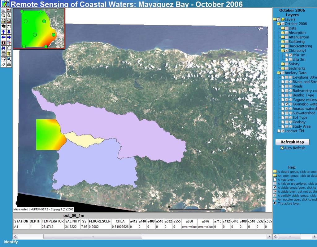
1 NEW WEB TOOL FOR UNDERSTANDING BIOLUMINESCENT BAYS Fernando Gilbes Santaella* and William Hernandez GERS Lab-Department of Geology University of Puerto Rico at Mayaguez


2 RESEARCH COMPONENT OF: Contaminant and Erosion Control Baseline Database for the Puerto Mosquito Watershed in Vieques, Puerto Rico Fernando Gilbes, PI UPRM-Geology Roy Armstrong, Co-PI UPRM-Marine Sciences Sponsored by


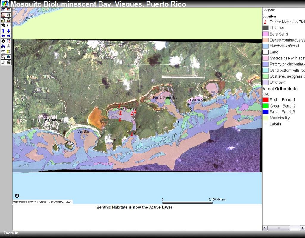
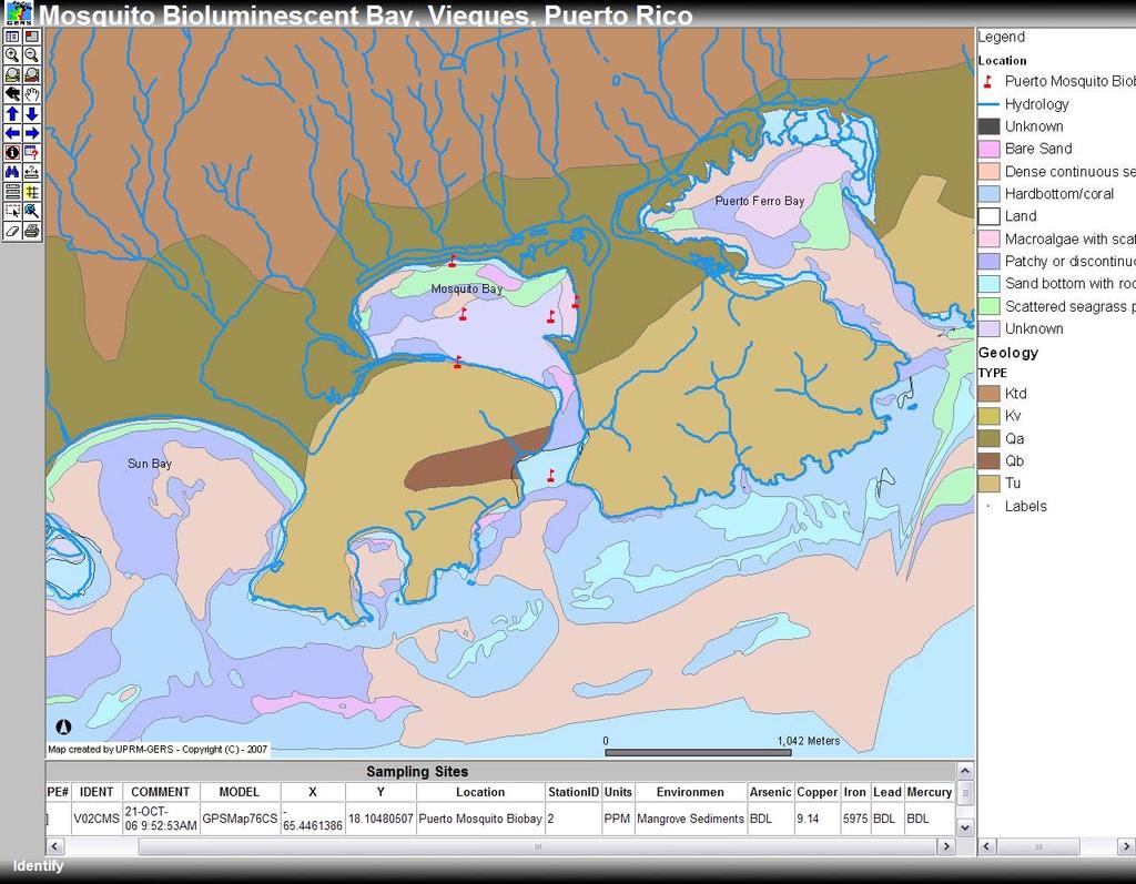
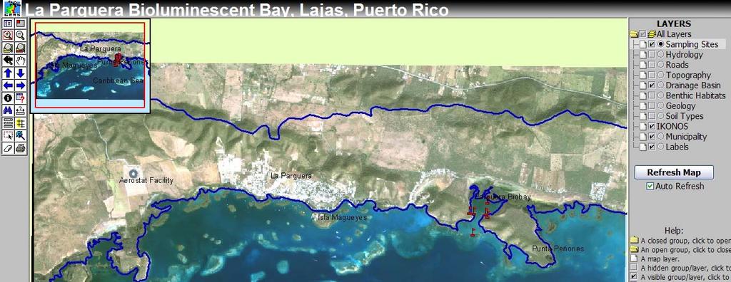
3 Study Sites La Parguera Bay, Lajas Puerto Mosquito, Vieques
4 Objectives of the study Evaluate the impact of sedimentation processes. Evaluate the latest technology in field instruments for measuring bioluminescence. Compare the conditions in Puerto Mosquito Bay and in La Parguera Bay. Develop a database using image processing and GIS and making it available via the internet.


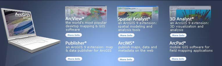

5 ArcGIS 9 Environmental Systems Research Institute, Inc. (ESRI)

 data on the Internet.")

6 ArcIMS ArcIMS 9.1 Scalable Extendable Organizational application Map distribution and geographic information system (GIS) data on the Internet. Create easy-to-use, taskfocused applications that use geographic content. Deliver dynamic maps and data via the Web. Share data with others to accomplish tasks.
7 Configuration at GERS Lab Configure Server Computer Install and Configure Supporting Software (Java 2SDK, Tomcat 5.028, and ISS 6.0) Install ArcIMS 9.1 Create Projects in ArcView Create and Customize ArcIMS Web Application Publish Map Interface in the Web

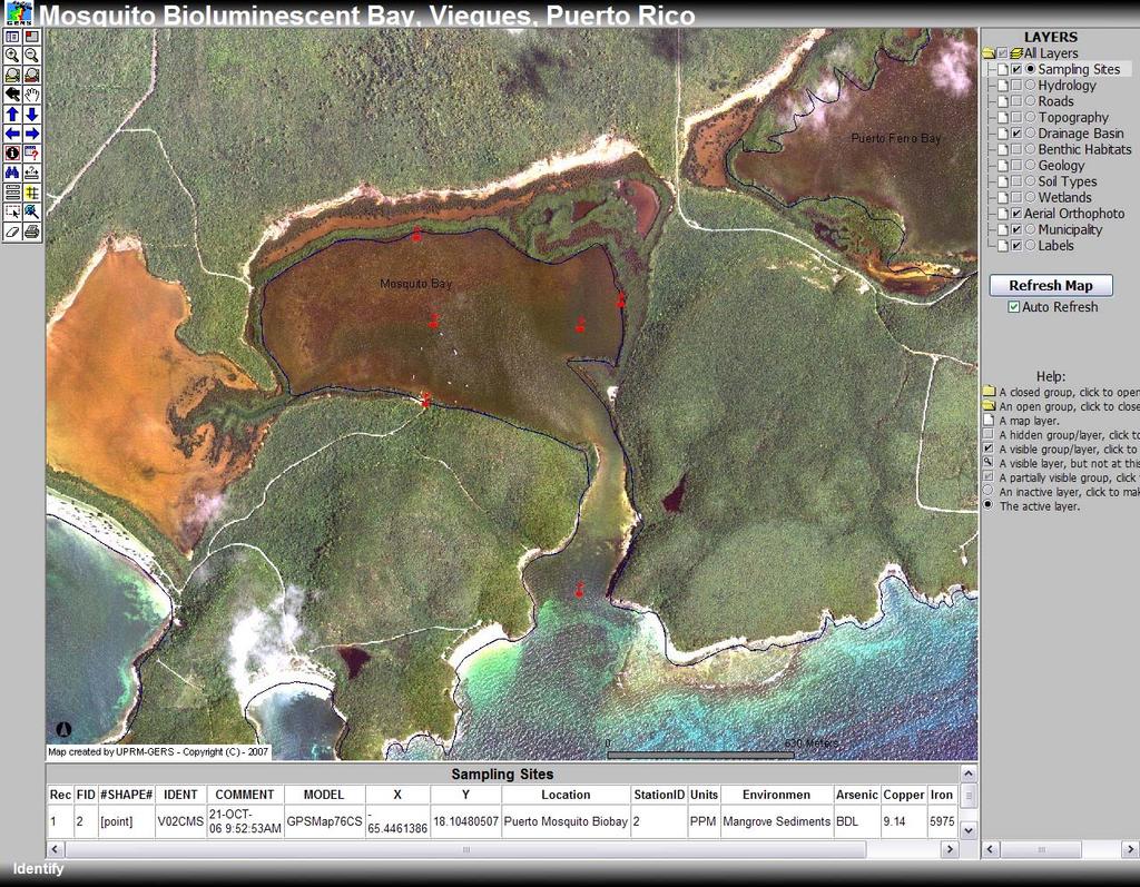
8 Field Data Presence of heavy metals in La Parguera and Puerto Mosquito Bioluminescence Bays. Samples were collected from four different environments: bottom sediments under mangroves mangroves leaves bottom sediments water column
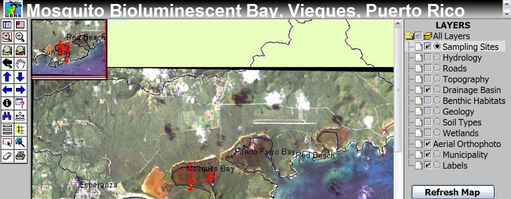
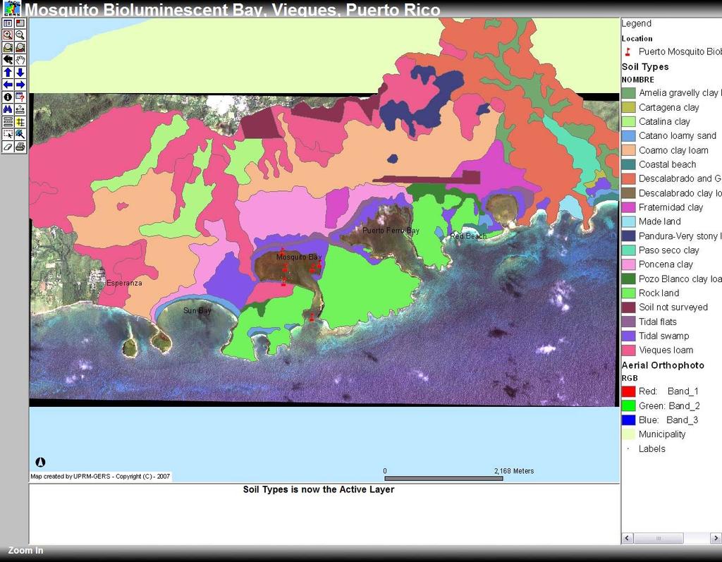
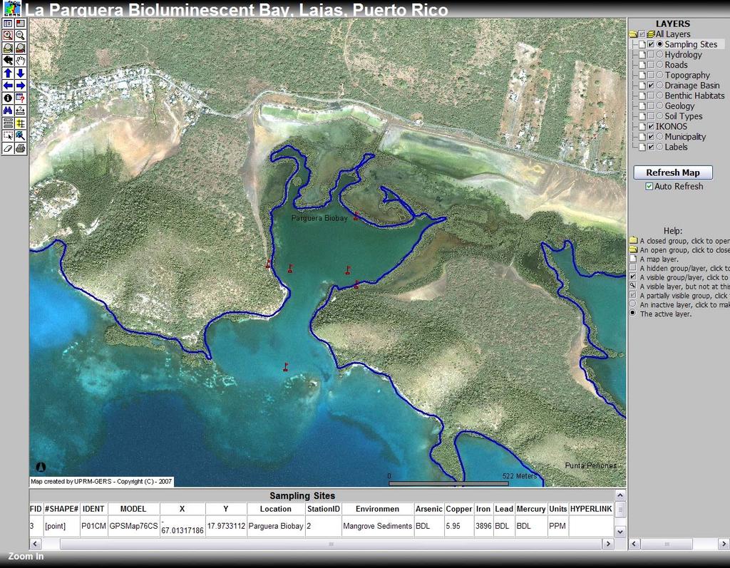
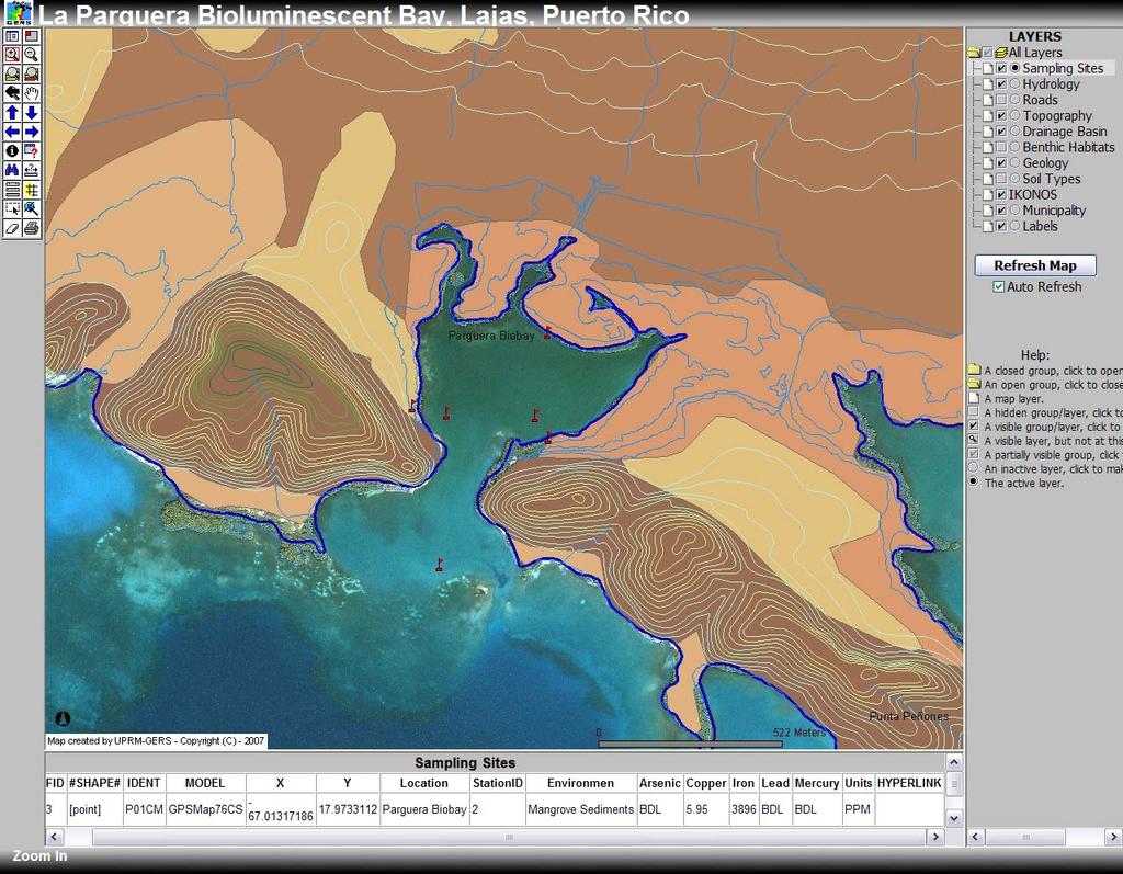
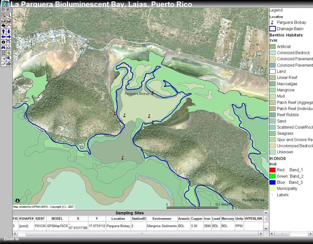
9 Database Table: GIS Data Layers used for Biobays Map Projects Layers Description Source(s) Location Used Sampling Sites From heavy metals study GERS LAB Mosquito Bay, Parguera Bay Hydrology Surface hydrology USGS Mosquito Bay, Parguera Bay Roads Major roads JP, DTOP Mosquito Bay, Parguera Bay Topography Elevation contours USGS Mosquito Bay, Parguera Bay Drainage basin Delimiting drainage basin USGS, JP Mosquito Bay, Parguera Bay Benthic Habitats Benthic community types NOAA Mosquito Bay, Parguera Bay Geology Major geological feaures USGS Mosquito Bay, Parguera Bay Soil Types Soil Types and Series NRCS-USDA Mosquito Bay, Parguera Bay Wetlands Wetland features distribution USFWS Mosquito Bay, Parguera Bay Aerial Orthophotos Aerial Photography (2004) US-COI, NRCS-USDA Mosquito Bay IKONOS image Satellite imagery (2007??) UPRM-GERS Parguera Bay Municipality Puerto Rico Municipality name JP Mosquito Bay, Parguera Bay Labels Important Places UPRM-GERS Mosquito Bay, Parguera Bay Aerial Orthophotos Aerial Photography (1999) NOAA Parguera Bay
10 Web Publishing ArcMap Project (.mxd) ArcIMS Administrator New Service Image Server Arcmap ArcIMS Designer HTML Viewer Customize Viewer Elements Table of contents, tools, layout, etc. HTML Viewer for each site. Mosquito Biobay - Parguera Biobay - Web Page development
11
12
13
14
15
16
17
18
19
20
21
22
23
24
25
26
27
28

29
30


 Central GDB Raster")
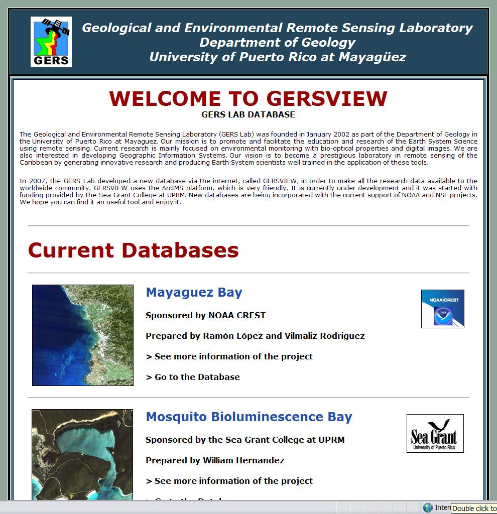
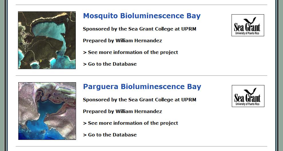
31 GERSVIEW.UPRM.EDU Current Projects Bioluminescence Bays Mayaguez Bay Watershed Future Projects Parguera Reefs GERSVIEW ArcIMS Mapping Interface Mapping Interface (World-Wide Users, Researchers) Central GDB Raster Catalog (Data) ArcView Info Projects


32 Conclusions GIS is an excellent tool for better understanding the dynamics of bioluminescence bays. An important database was accomplished and it is now published in the web for public used. Other databases of coastal environments and marine habitats of PR could be published using a similar system.
33 Next Steps Continue working with Mayaguez Bay database. Start working in a database of Coral Reefs. La Parguera Bio-optical database. Enhance HTML Viewer Hierarchical Table of Contents Hyperlinks, Graphics, etc. Enable Java Viewer Purchase a New Server Better storage and processing Upgrade to ArcIMS 9.3 Include RS imagery analysis products (ENVI, ERDAS).


34 Acknowledgements Sponsored by: Data Sources:


35
Contaminant and Erosion Control Baseline Database for the Puerto Mosquito Watershed In Vieques,, Puerto Rico
 Contaminant and Erosion Control Baseline Database for the Puerto Mosquito Watershed In Vieques,, Puerto Rico Fernando Gilbes, Principal Investigator UPRM-Geology, gilbes@cacique.uprm.edu Roy Armstrong,
Coverage of Mangrove Ecosystem along Three Coastal Zones of Puerto Rico using IKONOS Sensor
 Coverage of Mangrove Ecosystem along Three Coastal Zones of Puerto Rico using IKONOS Sensor Jennifer Toledo Rivera Geology Department, University of Puerto Rico, Mayagüez Campus P.O. Box 9017 Mayagüez,
Water Quality Monitoring and Validation from NOAA operational satellite sensor (VIIRS) Data Products in Coral Reef Environments
 Data Products in Coral Reef Environments") Water Quality Monitoring and Validation from NOAA operational satellite sensor (VIIRS) Data Products in Coral Reef Environments William J Hernandez, Ph.D 1, 4 Post-Doctoral Researcher Roy A. Armstrong
Water Quality Monitoring and Validation from NOAA operational satellite sensor (VIIRS) Data Products in Coral Reef Environments William J Hernandez, Ph.D 1, 4 Post-Doctoral Researcher Roy A. Armstrong
% farmers/private landowners in watershed applying BMPs. Other (Number of participants completed the training)
") Easygrants ID: 23803 National Fish and Wildlife Foundation NFWF/Legacy Grant Project ID: 0302.10.023803 U. S. Coral Reef Task Force Partnership Initiative 2010 - Submit Final Programmatic Report (Activities
Easygrants ID: 23803 National Fish and Wildlife Foundation NFWF/Legacy Grant Project ID: 0302.10.023803 U. S. Coral Reef Task Force Partnership Initiative 2010 - Submit Final Programmatic Report (Activities
Guánica Bay Watershed Initiative
 Guánica Bay Watershed Initiative Prepared by Center for Watershed Protection For NOAA and PRDNER NOAA circulated plan to all agencies USDA/ NRCS entered As commitment to Coral Reef Task Force How did
Paul Sturm Roberto Viqueira Ríos
 Paul Sturm Roberto Viqueira Ríos In this talk Brief Background on Land Based Sources Historical Perspective Guánica watershed characteristics/ issues High priority restoration projects Other key issues
U.S. Activities in Puerto Rico, U.S. Virgin Islands and the Wider Caribbean. NOAA and the US Coral Reef Task Force
 U.S. Activities in Puerto Rico, U.S. Virgin Islands and the Wider Caribbean NOAA and the US Coral Reef Task Force U.S. Coral Reef Task Force Co-Chairs: National Oceanic and Atmospheric Administration (NOAA)
Dimaris Colón Molina. Department of Biology, University of Puerto Rico Mayaguez, P.R
 Shoreline Changes in the West Coast of Puerto Rico as Determined by Remote Sensing Techniques and their Correlation to Changes in the Diversity of Shell-Mollusks Dimaris Colón Molina Department of Biology,
Spatio-temporal Data Analysis and Visualization in Enterprise Level Automated Application
 Spatio-temporal Data Analysis and Visualization in Enterprise Level Automated Application Sept 29 - Oct 1, 2015 Kualal Lumpur Shyam Parhi Washington DC What is driving Airports GIS? Reduce costs to Airports,
Population Composition, Geographic Distribution, and Natural Hazards: Vulnerability in the Coastal Regions of Puerto Rico
 Population Composition, Geographic Distribution, and Natural Hazards: Vulnerability in the Coastal Regions of Puerto Rico Researchers Havidán Rodríguez, Ph.D. (DRC-UDel) Walter Díaz, Ph. D. (CISA-UPRM)
Egnatia Odos Observatory. Egnatia Odos Observatory Monitoring of Egnatia Motorway s s Spatial Impacts
 Egnatia Odos Observatory Egnatia Odos Observatory Monitoring of Egnatia Motorway s s Spatial Impacts 1 Egnatia Odos Observatory 1. The unique Greek observatory of transport and spatial impacts 2. Scope
Federal GIS Conference February 10 11, 2014 Washington DC. ArcGIS for Aviation. David Wickliffe
 Federal GIS Conference 2014 February 10 11, 2014 Washington DC ArcGIS for Aviation David Wickliffe What is ArcGIS for Aviation? Part of a complete system for managing data, products, workflows, and quality
Final Report Sea Grant March 3, A. Executive Summary
 Final Report Sea Grant March 3, 2009 Executive Summary Project Title: Developing a protocol to use remote sensing as a cost effective tool to monitor contamination of mangrove wetlands Date: 3 march 2009
Pantanal Tri-National GIS and Remote Sensing Pilot Project Case Study for Bolivia, Brazil, and Paraguay
 Six Ramsar remote sensing case studies were developed in 2002 as part of the NASA Socioeconomic Data and Application Center's (SEDAC) Ramsar Wetlands Data Gateway, developed in support of the Ramsar Convention
Engineering With Nature Geographic Project Mapping Tool (EWN ProMap)
") Engineering With Nature Geographic Project Mapping Tool (EWN ProMap) Cynthia Banks Program Manager Burton Suedel, PhD Research Biologist Michelle Bourne Research Biologist U.S. Army ERDC 23 June 2015 Dredging
Engineering With Nature Geographic Project Mapping Tool (EWN ProMap) Cynthia Banks Program Manager Burton Suedel, PhD Research Biologist Michelle Bourne Research Biologist U.S. Army ERDC 23 June 2015 Dredging
Note that the steepest 8 direction pour point model slope in direction 64 is: 10.0
 GIS in Water Resources Exercise #3 Solution Part 1. 1.1 Hand Calculations (i) The standard ESRI surface slope function Grid size 10 m Diagonal distance= 14.142 m 47.5 48 47.7 50.6 48.3 dz/dx= -0.125 45.1
Abstract. Introduction
 Motorway Management With GIS: The Example of Attiki Odos Dr. Eng. Thanos E. Doganis Terra Ltd. Bill M. Chalkias Msc CEO of Attikes Diadromes S.A. Georgia Gania GIS Specialist Attikes Diadromes S.A. Abstract
Melinda McCoy, CDM Project Manager Jonathan Posner, CDM Steven Wolosoff, CDM Don Schroeder, CDM
 A Task 8-1 GIS List of Lands for BMPs for North Santa Monica Bay Regional Watershed Implementation Plan and Malibu Creek Watershed Bacteria TMDL Implementation Plan To: From: Carolina Hernandez, of Watershed
An Overview of the Puerto Rico Technology Transfer Center: A Local Technical Assistance Program Component
 Second LACCEI International Latin American and Caribbean Conference for Engineering and Technology (LACCEI 2004) Challenge and Opportunities for Engineering Education, Research and Development 2-4 June
MIDDLE SCHOOL CURRICULUM TR AILING ICE AGE M YST ERI E S SEARCHING GLACIAL FEATURES
 MIDDLE SCHOOL CURRICULUM TR AILING ICE AGE M YST ERI E S SEARCHING GLACIAL FEATURES CONTENTS I. Enduring Knowledge... 3 II. Teacher Background... 3 III. Before Viewing the Video... 5 IV. Viewing Guide...
PANTANAL TRI-NATIONAL GIS AND REMOTE SENSING PILOT PROJECT CASE STUDY FOR BOLIVIA, BRAZIL, AND PARAGUAY
 PANTANAL TRI-NATIONAL GIS AND REMOTE SENSING PILOT PROJECT CASE STUDY FOR BOLIVIA, BRAZIL, AND PARAGUAY KISTINE KUHLMAN 1 DAWN BROWNE 2 MONTSERRAT CARBONELL 2 CARLOS ROBERTO PADOVANI 3 1 Ph.D. Candidate,
3-D GIS Applications in Aviation and Aerospace Pedagogy Dr. Rich Snow, Dr. Mary Snow, and Mario Westphal. Abstract
 3-D GIS Applications in Aviation and Aerospace Pedagogy Dr. Rich Snow, Dr. Mary Snow, and Mario Westphal Abstract Embry-Riddle Aeronautical University s new GIS Applications Lab has developed a 3-D airspace
The Applications of GIS and Remote Sensing Technology For Development and Decision Making in Ecotourism
 NRS 509 - Concepts in GIS and Remote Sensing FINAL PROJECT BY: MOCHAMMAD R. PRAYOGA The Applications of GIS and Remote Sensing Technology For Development and Decision Making in Ecotourism INTRODUCTION
FAA Airports GIS Program
 FAA Airports GIS Program Environmental Feature Classes for Airport Noise Michael T. McNerney, Ph.D., P.E. Office of Airports Airport Safety and Standards Airport Engineering Division Mike.mcnerney@faa.gov
Provincial Land and Resource Management Initiative
 Provincial Land and Resource Management Initiative Esri Canada User Conference November 6, 2013 Gretchen Pohlkamp, Executive Director Land Services Department of Natural Resources The Problem Like most
INTERNATIONAL CIVIL AVIATION ORGANIZATION AFI REGION AIM IMPLEMENTATION TASK FORCE. (Dakar, Senegal, 20 22nd July 2011)
") IP-5 INTERNATIONAL CIVIL AVIATION ORGANIZATION AFI REGION AIM IMPLEMENTATION TASK FORCE (Dakar, Senegal, 20 22nd July 2011) Agenda item: Presented by: Implementation of a African Regional Centralised Aeronautical
IP-5 INTERNATIONAL CIVIL AVIATION ORGANIZATION AFI REGION AIM IMPLEMENTATION TASK FORCE (Dakar, Senegal, 20 22nd July 2011) Agenda item: Presented by: Implementation of a African Regional Centralised Aeronautical
agis a brief overview
 agis a brief overview Steve Welebny Photogrammetrist Keystone Aerial Surveys Villanova University 1 Villanova University 2 Nav Aid Cost VOR Install = $250,000 20 year life cycle cost = $1,100,000 ILS Install
FERNANDO GILBES-SANTAELLA DEPARTMENT OF GEOLOGY UNIVERSITY OF PUERTO RICO AT MAYAGÜEZ MAYAGÜEZ, PUERTO RICO
 FERNANDO GILBES-SANTAELLA DEPARTMENT OF GEOLOGY UNIVERSITY OF PUERTO RICO AT MAYAGÜEZ MAYAGÜEZ, PUERTO RICO 00681-9000 PHONE: (787) 832-4040 Ext. 3000 FAX: (787) 265-3845 EMAIL: fernando.gilbes@upr.edu
ICTAP Program. Interoperable Communications Technical Assistance Program. Communication Assets Survey and Mapping (CASM) Tool Short Introduction
 Tool Short Introduction") ICTAP Program Interoperable Communications Technical Assistance Program Communication Assets Survey and Mapping (CASM) Tool Short Introduction Outline Overview General Information Purpose Security Usage
ICTAP Program Interoperable Communications Technical Assistance Program Communication Assets Survey and Mapping (CASM) Tool Short Introduction Outline Overview General Information Purpose Security Usage
Guánica Bay Watershed
 P A R T N E R S H I P F O R T H E GUÁ N I C A B A Y W A T E R S H E D October 15, 2010 Volume 1, Issue 1 Guánica Bay Watershed update Inside this issue: NFWF Grants 2 Personnel Updates 3 Webinar 4 Community
Waukegan & Calumet Rivers. All Hands Meeting
 Waukegan & Calumet Rivers 516(e) Update All Hands Meeting David F. Bucaro, P.E. Chief, Economic Formulation & Analysis Section, Planning Branch May 18 th, 2011 Kensington Court Ann Arbor, MI 1 2 Waukegan
Active Geodetic Network of Serbia
 Active Geodetic Network of Serbia Oleg ODALOVIC and Ivan ALEKSIC, Serbia Key words: GPS, AGROS, RINEX, RTCM SUMMARY In June 2003 the Republic Geodetic Authority (RGZ) has started the realization of the
U.S. Department of the Interior Office of Inspector General
 z U.S. Department of the Interior Office of Inspector General Aviation Maintenance Tracking and Pilot Inspector Practices Further Advances Needed Report No. WR-EV-OSS-0005-2009 April 2009 Cover Graphics:
Census 2010 Map Book Genoa Township
 Census Map Book Sources: Esri, DeLorme, NAVTEQ, TomTom, Intermap, AND, USGS, NRCAN, Kadaster NL, IGN, and the GIS User Community. About this map book SEMCOG Community Map Books provide easy to understand,
MEETING CONCLUSIONS. Andean South America Regional Meeting Lima, Peru 5-7 March ECOTOURISM PLANNING
 MEETING CONCLUSIONS Andean South America Regional Meeting Lima, Peru 5-7 March 2002 1.0 ECOTOURISM PLANNING 1.1 Protected Areas Ecotourism in Protected Areas is part of an integrated vision of tourism
AIXM Annual Conference 2008 Day 2 March 19 th (morning) Migration TO and FROM AIXM from other AMDB Formats. Alan Poole/Dejan Damjanovic
 Migration TO and FROM AIXM from other AMDB Formats. Alan Poole/Dejan Damjanovic") AIXM Annual Conference 2008 Day 2 March 19 th (morning) Migration TO and FROM AIXM from other AMDB Formats Alan Poole/Dejan Damjanovic Overview Background and Problem Definitions. IATA AIS Data Pool Vision.
AIXM Annual Conference 2008 Day 2 March 19 th (morning) Migration TO and FROM AIXM from other AMDB Formats Alan Poole/Dejan Damjanovic Overview Background and Problem Definitions. IATA AIS Data Pool Vision.
Arizona National Scenic Trail
 1 The Arizona National Scenic Trail is an 800 mile recreation trail from Mexico to Utah that connects mountain ranges, canyons, deserts, forests, wilderness areas, historic sites, trail systems, points
RISING PERFORMANCE. Civil aviation is an outlier. It s BY ERIK DAHLBERG
 RISING PERFORMANCE Compact mobile mapping systems can be installed on small passenger cars. Civil aviation is an outlier. It s among the few industries where tight government regulations are widely accepted
Washington Dulles International Airport (IAD) Aircraft Noise Contour Map Update. 6th Working Group Briefing 1/7/19
 Aircraft Noise Contour Map Update. 6th Working Group Briefing 1/7/19") Washington Dulles International Airport (IAD) Aircraft Noise Contour Map Update 6th Working Group Briefing 1/7/19 Study Purpose Agenda Background Summary of last stakeholder meetings Refresher on DNL,
Washington Dulles International Airport (IAD) Aircraft Noise Contour Map Update 6th Working Group Briefing 1/7/19 Study Purpose Agenda Background Summary of last stakeholder meetings Refresher on DNL,
NGAP / TRAINAIR PLUS Regional Conference The Americas. Training Challenges for New Generation Aircraft
 NGAP / TRAINAIR PLUS Regional Conference The Americas Training Challenges for New Generation Aircraft NGAP / TRAINAIR PLUS Regional Conference The Americas Presented by: Frank L. Johnson Manager Maintenance
2011 Nags Head Beach Nourishment Project Update. Tim Kana & Haiqing Kaczkowski
 2011 Nags Head Beach Nourishment Project Update Tim Kana & Haiqing Kaczkowski NCBIWA Conference 3 April 2017 Outline of the Presentation 1 Review 2011 Nourishment Project Post-project monitoring efforts
Analysis and design of road and bridge infrastructure database using online system
 Analysis and design of road and bridge infrastructure database using online system Joni Arliansyah 1,*, Yadi Utama 2, Maureen Arlini Wijayanti 3, Rachmat Gusti 3,and Arifianto 3 1 Department of Civil Engineering
Integration Of Reflectance To Study Glacier Surface Using Landsat 7 ETM+: A Case Study Of The Petermann Glacier In Greenland
 Integration Of Reflectance To Study Glacier Surface Using Landsat 7 ETM+: A Case Study Of The Petermann Glacier In Greenland Félix O. Rivera Santiago Department Of Geology, University Of Puerto Rico, Mayaguez
A Conceptual Framework for Measuring the Exposure to Tsunamis of Puerto Rican Coastal Communities
 Meulaboh, Aceh A Conceptual Framework for Measuring the Exposure to Tsunamis of Puerto Rican Coastal Communities Jean-Edouard Faucher Saylisse Dávila, PhD Department of Industrial Engineering University
2010 International Snow Science Workshop
 USING GIS AND GOOGLE EARTH FOR THE CREATION OF THE GOING-TO-THE-SUN ROAD AVALANCHE ATLAS, GLACIER NATIONAL PARK, MONTANA, USA Erich H. Peitzsch 1*, Daniel B. Fagre 1, Mark Dundas 2 1 U.S. Geological Survey,
ESASky: A New Window to the Universe
 ESASky: A New Window to the Universe María Sarmiento on behalf of ESDC team 16/06/2016 Issue/Revision: 1.0 Reference: ASTERICS June 2016, Heidelberg Status: Issued ESASky Concept Interface to all astronomy
EXECUTIVE SUMMARY COMMONWEALTH OF PUERTO RICO FY 2004-FY2009 MAP MODERNIZATION BUSINESS PLAN. Page i
 EXECUTIVE SUMMARY I. Introduction The Commonwealth of Puerto Rico will support the Federal Emergency Management Agency s (FEMA s) Multi-Hazard Flood Map Modernization Program (MHFMMP) by contributing to
ICRI Monaco January 2010
 Economic Valuation of Coral Reefs in the Caribbean ICRI Monaco January 2010 Lauretta Burke World Resources Institute (WRI) Beautiful Valuable Valuable Valuable Valuable Valuable Photos: Krishna Desai Valuable
Curriculum Vitae (C.V.) Ahmed Abdel-Halim Ahmed Mohamed
 Ahmed Abdel-Halim Ahmed Mohamed") Permanent Address Department of Geology, Faculty of Science, Assiut University, Assiut 71516, Egypt Tel: 0020 88 2 41 21 89 Fax: 0020 88 2 342 708 Cell: 0020 10 83 90 135 ahmed41982@yahoo.com Personal
Permanent Address Department of Geology, Faculty of Science, Assiut University, Assiut 71516, Egypt Tel: 0020 88 2 41 21 89 Fax: 0020 88 2 342 708 Cell: 0020 10 83 90 135 ahmed41982@yahoo.com Personal
Budi Hadi Narendra Harris Herman Siringoringo Chairil Anwar Siregar. Research and Development Center for Forest
 Budi Hadi Narendra Harris Herman Siringoringo Chairil Anwar Siregar Research and Development Center for Forest Background Coastal management should be wisely done as a part of watershed management. Typologically,
Chapter 4.0 Alternatives Analysis
 Chapter 4.0 Alternatives Analysis Chapter 1 accumulated the baseline of existing airport data, Chapter 2 presented the outlook for the future in terms of operational activity, Chapter 3 defined the facilities
Simple practices to improve and optimize on site wastewater disposal systems (OSDS) in Special Communities of Río Grande de Añasco Watershed
 in Special Communities of Río Grande de Añasco Watershed") Simple practices to improve and optimize on site wastewater disposal systems (OSDS) in Special Communities of Río Grande de Añasco Watershed UNIVERSITY OF PUERTO RICO Mayagüez Campus Ana Navarro, Sea Grant
Simple practices to improve and optimize on site wastewater disposal systems (OSDS) in Special Communities of Río Grande de Añasco Watershed UNIVERSITY OF PUERTO RICO Mayagüez Campus Ana Navarro, Sea Grant
Platform and Products
 International Partnership Space Programme Earth Observation for the Preservation of Ecological Bacalar Corridor Platform and Products Terri Freemantle, Raffaella Guida, Paula Marti, Pasquale Iervolino
Preliminary Site Evaluation
 Preliminary Site Evaluation 100 Acre Site, US 72 Piperton, Tennessee Power Distributor: Chickasaw Electric Cooperative August 2010 SITE DATA SHEET PIPERTON US 72 SITE (100 ACRES): LOCATION & GENERAL DESCRIPTION
FOR SMALL AND MEDIUM SIZED AIRPORTS Velocity FIDS
 is a FIDS solution for small and medium sized airports. It is available as an installed and as a cloud solution and it is multi airport solution. The package contains many use full features like a flight
AUGUST 2017 GNSS REVIEW. Survey Economics Chances of success. Mobile Mapping Airport scanning. Stag s Leap Winery Pre-construction plan
 AUGUST 2017 GNSS REVIEW Survey Economics Chances of success Stag s Leap Winery Pre-construction plan Mobile Mapping Airport scanning RISING PERFORMANCE» ERIK DAHLBERG Civil aviation is an outlier. It s
PUERTO RICO. Puerto Rico S Coral Reef Management Priorities PUERTO RICO S CORAL REEF MANAGEMENT PRIORITIES
 PUERTO RICO PUERTO RICO S CORAL REEF MANAGEMENT PRIORITIES Puerto Rico S Coral Reef Management Priorities I PUERTO RICO S CORAL REEF MANAGEMENT PRIORITIES The Commonwealth of Puerto Rico and NOAA Coral
HYDROLOGY OF GLACIAL LAKES, FORT SISSETON AREA
 PROC. S.D. ACAD. SCI., VOL. 77 (1998) 59 HYDROLOGY OF GLACIAL LAKES, FORT SISSETON AREA Perry H. Rahn Department of Geology & Geological Engineering South Dakota School of Mines and Technology Rapid City,
Estuaries of South America
 Gerardo M.E. Perillo Maria Cintia Piccolo Mario Pino-Quivira (Eds.) Estuaries of South America Their Geomorphology and Dynamics With 102 Figures and 20 Tables Springer 1 What Do We Know About the Geomorphology
Land Figures & Spatial Data Infrastructure in KOSOVO
 Land Figures & Spatial Data Infrastructure in KOSOVO Idriz SHALA idriz.shala@gmail.com GIS -expert Afrim SHARKU afrim.sharku@gmail.com Land Management - Expert Kick-off meeting of the Regional Expert Advisory
EO-based services to support humanitarian operations: monitoring population and natural resources in refugee/idp camps
 How satellites can help to save lives Vienna, Austria 23 February 2016 EO-based services to support humanitarian operations: monitoring population and natural resources in refugee/idp camps Petra FÜREDER
Monitoring & Control Tim Stevenson Yogesh Wadadekar
 Monitoring & Control Tim Stevenson Yogesh Wadadekar Monitoring & Control M&C is not recognised as an SPDO Domain However the volume of work carried out in 2011 justifies a Concept Design Review M&C is
MEMORANDUM. Honorable Mayor and City Councilmembers William S. Joynes, Sr., City Administrator
 AGENDA ITEM 1A MEMORANDUM DATE: January 17, 2017 TO: FROM: SUBJECT: Honorable Mayor and City Councilmembers William S. Joynes, Sr., City Administrator Sue Polka, Interim Asst. Public Works Director/City
Bradley Brook Relocation Project. Scoping Notice. Saco Ranger District. United States Department of Agriculture Forest Service
 Bradley Brook Relocation Project United States Department of Agriculture Forest Service Scoping Notice White Mountain National Forest February 2011 For Information Contact: Jenny Burnett White Mountain
ReefFix. May, For the Organization of American States (OAS) and the Inter-American Biodiversity Information Network (IABIN)
 and the Inter-American Biodiversity Information Network (IABIN)") Fondation pour la Protection de la Biodiversité Marine FoProBiM B.P. 642 www.foprobim.org (mail) 6011 Henning St. Port-au-Prince, Haiti Bethesda, MD 20817 ReefFix Rapid Assessment of the Economic Value
Fondation pour la Protection de la Biodiversité Marine FoProBiM B.P. 642 www.foprobim.org (mail) 6011 Henning St. Port-au-Prince, Haiti Bethesda, MD 20817 ReefFix Rapid Assessment of the Economic Value
LITTLE LOST MAN CREEK (LLM) (formerly USGS Gaging Station No )
 (formerly USGS Gaging Station No )") LITTLE LOST MAN CREEK (LLM) (formerly USGS Gaging Station No. 11482468) LOCATION: In Redwood National and State Park approximately 0.8 miles upstream from confluence with Prairie Creek and 3.2 miles northeast
LITTLE LOST MAN CREEK (LLM) (formerly USGS Gaging Station No. 11482468) LOCATION: In Redwood National and State Park approximately 0.8 miles upstream from confluence with Prairie Creek and 3.2 miles northeast
MARINA BOLADO PENAGOS A METHODOLOGY TO ASSESS THE ROLE OF THE RIVER DISCHARGES TO THE GULF OF CADIZ ON THE NUTRIENT SUPPLY TO THE ALBORAN SEA
 MARINA BOLADO PENAGOS A METHODOLOGY TO ASSESS THE ROLE OF THE RIVER DISCHARGES TO THE GULF OF CADIZ ON THE NUTRIENT SUPPLY TO THE ALBORAN SEA INTRODUCTION General MEGAN Project Case Study Guadalquivir
Optimizing trajectories over the 4DWeatherCube
 Optimizing trajectories over the 4DWeatherCube Detailed Proposal - SES Awards 2016 Airbus Defence and Space : dirk.schindler@airbus.com Luciad : robin.houtmeyers@luciad.com Eumetnet : kamel.rebai@meteo.fr
Coral Reefs: Integrative Teaching Tool (and Guide to NOAA Resources) National Science Teachers Association April 6, 2006 Anaheim, California
 National Science Teachers Association April 6, 2006 Anaheim, California") Coral Reefs: Integrative Teaching Tool (and Guide to NOAA Resources) National Science Teachers Association April 6, 2006 Anaheim, California NOAA Coral Reef Conservation Program: Created by NOAA in 2000
Coral Reefs: Integrative Teaching Tool (and Guide to NOAA Resources) National Science Teachers Association April 6, 2006 Anaheim, California NOAA Coral Reef Conservation Program: Created by NOAA in 2000
ROAD AND TRAIL PROJECT APPROVAL
 ROAD AND TRAIL PROJECT APPROVAL www.marincountyparks.org Marin County Parks, 3501 Civic Center Dr, Suite 260, San Rafael, CA 94903 DATE: July 12, 2017 PRESERVE: Gary Giacomini Open Space Preserve PROJECT:
An On Demand Hotel Information System
 An On Demand Hotel Information System An on-line hotel management system that increases the profitability of your hotel business by centralizing your propertie' s operations and providing real time information
Microsoft Courses Schedule February December 2017
 Training Solutions guarantee. An established hi-tech certified training Microsoft Courses Schedule February December 2017 20345-1 Administering Microsoft Exchange Server 2016 990 13 March 17 March........
Chapter Seven REFERENCES
 Chapter Seven REFERENCES Chapter Seven REFERENCES Barhydt, Barbara, Development Review Services Manager, City of Portland 2018. Email communication with Dwight Anderson, Stantec Consulting Services (Stantec),
15th Edition From Dec. 5, 2011 to Feb. 27, 2012 Minor update to reflect the domain change. Changed and weblinks to svsarana.
 20th Edition Sept. 25, 2015 to Apr. 10, 2018 Yes we still update these guides. Updated minor general information, links, currency rates, etc. Changed waypoints for Barillas due to changes in the bar from
PARAMOUNT A Local Based Service (LBS) Prototype for Mountaineers and Rescuers
 Prototype for Mountaineers and Rescuers") PARAMOUNT A Local Based Service (LBS) Prototype for Mountaineers and Rescuers Nik Klever, Bergwacht Bayern (www.bergwacht-bayern,de) Gebhard Barbisch, Österreichischer Bergrettungsdienst (www.bergrettung.at)
PARAMOUNT A Local Based Service (LBS) Prototype for Mountaineers and Rescuers Nik Klever, Bergwacht Bayern (www.bergwacht-bayern,de) Gebhard Barbisch, Österreichischer Bergrettungsdienst (www.bergrettung.at)
Incorporates passenger management, fleet management and revenue/cost reporting
 1 Web based business system providing comprehensive functionality for domestic and international airline operations Incorporates passenger management, fleet management and revenue/cost reporting Comprehensive
An Introduction. The Saginaw River/Bay Area of Concern
 Saginaw River & Bay Area of Concern: Looking Forward Continued Partnerships in the Restoration of Saginaw Bay Michelle Selzer Lake Huron Coordinator & Interim AOC Coordinator Saginaw Bay Watershed Conference
Saturday March 8, :40 AM to 12:00 or Saturday April 12, :40 to 5:00 PM
 General Oceanography Geology 105 Discovery Voyage on San Francisco Bay Saturday March 8, 2014 7:40 AM to 12:00 or Saturday April 12, 2014 12:40 to 5:00 PM Students will participate as scientists on a 4-hour
Oak Ridges Moraine: Southern Ontario's Sponge
 Oak Ridges Moraine: Southern Ontario's Sponge Lesson Overview Students will examine the location and the importance of the Oak Ridges Moraine and investigate ongoing conflicts concerning its development.
UAS to GIS Utilizing a low-cost Unmanned Aerial System (UAS) for Coastal Erosion Monitoring
 for Coastal Erosion Monitoring") UAS to GIS Utilizing a low-cost Unmanned Aerial System (UAS) for Coastal Erosion Monitoring Agenda Scope of today s presentation Demonstration Objectives Wrightsville Beach Test Area Masonboro Inlet Jetties
UAS to GIS Utilizing a low-cost Unmanned Aerial System (UAS) for Coastal Erosion Monitoring Agenda Scope of today s presentation Demonstration Objectives Wrightsville Beach Test Area Masonboro Inlet Jetties
Memorandum. Conclusions
 Memorandum To: Jeff Oliver, City of Golden Valley From: Greg Wilson, Barr Engineering Co. Subject: Follow-up on Phase 1 of Twin Lake Alum Treatment and Recommendations for Phase 2 Date: June 13, 2018 Project:
In-Service Data Program Helps Boeing Design, Build, and Support Airplanes
 In-Service Data Program Helps Boeing Design, Build, and Support Airplanes By John Kneuer Team Leader, In-Service Data Program The Boeing In-Service Data Program (ISDP) allows airlines and suppliers to
5. Identifying the needs, wants, and desires of trail users. 8. Determining the type of trail system and level of difficulty
 Contents Chapter 1: Planning...1 The Planning Process...1 Step 1: Determining Consistency with State, Regional, County, & Local Planning Efforts... 2 Step 2: Selecting a Trail Designer... 2 Step 3: Engaging
Aquatic insect surveys at Mount Magazine State Park and Hobbs State Park Conservation Area with implementation of an educational component
 Aquatic insect surveys at Mount Magazine State Park and Hobbs State Park Conservation Area with implementation of an educational component Arkansas is home to a relatively large number of endemic invertebrates
OBSTACLE IDENTIFICATION SURFACE CALCULATION TOOL (OIS CT) FOR AIRPORT AIRSPACE OBSTRUCTION ANALYSES AT CIVIL AIRPORTS IN THE UNITED STATES
 FOR AIRPORT AIRSPACE OBSTRUCTION ANALYSES AT CIVIL AIRPORTS IN THE UNITED STATES") OBSTACLEIDENTIFICATIONSURFACECALCULATIONTOOL(OISCT) FORAIRPORTAIRSPACEOBSTRUCTIONANALYSESATCIVILAIRPORTS INTHEUNITEDSTATES ApostolPanayotov,PhD,Mr.MarkGibbs,M.S.A,A.A.E,Mr.BradKetel IntroductiontotheObstacleIdentificationSurfaceAnalyses
OBSTACLEIDENTIFICATIONSURFACECALCULATIONTOOL(OISCT) FORAIRPORTAIRSPACEOBSTRUCTIONANALYSESATCIVILAIRPORTS INTHEUNITEDSTATES ApostolPanayotov,PhD,Mr.MarkGibbs,M.S.A,A.A.E,Mr.BradKetel IntroductiontotheObstacleIdentificationSurfaceAnalyses
ERIE INTERNATIONAL AIRPORT MASTER PLAN TABLE OF CONTENTS
 EXECUTIVE SUMMARY ERIE INTERNATIONAL AIRPORT MASTER PLAN TABLE OF CONTENTS PAGE NO. CHAPTER 1-INTRODUCTION... 1-1 1.01 General...1-1 1.02 Purpose and Scope of Study...1-1 1.03 The Planning Process...1-2
Lidar Imagery Reveals Maine's Land Surface in Unprecedented Detail
 Maine Geologic Facts and Localities December, 2011 Lidar Imagery Reveals Maine's Land Surface in Unprecedented Detail Text by Woodrow Thompson, Department of Agriculture, Conservation & Forestry 1 Introduction
Ocho Rios, Jamaica GEF-IWCAM AND IABIN INDICATORS MECHANISM WORKSHOP March TNC s Marine Protected Area Work.
 TNC s Marine Protected Area Work in the Caribbean GEF-IWCAM AND IABIN INDICATORS MECHANISM WORKSHOP 10-12 March 2008 Ocho Rios, Jamaica Caribbean Decision-Support System 3 years (2003-2006) $2.2 million
USDA Trails Strategy WRI: ENGLISH PEAK SURVEY. Theodore Mendoza San Diego State University June 6 th 2016 August 18 th Advisor: Sam Commarto
 WRI: ENGLISH PEAK SURVEY Theodore Mendoza San Diego State University June 6 th 2016 August 18 th 2016 Advisor: Sam Commarto Klamath National Forest Submitted: March 21, 2017 Table of Contents Acknowledgements
I-3 DFW Extension Public Hearing. June 2, 2011
 1 I-3 DFW Extension Public Hearing June 2, 2011 2 DFW LRT Extension Agenda: Introductions Service Plan Amendment Alignment, Grade Separations, Station, Yard Environmental Assessment Environmental Impacts/Mitigation
Appendix A. PHYSICAL, SOCIAL, AND ECONOMIC STATISTICS
 Appendix A. PHYSICAL, SOCIAL, AND ECONOMIC STATISTICS FOR THE CARIBBEAN REGION TABLE A1. CORAL REEF AREA IN THE WIDER CARIBBEAN Estimates of Coral Reef Area Reefs at Risk in the World Atlas of Coral Reefs
USDA TRAILS STRATEGY PROGRAM
 USDA TRAILS STRATEGY PROGRAM WRPI Program: English Peak Survey Jorge D. Briceño Southwestern Community College Internship Time Period: June 6, 2016 August 8, 2016 Advisor: Sam Commarto Recreation Officer
Unmanned Aircraft Systems (UAS) at the Jornada Experimental Range
 at the Jornada Experimental Range") Unmanned Aircraft Systems (UAS) at the Jornada Experimental Range Al Rango and the Jornada UAS Flight Team: Connie Maxwell, Amy Slaughter, Andrea Laliberte, Chris Pierce, Dave Thatcher, Jim Lenz, and Craig
Unmanned Aircraft Systems (UAS) at the Jornada Experimental Range Al Rango and the Jornada UAS Flight Team: Connie Maxwell, Amy Slaughter, Andrea Laliberte, Chris Pierce, Dave Thatcher, Jim Lenz, and Craig
ENHANCEMENT OF THE FAA s ON-LINE WILDLIFE AIRCRAFT STRIKE DATABASE WITH AN INTERACTIVE GRAPHICS CAPABILITY
 University of Nebraska - Lincoln DigitalCommons@University of Nebraska - Lincoln 2005 Bird Strike Committee-USA/Canada 7th Annual Meeting, Vancouver, BC Bird Strike Committee Proceedings August 2005 ENHANCEMENT
A428 Cambourne to Cambridge Better Bus Journeys. Landscape & Planning Appraisal Study Area. Key. Study Area. Westwick. Oakington.
 Westwick Boxworth Lower Gate Caldecote Highfields Cambridge Crow End Croft Newtown Roman Hill Harlton Source: Esri, DigitalGlobe, GeoEye, Earthstar Haslingfield Geographics, CNES/Airbus DS, USDA, USGS,
Trail Assessment Report
 Trail Assessment Report Trail Options for the Bear Creek Canyon located in Pikes Peak Ranger District, Pike National Forest and on Colorado Springs Utility Lands Due to the presence of a unique species
Alpinists and the future Swiss topographic landscape model
 Bundesamt für Landestopographie Office fédéral de topographie Seftigenstrasse 264 CH-3084 Wabern Ufficio federale di topografia Telephone +41 31 963 21 11 Federal Office of Topography Fax +41 31 963 24
Puerto Rico in the Aftermath of Hurricanes Irma and Maria Jason Bram, Officer Research Economist
 Puerto Rico in the Aftermath of Hurricanes Irma and Maria Jason Bram, Officer Research Economist March 7, 2018 The views expressed here are those of the presenter and do not necessarily represent those
Airport Master Plan Update
 Duttchessss Countty Airrporrtt Masstterr Plan Updatte Airport Master Plan Update Final Report Dutchess County Airport Town of Wappingers, New York C&S Engineers, Inc. 499 Col. Eileen Collins Blvd. Syracuse,
FAA Update. Dakota-Minnesota (DMA) Airports District Office. Federal Aviation Administration. Presented to: By: Date: South Dakota Airports Conference
 Airports District Office. Federal Aviation Administration. Presented to: By: Date: South Dakota Airports Conference") FAA Update Dakota-Minnesota (DMA) Airports District Office Presented to: By: Date: South Dakota Airports Conference Chris Hugunin & Dave Anderson March 18, 2015 FY 2014 DMA ADO Total AIP Funding $107.2
FAA Update Dakota-Minnesota (DMA) Airports District Office Presented to: By: Date: South Dakota Airports Conference Chris Hugunin & Dave Anderson March 18, 2015 FY 2014 DMA ADO Total AIP Funding $107.2