USE OF 3D GIS IN ANALYSIS OF AIRSPACE OBSTRUCTIONS
|
|
|
- Joanna Campbell
- 5 years ago
- Views:
Transcription
1 USE OF 3D GIS IN ANALYSIS OF AIRSPACE OBSTRUCTIONS A project by by Samuka D. W. F19/1461/2010 Supervisor; Dr D. N. Siriba 1
2 Background and Problem Statement The Airports in Kenya are the main link between Kenya and the rest of the world. The economy of Kenya is highly dependent on the Airports functioning properly and effectively. Airport safety and security comes out as one of the majorly unadhered to areas of regulations for African airports. Private developers and contractors in the neighborhoods of airports do not take into consideration these standards before erecting buildings that end up being obstruction to the navigable airspace as evidenced by demolitions rampart around the airports in kenya. 2
3 Airspace around the airport needs to be clear for safe take-off and landing of aircrafts. International and local regulations have been established to keep the airports secure. The International Civil Aviation Organization (ICAO), Kenya Airports Authority (KAA) and Kenya Civil Aviation Authority (KCAA) have laid out procedures and standards that are necessary in keeping the Airport airspace open enough to allow safe navigation into and out of the airport. 3
4 The Problem Statement; Airports generally face the challenge of protecting their airspace from encroaching development; developers, desiring to maximize their investment, frequently propose buildings of significant height and sometimes just build them without following due process; and local planning and zoning agencies often face the apparently conflicting goals of ensuring a safe operating environment for aircraft and promoting economic growth. By their very nature, airspace design, evaluation, and protection criteria are complex and technical, because aircrafts operate in three dimensions and their performance characteristics vary greatly. Kenya and specifically JKIA applies ICAO Annex 14 for Airspace obstruction standards with minor corrections done by the legal notice number 60 in 1998 of the Kenya Gazette. Using these regulations it is possible to compare the current situation on the ground with the requirements of the standards. 4
5 By creating a 3D spatial model of the Airport imaginary surfaces and using this, together with measurements of the buildings near JKIA airport, this project was intended to summarize the airspace requirements for the airport and enable a further analysis of the current situation by input of the building data to the system. The analysis of this will reveal buildings that penetrate the imaginary surface and therefore can be considered to be airspace obstructions. 5
6 WHY THE JOMO KENYATTA INTERNATIONAL AIRPORT? Jomo Kenyatta International Airport is Kenya s largest aviation Facility and busiest airport in East Africa. It is the largest of the 39 airports in Kenya. It sits on 4654 Ha of Land LR No According to ICAO obstruction study report in 2008, it serves a daily average of 19,000 passengers from Africa, Europe and Asia. Its International Air Transport Association code is NBO, while its International Civil Airports Organization Airport Code is: HKJK. The airport is named after Jomo Kenyatta, Kenya's first president and prime minister. 6

7 Also, according to the air database, a total of 23 of countries are served from Jomo Kenyatta International airport. In terms of destination, the most popular country is India with 23% of the airport destinations. The Pie charts in figure 1 show the proportions in summary of the different airlines and the countries served by the JKIA. Figure 1 The Airlines and Countries served by JKIA, Courtesy of the Air Database (airdb.com) 7

8 The current terminal building is arranged in a semi-circular orientation and is divided into three parts: 1a, 1b, 1c, 1d and 1e used for international arrivals and departures 8
9 Objectives The objectives of the study were; To create a 3D Spatial Planning Model of the obstacle limitation surfaces based on airspace regulations in ArcGIS for the JKIA runway To use the 3D Spatial Planning model to identify developments that violate the guidelines and qualify to be categorized as airspace obstructions. 9
10 CHAPTER 2: LITERATURE REVIEW There are a several regulations, standards, evaluation criteria, and processes designed to protect the airspace surrounding airports. These are very specific to the country or state that they are implemented in. Kenya has adopted the international regulations and standards from ICAO and in addition have our own laws that supplement these international standards and regulations. This section gives an overview of the laws and practices that govern the airspace and other relevant literature concepts that were necessary in the implementation of this project. 10
11 2.1 THE LAWS ON AIRSPACE OBSTRUCTIONS Kenya Airports Authority Act regarding Land acquisition and obstructions i.e. Section 14 and Powers to enter land to survey, etc. 15. Power to enter land to prevent accidents, etc. (3) Where any person erects any building which in any way interferes with the operation of any service provided by the Authority under this Act, the Authority may, unless such person has previously obtained the approval of the managing director to the erection of such building, or has modified it to the satisfaction of the managing director, apply to the High Court for an order for the demolition or modification of such building, or, as the case may require, for the payment to the Authority of the cost incurred in the resetting or replacement necessary to prevent such obstruction or danger and the court at its discretion may grant such order as it may deem fit as to the payment of compensation and costs. 11
12 2.2 RUNWAY DESIGNATION AND CLASSIFICATION Every runway is identified by a two-digit number, which indicates the magnetic azimuth of the runway in the direction of operations to the nearest 10. For example, a runway with a magnetic azimuth of 224 is designated and marked as "Runway 22" (for 220 ). Obviously, the identification numbers at the two ends of any given runway will differ by 18. For instance, the opposite end of Runway 22 is designated as Runway 04, and the runway may be referred to as "Runway 04/22." The current runway at JKIA is named 06/24 and has the description: 4117 x 45m, paved and lighted. Meaning that it has a length of 4117 meters (13507 ft.) and a runway Elevation 1624 meters Above Sea Level (ASL) (5327 ft.) the runway is 45 meters wide with 15 meters paved shoulders making it a code E runway that can handle wide body aircrafts including the Boeing B747. The instrument landing system is ICAO category I, meaning that it has some limitations in operation during bad weather. Rehabilitations to make the runway category II are slated to take of in April 2015 according to a press release by the Kenya Airports Authority on January 22, A second Runway is also in line to be constructed 12

13 Figure 3 A Google Earth image of the Runway 06/24 and the terminal 1 at the JKIA, Photo Courtesy of Google Earth 13
14 2.3 THE SURFACES The inner horizontal surface is a horizontal plane in an airport and its environs. It should normally be a circle whose radius depends on the type of runaway (s) available (non-instrument approach, non-precision approach, or precision approach). The conical surface projects upward at a slope of 5 percent from the periphery of the inner horizontal surface to a specified height above that surface. The approach surface, as the name suggests, protects the approach to the runway from obstructions. In planar view, it looks like a trapezoid inclined relative to the horizontal plane and may have a first section and a second section of different slopes 14
15 There are transitional surfaces on either side of the runway and of the approach surface which slopes upward and outwards to the height of the inner horizontal surface. The balked landing surface is also defined for precision approach runaways. A balked landing also known as a go-around, is an aborted landing of an aircraft that is on final approach for landing. The takeoff climb surface is an inclined plane intended to prevent obstructions to the paths of departing aircraft near a runway. 15
16 Figure 4 Obstacle Limitation surfaces, ICAO Annex 14, chapter 4, page
17 table 1 dimensions and slopes of obstacle limitation surfaces approach runways, icao annex 14, page
18 Table 1 dimensions and slopes of obstacle limitation surfaces approach runways, icao annex 14, page 4-8, continuation 18
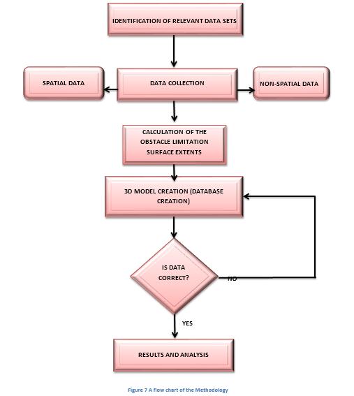
19 3. Methodology 19

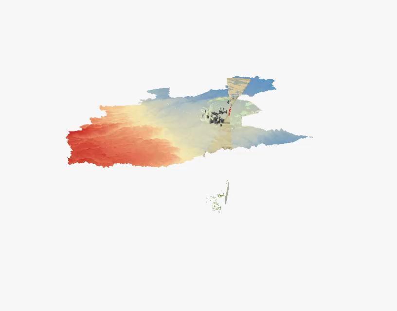
20 4. RESULTS AND ANALYSIS Figure 4.1 views from The ArcScene model created in Sketch up 20
 and (b)")

21 Figure 4.2 (a) and (b) Different views of the model 21
 buildings after")

22 Figure 4.3 (a) buildings after extrusion Figure 4.3 (b) Buildings within the model 22
 (b) Figure 4.")
23 ANALYSIS Intersection An intersection was done for the airspace surface and the buildings surface. The output was specified to be surface for the analysis of violation. The resulting images were as follows; (a) (b) Figure 4.5 (a) and (b) intersection results, side and aerial view respective;y 23
24 SUMMARY OF VIOLATION The final value after export of the attribute table to excel and analyzing it, was 203 out of the 1017 digitized buildings in violation of the airspace limitation surfaces regulations A visual analysis indicate that they are towards the edges of the inner horizontal surface. 24
25 5. CONCLUSIONS AND RECOMMENDATIONS The objective of the creation of a 3D Spatial Planning Model of the Imaginary surfaces in ArcGIS was achieved. The main imaginary surfaces were represented on the model, this included the horizontal surface, the conical surface and the approach surfaces that were used for evaluation purposes. Calculations were necessary for the creation of some surfaces in order to bring the surfaces from a mathematical description on paper to a 3D representation. The objective of using the 3D Spatial Planning model to identify developments that do not adhere to the guidelines and qualify to be categorized as airspace obstructions was also achieved. The intersection results were used to clearly visualize and analyze the violation of airspace obstruction guidelines by the buildings around the airport. Based on the above achievements, it is concluded that the overall objective of analyzing the airspace obstruction around the airport using 3D GIS was satisfactorily achieved. 25
26 RECOMMENDATIONS. The 3D model would be better created and details included e.g. the complex transitional surfaces using better design software other than ArcGIS and ArcScene that the Geospatial engineering student is conversant with. I recommend software such as sketch - up and AutoCAD for the creation of advanced and detailed conical and curved approach surfaces which are able to create better surfaces and there-by allowing for better analysis. A higher resolution DEM for the Nairobi Area and more for the Machakos neighborhood of the airport would be more useful and can be used for a very precise Obstruction study of the Airport. A LIDAR dataset is also recommended for the building surfaces and with this the DEM would not have been of such a low resolution. This would also in effect solve the height estimation issue once and for all by the heights being directly getting the heights from the LIDAR data of from accurate photogrammetric height extraction. 26
27 RECOMMENDATIONS In similar projects in future, access to buildings proposed by individuals would be of huge importance specifically for the analysis of their effects on the airspace and their obstruction status. It is also recommended for anyone doing a similar project in future to delve deeper and focus on the details of height zoning in the ICAO regulations. This would facilitate better recommendation on whether the building or obstacle should be demolished, marked or lit better. 27
28 28
29 Thank You very Much 29
Airport Obstruction Standards
 Airport Obstruction Standards Dr. Antonio Trani Department of Civil and Environmental Engineering Virginia Tech Outline of this Presentation Obstructions to navigation around airports Discussion of Federal
AERODROME LICENCE APPLICATION PROCESS
 0000180111 Page 2 Why is a Licence Required? An aerodrome licence is required for a site if it is intended to facilitate operations by commercial transport aircraft, other aerial work other than rotorcraft,
SITE ELEVATION AMSL...Ground Elevation in feet AMSL STRUCTURE HEIGHT...Height Above Ground Level OVERALL HEIGHT AMSL...Total Overall Height AMSL
 ******************************************** * Federal Airways & Airspace * * Summary Report * ******************************************** File: User Assigned File Name Latitude: NAD83 Coordinate Longitude:
AIR NAVIGATION ORDER
 CLEARANCE AREAS AND OBSTACLE LIMITATION SURFACES AT AIR NAVIGATION ORDER VERSION : 2.0 DATE OF IMPLEMENTATION : 15-02-2013 OFFICE OF PRIME INTEREST : AERODROME STANDARDS BRANCH. (Directorate of Airspace
Consideration will be given to other methods of compliance which may be presented to the Authority.
 Advisory Circular AC 139-10 Revision 1 Control of Obstacles 27 April 2007 General Civil Aviation Authority advisory circulars (AC) contain information about standards, practices and procedures that the
ORDINANCE NO. _2013-
 ORDINANCE NO. _2013- AN ORDINANCE OF THE TOWNSHIP OF CONEWAGO, DAUPHIN COUNTY, PENNSYLVANIA, PROVIDING FOR AIRPORT ZONING REGULATIONS WITHIN THE AIRPORT ZONING OVERLAY DISTRICT CREATED BY THIS ORDINANCE
Overview ICAO Standards and Recommended Practices for Aerodrome Safeguarding
 Overview ICAO Standards and Recommended Practices for Aerodrome Safeguarding References The Convention on International Civil Aviation (Chicago Convention) ICAO SARPS Annex 14 Vol. I, 7 th Edition, July
Electronic Terrain and Obstacle Data
 International Civil Aviation Organization Electronic Terrain and Obstacle Data David Lewtas Chief, Aeronautical Information Unit (MET/AIM) 24 November 2010 ICAO CAR AIM Seminar Kingston, Jamaica 22-24
The following criteria shall be applied within the boundaries of the AO District:
 Sec. 419 (a) Purpose AIRPORT OVERLAY DISTRICT (AO) The purpose of the Airport Overlay District is to regulate and restrict the height of structures, objects, or natural growth, regulate the locations of
TANZANIA CIVIL AVIATION AUTHORITY AIR NAVIGATION SERVICES INSPECTORATE. Title: CONSTRUCTION OF VISUAL AND INSTRUMENT FLIGHT PROCEDURES
 Page 1 of 8 1. PURPOSE 1.1. This Advisory Circular provides guidance to personnel involved in construction of instrument and visual flight procedures for publication in the Aeronautical Information Publication.
Appendix C AIRPORT LAYOUT PLANS
 Appendix C AIRPORT LAYOUT PLANS Appendix C AIRPORT LAYOUT PLANS Airport Master Plan Santa Barbara Airport As part of this Airport Master Plan, the Federal Aviation Administration (FAA) requires the development
Windmills & Airspace Can We Work Together?
 May 29, 2008 Windmills & Airspace Can We Work Together? J. Randolph Babbitt C O N F I D E N T I A L www.oliverwyman.com Windmills & Airspace Overview of Airspace Issues For Wind Turbine Sites The FAA s
Aerodrome Inspectors Workshop
 Aerodrome Inspectors Workshop Obstructions, Public Protection & Fencing Location: Trinidad & Tobago, 9-13 JUN 2014 Presenter: Herman Smith, FAA ACSI Date Presentation Title 1 Obstructions and Public Protection
DRAFT MASTER PLAN UPDATE
 DRAFT MASTER PLAN UPDATE CHAPTER VI: AIRPORT LAYOUT PLAN NARRATIVE DRAFT REPORT APRIL 2017 PREPARED BY: Table of Contents WESTCHESTER COUNTY AIRPORT 6 AIRPORT LAYOUT PLAN NARRATIVE REPORT... 6-1 6.1 AGIS
Chapter Six ALP Drawings. Tacoma Narrows Airport. Master Plan Update
 Chapter Six ALP Drawings Master Plan Update The master planning process for the (Airport) has evolved through efforts in the previous chapters to analyze future aviation demand, establish airside and landside
APPENDIX D FEDERAL AVIATION REGULATIONS, PART 77
 APPENDIX D FEDERAL AVIATION REGULATIONS, PART 77 Subparts A through C PART 77 - OBJECTS AFFECTING NAVIGABLE AIRSPACE Subpart A General 77.1 Scope. 77.2 Definition of terms. 77.3 Standards. 77.5 Kinds of
Lecture Minimum safe flight altitude
 Lecture Minimum safe flight altitude Calculate of minimum safe flight altitude, safe flight altitude in approach zone, in circle zone (circle altitude), minimum safe flight altitude in aerodrome area,
Analyzing Risk at the FAA Flight Systems Laboratory
 Analyzing Risk at the FAA Flight Systems Laboratory Presented to: Workshop By: Dr. Richard Greenhaw, FAA AFS-440 Date: 29 November, 2005 Flight Systems Laboratory Who we are How we analyze risk Airbus
AIRSPACE PROTECTION. Guidance and considerations for development in the vicinity of Ohio s airports and heliports
 AIRSPACE PROTECTION Guidance and considerations for development in the vicinity of Ohio s airports and heliports UPDATED SPRING 2018 AIRSPACE PROTECTION When construction is proposed near public use airports
DP-3 ICAO Electronic Terrain and. Amendments 33 & 36
 DP-3 ICAO Electronic Terrain and Obstacle Data Amendments 33 & 36 1 Published Amendment 33 to ICAO Annex 15, Chapter 10 July 2004, ICAO Annex 15(Aeronautical Information Services) addeda new Chapter 10
Regional implementation of Electronic Terrain and Obstacle data (e-tod) (Presented by Jeppesen)
 (Presented by Jeppesen)") International Civil Aviation Organization SAM/IG/13-WP/39 South American Regional Office 5/04/14 Thirteenth Workshop/Meeting of the SAM Implementation Group English only (SAM/IG/13) - Regional Project
International Civil Aviation Organization SAM/IG/13-WP/39 South American Regional Office 5/04/14 Thirteenth Workshop/Meeting of the SAM Implementation Group English only (SAM/IG/13) - Regional Project
Overview ICAO Standards and Recommended Practices for Aerodrome Mapping Data reported to AIM
 Overview ICAO Standards and Recommended Practices for Aerodrome Mapping Data reported to AIM References ICAO SARPS Annex 14 Vol. I, 7 th Edition, July 2016 ICAO SARPS Annex 15, 15 th Edition, July 2016
STAFF REPORT. Airport Land Use Consistency Determination Betteravia Plaza. MEETING DATE: January 21, 2016 AGENDA ITEM: 8D
 STAFF REPORT SUBJECT: Airport Land Use Consistency Determination Betteravia Plaza MEETING DATE: AGENDA ITEM: 8D STAFF CONTACT: Andrew Orfila RECOMMENDATION: Adopt findings for the Betteravia Plaza project
July 2008 COMPANY INDOCTRINATION TRAINING 1.0 PURPOSE
 ADVISORY CIRCULAR CAA-AC-OPS009A July 2008 COMPANY INDOCTRINATION TRAINING 1.0 PURPOSE This Advisory Circular (AC) specifies the objectives and content of company indoctrination curriculum segments applicable
Flying Cloud Airport (FCM) Zoning Process: Informing a Mn/DOT Path Forward
 Zoning Process: Informing a Mn/DOT Path Forward") : Informing a Mn/DOT Path Forward A Review of the Flying Cloud Airport (FCM) Joint Airport Zoning Board (JAZB) Process and the Draft Airport Zoning Ordinance B A RPZ RPZ A B C Zone Chad E. Leqve Director
: Informing a Mn/DOT Path Forward A Review of the Flying Cloud Airport (FCM) Joint Airport Zoning Board (JAZB) Process and the Draft Airport Zoning Ordinance B A RPZ RPZ A B C Zone Chad E. Leqve Director
RISING PERFORMANCE. Civil aviation is an outlier. It s BY ERIK DAHLBERG
 RISING PERFORMANCE Compact mobile mapping systems can be installed on small passenger cars. Civil aviation is an outlier. It s among the few industries where tight government regulations are widely accepted
Aerodrome Obstacle Survey Information Checks
 United Kingdom Overseas Territories Aviation Circular OTAC 139-20 Aerodrome Obstacle Survey Information Checks Issue 2.00 26 May 2017 Effective on issue GENERAL Overseas Territories Aviation Circulars
Part 77 and Construction
 Part 77 and Construction Presented to: By: Date: Advanced ASOS Steven Oetzell October 18, 2016 14 CFR Part 77, Objects Affecting Navigable Airspace Reporting objects to the FAA 14 CFR Part 139.331 states
Global Runway Safety Simposium
 Global Runway Safety Simposium A DIFFERENT PERSPECTIVE OF SAFETY AND ITS RELATIONSHIP WITH SURROUNDINGS Costantino Pandolfi LIMA, 11/21/2017 Italian Civil Aviation Authority ICAO ADOP Member Panel 8 New
NOTICE TO PROPOSED CITY PERMITS: ZONING HEIGHT RESTRICTIONS/APPROVAL PROCESS
 NOTICE TO PROPOSED CITY PERMITS: ZONING HEIGHT RESTRICTIONS/APPROVAL PROCESS Dear Prospective Permittee: The City of St Petersburg (City) issues permits for construction projects based on local and state
AMENDMENT No. 8 TO THE INTERNATIONAL STANDARDS AND RECOMMENDED PRACTICES AERODROMES ANNEX 14 TO THE CONVENTION ON INTERNATIONAL CIVIL AVIATION
 AMENDMENT No. 8 TO THE INTERNATIONAL STANDARDS AERODROMES ANNEX 14 TO THE CONVENTION ON INTERNATIONAL CIVIL AVIATION VOLUME I AERODROME DESIGN AND OPERATIONS The amendment to Annex 14, Volume I contained
Using LiDAR for Precise Vegetation Management
 Using LiDAR for Precise Vegetation Management Quantum Spatial is a proven partner to airport planners, engineers, facility managers, and contractors whose objective is to build, expand, and make improvements
It is essential that planning take full account of air safety and efficiency of operations.
 Airspace Protection Airspace Protection It is essential that planning take full account of air safety and efficiency of operations. 7.1 INTRODUCTION Obstacles near an airport, whether they are natural
AUGUST 2017 GNSS REVIEW. Survey Economics Chances of success. Mobile Mapping Airport scanning. Stag s Leap Winery Pre-construction plan
 AUGUST 2017 GNSS REVIEW Survey Economics Chances of success Stag s Leap Winery Pre-construction plan Mobile Mapping Airport scanning RISING PERFORMANCE» ERIK DAHLBERG Civil aviation is an outlier. It s
RNP AR APCH Approvals: An Operator s Perspective
 RNP AR APCH Approvals: An Operator s Perspective Presented to: ICAO Introduction to Performance Based Navigation Seminar The statements contained herein are based on good faith assumptions and provided
Airport Master Plan. Brookings Regional Airport. Runway Runway 17-35
 Runway 17-35 Airport Master Plan Runway 12-30 Brookings Regional Airport Table of Contents Table of Contents Chapter 1: Master Plan Goals... 1-1 1.1. Introduction... 1 1.2. Objective 1 Identify improvements
Challenges in Complex Procedure Design Validation
 Challenges in Complex Procedure Design Validation Frank Musmann, Aerodata AG ICAO Workshop Seminar Aug. 2016 Aerodata AG 1 Procedure Validation Any new or modified Instrument Flight Procedure is required
Operators may need to retrofit their airplanes to ensure existing fleets are properly equipped for RNP operations. aero quarterly qtr_04 11
 Operators may need to retrofit their airplanes to ensure existing fleets are properly equipped for RNP operations. 24 equipping a Fleet for required Navigation Performance required navigation performance
Federal GIS Conference February 10 11, 2014 Washington DC. ArcGIS for Aviation. David Wickliffe
 Federal GIS Conference 2014 February 10 11, 2014 Washington DC ArcGIS for Aviation David Wickliffe What is ArcGIS for Aviation? Part of a complete system for managing data, products, workflows, and quality
Assignment 7: Airport Geometric Design Standards
 CEE 4674: Airport Planning and Design Spring 2018 Date Due: March 23, 2018 Instructor: Trani Problem 1 Assignment 7: Airport Geometric Design Standards An airport is designing a new pier terminal to accommodate
Saint Petersburg-Clearwater International Airport. Airspace & Instrument Approach Analysis
 Saint Petersburg-Clearwater International Airport Airspace & Instrument Approach Analysis February 23, 2005 Jeppesen Boeing Jeppesen Government / Military Services Group Airspace Services Division AIRSPACE
The offers operators increased capacity while taking advantage of existing airport infrastructure. aero quarterly qtr_03 10
 The 747 8 offers operators increased capacity while taking advantage of existing airport infrastructure. 14 aero quarterly qtr_03 10 Operating the 747 8 at Existing Airports Today s major airports are
Agenda: SASP SAC Meeting 3
 Agenda: SASP SAC Meeting 3 Date: 04/12/18 Public Involvement Plan Update Defining the System Recommended Classifications Discussion Break Review current system Outreach what we heard Proposed changes Classification
REGULATION No. 10/2011 ON APPROVAL OF FLIGHT PROCEDURES INCLUDING SID-s AND STAR-s. Article 1 Scope of Application
 Republika e Kosovës Republika Kosovo Republic of Kosovo Autoriteti i Aviacionit Civil i Kosovës Autoritet Civilnog Vazduhoplovstva Kosova Civil Aviation Authority of Kosovo Director General of Civil Aviation
Part 77 CAA Consolidation 1 April 2014 Objects and Activities Affecting Navigable Airspace
 Part 77 CAA Consolidation 1 April 2014 Objects and Activities Affecting Navigable Airspace Published by the Civil Aviation Authority of New Zealand DESCRIPTION Part 77 prescribes rules for persons proposing
4.2 AIRSPACE. 4.2 Airspace. Supplemental Draft Environmental Impact Statement August 2008 Military Training Activities at Mākua Military Reservation
 4.2 AIRSPACE 4.2.1 Impact Methodology Impacts on airspace use were assessed by evaluating the potential effects of the proposed training activities on the principal attributes of airspace use, as described
RNP In Daily Operations
 RNP In Daily Operations Article 2 Paul Malott WestJet It was a dark and stormy night in the mountainous terrain of Kelowna, British Columbia. Suddenly, the noise of a jet airplane on final pierced the
According to FAA Advisory Circular 150/5060-5, Airport Capacity and Delay, the elements that affect airfield capacity include:
 4.1 INTRODUCTION The previous chapters have described the existing facilities and provided planning guidelines as well as a forecast of demand for aviation activity at North Perry Airport. The demand/capacity
Boise Municipal Code. Chapter DEFINITIONS
 Chapter 12-03 DEFINITIONS Sections: 12-03-01 ADMINISTRATOR 12-03-02 AIRPORT DESIGNATIONS 12-03-03 AIRPORT HAZARD 12-03-04 AIRPORT HEIGHT LIMITATIONS 12-03-05 AIRPORT REFERENCE POINT 12-03-06 AIRPORT INSTRUMENT
Chapter 1. Draw Standard Departure Procedure
 Chapter 1. Draw Standard Departure Procedure 1. Prior to drawing departure area consult the US Terminal Procedures book to determine if there are published take off special Take Off Minimums and (Obstacle)
AIRPORT ZONING REGULATIONS for the City of McPherson, Kansas
 AIRPORT ZONING REGULATIONS for the City of McPherson, Kansas ARTICLE 1. TITLE, PURPOSE, AUTHORITY AND JURISDICTION 100 Title. These regulations, including the McPherson Airport Zoning Map made a part hereof,
The purpose of this Demand/Capacity. The airfield configuration for SPG. Methods for determining airport AIRPORT DEMAND CAPACITY. Runway Configuration
 Chapter 4 Page 65 AIRPORT DEMAND CAPACITY The purpose of this Demand/Capacity Analysis is to examine the capability of the Albert Whitted Airport (SPG) to meet the needs of its users. In doing so, this
CATCODE ] CATCODE
![CATCODE ] CATCODE](/thumbs/82/85644630.jpg "CATCODE ] CATCODE") Runways. FAC: 1111 CATCODE: 111111 OPR: AFCEC/COS OCR: AF/A3O-A 1.1. Description. The runway is the paved surface provided for normal aircraft landings and take offs. Runways are classified as either Class
Runways. FAC: 1111 CATCODE: 111111 OPR: AFCEC/COS OCR: AF/A3O-A 1.1. Description. The runway is the paved surface provided for normal aircraft landings and take offs. Runways are classified as either Class
AERONAUTICAL SURVEYS & INSTRUMENT FLIGHT PROCEDURES
 AERONAUTICAL SURVEYS & INSTRUMENT FLIGHT PROCEDURES Current as of November 2012 ALASKA AVIATION SYSTEM PLAN UPDATE Prepared for: State of Alaska Department of Transportation & Public Facilities Division
STAFF REPORT. Airport Land Use Plan Consistency Review: Santa Barbara Airport Master Plan. MEETING DATE: November 19, 2015 AGENDA ITEM: 7D
 STAFF REPORT SUBJECT: Airport Land Use Plan Consistency Review: Santa Barbara Airport Master Plan MEETING DATE: AGENDA ITEM: 7D STAFF CONTACT: Peter Imhof, Andrew Orfila RECOMMENDATION: Adopt findings
Learning Objectives 7.3 Flight Performance and Planning Flight Planning & Flight Monitoring
 030 00 00 00 FLIGHT PERFORMANCE AND PLANNING 033 00 00 00 FLIGHT PLANNING AND FLIGHT MONITORING 033 01 00 00 FLIGHT PLANNING FOR VFR FLIGHTS Remark Using Training Route Manual VFR charts or CQB Annexes
CFIT-Procedure Design Considerations. Use of VNAV on Conventional. Non-Precision Approach Procedures
 OCP-WG-WP 4.18 OBSTACLE CLEARANCE PANEL WORKING GROUP AS A WHOLE MEETING ST. PETERSBURG, RUSSIA 10-20 SEPTEMBER 1996 Agenda Item 4: PANS-OPS Implementation CFIT-Procedure Design Considerations Use of VNAV
Planning and Designing Airport Infrastructure to Support GPS and PBN Approach Development
 ACRP Problem Statement 16-07-04 Recommended Allocation: -- Planning and Designing Airport Infrastructure to Support GPS and PBN Approach Development ACRP Staff Comments -- TRB Aviation Committee Comments
Procedures for Air Navigation Services Aerodromes (PANS-AGA) ICAO Doc. 9981
 ICAO Doc. 9981") Procedures for Air Navigation Services Aerodromes (PANS-AGA) ICAO Doc. 9981 Introduction The First Edition of Doc. 9981 was approved by the President of the Council on 20 October 2014 The document becomes
Procedures for Air Navigation Services Aerodromes (PANS-AGA) ICAO Doc. 9981 Introduction The First Edition of Doc. 9981 was approved by the President of the Council on 20 October 2014 The document becomes
SUBCHAPTER E AIRSPACE
 PART 71 DESIGNATION OF CLASS A, B, C, D, AND E AIRSPACE AREAS; AIR TRAFFIC SERVICE ROUTES; AND REPORTING POINTS Sec. SPECIAL FEDERAL AVIATION REGULATION NO. 97 [NOTE] 71.1 Applicability. 71.3 [Reserved]
CONTROLLED AIRSPACE CONTAINMENT POLICY
 Safety and Airspace Regulation Group (SARG) 17 January 2014 Policy Statement 1 Overview CONTROLLED AIRSPACE CONTAINMENT POLICY 1.1 UK airspace design policy for ATS Routes, SIDs and STARs is based upon
Advisory Circular AC19-1. Test Pilot Approvals 03 July Revision 0
 Advisory Circular AC19-1 Revision 0 Test Pilot Approvals 03 July 2009 General Civil Aviation Authority Advisory Circulars contain information about standards, practices, and procedures that the Director
INTERNATIONAL FIRE TRAINING CENTRE
 INTERNATIONAL FIRE TRAINING CENTRE RFFS SUPERVISOR INITIAL LICENSING OF AERODROMES CHAPTER 8 THE MINIMUM REQUIREMENTS TO BE MET IN THE PROVISION OF RESCUE AND FIRE FIGHTING SERVICES AT UK LICENSED AERODROMES
AERONAUTICAL SERVICES ADVISORY MEMORANDUM (ASAM) Focal Point : Gen
 Focal Point : Gen") Page 1 of 8 1. INTRODUCTION 1.1. This material has been prepared to provide step-by-step guidance on the application of performance-based navigation (PBN) in developing an Airspace Change Proposal (ACP).
Page 1 of 8 1. INTRODUCTION 1.1. This material has been prepared to provide step-by-step guidance on the application of performance-based navigation (PBN) in developing an Airspace Change Proposal (ACP).
STAFF REPORT. Airport Land Use Plan Consistency Review: Old Town Village Mixed Use Project City of Goleta. MEETING DATE: June 18, 2015 AGENDA ITEM: 5M
 STAFF REPORT SUBJECT: Airport Land Use Plan Consistency Review: Old Town Village Mixed Use Project City of Goleta MEETING DATE: AGENDA ITEM: 5M STAFF CONTACT: Peter Imhof, Andrew Orfila RECOMMENDATION:
AVIATION PLANNING AND DEVELOPMENT Oakland International Airport 530 Water Street Oakland, CA 94607
 AVIATION PLANNING AND DEVELOPMENT Oakland International Airport 530 Water Street When Do I Need to File an FAA Form 7460-1? Objects Affecting Navigable Airspace (14CFR77) June 2013 Background The Federal
GREATER GEELONG PLANNING SCHEME PROPOSED AMENDMENT FOR THE PROTECTION OF EMERGENCY MEDICAL SERVICE HELICOPTER FLIGHTPATHS SERVING GEELONG HOSPITAL
 GREATER GEELONG PLANNING SCHEME PROPOSED AMENDMENT FOR THE PROTECTION OF EMERGENCY MEDICAL SERVICE HELICOPTER FLIGHTPATHS SERVING GEELONG HOSPITAL APRIL 2014 Report Prepared for The Minister for Health
-NOTE: NOT TO BE USED FOR NAVIGATION PURPOSES-
 APPENDIX 1-B INSTRUMENT APPROACH PROCEDURES March 2010 SKYHAVEN AIRPORT -NOTE: NOT TO BE USED FOR NAVIGATION PURPOSES- -NOTE: NOT TO BE USED FOR NAVIGATION PURPOSES- -NOTE: NOT TO BE USED FOR NAVIGATION
CHAPTER 3 ALTERNATIVES CONSIDERED
 CHAPTER 3 ALTERNATIVES CONSIDERED 3.0 ALTERNATIVES The 2010 Stevensville Airport Master Plan contained five (5) airside development options designed to meet projected demands. Each of the options from
Implementation of PBN in Armenian airspace
 Implementation of PBN in Armenian airspace PBN implementation plan, based on the specifications of the airspace of the Republic of Armenia, has been developed in accordance with Resolution A36-23, approved
Airport Runway Location and Orientation. CEE 4674 Airport Planning and Design
 Airport Runway Location and Orientation CEE 4674 Airport Planning and Design Dr. Antonio A. Trani Professor of Civil Engineering Virginia Tech Virginia Tech 1 of 24 Runway Location Considerations The following
RULES OF TENNESSEE DEPARTMENT OF TRANSPORTATION AERONAUTICS DIVISION CHAPTER LICENSING AND REGISTRATION OF AIRPORTS TABLE OF CONTENTS
 RULES OF TENNESSEE DEPARTMENT OF TRANSPORTATION AERONAUTICS DIVISION CHAPTER 1680-1-2 LICENSING AND REGISTRATION OF AIRPORTS TABLE OF CONTENTS 1680-1-2-.01 Purpose 1680-1-2-.06 Repealed 1680-1-2-.02 Definitions
AERODROME SAFETY COORDINATION
 AERODROME SAFETY COORDINATION Julio Garriga, RO/TA International Civil Aviation Organization North American, Central American and Caribbean Office ICAO NACC Regional Office Page 1 Coordination of the aerodrome
FACILITY REQUIREMENTS SUMMARY OF KEY ISSUES OVERVIEW
 FACILITY REQUIREMENTS SUMMARY OF KEY ISSUES OVERVIEW This summary is intended to provide a brief overview of the key issues associated with conformance to FAA standards at Methow Valley State Airport.
AERONAUTICAL SERVICES ADVISORY MEMORANDUM (ASAM) Focal Point: Gen
 Focal Point: Gen") Page 1 of 14 1 INTRODUCTION This guidance material has been prepared for use for the definition of protected surfaces in the vicinity of aerodromes. Survey information for an aerodrome is essential for
Page 1 of 14 1 INTRODUCTION This guidance material has been prepared for use for the definition of protected surfaces in the vicinity of aerodromes. Survey information for an aerodrome is essential for
Re: Findings Regarding Possible Impacts of Proposed Rockfort Quarry on Aviation Activities at Brampton Airport
 Mr. Christopher J. Tzekas, Partner, WeirFoulds LLP, The Exchange Tower, Suite 1600, P.O. Box 480, 130 King Street West, Toronto, Ontario, M5X 1J5. May 8, 2010. Re: Findings Regarding Possible Impacts of
International Civil Aviation Organization HIGH-LEVEL CONFERENCE ON AVIATION SECURITY (HLCAS) Montréal, 12 to 14 September 2012
 Montréal, 12 to 14 September 2012") International Civil Aviation Organization HLCAS-WP/5 4/6/12 WORKING PAPER HIGH-LEVEL CONFERENCE ON AVIATION SECURITY (HLCAS) Montréal, 12 to 14 September 2012 Agenda Item 7: The role of the Machine Readable
International Civil Aviation Organization HLCAS-WP/5 4/6/12 WORKING PAPER HIGH-LEVEL CONFERENCE ON AVIATION SECURITY (HLCAS) Montréal, 12 to 14 September 2012 Agenda Item 7: The role of the Machine Readable
SAFEGUARDING OF AERODROMES. Advice Note 1
 AIRPORT OPERATORS ASSOCIATION & GENERAL AVIATION AWARENESS COUNCIL supported by CIVIL AVIATION AUTHORITY Working in Co-operation SAFEGUARDING OF AERODROMES Advice Note 1 Safeguarding - An Overview 1. The
Runway Length Analysis Prescott Municipal Airport
 APPENDIX 2 Runway Length Analysis Prescott Municipal Airport May 11, 2009 Version 2 (draft) Table of Contents Introduction... 1-1 Section 1 Purpose & Need... 1-2 Section 2 Design Standards...1-3 Section
APPENDIX D MSP Airfield Simulation Analysis
 APPENDIX D MSP Airfield Simulation Analysis This page is left intentionally blank. MSP Airfield Simulation Analysis Technical Report Prepared by: HNTB November 2011 2020 Improvements Environmental Assessment/
Source: Chippewa Valley Regional Airport ASOS, Period of Record
 Chapter 1 Inventory Runway wind coverage is the percentage of time a runway can be used without exceeding allowable crosswind velocities. Allowable crosswind velocities vary depending on aircraft size
L 342/20 Official Journal of the European Union
 L 342/20 Official Journal of the European Union 24.12.2005 COMMISSION REGULATION (EC) No 2150/2005 of 23 December 2005 laying down common rules for the flexible use of airspace (Text with EEA relevance)
Route Causes. The largest percentage of European helicopter. For helicopters, the journey not the destination holds the greatest risk.
 draganm /Fotolia.com Route Causes For helicopters, the journey not the destination holds the greatest risk. BY RICK DARBY The largest percentage of European helicopter accidents in 00 05 studied by the
JOSLIN FIELD, MAGIC VALLEY REGIONAL AIRPORT DECEMBER 2012
 1. Introduction The Federal Aviation Administration (FAA) recommends that airport master plans be updated every 5 years or as necessary to keep them current. The Master Plan for Joslin Field, Magic Valley
Merritt Island Airport
 TABLE OF CONTENTS CHAPTER 1 INTRODUCTION... 1-1 INTRODUCTION AND PROJECT OVERVIEW... 1-1 General Guidelines... 1-1 Prior Planning Documentation... 1-2 Key Issues... 1-2 Goals and Objectives... 1-2 Regulatory
AIRPORT LAND USE COMPATILIBILTY AIRPORT LAND USE COMPATIBILIITY
 CHAPTER 7 AIRPORT LAND USE COMPATILIBILTY CHAPTER 7 AIRPORT LAND USE COMPATIBILIITY 7.0 INTRODUCTION On airport aviation related development is typically compatible with aircraft operations. On airport
Appendix B Ultimate Airport Capacity and Delay Simulation Modeling Analysis
 Appendix B ULTIMATE AIRPORT CAPACITY & DELAY SIMULATION MODELING ANALYSIS B TABLE OF CONTENTS EXHIBITS TABLES B.1 Introduction... 1 B.2 Simulation Modeling Assumption and Methodology... 4 B.2.1 Runway
CHAPTER 5 SEPARATION METHODS AND MINIMA
 CHAPTER 5 SEPARATION METHODS AND MINIMA 5.1 Provision for the separation of controlled traffic 5.1.1 Vertical or horizontal separation shall be provided: a) between IFR flights in Class D and E airspaces
2015 PURDUE ROAD SCHOOL March 11, 2015
 2015 PURDUE ROAD SCHOOL March 11, 2015 Runway Protection Zone (RPZ) Definition It is a trapezoidal shape formed off the end of a runway and its geometry it a function of the airport s aircraft approach
PROPOSED INVERCARGILL CITY DISTRICT PLAN. Decision No. 28G. Invercargill Airport Ltd Designations
 PROPOSED INVERCARGILL CITY DISTRICT PLAN Decision No. 28G Invercargill Airport Ltd Designations Hearings Committee Councillor Darren Ludlow (Chair) Councillor Neil Boniface Councillor Graham Sycamore Keith
California State University Long Beach Policy on Unmanned Aircraft Systems
 California State University, Long Beach June 14, 2016 Policy Statement: 16-04 California State University Long Beach Policy on Unmanned Aircraft Systems The following policy statement was recommended by
FLIGHT OPERATIONS PANEL (FLTOPSP)
") International Civil Aviation Organization FLTOPSP/1-WP/3 7/10/14 WORKING PAPER FLIGHT OPERATIONS PANEL (FLTOPSP) FIRST MEETING Montréal, 27 to 31 October 2014 Agenda Item 4: Active work programme items
International Civil Aviation Organization FLTOPSP/1-WP/3 7/10/14 WORKING PAPER FLIGHT OPERATIONS PANEL (FLTOPSP) FIRST MEETING Montréal, 27 to 31 October 2014 Agenda Item 4: Active work programme items
DEPARTMENT: CIVIL ENGINEERING SEMESTER: III SUBJECT CODE / Name: CE2303/ Railway, Airport and Harbors Engineering 2 MARK QUESTIONS AND ANSWERS
 DEPARTMENT: CIVIL ENGINEERING SEMESTER: III SUBJECT CODE / Name: CE2303/ Railway, Airport and Harbors Engineering 2 MARK QUESTIONS AND ANSWERS 1.Define wind Coverage (AUC NOV/DEC 2010),(AUC NOV/DEC 2011)
Andres Lainoja Eesti Lennuakadeemia
 Andres Lainoja Eesti Lennuakadeemia In the beginning was the Word... Convention on International Civil Aviation (Doc 7300) was signed on 7 December 1944 International Civil Aviation Organization began
Effective Altitude. R-3103 To 30,000 (To 9,144 meters) Source: NACO 2002 Notes: 1 By NOTAM issued 12 hours in advance
 Source: NACO 2002 Notes: 1 By NOTAM issued 12 hours in advance") 8.4 AIRSPACE USE 8.4.1 Affected Environment The affected airspace environment is described below in terms of its principal attributes, namely controlled and uncontrolled airspace, special use airspace,
8.4 AIRSPACE USE 8.4.1 Affected Environment The affected airspace environment is described below in terms of its principal attributes, namely controlled and uncontrolled airspace, special use airspace,
GUIDELINES FOR AERONAUTICAL STUDY
 1. INTRODUCTION 1.1 Detailed procedures for assessing and issuing No Objection Certificate for height clearance to proposed structures are given in SO84 E, issued by Govt. of India in Jan. 2010, as revised
2015 GDOT PowerPoint
 Obstruction Evaluation 2015 GDOT PowerPoint GAA Title Spring Page Conference What are all these surfaces? February 19, 2016 Sub Titles Presented By Alan Hood, Airport Safety Body Text Data Program Manager
USE AND APPLICATION OF GNSS IN THE IMPLEMENTATION OF NAVIGATION BASED ON PERFORMANCE IN ECUADOR
 BACKGROUND OF GNSS USE The guidelines for the transition to the use of the Global Navigation Satellite System GNSS in the CAR / SAM Regions were issued by ICAO at the Eleventh World Air Navigation Conference
Federal Aviation Administration DCA. By: Terry Biggio, Vice President Air Traffic Services Date: June 18, Federal Aviation Administration
 DCA Presented to: Arlington County By: Terry Biggio, Vice President Air Traffic Services Date: June 18, 2015 Air Traffic Roles and Responsibilities As aviation technology advances, the FAA is putting in
REPUBLIC OF BULGARIA MINISTRY OF TRANSPORT, INFORMATION TECHNOLOGY AND COMMUNICATIONS
 REPUBLIC OF BULGARIA MINISTRY OF TRANSPORT, INFORMATION TECHNOLOGY AND COMMUNICATIONS TO ALL INTERESTED PERSONS IN THE PROCEDURE FOR GRANTING A CONCESSION FOR SERVICE FOR THE OBJECT CIVIL AIRPORT FOR PUBLIC