South, Southeast, and East Asia Physical Geography
|
|
|
- Clement Gaines
- 5 years ago
- Views:
Transcription

1 South, Southeast, and East Asia Physical Geography
2
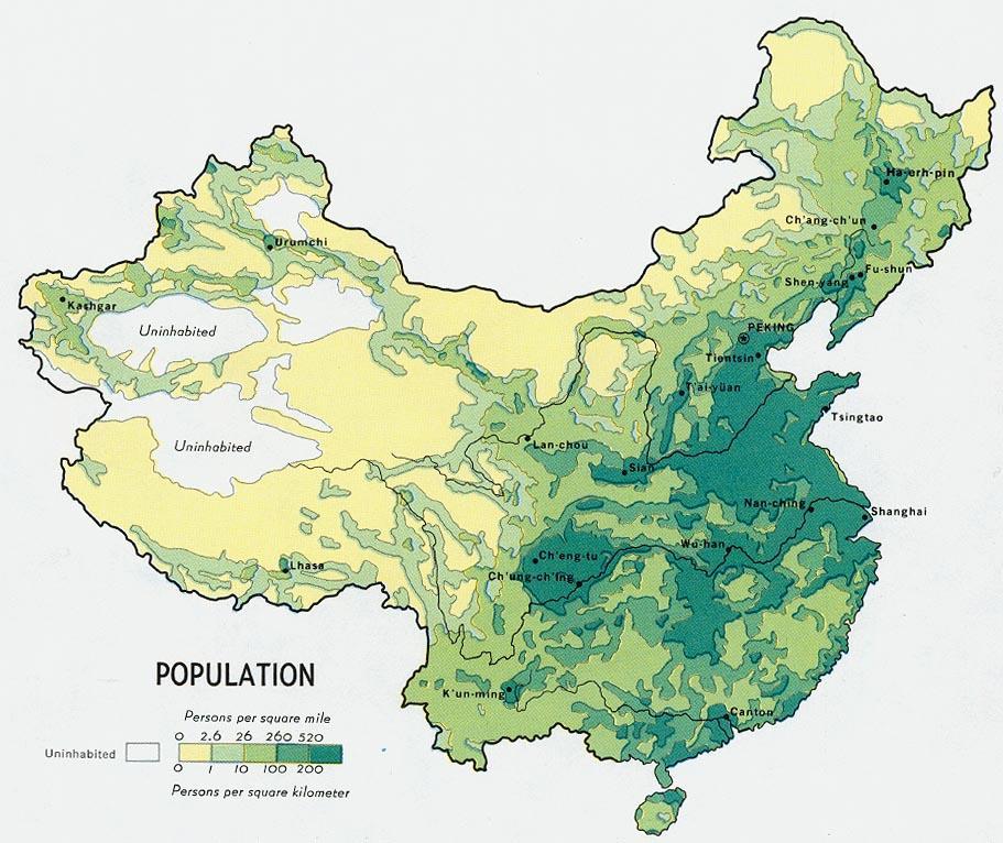
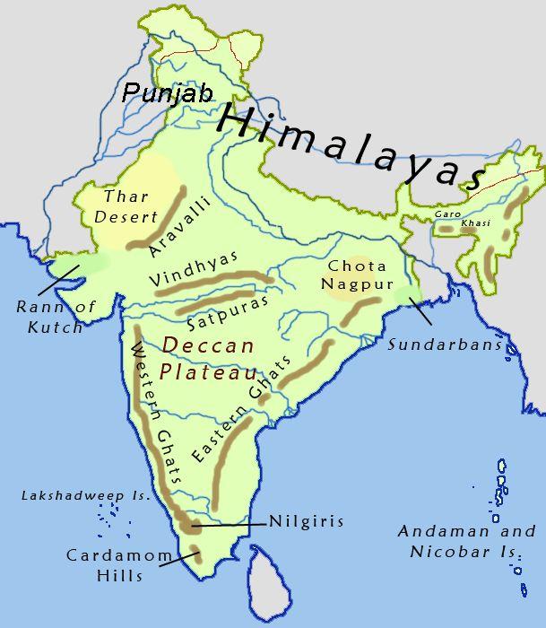
3 Mountains A. B. C. Mountains are important in Asia because they influence: Population patterns Movement of people and goods Climate

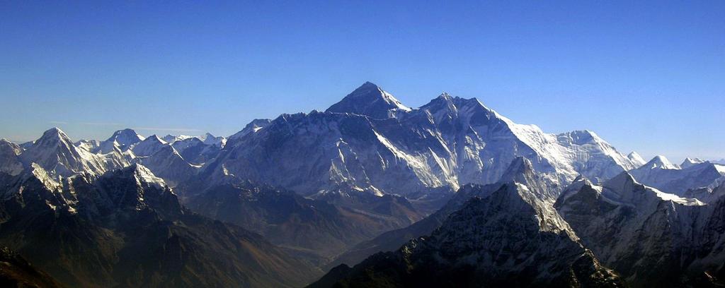
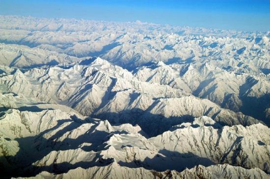
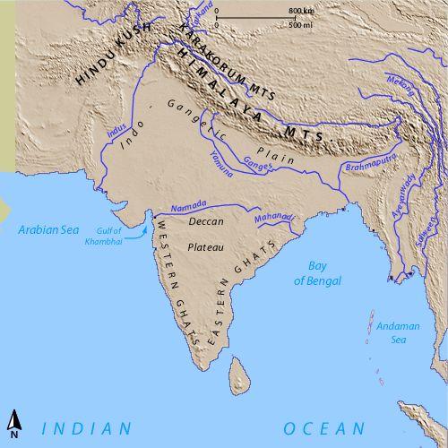
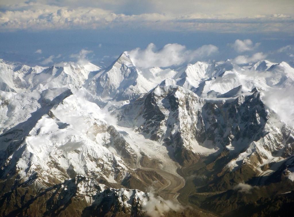
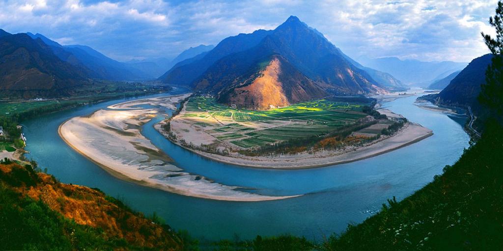
4 Himalaya Mountains The most important mountain range in Asia is the Himalaya Mountains. The Himalayas separate India from China. The Himalayas block clouds that are formed by monsoons from entering Western China. The Himalayas isolate Tibet and make transportation difficult.
5

6 Mount Everest The highest point in the Himalayas Everest is 29,035 feet high Over 60 million years old There are 18 different climbing routes It takes 40 days to reach the summit to allow your body to adjust to the high altitude.
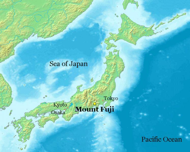
7 Mountains A. B. C. D. Some other mountains in Asia are: The Hindu-Kush The Eastern and Western Ghats in India The Tian Shan Mountains Mount Fuji in Japan
8 Hindu Kush Mountains The name Kush, which means death, was probably given to the mountains because of the dangerous passes between the peaks. Some of these high-altitude passes were used by Alexander the Great and others in their invasions of India. The mountains have permanently glaciated peaks and little vegetation.
9
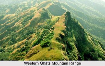
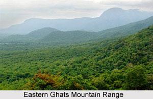
10 The Eastern and Western Ghats in India Two mountain ranges forming the eastern and western edges, respectively, of the peninsula of India. Eastern Ghats have a gentle slope Western Ghats have steeper elevations with many swiftly flowing rivers and waterfalls.
11
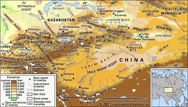
12 Tian Shan Mountains Also called Tien Shan, Celestial Mountains or Heavenly Mountains Length of 1,553 miles from east to west Stretches through 4 countries China, Kazakhstan, Kyrgyzstan and Uzbekistan
13

14 Fuji Mountains Mount Fuji is the tallest mountain in Japan at 12,388 ft. The mountain is located on the island of Honshu and it is considered sacred by Shintos. An active stratovolcano that last erupted in Mt. Fuji is noted to be one of the most symmetrical in nature
15
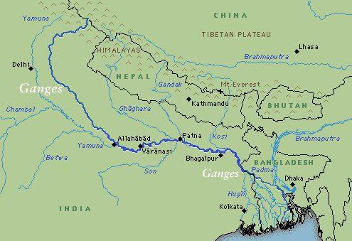
16
17 Plateaus and Uplands Most of Western China is on a plateau called the Plateau of Tibet. Farther north is the Mongolian Plateau. The Korean Peninsula and the Japanese Islands are both very mountainous.

18 Plateau of Tibet Also referred to as the Tibetan Plateau Highest plateau in the world Average elevation of 16,000 ft Nicknames The roof of the world The third pole Asian water tower Covered with glaciers, lakes, rivers, grasslands & fertile farmland
 Shared between Mongolia China")
19 Mongolian Plateau Cover approximately 1,000,000 sq miles Is made up of the Gobi Desert and Steppe (raised farmland) Shared between Mongolia China Russia
 - lies")

20 Korean Peninsula & Japanese Islands Korean Peninsula 70% is covered with mountains Highest mountains are found in the north and east Active volcano Baekdu Mountain (9,002 ft) - lies on the border between North Korea and China Japanese Islands Covered with mountains most heavily forested Only 15% of Japan is suitable for farmland which is also where most people can live.
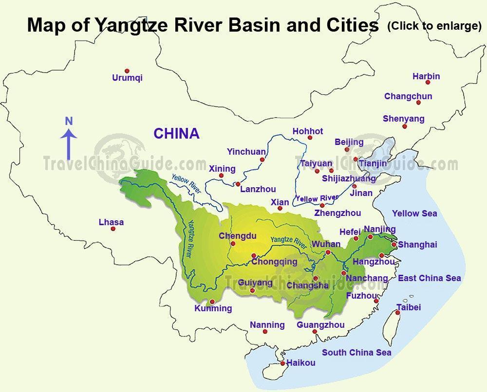
21 Rivers and Bodies of Water Many rivers in Asia start in the Himalaya Mountains. Rivers erode away the mountains and carry sediment (little bits of dirt) down to the flat plains at the base of the mountains. The sediment makes the soil by the rivers fertile and a good place to farm.
22 Rivers and Bodies of Water A. B. C. The most important rivers in South Asia are: The Indus The Ganges The Brahmaputra
23 Rivers and Bodies of Water The Ganges and Brahmaputra start in the Himalayas and flow into the Bay of Bengal. Both rivers flow through Bangladesh and as a result, this country often floods during the monsoon season.
24
25 The Ganges Is about 1,557 miles long & 200 to 400 miles wide The Ganges river basin has the highest population of any river basin in the world containing over 400 million people! Is considered sacred by Hindus
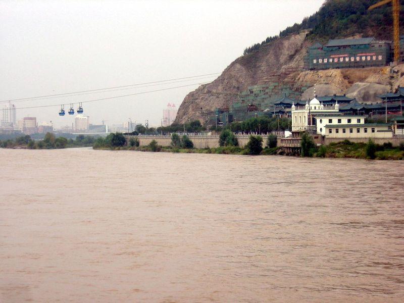
26 The Ganges Hindus build temples on the banks of the Ganges River. One city, Varanasi, is considered sacred by Hindus and the focal point of pilgrimages. Hindus often pray in the water and when they die many are cremated and the ashes cast into the river.

27 The Ganges The Ganges River has become one of the most polluted rivers in the world due to: A. Pesticides and fertilizers that spill into the river. B. Chemicals and metals from factories. C. Raw sewage D. Human use

28 Varanasi on the Ganges River
29 Brahmaputra river One of the biggest and most important rivers in Asia It flows over a course of 1,800 mi through China India Bangladesh The Brahmaputra is considered the fifth strongest river in the world


30 Indus River Pakistan s longest river 1,988 mi long Provides water for agriculture, food production and supports industry Also serves as main source of drinking water for people
31 The Rivers of China China has three major rivers that begin in the Himalayas and flow into the East China Sea or Yellow Sea. River Chinese Name Yellow River Huang He Yangtze River Chang Jiang West or Pearl River Xi Jiang
32 The Rivers of China The Yangtze and Yellow Rivers flow through an area that is flat in elevation called the North China Plain. This area has intensive farming and the two rivers are connected by The Grand Canal.
33 Chang Jiang River (Yangtze) Longest river in both China & Asia 3rd longest river in the world Travels 3,915 miles Most important river in China Source Plateau of Tibet Mouth East China Sea
34
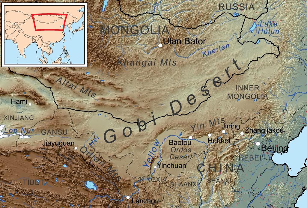
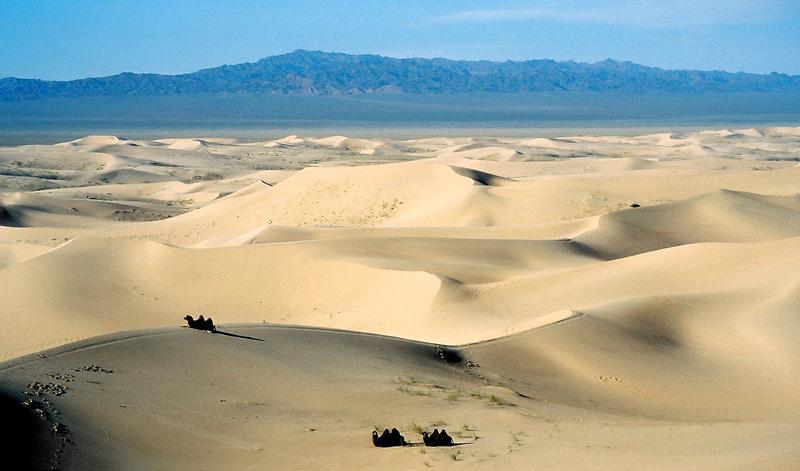
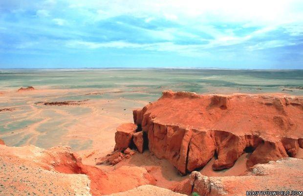
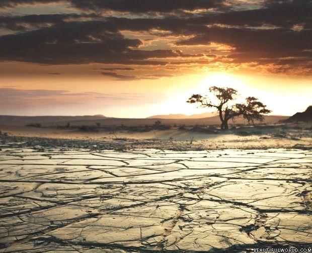
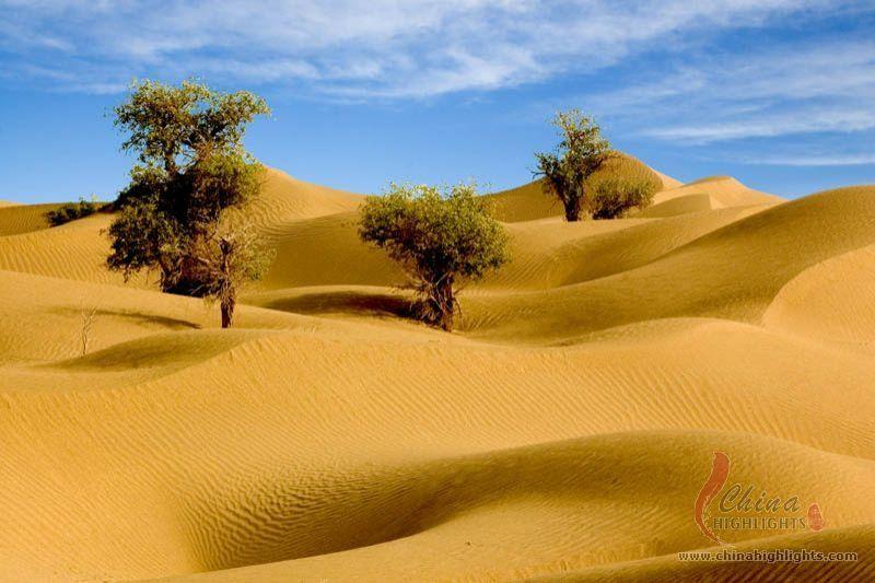
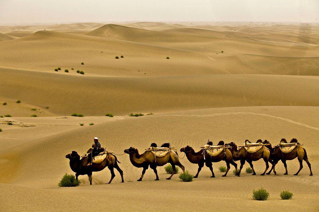
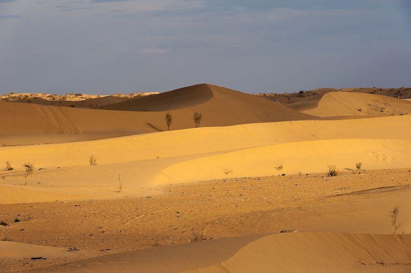
35 Huang He River (Yellow) 2nd longest river in China Travels 3,395 miles The type of dirt found here is called loess. It is a rich soil that is yellow in color and normally deposited by the wind. Source Plateau of Tibet Mouth Yellow Sea

36 The Yellow River

37 Xi Jiang River (West or Pearl) Travels 1,216 miles smaller than other rivers in China but delivers high volume of water The part of the river contains shells which are pearl colored. This is what gives the river its name Mouth South China Sea

38 Other Rivers of China Amur River Source: Great Khingan Mountains in Northern China Mouth: Sea of Japan. This river is also a border between China and Russia.

39 Rivers in Southeast Asia Mekong River The longest river in Southeast Asia. Source: Himalayas Mouth: South China Sea Flows through 4 countries China Laos Cambodia Vietnam


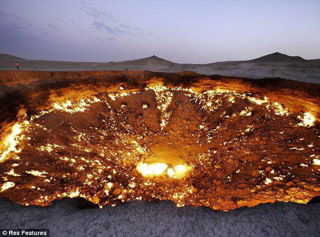
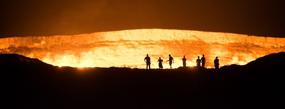
40 Bodies of Water Asia is surrounded by bodies of water. One important body of water is the Sea of Japan. Located between the Korean Peninsula and Japan. In Korea they refer to it as the East Sea.


41 Lake Baikal Located in Siberian Russia Deepest lake in the world 5,387 ft deep World s largest and oldest freshwater lake in the world One of the world s clearest and puriest bodies of water.

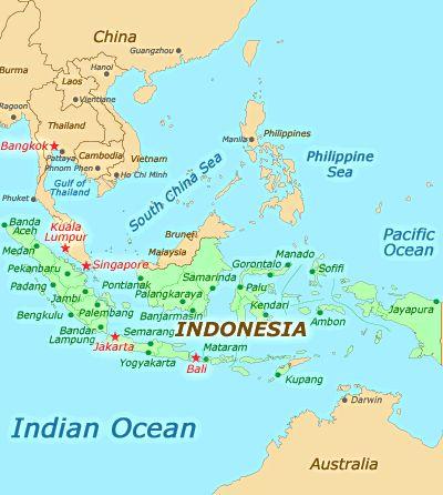
42 Bay of Bengal Is the largest bay in the world This bay forms the southern border of Asia
43

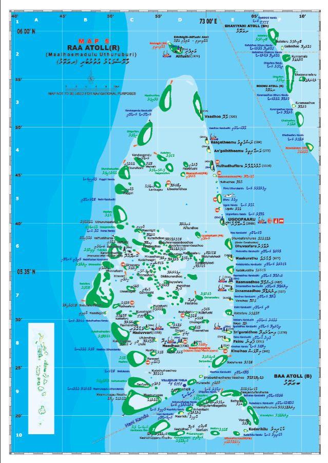
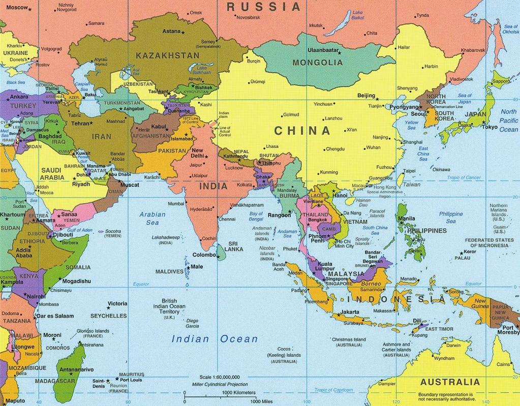
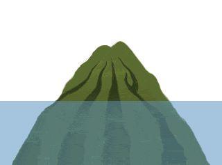
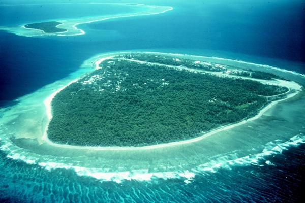
44 Deserts Asia s major deserts break the stereotype of rolling sand dunes radiating with heat and feature trees, plantations, mountains and occasional frost.
45 The Gobi Desert Gobi means waterless place The largest desert in this area is the Gobi Desert. Approximately 500,000 sq mi Shared between China & Mongolia 5th largest desert in the world Lies in a rain shadow of the Himalayas. Cold desert located on a plateau 3,000-5,000 ft in elevation Only 5% of desert is sand dunes Mostly made up of mountains,
46
47 Taklamakan Desert Known as Place of Ruins or Sea of Death Warmest & driest desert in China Less than ½ in of rainfall per year Covered mostly by sand dunes days are boiling hot nights are freezing cold One of China s natural borders
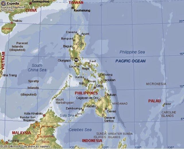
48

49 Karakum Desert Translation - Black Sand Covers 90% of the country of Turkmenistan Heavy winds and sandstorms create large sand dunes long, hot dry summers warm winters only in of rainfall a year Some of the world s largest deposits of oil, natural gas and sulfur. Geological accident created the Door to Hell crater
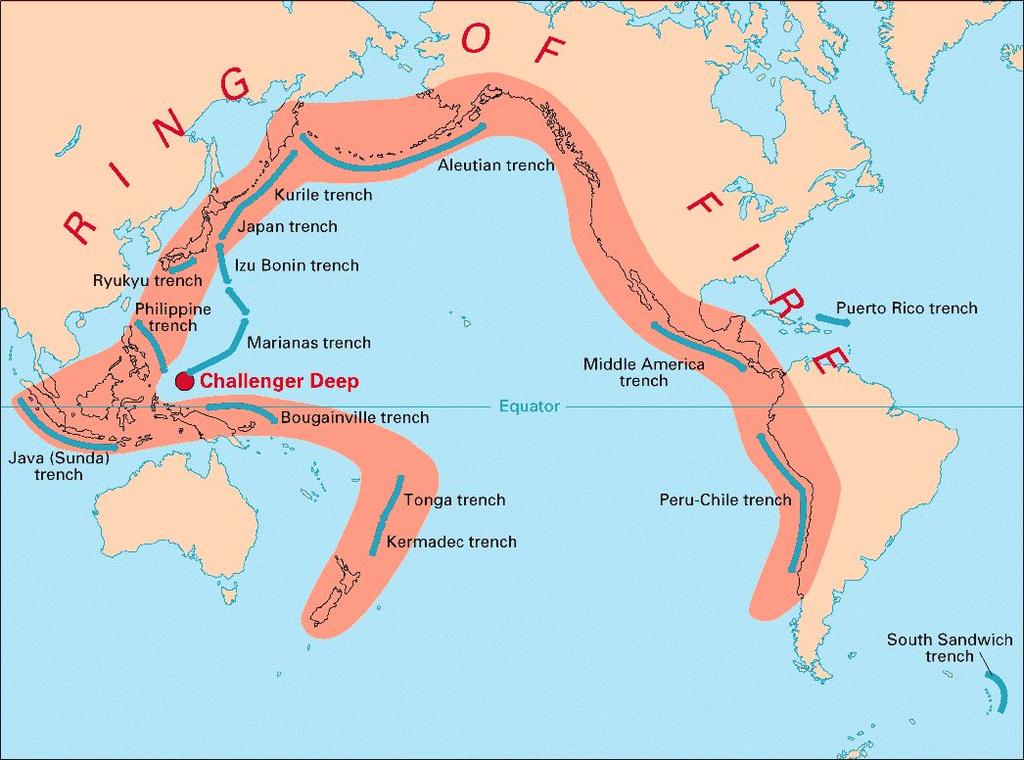
50
51 Islands A. B. C. D. A group of islands is called an archipelago. There are many archipelagos in Asia such as: Japan Philippines Indonesia Maldives


52 Japan Phi lipp Maldives Indonesia ines
53 Maldives The islands are atolls, the tops of submerged volcanoes surrounded by coral reefs. The Maldives are located off of the southwest coast of India in the Indian Ocean. There are over 1200 small islands in the archipelago. Only 200 are inhabited
54
55

56 Taiwan Taiwan is a large island off of the coast of China. Taiwan used to be called Formosa by the Portuguese. The Democratic Republic of China is a country that is on the island. Some people just call the country Taiwan in order to avoid confusion.

57 Other Islands Some other major islands in Asia are: Taiwan Hainan Sri Lanka Singapore

58 Singapore Singapore is an island at the tip of the Malay Peninsula. The country of Singapore is located on the island and it has become very wealthy because it is on a strategic waterway, The Strait of Malacca.
59 Ring of Fire Part of Asia is on The Ring of Fire, an area around the Pacific Ocean where many tectonic plates meet. This area is at a greater risk for having earthquakes and active volcanoes. Parts of Taiwan, Japan and the Philippines are located on the ring of fire
60
STUDY GUIDE. The Land. Chapter 29, Section 1. Both. Terms to Know DRAWING FROM EXPERIENCE ORGANIZING YOUR THOUGHTS
 Chapter 29, Section 1 For use with textbook pages 719 724. The Land Terms to Know cordilleras Parallel mountain ranges and plateaus (page 719) archipelago A group of islands (page 720) insular Relating
Chapter Objectives. Describe the dominant landforms and natural resources of Southeast Asia. Discuss Southeast Asia s climate and vegetation.
 Chapter Objectives Describe the dominant landforms and natural resources of Southeast Asia. Discuss Southeast Asia s climate and vegetation. The Land Section 1 Objectives Describe how tectonic plates and
Friday, November 10, 2017
 Friday, November 10, 2017 Andes and Midlatitude Countries Objective: Summarize the main physical features and regions of the Southern Cone. Identify and locate the urban centers and understand the pattern
OUR COUNTRY INDIA L OCATIONAL SETTING
 7 India is a country of vast geographical expanse. In the north, it is bound by the lofty Himalayas. The Arabian Sea in the west, the Bay of Bengal in the east and the Indian Ocean in the south, wash the
Label your Map with Russia. Map Activity
 Bell Activity How many time zones does the U.S. have? How do these time zones affect life in the U.S.? Russia is so large it has 11 time zones. What difficulties might this create? Objectives Know landforms,
Chapter 14. The Physical Geography of Russia
 Chapter 14 The Physical Geography of Russia Chapter Objectives Identify the physical features and natural resources of Russia. Discuss the effects of Russia s climate and vegetation on life in the region.
Rivers. Highlights of some of the World s Most Famous Rivers!
 Rivers Highlights of some of the World s Most Famous Rivers! Directions This Power Point presentation contains information about some of the most famous rivers in the world! Students should use this presentation
Monday, December 11, 2017
 Monday, December 11, 2017 Physical Geography of Russia Objective: complete Warm-Up, write outline notes and discuss the geography of Eastern Europe/mother Russia and view Geography Now: Belarus. География
Just how big is Africa?
 The United States China India The United Kingdom Portugal Spain France Belgium Germany The Netherlands Switzerland Italy Eastern Europe Japan 11.7 million sq. miles Just how big is Africa? Chapter 18 Section
The Geological Pacific Northwest. Wednesday February 6, 2012 Pacific Northwest History Mr. Rice
 The Geological Pacific Northwest Wednesday February 6, 2012 Pacific Northwest History Mr. Rice 1 Free Response #2 Please do not simply list the items for this response. Full sentences!!! Minimum of 3-5
Chapter 20. The Physical Geography of Africa South of the Sahara
 Chapter 20 The Physical Geography of Africa South of the Sahara Chapter Objectives Identify the major landforms, water systems, and natural resources of Africa south of the Sahara. Describe the relationship
Unit 1: Physical Geography Notes
 - How has the physical world impacted settlement patterns? o Major factors in the decision-making process of o Before the boom controlling the physical environment was not possible on a large scale - Physical
PHYSICAL GEOGRAPHY. Unit 1
 PHYSICAL GEOGRAPHY Unit 1 HOW HAS THE PHYSICAL WORLD IMPACTED SETTLEMENT PATTERNS? Major factor in the decision-making process of settlers Before the technological boom controlling the physical environment
CH. 1 Europe and Russia: Physical Geography. Section 1 Land and Water p Europe and Russia are part of the world s largest landmass called.
 CH. 1 Europe and Russia: Physical Geography Section 1 Land and Water p.10-16 Europe and Russia are part of the world s largest landmass called. The country of Russia stretches over both continents. About
STUDY GUIDE. The Land. Chapter 17, Section 1. There are frequent earthquakes in the region. Petroleum is a major export in the region.
 For use with textbook pages 421 426. The Land Terms to Know alluvial soil A rich soil made up of sand and mud deposited by flowing water (page 423) wadi A streambed that remains dry until a heavy rain
The Himalayan Future Transition, Equity and Ecological Stability. Jayanta Bandyopadhyay
 The Himalayan Future Transition, Equity and Ecological Stability Jayanta Bandyopadhyay Himalaya the Mountain of Diversity The Himalaya has been mentioned in many writings, both ancient and modern, scientific
Latin America. Physical Geography
 Latin America Physical Geography Regions Latin America can be divided into separate regions based on physical geography or cultural geography. Regions If we look at physical geography Latin America has
Chapter 17. North Africa, Southwest Asia and Central Asia
 Chapter 17 North Africa, Southwest Asia and Central Asia Chapter Objectives Describe the major landforms and natural resources of North Africa, Southwest Asia, and Central Asia. Discuss the climate and
Chapter 7 Geography and the Early Settlement of Egypt, Kush, and Canaan
 Chapter 7 Geography and the Early Settlement of Egypt, Kush, and Canaan How did geography affect early settlement in Egypt, Kush, and Canaan? Section 7.1 - Introduction RF/NASA//Corbis This satellite photograph
HIST-WG Singleton WG 2nd 6 Weeks' Exam
 HIST-WG Singleton WG 2nd 6 Weeks' Exam [Exam ID:2NDJK9] Scan Number:253 1 In the Asian region, there have been great strides in agricultural advancements and technology which have enabled greater food
STUDY GUIDE. The Land. Chapter 20, Section 1. The Land of Africa South of the Sahara. Landforms Water Systems Natural Resources.
 For use with textbook pages 499 504. The Land Terms to Know escarpment A steep, often jagged slope or cliff (page 500) cataract A towering waterfall (page 500) rift valley A large crack in the earth s
Oceania. Australia, New Zealand, and the Pacific Islands. Physical Geography. Where is Australia located?
 Oceania Australia, New Zealand, and the Pacific Islands Physical Geography Australia New Zealand Oceania Where is Australia located? Australia & Oceania are a group of islands located between Asia, Antarctica,
AFRICAN PHYSICAL GEOGRAPHY
 AFRICAN PHYSICAL GEOGRAPHY Here are some factoids about Africa: world s second largest continent (11,700,000 miles). Home to 52 countries, 1,000 languages, 800 million people. 10% of the world s population
STUDY GUIDE. The Land. Physical Features of Latin America. Chapter 8, Section 1. Terms to Know DRAWING FROM EXPERIENCE ORGANIZING YOUR THOUGHTS
 For use with textbook pages 193 198. The Land Terms to Know cordillera A mountain range that runs parallel to another mountain range (page 194) altiplano A high plain (page 194) escarpment A steep cliff
Unit 9 The Middle East SG 1 - Physical Geography, Population & Demographics
 Unit 9 The Middle East SG 1 - Physical Geography, Population & Demographics I. Physical Geography A. The Middle East includes southwestern Asia and North Africa. 1. The name is Eurocentric. Middle East
China: Natural Environments. Outline. Group Discussion. Territory and Location. Neighbors. Topography Hydrology/river systems. News on China?
 News on China? China: Natural Environments Youqin Huang GOG/EAS 160 1 Youqin Huang GOG/EAS 160 2 Group Discussion What are the most significant physical features in China? Name two What are their implications
Japan is basically a mountainous volcanic Island Chain located in the western Pacific Ocean
 I N T R O D U C T I O N T O J A PA N Japan is basically a mountainous volcanic Island Chain located in the western Pacific Ocean The country has four main Islands HOKKAIDO HONSHU SHIKOKU KYUSHU And then
Chapter 15: RUSSIA & The REPUBLICS
 Chapter 15: RUSSIA & The REPUBLICS Ch. 15:1 Landforms & Resources The Northern European Plain stretches for over 1,000 miles between the western border of Russia & the Republics and the. Ural Mountains
UNIT 5 PHYSICAL GEOGRAPHY SG 1 - PART I
 UNIT 5 PHYSICAL GEOGRAPHY SG 1 - PART I Africa is HUGE! I. LANDFORMS A. Plateaus - an area of relatively level high ground. 1. Africa s interior is dominated by series of plateaus and elevated basins such
NZQA registered unit standard version 2 Page 1 of 5. Demonstrate knowledge of Asian countries as tourist destinations
 Page 1 of 5 Title Demonstrate knowledge of Asian countries as tourist destinations Level 3 Credits 8 Purpose People credited with this unit standard are able to: locate Asian countries, and key cities,
Chapter 7. Geography and the Early Settlement of Egypt, Kush, and Canaan
 Chapter 7 Geography and the Early Settlement of Egypt, Kush, and Canaan Chapter 7 Geography and the Early Settlement of Egypt, Kush, and Canaan How did geography affect early in Egypt Kush, and Canaan?
Responding to Climate Change. Tourism Initiatives in Asia and the Pacific
 Responding to Climate Change Tourism Initiatives in Asia and the Pacific Table of Contents Acknowledgements 7 Foreword 9 Tourism responses to climate change in Asia and the Pacific: an introduction 11
Latin America s Physical Geography. EQ: What are characteristics of Latin America s physical features?
 Latin America s Physical Geography EQ: What are characteristics of Latin America s physical features? Your Task: We are going to participate in a Museum Walk! You will travel around the room with a partner
Ancient Egypt and the Near East
 *O*»f ' i ft Ancient Egypt and the Near East Chapter 7 Chapter 8 Chapter 9 Geography and the Early Settlement of Egypt, Kush, and Canaan The Ancient Egyptian P h a r a o h s Daily Life in Ancient Egypt
Wednesday, April 4, 2018
 Wednesday, April 4, 2018 Physical Geography of Japan Objective: Outline the countries and territories that are included in East Asia. Describe the main physical features and climate types of each country.
Travelling In Southeast Asia: Hong Kong, Indochina, Indonesia, Malaysia, Philippines, Singapore, Thailand By Paul Gaffey READ ONLINE
 Travelling In Southeast Asia: Hong Kong, Indochina, Indonesia, Malaysia, Philippines, Singapore, Thailand By Paul Gaffey READ ONLINE If searched for a ebook Travelling in Southeast Asia: Hong Kong, Indochina,
Physical Geography of Europe. Chapters 13-18
 Physical Geography of Europe Chapters 13-18 The British Isles Archipelago made of 6000+ small islands Temperate climate Largest body of fresh water is Loch Ness Mostly rolling hills and large flat lands
PROMOTING REGIONAL COOPERATION IN TOURISM EDUCATION AND TRAINING
 3 RD Global Summit on Peace through Tourism 2-55 October 2005 Pattaya,, Thailand PROMOTING REGIONAL COOPERATION IN TOURISM EDUCATION AND TRAINING Presentation By: Ryuji Yamakawa, Tourism Unit, United Nations
Mediterranean Sea Persian Gulf Red Sea Tigris River Euphrates River Sumer Fertile Crescent
 GEOGRAPHY MESOPOTAMIA MAP Mediterranean Sea Persian Gulf Red Sea Tigris River Euphrates River Sumer Fertile Crescent ACHIEVEMENT INTELLECT RELIGION POLITICS SOCIETY ECONOMY N Fertile Crescent - lots of
What is meant by site?
 Site and Situation What is meant by site? Site is the actual location of a city. Example NYC is located on a large, deep water harbor, next to the Atlantic Ocean. What is meant by situation? Situation
Mexico. Chapter 10. Chapter 10, Section
 Chapter 10, Section World Geography Chapter 10 Mexico Copyright 2003 by Pearson Education, Inc., publishing as Prentice Hall, Upper Saddle River, NJ. All rights reserved. Chapter 10, Section World Geography
The Lesser Antilles. Dominican Republic), and Puerto Rico
, and Puerto Rico") The Caribbean Islands are archipelagoes or groups of islands. The major archipelagoes are: The Greater Antilles - Cuba, Jamaica, Hispaniola (Composed of Haiti and the Dominican Republic), and Puerto Rico
The Caribbean Islands are archipelagoes or groups of islands. The major archipelagoes are: The Greater Antilles - Cuba, Jamaica, Hispaniola (Composed of Haiti and the Dominican Republic), and Puerto Rico
Ms. Susan M. Pojer Horace Greeley HS Chappaqua, NY
 Ms. Susan M. Pojer Horace Greeley HS Chappaqua, NY Europe as a Queen Munster, 1588 Europe s s Latitude v. US Former Soviet Region Compared in Latitude & Area with the United States Satellite View of Europe
Grade 5 Geography Term 1
 1 Grade 5 Geography Term 1 Contents Section 1: World map and compass directions... 2 The position of the equator and the North and South Poles on a globe... 2 The seven continents of the world... 3 The
LOCATION, CLIMATE, AND NATURAL RESOURCES OF MEXICO
 SS6G3 The student will explain the impact of location, climate, distribution of natural resources, and population distribution on Latin America and the Caribbean. a. Compare how the location, climate,
Do Not Write On This Sheet. World Rally. City, country, continient: to city, country, continent:
 World Rally At each checkpoint you must list the city, country, and continent. The teacher must check all answers before you can go on to the next checkpoint. Checkpoint 1: Start at: 29 N 98 W and go to:
absolute building land water
 Site and Situation What makes a city great? Why are some cities better than others? Cities developed for a variety of reasons. Site and situation are important geographic concepts when studying the reasons
Latin America. Chapter 9 Physical Geography
 Latin America Chapter 9 Physical Geography Latin American Regions Middle America includes Mexico and the Central American countries The Caribbean Islands South America Mexico Landforms Sierra Madre Oriental
3rd GRADE MINIMUM CONTENTS UDI 1: LANDSCAPES (5)
") 3rd GRADE MINIMUM CONTENTS UDI 1: LANDSCAPES (5) DIFFERENT LANDSCAPES A landscape is all the things that we see in a place. There are different types of landscapes. Mountain landscapes have mountains and
3rd GRADE MINIMUM CONTENTS UDI 1: LANDSCAPES (5) DIFFERENT LANDSCAPES A landscape is all the things that we see in a place. There are different types of landscapes. Mountain landscapes have mountains and
Chapter 13 Eastern Europe & Western Russia: Recovering from war, communism, genocide, and unfortunate geography (Pg )
") Chapter 13 Eastern Europe & Western Russia: Recovering from war, communism, genocide, and unfortunate geography (Pg. 393-420) Lesson 1: Physical Geography of Eastern Europe & Western Russia Pg. 396-401
Chapter 13 Eastern Europe & Western Russia: Recovering from war, communism, genocide, and unfortunate geography (Pg. 393-420) Lesson 1: Physical Geography of Eastern Europe & Western Russia Pg. 396-401
Mountains. Erinn Banting
 Mountains Erinn Banting Published by Weigl Publishers Inc. 350 5 th Avenue, Suite 3304, PMB 6G New York, NY 10118-0069 Web site: www.weigl.com Copyright 2007 Weigl Publishers Inc. All rights reserved.
Objective. Students will familiarize themselves with the physical features and climates of Latin America.
 Journal Write KWL What do you KNOW about Latin America? What do you WANT TO KNOW about Latin America? What did you LEARN today that you didn t know before? Latin America Objective Students will familiarize
Terms to Know. artesian well coral atoll krill lagoon
 Chapter Objectives Describe the diverse landforms and natural resources of Australia, Oceania, and Antarctica. Discuss the wide range of climates and vegetation throughout the region. The Land Section
6th Grade Social Studies Chapter 7: The Geography and Early Settlement of Egypt, Kush and Canaan
 I. Introduction (7.1) A. Egyptians settled along the Nile River, in the NE corner of Africa B. civilization lasted from around 3100 B.C. to 350 C. E. C. Kushites settled to the south of Egypt, along the
Mrs. Davis s Adventures
 Mrs. Davis s Adventures Latin America Countries & Political Map NAME: DATE: PERIOD: DIRECTIONS: Use your mapping skills and textbook pages: 127, 97, and 3 to complete Mrs. Davis s Story. Transfer the countries
Introduction to Africa
 Introduction to Africa Did you know? Africa has more countries than any other continent. The Sahara is a desert that is the size of the U.S. It s the world's largest desert. Most of the world s gold and
Chapter 7: The Geography and Settlement of Egypt, Kush, and Canaan
 Chapter 7: The Geography and Settlement of Egypt, Kush, and Canaan Learning Target: I can explain how geography affected early settlement in Egypt, Kush, and Canaan. Ancient Egypt and the Middle East Can
Latin America. Physical Geography
 + Latin America Physical Geography + I. Landforms A. Caribbean & Central America 1. Mexico is dominated by two mountain chains, collectively called the Sierra Madre. A high plateau is situated in between.
GEOGRAPHY AND HISTORY
 GEOGRAPHY AND HISTORY YEAR 1, PART 1 www.vicensvives.es Contents 01 Our planet Earth 02 The representation of the Earth: maps 03 The Earth s relief 04 Rivers and seas 05 Weather and climate 06 Climates
Latin America and The Caribbean. A Closer Look.
 Latin America and The Caribbean A Closer Look. Mexico Capital: Mexico City The Location of Mexico Mexico is the second-largest country by size and population in Latin America.but the Largest Spanish -
IUCN Asia and biodiversity data
 IUCN Asia and biodiversity data James Tallant Senior Programme Officer Species IUCN Natural Resources Group, Asia June 2017 INTERNATIONAL UNION FOR CONSERVATION OF NATURE IUCN Overview Founded in 1948,
Exploring Mexico. Directions: Complete the paragraphs below. Write the correct word from the Word Bank to complete each sentence.
 Exploring Mexico Section 1 10 Directions: Complete the paragraphs below. Write the correct word from the Word Bank to complete each sentence. Word Bank United States Central Plateau irrigation isthmus
Congressional Briefing Southern California Air Cargo Traffic and its Impact on the Region s Economy
 Congressional Briefing Southern California Air Cargo Traffic and its Impact on the Region s Economy World Trade Week Briefing Series Los Angeles Chamber of Commerce Thursday, March 17, 2011 The Role of
Lesson 1: Introduction to Japan...3. Lesson 2: Resources of Japan...9. Lesson 3: People of Japan Lesson 4: Religions of Japan...
 CONTENTS: Lesson 1: Introduction to Japan..........................................3 Lesson 2: Resources of Japan...........................................9 Lesson 3: People of Japan.............................................16
largest deployments by number of staff deployed Pakistan: Earthquake 2005 Haiti: Earthquake 2010** Pakistan: Floods 2010 Typhoon Haiyan 2013
 United Nations Disaster Assessment and Coordination Missions (UNDAC): from 99 to 0 The United Nations Disaster Assessment and Coordination (UNDAC) team is part of the Office for the Coordination of Humanitarian
Religious Tourism in Asia and the Pacific
 Religious Tourism in Asia and the Pacific Table of Contents Acknowledgements Ix Executive Summary xiii Introduction xxv Section 1 - Introductory Essays 1 1 Pilgrims between East and West 1 1.1 The Difficulty
Location, Climate, & Natural Resources
 Location, Climate, & Natural Resources UK is a country of islands off the coast of mainland Europe. It consists of England, Northern Ireland, Scotland, & Wales. UK s location makes it a HUB for trade.
Region 1 Piney Woods
 Region 1 Piney Woods Piney Woods 1. This ecoregion is found in East Texas. 2. Climate: average annual rainfall of 36 to 50 inches is fairly uniformly distributed throughout the year, and humidity and temperatures
PHYSIOGRAPHIC DIVISION OF INDIA
 PHYSIOGRAPHIC DIVISION OF INDIA INTRODUCTION India is vast country there have great diversity in it s physical features. Physical Division Of India are divided into following five Division. 1. The Northern
VOLCANO DISCOVERY 5 days
 5 days Countries visited Philippines Tour Highlights Trek to Mount Pinatubo Take a boat to Lake Taal's inner volcano Witness smoking Mount Mayon - the perfect conical volcano Places visited Legazpi Tagaytay
Latin America. Introduction
 Latin America Introduction What are the 5 Themes of Geography? Draw lines to connect the theme to the definition: Location How humans and the environment impact each other Physical and human characteristics
Chapter 2A: The Russian Realm
 Geography: Realms, Regions, and Concepts 16 th Edition Chapter 2A: The Russian Realm The Russian Realm Two transition zones mark the margins. The Russian Realm Two transition zones mark the margins. Physical
CHAPTER 12. South America. Section 1: Natural Environments Section 2: History and Culture Section 3: South America Today. HOLT World Geography
 CHAPTER 12 South America Section 1: Natural Environments Section 2: History and Culture Section 3: South America 1 Section 1 Natural Environments Objectives: What are the major landforms and rivers of
Brain Wrinkles. Location, Climate, & Natural Resources of. Where People Live & How They Trade
 Location, Climate, & Natural Resources of Where People Live & How They Trade It s south of the US, east of the Pacific Ocean, and west of the Gulf of Mexico & Caribbean Sea. It s great that it s located
SS7G1 The student will locate selected features of Africa.
 Standards SS7G1 The student will locate selected features of Africa. a. Locate on a world and regional political-physical map: the Sahara, Sahel, savanna, tropical rain forest, Congo River, Niger River,
Portuguese Language - Fostering National Unity
 Geography Brazil Brazil Portuguese Language - Fostering National Unity 11 dialects of Portuguese Influenced by Amerindian and African languages, creating differences between Portuguese spoken in Brazil
Location, Climate, & Natural Resources Brain Wrinkles
 Location, Climate, & Natural Resources Standards SS6G10 The student will explain the impact of location, climate, natural resources, and population distribution on Europe. a. Compare how the location,
Our winter collection for 2018 is inspired by two major destinations: the Andean countries and Japan.
 Our winter collection for 2018 is inspired by two major destinations: the Andean countries and Japan. Unlike previous years we leave the cities for the majesty of lakes and mountains, discovering new harmonies,
TAIPEI, Taiwan EVA Air joins the Star Alliance network, further strengthening the Alliance s presence in Asia-Pacific.
 Wider choice in growing Cross-Straits market TAIPEI, Taiwan EVA Air joins the Star Alliance network, further strengthening the Alliance s presence in Asia-Pacific. At the official joining ceremony held
Coral Reef status in South Asian Seas Region and its possible restoration partnering with other Agencies
 Coral Reef status in South Asian Seas Region and its possible restoration partnering with other Agencies Dr. Sivaji Patra Senior Programme Officer (Regional) South Asian Seas Programme-SACEP 06 th December,
Mediterranean Europe
 Chapter 17, Section World Geography Chapter 17 Mediterranean Europe Copyright 2003 by Pearson Education, Inc., publishing as Prentice Hall, Upper Saddle River, NJ. All rights reserved. Chapter 17, Section
Accounting Basis by Country
 Accounting Basis by Country Egypt Africa Northern Africa Morocco Africa Northern Africa Sudan Africa Northern Africa Western Sahara Africa Northern Africa Angola Africa Sub-Saharan Africa Benin Africa
Domestic Tourism. in Asia and the Pacific
 Domestic Tourism in Asia and the Pacific Table of Contents Foreword 9 Acknowledgement 11 Executive Summary 13 Introduction 41 1 Australia 51 1.1 Domestic Tourism in Australia 51 1.1.1 Introduction 51 1.1.2
STANDARDS: Brain Wrinkles
 STANDARDS: SS6G3 The student will explain the impact of location, climate, distribution of natural resources, and population distribution on Latin America and the Caribbean. a. Compare how the location,
The Geography of the Middle East
 The Geography of the Middle East Unit 1 Focus The focus of this unit is how physical and cultural geography shape the environment, nations, and people of the Middle East The Middle East is also called
Kuruwita Erathna Trail to Sri Pada (Adam s Peak)
") Kuruwita Erathna Trail to Sri Pada (Adam s Peak) Trail Difficulty: Easy Moderate Strenuous Tough Trail Head: Adevikanda, Erathna (near entrance to mini-hydro power plant) Nearest Town: Erathna Nearest
Kuruwita Erathna Trail to Sri Pada (Adam s Peak) Trail Difficulty: Easy Moderate Strenuous Tough Trail Head: Adevikanda, Erathna (near entrance to mini-hydro power plant) Nearest Town: Erathna Nearest
Tentative Program. ** For Minister level **
 Tentative Program Pre-Conference Day 25 October, 2010. Pre-Conference Events(PCE) A. SAARC Issues and Approaches for DRR through CCA in South Asia B. Central Asia Disaster Risk Insurance Status in the
GEOPOLITICAL INDICATORS OF THE OCEANS. World Percentage Earth 29,6 Percentage oceans 36,2. 0,009 million km²
 EXCLUSIVE ECONOMIC ZONE (EEZ) World Percentage Earth 29,6 Percentage oceans 36,2 Highest and lowest value United States Jordan 12,2 million km² 0,009 million km² EEZ by developement level Number of countries
Financial Reporting Standards Adoption by Country
 Financial Reporting Standards Adoption by Country Egypt Africa Northern Africa Morocco Africa Northern Africa Sudan Africa Northern Africa Western Sahara Africa Northern Africa Angola Africa Sub-Saharan
4th Grade Social Studies 2nd Nine Weeks Test
 4th Grade Social Studies 2nd Nine Weeks Test Multiple Choice Identify the choice that best completes the statement or answers the question. 1 Which is the largest city in the United States? A Philadelphia,
Sprint Real Solutions Option A SDS International Outbound Rates from the U.S. Mainland, Hawaii, Puerto Rico, and the U.S.
 1* The international rates below apply to calls from the U.S. Mainland, Hawaii, Puerto Rico, and the U.S. Virgin Islands. For additional termination poinst for some countries, see International Termination
THE PHYSICAL AND CULTURAL GEOGRAPHY OF SOUTH AMERICA
 THE PHYSICAL AND CULTURAL GEOGRAPHY OF SOUTH AMERICA 1 Global location Relative to European capitals Relative to US cities Time zones Two oceans Pacific rim countries - farther to Asia than USA Not on
Himalayan Glaciers Climate Change, Water Resources, and Water Security. Henry Vaux, Committee Chair December 10, 2012
 Himalayan Glaciers Climate Change, Water Resources, and Water Security Henry Vaux, Committee Chair December 10, 2012 Study Context Glacial meltwater is commonly thought h to significantly ifi contribute
Mongolia from South to North.
 Mongolia from South to North. Discovery of Mongolia 4 X 4 Program, 4x4 and horse riding. A journey in a 4 x 4 car for 15 days between Mongolian steppes and mountains. Despite the vastness of the country,
Mrs. Reifsnyder World Geography. Unit 8: Latin America Study Guide SOLs Addressed: WG. 1c, 2b, 3c, 4, 10b/c
 Mrs. Reifsnyder World Geography Unit 8: Latin America Study Guide SOLs Addressed: WG. 1c, 2b, 3c, 4, 10b/c Essential Questions: - In what ways do physical, economic, and cultural characteristics influence
6th Grade Third Nine Weeks Benchmark Assessment
 6th Grade Third Nine Weeks Benchmark Assessment Multiple Choice Identify the choice that best completes the statement or answers the question. Key Concepts 1 Latin America is located in the A Northern
Chapter 4. Ancient Egypt and Kush Section 1: Geography & Ancient Egypt
 Chapter 4 Ancient Egypt and Kush Section 1: Geography & Ancient Egypt The gift of the nile Geography played a key role in the development of the Egyptian civilization. The Nile River brought life to Egypt.
Academic Vocabulary Social Studies, 5-8 (adapted from Building Academic Vocabulary by Robert Marzano.)
") Academic Vocabulary Social Studies, 5-8 (adapted from Building Academic Vocabulary by Robert Marzano.) Provide a student-friendly description, explanation, or example of the term. 7 Continents of the World
Academic Vocabulary Social Studies, 5-8 (adapted from Building Academic Vocabulary by Robert Marzano.) Provide a student-friendly description, explanation, or example of the term. 7 Continents of the World
Tranche 3
 ANNUAL REPORT 2017 www.adb.org/ar2017 Keywords: sovereign, commitments, loans, public sector Sovereign Commitments, 2017 ($ million) Funds Grant CENTRAL AND WEST ASIA 3,470.9 598.6 498.3 479.0-773.1 79.2
KINGDOM OF CAMBODIA NATION RELIGION KING 3
 KINGDOM OF CAMBODIA NATION RELIGION KING 3 TOURISM STATISTICS REPORT October 2015 MINISTRY OF TOURISM Statistics and Tourism Information Department No. A3, Street 169, Sangkat Veal Vong, Khan 7 Makara,