GEOGRAPHY AND HISTORY
|
|
|
- Aubrey Payne
- 5 years ago
- Views:
Transcription

1 GEOGRAPHY AND HISTORY YEAR 1, PART 1

2 Contents 01 Our planet Earth 02 The representation of the Earth: maps 03 The Earth s relief 04 Rivers and seas 05 Weather and climate 06 Climates and landscapes of the Earth 07 Climas Society y and paisajes the environment de España, Europa y la CA

3 Climates and landscapes of the Earth 1. The Earth s climates 2. Equatorial and tropical landscapes 3. Desert, polar and mountain landscapes 4. Oceanic and continental landscapes 5. The Mediterranean landscape 6. Europe s climates and landscapes 7. Spain s climates and landscapes
4 Introduction The Earth is divided into three climate zones: the hot zone, the temperate zones and the cold zones. The variety of climates creates many different types of landscapes. Most of Europe is in the temperate zone. The Iberian Peninsula is located in the south-west of Europe.


5 06 1. The Earth s climates 1.1. The Earth s climate zones The Earth s climate zones
6 1.1. The Earth s climate zones There are three climate zones on Earth: the hot zone, the temperate zones and the cold zones. The hot zone receives the most direct sunlight. It is between the Tropic of Cancer and the Tropic of Capricorn. The temperate zones have four seasons. They are between the tropical zone and the polar zone in both hemispheres. The cold zones are around the poles and in areas at altitudes of more than metres.

7 The Earth s climate zones

8 The Earth s climate zones
9 2. Equatorial and tropical landscapes 2.1. Equatorial landscapes 2.2. Inhabitants of the equatorial zone 2.3 Tropical landscapes 2.4 Inhabitants of the savanna The equatorial and tropical climates
10 2.1. Equatorial landscapes Equatorial landscapes are in areas near the equator: the Amazon, parts of Central America, the Congo, the Gulf of Guinea and Southeast Asia. The temperatures in these areas are high and rainfall is heavy and regular. Rivers in this climate have a high, regular flow. Vegetation is lush with abundant plant species and most animals are small.
11 2.2. Inhabitants of the equatorial zone Jungles in South America and Africa are sparsely populated and inhabitants live from fruit, hunting animals and basic farming. Asian jungles are more densely populated with plantations of rice, sugar cane, tea and latex to make rubber.
12 2.3. Tropical landscapes Tropical landscapes are in areas to the north and south of the equatorial area. The temperatures are high all year. There are two seasons: the rainy season and the dry season. River flow varies depending on the season. Grasslands with shrubs and isolated trees called savannas are common in tropical zones.
13 2.4. Inhabitants of the savanna People in some indigenous villages keep animals and raise livestock. Other villages depend on agriculture and practice crop rotation. There are also foreign-owned plantations of cacao, coffee, sugar and tea.

14 The equatorial and tropical climates


15 06 3. Desert, polar and mountain landscapes 3.1. Desert landscapes 3.2. Polar landscapes 3.3. Mountain landscapes Desert, polar and mountain climates
16 3.1. Desert landscapes Desert landscapes are located in the tropics and in the interior areas of continents. Temperatures are very high during the day and very cold at night. Rainfall is light and irregular There are no rivers in the desert but there are wadis, or dry riverbeds that contain water only at certain times of the year. There is almost no vegetation because of the harsh climate. Deserts are sparsely populated. Groups of pastoral nomads live there with herds of sheep and camels. Settlements can be found near oases, which receive water from underground sources or from mountains.
17 3.2. Polar landscapes The polar landscapes are in the north of the Arctic Circle and the south of the Antarctic Circle. Temperatures are very low. Precipitation is low and usually in the form of snow. The areas bordering the Arctic and Antarctic Circles are called tundra, with vegetation such as mosses, lichens and small flowers. Eskimos live in the tundra of North America, where they form villages dedicated to hunting and fishing. The Sami people raise herds of reindeer in Northern Scandinavia.
18 3.3. Mountain landscapes Mountain landscapes can be found in areas above metres. Temperatures are very low. Precipitation is heavy but decreases as altitude increases. Three factors affect vegetation: latitude, altitude and the direction the vegetation faces. The inhabitants of this area raise livestock, log forests, generate hydroelectric power and farm the land. Tourists also come to the mountains to go skiing, mountain climbing and hiking.

19 Desert, polar and mountain climates


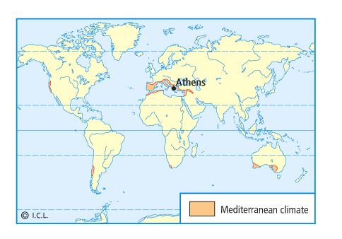
20 06 4. Oceanic and continental landscapes 4.1. Oceanic landscapes 4.2. Humans and the environment 4.3 Continental landscapes 4.4. Humans and the environment The oceanic and continental climates
21 4.1. Oceanic landscapes Oceanic landscapes are along the coastline between latitudes 40 and 60, north and south of the equator. The ocean causes mild temperatures. Rainfall is light and regular. Rivers have a high, regular flow throughout the year. Meadows are the most common form of vegetation. Other types of vegetation include deciduous forests and moors. Mammals such as bears, foxes and wild boars live in the forests. Small rodents like mice live on the moors.
22 4.2. Humans and the environment In Western Europe, forests have been cut down to make pastures for livestock or fields for crops, such as corn and potatoes. In North America, southern Chile and Argentina, there are still many forests. In Australia and New Zealand, there is a lot of grassland, allowing for extensive livestock.
23 4.3. Continental landscapes Continental landscapes are in the interior of Europe, Asia and North America. Temperatures are extreme with hot summers and cold winters. Precipitation is scarce. Although there is little rain, rivers have a high flow. In the north, the most common vegetation is taiga with pine, fir, larch and birch trees. In the south, there are extensive grasslands such as steppes and prairies. Common fauna in coniferous forests include deer, moose, squirrels and hares.
24 4.4. Humans and the environment The trees of the taiga are used to make cellulose, which is then made into paper. The steppes are used for raising livestock and growing cereals.

25 The oceanic and continental climates
26 5. The Mediterranean landscape 5.1. The Mediterranean landscape 5.2. Humans and the environment The Mediterranean climate
27 5.1. The Mediterranean landscape The Mediterranean landscape is found on the coasts of the Mediterranean Sea, California, central Chile, South Africa and southern and southwest Australia. Summers are hot and winters are mild because of the proximity to the sea. Rivers have a low, irregular flow. Mediterranean forests are made up of evergreen trees such as pines and holm oaks. Grazing by animals as well as forest fires are causing forests to disappear. In their place, there is maquis and garrigue shrubland.
28 5.2. Humans and the environment Areas with a steep relief, poor soil and little water have been converted into dryland farming areas for cereals, grapes and olives. The construction of canals and dams has allowed for irrigated farming to grow fruits and vegetables. Vegetables like peppers, fruits like strawberries and flowers are grown in greenhouses.
29 The Mediterranean climate


30 06 6. Europe s climates and landscapes 6.1. The diverse climates and landscapes of Europe 6.2 European vegetation and fauna The climates and landscapes of Europe
31 6.1. The diverse climates and landscapes of Europe The wide variety of climates and landscapes in Europe is mainly due to three factors: latitude, the influence of the sea and the relief. Most of the continent is between latitudes 35 N and 60 N. This means that Europe has temperate climates (continental, oceanic and Mediterranean). The proximity of Europe to the sea results in mild temperatures and abundant precipitation. The predominance of western-facing plains in Europe causes high humidity and rain.
32 6.2. European vegetation and fauna Tundra is the vegetation in Northern Europe. To the south there are coniferous forests. In the rest of the continent, the indigenous vegetation has disappeared due to human activity. As a result of human intervention, there are fewer large mammals than before. Small mammals in Europe include rabbits, hares and squirrels.

33 06 The climates and landscapes of Europe

34 7. Spain s climates and landscapes 7.1. The wide variety of climates in Spain Spain s climates and landscapes
35 7.1. The climates and landscapes of Spain On the Iberian Peninsula, we can find the three different types of temperate climates as well as the mountain climate. The climates on the Peninsula are different from those of the rest of Europe for three reasons: geographical location, the influence of the sea and the relief, and altitude. The Iberian Peninsula is closer to the tropical zone than the polar zone. The sea creates a mild climate, but the mountains prevent the sea from influencing inland areas. The average altitude of the Peninsula is quite high.

36 Spain s climates and landscapes
Chapter 20. The Physical Geography of Africa South of the Sahara
 Chapter 20 The Physical Geography of Africa South of the Sahara Chapter Objectives Identify the major landforms, water systems, and natural resources of Africa south of the Sahara. Describe the relationship
World Geography Ch. 7.2 Climate Regions of Latin America
 World Geography Ch. 7.2 Climate Regions of Latin America BR: D10 When you think of Latin America, what types of climates do you think are down there? Write down which of the following you believe are there:
Chapter 14. The Physical Geography of Russia
 Chapter 14 The Physical Geography of Russia Chapter Objectives Identify the physical features and natural resources of Russia. Discuss the effects of Russia s climate and vegetation on life in the region.
CH. 1 Europe and Russia: Physical Geography. Section 1 Land and Water p Europe and Russia are part of the world s largest landmass called.
 CH. 1 Europe and Russia: Physical Geography Section 1 Land and Water p.10-16 Europe and Russia are part of the world s largest landmass called. The country of Russia stretches over both continents. About
STUDY GUIDE. The Land. Physical Features of Latin America. Chapter 8, Section 1. Terms to Know DRAWING FROM EXPERIENCE ORGANIZING YOUR THOUGHTS
 For use with textbook pages 193 198. The Land Terms to Know cordillera A mountain range that runs parallel to another mountain range (page 194) altiplano A high plain (page 194) escarpment A steep cliff
Latin America. Introduction
 Latin America Introduction What are the 5 Themes of Geography? Draw lines to connect the theme to the definition: Location How humans and the environment impact each other Physical and human characteristics
Portuguese Language - Fostering National Unity
 Geography Brazil Brazil Portuguese Language - Fostering National Unity 11 dialects of Portuguese Influenced by Amerindian and African languages, creating differences between Portuguese spoken in Brazil
Terms to Know. artesian well coral atoll krill lagoon
 Chapter Objectives Describe the diverse landforms and natural resources of Australia, Oceania, and Antarctica. Discuss the wide range of climates and vegetation throughout the region. The Land Section
Chapter 17. North Africa, Southwest Asia and Central Asia
 Chapter 17 North Africa, Southwest Asia and Central Asia Chapter Objectives Describe the major landforms and natural resources of North Africa, Southwest Asia, and Central Asia. Discuss the climate and
UNIT 5 AFRICA PHYSICAL GEOGRAPHY SG 1 - PART II
 UNIT 5 AFRICA PHYSICAL GEOGRAPHY SG 1 - PART II III. CLIMATE & VEGETATION A. The four main climate zones are tropical wet, tropical wet/dry (split into monsoon & savanna), semiarid, and arid. Other climate
EXPLORING BIOMES IN GORONGOSA NATIONAL PARK
 EXPLORING BIOMES IN GORONGOSA NATIONAL PARK ABOUT THIS WORKSHEET This worksheet complements the Click and Learn Gorongosa National Park Interactive Map (http://www.hhmi.org/biointeractive/gorongosa-national-park-interactive-map),
STUDY GUIDE. The Land. Chapter 17, Section 1. There are frequent earthquakes in the region. Petroleum is a major export in the region.
 For use with textbook pages 421 426. The Land Terms to Know alluvial soil A rich soil made up of sand and mud deposited by flowing water (page 423) wadi A streambed that remains dry until a heavy rain
The Lesser Antilles. Dominican Republic), and Puerto Rico
, and Puerto Rico") The Caribbean Islands are archipelagoes or groups of islands. The major archipelagoes are: The Greater Antilles - Cuba, Jamaica, Hispaniola (Composed of Haiti and the Dominican Republic), and Puerto Rico
The Caribbean Islands are archipelagoes or groups of islands. The major archipelagoes are: The Greater Antilles - Cuba, Jamaica, Hispaniola (Composed of Haiti and the Dominican Republic), and Puerto Rico
Latin America. Physical Geography
 + Latin America Physical Geography + I. Landforms A. Caribbean & Central America 1. Mexico is dominated by two mountain chains, collectively called the Sierra Madre. A high plateau is situated in between.
Label your Map with Russia. Map Activity
 Bell Activity How many time zones does the U.S. have? How do these time zones affect life in the U.S.? Russia is so large it has 11 time zones. What difficulties might this create? Objectives Know landforms,
The Geological Pacific Northwest. Wednesday February 6, 2012 Pacific Northwest History Mr. Rice
 The Geological Pacific Northwest Wednesday February 6, 2012 Pacific Northwest History Mr. Rice 1 Free Response #2 Please do not simply list the items for this response. Full sentences!!! Minimum of 3-5
SS7G1 The student will locate selected features of Africa.
 Standards SS7G1 The student will locate selected features of Africa. a. Locate on a world and regional political-physical map: the Sahara, Sahel, savanna, tropical rain forest, Congo River, Niger River,
A funny sounding lake. South American Landforms, Climate, and Vegetation
 A funny sounding lake South American Landforms, Climate, and Vegetation 3 4 Essential Question: How have physical features and climate affected the population distribution of Latin America? 5 I. Landforms
AFRICAN PHYSICAL GEOGRAPHY
 AFRICAN PHYSICAL GEOGRAPHY Here are some factoids about Africa: world s second largest continent (11,700,000 miles). Home to 52 countries, 1,000 languages, 800 million people. 10% of the world s population
Geographic Qualities of South America
 Geographic Qualities of South America 1. South America is the fourth largest continent in area. It is located in the Western Hemisphere, lying southwest of North America. Most of South America lies in
Chapter 7 Geography and the Early Settlement of Egypt, Kush, and Canaan
 Chapter 7 Geography and the Early Settlement of Egypt, Kush, and Canaan How did geography affect early settlement in Egypt, Kush, and Canaan? Section 7.1 - Introduction RF/NASA//Corbis This satellite photograph
Colorado Life Zone Scavenger Hunt
 Colorado Life Zone Scavenger Hunt Below are worksheets created for all the habitats or life zones. They were designed with the intention of breaking the class up into small groups, and having students
STUDY GUIDE. The Land. Chapter 20, Section 1. The Land of Africa South of the Sahara. Landforms Water Systems Natural Resources.
 For use with textbook pages 499 504. The Land Terms to Know escarpment A steep, often jagged slope or cliff (page 500) cataract A towering waterfall (page 500) rift valley A large crack in the earth s
Brain Wrinkles. Africa: The impact of location, climate, & physical characteristics on where people live, the type of work they do, & how they travel
 Africa: The impact of location, climate, & physical characteristics on where people live, the type of work they do, & how they travel STANDARDS: SS7G3 The student will explain the impact of location, climate,
Latin America. Chapter 9 Physical Geography
 Latin America Chapter 9 Physical Geography Latin American Regions Middle America includes Mexico and the Central American countries The Caribbean Islands South America Mexico Landforms Sierra Madre Oriental
Essential Questions. 1. How have historical figures and events affected South America today?
 South America Essential Questions 1. How have historical figures and events affected South America today? 2. How has location affected the development of countries in South America? 3. How has the role
Introduction to Africa
 Introduction to Africa Did you know? Africa has more countries than any other continent. The Sahara is a desert that is the size of the U.S. It s the world's largest desert. Most of the world s gold and
Chapter Objectives. Describe the dominant landforms and natural resources of Southeast Asia. Discuss Southeast Asia s climate and vegetation.
 Chapter Objectives Describe the dominant landforms and natural resources of Southeast Asia. Discuss Southeast Asia s climate and vegetation. The Land Section 1 Objectives Describe how tectonic plates and
Just how big is Africa?
 The United States China India The United Kingdom Portugal Spain France Belgium Germany The Netherlands Switzerland Italy Eastern Europe Japan 11.7 million sq. miles Just how big is Africa? Chapter 18 Section
Chapter 7. Geography and the Early Settlement of Egypt, Kush, and Canaan
 Chapter 7 Geography and the Early Settlement of Egypt, Kush, and Canaan Chapter 7 Geography and the Early Settlement of Egypt, Kush, and Canaan How did geography affect early in Egypt Kush, and Canaan?
Oceania. Australia, New Zealand, and the Pacific Islands. Physical Geography. Where is Australia located?
 Oceania Australia, New Zealand, and the Pacific Islands Physical Geography Australia New Zealand Oceania Where is Australia located? Australia & Oceania are a group of islands located between Asia, Antarctica,
South American Countries. Capital Location Population Terrain Climate
 South American Countries Capital Location Population Terrain Climate Andes Mountains Four large areas that make up the Central Plains: Llanos, the Selva, the Gran Chaco, and the Pampas Brazilian Highlands
Chapter 7: The Geography and Settlement of Egypt, Kush, and Canaan
 Chapter 7: The Geography and Settlement of Egypt, Kush, and Canaan Learning Target: I can explain how geography affected early settlement in Egypt, Kush, and Canaan. Ancient Egypt and the Middle East Can
So far, you have looked at grasslands and three different
 Chapter Seven: Page 54 So far, you have looked at grasslands and three different types of forests: deciduous, coniferous and tropical rain forests. Now you will study two more biomes: and ( tun-dur-ah
Brain Wrinkles. Location, Climate, & Natural Resources of. Where People Live & How They Trade
 Location, Climate, & Natural Resources of Where People Live & How They Trade It s south of the US, east of the Pacific Ocean, and west of the Gulf of Mexico & Caribbean Sea. It s great that it s located
Latin America. Physical Geography
 Latin America Physical Geography Regions Latin America can be divided into separate regions based on physical geography or cultural geography. Regions If we look at physical geography Latin America has
Friday, November 10, 2017
 Friday, November 10, 2017 Andes and Midlatitude Countries Objective: Summarize the main physical features and regions of the Southern Cone. Identify and locate the urban centers and understand the pattern
LIFE IN THE DESERTS. Desert is a dry place having GEOGRAPHY. Chapter
 Chapter 9 LIFE IN THE DESERTS Unit-1 : OUR ENVIRONMENT GEOGRAPHY 72 Desert is a dry place having very little rainfall resulting in scarce vegetation. It has extreme temperatures high or low. Depending
STANDARDS: Brain Wrinkles
 STANDARDS: SS6G3 The student will explain the impact of location, climate, distribution of natural resources, and population distribution on Latin America and the Caribbean. a. Compare how the location,
South America. pg. 520 (5 th) pg. 523 (6 th )
 pg. 523 (6 th )") South America pg. 520 (5 th) pg. 523 (6 th ) Venezuela Rich in Oil Lake Maracaibo Called Little Venice pg. 572 (5 th) pg. 574 (6 th ) Caracas 8 miles Inland 3000 pg. 572 (5 th) pg. 574 (6 th ) Caracas
South America pg. 520 (5 th) pg. 523 (6 th ) Venezuela Rich in Oil Lake Maracaibo Called Little Venice pg. 572 (5 th) pg. 574 (6 th ) Caracas 8 miles Inland 3000 pg. 572 (5 th) pg. 574 (6 th ) Caracas
*Latin America spans 7,000 miles, from Mexico to Tierra Del Fuego. *3 Regions: Central America, South America, and the Caribbean.
 Physical Geography Latin America spans 7,000 miles, from Mexico to Tierra Del Fuego *3 Regions: Central America, South America, and the Caribbean. *Intro clip: http://www.youtube.com/watch?v=cffp6rza3
3rd GRADE MINIMUM CONTENTS UDI 1: LANDSCAPES (5)
") 3rd GRADE MINIMUM CONTENTS UDI 1: LANDSCAPES (5) DIFFERENT LANDSCAPES A landscape is all the things that we see in a place. There are different types of landscapes. Mountain landscapes have mountains and
3rd GRADE MINIMUM CONTENTS UDI 1: LANDSCAPES (5) DIFFERENT LANDSCAPES A landscape is all the things that we see in a place. There are different types of landscapes. Mountain landscapes have mountains and
South Texas Plains. Texas, Our Texas
 South Texas Plains This is a region characterized by considerable variety. Climatically, the South Texas Plains region is sub-humid to dry. The in the north part of the South Texas, erosion of the Edwards
Geography (cont) Sorghum, rice, millet, rice, wheat and corn grown on savannahs. Not just one big plain though mountainous and swampy areas too
 Sorghum, rice, millet, rice, wheat and corn grown on savannahs. Not just one big plain though mountainous and swampy areas too") Geography & Society in Africa: 500 BCE-900 CE Geography Around 5000 miles wide and long Various climates, jungles, snow-capped mountains, deserts and rain-soaked areas. 40% desert - largely uninhabitable
Geography & Society in Africa: 500 BCE-900 CE Geography Around 5000 miles wide and long Various climates, jungles, snow-capped mountains, deserts and rain-soaked areas. 40% desert - largely uninhabitable
2.1 What is the climate like?
 José Medeiros This fact sheet allows you to see how varied the countryside is across Brazil. 2.1 What is the climate like? Most of Brazil is in the Southern Hemisphere, where the seasons are the opposite
MCGRAW-HILL EUROPE. Chapter 11 Physical Geography Pages 332 to 341
 MCGRAW-HILL EUROPE Chapter 11 Physical Geography Pages 332 to 341 Countries of Western Europe Benelux Countries UK, France, Luxembourg, Germany, Netherlands, Belgium, Austria, Switzerland, Belgium, Monaco,
CHAPTER 12. South America. Section 1: Natural Environments Section 2: History and Culture Section 3: South America Today. HOLT World Geography
 CHAPTER 12 South America Section 1: Natural Environments Section 2: History and Culture Section 3: South America 1 Section 1 Natural Environments Objectives: What are the major landforms and rivers of
Academic Vocabulary Social Studies, 5-8 (adapted from Building Academic Vocabulary by Robert Marzano.)
") Academic Vocabulary Social Studies, 5-8 (adapted from Building Academic Vocabulary by Robert Marzano.) Provide a student-friendly description, explanation, or example of the term. 7 Continents of the World
Academic Vocabulary Social Studies, 5-8 (adapted from Building Academic Vocabulary by Robert Marzano.) Provide a student-friendly description, explanation, or example of the term. 7 Continents of the World
Objective. Students will familiarize themselves with the physical features and climates of Latin America.
 Journal Write KWL What do you KNOW about Latin America? What do you WANT TO KNOW about Latin America? What did you LEARN today that you didn t know before? Latin America Objective Students will familiarize
STUDY GUIDE. The Land. Chapter 29, Section 1. Both. Terms to Know DRAWING FROM EXPERIENCE ORGANIZING YOUR THOUGHTS
 Chapter 29, Section 1 For use with textbook pages 719 724. The Land Terms to Know cordilleras Parallel mountain ranges and plateaus (page 719) archipelago A group of islands (page 720) insular Relating
G.H.S. GEOGRAPHY PAPER 2 S. 3 TIME: 2 Hours NOV. 2012
 G.H.S. GEOGRAPHY PAPER 2 S. 3 TIME: 2 Hours NOV. 2012 Answer three questions in all. Two questions should be answered from Part I and one question from Part II PART I 1. (a) Draw a sketch map of Africa
SRC 2010: JUNGLE BINGO Words
 SRC 2010: JUNGLE BINGO Words B Adventure B Ape B Binoculars B Boa Constrictor B Camp B Canteen B Cougar B Danger B Ecosystem B Elephant B Forest B Guides B Habitat B Jeep B King B Knife B Madagascar B
EUROPEAN COMMISSION DG XI.D.2. COUNCIL DIRECTIVE 79/409/EEC on the conservation of wild birds. and
 EUROPEAN COMMISSION DG XI.D.2 COUNCIL DIRECTIVE 79/409/EEC on the conservation of wild birds and COUNCIL DIRECTIVE 92/43/EEC on the conservation of natural habitats and of wild fauna and flora STANDARD
Monday, December 11, 2017
 Monday, December 11, 2017 Physical Geography of Russia Objective: complete Warm-Up, write outline notes and discuss the geography of Eastern Europe/mother Russia and view Geography Now: Belarus. География
UNIT 5 PHYSICAL GEOGRAPHY SG 1 - PART I
 UNIT 5 PHYSICAL GEOGRAPHY SG 1 - PART I Africa is HUGE! I. LANDFORMS A. Plateaus - an area of relatively level high ground. 1. Africa s interior is dominated by series of plateaus and elevated basins such
Chapter 13: Life in the Central Andes- Adapting to a Mountainous Region
 Chapter 13: Life in the Central Andes- Adapting to a Mountainous Region 1. Introduction La Paz, Bolivia, is the highest big city in the world, sitting at 12,000 feet above sea level in the central Andes
WORLD GEOGRAPHY. Hector Rodriguez
 Mr. Chavira 9th Period WORLD GEOGRAPHY Hector Rodriguez P a g e 1 Table of Contents Latin America Page 2 o Maps Economic Map Page 3 Political Map Page 4 Population Map Page 5 Physical Page 6 o Notes Physical
Unit 1. School Days. First Nine Weeks
 Study Buddy Unit 1 School Days First Nine Weeks Teacher- A person who helps us learn. Map- A drawing that shows where places are. Group- A number of people doing an activity together. Rule- What you must
Chapter 16 ~ Eastern Mediterranean
 Chapter 16 ~ Eastern Mediterranean Physical Geography of the Eastern Mediterranean Landforms This area is known as the Levant and includes Syria, Jordan, Lebanon, Israel, and the Palestinian territories.
Roduner Ranch FOR SALE. 5,878± Acres Potential Development Land. Merced County, California. Offices Serving The Central Valley
 FOR SALE 5,878± Acres Potential Development Land Merced County, California Offices Serving The Central Valley F R E S N O V I S A L I A B A K E R S F I E L D 7480 N. Palm Ave, Ste 101 3447 S. Demaree Street
Lecture #1: Introduction
 Anthropology G4210 The Rise of Andean Civilization T. D'Altroy September 8, 1999 Lecture #1: Introduction 1. purposes of the course a. examination of the nature and development of societies in the Andes
Chapter 16 ~ Eastern Mediterranean
 Chapter 16 ~ Eastern Mediterranean Physical Geography of the Eastern Mediterranean Landforms This area is known as the Levant and includes Syria, Jordan, Lebanon, Israel, and the Palestinian territories.
Africa: Physical geography
 Africa: Physical geography By National Geographic Society, adapted by Newsela staff on 09.15.17 Word Count 1,279 Level 1040L African elephants roam the savannas, which cover almost half of the African
Ancient Egypt and the Near East
 *O*»f ' i ft Ancient Egypt and the Near East Chapter 7 Chapter 8 Chapter 9 Geography and the Early Settlement of Egypt, Kush, and Canaan The Ancient Egyptian P h a r a o h s Daily Life in Ancient Egypt
Location, Climate, & Natural Resources Brain Wrinkles
 Location, Climate, & Natural Resources Standards SS6G10 The student will explain the impact of location, climate, natural resources, and population distribution on Europe. a. Compare how the location,
Geography of Qatar. Contents. State Borders. al-khor, Qatar. Photo Flickr. Loading index...
 Geography of Qatar al-khor, Qatar. Photo Flickr Contents Loading index... State Borders The small (sub)peninsula of Qatar is about 160 kilometres in length and between 55 and 90 kilometres in width. Its
2015 Brain Wrinkles. SS8G1b
 SS8G1b Georgia is a geographically diverse state that is divided into five regions. The first three regions (Appalachian Plateau, Valley and Ridge, and Blue Ridge) are in the mountains and foothills of
Chapter 2A: The Russian Realm
 Geography: Realms, Regions, and Concepts 16 th Edition Chapter 2A: The Russian Realm The Russian Realm Two transition zones mark the margins. The Russian Realm Two transition zones mark the margins. Physical
1. Landforms. The Boreal Shield. Location The Boreal Shield can be found from Alberta to Newfoundland, between the Taiga Shield and the Boreal Plains.
 The Boreal Shield Location The Boreal Shield can be found from Alberta to Newfoundland, between the Taiga Shield and the Boreal Plains. 1. Landforms Rolling hills Exposed bedrock Evidence of glacial weathering
ALBERTA S GRASSLANDS IN CONTEXT
 ALBERTA S GRASSLANDS IN CONTEXT GLOBAL GRASSLANDS 1 Temperate grasslands, located north of the Tropic of Cancer and south of the Tropic of Capricorn, are one of the world s great terrestrial biomes 2.
Brazil. Chapter 12. Chapter 12, Section
 Chapter 12, Section World Geography Chapter 12 Brazil Copyright 2003 by Pearson Education, Inc., publishing as Prentice Hall, Upper Saddle River, NJ. All rights reserved. Chapter 12, Section World Geography
6th Grade Third Nine Weeks Benchmark Assessment
 6th Grade Third Nine Weeks Benchmark Assessment Multiple Choice Identify the choice that best completes the statement or answers the question. Key Concepts 1 Latin America is located in the A Northern
SS8G1 The student will describe Georgia with regard to physical features and location.
 SS8G1ab Standards SS8G1 The student will describe Georgia with regard to physical features and location. a. Locate Georgia in relation to the region, nation, continent, and hemispheres. b. Describe the
REPRODUCIBLE MATERIALS
 REPRODUCIBLE MATERIALS Tongass Rainforest by Flickr user Swanksalot In the Deser/Feeling Like Walking by Flickr user Horizon Lonely Island by Flickr user gari.baldi Bombed Hospital by Flickr user The Rocketeer
Location, Climate, & Natural Resources
 Location, Climate, & Natural Resources UK is a country of islands off the coast of mainland Europe. It consists of England, Northern Ireland, Scotland, & Wales. UK s location makes it a HUB for trade.
Latin America and The Caribbean. A Closer Look.
 Latin America and The Caribbean A Closer Look. Mexico Capital: Mexico City The Location of Mexico Mexico is the second-largest country by size and population in Latin America.but the Largest Spanish -
LOCATION, CLIMATE, AND NATURAL RESOURCES OF MEXICO
 SS6G3 The student will explain the impact of location, climate, distribution of natural resources, and population distribution on Latin America and the Caribbean. a. Compare how the location, climate,
6th Grade Social Studies Chapter 7: The Geography and Early Settlement of Egypt, Kush and Canaan
 I. Introduction (7.1) A. Egyptians settled along the Nile River, in the NE corner of Africa B. civilization lasted from around 3100 B.C. to 350 C. E. C. Kushites settled to the south of Egypt, along the
ARCTIC TUNDRA ELLA SABO, KINSEY SPERLING, GRACE ZOLKOWSKI
 ARCTIC TUNDRA ELLA SABO, KINSEY SPERLING, GRACE ZOLKOWSKI ARCTIC TUNDRA LOCATIONS The areas highlighted in blue are the areas where the biome is. Notice these areas are pretty far away from the equator,
Social Studies: The World
 Social Studies: The World What is the name of the continent that is labeled #1 on the map? North America What is the name of the continent that is labeled #2 on the map? South America What is the name
Crete Study Site Description
 Crete Study Site Description 1. Location Crete (the largest island of Greece) is located in the south part of Greece covering an area of 8.335 km 2 or 6.3% of the Greek territory, including the surrounding
ENVIRONMENTAL PROFILE:
 Pyrenees Study Area for LEDDRA LOCATION: The Pyrenees study area is located in the Spanish Central Pyrenees (42º 36 N, 0º 00 E), in the Sobrarbe area (Huesca province, Aragón region). It includes the municipalities
Africa s. Presentation, Graphic Organizers, & Activities
 Africa s Presentation, Graphic Organizers, & Activities STANDARDS: SS7G1 Locate selected features of Africa. a. Locate on a world and regional political-physical map: Sahara, Sahel, savanna, tropical rain
AGRITECH th December 2017, Podgorica
 AGRITECH 2017 06-07 th December 2017, Podgorica AGRI Potentials of Capital City Podgorica Vladimir Pavićević, MSc Deputy Secretary Secretariat for labor, youth and social care Main characteristics of Montenegro
North Africa. Chapter 25. Chapter 25, Section
 Chapter 25, Section World Geography Chapter 25 North Africa Copyright 2003 by Pearson Education, Inc., publishing as Prentice Hall, Upper Saddle River, NJ. All rights reserved. Chapter 25, Section World
ANZAC TERRACE PRIMARY SCHOOL
 ANZAC TERRACE PRIMARY SCHOOL SOCIETY & ENVIRONMENT Essential knowledge relevant to students in Western Australia within local, national, regional and global contexts. Phases of Development - Early Childhood
The Geography of Climate
 The Geography of Climate Objective for Today: Today we will examine ways that latitude and landforms influence climate The focus of our study will be the South American Continent in the Formal Region known
North Africa and Southwest Asia. Economic Geography
 North Africa and Southwest Asia Economic Geography Natural Resources Oil is the major resource in this region. Many countries in this region are members of OPEC (Organization of Petroleum Exporting Countries).
Unit 1: Physical Geography Notes
 - How has the physical world impacted settlement patterns? o Major factors in the decision-making process of o Before the boom controlling the physical environment was not possible on a large scale - Physical
Physical Regions of the U.S.
 Physical Regions of the U.S. Quickly use this map to label the map on your paper Pacific Coast The coast from southern California to Alaska The region of the Pacific Northwest has a long history that was
1st Period Mr. Chavira WORLD GEOGRAPHY. Hector Rodriguez
 1st Period Mr. Chavira WORLD GEOGRAPHY Hector Rodriguez P a g e 1 Table of Contents Latin America Page 2 o Maps Economic Map Page 3 Political Map Page 4 Population Map Page 5 Physical Page 6 o Notes Physical
Do Not Write On This Sheet. World Rally. City, country, continient: to city, country, continent:
 World Rally At each checkpoint you must list the city, country, and continent. The teacher must check all answers before you can go on to the next checkpoint. Checkpoint 1: Start at: 29 N 98 W and go to:
"ST. KLIMENT OHRIDSKI FACULTY OF GEOLOGY AND GEOGRAPHY
 SOFIA UNIVERSITY "ST. KLIMENT OHRIDSKI FACULTY OF GEOLOGY AND GEOGRAPHY APPLICATION OF THE MODEL "DRIVING FORCES PRESSURE STATE - RESPONSE FOR ASSESSMENT OF FLOOD RISK RADOSTINA BORISOVA DOCHEVA Bachelor
Chapter 21: EAST AFRICA
 Chapter 21: EAST AFRICA Physical Geography of East Africa Landforms East Africa is a diverse landscape of different plains, volcanic mountains, and plateaus cut by a large valley and marked by many rivers
LATIN AMERICA. Mexico Central America Caribbean Islands South America
 LATIN AMERICA Mexico Central America Caribbean Islands South America HISTORY First Settlers Hunters/gatherers from Asia crossed land bridge connecting Asia and Alaska Learned to farm over time Maize (corn)
Middle East Part I Notes
 Middle East Part I Notes What do we already know about the Middle East? What do we already know about the Middle East? Pre-Test 1. T/F- The U.S. is currently fighting a war in the Middle East. 2. Which
Mrs. Reifsnyder World Geography. Unit 8: Latin America Study Guide SOLs Addressed: WG. 1c, 2b, 3c, 4, 10b/c
 Mrs. Reifsnyder World Geography Unit 8: Latin America Study Guide SOLs Addressed: WG. 1c, 2b, 3c, 4, 10b/c Essential Questions: - In what ways do physical, economic, and cultural characteristics influence
Lesson 1: Land and Climate of the West Land and Water of the West 1. There are 13 states in the West, divided into 3 regions a. Southwest: Nevada,
 Lesson 1: Land and Climate of the West Land and Water of the West 1. There are 13 states in the West, divided into 3 regions a. Southwest: Nevada, Utah, Arizona, New Mexico b. Mountain States: Wyoming,
LOCATION, LOCATION, LOCATION! Mexico, Venezuela, Cuba, and Brazil
 LOCATION, LOCATION, LOCATION! Mexico, Venezuela, Cuba, and Brazil GPS and E.Q. GPS: SS6G3 The student will explain the impact of location, climate, distribution of natural resources, and population distribution
3 rd Term Worksheet [ ] Subject Geography Class VI Name : Sec. :
![3 rd Term Worksheet [ ] Subject Geography Class VI Name : Sec. :](/thumbs/84/89736232.jpg "3 rd Term Worksheet [ ] Subject Geography Class VI Name : Sec. :") 1 geo (vi) 3 rd Term Worksheet [2018 19] Subject Geography Class VI Name : Sec. : Case Study 1 : The Lumberjacks of Canada Exercise: [80-81] [A] Choose the correct answers: [80] 1. What are the men who
1 geo (vi) 3 rd Term Worksheet [2018 19] Subject Geography Class VI Name : Sec. : Case Study 1 : The Lumberjacks of Canada Exercise: [80-81] [A] Choose the correct answers: [80] 1. What are the men who