Rivers. Highlights of some of the World s Most Famous Rivers!
|
|
|
- Frederica Mills
- 5 years ago
- Views:
Transcription

1 Rivers Highlights of some of the World s Most Famous Rivers!
2 Directions This Power Point presentation contains information about some of the most famous rivers in the world! Students should use this presentation to help them with their rivers project! Remember, consider the manner in which these rivers affect their regions and the people who inhabit them (Human Environment Interaction) All information has been taken from our course textbook.
 Pictured right is the Charles River, the longest river located entirely in Massachusetts at")
3 What Are Rivers? River: a natural flow of water that runs through the land (p.h10) Pictured right is the Charles River, the longest river located entirely in Massachusetts at approximately 80 miles long!
4 Essential Question List 2-3 reasons that might explain why the earliest human settlements chose to live near rivers?

5 Why Are Rivers Important? The Case of Ancient India! An Ancient Empire existed in modern India near the Indus River Valley from 3500 BCE BCE This civilization may have had a population of up to 5 million people! Harappa and Mohenjo Daro were the two most significant urban centers which have been excavated by archaeologists This Empire extended from the Himalayas to the Arabian Sea and included: Trade networks Systems of government Cities with paved roads and The world s first sewer system! By 1500 BCE this civilization was gone! Where did it go?

6 Decline of the Indus River Civilization: 1500 BCE One theory which may explain the decline of the Empire involves climate change Modern satellite imagery confirms the remains of an ancient river bed which dried up around 1500 BCE It is possible that the shifting of this river forced migration towards the Ganges River plain, thus ending the Indus River civilization

7 The Great Rivers of the World! (The Shannon River in Ireland, pictured below)

8 Rivers of the Atlantic South American Region: The Amazon River The Amazon River World s largest river system Flows eastward across Northern Brazil About 4,000 miles long Contains about 20% of all water that runs off the Earth s surface Images of the Amazon on the next slide!
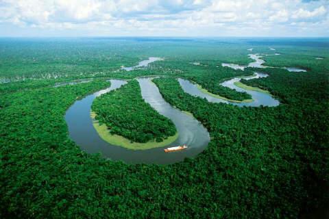
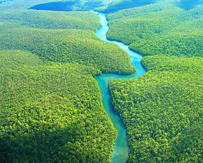
9

10 The Parana River Drains much of central South America Flows into Rio de la Plata and the Atlantic ocean The Rio de la Plata is an estuary Estuary- a partially enclosed body of water where freshwater mixes with salty seawater

11 Iguazu Falls: Part of the Parana River
12 Essential Question Locate the Rio de la Plata estuary Based on the location of this estuary, why does it make sense that an estuary combines salt water and fresh water?
13

14 Rivers of Caribbean South America Region: Orinoco River Region s Largest River Flows from Venezuela through the Atlantic Ocean
 Impossible for ships to travel from interior of Cent.")
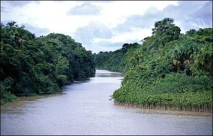
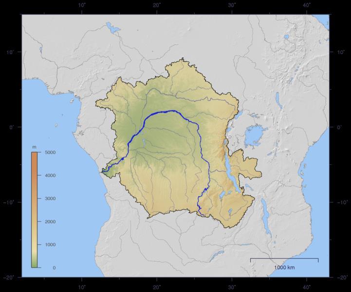
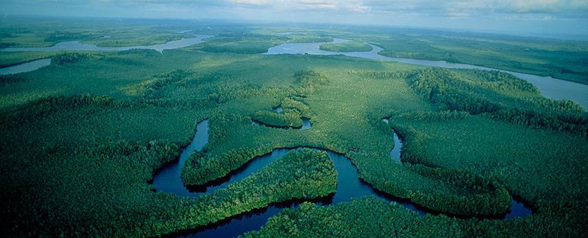
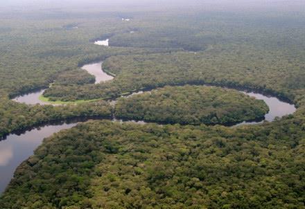
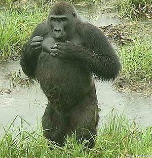
15 Rivers of Central African Region: The Congo River Hundreds of smaller rivers drain Congo basin and flow into Congo river River empties into Atlantic Ocean Many rapids and waterfalls (especially near mouth) Impossible for ships to travel from interior of Cent. Africa to Atlantic Important transportation route in interior of continent Images of the rapids and waterfalls
16
17
18

19 Congo River Basin Landform Congo Basin Basin: a flat region surrounded by higher land such as mountains and plateaus Plateaus and low hills surround the Congo Basin List 3 adjectives to describe the Congo River Basin Images:
20
21
22
23

24 Flows eastward toward the Indian Ocean Most famous for: Victoria Falls List 3 adjectives to describe the Victoria Falls Zambezi River
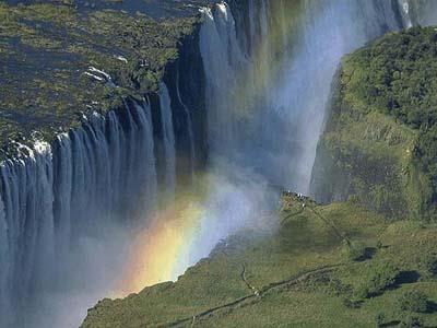
25
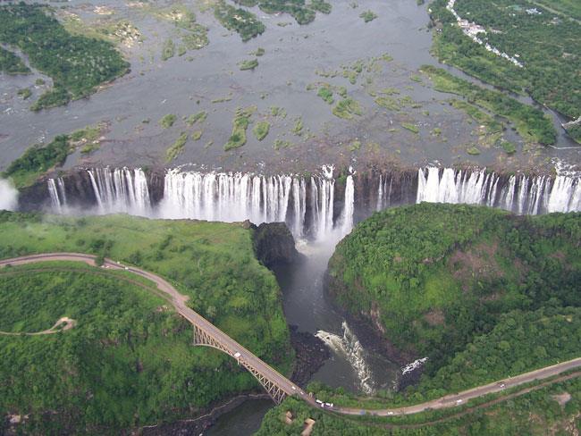
26

27 Shallow rock pool near edge of falls Safe for swimming during September and December h?v=0dq8pr2t6hq Devil s Pool

28 Rivers of the Western African Region: The Niger River Region s most important river Starts in low mountains near Atlantic Flows 2,600 miles, empties into Gulf of Guinea
 River floods in rainy")
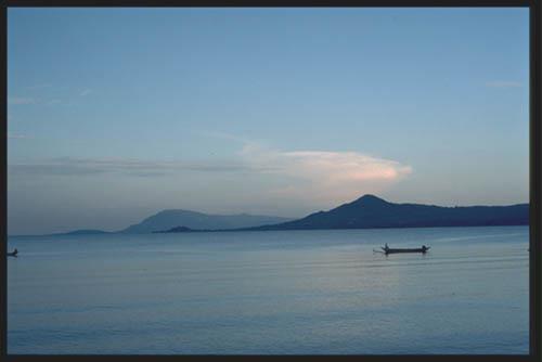
29 Life along the Niger Provides life giving water to region Many people farm and fish Important transportation route (especially in rainy season) River floods in rainy season

30 Rivers of the Northern African Region: The Nile River World s Longest River Formed by the Blue and White Nile Flows Northward through Eastern Sahara Over 4,000 miles long Empties into Mediterranean Sea

31

32 Life Near the Nile River For centuries rain to the far South caused floods along Northern Nile Floods left rich silt in surrounding field Silt: finely ground fertile soil that is good for growing crops

33 Life Near the Nile River (cont) Farmers use water from the Nile to irrigate fields Like an Oasis in the Desert Nile forms large Delta near Med Sea Delta: landform at mouth of river that is created by deposit of sediment Sediment from Nile makes soil extremely fertile for farming

34 The Nile River Allowed Ancient Egypt to develop into a Highly Advanced Civilization

35 Impact of the Nile: The Aswan High Dam! Completed in 1970 Controls flooding along the Nile However, dam also traps silt! Today, some of Egypt s farmers must use fertilizer to enrich soil!

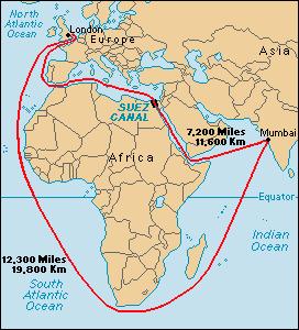
36 Building project related to the Nile: The Suez Canal Built in the 1860s by the French Narrow waterway connecting the Mediterranean sea and the Red Sea Large Cargo ships carry oil and trade goods through the Suez Canal
37 Essential Question Based on the Map, list 2 reasons why closure of the Suez canal would hurt trade between Europe and Asia?
38
39 The Nile River & Lake Victoria Lake Victoria Africa s Largest Lake White Nile river is formed by water that flows into Lake Victoria Some Lakes in the region are too hot for swimming! Images of Lake Victoria include:
40 Lake Victoria (Satellite)
41

42 Rivers of the Southern African Region 3 major rivers: Okavango Orange Limpopo Okavango s water never reaches ocean Forms a swampy inland delta, home to: Crocodiles, Zebras and Hippos

43 Augrabies Falls Orange River passes through Augrabies Falls 19 separate waterfalls Limpopo river flows into Indian Ocean Waterfalls block ships from entering rivers Plenty of water to irrigate farmland
44 Huang He or Yellow River Flows across Northern China Picks up large amounts of loess along the way Loess: Fertile yellowish soil Soil colors the river yellow, hence: The Yellow River! Rivers of Asia: China

45 Huang He River: Impact Huang He often floods in the summer Floods enrich soil with loess but: Between the years million people died in floods Due to floods, Huang He is also known as: China s Sorrow 1931 flood: Killed between million people
46 Chang Jiang or Yangzi River Chang Jiang or Yangzi River Flows across Central China Asia s Longest River Major Transportation Route Essential Question: List 2 ways that living along these 2 rivers can affect life for the local population

47 Rivers of Asia: India The Ganges River 1,560 Miles Long Rises in the Himalayas Mountains and empties into the Bay of Bengal Supports hundreds of millions of people! Also very important religiously and spiritually for the native Indian religion of Hinduism

48 The Ganges River
49 Sources: Images: 7uotUE/s1600/ c9.png "Athlone" by Ingo Mehling - Own work. Licensed under CC BY-SA 3.0 via Commons "Varanasiganga" by Babasteve &size=o. Licensed under CC BY 2.0 via Commons - Information: Course Textbook
Ancient Egypt. Life Along the Nile River
 Ancient Egypt Life Along the Nile River 2018 Geography How Does Geography affect the way that people live? Geography- Where in the World? You are Here Streetsboro, Ohio United States of America Geography-
Chapter 20. The Physical Geography of Africa South of the Sahara
 Chapter 20 The Physical Geography of Africa South of the Sahara Chapter Objectives Identify the major landforms, water systems, and natural resources of Africa south of the Sahara. Describe the relationship
Chapter 17. North Africa, Southwest Asia and Central Asia
 Chapter 17 North Africa, Southwest Asia and Central Asia Chapter Objectives Describe the major landforms and natural resources of North Africa, Southwest Asia, and Central Asia. Discuss the climate and
UNIT 5 PHYSICAL GEOGRAPHY SG 1 - PART I
 UNIT 5 PHYSICAL GEOGRAPHY SG 1 - PART I Africa is HUGE! I. LANDFORMS A. Plateaus - an area of relatively level high ground. 1. Africa s interior is dominated by series of plateaus and elevated basins such
Just how big is Africa?
 The United States China India The United Kingdom Portugal Spain France Belgium Germany The Netherlands Switzerland Italy Eastern Europe Japan 11.7 million sq. miles Just how big is Africa? Chapter 18 Section
Ancient Egypt and the Near East
 *O*»f ' i ft Ancient Egypt and the Near East Chapter 7 Chapter 8 Chapter 9 Geography and the Early Settlement of Egypt, Kush, and Canaan The Ancient Egyptian P h a r a o h s Daily Life in Ancient Egypt
AFRICAN PHYSICAL GEOGRAPHY
 AFRICAN PHYSICAL GEOGRAPHY Here are some factoids about Africa: world s second largest continent (11,700,000 miles). Home to 52 countries, 1,000 languages, 800 million people. 10% of the world s population
Chapter 7 Geography and the Early Settlement of Egypt, Kush, and Canaan
 Chapter 7 Geography and the Early Settlement of Egypt, Kush, and Canaan How did geography affect early settlement in Egypt, Kush, and Canaan? Section 7.1 - Introduction RF/NASA//Corbis This satellite photograph
6th Grade Social Studies Chapter 7: The Geography and Early Settlement of Egypt, Kush and Canaan
 I. Introduction (7.1) A. Egyptians settled along the Nile River, in the NE corner of Africa B. civilization lasted from around 3100 B.C. to 350 C. E. C. Kushites settled to the south of Egypt, along the
SS7G1 The student will locate selected features of Africa.
 Standards SS7G1 The student will locate selected features of Africa. a. Locate on a world and regional political-physical map: the Sahara, Sahel, savanna, tropical rain forest, Congo River, Niger River,
Mediterranean Sea Persian Gulf Red Sea Tigris River Euphrates River Sumer Fertile Crescent
 GEOGRAPHY MESOPOTAMIA MAP Mediterranean Sea Persian Gulf Red Sea Tigris River Euphrates River Sumer Fertile Crescent ACHIEVEMENT INTELLECT RELIGION POLITICS SOCIETY ECONOMY N Fertile Crescent - lots of
Chapter 7: The Geography and Settlement of Egypt, Kush, and Canaan
 Chapter 7: The Geography and Settlement of Egypt, Kush, and Canaan Learning Target: I can explain how geography affected early settlement in Egypt, Kush, and Canaan. Ancient Egypt and the Middle East Can
Introduction to Africa
 Introduction to Africa Did you know? Africa has more countries than any other continent. The Sahara is a desert that is the size of the U.S. It s the world's largest desert. Most of the world s gold and
Chapter 7. Geography and the Early Settlement of Egypt, Kush, and Canaan
 Chapter 7 Geography and the Early Settlement of Egypt, Kush, and Canaan Chapter 7 Geography and the Early Settlement of Egypt, Kush, and Canaan How did geography affect early in Egypt Kush, and Canaan?
Latin America. Chapter 9 Physical Geography
 Latin America Chapter 9 Physical Geography Latin American Regions Middle America includes Mexico and the Central American countries The Caribbean Islands South America Mexico Landforms Sierra Madre Oriental
Unit 6 vocabulary. Serengeti Plain
 basin Nile River rift valley Mount Kilimanjaro escarpment Sahara aquifer oasis Serengeti Plain canopy Niger delta Sahel the world s longest river, flowing more than 4,000 miles through Uganda and Sudan
North Africa. Chapter 25. Chapter 25, Section
 Chapter 25, Section World Geography Chapter 25 North Africa Copyright 2003 by Pearson Education, Inc., publishing as Prentice Hall, Upper Saddle River, NJ. All rights reserved. Chapter 25, Section World
STUDY GUIDE. The Land. Chapter 20, Section 1. The Land of Africa South of the Sahara. Landforms Water Systems Natural Resources.
 For use with textbook pages 499 504. The Land Terms to Know escarpment A steep, often jagged slope or cliff (page 500) cataract A towering waterfall (page 500) rift valley A large crack in the earth s
Unit 1: Physical Geography Notes
 - How has the physical world impacted settlement patterns? o Major factors in the decision-making process of o Before the boom controlling the physical environment was not possible on a large scale - Physical
Middle East Part I Notes
 Middle East Part I Notes What do we already know about the Middle East? What do we already know about the Middle East? Pre-Test 1. T/F- The U.S. is currently fighting a war in the Middle East. 2. Which
Unit 9 The Middle East SG 1 - Physical Geography, Population & Demographics
 Unit 9 The Middle East SG 1 - Physical Geography, Population & Demographics I. Physical Geography A. The Middle East includes southwestern Asia and North Africa. 1. The name is Eurocentric. Middle East
The Nile is the world s longest river. It is 4,160 miles long. It flows north and empties into the Mediterranean Sea
 The Nile is the world s longest river. It is 4,160 miles long It flows north and empties into the Mediterranean Sea Lower Egypt is at the Nile s mouth near the Mediterranean Sea. It is in Northern Egypt
CHAPTER 12. South America. Section 1: Natural Environments Section 2: History and Culture Section 3: South America Today. HOLT World Geography
 CHAPTER 12 South America Section 1: Natural Environments Section 2: History and Culture Section 3: South America 1 Section 1 Natural Environments Objectives: What are the major landforms and rivers of
STUDY GUIDE. The Land. Chapter 17, Section 1. There are frequent earthquakes in the region. Petroleum is a major export in the region.
 For use with textbook pages 421 426. The Land Terms to Know alluvial soil A rich soil made up of sand and mud deposited by flowing water (page 423) wadi A streambed that remains dry until a heavy rain
Latin America s Physical Geography. EQ: What are characteristics of Latin America s physical features?
 Latin America s Physical Geography EQ: What are characteristics of Latin America s physical features? Your Task: We are going to participate in a Museum Walk! You will travel around the room with a partner
Africa s. Presentation, Graphic Organizers, & Activities
 Africa s Presentation, Graphic Organizers, & Activities STANDARDS: SS7G1 Locate selected features of Africa. a. Locate on a world and regional political-physical map: Sahara, Sahel, savanna, tropical rain
1: The Nile River Valley
 1: The Nile River Valley In Nubia and Egypt, the Nile flows through the Sahara, a vast desert that stretches across most of northern Africa. Before reaching Egypt, the river in ancient times roared through
Vocabulary Words. predict inundation deity afterlife. mummy cataract nation-state dynasty
 The Gift of Nile Vocabulary Words predict inundation deity afterlife mummy cataract nation-state dynasty Predict Predict: To tell ahead of time what will happen. Inundation Inundation; Annual flooding
ì<(sk$m)=bdicij< +^-Ä-U-Ä-U
=bdicij< +^-Ä-U-Ä-U") Genre Comprehension Skill Text Features Science Content Nonfiction Compare and Contrast Captions Diagrams Rocks and Soil Labels Glossary Scott Foresman Science 3.7 ì
Genre Comprehension Skill Text Features Science Content Nonfiction Compare and Contrast Captions Diagrams Rocks and Soil Labels Glossary Scott Foresman Science 3.7 ì
1 o f 5. Name Period. Parent Signature
 Name Period Parent Signature DIRECTIONS: Write the definition on the line next to each of the vocabulary terms below. Then in the box, draw a picture that will help you remember the word and definition.
Ancient Egypt, Kush, and Israel
 500 1,000 miles T ER ES D N YA LIB 1 Geography and the Early Settlement of Egypt, Kush, and Canaan AFRICA NUBIAN DESERT ed 0 500 1,000 kilometers Sinusoidal (Sanson-Flamsteed) Projection S E ARABIAN PENINSULA
STUDY GUIDE. The Land. Physical Features of Latin America. Chapter 8, Section 1. Terms to Know DRAWING FROM EXPERIENCE ORGANIZING YOUR THOUGHTS
 For use with textbook pages 193 198. The Land Terms to Know cordillera A mountain range that runs parallel to another mountain range (page 194) altiplano A high plain (page 194) escarpment A steep cliff
Essential Standards: WH.H.2 Analyze ancient civilization and empires in terms of their development, growth and lasting impact.
 Unit: Ancient Civilizations Topic: The Nile River Valley Essential Standards: WH.H.2 Analyze ancient civilization and empires in terms of their development, growth and lasting impact. Clarifying Objectives:
Brain Wrinkles. Africa: The impact of location, climate, & physical characteristics on where people live, the type of work they do, & how they travel
 Africa: The impact of location, climate, & physical characteristics on where people live, the type of work they do, & how they travel STANDARDS: SS7G3 The student will explain the impact of location, climate,
Social Studies: The World
 Social Studies: The World What is the name of the continent that is labeled #1 on the map? North America What is the name of the continent that is labeled #2 on the map? South America What is the name
PHYSICAL GEOGRAPHY. Unit 1
 PHYSICAL GEOGRAPHY Unit 1 HOW HAS THE PHYSICAL WORLD IMPACTED SETTLEMENT PATTERNS? Major factor in the decision-making process of settlers Before the technological boom controlling the physical environment
Essential Questions. 1. How have historical figures and events affected South America today?
 South America Essential Questions 1. How have historical figures and events affected South America today? 2. How has location affected the development of countries in South America? 3. How has the role
Ancient River Valley Civilizations Egypt
 Ancient River Valley Civilizations Egypt Geography of Egypt The first civilization in Africa developed along the Nile River, in a place called Egypt. These humans were at first nomadic, also known as hunter-gatherers.
Ancient Egypt: an Overview
 Ancient Egypt: an Overview Timeline Old Kingdom Middle Kingdom 2650 BC 2134 BC 2125 BC 1550 BC New Kingdom 1550 BC 1295 BC http://www.thebanmappingproject.com/resources/timeline.html 1 Three Kingdoms of
Dawood Public School Course Outline Social Studies Class III
 1 Dawood Public School Course Outline 2014-15 Social Studies Class III Books: Mackay, Frances: Moorcroft, Christine. (2013). World Watch 3 and Work Book; Social studies for Primary schools. Oxford University
North Africa and Southwest Asia. Economic Geography
 North Africa and Southwest Asia Economic Geography Natural Resources Oil is the major resource in this region. Many countries in this region are members of OPEC (Organization of Petroleum Exporting Countries).
South, Southeast, and East Asia Physical Geography
 South, Southeast, and East Asia Physical Geography Mountains A. B. C. Mountains are important in Asia because they influence: Population patterns Movement of people and goods Climate Himalaya Mountains
How the Nile River Led to Civilization in Ancient Egypt
 How the Nile River Led to Civilization in Ancient Egypt By USHistory.org, adapted by Newsela staff on 03.07.17 Word Count 786 Level 950L TOP: This photo, taken around 1915, shows the flooding of the Nile
Ancient Egypt, Kush, and Israel
 G e o g r a p h y C h a l l e n g e Ancient Egypt, Kush, and Israel EUROPE ASIA ATLANTIC OCEAN AFRICA INDIAN OCEAN ATLANTIC OCEAN N W E S Ancient Egypt, about 1500 B.C.E. Kingdom of Kush, about 1500 B.C.E.
Africa: Physical geography
 Africa: Physical geography By National Geographic Society, adapted by Newsela staff on 09.15.17 Word Count 1,279 Level 1040L African elephants roam the savannas, which cover almost half of the African
Egyptian Civilization (3100 B.C-332 B.C.)
") Egyptian Civilization (3100 B.C-332 B.C.) Ancient Egypt -a land of mysteries. No other civilization has so captured the imagination of scholars and public in general. Mystery surrounds its origins, its
Egyptian Civilization (3100 B.C-332 B.C.) Ancient Egypt -a land of mysteries. No other civilization has so captured the imagination of scholars and public in general. Mystery surrounds its origins, its
Grade 5 Geography Term 1
 1 Grade 5 Geography Term 1 Contents Section 1: World map and compass directions... 2 The position of the equator and the North and South Poles on a globe... 2 The seven continents of the world... 3 The
AFRICA'S PHYSICAL FEATURES
 AFRICA'S PHYSICAL FEATURES Looking high and low in Africa This continent's physical features are impressive. From towering, rocky peaks and sleeping volcanoes, like Mount Kilimanjaro, to some of the world
 Unifying Egypt (p. 85) Ancient Egypt was divided into two parts Upper Egypt and Lower Egypt. One famous legend tells of the king of Upper Egypt, whose name was Menes. He defeated the king of Lower Egypt
Lesson 1: The Lifeline of the Nile
 Lesson 1 Summary Lesson 1: The Lifeline of the Nile Use with pages 78 81. Vocabulary delta a triangular-shaped area of soil at the mouth of a river silt a mixture of soil and small rocks papyrus a plant
Babylon. Ancient Cities by the River Lesson 5 page 1 of 6. Code of Hammurabi monument. E u p h. T i g r i s. r a t e s. Babylon, Mesopotamia
 Ancient Cities by the iver Lesson 5 page 1 of 6 1700s BCE, and established the importance of the city for the region He was responsible for a code of laws/decrees to reestablish justice in the land His
Module 1 Educator s Guide: Representative Discussion Points Investigation 3
 Module 1 Educator s Guide: Representative Discussion Points Investigation 3 Ethiopia and Eritrea Our combined population is 59,578,171 people. We have just emerged from a long period of civil war and famine.
Latin America. Introduction
 Latin America Introduction What are the 5 Themes of Geography? Draw lines to connect the theme to the definition: Location How humans and the environment impact each other Physical and human characteristics
A funny sounding lake. South American Landforms, Climate, and Vegetation
 A funny sounding lake South American Landforms, Climate, and Vegetation 3 4 Essential Question: How have physical features and climate affected the population distribution of Latin America? 5 I. Landforms
Chapter 24: Southern Africa. Unit 6
 Chapter 24: Southern Africa Unit 6 Section 1: Physical Geography Landforms Region is made up of 14 countries: 1. Angola 2. Zambia 3. Malawi 4. Mozambique 5. Namibia 6. Botswana 7. Zimbabwe 8. South Africa
Unit 1. School Days. First Nine Weeks
 Study Buddy Unit 1 School Days First Nine Weeks Teacher- A person who helps us learn. Map- A drawing that shows where places are. Group- A number of people doing an activity together. Rule- What you must
Geographic Qualities of South America
 Geographic Qualities of South America 1. South America is the fourth largest continent in area. It is located in the Western Hemisphere, lying southwest of North America. Most of South America lies in
Egypt (The Nile River Valley)
") 2 nd Quarter Civilizations Mesopotamia (The Tigris & Euphrates) Egypt (The Nile River Valley) India (The Indus River) China (The Yellow River) 1 River Valley Civilizations 2 3 2 nd Quarter 2017 ISN Table
2 nd Quarter Civilizations Mesopotamia (The Tigris & Euphrates) Egypt (The Nile River Valley) India (The Indus River) China (The Yellow River) 1 River Valley Civilizations 2 3 2 nd Quarter 2017 ISN Table
Objective. Students will familiarize themselves with the physical features and climates of Latin America.
 Journal Write KWL What do you KNOW about Latin America? What do you WANT TO KNOW about Latin America? What did you LEARN today that you didn t know before? Latin America Objective Students will familiarize
ì<(sk$m)=beicea< +^-Ä-U-Ä-U
=beicea< +^-Ä-U-Ä-U") Fascinating Facts The Nile River in Egypt is the world s longest river, but the Amazon River in Brazil moves the most water. The world s largest freshwater lake is Lake Baikal in Russia. The highest temperature
Fascinating Facts The Nile River in Egypt is the world s longest river, but the Amazon River in Brazil moves the most water. The world s largest freshwater lake is Lake Baikal in Russia. The highest temperature
absolute building land water
 Site and Situation What makes a city great? Why are some cities better than others? Cities developed for a variety of reasons. Site and situation are important geographic concepts when studying the reasons
Physical characteristics and biomes:
 Physical characteristics and biomes: Sahel region, bordering Sahara Characteristics Area suffers from lack of rainfall, over grazing, which causes loss of vegetation and loss of inhabitable areas causing
Egypt and the Nile River Valley System. SC Standards 6-1.3, 1.4, 1.5
 Egypt and the Nile River Valley System SC Standards 6-1.3, 1.4, 1.5 Where is Egypt? Egypt is on the continent of Africa. The River Nile runs through Egypt The capital of Egypt is Cairo Where is Egypt?
Ancient Egypt. Land of the Pharaohs
 Ancient Egypt Land of the Pharaohs CHAPTER 4 EGYPT SECTION 1: GEOGRAPHY AND EARLY EGYPT BIG IDEA The water, fertile soils, and protected setting of the Nile Valley allowed a great civilization to arise
CH. 1 Europe and Russia: Physical Geography. Section 1 Land and Water p Europe and Russia are part of the world s largest landmass called.
 CH. 1 Europe and Russia: Physical Geography Section 1 Land and Water p.10-16 Europe and Russia are part of the world s largest landmass called. The country of Russia stretches over both continents. About
Mrs. Davis s Adventures
 Mrs. Davis s Adventures Latin America Countries & Political Map NAME: DATE: PERIOD: DIRECTIONS: Use your mapping skills and textbook pages: 127, 97, and 3 to complete Mrs. Davis s Story. Transfer the countries
Geography (cont) Sorghum, rice, millet, rice, wheat and corn grown on savannahs. Not just one big plain though mountainous and swampy areas too
 Sorghum, rice, millet, rice, wheat and corn grown on savannahs. Not just one big plain though mountainous and swampy areas too") Geography & Society in Africa: 500 BCE-900 CE Geography Around 5000 miles wide and long Various climates, jungles, snow-capped mountains, deserts and rain-soaked areas. 40% desert - largely uninhabitable
Geography & Society in Africa: 500 BCE-900 CE Geography Around 5000 miles wide and long Various climates, jungles, snow-capped mountains, deserts and rain-soaked areas. 40% desert - largely uninhabitable
THE GEOGRAPHY OF THE NILE. Section 1
 THE GEOGRAPHY OF THE NILE Section 1 The Nile River is the world s longest river. It flows north from its sources in East Africa to the Mediterranean Sea for more than 4,000 miles. THE COURSE OF THE NILE
The River Nile. Use an atlas to draw on the River Nile. Colour the countries that use the River Nile.
 The River Nile Use an atlas to draw on the River Nile. Colour the countries that use the River Nile. http://alabamamaps.ua.edu/contemporarymaps/world/africa/index.html The start of the River Nile is in
2018 Spring Semester Final : STUDY GUIDE
 Name: Hr: 2018 Spring Semester Final : STUDY GUIDE My final is on:, May My final will have questions and will be COLONIZATION OF NORTH & SOUTH AMERICA - Match the regions with the European countries that
Latin America. Physical Geography
 Latin America Physical Geography Regions Latin America can be divided into separate regions based on physical geography or cultural geography. Regions If we look at physical geography Latin America has
4th Grade Social Studies 2nd Nine Weeks Test
 4th Grade Social Studies 2nd Nine Weeks Test Multiple Choice Identify the choice that best completes the statement or answers the question. 1 Which is the largest city in the United States? A Philadelphia,
Key Geographic Features
 DUE 12/6/18 Name: Lesson One: Egypt Geography 6.15 On a historical map locate the Mediterranean and Red Seas, the Nile River and Delta, and the areas of ancient Nubia and Egypt. Identify the locations
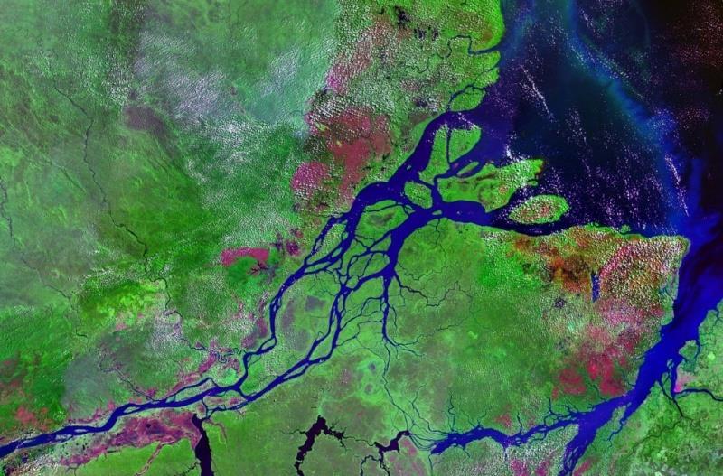
The Mississippi River Delta and The Nile River Delta: Note for the Atchafalaya River Debate
 The Mississippi River Delta and The Nile River Delta: Note for the Atchafalaya River Debate By Charles William Johnson Earth/matriX Science Today ISSN 1526-3312 P.O. Box 231126 New Orleans, Louisiana 70183-1126
GUESS WHAT OR WHO 4 WATERS Manus: Amy Bruford Producent: Claes Nordenskiöld Sändningsdatum: Längd: 9'20
 1 GUESS WHAT OR WHO 4 WATERS Manus: Amy Bruford Producent: Claes Nordenskiöld Sändningsdatum: Längd: 9'20 "Guess What or Who Theme Song Introduction" (Red Hot Chili Peppers "I Like Dirt" and Public Enemy
How to play. The center aisle divides our class into 2 teams. Team members are NOT allowed to help their teammate when they are asked a question.
 Floaters & Sinkers How to play The center aisle divides our class into 2 teams. Each person will be responsible for answering a question for every round played. Team members are NOT allowed to help their
ì<(sk$m)=beicdd< +^-Ä-U-Ä-U
=beicdd< +^-Ä-U-Ä-U") Fascinating Facts The Nile River in Egypt is the world s longest river, but the Amazon River in Brazil moves the most water. The world s largest freshwater lake is Lake Baikal in Russia. The highest temperature
Fascinating Facts The Nile River in Egypt is the world s longest river, but the Amazon River in Brazil moves the most water. The world s largest freshwater lake is Lake Baikal in Russia. The highest temperature
Month Contents Page #
 1 Dawood Public School Course Outline 2017-2018 Social Studies Class III Books: Mackay, Frances: Moorcroft, Christine. (2013). World Watch 3 and work book; Social studies for Primary schools. Oxford University
South American Countries. Capital Location Population Terrain Climate
 South American Countries Capital Location Population Terrain Climate Andes Mountains Four large areas that make up the Central Plains: Llanos, the Selva, the Gran Chaco, and the Pampas Brazilian Highlands
GEOGRAPHY OF THE WESTERN HEMISPHERE
 GEOGRAPHY OF THE WESTERN HEMISPHERE LEARNING LOG Write clear directions that describe how to get from one place to another. Choose 2 locations that other people might not know about. Did you use a map
LOCATION, LOCATION, LOCATION! Mexico, Venezuela, Cuba, and Brazil
 LOCATION, LOCATION, LOCATION! Mexico, Venezuela, Cuba, and Brazil GPS and E.Q. GPS: SS6G3 The student will explain the impact of location, climate, distribution of natural resources, and population distribution
Chapter 21: EAST AFRICA
 Chapter 21: EAST AFRICA Physical Geography of East Africa Landforms East Africa is a diverse landscape of different plains, volcanic mountains, and plateaus cut by a large valley and marked by many rivers
Study Guide Chapter 5 Ancient Egypt and Kush
 Study Guide Chapter 5 Ancient Egypt and Kush 1) cataract: a waterfall or rapids in a river Key Vocabulary Terms: 9) bureaucrat: a government official 2) delta: a fan shaped are of silt near where a river
The Lesser Antilles. Dominican Republic), and Puerto Rico
, and Puerto Rico") The Caribbean Islands are archipelagoes or groups of islands. The major archipelagoes are: The Greater Antilles - Cuba, Jamaica, Hispaniola (Composed of Haiti and the Dominican Republic), and Puerto Rico
The Caribbean Islands are archipelagoes or groups of islands. The major archipelagoes are: The Greater Antilles - Cuba, Jamaica, Hispaniola (Composed of Haiti and the Dominican Republic), and Puerto Rico
*Latin America spans 7,000 miles, from Mexico to Tierra Del Fuego. *3 Regions: Central America, South America, and the Caribbean.
 Physical Geography Latin America spans 7,000 miles, from Mexico to Tierra Del Fuego *3 Regions: Central America, South America, and the Caribbean. *Intro clip: http://www.youtube.com/watch?v=cffp6rza3
One Commodity Map. 7. What is a commodity? 8. Explain what a one-commodity country is.
 7. What is a commodity? 8. Explain what a one-commodity country is. 9. What must African countries do in order to become more stable economically? One Commodity Map Countries which OIL is the lone commodity
The Northern Tropics
 The Northern Tropics The Guianas Countries Guyana, Suriname, French Guyana Culture reflects colonial history Official Languages Guyana English Suriname Dutch French Guyana - French Religions Suriname and
Population (million) % of Africa
 % of Africa") FAO. Irrigation in in figures: AQUASTAT Survey 2005 TABLE 1 al distribution of cultivable and cultivated areas Cultivable areas Cultivated areas in 2002 In cultivable areas (ha) (ha) (%) Northern 65 320
FAO. Irrigation in in figures: AQUASTAT Survey 2005 TABLE 1 al distribution of cultivable and cultivated areas Cultivable areas Cultivated areas in 2002 In cultivable areas (ha) (ha) (%) Northern 65 320
Sub - Saharan Africa
 Sub - Saharan Africa 4/14/2015 Countries with Relative Importance GDP South Africa Gabon Botswana Land Size Sudan Chad Mozambique Madagascar Democratic Republic of the Congo (formerly Zaire) Population
Subject: Social Studies
 SY 2018/2019 1 st Final Term Revision Student s Name: Grade: 6A/B Subject: Social Studies Teacher Signature Worksheets in Social Studies 6 Unit 2 Lesson 3 World Seas pages 37-40 WB. Pp. 22-25 Lesson 4
South America. Land of Color and Contrast
 South America Land of Color and Contrast Home to: *The world s largest river system *The longest mountain chain, and second tallest mountains *Earth s driest desert *One of the world s great grassland
MCGRAW-HILL EUROPE. Chapter 11 Physical Geography Pages 332 to 341
 MCGRAW-HILL EUROPE Chapter 11 Physical Geography Pages 332 to 341 Countries of Western Europe Benelux Countries UK, France, Luxembourg, Germany, Netherlands, Belgium, Austria, Switzerland, Belgium, Monaco,
Chapter 4. Ancient Egypt and Kush Section 1: Geography & Ancient Egypt
 Chapter 4 Ancient Egypt and Kush Section 1: Geography & Ancient Egypt The gift of the nile Geography played a key role in the development of the Egyptian civilization. The Nile River brought life to Egypt.
BRITANNICA STUDENT ENCYCLOPEDIA. Africa is the world s second largest continent. More than 50 countries make up
 JOBNAME: No Job Name PAGE: 33 SESS: 682 OUTPUT: Thu Aug 31 10:43:41 2006 38 Africa BRITANNICA STUDENT ENCYCLOPEDIA Africa Africa is the world s second largest continent. More than 50 countries make up
Brazil Today The Amazon River and Basin
 Non-fiction: Brazil Today The Amazon River and Basin Brazil Today The Amazon River and Basin Deep within the Andes Mountains of northern Peru, two rivers flow together. Their junction forms one of the
2009 Carole Marsh/Gallopade International
 Live Work Play Learn LIVE LEARN WORK TM PLAY 2009 Carole Marsh/Gallopade International Permission is hereby granted to the individual purchaser or classroom teacher to reproduce materials in this book
THE PHYSICAL AND CULTURAL GEOGRAPHY OF SOUTH AMERICA
 THE PHYSICAL AND CULTURAL GEOGRAPHY OF SOUTH AMERICA 1 Global location Relative to European capitals Relative to US cities Time zones Two oceans Pacific rim countries - farther to Asia than USA Not on
Rivers of the World. The Nile. The Rhine
 The Nile The Nile is traditionally considered to be the longest river in the world. It is 4132 miles (6650 km) long that s nearly seven times the distance from John o Groats at the top of Scotland to Land
Latin America and The Caribbean. A Closer Look.
 Latin America and The Caribbean A Closer Look. Mexico Capital: Mexico City The Location of Mexico Mexico is the second-largest country by size and population in Latin America.but the Largest Spanish -
1 What do you know about Brazil? What. 2 What would you like to know about Brazil? 3 Look at the short movie clips below to see
 This fact sheet introduces you to the beautiful country of Brazil with its varied scenery. 1 What do you know about Brazil? What is Brazil famous for? Make a list of the facts that you know about the country