OUR COUNTRY INDIA L OCATIONAL SETTING
|
|
|
- Rodney Bennett
- 5 years ago
- Views:
Transcription

1 7 India is a country of vast geographical expanse. In the north, it is bound by the lofty Himalayas. The Arabian Sea in the west, the Bay of Bengal in the east and the Indian Ocean in the south, wash the shores of the Indian peninsula. India has an area of about 3.28 million sq. km. The north-south extent from Kashmir to Kanyakumari is about 3,200 km. And the east-west extent from Arunachal Pradesh to Kuchchh is about 2,900 km. The lofty mountains, the Great Indian Desert, the Northern Plains, the uneven plateau surface and the coasts and islands present a diversity of landforms. There is a great variety in the climate, vegetation, wildlife as well as in the language and culture. In this diversity, we find unity that is reflected in traditions that bind us as one nation. India has a population of more than one hundred twenty crores since the year It is the second most populous country of the world after China. L OCATIONAL SETTING India is located in the northern hemisphere. The Tropic of Cancer (23 30 ' N) passes almost halfway through the country (Figure 7.2). From south to north, main land of India extends between 8 4 ' N and 37 6 ' N latitudes. From west to east, India extends between 68 7 ' E and ' E longitudes. If we divide the world into eastern and western hemispheres, which hemisphere would India belong to? Due to great longitudinal extent of about 29, there could be a wide differences in local time of places located at two extreme points of India. As such, the difference between these two points would be of The peninsula is a piece of land that is surrounded by water on three sides (figure 6.1). Do you know? Large countries which stretch extensively from east to west do not have a single Standard Time for the whole country. The USA and Canada have seven and six time zones respectively. Do you remember how many time zones are there in Russia?
 than in the west (Gujarat).")
2 about two hours. As you have learnt earlier, the local time changes by four minutes for every one degree of longitude. The sun rises about two hours earlier in the east (Arunachal Pradesh) than in the west (Gujarat). You have already read earlier, why the local time of longitude of 82 30'E has been taken as the Indian Standard Time. This meridian or longitude is also termed as the Standard Meridian of India. INDIA S NEIGHBOURS There are seven countries that share land boundaries with India. Find out names Figure 7.1 : India and its neighbouring countries 48 THE EAR TH : OUR HABITAT

3 PA K IS TA N CHINA (TIBET) N E P A L BHUTAN BANGLADESH MYANMAR Figure 7.2 : Political map of India 49

4 of these countries from the Figure 7.1. How many of these countries do not have access to any ocean or sea? Across the sea to the south, lie our island neighbours Sri Lanka and Maldives. Sri Lanka is separated from India by the Palk Strait. P OLITICAL AND ADMINISTRATIVE DIVISIONS India is a vast country. For administrative purposes, the country is divided into 28 Figure 7.3 : India : Physical Divisions 50 THE EAR TH : OUR HABITAT
5 States and 7 Union Territories (Appendix-I). Delhi is the national capital. The states have been formed mainly on the basis of languages. Rajasthan is the largest state and Goa is the smallest state in terms of area. The states are further divided into districts. PHYSICAL D IVISIONS India is marked by a diversity of physical features such as mountains, plateaus, plains, coasts and islands. Standing as sentinels in the north are the lofty snowcapped Himalayas. Him+alaya mean the abode of snow. The Himalayan mountains are divided into three main parallel ranges. The northernmost is the Great Himalaya or Himadri. The world s highest peaks are located in this range. Middle Himalaya or Himachal lies to the south of Himadri. Many popular hill stations are situated here. Find out the names of five hill stations. The Shiwalik is the southernmost range. The Northern Indian plains lie to the south of the Himalayas. They are generally level and flat. These are formed by the alluvial deposits laid down by the rivers the Indus, the Ganga, the Brahmaputra and their tributaries. These river plains provide fertile land for cultivation. That is the reason for high concentration of population in these plains. In the western part of India lies the Great Indian desert. It is a dry, hot and sandy stretch of land. It has very little vegetation. To the south of northern plains lies the Peninsular plateau. It is triangular in shape. The relief is highly uneven. This is a region with numerous hill ranges and valleys. Aravali hills, one of the oldest ranges of the world, border it on the north-west side. The Vindhyas and the Satpuras are the important ranges. The rivers Narmada and Tapi flow through these ranges. These are west-flowing rivers that drain into the Arabian Sea. The Western Ghats or Sahyadris border the plateau in the west and the Eastern Ghats provide the eastern boundary. While the Western Ghats are almost continuous, the Eastern Ghats are broken and uneven (Figure 7.3). The plateau is rich in minerals like coal and iron-ore. To the West of the Western Ghats and the East of Eastern Ghats lie the Coastal plains. The western Alluvial deposits : These are very fine soils, brought by rivers and deposited in the river basins. Tributary : A river or stream which contributes its water to a main river by discharging it into main river from either side (Figure 6.1). Do you know? The Ganga and the Brahmaputra form the world s largest delta, the Sundarbans delta. The delta is triangular in shape. It is an area of land formed at the mouth of the river (Where rivers enter the sea, that point is called the mouth of the river, Figure 6.1). Let s Do Many girls are named after rivers eg. Yamuna, Mandakini, and Kaveri. Do you know anyone in your locality who is named after a river? Ask your parents and others and make a list of such names. Could you also find other names related to water e.g. Shabnam? 51


6 Do you know? Corals are skeletons of tiny marine animals called Polyps. When the living polyps die, their skeletons are left. Other poplyps grow on top of the hard skeleton which grows higher and higher, thus forming the coral islands. Figure 7.4 shows Coral islands. Figure 7.4 : Coral Islands coastal plains are very narrow. The eastern Coastal plains are much broader. There are a number of east flowing rivers. The rivers Mahanadi, Godavari, Krishna and Kaveri drain into the Bay of Bengal. These rivers have formed fertile deltas at their mouth. The Sunderban delta is formed where the Ganga and Brahmaputra flow into the Bay of Bengal. Danger Waters 52 THE EAR TH : OUR HABITAT
7 53
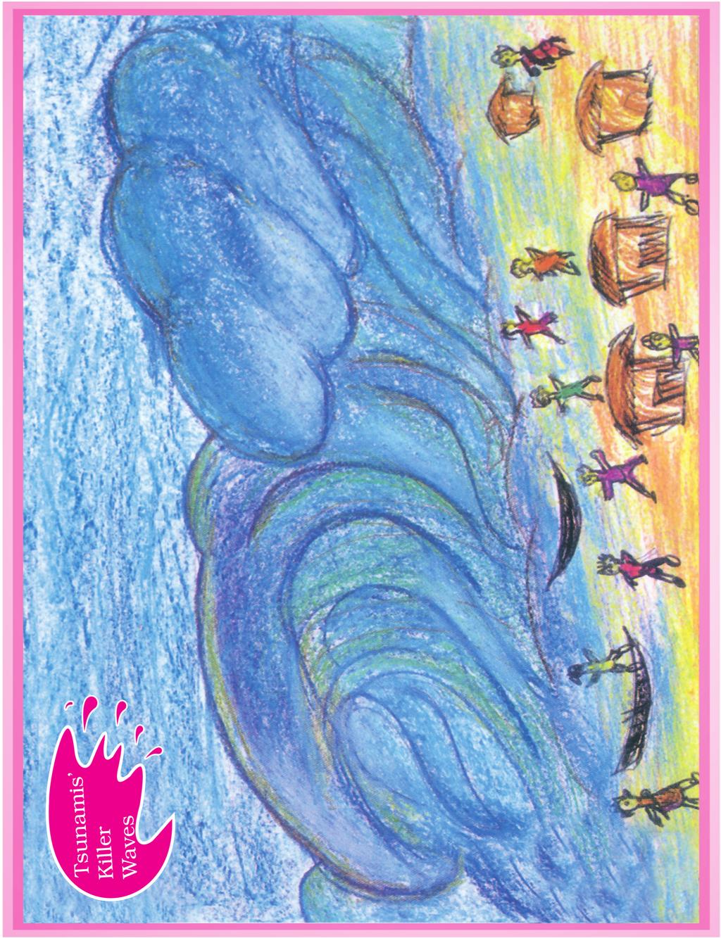
8 Two groups of islands also form part of India. Lakshadweep Islands are located in the Arabian Sea. These are coral islands located off the coast of Kerala. The Andaman and the Nicobar Islands lie to the southeast of the Indian mainland in the Bay of Bengal. Do you know which group of islands were affected by the Tsunami in 2004? Find out through newspaper reports and by speaking to people how in different ways people faced this challenge when Tsunami struck the Indian coast. Tsunami is a huge sea wave generated due to an earthquake on the sea floor. 1. Answer the following questions briefly. (a) (b) (c) (d) (e) (f) (g) Name the major physical divisions of India. India shares its land boundaries with seven countries. Name them. Which two major rivers fall into the Arabian Sea? Name the delta formed by the Ganga and the Brahmaputra. How many States and Union Territories are there in India? Which states have a common capital? Why do a large number of people live in the Northern plains? Why is Lakshadweep known as a coral island? 2. Tick the correct answers. (a) (b) (c) (d) The southernmost Himalayas are known as (i) Shiwaliks (ii) Himadri (iii) Himachal Sahyadris is also known as (i) Aravali (ii) Western Ghats (iii) Himadri The Palk Strait lies between the countries (i) Sri Lanka and Maldives (ii) India and Sri Lanka (iii) India and Maldives The Indian islands in the Arabian Sea are known as (i) Andaman and Nicobar Islands (ii) Lakshadweep Islands (iii) Maldives 54 THE EARTH : OUR HABITA T
9 (e) The oldest mountain range in India is the (i) Aravali hills (ii) Western ghats (iii) Himalayas 3. Fill in the blanks. (a) (b) (c) (d) (e) India has an area of about. The Greater Himalayas are also known as. The largest state in India in terms of area is. The river Narmada falls into the sea. The latitude that runs almost halfway through India is. Map skills 1. On an outline map of India, mark the following. (a) (b) (c) (d) (e) Tropic of Cancer Standard Meridian of India State in which you live Andaman Islands and Lakshadweep Islands Western Ghats and Eastern Ghats 55
PHYSIOGRAPHIC DIVISION OF INDIA
 PHYSIOGRAPHIC DIVISION OF INDIA INTRODUCTION India is vast country there have great diversity in it s physical features. Physical Division Of India are divided into following five Division. 1. The Northern
DR.M.K.K.ARYA MODEL SCHOOL SOCIAL SCIENCE CLASS IV ASSIGNMENT CH-8 THE SOUTHERN PLATEAU
 DR.M.K.K.ARYA MODEL SCHOOL SOCIAL SCIENCE CLASS IV ASSIGNMENT CH-8 THE SOUTHERN PLATEAU Q1. Define the Central Highlands. A.1)The Central Highland is wide in the west but narrow in the east. 2). These
South, Southeast, and East Asia Physical Geography
 South, Southeast, and East Asia Physical Geography Mountains A. B. C. Mountains are important in Asia because they influence: Population patterns Movement of people and goods Climate Himalaya Mountains
EXPLORING EARTH S SURFACE. Lesson 4
 EXPLORING EARTH S SURFACE Lesson 4 Introduction Lewis and Clark In 1804, an expedition set out from near Saint Louis to explore the land between the Mississippi River and the Pacific Ocean, The United
MT - GEOGRAPHY - (73) - SEMI PRELIM - II : PAPER - 3
 - SEMI PRELIM - II : PAPER - 3") MT 2018 1100 Seat No. MT - GEOGRAPHY - (73) - SEMI PRELIM - II : PAPER - 3 Time : 2 Hours (Pages 5) Max. Marks : 0 Q.1. Fill in the blank choosing the correct alternative : (a) On the foot hills of the
MT 2018 1100 Seat No. MT - GEOGRAPHY - (73) - SEMI PRELIM - II : PAPER - 3 Time : 2 Hours (Pages 5) Max. Marks : 0 Q.1. Fill in the blank choosing the correct alternative : (a) On the foot hills of the
BOARD ANSWER PAPER: OCTOBER 2014
 BOARD ASWER PAPER: OCTOBER 2014 GEOGRAPHY AD ECOOMICS Q.1. (A) Complete the following statements by choosing the appropriate alternatives from those given in the brackets and rewrite the sentence in your
MT - GEOGRAPHY - (73) - SEMI PRELIM - I : PAPER - 6
 - SEMI PRELIM - I : PAPER - 6") 08 00 MT MT - GEOGRAPHY - (73) - SEMI PRELIM - I : PAPER - 6 Time : Hours (Model Answer Paper) Max. Marks : 0 Q.. Fill in the blank choosing the correct alternative : (a) In India, there has been a slight
08 00 MT MT - GEOGRAPHY - (73) - SEMI PRELIM - I : PAPER - 6 Time : Hours (Model Answer Paper) Max. Marks : 0 Q.. Fill in the blank choosing the correct alternative : (a) In India, there has been a slight
17. Ganga-Jamuna doab is the largest doab region of India. 18. The eastern and western coastal plains meet at Kanyakumari. 19. Kerala Coast is also
 GEOGRAPHY OF INDIA 1. India is the world s seventh largest Country. 2. It occupies 2.42% of the total world area. 3. The total land frontier of India is 15,200 K.M. 4. The total coastline of India is 7,516
National Biodiversity Strategy and Action Plan, India
 Final Technical Report of the UNDP-GEF Sponsored Project National Biodiversity Strategy and Action Plan, India Volume 2 Executing Agency Ministry of Environment and Forests, Government of India Technical
The Geological Pacific Northwest. Wednesday February 6, 2012 Pacific Northwest History Mr. Rice
 The Geological Pacific Northwest Wednesday February 6, 2012 Pacific Northwest History Mr. Rice 1 Free Response #2 Please do not simply list the items for this response. Full sentences!!! Minimum of 3-5
DESPITE GLOBAL ISSUES, TOURISM IS ON A GROWTH PATH
 India is, the cradle of the human race, the birthplace of human speech, the mother of history, the grandmother of legend, and the great grand mother of tradition. Our most valuable and most instructive
Label your Map with Russia. Map Activity
 Bell Activity How many time zones does the U.S. have? How do these time zones affect life in the U.S.? Russia is so large it has 11 time zones. What difficulties might this create? Objectives Know landforms,
Latin America s Physical Geography. EQ: What are characteristics of Latin America s physical features?
 Latin America s Physical Geography EQ: What are characteristics of Latin America s physical features? Your Task: We are going to participate in a Museum Walk! You will travel around the room with a partner
CHAPTER 12. South America. Section 1: Natural Environments Section 2: History and Culture Section 3: South America Today. HOLT World Geography
 CHAPTER 12 South America Section 1: Natural Environments Section 2: History and Culture Section 3: South America 1 Section 1 Natural Environments Objectives: What are the major landforms and rivers of
Monday, December 11, 2017
 Monday, December 11, 2017 Physical Geography of Russia Objective: complete Warm-Up, write outline notes and discuss the geography of Eastern Europe/mother Russia and view Geography Now: Belarus. География
SS8G1 The student will describe Georgia with regard to physical features and location.
 SS8G1ab Standards SS8G1 The student will describe Georgia with regard to physical features and location. a. Locate Georgia in relation to the region, nation, continent, and hemispheres. b. Describe the
Oceania. Australia, New Zealand, and the Pacific Islands. Physical Geography. Where is Australia located?
 Oceania Australia, New Zealand, and the Pacific Islands Physical Geography Australia New Zealand Oceania Where is Australia located? Australia & Oceania are a group of islands located between Asia, Antarctica,
DR.M.K.K ARYA MODEL SCHOOL Class-IV Sub: Social science Assignment-Chapter 1
 DR.M.K.K ARYA MODEL SCHOOL Assignment-Chapter 1 Q1.What is the length and breadth of India? A. The length of India is 3,214 kms from Jammu and Kashmir in north to Kanyakumari in the south. Its breadth
DR.M.K.K ARYA MODEL SCHOOL Class-IV Sub: Social science Assignment-Chapter 1
 DR.M.K.K ARYA MODEL SCHOOL Class-IV Sub: Social science Assignment-Chapter 1 Q1 What is the length and breadth of India? A. 1) The length of India is 3,214 kms from Jammu and Kashmir in north to Kanyakumari
Do Not Write On This Sheet. World Rally. City, country, continient: to city, country, continent:
 World Rally At each checkpoint you must list the city, country, and continent. The teacher must check all answers before you can go on to the next checkpoint. Checkpoint 1: Start at: 29 N 98 W and go to:
2015 Brain Wrinkles. SS8G1b
 SS8G1b Georgia is a geographically diverse state that is divided into five regions. The first three regions (Appalachian Plateau, Valley and Ridge, and Blue Ridge) are in the mountains and foothills of
Chapter 17. North Africa, Southwest Asia and Central Asia
 Chapter 17 North Africa, Southwest Asia and Central Asia Chapter Objectives Describe the major landforms and natural resources of North Africa, Southwest Asia, and Central Asia. Discuss the climate and
Coral Reef status in South Asian Seas Region and its possible restoration partnering with other Agencies
 Coral Reef status in South Asian Seas Region and its possible restoration partnering with other Agencies Dr. Sivaji Patra Senior Programme Officer (Regional) South Asian Seas Programme-SACEP 06 th December,
BY Saurabh Pandey Junior research fellow(jrf) NET, MA, B.TECH 3 Years teaching experience UPSC Faculty
 NET, MA, B.TECH 3 Years teaching experience UPSC Faculty") Important topics(mapping) PART-2 BY Saurabh Pandey Junior research fellow(jrf) NET, MA, B.TECH 3 Years teaching experience UPSC Faculty 1. Indus R. 2 Satluj R 3. Chenab R 4. Beas R 5. Rohtang pass. 6.
Important topics(mapping) PART-2 BY Saurabh Pandey Junior research fellow(jrf) NET, MA, B.TECH 3 Years teaching experience UPSC Faculty 1. Indus R. 2 Satluj R 3. Chenab R 4. Beas R 5. Rohtang pass. 6.
The Himalayan Future Transition, Equity and Ecological Stability. Jayanta Bandyopadhyay
 The Himalayan Future Transition, Equity and Ecological Stability Jayanta Bandyopadhyay Himalaya the Mountain of Diversity The Himalaya has been mentioned in many writings, both ancient and modern, scientific
Location, Climate, & Natural Resources
 Location, Climate, & Natural Resources UK is a country of islands off the coast of mainland Europe. It consists of England, Northern Ireland, Scotland, & Wales. UK s location makes it a HUB for trade.
India - State-wise Wastelands Distribution (Percentage to total geographical area)
") WASTELAND MAP 25-6 INDIA Figure. 1 Gullied/ Ravine land-medium ravine Gullied/Ravine land-deep/ very deep ravine Scrubland - Land with dense scrub Scrubland - Land with open scrub Waterlogged and marshy
WASTELAND MAP 25-6 INDIA Figure. 1 Gullied/ Ravine land-medium ravine Gullied/Ravine land-deep/ very deep ravine Scrubland - Land with dense scrub Scrubland - Land with open scrub Waterlogged and marshy
Latin America. Chapter 9 Physical Geography
 Latin America Chapter 9 Physical Geography Latin American Regions Middle America includes Mexico and the Central American countries The Caribbean Islands South America Mexico Landforms Sierra Madre Oriental
Development of Ski Resorts in the Indian Himalayas
 Development of Ski Resorts in the Indian Himalayas AMITABH SHARMA SKI HIMALAYAS # 1 Pocket 52, C.R Park New Delhi 110019 +91-9816055555 Email : amitabhsharma_manali@rediffmail.com The Himalayas are a vast
Location, Climate, & Natural Resources Brain Wrinkles
 Location, Climate, & Natural Resources Standards SS6G10 The student will explain the impact of location, climate, natural resources, and population distribution on Europe. a. Compare how the location,
Rivers. Highlights of some of the World s Most Famous Rivers!
 Rivers Highlights of some of the World s Most Famous Rivers! Directions This Power Point presentation contains information about some of the most famous rivers in the world! Students should use this presentation
Latin America. Physical Geography
 Latin America Physical Geography Regions Latin America can be divided into separate regions based on physical geography or cultural geography. Regions If we look at physical geography Latin America has
Chapter 20. The Physical Geography of Africa South of the Sahara
 Chapter 20 The Physical Geography of Africa South of the Sahara Chapter Objectives Identify the major landforms, water systems, and natural resources of Africa south of the Sahara. Describe the relationship
Friday, November 10, 2017
 Friday, November 10, 2017 Andes and Midlatitude Countries Objective: Summarize the main physical features and regions of the Southern Cone. Identify and locate the urban centers and understand the pattern
Key Geographic Features
 DUE 12/6/18 Name: Lesson One: Egypt Geography 6.15 On a historical map locate the Mediterranean and Red Seas, the Nile River and Delta, and the areas of ancient Nubia and Egypt. Identify the locations
Geography Challenge Questions for Key Parts of the World Map
 S T U E N T H N O U T Geography hallenge Questions for Key Parts of the World Map 1. Label the largest continent. 6. Label the ocean that touches the shores of both Europe and South merica. 2. Label the
STUDY GUIDE. The Land. Chapter 29, Section 1. Both. Terms to Know DRAWING FROM EXPERIENCE ORGANIZING YOUR THOUGHTS
 Chapter 29, Section 1 For use with textbook pages 719 724. The Land Terms to Know cordilleras Parallel mountain ranges and plateaus (page 719) archipelago A group of islands (page 720) insular Relating
STUDY GUIDE. The Land. Physical Features of Latin America. Chapter 8, Section 1. Terms to Know DRAWING FROM EXPERIENCE ORGANIZING YOUR THOUGHTS
 For use with textbook pages 193 198. The Land Terms to Know cordillera A mountain range that runs parallel to another mountain range (page 194) altiplano A high plain (page 194) escarpment A steep cliff
CH. 1 Europe and Russia: Physical Geography. Section 1 Land and Water p Europe and Russia are part of the world s largest landmass called.
 CH. 1 Europe and Russia: Physical Geography Section 1 Land and Water p.10-16 Europe and Russia are part of the world s largest landmass called. The country of Russia stretches over both continents. About
The Maltese Islands: Geography
 The Maltese Islands: Geography The Maltese Archipelago comprises a group of small low islands aligned in a NW-SE direction. At their extreme points the Maltese Islands fall within the following points:
Chapter 14. The Physical Geography of Russia
 Chapter 14 The Physical Geography of Russia Chapter Objectives Identify the physical features and natural resources of Russia. Discuss the effects of Russia s climate and vegetation on life in the region.
SOL VS.2a, 2b, 2c, 10b
 What are the characteristics of the Coastal Plain? 1. Also known as Tidewater 2. Located near the Atlantic Ocean and the Chesapeake Bay 3. Includes the Eastern Shore, a peninsula between the Atlantic Ocean
Introduction to Africa
 Introduction to Africa Did you know? Africa has more countries than any other continent. The Sahara is a desert that is the size of the U.S. It s the world's largest desert. Most of the world s gold and
Chapter Objectives. Describe the dominant landforms and natural resources of Southeast Asia. Discuss Southeast Asia s climate and vegetation.
 Chapter Objectives Describe the dominant landforms and natural resources of Southeast Asia. Discuss Southeast Asia s climate and vegetation. The Land Section 1 Objectives Describe how tectonic plates and
Just how big is Africa?
 The United States China India The United Kingdom Portugal Spain France Belgium Germany The Netherlands Switzerland Italy Eastern Europe Japan 11.7 million sq. miles Just how big is Africa? Chapter 18 Section
Portuguese Language - Fostering National Unity
 Geography Brazil Brazil Portuguese Language - Fostering National Unity 11 dialects of Portuguese Influenced by Amerindian and African languages, creating differences between Portuguese spoken in Brazil
area sq. km capital - Camberra situated on the southern hemisphere, surrounded by the Indian and Pacific ocean
 Otázka: Australia and New Zealand Jazyk: Angličtina Přidal(a): Petra The commonwealth of Australia area 7 700 000 sq. km capital - Camberra situated on the southern hemisphere, surrounded by the Indian
Chapter 10 Test on Australia
 Name Score Chapter 10 Test on Australia Part 1 - True/False Read each statement carefully. If it is true, clearly mark T in the blank space. If it is false, clearly mark F in the blank space. For false
IMPACTS OF THE RECENT TSUNAMI ON THE BUNDALA NATIONAL PARK THE FIRST RAMSAR WETLAND IN SRI LANKA
 IMPACTS OF THE RECENT TSUNAMI ON THE BUNDALA NATIONAL PARK THE FIRST RAMSAR WETLAND IN SRI LANKA by C.N.B. Bambaradeniya, IUCN The World Conservation Union, Sri Lanka Country Office (Email: cnb@iucnsl.org)
Grade 5 Geography Term 1
 1 Grade 5 Geography Term 1 Contents Section 1: World map and compass directions... 2 The position of the equator and the North and South Poles on a globe... 2 The seven continents of the world... 3 The
6th Grade Third Nine Weeks Benchmark Assessment
 6th Grade Third Nine Weeks Benchmark Assessment Multiple Choice Identify the choice that best completes the statement or answers the question. Key Concepts 1 Latin America is located in the A Northern
Model Answer Paper Max. Marks : 40
 07...... 00 MT MT SOCIAL SCIENCE (73) GEOGRAPHY & ECONOMICS SEMI PRELIM I PAPER V (E) Time : Hours Model Answer Paper Max. Marks : 0 A.. (A) Complete and write the following statements by choosing appropriate
Mrs. Davis s Adventures
 Mrs. Davis s Adventures Latin America Countries & Political Map NAME: DATE: PERIOD: DIRECTIONS: Use your mapping skills and textbook pages: 127, 97, and 3 to complete Mrs. Davis s Story. Transfer the countries
2018 Spring Semester Final : STUDY GUIDE
 Name: Hr: 2018 Spring Semester Final : STUDY GUIDE My final is on:, May My final will have questions and will be COLONIZATION OF NORTH & SOUTH AMERICA - Match the regions with the European countries that
Terms to Know. artesian well coral atoll krill lagoon
 Chapter Objectives Describe the diverse landforms and natural resources of Australia, Oceania, and Antarctica. Discuss the wide range of climates and vegetation throughout the region. The Land Section
Objective. Students will familiarize themselves with the physical features and climates of Latin America.
 Journal Write KWL What do you KNOW about Latin America? What do you WANT TO KNOW about Latin America? What did you LEARN today that you didn t know before? Latin America Objective Students will familiarize
Unit 1: Physical Geography Notes
 - How has the physical world impacted settlement patterns? o Major factors in the decision-making process of o Before the boom controlling the physical environment was not possible on a large scale - Physical
DAINIK EXPRESS. Largest, Highest and Biggest in India. Team of DAINIK EXPRESS
 DAINIK EXPRESS 2015 Largest, Highest and Biggest in India Team of DAINIK EXPRESS WWW.DAINIKEXPRESS.COM 2014-2015 1 Largest Populated City in India - Mumbai Facts about Mumbai State: Maharashtra Population:
Chapter 16 ~ Eastern Mediterranean
 Chapter 16 ~ Eastern Mediterranean Physical Geography of the Eastern Mediterranean Landforms This area is known as the Levant and includes Syria, Jordan, Lebanon, Israel, and the Palestinian territories.
SOUTHWEST MONSOON-2010: DAILY FLOOD SITUATION REPORT SUMMARY OF IMPORTANT EVENTS AS ON
 SITREP NO-40/2010 1700 hours No.32-20/2010-NDM-I Ministry of Home Affairs (Disaster Management Division) Dated, 10 th July, 2010 Subject: SOUTHWEST MONSOON-2010: DAILY FLOOD SITUATION REPORT SUMMARY OF
Hungry 4 History Trivia VA Studies 2010 and beyond
 Hungry 4 History Trivia VA Studies 2010 and beyond Level 1 1 What may be described using terms that show connections between two places such as: next to, near, or bordering? 2 3 What two large bodies of
CANADA: ITS LAND, RESOURCES, & ECONOMY PRE-TEST
 PRE-TEST Name Directions: In the blank space, write a "T" if the statement is true and an "F" if the statement is false. 1. Canada has 11 geographic regions. 2. The cordillera is found in central Canada.
The Land Photo Source: The Atlas of Canada, The Red River, Manatoba, Canada land/physio_red_ri
 The Land The United States and Canada An Overview of the Region The United States and Canada are the two largest countries in North America. The Rio Grande is part of the southwest border of the United
Latin America and The Caribbean. A Closer Look.
 Latin America and The Caribbean A Closer Look. Mexico Capital: Mexico City The Location of Mexico Mexico is the second-largest country by size and population in Latin America.but the Largest Spanish -
MCGRAW-HILL EUROPE. Chapter 11 Physical Geography Pages 332 to 341
 MCGRAW-HILL EUROPE Chapter 11 Physical Geography Pages 332 to 341 Countries of Western Europe Benelux Countries UK, France, Luxembourg, Germany, Netherlands, Belgium, Austria, Switzerland, Belgium, Monaco,
2015 Brain Wrinkles. SS8G1b
 SS8G1b Standards SS8G1 The student will describe Georgia with regard to physical features and location. b. Describe the five geographic regions of Georgia; include the Blue Ridge Mountains, Valley and
PHYSIOGRAPHY OF INDIA
 PHYSIOGRAPHY OF INDIA India is the seventh largest and second most populous country in the world. Its area is 2.4% of the total world area but about 16% of the entire human races reside in its fold. In
Most Wanted MCQs About Oceans and Seas for Competitive Exams
 1. What is average depth of oceans? (a) 5,730 metres (Correct) (b) 3,760 metres (c) 4,690 metres (d) 2,930 metres 2. Which of following is the largest ocean that covers about one-third of the surface of
Unit 1. School Days. First Nine Weeks
 Study Buddy Unit 1 School Days First Nine Weeks Teacher- A person who helps us learn. Map- A drawing that shows where places are. Group- A number of people doing an activity together. Rule- What you must
Wednesday, April 4, 2018
 Wednesday, April 4, 2018 Physical Geography of Japan Objective: Outline the countries and territories that are included in East Asia. Describe the main physical features and climate types of each country.
Curriculum Pacing Guide Grade/Course 5 Th Grade Geography Grading Period 1 st Nine Weeks
 2013-2014 Curriculum Pacing Guide Grade/Course 5 Th Grade Grading Period 1 st Nine Weeks Time Frame Unit/ photographs, pictures, and tables to Locate and identify: Continents and Oceans -North America
There are actually six geographic sub-regions, three in both the uplands and the lowlands.
 6 Regions of AR Although Arkansas is most easily divided into two distinct geographical regions, the northwestern uplands and the southeastern lowlands, this description does not accurately portray the
The Lesser Antilles. Dominican Republic), and Puerto Rico
, and Puerto Rico") The Caribbean Islands are archipelagoes or groups of islands. The major archipelagoes are: The Greater Antilles - Cuba, Jamaica, Hispaniola (Composed of Haiti and the Dominican Republic), and Puerto Rico
The Caribbean Islands are archipelagoes or groups of islands. The major archipelagoes are: The Greater Antilles - Cuba, Jamaica, Hispaniola (Composed of Haiti and the Dominican Republic), and Puerto Rico
CONTENTS. Chapter 1: Geographic Overview 21. Chapter 2: Human Interactions with India s Environment 44
 CONTENTS Introduction 14 Chapter 1: Geographic Overview 21 Relief 23 The Himalayas 23 The Indo-Gangetic Plain 26 The Deccan 27 Drainage 30 Drainage into the Bay of Bengal 30 Drainage into the Arabian Sea
Chapter 16 ~ Eastern Mediterranean
 Chapter 16 ~ Eastern Mediterranean Physical Geography of the Eastern Mediterranean Landforms This area is known as the Levant and includes Syria, Jordan, Lebanon, Israel, and the Palestinian territories.
SOUTHWEST MONSOON-2008: DAILY FLOOD SITUATION REPORT
 32-20/2008-NDM-I Ministry of Home Affairs (Disaster Management Division) SITREP NO-133/2008 1700 hours Dated, 11 th October, 2008 Subject: SOUTHWEST MONSOON-2008: DAILY FLOOD SITUATION REPORT SUMMARY OF
February 18. National Parks in India
 2016 February 18 National Parks in India National Parks in India Published in 2016 February 18 Prepared by www.keralapschelper.com Price Free All Right Reserved No Part of this publication can be reproduced
3rd GRADE MINIMUM CONTENTS UDI 1: LANDSCAPES (5)
") 3rd GRADE MINIMUM CONTENTS UDI 1: LANDSCAPES (5) DIFFERENT LANDSCAPES A landscape is all the things that we see in a place. There are different types of landscapes. Mountain landscapes have mountains and
3rd GRADE MINIMUM CONTENTS UDI 1: LANDSCAPES (5) DIFFERENT LANDSCAPES A landscape is all the things that we see in a place. There are different types of landscapes. Mountain landscapes have mountains and
ALBERTA S GRASSLANDS IN CONTEXT
 ALBERTA S GRASSLANDS IN CONTEXT GLOBAL GRASSLANDS 1 Temperate grasslands, located north of the Tropic of Cancer and south of the Tropic of Capricorn, are one of the world s great terrestrial biomes 2.
Academic Vocabulary Social Studies, 5-8 (adapted from Building Academic Vocabulary by Robert Marzano.)
") Academic Vocabulary Social Studies, 5-8 (adapted from Building Academic Vocabulary by Robert Marzano.) Provide a student-friendly description, explanation, or example of the term. 7 Continents of the World
Academic Vocabulary Social Studies, 5-8 (adapted from Building Academic Vocabulary by Robert Marzano.) Provide a student-friendly description, explanation, or example of the term. 7 Continents of the World
Himalayas Nepal: Complete Guide On Travel & Tourism Of Nepal, Bhutan, Tibet, Sikkim And Darjeeling READ ONLINE
 Himalayas Nepal: Complete Guide On Travel & Tourism Of Nepal, Bhutan, Tibet, Sikkim And Darjeeling READ ONLINE If you are searching for the book Himalayas Nepal: Complete Guide on Travel & Tourism of Nepal,
2019. January 18 & 19
 2019. January 18 & 19 The Leela Ambience Convention Hotel, Delhi India's leading trade show on Business, MICE and Luxury Travel www.bltm.co.in 150+ Sellers 250+ Hosted Buyers 11 Countries 5,000+ Scheduled
An Overview of Airport Infrastructure in India. By V.P.Agrawal, Chairman, Airports Authority of India
 An Overview of Airport Infrastructure in India By V.P.Agrawal, Chairman, Airports Authority of India Global Economic Scenario Global economies now seeing recovery. Asia Pacific economies GDP levels to
Exploring Mexico. Directions: Complete the paragraphs below. Write the correct word from the Word Bank to complete each sentence.
 Exploring Mexico Section 1 10 Directions: Complete the paragraphs below. Write the correct word from the Word Bank to complete each sentence. Word Bank United States Central Plateau irrigation isthmus
LOCATION, CLIMATE, AND NATURAL RESOURCES OF MEXICO
 SS6G3 The student will explain the impact of location, climate, distribution of natural resources, and population distribution on Latin America and the Caribbean. a. Compare how the location, climate,
PHYSICAL GEOGRAPHY. Unit 1
 PHYSICAL GEOGRAPHY Unit 1 HOW HAS THE PHYSICAL WORLD IMPACTED SETTLEMENT PATTERNS? Major factor in the decision-making process of settlers Before the technological boom controlling the physical environment
Location, Climate, & Natural Resources. Where People Live & How They Trade
 Location, Climate, & Natural Resources Where People Live & How They Trade Standards SS6G13 The student will explain the impact of location, climate, distribution of natural resources, and population distribution
CSE Main Compulsory Paper 1.5 Geography of India
 CONTENT 1. Geographical features and their location Why is called a sub-continent? Page 2 2. The Great Himalayan Ranges Page 3 3. The Northern Plains and Soil varieties Page 6 4. Watersheds and river drainage
SS7G1 The student will locate selected features of Africa.
 Standards SS7G1 The student will locate selected features of Africa. a. Locate on a world and regional political-physical map: the Sahara, Sahel, savanna, tropical rain forest, Congo River, Niger River,
MEETINGS & INCENTIVES
 A True Original Dotted with coconut trees that are the island s namesake, Kurumba was the first private island resort in the Maldives. Lush tropical gardens, white sandy beaches, and a vibrant House Reef
Countries Of The World: Mexico
 Countries Of The World: Mexico By National Geographic Kids, adapted by Newsela staff on 06.07.18 Word Count 638 Level 800L Image 1: The pyramids of Guachimontones in Jalisco, Mexico. Mexico is a country
2.1 What is the climate like?
 José Medeiros This fact sheet allows you to see how varied the countryside is across Brazil. 2.1 What is the climate like? Most of Brazil is in the Southern Hemisphere, where the seasons are the opposite
Magnitude of Tourism
 Magnitude of Tourism 63 Index of Tables Sr.No. Table No. Page No. 1 Table 1 Total Tourist arrivals to Gujarat (2002-2011) 68 2 Table 2 Contribution of Tourism in Gujarat to State GDP 71 3 Table 3 Domestic
Geographic Qualities of South America
 Geographic Qualities of South America 1. South America is the fourth largest continent in area. It is located in the Western Hemisphere, lying southwest of North America. Most of South America lies in
Mountain Passes in Himalayas : India
 Mountain Passes in Himalayas : India Overall, the Himalayan mountain system is the world s highest, and is home to the world s highest peaks, the Eightthousanders. There are 14 Himalayan peaks with elevation
SOUTHWEST MONSOON-2008: DAILY FLOOD SITUATION REPORT
 32-20/2008-NDM-I Ministry of Home Affairs (Disaster Management Division) SITREP NO-131/2008 1700 hours Dated, 9 th October, 2008 Subject: SOUTHWEST MONSOON-2008: DAILY FLOOD SITUATION REPORT SUMMARY OF
Latin America. Physical Geography
 + Latin America Physical Geography + I. Landforms A. Caribbean & Central America 1. Mexico is dominated by two mountain chains, collectively called the Sierra Madre. A high plateau is situated in between.
Essential Questions. 1. How have historical figures and events affected South America today?
 South America Essential Questions 1. How have historical figures and events affected South America today? 2. How has location affected the development of countries in South America? 3. How has the role
Chapter 21: EAST AFRICA
 Chapter 21: EAST AFRICA Physical Geography of East Africa Landforms East Africa is a diverse landscape of different plains, volcanic mountains, and plateaus cut by a large valley and marked by many rivers
UNIT 5 AFRICA PHYSICAL GEOGRAPHY SG 1 - PART II
 UNIT 5 AFRICA PHYSICAL GEOGRAPHY SG 1 - PART II III. CLIMATE & VEGETATION A. The four main climate zones are tropical wet, tropical wet/dry (split into monsoon & savanna), semiarid, and arid. Other climate