PHOTOGRAPHS WRITTEN HISTORICAL AND DESCRIPTIVE DATA
|
|
|
- William McDaniel
- 5 years ago
- Views:
Transcription
1 Spanning Coon Creek Hulah Vicinity Osage County Oklahoma PHOTOGRAPHS WRITTEN HISTORICAL AND DESCRIPTIVE DATA HISTORIC AMERICAN ENGINEERING RECORD Submitted to: Oklahoma State Historic Preservation Office 800 Nazih Zuhdi Drive Oklahoma City, Oklahoma 73105
2 Spanning Coon Creek Hulah Vicinity Osage County Oklahoma PHOTOGRAPHS
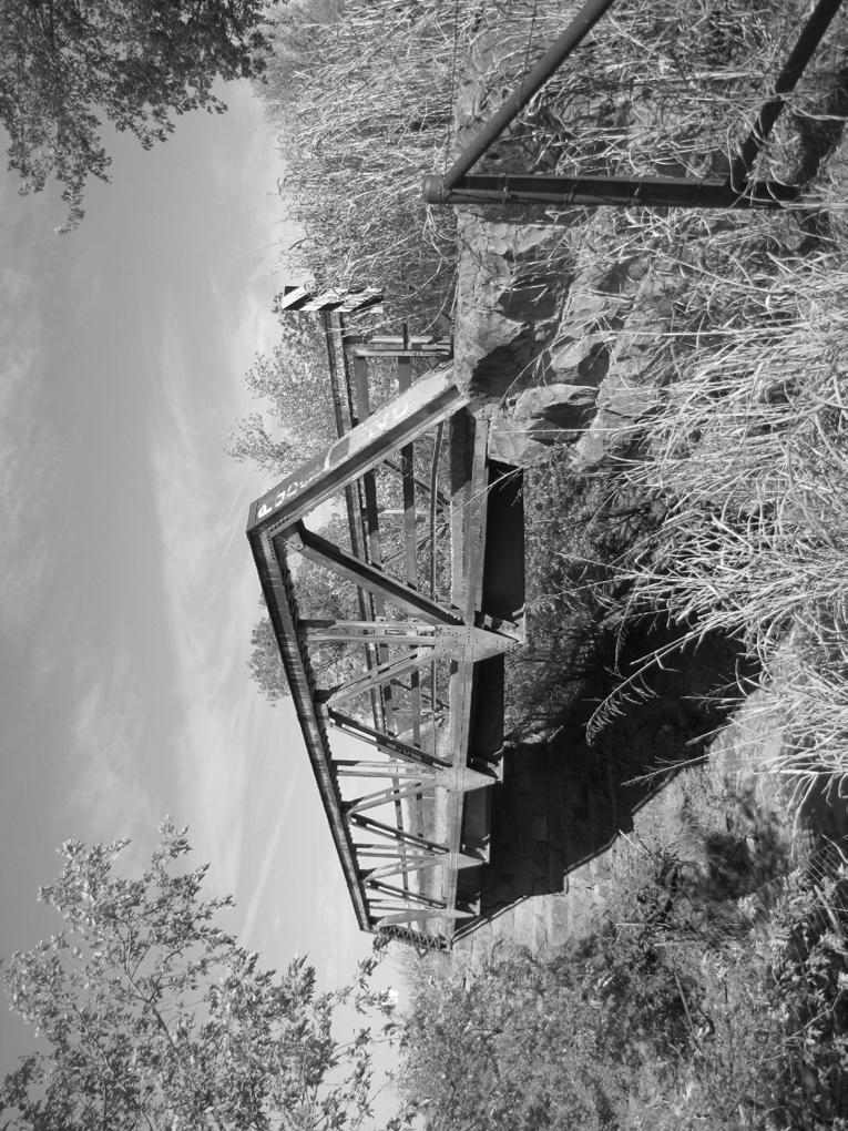
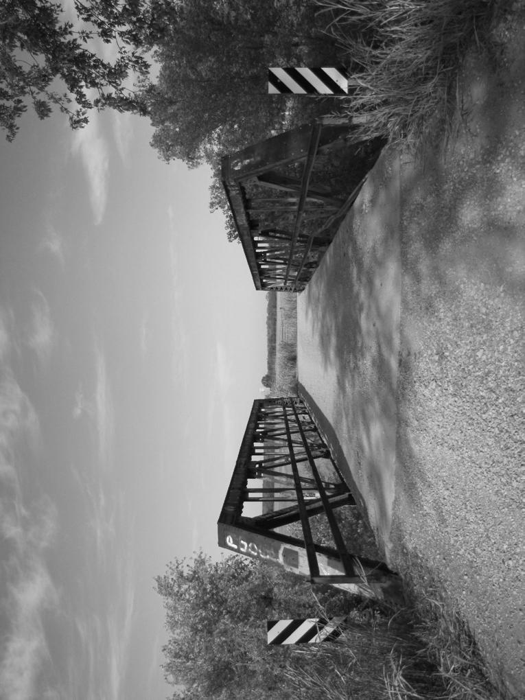
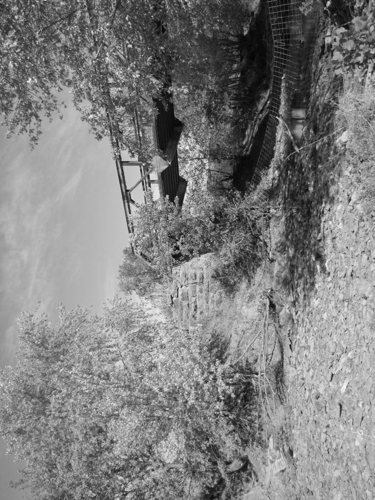
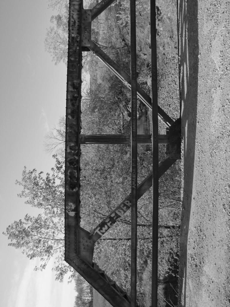
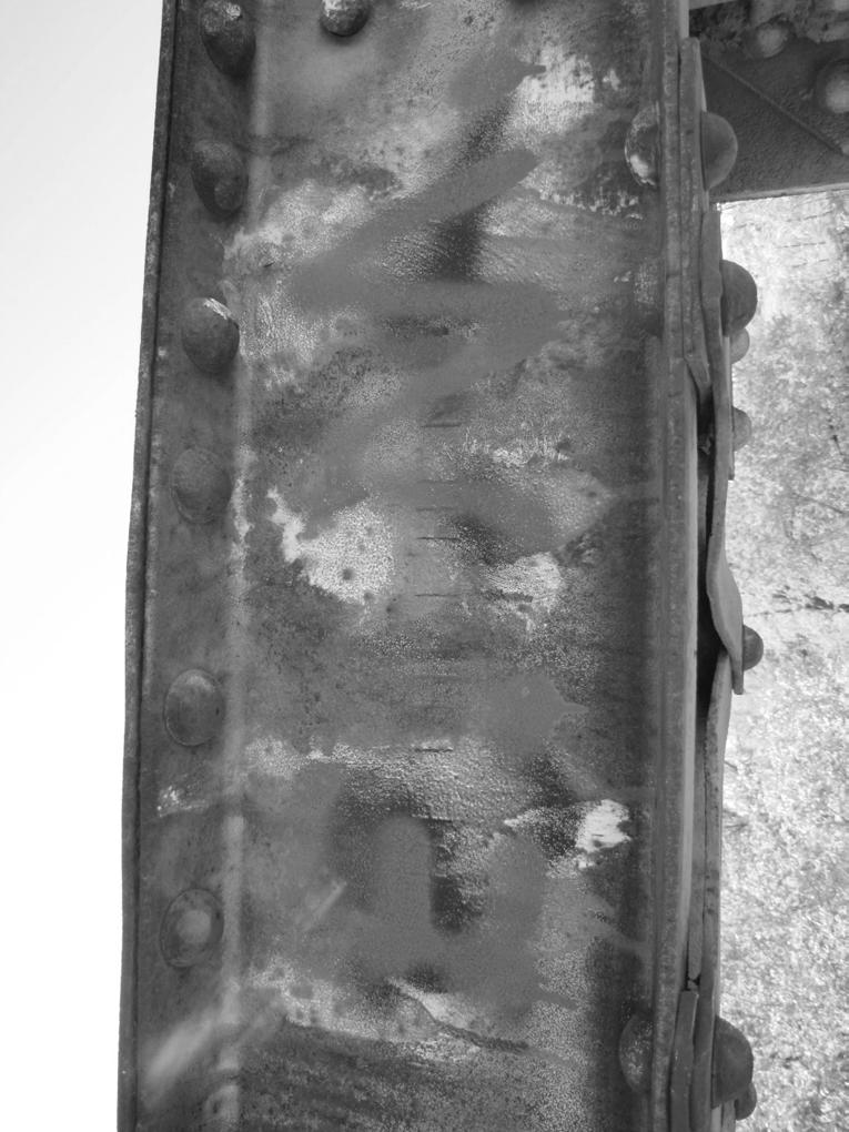
3 HISTORIC AMERICAN ENGINEERING RECORD INDEX TO PHOTOGRAPHS COON CREEK WARREN WITH VERTICALS PONY TRUSS Spanning Coon Creek Hulah Vicinity Osage County Oklahoma INDEX TO BLACK AND WHITE PHOTOGRAPHS Tanya McDougall, Photographer, October OVERALL VIEW, LOOKING SOUTHWEST 2. OVERALL VIEW, LOOKING EAST 3. OVERALL VIEW, LOOKING NORTH 4. VIEW OF SOUTHEAST END, LOOKING NORTHWEST 5. VIEW OF SOUTHEAST END, LOOKING WEST 6. VIEW OF NORTHWEST END, LOOKING SOUTH 7. VIEW OF NORTHWEST ABUTMENT, LOOKING EAST 8. VIEW OF SOUTHEAST ABUTMENT, LOOKING NORTH 9. DETAIL OF DIAGONAL MEMBERS, LOOKING NORTHEAST 10. DETAIL OF VERTICAL MEMBER, LOOKING SOUTHWEST 11. DETAIL OF V-LACING CONNECTING STRUCTURAL MEMBERS, LOOKING WEST 12. DETAIL OF PLAQUE, LOOKING SOUTHEAST 13. DETAIL OF STEEL COMPANY NAME BETHLEHEM, LOOKING SOUTHWEST
4 PHOTO 1

5 PHOTO 2
6 PHOTO 3
7 PHOTO 4

8 PHOTO 5

9 PHOTO 6

10 PHOTO 7
11 PHOTO 8

12 PHOTO 9
13 PHOTO 10

14 PHOTO 11

15 PHOTO 12
16 PHOTO 13
17 Spanning Coon Creek Hulah Vicinity Osage County Oklahoma WRITTEN HISTORICAL AND DESCRIPTIVE DATA
18 HISTORIC AMERICAN ENGINEERING RECORD COON CREEK WARREN WITH VERTICALS PONY TRUSS Location: Present Owner: Present Use: Significance: Spanning Coon Creek, at County Road 3011, in the Hulah vicinity, Osage County, Oklahoma. UTM: 14/E /N Quad: Bowring Osage County, Oklahoma ODOT Structure Number 57D3910E Vehicular Bridge The Coon Creek Warren with Verticals Pony Truss Bridge was constructed in , by the Rochester Bridge Company of Rochester, Indiana. The structure is a good example of its type and is a representative example of the work done by the bridge company s regional office located in Bartlesville, Oklahoma. Furthermore, the structure demonstrates a pattern of development associated with the oil industry in Osage County during the 1910s 1920s. Project Information: Historic American Engineering Record (HAER) Level II equivalent documentation was performed in October Tanya McDougall, Architectural Historian, conducted the on-site recordation and compiled the historical information. During the on-site recordation, photographs following National Park Service (NPS) standards for digital photography were taken of the structure, and observations on existing conditions were noted. The HAER recordation serves as mitigation for the demolition of this structure. List of Preparers: Historian/ Project Manager: Tanya McDougall Architectural Historian Geo-Marine Inc. Plano, Texas Principal Investigator: Field Assistant Editor: Report Production: Marsha Prior, Ph.D. Director of Historical Services Geo-Marine Inc. Plano, Texas Lindsey Skelton Geo-Marine, Inc. Plano, Texas Sharlene Allday Geo-Marine, Inc. Plano, Texas Denise Pemberton Geo-Marine, Inc. Plano, Texas
19 PART I. HISTORICAL INFORMATION A. Physical History: 1. Date of Construction: Architect/Engineer: Not Known COON CREEK WARREN WITH VERTICALS PONY TRUSS OSAGE COUNTY, OKLAHOMA (page 2) 3. Builder/Contractor/Supplier: Rochester Bridge Company 4. Original Plans: No original plans were found for this structure. 5. Alterations and Additions: The structure remains mostly unaltered except for missing railing on the northwest corner and replacement railing on the southeast corner of the truss. B. Historical Context: 1. Introduction Osage County, located in northeast Oklahoma, was named for the Osage Native American Tribe. The tribe, originally from Missouri, expanded its range in the 1760s to the area now known as Osage County. In 1839, the tribe was removed from its homelands and relocated to a reservation in Kansas. The Osage returned to the Oklahoma Territory in 1872 under the Cherokee Reconstruction Treaty of 1866 and established its tribal seat at Pawhuska. The area occupied by the Osage was designated a county in 1907, when Oklahoma was admitted as a state, and Pawhuska was designated the county seat (May 2011). With approximately 2,303 square miles, Osage County is Oklahoma s largest county in terms of size. Even so, an extensive agricultural industry never developed due to the land being inadequate for cultivation. However, the abundant natural grasslands had attracted cattlemen from throughout the southwest to the area since before statehood. With the Osage tribe having claim over the land, cattlemen had to negotiate grass leases with the tribal leasing committee. In 1898, the Osage were leasing 431,640 acres of land, which increased to 727,260 by 1901 (May 2011). Extensive grass leasing ceased after statehood and allotment in After statehood, the cattle industry continued to contribute to the county s economic stability, but the discovery of oil defined the county s growth in the twentieth century. In 1897, the first commercial producing oil well was drilled east of Osage County at what is now Bartlesville in Washington County (Pawhuska Journal Capital 1996). The well tapped into the Bartlesville-Dewey Field, one of Oklahoma s major oil fields, 1 In June 1906, the Allotment Bill passed Congress and provided for the distribution of Osage land to all tribal members registered on the roll as of January 1, The land was distributed to tribal members in 1907, by allowing each member to select 160-acres in each of three selection drawings (Muskogee Times-Democrat [MTD] 24 February 1906). The allottee was granted the surface rights, which allowed him or her to sell or rent the land, but the subsurface rights were held in trust by the federal government for the Osage National Council.
20 OSAGE COUNTY, OKLAHOMA (page 3) which stretches into the northeast part of Osage County. Seven months later, the first producing oil well in Osage County was drilled and produced 20 barrels a day. Although not considered a gusher, the discovery sparked an interest in the county s petroleum resources and initiated the county s first oil boom, which lasted through the 1920s (Boyd 2002:98; Pawhuska Journal Capital 1996:11). As development of the oil industry continued to progress, it became more apparent that the available transportation routes in the area were not adequate. Oil companies operating in Osage County needed access to railroads in order to ship their product. Thus, in 1899, the Atchison Topeka and Santa Fe Railroad was persuaded to construct a line over the Caney River through Bartlesville to the refineries in Kansas City. With a reasonable means to transport their crude oil, a 2-inch pipeline was constructed to the depot in Bartlesville, and in May 1900, the first shipment of oil was sent to Kansas (Wallis 1988:87). During the early 1900s, oil production in Osage County quickly gained momentum. Between 1900 and 1906, oil production increased from 6,212 to five million barrels annually (Wallis 1988:87-89). The success of the oil industry continued over the following decades and peaked between 1913 and 1920 (Boyd 2002:98). In that time the population increased to over 20,000, boom towns developed, and hundreds of wells were drilled (Osage County Clerk [OCC] 1918:County Commissioner Minutes [CCM] 2:434). It was during this period of prosperity that the bridge over Coon Creek was constructed. 2. Development of the Coon Creek Warren with Verticals Pony Truss Bridge The Coon Creek Warren with Verticals Pony Truss Bridge was constructed in The bridge is located south of Hulah in northwest Osage County and carries County Road (CR) A 1909 topographic map of the area reveals the area was undeveloped and depicts CR 3011 as a light duty road running north and south over Coon Creek (U.S. Geological Survey [USGS] 1909). The road was part of a system of light duty and unimproved roads that was likely established for oil companies and local farmers to access more populated centers located to the east, including the towns of Bartlesville, Copan, and Dewey (USGS 1913). In 1919, during the peak of the oil industry, the Stanolind Pipeline Company pumping station was constructed 1 mile west of Hulah and approximately 2.5 miles northwest of the Coon Creek Bridge (Glenn 2007:4). With few other transportation outlets in the area, it is likely that the establishment of the pumping station spurred the need to improve the crossing at Coon Creek. On November 24, 1919, the Osage County Board of County Commissioners unanimously approved the construction of six bridges, including the bridge over Coon Creek. The contract for the construction of the Coon Creek Bridge superstructure was awarded to the Rochester Bridge Company for the amount of $4,700 (OCC 1919:CCM 2:598). Construction of the substructure was awarded to T. E. Smith for the amounts of $12.50 per cubic yard of stonework and $1.50 per cubic yard of excavating (OCC 1919:CCM 2:598). Construction of the bridge was completed in 1920 (OCC 1920:CCM 3:50).
21 OSAGE COUNTY, OKLAHOMA (page 4) The County Commissioner records indicate that bidding for the Coon Creek Bridge was only let to the Rochester Bridge Company. The reason for this is unknown, except for the fact that by 1919 the Rochester Bridge Company was a well established bridge builder in Osage County. 2 Furthermore, it appears that the Rochester Bridge Company, which was headquartered in Rochester, Indiana, had a regional office located in Bartlesville, Oklahoma, as is evidenced by the nameplate on the bridge that reads: BUILT BY ROCHESTER BRIDGE CO. BARTLESVILLE OKLA. Steel for the Coon Creek Bridge was purchased from the Bethlehem Steel Company, the name of which is stamped on the bridge s top chord. The structure was constructed as a Warren Pony Truss, which was a standard type used by bridge companies throughout Oklahoma and the U.S. The design of the Warren Pony Truss, which consists of a series of elongated W s, was favored by bridge companies for its quick installation. This bridge type proved ideal for secondary routes and moderately traveled roads (King 1993). Today, the Coon Creek Bridge continues to function as a vehicular bridge, and represents a period of growth and great prosperity spurred on by the local oil industry during the early part of the 1900s. PART II. STRUCTURAL/DESIGN INFORMATION A. General Description: The Coon Creek Warren with Verticals Pony Truss is a two-lane vehicular bridge facilitating CR The structure runs northeast and southwest to accommodate the south-flowing drainage of Coon Creek. The structure consists of one span with a concrete deck supported by stone abutments. The total length of the structure is 70 feet (ft) and the total width is 16 ft. The truss consists of five panels, inclined end posts, and vertical and diagonal members. The end posts and top chord consist of two channels with V-lacing, a common means of holding larger beams together. The eight diagonal and four vertical members consist of angels connected by stay plates. The entire structure is riveted together, and gusset plates are located at each connection. The structure has remained mostly intact with the exception of missing railing on the northeast corner and replacement metal pipe railing on the southwest corner. The original railing consisted of two channels running parallel along the truss. The structure has a 16-ft-wide concrete deck, seven metal stringers, and four metal floor beams. The entire structure is supported by stone abutments that measure approximately 6 ft in height and 16 ft in width. 2 Early examples of bridges constructed by the Rochester Bridge Company in Osage County are the bridge over Hominy Creek near Skiatook constructed in 1913 and the Pratt Truss Bridge over Bird Creek near Avant constructed in 1914 (Saunders 1985).
22 OSAGE COUNTY, OKLAHOMA (page 5) 1. Character: The Warren Truss design, first developed in 1848 by James Warren and Willoughby Monzoni, is considered one of the most common truss types. During the early twentieth century, the Warren Truss was found to be ideal for secondary and minimally traveled roads. The coursed stone abutments demonstrate a rustic aesthetic common during the 1920s. 2. Condition of Fabric: The Coon Creek Warren with Verticals Pony Truss Bridge shows evidence of deterioration due to age and exposure to the elements. Noted deterioration includes a vertical crack on the southeast stone abutment, and an L-shaped crack on the northwest stone abutment. B. Site Information: The Coon Creek Warren with Verticals Pony Truss Bridge is located on a secondary road in a rural area. The landscape immediately surrounding the bridge is covered by native vegetation that follows the course of the creek. Beyond the native vegetation is open clearing used for grazing. No other structures are located near the bridge. PART III. SOURCES OF INFORMATION A. Primary Sources: Muskogee Times-Democrat (MTD) [Muskogee, Oklahoma] 1906 McGuire s New Bill for the Osage Nation. 24 February:3. Muskogee, Oklahoma. Osage County Clerk (OCC) 1918 County Commissioner Minutes. Book 2:434. Pawhuska, Oklahoma County Commissioner Minutes. Book 2:598. Pawhuska, Oklahoma County Commissioner Minutes. Book 3:50. Pawhuska, Oklahoma. U.S. Geological Survey (USGS) 1909 Pawhuska, Oklahoma. Pawhuska Quadrangle, 1:125,000. Map obtained from the Perry- Castañeda Library Map Collection, (Accessed January 4, 2011) Nowata, Oklahoma. Nowata Quadrangle, 1:125,000. Map obtained from the Perry- Castañeda Library Map Collection, (Accessed January 4, 2011). B. Secondary Sources: Boyd, D. T Oklahoma Oil: Past, Present, and Future. Oklahoma Geology Notes 62(3): Glenn, J. L Brief History of Hulah, Oklahoma, Osage County and Surrounding Area: Part 1 of 3. Bartlesville, Oklahoma.
23 OSAGE COUNTY, OKLAHOMA (page 6) King, J Spans of Time. Center for Historic Preservation and Technology, Texas Tech University. Sponsored by the Planning Division Oklahoma Department of Transportation, State of Oklahoma, and The Federal Highway Administration. May, J. D Osage County. (Accessed September 21, 2011). Pawhuska Journal Capital 1996 Oil in the Osage. Pawhuska, Oklahoma. Saunders, R. S Bridge Over Bird Creek. Historic American Engineering Record No. OK-2. Oklahoma Department of Transportation, Norman. Wallis, M Oil Man: The Story of Frank Phillips and the Birth of Phillips Petroleum. St. Martins Press, New York, New York.
24 Spanning Coon Creek Hulah Vicinity Osage County Oklahoma LOCATION MAP

25 OSAGE COUNTY, OKLAHOMA LOCATION MAP 17 '., \, I "
PHOTOGRAPHS AND WRITTEN HISTORICAL AND DESCRIPTIVE DATA
 Spanning Clear Creek Perkins Vicinity Payne County Oklahoma PHOTOGRAPHS AND WRITTEN HISTORICAL AND DESCRIPTIVE DATA HISTORIC AMERICAN ENGINEERING RECORD Submitted to: Oklahoma State Historic Preservation
State Level Historic Documentation Report. John Blue Bridge Hampshire County
 State Level Historic Documentation Report State Project No. S314-28-22.27 Federal Project No. BR-0028(058)D John Blue Bridge Hampshire County Prepared by: Randy Epperly, Historian Department of Transportation
HISTORIC AMERICAN ENGINEERING RECORD COVE CREEK SPILLWAY BRIDGE. HAER No. AR-83
 HISTORIC AMERICAN ENGINEERING RECORD COVE CREEK SPILLWAY BRIDGE LOCATION: Spanning Cove Creek Spillway at State Highway 309 (formerly Paris-Mt. Magazine Road), Corley vicinity, Logan County, Arkansas UTM:
United States Department of the Interior National Park Service. Boundary Expansion Listed in National Register January 11, 2017
 NPS Form 10900-a (Rev. 8/2002) OMB No. 10240018 United States Department of the Interior National Park Service Boundary Expansion Listed in National Register January 11, 2017 National Register of Historic
LAS VARAS RANCH CA COASTAL TRAIL PROPOSED ALIGNMENT
 LAS VARAS RANCH CA COASTAL TRAIL PROPOSED ALIGNMENT Santa Barbara Trails Council * Prepared by Ray Ford February 1,2012 The following notes accompany the Santa Barbara Trails Council map for the Las Varas
The Holes Creek Bridge Replacement By Bradley McClelland
 The Holes Creek Bridge Replacement By Bradley McClelland Each time there is a heavy rainstorm, the folks along Sheffield Road in the Dayton, Ohio suburb of West Carrollton have cause to be concerned. Holes
Elected Officials Briefing
 Elected Officials Briefing North Metro Rail Line February 12, 2015 1 Welcome and Introductions 2 Rick Clarke RTD Assistant General Manager Capital Programs 3 The RTD FasTracks Plan 122 miles of new light
Design Public Hearing for the Existing and Proposed Bridge Crossings on Aden Road (Rte 646) over the Norfolk Southern RR, Nokesville, Virginia
 over the Norfolk Southern RR, Nokesville, Virginia") Design Public Hearing for the Existing and Proposed Bridge Crossings on Aden Road (Rte 646) over the Norfolk Southern RR, Nokesville, Virginia September 18, 2013 Nicholas J. Roper, P.E. District Bridge
Design Public Hearing for the Existing and Proposed Bridge Crossings on Aden Road (Rte 646) over the Norfolk Southern RR, Nokesville, Virginia September 18, 2013 Nicholas J. Roper, P.E. District Bridge
The Covered Bridges of Preble County. Past, Present and Future By: R. Kyle Cross, P.E., P.S.
 The Covered Bridges of Preble County Past, Present and Future By: R. Kyle Cross, P.E., P.S. The History of the 8 Covered Bridges There are 8 covered bridges in Preble County. Only 2 of them are moved for
Flying W Guest Ranch. Oklahoma - Beckham County - Elk City
 Flying W Guest Ranch Oklahoma - Beckham County - Elk City 2 Flying W Guest Ranch is a well-known guest ranch in a historic location about 90 miles west of Oklahoma City near Elk City, Oklahoma. Situated
Figure San Dimas Bonita at San Dimas Avenue (view looking west)
") The adjoining neighborhood has an eclectic assortment of building types and uses, including: the historically significant but not architecturally or visually noteworthy San Dimas Lemon Association Packing
The adjoining neighborhood has an eclectic assortment of building types and uses, including: the historically significant but not architecturally or visually noteworthy San Dimas Lemon Association Packing
Hydraulic Report. Trail 5 Snowmobile Trail Over Mulligan Creek. Prepared By: COLEMAN ENGINEERING COMPANY Karisa V. Falls, P.E.
 Prepared for: Prepared by: Marquette County Road Commission Coleman Engineering Company Marquette, Michigan Iron Mountain, MI December 2011 Hydraulic Report Trail 5 Snowmobile Trail Over Mulligan Creek
OKLAHOMA HISTORIC BRIDGE SURVEY Phase 1 A Re-Evaluation of Spans of Time: Oklahoma Historic Highway Bridges
 OKLAHOMA HISTORIC BRIDGE SURVEY Phase 1 A Re-Evaluation of Spans of Time: Oklahoma Historic Highway Bridges Verdigris River 1925 Mixed Truss, Wagoner County Bird Creek 1912 Stone Arch, Osage County Oklahoma
National Register of Historic Places Registration Form
 NPS Form 10-900 OMB No. 10024-0018 (Oct. 1990) Registration Form This form is for use in nominating or requesting determinations for individual properties and districts. See instructions in How to Complete
MEMORANDUM. DATE: May 16, TO: Monica Harrower, PennDOT District 6-0. Mary Alfson Tinsman CHRS, Inc. 451 North Cannon Avenue, Suite 100B
 MEMORANDUM DATE: May 16, 2011 TO: Monica Harrower, PennDOT District 6-0 FROM: RE: Mary Alfson Tinsman CHRS, Inc. 451 North Cannon Avenue, Suite 100B Lansdale, PA 19446 French Creek Parkway Project Phoenixville
Killam, Howard D., Missouri-Kansas-Texas Railroad Depot and Locomotive/Rolling Stock, Photographic prints,
 Pittsburg State University Pittsburg State University Digital Commons Finding Aids Special Collections 1-2012 Killam, Howard D., Missouri-Kansas-Texas Railroad Depot and Locomotive/Rolling Stock, Photographic
SHELBY RANCH. unique places. Offered By: real estate
 SHELBY RANCH Offered By: SHELBY RANCH The Shelby Ranch is a great opportunity to acquire 702 +/- acres of northern New Mexico property that is less than 1.5 hours from Albuquerque and Durango and offers
Mr. Michael Malone CPS Energy 145 Navarro Street San Antonio, Texas Project No
 January 15, 2016 Mr. Michael Malone 145 Navarro Street San Antonio, Texas 78205 Project No. 0328985 Environmental Resources Management CityCentre Four 840 West Sam Houston Pkwy N. Suite 600 Houston, Texas
Final Drainage Letter Pikes Peak Community College Downtown Parking Lot Colorado Springs, Colorado
 Final Drainage Letter Pikes Peak Community College Downtown Parking Lot Colorado Springs, Colorado Prepared for: Pikes Peak Community College 5775 South Academy Boulevard Colorado Springs, CO 80906-5422
Hwy Retaining Wall/ Sea Wall. Not Eligible, see Statement of Significance Also member of listed NR district: Mantorville Historic District
 Historic Name CS # 2007 Other Name SHPO Inv # Location E and W sides of TH 57 between 6th St and 7th St Hwy District Reference City/Township County Mantorville, City of Dodge Acres Twp Rng Sec 107N 16W
North Portal of Jenson Tunnel 1998 Richard E. Napper, MMR
 A publication devoted to the Frisco Railroad, Prototype and Modeling Volume 5 Number 1 March 2013 North Portal of Jenson Tunnel 1998 Richard E. Napper, MMR The Meteor is published quarterly in PDF format
Gardner: overview. Santa Fe, Oregon, and California National Historic Trails UNINCORPORATED JOHNSON COUNTY OLATHE UNINCORPORATED JOHNSON COUNTY
 Santa Fe, Oregon, and California ational Historic Trails : overview 99: p.134 100: p.135 GARDER JUCTIO 102: p.137 56: p.126 EDGERTO Burlington orthern Intermodal and Logistics 98: p.133 101: p.136 S Waverly
Subject to Sale, Withdrawal or Error
 We are proud to offer an exclusive listing on a ranch in a very highly desired part of Northeast New Mexico. This ranch truly expresses the long understood real estate requirements of location, location,
Section 106 Update Memo #1 Attachment D. Traffic Diversion & APE Expansion Methodology & Maps
 Section 106 Update Memo #1 Attachment D Traffic Diversion & APE Expansion Methodology & Maps I-65/I-70 North Split Interchange Reconstruction Project (Des. Nos. 1592385 & 1600808) Traffic Diversion and
Lidar Imagery Reveals Maine's Land Surface in Unprecedented Detail
 Maine Geologic Facts and Localities December, 2011 Lidar Imagery Reveals Maine's Land Surface in Unprecedented Detail Text by Woodrow Thompson, Department of Agriculture, Conservation & Forestry 1 Introduction
OKLAHOMA HISTORY OKLAHOMA S GEOGRAPHY
 OKLAHOMA HISTORY OKLAHOMA S GEOGRAPHY BOARD QUESTIONS 1) HOW BIG IS OKLAHOMA? 2) HOW MANY COUNTIES ARE IN OKLAHOMA? 3) HOW FAR IS IT FROM OKC TO LAS ANGLES, CALIFORNIA? 4) HOW MANY STATE BORDER OKLAHOMA?
I I I I LINDEN TO WOOD FORD SURVEY ITEMS OF HISTORICAL SIGNIFICANCE I I I I I I I I I I I I I
 LNDEN TO WOOD FORD SURVEY TEMS OF HSTORCAL SGNFCANCE ------------------------------------------------------------------------------ --- - CONTENTS OF THE REPORT 1.0 ntroduction to the Report 1.1 Parameters
P3 & Design-Build. 101 st Annual THE Conference February 25 th, Speaker: Andrew Gensch, P.E.
 P3 & Design-Build 101 st Annual THE Conference February 25 th, 2015 Speaker: Andrew Gensch, P.E. Presentation Outline Ohio River Bridges Project Overall Discussion Downtown Crossing and East End Locations
Lake Manitou Dam and Spillway Upgrade
 South Bend Lake Manitou Dam and Spillway Upgrade Fort Wayne Rochester Indiana 1828 to 2017 Lafayette Sky Medors, P.E., LFA David Nance, P.G., IDNR Project Background Location: Rochester Indiana, Central
STATE OF WASHINGTON ARCHAEOLOGICAL SITE INVENTORY FORM
 STATE OF WASHINGTON ARCHAEOLOGICAL SITE INVENTORY FORM Smithsonian Number: 45 County: Chelan Date: 6/12/2018 Human Remains? DAHP Case No.: Archaeological Sites are exempt from public disclosure per RCW
Appendix L Technical Memorandum Aesthetics
 Technical Memorandum Aesthetics 1.0 AESTHETICS This section provides a discussion of the aesthetic resources in the vicinity of ARTIC. Aesthetics pertain to the elements that make a certain view pleasing
HEADQUARTERS WEST LTD. PHOENIX - TUCSON - SONOITA - COTTONWOOD - ST. JOHNS
 Offered for sale exclusively by: Walter Lane Headquarters West, Ltd. PO BOX 37018 Tucson, AZ 85740 Phone (520) 792-2652 info@headquarterswest.com www.headquarterswest.com General Area Description The Crown
HYDROLOGY OF GLACIAL LAKES, FORT SISSETON AREA
 PROC. S.D. ACAD. SCI., VOL. 77 (1998) 59 HYDROLOGY OF GLACIAL LAKES, FORT SISSETON AREA Perry H. Rahn Department of Geology & Geological Engineering South Dakota School of Mines and Technology Rapid City,
INLAND STEEL COMPANY, INDIANA HARBOR WORKS PHOTOGRAPHS,
 Collection # P 0711 INLAND STEEL COMPANY, INDIANA HARBOR WORKS PHOTOGRAPHS, 1926 Collection Information 1 Historical Sketch 2 Scope and Content Note 3 Contents 4 Processed by Dalton Gackle July 2018 Manuscript
Arrowhead Ranch. Located in the Big Range Country of Central Wyoming.
 Arrowhead Ranch Located in the Big Range Country of Central Wyoming. 58 E. Benteen Street Buffalo, WY 82834 Ph 307-684-9556 Toll Free 888-684-9557 Fax 307-684-8565 Location The ranch is approximately:
ALPINE PIPELINE RIVER CROSSINGS 2009 MONITORING REPORT
 ALPINE PIPELINE RIVER CROSSINGS 2009 MONITORING REPORT Submitted to ConocoPhillips Alaska, Inc. Submitted by Michael Baker, Jr., Inc. 1400 West Benson Blvd., Suite 200 Anchorage, Alaska 99503 TABLE OF
Offices at the Crossing at Telfair 300 Promenade Way, (Highways 6 & 90) Sugar Land, TX 77478
 Sugar Land, TX 77478") Offices at the Crossing at Telfair 300 Promenade Way, (Highways 6 & 90) Sugar Land, TX 77478 Last Updated 8/6/2018 Work & play at this dynamic mixed-use development Multiple restaurants at your door-step
Offices at the Crossing at Telfair 300 Promenade Way, (Highways 6 & 90) Sugar Land, TX 77478 Last Updated 8/6/2018 Work & play at this dynamic mixed-use development Multiple restaurants at your door-step
Introduction to Topographic Maps
 Introduction to Topographic Maps DIRECTIONS: Read all of the following content. READ EVERYTHING!! At the end of the packet, you will find two topographic maps. Your task is to indentify each of the elevations
Settlement Patterns West of Ma ax Na, Belize
 SETTLEMENT PATTERNS WEST OF MA AX NA, BELIZE 1 Settlement Patterns West of Ma ax Na, Belize Minda J. Hernke Faculty Sponsor: Kathryn Reese-Taylor, Department of Sociology/Archaeology ABSTRACT The focus
Chapter 8: Colorado Plateau State Highway 141, Dove Creek to Naturita
 State Highway 141 Dove Creek to (61 miles) Summary: Highway 141 heads north from US Highway 491 about two miles northwest of the town of Dove Creek. Initially, the highway runs through gently rolling farming
Phoenix Sky Harbor transit guideway bridge
 Phoenix Sky Harbor transit guideway bridge by David A. Burrows, Gannett Fleming The evolution of the PHX Sky Train s crossing of Taxiway Romeo At one of the 10 busiest airports in the United States, cast-in-place,
Pottstown postcard from the early 1960s. History compiled by Thomas Hylton
 Over a 250-year period, Pottstown has evolved into one of the loveliest small towns in Pennsylvania. The borough reached its economic zenith about 1960 and continued to prosper through the mid 1970s, when
Access to the site is obtainable from the paved driveway leading to the MWD facility.
 County of Riverside Public Safety Enterprise Communication Project Appendix A: Candidate Site Descriptions Overview The site is located adjacent to a Metropolitan Water District (MWD) facility on El Sobrante
APPENDIX K: BUILT HERITAGE AND CULTURAL HERITAGE LANDSCAPES
 APPENDIX K: BUILT HERITAGE AND CULTURAL HERITAGE LANDSCAPES TABLE 1: Built Resources (BHR) and Cultural Heritage Landscapes (CHL) Within and Adjacent to the West Whitby Secondary Plan Area Site # 1. CHL
CHAPTER 4 -- THE LAND USE PLAN: DESCRIPTIONS AND POLICIES FOR THIRTEEN PLANNING AREAS
 CHAPTER 4 -- THE LAND USE PLAN: DESCRIPTIONS AND POLICIES FOR THIRTEEN PLANNING AREAS NORTH CENTRAL CAC AREA LITTLE VALLEY ROAD TO JUG HANDLE CREEK PLANNING AREA This planning area includes Cleone, Noyo,
Port MacKenzie Rail Extension
 Port MacKenzie Rail Extension Project The Matanuska-Susitna Borough (MSB) and the Alaska Railroad Corporation (ARRC) jointly propose construction and operation of a new rail line to connect the Borough
SWINGING OVER SCHUYLKILL THE HISTORY OF THE PW&B AND BRIDGE NO. 31
 THE SWINGING OVER SCHUYLKILL THE HISTORY OF THE PW&B AND BRIDGE NO. 31 The Philadelphia, Wilmington & Baltimore Railroad Company (PW&B) was formed in 1836. In 1838, the railroad was enlarged by the joining
Historic Property Report
 Historic Name: Shadle Park Reservoir Property ID: 708465 Location Address: Location Comments: GeographicAreas: 4302 N Belt St, Spokane, Washington, USA Wellesley Ave & N Belt St Spokane,T25R42E01,SPOKANE
Attachment G STREAM IMPACTS. Ridge Road Extension Alternatives Analysis
 Attachment G STREAM IMPACTS for: Ridge Road Extension Alternatives Analysis PREPARED FOR: Pasco County Engineering Services Department PREPARED BY: NV5, INC. 6989 E. FOWLER AVENUE TAMPA, FLORIDA 33617
Addendum - Airport Development Alternatives (Chapter 6)
") Bowers Field Addendum - Airport Development Alternatives (Chapter 6) This addendum to the Airport Development Alternatives chapter includes the preferred airside development alternative and the preliminary
Bowers Field Addendum - Airport Development Alternatives (Chapter 6) This addendum to the Airport Development Alternatives chapter includes the preferred airside development alternative and the preliminary
HISTORICAL MARKERS issued by
 HISTORICAL MARKERS issued by INDIANA HISTORICAL BUREAU in MONTGOMERY COUNTY, INDIANA 2016 Compiled by Dian Moore, Montgomery County historian NUMBER NAME 54.1962.1 Lane Place 54.1963.1 Major General Lew
Holiday Extravaganza in Grand Central USA!
 Holiday Extravaganza in Grand Central USA! Day 1 St Louis Arrive in St Louis and begin with a tour of the Old Courthouse, the 25 foot Christmas tree is always a focal point during the holidays. Check into
Trench 91 revealed that the cobbled court extends further to the north.
 Report on the 2013 Gournia Excavations The 2013 excavations at Gournia were conducted June 17 July 26 under the aegis of the American School of Classical Studies at Athens and the supervision of the KD
SECTION 3 GENERAL DESCRIPTION OF THE RIVER BASIN
 SECTION 3 GENERAL DESCRIPTION OF THE RIVER BASIN SECTION 3 GENERAL DESCRIPTION OF THE RIVER BASIN River basin description. A general description of the river basin or subbasin, as appropriate, in which
Brinker Creek Ranch. Colorado - Routt County - Yampa
 Located at the base of the Flattops Range in the Steamboat/Vail corridor, Brinker Creek Ranch consists of 1,451 acres ideally suited for high country grazing and native grass hay production. Traditionally
Airport Planning Area
 PLANNING AREA POLICIES l AIRPORT Airport Planning Area LOCATION AND CONTEXT The Airport Planning Area ( Airport area ) is a key part of Boise s economy and transportation network; it features a multi-purpose
 Page 1 Original Update HISTORICAL STRUCTURE FORM FLORIDA MASTER SITE FILE Consult Guide To Historical Structure Forms for detailed instructions Site # 8OR9844 Recorder # 26 Recorder Date 2/20/08 Site Name
SAN MIGUEL CREEK RANCH. q Trinidad, Las Animas County, Colorado q
 SAN MIGUEL CREEK RANCH q Trinidad, Las Animas County, Colorado q 2 s San Miguel Creek Ranch is a scenic well-balanced cattle and trophy hunting ranch that showcases the very best of Southern Colorado.
Silver Creek Plunge Campground Reconstruction
 Silver Creek Plunge Campground Reconstruction PROPOSED ACTION REPORT Emmett Ranger District Boise National Forest 1805 Highway 16, Room 5 Emmett, Idaho 83617 November 2009 Silver Creek Plunge Campground
Projected Advertisement Date
 2013 Planned s CY 2013 and CY 2014 Richmond District Schedule Preliminary Engineering Task Order Contracts SR 288/SR 145 Survey, 288 90349 Chesterfield Ramp and Signal Design 2/27/2013 $ 0.19 I-64 Over
Panama Canal Stakeholder Working Group Meeting
 Panama Canal Stakeholder Working Group Meeting POHA, Bayport Container Terminal, Houston, Texas August 27, 2012 TOTAL ECONOMIC IMPACT 9,749 Texas jobs are in some way related to the Port Of the 9,749
Dufferin Jog Elimination Project
 Project Project Status Update November 14 2007 Project History Planning Alternatives Criteria Measured Project Benefits Structural Configurations Considered Structural Design Considerations The Preferred
Table 1: Santiago Peak Communication Site. Latitude 1 Longitude 1 Elev 2 Address T/R/S 3 APN 4 USGS Quadrangle
 County of Riverside Public Safety Enterprise Communication Project Appendix A: Candidate Site Descriptions Overview The site is located in the Cleveland National Forest (CNF) at an existing communication
Bridge Highest Railway.
 Opinion. The big news to-day is that the bridge over the canyon is complete, and the first train will cross tomorrow. Some may remember a short time ago when the rail line ended at the edge of the gorge,
Port MacKenzie Rail Extension
 Port MacKenzie Rail Extension Project The Matanuska-Susitna Borough (MSB) and the Alaska Railroad Corporation (ARRC) jointly propose construction and operation of a new rail line to connect the Borough
Trail Feasibility Study
 VOLUSIA COUNTY MPO CITY OF NEW SMYRNA BEACH FINAL REPORT JUNE 30, 2009 Trail Feasibility Study What s inside? 1 Introduction 2 Project Purpose & Scope 3 Physical Inventory & Assessment of Right-of- Way
THE ALBERTA GAZETTE, SEPTEMBER
 VILLAGE OF CEREAL Order No. 16915 IN THE MATTER OF THE "Municipal Government Act": File No. 241(A)3 AND IN THE MATTER OF an application by the Council of the Village of Cereal, in the Province of Alberta,
RAY YENKANA Willowbrook Cr, Dawson Creek BC Canada $2,847,000
 1716 Willowbrook Cr, Dawson Creek BC Canada For SALE $2,847,000 This is a rare find, 32 townhomes in Dawson Creek, BC. Excellent investment in a single title multi family complex. Vendor has upgraded this
Maryland Historical Trust Inventory No. PG: 86A-026 Maryland Inventory of Historic Properties Form
 Inventory No. PG: 86A-026 Maryland Inventory of 1. Name of Property (indicate preferred name) historic other 2. Location street and number 12811 Croom Road not for publication city, town Naylor vicinity
, CHARLES F. INTERVIEW.
 , CHARLES F. INTERVIEW. INDEX CARDS Ralston Churches Oklahoma- Territory Intruders Osage Reservation Ferries--Arkansas River Finance Oklahoma Territory, Game Osage Reservation Stage Routes Saloons Oklahoma
5/-of-~ National Register of Historic Places Registration Form. Bai1eyville
 NP' 'o'm 1HOO OMSNo. 1024-0Q18 IRev. 10/901 National Register of Historic Places Registration Form 1. Name of P;rope;rty Historic name; N/A Other name/site number; Clear Creek Camelback Truss Bridge (preferred);
WELCOME! TSPE DFW MID-CITIES. January Chapter Meeting
 WELCOME! TSPE DFW MID-CITIES Check-in/Networking Announcements / Lunch Service Speaker Presentation 11:30AM 12:00PM 12:00PM 12:15PM 12:15PM 1:00PM January Chapter Meeting Thank You to Our Sponsors Interested
Maryland Historical Trust Inventory No. PG: 86A-003 Maryland Inventory of Historic Properties Form
 Inventory No. PG: 86A-003 Maryland Inventory of 1. Name of Property (indicate preferred name) historic other 2. Location street and number 12005 Duley Station Road not for publication city, town Upper
Architectural Inventory Form
 OAHP1403 Rev. 9/98 COLORADO CULTURAL RESOURCE SURVEY Architectural Inventory Form Official eligibility determination (OAHP use only) Date Initials Determined Eligible- NR Determined Not Eligible- NR Determined
Overland Stagecoach Service through Tucson If it weren t for stagecoaches, Tucson wouldn t have developed to be the town we see today!
 Ring s Reflections by Bob Ring Overland Stagecoach Service through Tucson 1857-1880 If it weren t for stagecoaches, Tucson wouldn t have developed to be the town we see today! Let s set the stage (sorry).
National Register of Historic Places Multiple Property Documentation Form
 NPS Form 10-900-b OMB No. 1024-0018 Revised Aug. 2002 Expires 12-31-2005 Multiple Property Documentation Form This form is for use in documenting multiple property groups relating to one or several contexts.
Lake Wissota Access Locations within the LaFayette Township. By Chad Martin
 Lake Wissota Access Locations within the LaFayette Township By Chad Martin Anson/ Wissota Access Point # 1 Road: 195 th St. Associated Fire Numbers: 13294 Defining Characteristics: Forested from road
May - June 2003!" Vol. 25, No. 3. Newsletter of the Cultural Resources Division!" Kansas State Historical Society
 May - June 2003!" Vol. 25, No. 3 Newsletter of the Cultural Resources Division!" Kansas State Historical Society Over the years, Route 66 developed a mythical stature. While just over thirteen miles of
Bear Creek Habitat Improvement Project
 06/10/10 Bear Creek Habitat Improvement Project El Paso County, Colorado Pike National Forest and Colorado Springs Utilities Owned Land Report prepared by: Eric Billmeyer Executive Director Rocky Mountain
The Winding Valley and the Craggy Hillside
 The Winding Valley and the Craggy Hillside A History of the City of Rosedale, Kansas by Margaret Landis. Copyright 1976. All attempts have been made to reproduce the spelling, capitalization and layout
National Forests and Grasslands in Texas
 United States Department of Agriculture Forest Service National Forests and Grasslands in Texas Sam Houston NF 394 FM 1375 West New Waverly, Texas 77358 Phone 936-344-6205 Dear Friends, File Code: 1950
O HARA TOWNSHIP. Chapter 2 - Early History. Comprehensive Development Plan
 O HARA TOWNSHIP Chapter 2 - Early History The O Hara Township History Committee has assembled a significant volume of historical data from primary and secondary sources, about persons, places and events
GILBERT & WEST TOWN INTERCOUNTY DRAIN Windsor Township, Eaton County and City of Lansing, Delhi Township, Ingham County, Michigan
 GILBERT & WEST TOWN INTERCOUNTY DRAIN Windsor Township, Eaton County and City of Lansing, Delhi Township, Ingham County, Michigan PRELIMINARY ENGINEERING REPORT Abigail Eaton, Chair Intercounty Drains
MAGELLAN PIPELINE COMPANY, L.P. FERC TARIFF INDEX
 MAGELLAN PIPELINE COMPANY, L.P. FERC TARIFF INDEX This Index contains a list of FERC tariffs in effect as of July 1, 2017 Compiled By: Tina R. Granger, Pipeline Tariffs MAGELLAN PIPELINE COMPANY, L.P.
South Willow Creek Musselshell County Montana
 South Willow Creek Musselshell County Montana Clifton M. Berglee, D.V.M. (Listing Broker) 406-860-7319 cell cberglee@montwyowest.com Phone: (406) 628-2341 (office) Website: montwyowest.com P.O. Box 578,
Figure 1: Little Dry Creek Trail Crossing
 Figure 1: Little Dry Creek Trail Crossing Figure 2: Little Dry Creek Trail Crossing Northwest Rail Environmental Evaluation Temporary Trail Detour Concurrence Form Adams County, Little Dry Creek Trail
Resource & Relocation Guide
 County Ok 2017-2018 Resource & Relocation Guide Table Of Contents 4-5 Newcomer Information 6 Health & Hospitals 7 Local Education 9 Things To Do 10 State Information 11 County History 12-13 Tulsa County
State Route 8 Corridor. Northern Summit County s Path to Success
 State Route 8 Corridor Northern Summit County s Path to Success Construction Guide: 2008-2009 State Route 8 corridor work description State Route 8 Corridor 10 projects $262 million With its close proximity
KDOT announces approved November bids
 FOR IMMEDIATE RELEASE Nov. 25, 2013 News Contact: Kim Stich, 785-296-3585 KDOT announces approved November bids The Kansas Department of Transportation announces approved bids for state highway construction
OSAGE PRAIRIE TRAIL PLANS SKIATOOK TO PAWHUSKA
 OSAGE PRAIRIE TRAIL PLANS SKIATOOK TO PAWHUSKA U.S. Department of Transportation BUILD Transportation Discretionary Grant Program FY 2018 DUNS: 072406333 Rural Planning Grant Application Submitted by:
TRAILS END MOBILE HOME PARK
 KEITH WILSON CO. 4/23/2015 MOBILE HOME PARK REAL ESTATE BROKERAGE 2608 RISING STAR CELLULAR: (405) 414-9803 EDMOND, OK 73034 E-MAIL: kwilsonco@aol.com EXCLUSIVELY FOR SALE TRAILS END MOBILE HOME PARK 27700
2. Goals and Policies. The following are the adopted Parks and Trails Goals for Stillwater Township:
 D. PARKS AND TRAILS 1. Introduction Stillwater Township s population is relatively low, with most residents living on rural residences on large lots. The need for active park space has been minimal in
Historic Bridge Foundation Facebook Archives
 Historic Bridge Foundation Facebook Archives Did You Know That all of Budapest s bridges were bombed and nearly destroyed in World War II? August 2017 This might come as a surprise if you look at the bridges
BUILD. In this issue: NEW AERIALS OF CONSTRUCTION NEW PROJECT IN CONSTRUCTION PAC K AG E 4. August 2018
 BUILD C O N ST R U C T I O N Update August 2018 In this issue: NEW AERIALS OF CONSTRUCTION NEW PROJECT IN CONSTRUCTION PAC K AG E 4 AVENUE 12 CEDAR VIADUCT A VIEW FROM ROAD 27 ABOVE HSR CONSTRUCTION FRESNO
MAGELLAN PIPELINE COMPANY, L.P. FERC TARIFF INDEX
 MAGELLAN PIPELINE COMPANY, L.P. FERC TARIFF INDEX This Index contains a list of FERC tariffs in effect as of July 1, 2018 Compiled By: Tina R. Granger, Pipeline Tariffs MAGELLAN PIPELINE COMPANY, L.P.
MEMO TO STATE PUBLICATION PROGRAM LIBRARIES June 2, 2005
 MEMO TO STATE PUBLICATION PROGRAM LIBRARIES June 2, 2005 All expenses paid! Digital Archive Training! - We are planning a late July meeting and training session here in Santa Fe for any libraries interested
Native American Heritage in GRAND CENTRAL USA!
 Native American Heritage in GRAND CENTRAL USA! Day 1 Lawton OK Sulphur OK - Oklahoma City OK We begin our day with a tour of Fort Sill National Historic Landmark & Museum, a 19 th century frontier army
VOLUME II APPENDIX F DETAILED PHYSICAL DESCRIPTION OF PROJECT RESERVOIRS AND LANDS
 VOLUME II APPENDIX F DETAILED PHYSICAL DESCRIPTION OF PROJECT RESERVOIRS AND LANDS THE CENTRAL NEBRASKA PUBLIC POWER AND IRRIGATION DISTRICT FERC PROJECT NO. 1417 PHYSICAL DESCRIPTION OF PROJECT LANDS
VI. ALTERNATIVES TO THE MASTER PLAN C. RENOVATED EAST BUILDING ALTERNATIVE
 VI. ALTERNATIVES TO THE MASTER PLAN C. RENOVATED EAST BUILDING ALTERNATIVE INTRODUCTION The Renovated East Building Alternative would include the continued use of the renovated West Building and the renovation
CHAPTER 1 INTRODUCTION MORENO VALLEY GENERAL PLAN 1. INTRODUCTION. 1.1 What is a General Plan?
 1. INTRODUCTION 1.1 What is a General Plan? A General Plan is a comprehensive long-term strategy for the physical development of a city. It determines how land may be used and the infrastructure and public