Assessing Your Trails, Keeping Them Safe and Enjoyable
|
|
|
- Brenda Barrett
- 5 years ago
- Views:
Transcription


1 Jon Wood, PLA, ASLA Associate Vice President Stewart Bert Lynn, PLA, ASLA, LEED AP Project Manager Mecklenburg County Asset and Facility Management Assessing Your Trails, Keeping Them Safe and Enjoyable


2 Assessing Your Trails Do you have trails that are not being used regularly? Do your users feel your trails are safe? Is trail maintenance a problem? How often do you assess your trails?

3 Assessing Your Trails

4 Assessing Your Trails
5 Assessing Your Trails Evaluate & Assess CPTED for Trails Proper Trail Maintenance Assessing for Future Trails


6 Evaluate & Assess Planning the Assessment


7 Evaluate & Assess Survey current trail users What trail facilities are being used? What trail facilities are not? Why? Are users attracted to other trail systems further away? Why? Are there safety perceptions? Is maintenance an issue? How is trail access? How is trail connectivity?

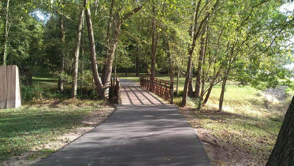
8 Evaluate & Assess Let s do an assessment Neighborhood connectivity? Trailhead/Access appeal? Maintenance of corridor? Maintenance/condition of trail surface? ADA? Visibility? Benches, trash cans, etc? Attractive for users? Feels safe for users? Distance to roadways? Distance to schools? Other? Rocky River Greenway

9 Evaluate & Assess Let s do an assessment

10 Evaluate & Assess


11 Evaluate & Assess Assessment Results - Issues Boardwalk/bridge structures not structurally sound Vegetation overgrowth Erosion problems Not enough destinations Narrow trail width Poor connectivity to neighborhoods Visibility problems


12 Evaluate & Assess Assessment Results - Opportunities Connectivity to schools Wildlife habitat Better definition of trail corridor Passive recreation nodes Trail extension?
13 Evaluate & Assess Addressing the issues Boardwalk/bridge structures not structurally sound Replacing all existing developer built structures with properly designed boardwalks and bridges Vegetation overgrowth Have cleared immediate underbrush, removed dead, decaying trees from immediate edge of corridor Erosion problems Amending existing gravel, converting to trail base with asphalt tread and gravel shoulders. Not enough destinations Have introduced fishing pier/outdoor classroom, picnic shelter, seating areas and rain garden Narrow trail width increased trail width from 6-8 wide to 10 wide with 12 gravel shoulders each side Poor connectivity to neighborhoods existing access points will be signed, grades addressed and paved. New access to Moss Farm Street and schools. Visibility problems A wider trail corridor has been cleared to give better visibility both along and to the greenway.
14 Evaluate & Assess Building on the Opportunities Connectivity to schools Trail awarded a Safe Routes to School grant to connect the neighborhoods to the schools and the schools to the environment. Wildlife habitat Introduction of an outdoor classroom and rain garden area expand environmental education curriculum. Better definition of trail corridor Widened trail and corridor opens visibility, more inviting to users; better perception of safety. Passive recreation nodes Introduction of seating areas, picnic shelter and environmental education facilities enhance the linear park. Trail extension? an additional half mile of greenway being added to existing corridor extending the trail to additional neighborhoods and sidewalks.
15 Assessing Your Trails Evaluate & Assess CPTED for Trails Proper Trail Maintenance Assessing for Future Trails
 To plan and design the")

16 CPTED for Trails Goal of Crime Prevention Through Environmental Design (CPTED) To plan and design the physical environment in order to reduce or eliminate opportunities for crime while improving the quality of life.
17 CPTED for Trails Objectives Encourage bicycle and pedestrian use Increase demand for greenways, parks and open space Encourage connectivity Enhance the visual quality of the experience Promote destinations

18 CPTED for Trails Key CPTED Concepts: 1. Natural Access Control 2. Natural Surveillance 3. Territoriality Definition 4. Activity Support 5. Management and Maintenance
 Guide trail")

19 CPTED for Trails 1. Natural Access Control (controls access) Guide trail users ingress, egress, and while on trails access points, fencing, landscaping, lighting Decrease opportunities for criminal activity Directional wayfinding
 Create visual")

20 CPTED for Trails 2. Natural Surveillance (increases visibility) Create visual connectivity between spaces and destinations Maximize visibility through placement of features, access and activities Feeling of observation reduces risk of crime Keep environment maintained


21 CPTED for Trails 3. Territoriality Definition (promotes a sense of ownership) Well designed trailheads and neighborhood access points Clear definition between private and public spaces


22 CPTED for Trails 3. Territoriality Definition (promotes a sense of ownership) Addition of fencing, signage, wayfinding, lighting, landscaping, special pavements, art, etc. Show that someone cares about this space
 Community events,")

23 CPTED for Trails 4. Activity Support (fosters community interaction) Community events, festivals, involvement in design and trail improvements, result in community interaction and ownership Encourage multiple group ownership Walk with a Doc More trail use(rs) = safer trail
 Adopt a trail")

24 CPTED for Trails 5. Maintenance & Management (deters offenders) Adopt a trail programs aid in maintenance and management, also in ownership Consistency is important Only build what you can maintain Someone cares what happens to this space!

 Limb up")


25 CPTED for Trails 5. Maintenance & Management (deters offenders) Limb up trees Create open spaces eyes on the trail Trim trees around lighting Thin out shrubs, brush Empty trash cans Replace furnishings Introduce gardens, color, artwork Create a Trail watch group
26 Assessing Your Trails Evaluate & Assess CPTED for Trails Proper Trail Maintenance Assessing for Future Trails

27 CPTED for Trails Key CPTED Concepts: 1. Natural Access Control 1. Trailheads 2. Neighborhood accesses 3. Parks 2. Natural Surveillance 1. Trim underbrush 2. Trail siting 3. Territoriality 1. Well defined spaces 2. Natural buffers 3. Fences/landscape buffers 4. Activity Support 1. Programming 5. Maintenance 1. Maintenance program
28 Proper Trail Maintenance Maintenance Focuses: Environment The Tipping Point Malcolm Gladwell New York City Crime Broken Windows Theory by Wilson and Kelling If a broken window remains unrepaired, passers by assume no one cares and no one is in charge Leads to more crime
29 Proper Trail Maintenance Maintenance for Safety Proper maintenance will: Show trail is cared for Maintain facility investment Ensure longevity Maintain safe and consistent trail surface Maintain visual corridors and trail clearances


30 Proper Trail Maintenance Build with Maintenance in Mind Trail Tread Don t skimp Use the right trail material Ensure proper location Observe construction


31 Proper Trail Maintenance Build with Maintenance in Mind Shoulders Clear enough space Clear the right material Make grades manageable Know your equipment

32 Proper Trail Maintenance Build with Maintenance in Mind Environment Standard finishes and furnishings Build to last Use proven methods Know the capabilities of your crew


33 Proper Trail Maintenance Maintenance Focuses: Regular Episodic Annual Long-term Maintenance Areas: Trail Tread Shoulders Environment
34 Proper Trail Maintenance Regular Maintenance Paved Evaluate drainage Clear trail Trail Tread Nature Surface Evaluate drainage Soft spots Clear trail Cut the grass Pick-up litter Shoulders Trim overgrowth Evaluate visibility Pick-up litter Empty trash Pet waste stations Graffiti and vandalism Environment Empty trash Pet waste stations Graffiti and vandalism

35 Proper Trail Maintenance Episodic Maintenance
36 Proper Trail Maintenance Episodic Maintenance Paved Clear trail tread Washouts Trail Tread Nature Surface Washouts and erosion Downed limbs/trees Washed litter Shoulders Downed limbs/trees Washed litter Graffiti and vandalism Debris at crossings Fixtures Environment Graffiti and vandalism Fixtures
37 Proper Trail Maintenance Annual Maintenance Paved Assessment Leaf removal Tread and structure repair Assessment Trim and clear underbrush Larger vegetation removal Assessment Structure and trailhead repair Trail Tread Shoulders Environment Nature Surface Assessment Tread repair Trail re-route Assessment Trim and clear underbrush Larger vegetation removal Assessment Structure and trailhead repair
38 Proper Trail Maintenance Long-Term Maintenance Paved Trail surface replacement Trail structures Trail Tread Nature Surface Tread repair Trail re-route Trail structures Grading improvements Structure repair Trailhead improvements New amenities Shoulders Environment Larger vegetation removal Grading improvements Structure repair Trailhead improvements New amenities

39 Proper Trail Maintenance Maintenance Example 1 Carolina Thread Trail Programmed and maintained by various entities Carolina Thread Trail City/town/county governments Non-profit/community organizations Volunteer based labor lead by key personnel Advantage: lower annual costs Disadvantage: less frequent maintenance, coordination

40 Proper Trail Maintenance Maintenance Example 2 Mecklenburg County Mecklenburg County Park and Recreation Department Program and Maintain Operational budgets, CIP, grants, and transportation funding Dedicated maintenance staff Advantage: Frequent and consistent care Disadvantage: higher annual costs, personnel dependent, equipment requirements


41 Proper Trail Maintenance Maintenance Example 3 Pocatello, Idaho Portneuf Greenway Trail System Multi-faceted approach: City of Pocatello Public Works City of Pocatello Parks & Recreation Portneuf Greenway Foundation Adopt-A-Reach groups Community service organizations and volunteers

42 Proper Trail Maintenance Maintenance Example 3 Chart designates responsibilities and schedules Advantage: spreads responsibility, fosters community Disadvantage: communication ing.org/maintenanc eplan.pdf


43 Proper Trail Maintenance Maintenance Tips Build it right the first time Budget for maintenance Know the capabilities of your crew Get users involved Don t be afraid to ask for help Make a plan and follow it

44 Assessing Your Trails Evaluate & Assess CPTED for Trails Proper Trail Maintenance Assessing for Future Trails

45 Assessing For Future Trails Downtown Connector Greenway, Concord NC

46 Assessing For Future Trails


47 Assessing For Future Trails Downtown Connector Greenway, Concord NC


48 Assessing For Future Trails Downtown Connector Greenway, Concord NC
49 Assessing Your Trails Questions/Sharing
50 Assessing Your Trails Jon Wood, PLA, ASLA Bert Lynn, PLA, ASLA, LEED AP
MORGAN CREEK GREENWAY Final Report APPENDICES
 APPENDICES MORGAN CREEK GREENWAY Appendix A Photos of Existing Conditions in Trail Corridor Photos of existing conditions Main trail corridor - February 2009 Photos of existing conditions south bank Morgan
Understanding user expectations And planning for long term sustainability 1
 Understanding user expectations And planning for long term sustainability 1 What is a natural surface trail? It can be as simple has a mineral soil, mulched or graveled pathway, or as developed as elevated
Chapter 6: POLICY AND PROCEDURE RECOMMENDATIONS
 Chapter 6 POLICY AND PROCEDURE RECOMMENDATIONS FOR SRRA Below are seven policy elements that should be considered for adoption by the Southwest Regional Recreation Authority of Virginia: 1. Develop strategies
City of Durango 5.8 FUNDING TRAILS DEVELOPMENT
 5.8 FUNDING TRAILS DEVELOPMENT The City has been successful in establishing dedicated local funding sources as well as applying for grants to develop the City s trail system, having received nearly $2.4
PIONEER PARK. City of Des Peres Parks Master Plan. SWT Design 46 INTRODUCTION
 PIONEER PARK INTRODUCTION Pioneer Park is a 7 acre neighborhood park located east of Interstate 270 and south of Manchester Road along Tallie Road. The park is situated in a residential neighborhood with
Appendix 3. Greenway Design Standards. The Whitemarsh Township Greenway Plan
 Appendix 3 Greenway Design Standards This chapter discusses two design standards for the greenway types discussed above. First, trail design standards are presented together with trailhead facilities and
Port Gamble Shoreline Area Conceptual Trail Proposal
 The North Kitsap Trails Association is pleased to be a partner to the Kitsap Forest and Bay Project and assist Kitsap County, Forterra, Olympic Property Group, Great Peninsula Conservancy and the Port
River Parks Trail: Tulsa, Oklahoma
 River Parks Trail: Tulsa, Oklahoma Purpose: The purpose of the River Parks Trail is to maintain, preserve, develop, and promote the Arkansas River for the economic and cultural benefit of the community.
METROPOLITAN COUNCIL 390 North Robert Street, St. Paul, MN Phone (651) TDD (651)
 TDD (651)") METROPOLITAN COUNCIL 390 North Robert Street, St. Paul, MN 55101 Phone (651) 602 1000 TDD (651) 291 0904 DATE: June 19, 2007 TO: Metropolitan Parks and Open Space Commission FROM: Jan Youngquist, Senior
METROPOLITAN COUNCIL 390 North Robert Street, St. Paul, MN 55101 Phone (651) 602 1000 TDD (651) 291 0904 DATE: June 19, 2007 TO: Metropolitan Parks and Open Space Commission FROM: Jan Youngquist, Senior
Auburn Trail / Ontario Pathways Trail Connector Feasibility Study Public Information Meeting Wednesday, August 22, 2012
 Auburn Trail / Ontario Pathways Trail Connector Feasibility Study Public Information Meeting Wednesday, August 22, 2012 Purpose of Feasibility Study Purpose Evaluate the feasibility of constructing a multiuse
Business Item No
 Metropolitan Parks and Open Space Commission Meeting date: February 6, 2018 For the Community Development Committee meeting of February 20, 2018 For the Metropolitan Council meeting of February 28, 2018
3. COLTA / HUGA CONNECTIONS - PRELIMINARY
 9 3. COLTA / HUGA CONNECTIONS - PRELIMINARY 3.1 COLTA The Chain of Lakes Trail Association (COLTA) trail, formerly identified as the Chester Spur Line, was completed and opened for use in June 2011. The
The Baker/Carver Regional Trail is intended to
 Section V Design Guidance The Baker/Carver Regional Trail is intended to safely accommodate 183,000 annual visits, an array of non-motorized uses, a variety of skill levels, and persons with special needs.
Adopt a Trail Blue Ridge Parkway
 Adopt a Trail Blue Ridge Parkway THANK YOU Thank You for volunteering to maintain a trail with the Adopt-A-Trail program! You are helping to keep these trails open for public use and enjoyment. We couldn
Citrus Heights Creek Corridor Trail Project Trail Advisory Group Field Trip #2 September 11, :00 11:00 am Trellis Hall, Citrus Heights
 September 11, 2013 9:00 11:00 am Trellis Hall, Citrus Heights Project Overview The City of Citrus Heights is studying the feasibility of establishing a multi use trail system within the City s 26 miles
CRANE LAKE TRAILS NETWORK AND SPACES
 CRANE LAKE TRAILS NETWORK AND SPACES AREA TRAILS COMMUNITY TRAILS GOLD COAST TRAIL LAKE PARK OPTION ONE LAKE PARK OPTION TWO OVERFLOW TRAILHEAD PARKING THE GATE AREA TRAILS Trails are a major resource
AGENDA ITEM 5 D WAKULLA ENVIRONMENTAL INSTITUTE (WEI) TRAIL FEASIBILITY STUDY
 TRAIL FEASIBILITY STUDY") March 19, 2018 AGENDA ITEM 5 D WAKULLA ENVIRONMENTAL INSTITUTE (WEI) TRAIL FEASIBILITY STUDY TYPE OF ITEM: Action STATEMENT OF ISSUE The Wakulla Environmental Institute (WEI) Trail is one of several trails
March 19, 2018 AGENDA ITEM 5 D WAKULLA ENVIRONMENTAL INSTITUTE (WEI) TRAIL FEASIBILITY STUDY TYPE OF ITEM: Action STATEMENT OF ISSUE The Wakulla Environmental Institute (WEI) Trail is one of several trails
FEASIBILITY CRITERIA
 This chapter describes the methodology and criteria used to evaluate the feasibility of developing trails throughout the study areas. Land availability, habitat sensitivity, roadway crossings and on-street
17 Mathilda Welmering Park Planning Zone 3
 17 Mathilda Welmering Park Planning Zone 3 8301 Mathilda Visit Date: September 2016 St. Louis County Parks Master Plan Page 1 Description: The six acre Mathilda Welmering Park is named for two streets
Rating: 5.0 (scale of 1-10)
") 95 Community Trail System Groundcover: 2-metre paved path, 1- metre grass buffer on either side. Location: Fort St. John Ownership: City of Fort St. John Rating: 5.0 (scale of 1-10) Strategic value: Linear
95 Community Trail System Groundcover: 2-metre paved path, 1- metre grass buffer on either side. Location: Fort St. John Ownership: City of Fort St. John Rating: 5.0 (scale of 1-10) Strategic value: Linear
$866,000. $1,400,000 Health Benefits $13,156,000 TOTAL ANNUAL DIRECT BENEFITS. $10,890,000 Economic Benefits
 SINGING RIVER TRAIL Trails Create Value + Generate Economic Activity Trails generate economic returns through improved health, safety, and environmental conditions, raise property values, and attract visitors.
Trail # NW Tuesday, June DESIGN. Provide an Review the Provide an. Project Goals: System system. wayfinding
 I. Welcome / Introductions Bethany Creek Trail #2 Segment 3 Neighborhood Meeting #1 Bethany Presbyterian Church 15505 NW Springville Road, Portland, OR 97229 Tuesday, June 26, 2018 @ 6:00PM Meeting Minutes
10.3 TRAIL DESIGN STANDARDS
 10.3 TRAIL DESIGN STANDARDS BICYCLE AND PEDESTRIAN MASTER PLAN Introduction This chapter provides guidelines to both public and private entities for the future development of various types of trails. The
Welcome to the future of Terwillegar Park a Unique Natural Park
 Welcome to the future of Terwillegar Park a Unique Natural Park 1 Introduction The Terwillegar Park Concept Plan study will develop an overall concept plan, management objectives and development guidelines
Lafourche Parish Government REQUEST FOR QUALIFICATIONS. Landscape Architectural Services
 Lafourche Parish Government REQUEST FOR QUALIFICATIONS Landscape Architectural Services Bayou Lafourche Parish Multi-Use Path Feasibility Study Phase 1 And Bayou Lafourche Parish Multi-Use Path Feasibility
Dryden Rail Trail Friends and Task Force Monday, January 21, :00 9:00 p.m. Dryden Town DPW 61 East Main Street, Dryden
 Agenda Dryden Rail Trail Friends and Task Force Monday, January 21, 2019 7:00 9:00 p.m. Dryden Town DPW 61 East Main Street, Dryden Call to order (7:00 p.m.) Bob Beck Additions to agenda Approval of December
Advertising, Sponsorship, Directional, and Wayfinding Signage on Multi-Use Trails Policy
 DRAFT ( ) Advertising, Sponsorship, Directional, and Wayfinding Signage on Multi-Use Trails Policy Prepared for: SATS Multi-Use Trails Jurisdictions Committee Table of Contents Introduction... 3 Signage
Understanding the caring capacity of the visitor experience Provide facilities to support a high level user experience Address visual quality through
 Understanding the caring capacity of the visitor experience Provide facilities to support a high level user experience Address visual quality through recreation ecological restoration opportunities Collaboration
The following trails completed their work utilizing funds awarded by the Greenways Foundation:
 The Greenways Foundation Grant Awards 2013 and 2014 Our grant program has been in place since 2012 and is funded entirely by the proceeds received through our Indiana BMV specialty license plate. Please
Georgetown-Lewes Rail/Trail Study. Rail/Trail Study: Cool Spring to Cape Henlopen State Park New Road Extension (House Resolution No.
 Georgetown-Lewes Rail/Trail Study Rail/Trail Study: Cool Spring to Cape Henlopen State Park New Road Extension (House Resolution No. 47) August 22, 2011 Presentation Outline Background Benefits Statewide
Logo Department Name Agency Organization Organization Address Information 5700 North Sabino Canyon Road
 Logo Department Name Agency Organization Organization Address Information United States Forest Coronado National Forest 5700 North Sabino Canyon Road Department of Service Santa Catalina Ranger District
35 Bee Tree Park Planning Zone 3
 35 Bee Tree Park Planning Zone 3 2701 Finestown Road Visit Date: August 2016 St. Louis County Parks Master Plan Page 1 35 Bee Tree Park 2701 Finestown Road St. Louis County Parks Master Plan Planning Zone
Rule Governing the Designation and Establishment of All-Terrain Vehicle Use Trails on State Land
 Rule Governing the Designation and Establishment of All-Terrain Vehicle Use Trails on State Land 1.0 Authority 1.1 This rule is promulgated pursuant to 23 V.S.A. 3506. Section 3506 (b)(4) states that an
Dungeness Recreation Area County Park Master Plan
 Dungeness Recreation Area County Park Public Outreach Meeting October 10, 2007 Project Overview USFWS Site Dungeness Recreation Area County Park Meeting Objectives: Re-Introduce project; provide status
PEMBERTON VALLEY RECREATIONAL TRAILS MASTER PLAN UPDATE Community Open House. April 2018
 PEMBERTON VALLEY RECREATIONAL TRAILS MASTER PLAN UPDATE Community Open House April 2018 Introductions Introductions Matt Bakker, BHA Project Coordinator Other Team Members: Liz Scroggins, Grey Owl Consulting
J. Recreation Plan of Conservation and Development. The Town of Hebron. Section 2. Preservation of Unique Assets. 1 P a g e
 The Town of Hebron Section 2 2014 Plan of Conservation and Development Preservation of Unique Assets J. Recreation Open spaces, parks, sports fields, and recreational programs are considered essential
CHAPTER 5. Chapter 5 Recreation Element
 CHAPTER 5 Recreation Element Chapter 5 Recreation Element The Recreation Element of the Meyers Area Plan is a supplement to the Recreation Element of the TRPA Regional Plan and the El Dorado County General
General Fund. Parks, Recreation, and Community Services. Fiscal Year 2017
 Parks, Recreation, and Community Services Mission: The mission of the City of Rio Rancho s Department of Parks, Recreation, & Community Services is to create and maintain spaces and activities that grow
Volunteer Project Trip Report Yosemite National Park May 16-20, 2012
 Conservation Volunteers International Program 120 Village Square #9 Orinda, California 94563 USA www.conservationvip.org A Non-Profit 501c3 Tax Exempt Organization CST 2089890-40 Volunteer Project Trip
Blue River Trail Master Plan JSA to Town Hall June 2004
 Blue River Trail Master Plan JSA to Town Hall June 2004 Prepared for: Silverthorne Town Council Silverthorne SPORT Committee Department of Recreation and Culture Silverthorne Public Works Silverthorne
Wilds. Headwaters. Lakes. Oxbows. Falls
 56 5 4 3 Wilds Headwaters Lakes Oxbows Falls 57 Zones It could be said the on-the-ground essence of this master plan appears within the next 6 pages of this report. As we learned in the preceding Cultural
2. Goals and Policies. The following are the adopted Parks and Trails Goals for Stillwater Township:
 D. PARKS AND TRAILS 1. Introduction Stillwater Township s population is relatively low, with most residents living on rural residences on large lots. The need for active park space has been minimal in
Shelf Road Recreation Area 2015 BLM Annual Report of Rocky Mountain Field Institute Stewardship Under BLM Agreement L12AC20483 November 19, 2015
 Summary Shelf Road Recreation Area 2015 BLM Annual Report of Rocky Mountain Field Institute Stewardship Under BLM Agreement L12AC20483 November 19, 2015 Managed by the BLM Royal Gorge Field Office, Shelf
COMMUNITY MEETING NOVEMBER 1, Wheaton Regional Park Pine Lake Trail
 COMMUNITY MEETING NOVEMBER 1, 2012 MEETING AGENDA I. Introduction of Project Team II. Trail Renovation Process III. Wheaton Regional Park IV. Pine Lake Trail Renovation Project V. Comments and Questions
SITKA SEA WALK CRESCENT HARBOR TENNIS COURTS TO SITKA NATIONAL HISTORICAL PARK
 SITKA SEA WALK CRESCENT HARBOR TENNIS COURTS TO SITKA NATIONAL HISTORICAL PARK October 10, 2011 Crescent Harbor tennis courts to Sitka National Historical Park Workshop Agenda 1.5 hours Project Introduction
Tallahassee-St. Marks Historic Railroad Trail
 Revitalizing a Historic Trail Designated as a National Recreation Trail, the 16-mile Tallahassee-St. Marks Historic Railroad Trail has been enjoyed by countless bicyclists, runners, and outdoor enthusiasts
Eliza Pool Park Master Site Plan
 Eliza Pool Park Master Site Plan Heather Sullivan North Carolina State University PRT 451(001) Table of Contents Executive Summary.3 Regional Analysis...4 Site Analysis...5 Physical Assessment 6 Program
Citrus Heights Creek Corridor Trail Project. Trail Advisory Group Meeting #3 July 8, 2013
 Citrus Heights Creek Corridor Trail Project Trail Advisory Group Meeting #3 July 8, 2013 Agenda Introductions Recap: Community Workshop, Survey Findings, and TAG Field Trip Community Concern Discussion:
Waukee Trailhead Public Art and Amenities Project
 Waukee - Trailhead Public Art and Amenities Project Sponsor Waukee Project Title Waukee Trailhead Public Art and Amenities Project Termini Description ( i.e. Park Avenue to 19th Street) NE Intersection
6.5 DURANGO EXCELS AT PARK CONNECTIVITY
 City of Durango 6.5 DURANGO EXCELS AT PARK CONNECTIVITY The City of Durango excels at park connectivity as evidenced by the success of the Animas River Trail (ART) project. While it is clear there are
INTRODUCTION. Mailing address: Burke County Community Development Attn: Tim Johnson P. O. Box 219 Morganton, NC
 REQUEST FOR QUALIFICATIONS: PROFESSIONAL, EXPERIENCED TRAIL BUILDERS FOR THE CONSTRUCTION OF THE FONTA FLORA STATE TRAIL LAKE JAMES SECTION BURKE COUNTY COMMUNITY DEVELOPMENT INTRODUCTION Burke County
Hudson Highlands Fjord Trail Draft Master Plan. April 29, 2015
 Hudson Highlands Fjord Trail Draft Master Plan April 29, 2015 Agenda Route Overview Proposed Segment Results of Community Survey on that Segment Next Steps Municipal Endorsement Environmental Review Implementation
Procedure for the Use of Power-Driven Mobility Devices on Mass Audubon Sanctuaries 1 September 17, 2012
 Procedure for the Use of Power-Driven Mobility Devices on Mass Audubon Sanctuaries 1 September 17, 2012 Background As part of Mass Audubon s mission to preserve the nature of Massachusetts for people and
The Vision for the San Juan Islands Scenic Byway
 The Vision for the San Juan Islands Scenic Byway 2 Judd Cove, Orcas Island, Courtesy of Kurt Thorson (kurtthorson.com) and San Juan County Land Bank Vision for the San Juan Islands Scenic Byway The San
Business Item No XXX. Proposed Action That the Metropolitan Council approve the Coon Creek Regional Trail Master Plan.
 Business Item No. 2015-XXX Metropolitan Parks and Open Space Commission Meeting date: July 7, 2015 For the Community Development Committee meeting of July 20, 2015 For the Metropolitan Council meeting
Group similar facilities together separate dissimilar facilities.
 Park design Principle #1 Group similar facilities together separate dissimilar facilities. Why do we do this? Safety Differences in admission fees Differences in seasonal use Reduce user conflicts Principle
EXECUTIVE SUMMARY FALL Introduction. Findings
 EXECUTIVE SUMMARY FALL 2004 Introduction Trails are one of the most popular and highly desirable recreational resources in communities of all sizes throughout the country. In addition to providing a safe
The Roots of Carrying Capacity
 1 Applying Carrying Capacity Concepts in Wilderness 1872 1964...shall be preserved for the use & enjoyment of the American people...in such manner as will leave them unimpaired for future generations...
Kit Carson-Challenger Ridge Trail Project
 Kit Carson-Challenger Ridge Trail Project Project Accomplishments Report-USFS December 15, 2015 Photo courtesy of Justin Peterson 815 South 25 th Street, Suite 101 Colorado Springs, CO 80904 Dedicated
MPRB: Southwest LRT Community Advisory Committee Issues and Outcomes by Location Current to: 12 November 2010
 MPRB: Southwest LRT Community Advisory Committee Issues and Outcomes by Location Current to: 12 November 2010 This is a compilation of issues and outcomes identified by the CAC. It is a work in progress,
Applying Carrying Capacity Concepts in Wilderness
 Applying Carrying Capacity Concepts in Wilderness...shall be preserved for the use & enjoyment of the American people...in such manner as will leave them unimpaired for future generations... CSS 490 Professor
11. Recreational Trails and Pathways Needs
 11. Recreational Trails and Pathways Needs Background Walking, biking, hiking, in-line skating, canoeing, and other trail- and pathway-related activities are important to Boiseans. This importance is demonstrated
Stephens State Park Trails
 TRAILS OF ALLAMUCHY MOUNTAIN & STEPHENS STATE PARKS Allamuchy Mountain and Stephens State Parks contain 28 marked trails providing access to diverse landscapes for walking, hiking, biking, bird-watching,
WASHINGTON STATE PARKS AND RECREATION COMMISSION POLICY/PROCEDURE
 WASHINGTON STATE PARKS AND RECREATION COMMISSION POLICY/PROCEDURE 65-13-1 Use of Other Power-Driven Mobility Devices by Persons with Mobility Disabilities at State Park Facilities See Also: 28 CFR 35 Title
Non-Motorized Transportation
 Non-Motorized Transportation Non-motorized facilities are important components to the transportation system. They provide an environmentally-friendly, low-cost mode of travel. Some of the facilities can
Corktown Parks. Public Meeting. City of Toronto
 Corktown Parks Public Meeting City of Toronto 15-04-20 Agenda 1. Reasons for Study 2. Consultation to Date 3. Parks Evaluation 4. Community Context 5. Bright St. Playground 6. Orphans Green (Dog Off Leash)
chapter - Hex Highway Touring Route Hamburg to Strausstown Overview
 chapter - 2 Hex Highway Touring Route Hamburg to Strausstown Overview The on-road Hex Highway automobile and bicycle touring route begins on State Street in downtown Hamburg. The route continues west on
Stainforth & Keadby Canal Installation of Multiuser Path
 Stainforth & Keadby Canal Installation of Multiuser Path Introduction North Lincolnshire Council has entered into an agreement with Canal & River Trust to develop proposals to introduce a multiuser path
Community Development Committee
 C Community Development Committee For the Metropolitan Council meeting of October 31, 2012 Committee Report Item:2012-316 ADVISORY INFORMATION October 16, 2012 Date Prepared: Subject: Intercity Regional
University Region Non-Motorized Plan 2015
 Non-Motorized Transportation Non-motorized facilities are important components to the transportation system. They provide an environmentally-friendly, low-cost mode of travel. Some of the facilities can
Hillsborough County Florida Hillsborough County s Trailways Addressing Program
 Hillsborough County Florida Hillsborough County s 9-1-1 Trailways Addressing Program 2010 ProBike/ProWalk Florida -Conference May 12-13, 2010 1 REQUEST Staff from the Hillsborough County Sheriff s Office
Triangle Land Conservancy Conservation Area Monitoring Report Carolina North
 Triangle Land Conservancy Conservation Area Monitoring Report Carolina North Property Name: Bolin Creek West Conservation Area Date of visit: March 16, 2017 County: Orange Property Type: Restrictive Covenants
Rogue River Access and Management Plan Draft Alternatives
 Rogue River Access and Management Plan Draft Alternatives The Rogue River Access and Management Plan was initiated in December, 2011 and is being led by Jackson County Parks (JCP) and Oregon Department
B10. Agate Beach State Recreation Site
 B10. Agate Beach State Recreation Site Location Within the City of Newport, just south of the Yaquina Head Outstanding Natural Area. The park is located along the west side of Highway 101 at the mouth
Trail Feasibility Study
 VOLUSIA COUNTY MPO CITY OF NEW SMYRNA BEACH FINAL REPORT JUNE 30, 2009 Trail Feasibility Study What s inside? 1 Introduction 2 Project Purpose & Scope 3 Physical Inventory & Assessment of Right-of- Way
Who is Beneficial Designs?
 Who is Beneficial Designs? Beneficial Designs works towards universal access through research, design, and education. We believe all individuals should have access to the physical, intellectual, and spiritual
Naming. Concept Design Phase. Confederation Park. Naming
 Branding Strategy Naming The name has been enhanced to include the word beach, with a visual emphasis on Beach Park. This strategy instantly communicates the differentiating context of this park within
Your Park Maintenance Prep
 Your Park Maintenance Prep 4 Ways to Rev Up for Opening Day For those outside of the hospitality business, off season sounds like vacation time for park owners. But anyone in the business knows that s
National Recreation Trail Application for Designation
 National Recreation Trail Application for Designation Introduction Thank you for your interest in the National Recreation Trail (NRT) program. Completed NRT application packages must be submitted by December
Jefferson County Non-Motorized Transportation and Recreational Trails Plan 2010
 Chapter 8: Goals and objectives Plan Update: The following update presents general principles, goals, and objectives related to non-motorized transportation facilities as a component of the overall transportation
Longmont to Boulder Regional Trail Jay Road Connection DRAFT FINAL REPORT
 Longmont to Boulder Regional Trail Jay Road Connection DRAFT FINAL REPORT December 2018 Project Summary Boulder County, Colorado, in partnership with the City of Boulder, is evaluating options for multi-use
Blueways: Rivers, lakes, or streams with public access for recreation that includes fishing, nature observation, and opportunities for boating.
 Parks, Open Space and Trails PRINCE WILLIAM COUNTY 2008 COMPREHENSIVE PLAN TRAILS PLAN CONTENTS The components of the trails plan are: Intent Definitions Goals, Policies, and Action Strategies Trails Map
Capital Prioritization
 14 Capital Prioritization 279 279 280 Park & Recreation CAPITAL PRIORITIZATION As described in Chapter 8, the recommendations presented in Chapter 9 are prioritized to provide a guide for future capital
Next Generation Cycleway Design. Improving connectivity and cycling behaviours through design
 Next Generation Cycleway Design Improving connectivity and cycling behaviours through design Safe segregation between Place Users to offer improved safety and a defined space for each user group Elevated
2013 Construction Accomplishments
 2013 Construction Accomplishments MOA Parks & Recreation Key Accomplishments in 2013 1. Over 10 Million Dollars in MOA Park Improvements 2. A Successful Volunteer Program with over 9,000 Volunteer Hours
Bear Creek Habitat Improvement Project
 06/10/10 Bear Creek Habitat Improvement Project El Paso County, Colorado Pike National Forest and Colorado Springs Utilities Owned Land Report prepared by: Eric Billmeyer Executive Director Rocky Mountain
Permeable RECREATIONAL TRAILS
 SMART EARTH SOLUTIONS Permeable RECREATIONAL TRAILS GEOWEB GEOPAVE GEOTERRA Innovative Solutions for Designing & Building Trails. Trail Surface Stabilization The key to planning and building trails into
A Message from the Director
 Lee s Summit Public Works Department Director Chuck Owsley Deputy Director & City Engineer Dena Mezger Deputy Director Administration & Operations Bob Hartnett Airport Manager John Ohrazda City Traffic
2. STAKEHOLDER FEEDBACK // What We Heard
 1. QUARRY ROAD TRAIL // Welcome to the Information Session PROJECT DESCRIPTION WHY WE ARE HERE Quarry Road Trail is a popular commuter trail and recreational area for Calgarians. 1. To report citizen feedback
BACK COUNTRY UNIT PREFERRED ALTERNATIVE
 BACK COUNTRY UNIT PREFERRED ALTERNATIVE San Francisco (118 mi) Carmel-By-The-Sea Carmel River Carmel Valley Road State Beach Private Property Point Lobos State Reserve Point Lobos Ranch RUSTIC CAMPING
Committee. Presentation Outline
 CW-33-15 11/9/2015 Community and Corporate Services Committee November 10, 2015 1 Presentation Outline Background Vision and Objectives Study Process and Timeline Public and Stakeholder Engagement Organization
City of Haslett. City of East Lansing. City of East Lansing
 Central Park North (Nancy L. Moore Park) Lake Park North Expansion White Park Expansion #2 White Park Expansion #1 County East East Haslett East East TF87-212 Acquisition $90,000.00 Park. TF08-138 Acquisition
LEAVE NO TRACE CENTER FOR OUTDOOR ETHICS CONSULTING SERVICES
 LEAVE NO TRACE CENTER FOR OUTDOOR ETHICS CONSULTING SERVICES LEAVE NO TRACE PURPOSE Americans love the outdoors. Today, more than 300 million people visit America s national parks and another 150 million
National Recreation Trail Update Form
 National Recreation Trail Update Form Introduction Thank you for taking the time to complete this form. Your assistance will help ensure that the National Recreation Trail (NRT) database is complete and
DRAFT - APRIL 13, 2007 ROUTING STUDY FOR TRAIL CONNECTIONS BETWEEN CALAIS AND AYERS JUNCTION
 DRAFT - APRIL 13, 2007 ROUTING STUDY FOR TRAIL CONNECTIONS BETWEEN CALAIS AND AYERS JUNCTION Abstract The vision for the East Coast Greenway is an off-road urban trail system running from Calais, Maine
Dover Park Master Plan. Community Design Event Tuesday, May 22, 5 7 pm
 Dover Park Master Plan Community Design Event Tuesday, May 22, 5 7 pm Agenda I. Introduction / Overview 20 minutes II. Small Group Design Activity 60 minutes III. Small Group Report Out IV. Conclusion
Lake Myra County Park. Wake County, North Carolina Community Forum #2 June 12, 2008
 Lake Myra County Park Wake County, North Carolina Community Forum #2 June 12, 2008 Welcome and Introduction Meeting Agenda Welcome Introductions of Project Team Master Plan Process Community Forum #1 Updates
Canal Steward Program Adoption Package
 National Park Service U.S. Department of the Interior Chesapeake and Ohio Canal National Historical Park 1850 Dual Highway, Suite 100 Hagerstown, MD 21740 301-745-5810 phone 301-739-6179 fax Canal Steward
9. GUIDELINES. General Park Guidelines
 General Park Guidelines The purpose of the General Park Guidelines is to provide a framework for developing future Queen Creek parks. The Guidelines will help define those elements that the Town would
Colorado Springs & Pikes Peak Region Destination Master Plan
 Colorado Springs & Pikes Peak Region Destination Master Plan Overview June 19, 2018 DESTINATION MASTER PLAN What is Destination Master Planning? Focus on infrastructure, facilities, services, attractions