Brazilian Counterpoint: Nomads, Traders, and Slaves
|
|
|
- Blaise Washington
- 5 years ago
- Views:
Transcription

1 Thomas Holloway, History, UC Davis Brazilian Counterpoint: Nomads, Traders, and Slaves Empire to Empire: The Americas in the Age of Exploration CLAS Summer Institute for Teachers UC Berkeley, July14-16, 2008
2 Brazil in the Age of Expansion (plan for this presentation) Indigenous Peoples: Hunters and gatherers (Jê speakers) retreat from hunters and farmers (Tupi speakers) before Europeans arrive Portuguese maritime pioneers: navigation, ship design, cartography; a network of aggressive trade The plantation complex: European demand (for sugar), American land, African labor How the west was won: Brazil comes to occupy half of South America


3 Indigenous Peoples Today Today the indigenous population of Brazil is about 300,000, or.02% of the national total. About 12% of the national territory is in Indigenous Reserves. There are 206 different tribes speaking 170 distinct languages. Only 10 groups have more than 5,000 members.


4 Ethnohistorians believe that speakers of Jê languages were pushed to the interior of the continent by groups speaking Tupi, who were still expanding north to south and east to west when Europeans arrived around Language Families

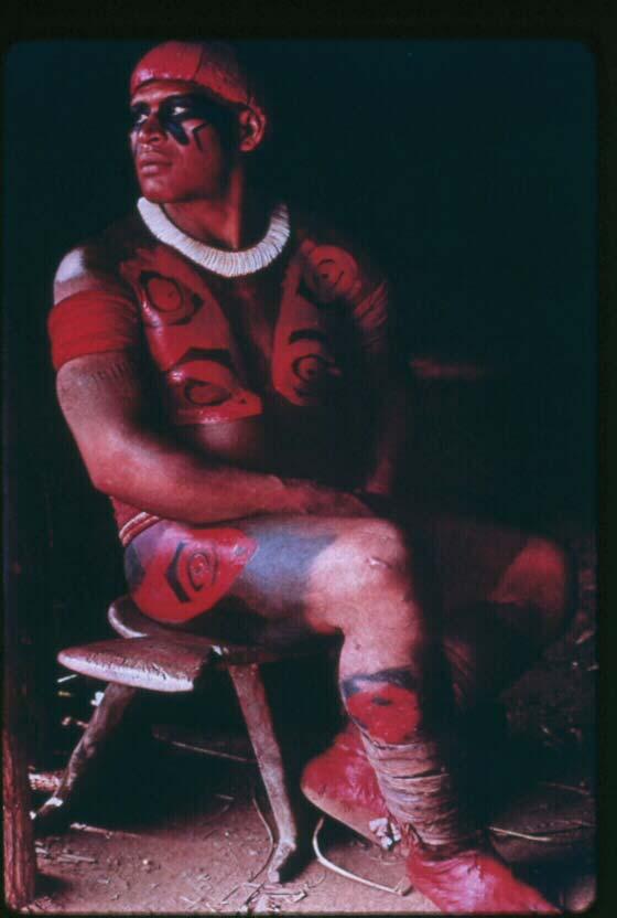

5 Waura From near the Venezuelan border.


 Pounding")
6 Tchikao people, Xingu park Subsistence Making manioc flour (farinha de mandioca) Pounding corn Beiju (manioc cakes)


7 Subsistence Pirarucu Fishing Learning to hunt


8 Shifting Villages A Jê speaking group In Xingu park Villages are abandoned and rebuilt a few miles away every few years, as soil and hunting are depleted.


9 Ceremonies Nambikwara Bororo

10 Portugal emerges The Christian retaking of the Iberian peninsula from the Muslims left Portugal an independent kingdom by 1143, recognized by the Pope in 1179, and territorially complete by Aljubarrota Portuguese independence from Castile was confirmed in 1385, at the battle of Aljubarrota.
11 Technical Innovations Mapmaking --where things are in relation to other things, in distance and direction Navigation aids --how to find one s location on the globe in relation to other points, and how to reach the other points Naval architecture --how make a ship that will get there and back, with a cargo that will pay for the trip

.")
12 Maps from Medieval Europe These stylized T in O maps, based on religion more than astronomy or cartography, show Jerusalem at the center of the world (and the east at the top--the origin of orientation ). Augsburg, 1472 Hereford Mappamundi,1300
13 Maps of the Renaissance This map from 1482, is adapted from the work of Ptolemy (about 150. It shows the world known to Europeans before the Age of Expansion.

14 The Compass A magnetized needle, used not just to find North, but to maintain a bearing (direction) in relation to North. It was known in China in ancient times, and first used in Europe in the 1200s.
 in relation to the horizon.")
15 The ASTROLABE was used for sighting the sun at its zenith (noon) or the North Star at night, to determine one s latitude (position north to south on the globe) in relation to the horizon. The Astrolabe
 in relation to the surface of the earth (by using the plumb line).")
16 The QUADRANT was used for sighting the sun or North Star, to determine one s latitude (position north to south on the globe) in relation to the surface of the earth (by using the plumb line). The Quadrant
17 north star Finding Latitude In practice, the curved surface of the earth appears as a flat horizon, and the angle between it and the North Star increases as one moves north from the Equator.
 and lateen (triangular) sails for maneuverability, making long-distance voyages practical.")
18 The Caravel was developed in Europe in the 1400s, combining relatively large hull capacity (also used in the Carrack and the Galleon) and lateen (triangular) sails for maneuverability, making long-distance voyages practical. Naval Architecture
 sails in the rear for maneuverability, including sailing into side winds.")
19 The Caravel A typical Caravel was about feet long and 20 feet across, and combined square sails in the front masts for speed with the wind,and lateen (triangular) sails in the rear for maneuverability, including sailing into side winds. (A replica of Columbus s second ship, the Niña, a caravel.)
20 Portugal Leads Maritime Expansion A seafaring tradition underpinned a consolidated monarchy after c A large Portuguese fleet occupied the north African port of Ceuta in Prince Henry The Navigator promoted exploration of Africa from his base in southern Portugal, from the 1420s to his death in 1460.
21 Portugal in West Africa After taking Ceuta in 1415, Portuguese Prince Henry launched trips down the African coast, beginning the black slave trade by the 1440s and seeking a route to the Far East. Ceuta, 1415 Cape Bojador, 1434 El Mina, 1481

22 Start of the African Slave Trade In this building in Lagos, southern Portugal, the first black slaves brought directly from subsaharan Africa were sold, brought by Gil Eanes in (Lagos, Nigeria is named for this town.)
23 Portuguese mariners seeking a sea route to India hit contrary conditions in the south Atlantic. Both currents and winds push north along the African coast. Around Africa Bartolomeu Dias, 1487 (5 years before Columbus sailed west)
24 Knowledge spreads quickly This map was produced in 1489 by Henricus Martellus, a German working in Florence, Italy, not long after Dias returned to Portugal in Dec The African coastline is complete to beyond the Cape of Good Hope.
25 Compared to a few years earlier Just 7 years difference.
26 Dividing the World After Columbus s trip in 1492 (red line) Spain and Portugal met at Tordesillas in 1494 and agreed on a line dividing non-christian territories between them (black line).
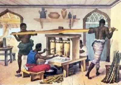
27 South Atlantic navigation To avoid the contrary currents along the African coast, Vasco da Gama,10 years after Dias, sailed to the south west, and caught currents that took him around the Cape of Good Hope to India. Bartolomeu Dias, 1487 Vasco da Gama, 1497
 landing Following Da Gama s trip 3 years later, Pedro Alvares Cabral took a similar route with a slightly different")
28 Accidental(?) landing Following Da Gama s trip 3 years later, Pedro Alvares Cabral took a similar route with a slightly different bearing, and bumped into Brazil in April Bartolomeu Dias, 1487 Vasco da Gama, 1497 Pedro Alvares Cabral, 1500


29 The Cantino Map, 1502 Drawn after the voyages of Columbus (for Spain), and Da Gama, Cabral, and the Corte-Real brothers (all for Portugal).

30 Este he o marco dantre castella y portuguall (Detail from the 1502 Cantino map)
31 A New World map Made by Martin Waldseemuller in Amerigo Vespucci is the figure in the upper right. The eastern coastline of America, including the Caribbean islands, shows at the left side.

32 America named Detail showing label America, on the Waldseemuller map of 1507.
33 A New Understanding In just 18 years, European understanding of the world changed dramatically.

34 Around the World With the first circumnavigation, by the Magellan (Magalhães)/ Del Cano in , the basic configuration was established. The fleet started with 5 ships and c. 240 men. One ship with 18 men survived.


35 The Portuguese Trading Empire By about 1550 the Portuguese had established some 50 trading bases (feitorias, often mistranslated as factories ) on three continents, including Brazil. In the 16th century the African and Asian trade was much more lucrative than was Brazil.


36 The dyewood phase -Pau Brasil The first economic activity by Portugal in Brazil was trading with the indigenous people for pau brasil, a native wood that produces a red dye used in coloring textiles.


37 Unsustainable extraction Extraction of pau brasil went on for about a century, and nearly brought the tree to extinction along Brazil s Atlantic forest. It also brought the natives in contact with Europeans and their trade goods--and weapons.
.")
38 Sugar By the 1530s sugar production began along the Brazilian coast, based on patterns already used in the Atlantic islands (Madeira and the Azores). An enclave economy using European capital, colonial land, African labor for European markets.


39 Slaves Brazil alone received some 40% of all slaves taken from Africa over more than 3 centuries, around four million people. (Vs. about 500,000 to British North America).


40 The Sugar Engenho (mill)
41 A United Kingdom (and colonies) Between 1580 and 1640, Spain and Portugal were united under one crown, so the border set at Tordesillas was not so important.

42 Erasing the Tordesillas line In the 1600s expeditions of Bandeirantes extended Portuguese influence through the interior of the continent, ignoring the line of demarcation set in 1494.


43 Bandeirantes The legend The reality

44 Monções ( Monsoons ) River-borne expeditions into the interior of the continent, named for the season when the rivers ran high--a term borrowed from the Indian Ocean experience.

45 How the West was won Both river and landbased expeditions established a Portuguese presence in the area not Occupied by the Spanish. Tordesillas line: Monções (river trips): Bandeirantes (overland trips):
, and San")
46 Borders redrawn Borders with Spanish America were realigned, in the Treaties of Madrid (1750), and San Ildefonso (1778).
47 Thomas Holloway, History, UC Davis Muito Obrigado pela Atenção! Empire to Empire: The Americas in the Age of Exploration CLAS Summer Institute for Teachers UC Berkeley, July14-16, 2008

48 Extra slides The following slides were deemed not essential to the presentation, and are placed here to remove them from the the body of the show, to save time and reduce sensory overload. I have left them in the PPT set in case anyone who uses this collection might find them of interest or useful. Tom Holloway, Dept. of History UC Davis <thhollow@ucdavis.edu>


49 Body Decoration Kraho Suya

50 The Crusades of the 1100s

51 Between 1347 and 1351, the bubonic plague killed about one-third of the population of Europe. The Black Death

52 On a clear night, point to the horizon with one arm, and point to the North Star with the other arm. Then measure the arc between your arms, in degrees. (Note: You ll probably need to have a friend help, and a really big protractor.) Guessing Latitude

 complete.")

53 A globe--with parts missing This globe was made by Martin Behaim in 1492, the same year Columbus first sailed west. After Dias, Africa was (fairly) complete. What s missing, between Europe and Cipangu was the American continent and most of the Pacific Ocean. (A flat version)

54 Boundary Disputes There were several attempts to fix the location of the Line of Demarcation described by the Treaty of Tordesillas.

55 Marking the Divide This monument in the southern Brazilian town of Laguna marks the position of the line of Tordesillas, according to the Portuguese).


56 The Slave Trade From Curtin, The Atlantic Slave Trade, 1969

57 Cabral left Lisbon with a fleet of 13 ships, lost5ontheway, sent one more home with news of the landfall in Brazil, and arrived in India with 7 ships. Only 4 of the 13 ships returned to Portugal in Risk and Reward
The Age of Exploration. It all began with Prince Henry the Navigator.
 The Age of Exploration It all began with Prince Henry the Navigator. Henry as The Navigator Henry never journeyed the sea Henry organized expeditions of sailors to explore the western coast of Africa In
Williams, John Garnons. (n.d.). A Map of World Exploration. Retrieved July 31, 2006 from:
. A Map of World Exploration. Retrieved July 31, 2006 from:") Williams, John Garnons. (n.d.). A Map of World Exploration. Retrieved July 31, 2006 from: http://www.explorers.enta.net/. Prince Henry the Navigator, of Portugal, is given credit for being the first to
Williams, John Garnons. (n.d.). A Map of World Exploration. Retrieved July 31, 2006 from: http://www.explorers.enta.net/. Prince Henry the Navigator, of Portugal, is given credit for being the first to
Unit 11 Lesson 9 Great Voyages of Discovery
 Unit 11 Lesson 9 Great Voyages of Discovery Generalization: Contact can lead to conflict and cultural diffusion Big Idea -- The Age of Discovery would not have been possible without the emergence of Spain
Chapter 10. Transoceanic Exploration (750 to 1500 CE)
") Chapter 10 Transoceanic Exploration (750 to 1500 CE) Muslim Domination of the Afro-Eurasian Region: 750 CE 1258 CE During the Abbasid Dynasty, Muslim rulers controlled most international trade routes in
Chapter 10 Transoceanic Exploration (750 to 1500 CE) Muslim Domination of the Afro-Eurasian Region: 750 CE 1258 CE During the Abbasid Dynasty, Muslim rulers controlled most international trade routes in
LEQ: What treaty divided Spanish territory in the new world from Portuguese territory?
 LEQ: What treaty divided Spanish territory in the new world from Portuguese territory? This map shows the voyages of Pedro Cabral in 1500, including when he was blown off course and landed in what is now
Christopher Columbus Birth: 1451 Death: 1506 Nationality: Italian Birthplace: Genoa, Italy
 Christopher Columbus Birth: 1451 Death: 1506 Nationality: Italian Birthplace: Genoa, Italy Early Life Christopher Columbus was born in Genoa, part of present-day Italy, in 1451. Christopher studied mapmaking
Age Of Exploration History Notes JC-Learn. JC-Learn. History Notes Age of Exploration. 1 P a g e
 JC-Learn History Notes Age of Exploration 1 P a g e Age of Exploration Reasons: (For Good, For God and For Glory). For Good: They wanted to find a route to Asia and the Spice Islands (Great Silk route
The gums of both the lower and upper teeth of some of our men swelled, so that they could not eat and therefore died.
 20 September 1519 Magellan Sets Sail for South America The First Circumnavigation of the Globe The gums of both the lower and upper teeth of some of our men swelled, so that they could not eat and therefore
PRESS PACK. April 29 to May 1 Brixham Harbour Town Pontoon NAO VICTORIA. The First Sailing Around The World
 April 29 to May 1 th Brixham Harbour Town Pontoon st NAO VICTORIA The First Sailing Around The World The Nao Victoria was Ferdinand Magellan s ship. Her name is associated with the greatest adventure in
Unit 8 SPAIN IN THE 15TH AND 16TH CENTURIES
 Colegio Bilingüe La Asunción Social Science 5º prim. Unit 8 Unit 8 SPAIN IN THE 15TH AND 16TH CENTURIES The Catholic Monarchs SPAIN IN THE 15TH AND 16 TH CENTURIES Isabel I of Castilla and Fernando II
Journey Around the World with the Universal Atlas of Fernão Vaz Dourado
 OCTOBER 28, 2018 BY MEDIEVALISTS.NET Journey Around the World with the Universal Atlas of Fernão Vaz Dourado By João Carlos Garcia This atlas was made in 1571 by one of the finest Portuguese cartographers,
COLUMBUS The First Trip: The Second Trip: The Third Trip: The Fourth Trip:
 SCURVY Long ago when men were exploring the world for the first time, they would travel on ships for months at a time with not a sign of land. They would bring food and fresh water along on board. Meat
Warm-up. A. Exports only manufactured goods B. Should import fewer products C. Needs to import more products D. Does not import or export
 Warm-up As with any small country, Cuba has fewer natural resources than countries such as Brazil. This affects their trade in that Cuba A. Exports only manufactured goods B. Should import fewer products
Vespucci world map #338
 Vespucci world map Title: Vespucci world map Date: 1526 Author: Juan [Giovanni] Vespucci Description: This large illustrated manuscript planisphere on vellum presents the first cartographic record of exploration
LATIN AMERICA. Mexico Central America Caribbean Islands South America
 LATIN AMERICA Mexico Central America Caribbean Islands South America HISTORY First Settlers Hunters/gatherers from Asia crossed land bridge connecting Asia and Alaska Learned to farm over time Maize (corn)
UNIT 3 Extra Review for Chapters 9-11
 UNIT 3 Extra Review for Chapters 9-11 Mexico Central America Caribbean Islands Middle America is Central America, Mexico, and the Islands of the Caribbean Central America is a region within Middle America.
Mediterranean Europe
 Chapter 17, Section World Geography Chapter 17 Mediterranean Europe Copyright 2003 by Pearson Education, Inc., publishing as Prentice Hall, Upper Saddle River, NJ. All rights reserved. Chapter 17, Section
Warm ups *What is unique about the status of Switzerland? *How Austria s history differed from that of Switzerland?
 Warm ups 12.07.2016 *What is unique about the status of Switzerland? *How Austria s history differed from that of Switzerland? Lesson Objective: *describe how Spain differs physically, economically, and
DOWNLOAD OR READ : WHO WAS FERDINAND MAGELLAN PDF EBOOK EPUB MOBI
 DOWNLOAD OR READ : WHO WAS FERDINAND MAGELLAN PDF EBOOK EPUB MOBI Page 1 Page 2 who was ferdinand magellan who was ferdinand magellan pdf who was ferdinand magellan Download who was ferdinand magellan
PRESS PACK. April 20 th - 25 th Trinity Landing Cowes Harbour NAO VICTORIA. The First Sailing Around The World
 April 20 th - 25 th Trinity Landing Cowes Harbour NAO VICTORIA The First Sailing Around The World The Nao Victoria was Ferdinand Magellan s ship. Her name is associated with the greatest adventure in the
In 1492 Columbus sailed the ocean blue. January 12, columbus SMART.notebook. Journey to the Americas. Nov 30 10:52 AM.
 Journey to the Americas Christopher Columbus Admiral Of The Ocean Sea (1451 5/20/1506) Nov 30 10:52 AM In 1492 Columbus sailed the ocean blue Christopher Columbus was an Italian mapmaker, explorer and
Late Middle Ages Institutional complexity o Custom o Complex property Rural and agrarian o Local production o Taboo against trade o Eastern trade
 Late Middle Ages Institutional complexity o Custom o Complex property Rural and agrarian o Local production o Taboo against trade o Eastern trade Venice o Powerful nobility Struggles of the crown o Against
Latin America 11/4/2013. Latin America Today. 580 million people 9% of the world s population Diverse backgrounds:
 Latin America Chapter 10 Human Geography Latin America Today 580 million people 9% of the world s population Diverse backgrounds: Native Americans Europeans Africans Asians 1 Population 393 million live
Brazil. Population & Culture
 Brazil Population & Culture Population of Brazil Largest country in South America 200 million people (2012 est) Growing population - approximately 1% per year Life expectancy - approx 72 years Population
CHRONOLOGY. of Colonialism in South America
 CHRONOLOGY of Colonialism in South America 1492 Columbus Sails for Spain Detail from: America Sive Novus Orbis, by Theodore de Bry, 1596 Image from: De Insulis nuper in mari Indico repertis, by Christopher
Victoria, the only ship of Magellan s fleet to complete the circumnavigation (from a 1590 map by cartographer Abraham Ortelius).
.") 1 2 3 4 5 6 7 Ferdinand Magellan was born in the European country of Portugal in 1480. He came from a wealthy family and as a young boy served as a page to Portugal s Queen Leonor for two years. He had
1 2 3 4 5 6 7 Ferdinand Magellan was born in the European country of Portugal in 1480. He came from a wealthy family and as a young boy served as a page to Portugal s Queen Leonor for two years. He had
CHAPTER 12. South America. Section 1: Natural Environments Section 2: History and Culture Section 3: South America Today. HOLT World Geography
 CHAPTER 12 South America Section 1: Natural Environments Section 2: History and Culture Section 3: South America 1 Section 1 Natural Environments Objectives: What are the major landforms and rivers of
LATIN AMERICAN INDEPENDENCE MOVEMENTS : An Age of Revolutions
 LATIN AMERICAN INDEPENDENCE MOVEMENTS 1750-1914: An Age of Revolutions BACKGROUND Indigenous peoples and civilizations Maya, Aztec, Inca European Colonization, 1500s Spain, Portugal, France American Revolution,
2018 Spring Semester Final : STUDY GUIDE
 Name: Hr: 2018 Spring Semester Final : STUDY GUIDE My final is on:, May My final will have questions and will be COLONIZATION OF NORTH & SOUTH AMERICA - Match the regions with the European countries that
Content Statement: Explain how Enlightenment ideals influenced the French Revolution and Latin American wars for independence.
 Reforms, Revolutions, and Chapter War 9.3 Section 3 Independence in Latin America Content Statement: Explain how Enlightenment ideals influenced the French Revolution and Latin American wars for independence.
If you are searching for a ebook The voyage from Lisbon to India, ;: Being an account and journal by Albeticus Vespuccius translated from the
 The Voyage From Lisbon To India, 1505-6;: Being An Account And Journal By Albeticus Vespuccius Translated From The Contemporary Flemish, By Amerigo Vespucci READ ONLINE If you are searching for a ebook
Chapter 24: Southern Africa. Unit 6
 Chapter 24: Southern Africa Unit 6 Section 1: Physical Geography Landforms Region is made up of 14 countries: 1. Angola 2. Zambia 3. Malawi 4. Mozambique 5. Namibia 6. Botswana 7. Zimbabwe 8. South Africa
N the northeastern shoulder of the ()
") xii: THE OIJIANAS N the northeastern shoulder of the () continent lies a huge block of territory as large as France and Spain combined. It is in reality an island, since it is bounded on the north and
xii: THE OIJIANAS N the northeastern shoulder of the () continent lies a huge block of territory as large as France and Spain combined. It is in reality an island, since it is bounded on the north and
Utah Studies DOMINGUEZ AND ESCALANTE
 Utah Studies THE WORLD IN THE 1400 S In the 1400 s merchants in Europe wanted to buy and sell goods with people in faraway places. Some of the reasons for this desire to trade with the world were: the
There are two countries in the Iberian Peninsula: Spain and Portugal. The name of the peninsula comes from the first inhabitants, the Iberians.
 Spain There are two countries in the Iberian Peninsula: Spain and Portugal. The name of the peninsula comes from the first inhabitants, the Iberians. After them, the peninsula was invaded by the Celts,
Treaty of Tordesillas
 s BACKGROUND GUIDE 2012 Crisis Director: Joseph Guvendiren Chair: Wendy Simon-Pearson Overview: During the Age of Exploration starting in the late 15th century, European countries began to send out explorers
World Civilizations. The Global Experience. Chapter. Early Latin America. AP Seventh Edition
 World Civilizations The Global Experience AP Seventh Edition Chapter 19 Early Latin America Figure 19.1 By the end of the 17th century, a society that fused Hispanic culture and indigenous elements had
Columbus Writing Activities
 I d enjoy sailing the ocean blue to get to these 6 places. Sailing the Ocean Blue TeachWithMe.com Let s Go Exploring A Class Book By TeachWithMe.com Columbus Writing Activities Trace and then write. Happy
What Peninsula is this?
 Map Review What Peninsula is this? The Arabian Peninsula What Peninsula is this? The Balkan Peninsula What Peninsula is this? The Iberian Peninsula What Peninsula is this? The Yucatan Peninsula Which trade
DAY 2. Breakfast Explore Sintra, Estoril & Cascais Dinner Overnight Stay in the hotel
 Portugal is a southern European country on the Iberian Peninsula, bordering Spain and the Atlantic Ocean. Its Oceanside location influences many aspects of its culture salt cod and grilled sardines are
Sebastian Vizcaiňo
 Sebastian Vizcaiňo 1548-1629 Sebastian Vizcaiňo was a California explorer who was more famous for what he named, or rather renamed, than for what he found. In truth, he didn t discover anything that Cabrillo
California Explorer Series
 California Explorer Series Sebastian Vizcaino 1548-1629 Sebastian Vizcaino was a California explorer who was more famous for what he named, or rather renamed, than for what he found. In truth, he didn
Interesting Portugal facts 10 fun facts you didn t know about!
 Interesting Portugal facts 10 fun facts you didn t know about! Interesting Portugal facts 10 fun facts you didn t know about! Portugal was our biggest travel surprise in 2016. Not only this country is
All of this week s homework is intended to help you get to know more about the country of Sudan, where Kek is from in Home of the Brave.
 Name: Week 7 Homework All of this week s homework is intended to help you get to know more about the country of Sudan, where Kek is from in Home of the Brave. On the map above, do the following things:
WORLD GEOGRAPHY. Hector Rodriguez
 Mr. Chavira 9th Period WORLD GEOGRAPHY Hector Rodriguez P a g e 1 Table of Contents Latin America Page 2 o Maps Economic Map Page 3 Political Map Page 4 Population Map Page 5 Physical Page 6 o Notes Physical
Human Geo of Latin America
 Human Geo of Latin America Fill in the 8 Blanks Latin America is generally understood to consist of the entire continent of South America in addition to,, Mexico Central America and the islands of the
Chapter 24: Southern Africa. Unit 6
 Chapter 24: Southern Africa Unit 6 Section 1: Physical Geography Landforms Region is made up of 14 countries: 1. 2. Zambia 3. 4. Mozambique 5. 6. Botswana 7. 8. South Africa 9. 10. Swaziland 11. 12. Madagascar
Introduction. We hope you find these materials useful and would welcome any feedback.
 Introduction This planning pack was produced with teachers from County Durham following a visit to São Paulo. The materials support the teaching of geography at key stage one and two within the context
A little bit about Zanzibar
 A little bit about Zanzibar April 1, 2014 Archana Shah, Associate Director Helene and Grant Wilson Center for Social Entrepreneurship Pace University, 163 William St, New York, NY 10038 +1-212-346-1326
Chapter 10 Study Guide SOUTH AMERICA
 Chapter 10 Study Guide SOUTH AMERICA When Spain and Portugal competed for trading lands in the New World, who came up with the line of demarcation to settle the dispute? The Caribbean Countries: Who was
La Historia de España. A general outline of important events in the history of Spain.
 La Historia de España A general outline of important events in the history of Spain. http://www.timeforkids.com/destination/spain Question? As you learn about Spanish history, reflect upon this question:
Physical characteristics and biomes:
 Physical characteristics and biomes: Sahel region, bordering Sahara Characteristics Area suffers from lack of rainfall, over grazing, which causes loss of vegetation and loss of inhabitable areas causing
My school. My town. My province. My neighborhood. My autonomous community. My country MONTEQUINTO CEIP EUROPA DOS HERMANAS SEVILLE
 My school My neighborhood MONTEQUINTO CEIP EUROPA DOS HERMANAS My town SEVILLE My autonomous community ANDALUSIA My country My province SPAIN This is my school There are 23 teachers These are the teachers
LEQ: What is the oldest, continuously occupied city in what is now the United States?
 LEQ: What is the oldest, continuously occupied city in what is now the United States? Although these are not the oldest buildings in St. Augustine, their architectural was influenced by Spanish occupation
ALL SPORTS ACTIVITIES ARE HIGHLIGHTED IN RED.
 Portugal Sports Tour Lisbon & the Algarve 9 Day / 7 Night Program www.victorysportstours.com SUGGESTED PROGRAM PLEASE NOTE: Actual sequence and timing of activities will revolve around your game & practice
Here you will find out how Brazil developed over the centuries and why people travelled to live in the country.
 Here you will find out how Brazil developed over the centuries and why people travelled to live in the country. The people of Brazil are descended from people who came from many other parts of the world.
Sebastian Cabot World Map
 Sebastian Cabot World Map Cartographer: Sebastian Cabot Date: 1544 Size: 124 x 210 cm Location: Biblitheque Nationale, Res. Ge.AA.582, Paris Description: According to R.W. Shirley, this magnificent elliptical
THINGS TO REMEMBER CARIBBEAN STUDIES
 PREMIER CURRICULUM SERIES Based on the Sunshine State Standards for Secondary Education, established by the State of Florida, Department of Education THINGS TO REMEMBER CARIBBEAN STUDIES Copyright 2009
Part 5 War between France and Great Britain
 Part 5 War between France and Great Britain The objects of colonial rivalries PAGE 117 France Wanted to control the fur trade Expand their territory Great Britain Wanted to control the fur trade Expand
Part 5 War between France and Great Britain
 Part 5 War between France and Great Britain The objects of colonial rivalries PAGE 111 France Wanted to control the fur trade Expand their territory Great Britain Wanted to control the fur trade Expand
Essential Questions. 1. How have historical figures and events affected South America today?
 South America Essential Questions 1. How have historical figures and events affected South America today? 2. How has location affected the development of countries in South America? 3. How has the role
1st Period Mr. Chavira WORLD GEOGRAPHY. Hector Rodriguez
 1st Period Mr. Chavira WORLD GEOGRAPHY Hector Rodriguez P a g e 1 Table of Contents Latin America Page 2 o Maps Economic Map Page 3 Political Map Page 4 Population Map Page 5 Physical Page 6 o Notes Physical
Economy 3. This region s economy was based on agriculture. 4. This region produced items such as textiles, iron, and ships in great quantities. For th
 Geography 1. This region has a climate of warm summers and snowy cold winters. 2. This region has a climate that is generally warm and sunny, with long, hot, humid summers, and mild winters, and heavy
UNIT 7 EXPANSION AND DISCOVERIES
 UNIT 7 EXPANSION AND DISCOVERIES ECONOMIC AND SOCIAL CHANGE Economic and demographic growth The 15 th century is considered to be a period of transition between the Middle Ages and the Early Modern period.
Inside INTRODUCTION. Dear Junior Branch world,
 INFO PACK 1 INTRODUCTION Inside Dear Junior Branch world, We are glad to present you IJBC 2017 which will take place in Portugal from August 1st to August 6th. The International Junior Representatives
European Explorers Spain England France Portugal. "Other" countries = no color
 European Explorers 1200-1800 Spain England France Portugal "Other" countries = no color Marco Polo Biography Born = 1254 Died = 1324 Sponsor Country = Italy Years Explored: 1260-1295 Area Explored: Asia,
7/27/2010. Regions of Subsaharan Africa. SUBSAHARAN AFRICA II (Chapter 6, pages ) Southern Africa. South Africa: Peaceful Change from Apartheid
 Southern Africa. South Africa: Peaceful Change from Apartheid") SUBSAHARAN AFRICA II (Chapter 6, pages 209-227) Regions of Subsaharan Africa Southern Africa 10 countries, 6 of them landlocked Congo Basin marks northern limit Plateau country Rich in natural resources
SUBSAHARAN AFRICA II (Chapter 6, pages 209-227) Regions of Subsaharan Africa Southern Africa 10 countries, 6 of them landlocked Congo Basin marks northern limit Plateau country Rich in natural resources
Central America and the Caribbean. The Link Between North and South America
 Central America and the Caribbean The Link Between North and South America Today, the combined population of Central American countries is over 40 million larger than all of Canada. Combined, the 7 nations
Brazilian Revolution
 Brazilian Revolution A. 1. -The Portuguese royal family arrived in Brazil in 1807 to flee Napoleon s invasion of Portugal -Brazil was raised to equal status with Portugal, and the functions of the royal
Essential Question: What is Hellenism? What were the lasting characteristics of the Roman Republic & the Roman Empire?
 Essential Question: What were the lasting characteristics of the Roman Republic & the Roman Empire? Warm-Up Question: What is Hellenism? Why was Alexander of Macedonia considered great? In addition to
4/29/14. Video: Haiti s Indigenous People. Haiti this place just can t seem to get a. https://www.youtube.com/watch? v=pmh53kxkj14 29 minutes
 Video: Haiti s Indigenous People Haiti this place just can t seem to get a break v=pmh53kxkj14 29 minutes Flag of Haiti Where is Haiti? I m the map Pre-Columbus Est. 500,000 Arawaks on the island Generally
The Age of European Expansion
 The Age of European Expansion 1580-1760 Spanish and Portuguese America 1581-1640 1. The Viceroyalty of New Spain was first established in 1535 by King Charles I 1 2. The 15 Captaincies of Brazil were first
Nicaragua versus Costa Rica?
 Nicaragua versus Costa Rica? Overview: Today I want to look at Nicaragua versus Costa Rica from both a destination for retiree s standpoint and for potential investment interest. First I'll provide some
The geographic landscape of Brazil varies greatly within the nation. The total area of Brazil is
 Brazil Location, geography, and climate The geographic landscape of Brazil varies greatly within the nation. The total area of Brazil is approximately 8,547,403.5 square kilometers and borders every South
2. The most important crop in Mexico. 3. The Priest who spoke against Spain. 5. Ancient Aztec city, now Mexico City
 Name: Date: Did you hear about what happened at the laundromat last night? Three clothespins held up two shirts! Clues are listed below. Print the word that matches the clue on the blank line by the clue.
Geography of CA and CI
 Geography of CA and CI Caribbean Islands Central America -Central America (CA) is an isthmus connecting North America to South America. It consists of 7 countries. -The Pacific side of CA is covered by
Louis Jolliet French Explorer and Cartographer Explored the Mississippi River with Jacques Marquette
 Louis Jolliet 1645-1700 French Explorer and Cartographer Explored the Mississippi with Jacques Marquette LOUIS JOLLIET WAS BORN in 1645 in Quebec in what is now Canada. When he was born, it was called
World History I. Workbook
 World History I Workbook WALCH PUBLISHING Table of Contents To the Student............................ vii Unit 1: The Earliest People Activity 1 Understanding Archaeology................ 1 Activity 2
Haitian/Haitian American Curriculum Third Grade Social Studies Lesson Plan The Pirates of the Caribbean
 Haitian/Haitian American Curriculum Third Grade Social Studies Lesson Plan The Pirates of the Caribbean Content/Theme: The Caribbean Grade: Third Grade Primary Benchmark SS.3.G.2.1 Label the countries
A History of Portugal and the Portuguese Empire
 A/511352 A History of Portugal and the Portuguese Empire From Beginnings to i8oy Volume i: Portugal T A. R. DISNEY La Trobe University CAMBRIDGE UNIVERSITY PRESS Contents Contents for Volume 2 Abbreviations
Comprehension Questions:
 Unit 3: Central & South america Comprehension Questions: 1. What is the driest desert on earth? Atacama Desert 2. What two water routes were discovered in the 1500s to get around the tip of South America?
Central America and the Caribbean. The Link Between North and South America
 Central America and the Caribbean The Link Between North and South America Today, the combined population of Central American countries is over 40 million larger than all of Canada. Combined, the 7 nations
3. Base your answer to the following question on the photograph below and on your knowledge of social studies.
 1. One way in which the Justinian Code and the Napoleonic Code are similar is that both A) made slavery unacceptable B) gave people a set of rules to follow C) treated all equally under the law D) provided
LATIN AMERICA. Mexico, Central America and South America
 LATIN AMERICA Mexico, Central America and South America Physical Geography: Plate tectonics pushing together formed what major mountain range?? Andes Mountains Natural disasters the area is prone to:
Geographic Qualities of South America
 Geographic Qualities of South America 1. South America is the fourth largest continent in area. It is located in the Western Hemisphere, lying southwest of North America. Most of South America lies in
The Northern Tropics
 The Northern Tropics The Guianas Countries Guyana, Suriname, French Guyana Culture reflects colonial history Official Languages Guyana English Suriname Dutch French Guyana - French Religions Suriname and
the basic principle of justice in Hammurabi s Code ( an eye for an eye ). (H, C, E)
. (H, C, E)") SEPTEMBER OCTOBER NOVEMBER HUMAN ORIGINS IN AFRICA THROUGH THE NEOLITHIC AGE 7.1 Describe the great climatic and environmental changes that shaped the earth and eventually permitted the growth of human
SEPTEMBER OCTOBER NOVEMBER HUMAN ORIGINS IN AFRICA THROUGH THE NEOLITHIC AGE 7.1 Describe the great climatic and environmental changes that shaped the earth and eventually permitted the growth of human
Latin America. Introduction
 Latin America Introduction What are the 5 Themes of Geography? Draw lines to connect the theme to the definition: Location How humans and the environment impact each other Physical and human characteristics
THE BELÉM DISTRICT THE BELÉM DISTRICT BRU BELEM OVERVIEW
 THE BELÉM DISTRICT Belém is a picturesque district to the west of Lisbon, which is the location of many of the capital s most notable and important tourist attractions. Belem is situated on the northern
LAST TIME Peopling of the Americas. Central American and South American Pre-Columbian Societies
 LAST TIME Peopling of the Americas Central American and South American Pre-Columbian Societies TODAY Spanish colonialism Development and colonial Latin America Political Independence Neo-colonial (post
COUNTRY DATA: Haiti : Information from the CIA World Factbook INTRODUCTION
 COUNTRY DATA: Haiti : Information from the CIA World Factbook INTRODUCTION The native Taino Amerindians - who inhabited the island of Hispaniola when it was discovered by COLUMBUS in 1492 - were virtually
Calamity Bag Grade 5 Day 3
 Calamity Bag Grade 5 Day 3 Dear Fifth Graders, Please print out and complete these activities for Day 3. If you are unable to print these pages please complete the activities on lined paper. All students
Mission Atlas Project. South Georgia and South Sandwich Islands. Country Name: South Georgia and the South Sandwich Islands
 Mission Atlas Project South Georgia and South Sandwich Islands Country Name: South Georgia and the South Sandwich Islands Country Founded in: June 1982 Population: 0, the small military garrison on South
Do Not Write On This Sheet. World Rally. City, country, continient: to city, country, continent:
 World Rally At each checkpoint you must list the city, country, and continent. The teacher must check all answers before you can go on to the next checkpoint. Checkpoint 1: Start at: 29 N 98 W and go to:
KENYA. Soroldoni Simone Luciano Romeo; Mandelli Davide; Rivetti Alessia and Natali Andrea
 KENYA Soroldoni Simone Luciano Romeo; Mandelli Davide; Rivetti Alessia and Natali Andrea HISTORY 2000 BC Cushitic-people 1 century AD 1 millennium Arabs traders, who established Arab and Persian colonies.
Sub - Saharan Africa
 Sub - Saharan Africa 4/14/2015 Countries with Relative Importance GDP South Africa Gabon Botswana Land Size Sudan Chad Mozambique Madagascar Democratic Republic of the Congo (formerly Zaire) Population
Why is the US industry and agriculture prosperous? The US industry and agriculture is so prosperous because it has many different natural resources.
 Ch. 1-7 Study Guide Why is the US industry and agriculture prosperous? The US industry and agriculture is so prosperous because it has many different natural resources. What likely drew immigrants to the
Ancient Middle East & Egypt (3200 B.C. 500 B.C. (pgs )
") Ancient Middle East & Egypt (3200 B.C. 500 B.C. (pgs. 26 55) Map orientation: Orientation to the location of the first civilizations A primary similarity between early civilizations was rivers why was
Ancient Middle East & Egypt (3200 B.C. 500 B.C. (pgs. 26 55) Map orientation: Orientation to the location of the first civilizations A primary similarity between early civilizations was rivers why was
Geography. Greece s Physical Geography is: Peninsula (water on three sides) The Peloponnesus. Mountainous Terrain (see Map dark green)
 The Peloponnesus. Mountainous Terrain (see Map dark green)") Grapes Greece Geography Greece s Physical Geography is: Peninsula (water on three sides) The Peloponnesus Mountainous Terrain (see Map dark green) Extends into the Aegean Sea Includes over 2,000 Islands
Grapes Greece Geography Greece s Physical Geography is: Peninsula (water on three sides) The Peloponnesus Mountainous Terrain (see Map dark green) Extends into the Aegean Sea Includes over 2,000 Islands
Diving Subic Bay. San Quintin Dive Site Subic Bay. History of the Armed Transport San Quintîn
 History of the Spanish Armed Transport San Quintîn ex S/S Andes Diving Subic Bay San Quintin Dive Site Subic Bay History of the Armed Transport San Quintîn In 1850, the British and North American Royal