Preliminary Environmental Site Assessment Sunapee Lake Wild Goose Property Newbury, NH
|
|
|
- Silas Armstrong
- 5 years ago
- Views:
Transcription

1 Preliminary Environmental Site Assessment Sunapee Lake Wild Goose Property Newbury, NH Prepared for: The New Hampshire Fish and Game Department Prepared by: Fay, Spofford & Thorndike Engineers Planners Scientists Landscape Architects Surveyors April 2005
2 Preliminary Environmental Site Assessment Sunapee Lake Wild Goose Property Newbury, New Hampshire Table of Contents Page A. Introduction 1 1. Location B. Site Background Site Population and Land Use History of the Site.. 2 C. Environmental Record Review.. 7 D. Current Description 8 E. Conclusions 9 Appendices Appendix A. Historic Maps, USGS Topos and Plans Appendix B. EDR Report Appendix C. Photographs Appendix D. Excerpts From 1990 Level I Site Assessment (Provan & Lorber, Inc.) Sunapee Lake Wild Goose Property Fay, Spofford & Thorndike
3 A. INTRODUCTION The State of New Hampshire Fish and Game Department (NHF&G) is seeking to develop the Wild Goose Site (State-owned parcel of land) on Sunapee Lake to provide a boat ramp and parking for public access. Provan and Lorber Consulting Engineers performed a limited Level I Site Assessment in The scope of the assessment was primarily limited to evaluating the conditions that were current at the time (1990). The stated purpose was to identify site and building features that would represent a substantial outlay of funds to correct or adjust if or when future development plans are pursued and to estimate a cost of demolition. This assessment contains the best documentation available of the conditions on-site in 1990, prior to the demolition of The Wild Goose Lodges. Excerpts from that report are included in Appendix D. The Provan and Lorber assessment was limited to the current conditions at the time, which was nearly 15 years ago. It did not provide background of historical land uses of the Site. Fay, Spofford & Thorndike, LLC (FST) has performed an updated limited environmental site assessment that included: Identifying potentially contaminated sites within the project area using currently available environmental databases, Researching current and historical land use, and Performing a limited site reconnaissance to evaluate current conditions. 1. Location Latitude: 43d Longitude: 72d UTM X (Meters) UTM Y (Meters) State Plane coordinates (feet): N 303, E 883, The subject parcel, known as the Wild Goose parcel (hereinafter referred to as the Site ), is located on the western shore of Lake Sunapee in Newbury, Merrimack County, New Hampshire (Fig. 1). The Site is accessed from Birch Grove Road off of State Route 103, adjacent to the Davis Cabins parcel at Sunapee Lake. The Birch Grove Road intersection with Route 103 is located approximately 1.5 miles south of the entrance to the State Park Beach. Sunapee Lake Wild Goose Property Page 1 Fay, Spofford & Thorndike
4 B. SITE BACKGROUND 1. Site Population and Land Use The Site is referenced as Tax Map 19, Lot consisting of 3.3 acres owned by State of NH in a combination residential / commercial shoreline area. The adjacent lot to the south (Tax Map 19, Lot , owned by Davis Cabins C/O Muriel Guild) is used for seasonal recreational cottages. The adjacent lot to the north is a private residence. The site is bound by the Town s Birch Grove Road right of way to the west and the shore of Lake Sunapee to the east. Two additional residential homes exist in the area between Birch Grove Road and Route 103. The residential population within ½ mile of the Site includes the seasonal cottages mentioned above, other cottages and vacation home residences of various sizes on shorefront lots and a couple of residences located on the west side of State Route 103. The entire Town of Newbury hosts a residential population of 1,828 per the 2003 Census estimate. 2. History of the Site FST researched the history of the property using the following resources (copies of parts of the maps, plans and topographic maps are arranged by date in Appendix A): Historical USGS topographic maps: 1907 and 1955 obtained from the UNH Dimond Library Government Documents Dept. ( and 1984 and 1998 obtained from Environmental Data Resources Inc. (EDR) Property records at the Merrimack County Register Deeds (Concord, NH) Historical information (maps and photos) available at the New Hampshire Historical Society s Tuck Library (Concord, NH) The New Hampshire Department of Transportation (NHDOT) Records Bureau and Railroad Bureau, (Concord, NH) , THE STEAMBOAT ERA The growth in steamboat businesses beginning in 1875 lead to the construction of grand hotels around Lake Sunapee to cater to the summer vacationers arriving by train. The late 1880 s to the 1920 s were known as the lake s Steamboat Era. Local resident and area NHF&G Conservation Officer, Mr. Brian Suttmeyer, indicated that Lake Sunapee was a very popular summer recreation destination in the late 1800 s and early 1900 s (conversation conducted during July 2002 site visit with FST). Mr. Suttmeyer said that early travelers arrived by railroad and boarded steam ships in the immediate vicinity of the Site. According to the Lake Sunapee Region Chamber of Commerce s website, railroads brought families from Boston, New York, and Washington, DC, to the lake where Steamboats ferried them to the round of picnics, band concerts, theatrical performances and outdoor activities. Research shows that the adjacent parcel to the south of the Site (now Davis Cabins) was the location of Sunapee Lake s major Sunapee Lake Wild Goose Property Page 2 Fay, Spofford & Thorndike
5 transportation hub. The Boston and Maine Railroad - Claremont Branch s (A.K.A. the Concord and Claremont Railroad) Sunapee Lake Station (A.K.A. Lake Station) and steamboat landing were located here. The location of the station relative to the site can be determined from the June 30, 1914 B&M Val map V.33.1/35, which covers the subject parcels (obtained from the NHDOT Railroad Bureau). The map indicates that the Lake Station facility consisted of a water tank, coal bins, pump house, wharf, platform & station building, and turntable. Many of these features were clearly visible in various turn of the century photographs and postcards reviewed at the New Hampshire Historical Society s Tuck Library. Evidence of the old station s concrete platform shown on Val map is clearly visible in aerial photos taken in 2002 (Appendix C). The northern end of the old station platform and turntable foundation were located approximately 200 south of the Site s current southern property line. Old maps from the New Hampshire Historical Society s Tuck Library and USGS were reviewed to characterize usage of the Site during this era (Appendix A). The following is a list of pertinent information/structures shown on maps with coverage of the Site during this period: 1880 Map of Lake Sunapee and Vicinity Reached by Boston and Maine Railroad : 1 structure, type unknown near Site s northern property line, owner Geo. Wright 1892 Hurd Atlas : 1 structure, same location and owner as above G. J. Wright 1907 Sunapee, NH Quadrangle USGS 15 series topographic map: 1 structure in approximately the same location as above 1911, 1915 Hancox s Double Indexed Map and Guide to Lake Sunapee : 3 structures, no owner indicated, one structure in the same location as above and is designated Breezy Point Cottage, the second (just west of it) is not labeled and the third near Site s southern property line (impossible to ascertain if it was part of the Site, or the adjacent parcel to the south) with index designation W.S. Co. Repair Shop 1914 (June) Railroad Val map (previously mentioned): shows structures in approximately the same locations as the Hancox s maps. The northern structure is designated House (approximate location of Breezy Point Cottage on Hancox s map) and to the west of it, two structures are labeled Ice House and Barn. A structure labeled Boat House is located in approximately the same spot as the Repair Shop on Hancox s map. The map indicates that the owner is Gillingham, while the adjacent parcel to the south indicates the owner is B&M Railroad (transferred from George J. Wright in August 1892). The information shown on these maps suggests that the Site was the location of a private residence at least between 1880 and The name Breezy Point Cottage (Hancox) indicates that this may have been a seasonal home. No additional information was found to characterize the activity in the structure labeled Boat House on the 1914 Railroad Val Map and W.S. Co. Repair shop on the 1915 Hancox map, so no conclusions can be drawn about it s use. The Lake Station was located on the adjacent (south) parcel more than 200 away and generally down gradient from the Site. While a Railroad Station could be the source of oil spills/leaks from a stopped train or freight, it is likely that contaminated groundwater (if any) would have migrated Sunapee Lake Wild Goose Property Page 3 Fay, Spofford & Thorndike
6 to the lake before reaching the Site. An active groundwater well is located on the current Davis Cabin s property between the Site and the old Lake Station location The 1920 s marked the end of the steamboat era due to the proliferation of the automobile. The railroad usage also decreased for the same reason, as state highway routes were developed to improve automobile travel. Research at the NHDOT Railroad bureau indicates that the B&M Railroad discontinued passenger service on the Claremont branch in 1955 and freight service in 1964, followed thereafter by abandonment and track removal. Records indicate that rails and appurtenances were removed with ties removed only at highway grade crossings and bridges. Railroad ties are often classified as a hazardous waste due to creosote coating. There was no evidence observed during site investigations that indicated the presence of old railroad ties Sunapee, NH Quadrangle USGS 15 series topographic map: The B&M Railroad is shown as active. Three structures are visible on the Site. The northernmost structure appears in a similar location as the formerly designated Breezy Point Cottage, the southernmost structure appears in a similar location as the formerly designated Repair Shop and the third structure appears between the two. The structures formerly designated Ice House and Barn are not shown and were likely removed. The site likely continued to be used for private residential / recreational purposes with the construction of an additional structure sometime between 1915 and Dated design plans obtained from NHDOT indicate planned roadway improvements throughout the State Route 103 corridor in The improved State Route 103, which is visible on the USGS topo map, followed the alignment of the existing road in some locations and established improved geometry in other locations. A section of the existing road (formerly known as Old Province Road ) not used in the new Route 103 alignment was allowed to remain serving as an access road to the shorefront lots. This road segment, west of the railroad corridor, forms a jug handle with two intersections at the new Route 103. This gravel segment was used for access to the Site and adjacent parcels and was reclassified as a Town road (eventually known as Birch Grove Road). Two structures are shown on the USGS topo west of the Site, located between Birch Grove Road and State Route 103 (currently location of private residences) The Wild Goose Lodges In 1955 site ownership changed and a Plan of Wild Goose Lodges Belonging to Roy G. Oehrig was recorded 10/24/1956 at the Merrimack County Register of Deeds (Appendix A). New party line property agreements were established in 1956 and 1957 with the owners of the adjacent parcels to the north and south; presumably the Wild Goose Lodges were constructed soon thereafter. The Plan called for 10 cottages of varying size including porches, recreation hall, office/house, wood shed/pump house and showed a waterline heading towards the cottages. A series of poles shown on the Plan of Wild Goose Lodges running from the Railroad ROW along the line of cottages to the pump house indicates the use of electricity for the cottages A Plan of Land of Boston Realty Associates, Inc. recorded in 1987 at the Merrimack County Registry of Deeds and copies of an undated magazine advertisement (Appendix. D) provide valuable information to characterize the site structures, amenities and general year-round usage during this period. The advertisement indicated that Efficiency Lodges were one-room with running water, private bath, hot showers and fireplaces while Family Lodges had family room Sunapee Lake Wild Goose Property Page 4 Fay, Spofford & Thorndike
7 w/fireplace, kitchen with refrigerator and stove, two bedrooms and automatic heat. These documents also show that development continued during the period. Comparison of the original 1955 plan, and the 1987 plan shows several new structures and additions to existing structures. Additionally, the magazine ad mentioned, a new motel and the newest addition of lodge No. 11. The detailed Site material inventories summarized in the 1990 assessment (Appendix D) provide the best available summary of the materials located on-site during this period. The identified common hazardous materials associated with residential structures included: fuel oil tanks (3), propane tanks (4), Paint cans (20-30), household cleaning agents, several small asbestos fireproof boards and building construction products that may have had asbestos content (wallboard, old electrical wire, joint compound). There may well have been some oils/greases associated with pump maintenance, minor spills during tank fills etc. over the years but this type of activity would be unlikely to contribute to measurable soils contamination. This was a small, recreational cottage operation with a relatively small number of tanks. Transite pipe insulation was in use during much of this period and could have been used to insulate water lines. This cannot be ascertained, however, since underground explorations were not part of this limited assessment. The Plan of Wild Goose Lodges provides no information regarding the handling of sanitary wastes but the 1990 assessment indicated that the following was suspected : sewage was piped to several areas for disposal in underground leaching pits and separated grey water was piped to leach pits near or under each structure. Approximately 20 years have passed since the assumed ending date of cottage operations. It is not likely that previous sanitary wastes pose an environmental concern today Newport, NH Quadrangle USGS 7.5 x 15 minute series: The B&M Railroad is shown as abandoned (Appendix A). This USGS topo shows approximately a dozen structures on the Site and along the shoreline. The number and location suggest that these were cottages built approximately per the 1955 Plan of Wild Goose Lodges. The structures shown on the 1955 USGS topo were likely razed to prepare the site for Wild Goose Lodge construction no evidence or documentation of the demolition was obtained. There are another dozen structures shown on the adjacent parcel, Davis Cabins (most likely the cottages of today). The two residences between Birch Grove Road and Route 103 remain in the same location as on the 1955 USGS topo. A gravel loop road is indicated starting at Birch Grove Road serving the cottages (as shown on the 1955 Plan of Wild Goose Lodges), and is visible on the current survey plan (Appendix A). The Site ownership changed hands in 1962 and 1963, and then held until 1988 (operated most of this period as the Wild Goose Lodges). The 1990 Provan & Lorber assessment supposed that the last year of operation of the Wild Goose Lodges was approximately 1985 or After this time, inadequate maintenance was performed and the structures fell into disuse. In 1988 a developer who also owned two area parcels, including a large 130-acre parcel west of the Site fronting Route 103, acquired the Site. An unsuccessful attempt was made by the owner/developer to obtain approval for plans to develop the site into a clubhouse for the use of the future owners of a proposed 80+/- unit condominium development being proposed simultaneously on the 130-acre site. The developer s bid failed and the Site parcel, the 130-acre Sunapee Lake Wild Goose Property Page 5 Fay, Spofford & Thorndike
8 parcel and another nearby property were purchased by the State of New Hampshire in 1990 through the Land Conservation Investment Program (after bank foreclosure on the properties) During this time, the original Level I Assessment was performed to approximate demolition costs and identify potential environmental issues with development of the Site by the Fish and Game Department. At this time the cottages, essentially unused since the mid-eighties, were in varies stages of disrepair. The State of New Hampshire s Department of Fish and Game worked during the early 1990 s to improve site safety conditions, completing demolition and general clean-up work on cottages in Newport, NH Quadrangle USGS 7.5 x 15 minute series: showed two structures on the Site (Appendix. A). The structures shown on the topo were most likely prominent rubble piles in previous cottage locations. A summary of previously identified solid and hazardous waste materials present on-site in 1990 can be found in Appendix D. It is assumed that these materials were properly disposed of during site demolition operations performed in by the New Hampshire Fish and Game Department and pose no current concern. There is no evidence that underground piping was removed outside the footprint of the structures during cottage demolition operations. The recent field survey plan (composite of several field surveys performed around 2000 (Appendix A) shows locations of small rubble piles (concrete, brick, stone masonry fireplaces) in former cottage locations, remnants of a concrete pad and wood frame shed (former pump house), concrete walkway and shuffleboard court. Under State ownership from 1988 to present (2005) the site has been unused with the exception of local use of the beach located on the northern side of the Site. Summary of early ownership to present: 1882: George J. Wright 1914 Gillingham 1925: Forest L. Gillingham and Sara L. Bourlet conveyed the property to Louis M. Colivas 1940: To People s National Bank via foreclosure 1941: People s National Bank conveyed the property to Ellen M. Reardon 1946: Ellen M. Reardon conveyed the property to Howard Lee Baker, Adelaide M. Slater and William B. Slater Jr. 1954: To Claremont Savings Bank via foreclosure 1955: Claremont Savings Bank conveyed the property to H.V. Higley as Administrator of Veteran s Affairs 1955: H.V. Higley conveyed the property to Roy G. Oehrig 1962: Roy G. Oehrig conveyed the property to John F. Streeseman Sunapee Lake Wild Goose Property Page 6 Fay, Spofford & Thorndike
9 1963: Marion C. Richardson, Ancillary Administratrix of the Estate of J.F. Streeseman conveyed the property to Fred W. Pieczarka and Nellie R. Pieczarka 1988: Fred W. Pieczarka and Nellie R. Pieczarka to James E. Cofield Jr. and Juan M. & Al. trustees of the Soo Nipi Woods Nominee Trust 1990: To Bank Five for Savings via foreclosure 1990: Bank Five for Savings conveyed the property to The State of New Hampshire through the Land Conservation Investment Program C. ENVIRONMENTAL RECORD REVIEW Environmental Data Resources Inc. (EDR) conducted a search of available environmental records. The Report meets the government records search requirements of ASTM Standard Practice for Environmental Site Assessments, E Search distances are per ASTM standard. The report is in Appendix B. No mapped sites were found in EDR s search of available ("reasonably ascertainable") government records either on the target property or within the ASTM E search radius around the target property for the following databases: FEDERAL ASTM STANDARD NPL Proposed NPL CERCLIS CERC-NFRAP CORRACTS RCRA-LQG RCRA-SQG ERNS STATE ASTM STANDARD SHWS SWF/LF LUST UST ALLSITES VCP National Priority List Proposed National Priority List Sites Comprehensive Environmental Response, Compensation, and Liability Information System CERCLIS No Further Remedial Action Planned Resource Conservation and Recovery Act Information Resource Conservation and Recovery Act Information Resource Conservation and Recovery Act Information Emergency Response Notification System Listing of All Sites Solid Waste Facility Information Listing of All Sites Underground Storage Tank Registration Data Site Remediation & Groundwater Hazard Inventory Listing of All Sites Voluntary Cleanup Program Sites Sunapee Lake Wild Goose Property Page 7 Fay, Spofford & Thorndike
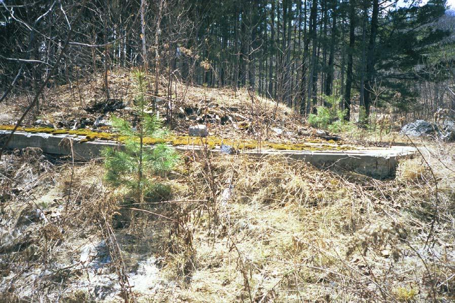
10 FEDERAL ASTM SUPPLEMENTAL CONSENT Superfund (CERCLA) Consent Decrees ROD Records Of Decision Delisted NPL National Priority List Deletions FINDS Facility Index System/Facility Identification Initiative Program Summary Report HMIRS Hazardous Materials Information Reporting System MLTS Material Licensing Tracking System MINES Mines Master Index File NPL Liens Federal Superfund Liens PADS PCB Activity Database System INDIAN RESERV Indian Reservations UMTRA Uranium Mill Tailings Sites ODI Open Dump Inventory FUDS Formerly Used Defense Sites DOD Department of Defense Sites RAATS RCRA Administrative Action Tracking System TRIS Toxic Chemical Release Inventory System TSCA Toxic Substances Control Act SSTS Section 7 Tracking Systems FTTS INSP FIFRA/ TSCA Tracking System - FIFRA (Federal Insecticide, Fungicide, & Rodenticide Act)/TSCA (Toxic Substances Control Act) STATE OR LOCAL ASTM SUPPLEMENTAL AST Registered Aboveground Petroleum Storage Tank Database LAST Listing of All Sites NH Spills Listing of All Sites EDR PROPRIETARY HISTORICAL DATABASES Coal Gas Former Manufactured Gas (Coal Gas) Sites BROWNFIELDS DATABASES US BROWNFIELDS Inst Control VCP BROWNFIELDS A Listing of Brownfields Sites Activity and Use Restrictions Voluntary Cleanup Program Sites Brownfields Sites D. CURRENT DESCRIPTION FST visited the site on April 12, Appendix C contains photographs of the site taken that day. The site was clear of snow, although ice covered most of the lake. The access road into the site leaves Birch Grove Road, crosses the former railroad right of way and enters the property. The site is wooded. Much of the lakeshore is rocky. A small beach was observed at the northern side of the property. Sunapee Lake Wild Goose Property Page 8 Fay, Spofford & Thorndike
11 The former railroad bed parallels a portion of Birch Grove Road. No structures related to railroad operations were noted. It appears that all ties and rails had been removed. The right of way north of the access road is overgrown. No visible signs that the railroad bed is used for vehicle or foot traffic. The railroad right of way is approximately 4 feet lower than Birch Grove Road. Minor trash was noted along the bank between them. The trash included two rusted out drums, a rusted out water heater and an automobile tire (Appendix C). The property has no buildings. There are rubble piles of concrete blocks, wood and shingles that seem to mark the locations of former cottages. There is a concrete slab foundation at the location of the property s former main building (Appendix C). Rotted stairs lead down to remnants of a dock on the east side of the property. A few brick fireplaces remain. Particular attention was paid to look for indications that the property had been accessed improperly for disposal of wastes. No solid waste was observed other than the rubble discussed above. No stressed vegetation, staining of soil or odors was noted that might suggest improper disposal of liquids. E. CONCLUSIONS The Site was last used for summer rental cottages. This continued the Site s long history of recreational use. A former railroad bed runs along the western side of the Site. At one time, the adjacent property to the south had a railroad station and steamboat terminal for transportation of vacationers. No historical information reviewed indicated that use extended onto the subject property. There has been no passenger service since 1955 and no freight service since 1964 along that line. No reviewed documents indicated any commercial or industrial use of the Site. No reviewed document indicated any former fuel storage on the Site other than the three (3) residential fuel oil tanks documented in the Provan & Lorber assessment. No fuel oil heating equipment, no tanks and no oil staining were observed on the property. While it is reasonable to assume that maintenance related to prior recreational activities used oils, paint and gasoline, no indication of significant environmental damage from them was noted. No reviewed and no visual evidence indicated any past improper disposal of either solid waste or hazardous waste. Rubble visible on the property appears to be from former buildings. No State or federal environmental database reviewed for information on hazardous waste, use or storage of hazardous materials or known contamination listed this property. Sunapee Lake Wild Goose Property Page 9 Fay, Spofford & Thorndike
12 State of New Hampshire Wild Goose Site Scanned image of 1998 Newport, NH Quadrangle USGS 7.5 x 15 minute series, not to scale Figure 1 Wild Goose Site Location Map
13 APPENDIX A HISTORIC MAPS, USGS TOPOS, PLAN
, Not")
14 1880 Map of Lake Sunapee and Vicinity Reached by Boston and Maine Railroad, obtained from New Hampshire Historical Society s Tuck Library (Concord, NH), Not to Scale
15 1892 Hurd Atlas obtained from New Hampshire Historical Society s Tuck Library (Concord, NH), Not to Scale

16 1907 Sunapee, NH Quadrangle USGS 15 series topographic map, obtained from the UNH DIMOND LIBRARY Government Documents Dept. - ( Not to Scale
, Not to")
17 1911 Hancox s Double Indexed Map and Guide to Lake Sunapee, obtained from New Hampshire Historical Society s Tuck Library (Concord, NH), Not to Scale
18 1914 (June) Railroad Val map (Part 1 of 2), obtained from New Hampshire Department of Transportation, Railroad Bureau (Concord, NH), Not to Scale
, Not to")
19 1914 (June) Railroad Val map (Part 2 of 2), obtained from New Hampshire Department of Transportation, Railroad Bureau (Concord, NH), Not to Scale
, Not to")
20 1915 Hancox s Double Indexed Map and Guide to Lake Sunapee, obtained from New Hampshire Historical Society s Tuck Library (Concord, NH), Not to Scale
, Not to")
21 1950 Plans of proposed central road improvements (State Route 103) in Towns of Sunapee and Newbury obtained from New Hampshire Department of Transportation Records Bureau (Concord, NH), Not to Scale

22 1955 Sunapee, NH Quadrangle USGS 15 series topographic map, obtained from the UNH DIMOND LIBRARY Government Documents Dept. - ( Not to Scale

23 In 1955 Plan of Wild Goose Lodges recorded 10/24/1956 at the Merrimack County Register of Deeds, Not to Scale

24 1984 Newport, NH Quadrangle USGS 7.5 x 15 minute series topographic map, obtained from EDR Historical Topographic Map Report, Not to Scale

25 1998 Newport, NH Quadrangle USGS 7.5 x 15 minute series topographic map, obtained from EDR Historical Topographic Map Report, Not to Scale
26 Compilation of several ground surveys performed Circa 2000 for the New Hampshire Fish and Game Department, Not to Scale
27
28 APPENDIX B EDR REPORT
29 APPENDIX C PHOTOGRAPHS

30 Proposed NHF&G Boating and Fishing Access Site Remnants of Concrete Platform, Previous Location of B&M Railroad Station and Steamboat Landing Aerial photograph taken in 2002 for the New Hampshire Fish and Game Department

31 Aerial photograph taken in 2002 for the New Hampshire Fish and Game Department Proposed NHF&G Boating and Fishing Access Site

32 Concrete rubble Foundation slab


33 Overgrown rubble Rocky site terrain


34 Building rubble Building rubble


35 Concrete slab Cottages on neighboring property


36 Former railroad bed Rusted drum
37 APPENDIX D EXCERPTS SCANNED FROM 1990 LEVEL I SITE ASSESSMENT (PROVAN & LORBER, INC.)
38
39
40
41
42
43

44

45

46
FACT SHEET HUNTERS POINT SHIPYARD Parcel E-2 PCB Hot Spot Time-Critical Removal Action: 2010
 FACT SHEET HUNTERS POINT SHIPYARD Parcel E-2 PCB Hot Spot Time-Critical Removal Action: 2010 Shoreline Hot Spot Area Central Portion - View North October 2009 This fact sheet provides information about
PCBS DELINEATION WORK PLAN
 PCBS DELINEATION WORK PLAN BLUE ISLAND NORTHEAST MIXED-USE COMMERCIAL PARK (FORMER BLUE ISLAND LANDFILL) BLUE ISLAND, COOK COUNTY, ILLINOIS PREPARED FOR: CITY OF BLUE ISLAND 13051 SOUTH GREENWOOD AVENUE
Section 61 Recreational Vehicle Park / Campground (Bylaw No. 2012/10)
") Part 7 General Regulations Section 61 Recreational Vehicle Park / Campground (Bylaw No. 2012/10) 61.1 A comprehensive site plan shall be provided to the satisfaction of the Development Authority that shows
Part 7 General Regulations Section 61 Recreational Vehicle Park / Campground (Bylaw No. 2012/10) 61.1 A comprehensive site plan shall be provided to the satisfaction of the Development Authority that shows
List of Environmental Reports and Documents Regarding Hazardous Materials. August 10, 2017
 List of Environmental Reports and Documents Regarding Hazardous Materials August 10, 2017 Pier 70 1999 Annual Ground Water Monitoring Report for Piers 70 and 94, Tetra Tech, Inc., February 2000. 1999 Annual
Restoration and Redevelopment of the Former Durango Paper Mill Site
 Restoration and Redevelopment of the Former Durango Paper Mill Site 1 Durango Site Overview and History Durango-Georgia Bankruptcy LandMar Group Overview The Durango Challenge Environmental Challenges
Lake Erie Commerce Center Traffic Analysis
 LOCATION: East of NYS Route 5 at Bayview Road Town of Hamburg Erie County, New York PREPARED BY: Wendel Companies 140 John James Audubon Parkway Suite 200 Amherst, New York 14228 January 2012 i ii Table
Cascade River State Park Management Plan Amendment
 This document is made available electronically by the Minnesota Legislative Reference Library as part of an ongoing digital archiving project. http://www.leg.state.mn.us/lrl/lrl.asp Cascade River State
Sales Associate Course
 Sales Associate Course Chapter Nineteen Planning, Zoning and Environmental Hazards Copyright Gold Coast Schools 1 Government Planning Planning in U.S. dates back to the colonial period Government did not
At the time, the portion of the line through Eagle County remains wholly under the ownership of Union Pacific Railroad (UP).
.") Chapter 5 The Railroad Corridor as a Trail Corridor The intent of this chapter is to identify how the rail corridor, if available for lease or purchase in all or part, could be incorporated into the core
Chapter 5 The Railroad Corridor as a Trail Corridor The intent of this chapter is to identify how the rail corridor, if available for lease or purchase in all or part, could be incorporated into the core
Georgetown-Lewes Rail/Trail Study. Rail/Trail Study: Cool Spring to Cape Henlopen State Park New Road Extension (House Resolution No.
 Georgetown-Lewes Rail/Trail Study Rail/Trail Study: Cool Spring to Cape Henlopen State Park New Road Extension (House Resolution No. 47) August 22, 2011 Presentation Outline Background Benefits Statewide
SITE SUMMARY REPORT Troy Landfill NONCD Montgomery County
 SITE SUMMARY REPORT Troy Landfill NONCD 0000436 Montgomery County Senate Bill 1492 State of North Carolina State Contract N06009S Schnabel Project No. 06210002.23 March 8, 2010 Prepared for: North Carolina
CRS Report for Congress
 Order Code RL32533 CRS Report for Congress Received through the CRS Web Vieques and Culebra Islands: An Analysis of Cleanup Status and Costs Updated July 7, 2005 David Bearden Analyst in Environmental
4. Safety Concerns Potential Short and Medium-Term Improvements
 NH Route 104 Access Management Study Page 19 4. Safety Concerns Potential Short and Medium-Term Improvements Potential safety improvement strategies are listed by priority based on field observations by
Mankato s Transportation Heritage
 Mankato s Transportation Heritage City of Mankato Mankato Heritage Preservation Commission May 11, 2017 1. Union Depot, 112 S. Riverfront Drive, c. 1896. The railroads were Mankato s dominant transportation
SUTTER COUNTY. General Plan Update Technical Background Report
 SUTTER COUNTY General Plan Update Technical Background Report February 2008 SUTTER COUNTY GENERAL PLAN UPDATE TECHNICAL BACKGROUND REPORT PREPARED FOR: SUTTER COUNTY PREPARED BY: PBS&J IN PARTNERSHIP
Airport Planning Area
 PLANNING AREA POLICIES l AIRPORT Airport Planning Area LOCATION AND CONTEXT The Airport Planning Area ( Airport area ) is a key part of Boise s economy and transportation network; it features a multi-purpose
Section II. Planning & Public Process Planning for the Baker/Carver Regional Trail began in 2010 as a City of Minnetrista initiative.
 Section II Planning & Public Process Planning for the began in 2010 as a City of initiative. city staff began discussions with the Park District on the possibility of a north/south regional trail connection
Table of Contents. Location... 1 Cultural Heritage Value... 3 Site History... 4 Physical Description... 6 Conclusion... 7 Sources...
 Executive Summary The Outdoor Firing Range, located west of the Small Arms Building at 1300 Lakeshore Road East, merits designation under the Ontario Heritage Act for its historical, architectural and
Seasonal Camping Agreement Beavermead Family Campground 2018
 Seasonal Camping Agreement Beavermead Family Campground 2018 No person shall occupy or make use of a seasonal campsite until all camping fees have been paid in full, and the seasonal camping permit has
35 Bee Tree Park Planning Zone 3
 35 Bee Tree Park Planning Zone 3 2701 Finestown Road Visit Date: August 2016 St. Louis County Parks Master Plan Page 1 35 Bee Tree Park 2701 Finestown Road St. Louis County Parks Master Plan Planning Zone
Table 1: Black Eagle Communication Site. Latitude 1 Longitude 1 Elev 2 Address T/R/S 3 APN 4 USGS Quadrangle
 County of Riverside Public Safety Enterprise Communication Project Appendix A: Candidate Site Descriptions Overview The site is located on a previously graded and benched plateau within the Black Eagle
NEWBORO AND PORTLAND HARBOUR REDVELOPMENT PLANS
 INTRODUCTION The Municipal docks in both Newboro and Portland were transferred to the Township of Rideau Lakes by Parks Canada in 2002. Little has been done to improve the docks physical condition or role
DRAFT. Dorabelle Campground Rehabilitation
 DRAFT Dorabelle Campground Rehabilitation September 2012 1.1 REGIONAL SETTING AND PROJECT LOCATION The Dorabelle Campground is located on the western shore of Shaver Lake in Fresno County, California (Section
Southwind Marina Sinton Drive Pensacola, Florida Unique Opportunity to Acquire a 90 Slip Marina With Excellent Investment Potential
 Urban Realty Southeast is pleased to present Southwind Marina 10121 Sinton Drive Pensacola, Florida 32507 Unique Opportunity to Acquire a 90 Slip Marina With Excellent Investment Potential Closest marina
Table 1: Iron Mountain Communication Site. Latitude 1 Longitude 1 Elev 2 Address T/R/S 3 APN 4 USGS Quadrangle
 County of Riverside Public Safety Enterprise Communication Project Appendix A: Candidate Site Descriptions Overview The site is located in San Bernardino County near several communication towers in the
AGENDA ITEM 5 D WAKULLA ENVIRONMENTAL INSTITUTE (WEI) TRAIL FEASIBILITY STUDY
 TRAIL FEASIBILITY STUDY") March 19, 2018 AGENDA ITEM 5 D WAKULLA ENVIRONMENTAL INSTITUTE (WEI) TRAIL FEASIBILITY STUDY TYPE OF ITEM: Action STATEMENT OF ISSUE The Wakulla Environmental Institute (WEI) Trail is one of several trails
March 19, 2018 AGENDA ITEM 5 D WAKULLA ENVIRONMENTAL INSTITUTE (WEI) TRAIL FEASIBILITY STUDY TYPE OF ITEM: Action STATEMENT OF ISSUE The Wakulla Environmental Institute (WEI) Trail is one of several trails
Tour of the Rancho Mission Viejo Riding Park at San Juan Capistrano Eastern Open Space JULY 2016
 Tour of the Rancho Mission Viejo Riding Park at San Juan Capistrano Eastern Open Space JULY 2016 Text of Measure Y Health & Safety Issues One of four horse washing stations (left) next to Federally & State
A number of goals were identified during the initial work on this Big Lake Transportation Plan.
 C. Transportation General Background Information Big Lake s transportation system includes all the roads, paths and facilities that allow the movement of private vehicles, trains and planes, as well as
ORDINANCE NO. JACKSON TOWNSHIP, CAMBRIA COUNTY
 ORDINANCE NO. JACKSON TOWNSHIP, CAMBRIA COUNTY AN ORDINANCE OF THE TOWNSHIP OF JACKSON AMENDING SECTIONS OF THE JACKSON TOWNSHIP ZONING ORDINANCE AS FOLLOWS: PROVIDING NEW DEFINITIONS OF CAMPGROUNDS, CAMPSITE,
Hotels and Inns. Green Purchasing Network (GPN)
") GPN-GL5 Using Guidelines for Hotels and Inns Green Purchasing Network (GPN). Scope These guidelines cover important environmental issues that shall be considered when selecting and using accommodations
GPN-GL5 Using Guidelines for Hotels and Inns Green Purchasing Network (GPN). Scope These guidelines cover important environmental issues that shall be considered when selecting and using accommodations
I I I I LINDEN TO WOOD FORD SURVEY ITEMS OF HISTORICAL SIGNIFICANCE I I I I I I I I I I I I I
 LNDEN TO WOOD FORD SURVEY TEMS OF HSTORCAL SGNFCANCE ------------------------------------------------------------------------------ --- - CONTENTS OF THE REPORT 1.0 ntroduction to the Report 1.1 Parameters
FILE: /PERM EFFECTIVE DATE: May 16, 2014 AMENDMENT:
 APPROVED AMENDMENTS: Effective Date Briefing Note /Approval Summary of Changes: FILE: 11000-00/PERM EFFECTIVE DATE: May 16, 2014 AMENDMENT: Table of Contents 1. POLICY APPLICATION... 1 2. PRINCIPLES AND
SCHEDULE B CLASSIFICATION OF USES OF LAND AND BUILDINGS
 Torbay Municipal Plan 2015-2025, Schedule B Page 1 SCHEDULE B CLASSIFICATION OF OF LAND AND BUILDINGS A. ASSEMBLY 1. Uses for the production and viewing of the performing arts. (a) Theatre Motion Picture
THE GHOST ROSE RANCH. Randy J. Wood Qualifying Broker Cell:
 Wild West Properties, LLC 7020 Santa Marisa, NE Albuquerque, NM 87113 505-836-4558 http://www.wildwestproperties.com/ Randy J. Wood Qualifying Broker Cell: 505-980-8019 E-mail: rjwood5@comcast.net THE
Final Report. Community Recreation Inventory Burwash Landing. Capital Management Engineering Limited. April 2016 Project Number
 Capital Management Engineering Limited EMPOWERING OUR CLIENTS WITH KNOWLEDGE 5531 Cornwallis Street, Halifax, NS, Canada B3K 1B3 Phone: 902 429 4412 Fax: 902 423 4945 Final Report Burwash Landing April
ANNUAL REPORT DALLAS LOVE FIELD AIRPORT. March 14, 2006
 ANNUAL REPORT DALLAS LOVE FIELD AIRPORT March 14, 2006 I. INTRODUCTION On August 20, 2001, the Texas Commission on Environmental Quality (TCEQ) signed and published the final version of the Texas Pollutant
BARODA TOWNSHIP OPEN BURNING ORDINANCE. Ordinance No. 35
 BARODA TOWNSHIP OPEN BURNING ORDINANCE Ordinance No. 35 TABLE OF CONTENTS Section 1: Authority. 2 Section 2: Purpose...2 Section 3: Applicability......2 Section 4: Definitions...2 Section 5: Open burning
Property Summary HWY 7 Warsaw, Missouri 65355
 Property Summary Offer at $695,000.00 Contact: Chuck Gray, Re/Max Truman Lake, (660) 525-0393 Grand River Resort 11919 HWY 7 Warsaw, Missouri 65355 http://www.grandriverresort.net 18 full hook up RV sites,
110 N Coeur d'alene Ave, Harrison, ID 83833
 Lakeview Lodge 110 N Coeur d'alene Ave, Harrison, ID 83833 Listing ID: 30045830 Status: Active Property Type: Hospitality For Sale Hospitality Type: Motel Size: 8,000 SF Sale Price: $1,485,000 Unit Price:
Big Cook s Pond Cottage Management Plan. Environmental Assessment Registration
 GOVERNMENT OF NEWFOUNDLAND AND LABRADOR Department of Environment and Conservation Lands Branch, Land Management Division Big Cook s Pond Cottage Management Plan Environmental Assessment Registration 1.
Aviation, Rail, & Trucking 6-1
 6-1 This chapter describes the services, facilities, and condition of air, rail, and trucking as components of the transportation system. These three intermodal areas have an impact on the factors to be
4.19 Parks, Recreation, and Conservation Lands
 interchange would have on the Reed Paige Clark Homestead located on the north side of Stonehenge Road. Alternative D would also affect Palmer Homestead, E.F. Adams House, and Knapp Brothers Shoe Manufacturing
The rezoning application is recommended for consideration of approval.
 Date: November 26, 2012 To: From: Chairperson and Members Planning and Housing Committee Ken O Brien, MCIP Manager of Planning & Information Cliff Johnston, MCIP Director of Planning Re: Department of
United States Department of the Interior National Park Service. Boundary Expansion Listed in National Register January 11, 2017
 NPS Form 10900-a (Rev. 8/2002) OMB No. 10240018 United States Department of the Interior National Park Service Boundary Expansion Listed in National Register January 11, 2017 National Register of Historic
BELFAST MUNICIPAL AIRPORT OVERVIEW
 BELFAST MUNICIPAL AIRPORT OVERVIEW LOCATION AND HISTORY Belfast Municipal Airport (Federal Aviation Administration (FAA) airport code BST, International Civil Aviation Organization airport code KBST, FAA
M E M O R A N D U M. Status of the Environmental Cleanup of the Shipyard
 ECONOMIC AND WORKFORCE DEVELOPMENT MICHAEL COHEN, DIRECTOR CITY AND COUNTY OF SAN FRANCISCO GAVIN NEWSOM, MAYOR M E M O R A N D U M TO: Members of the Health Commission FROM: Michael Cohen CC: Mitch Katz,
Cruise Industry Perspective on OWS and Waste Management
 Cruise Industry Perspective on OWS and Waste Management MAX1 OWS Studies Conference Wilmington, NC, 24 June 2015 James R. Van Langen, P.E. Environmental, Safety, Quality & Sustainability Consultant Cruise
Page 68-1 rev (7) standards and requirements for aeronautical services and related activities at the airport.
 standards and requirements for aeronautical services and related activities at the airport.") 68.01 68.11(7) CHAPTER 68 AIRPORT MINIMUM STANDARDS ORDINANCE 68.01 Title. 68.02 Purpose. 68.03 Definitions. 68.04 Administration and Policy Oversight. [68.05-68.10 reserved.] 68.11 Evidence of Qualifications.
68.01 68.11(7) CHAPTER 68 AIRPORT MINIMUM STANDARDS ORDINANCE 68.01 Title. 68.02 Purpose. 68.03 Definitions. 68.04 Administration and Policy Oversight. [68.05-68.10 reserved.] 68.11 Evidence of Qualifications.
Preliminary Site Evaluation
 Preliminary Site Evaluation 100 Acre Site, US 72 Piperton, Tennessee Power Distributor: Chickasaw Electric Cooperative August 2010 SITE DATA SHEET PIPERTON US 72 SITE (100 ACRES): LOCATION & GENERAL DESCRIPTION
C. APPROACH FOR IDENTIFYING THE BEST ROUTES FOR THE NEEDED TRANSMISSION SYSTEM IMPROVEMENTS
 C. APPROACH FOR IDENTIFYING THE BEST ROUTES FOR THE NEEDED TRANSMISSION SYSTEM IMPROVEMENTS CL&P s approach for identifying the best routes for the needed transmission system improvements included a determination
Introducing the Lower Connecticut River Valley Trail
 Introducing the Lower Connecticut River Valley Trail 1 2 Purpose of Today s Presentation To introduce you to an important opportunity to protect some of the most valuable property in the Lower CT River
1. Overview of Aberdeen Township and Its Waterfront
 Aberdeen 1. Overview of Aberdeen Township and Its Waterfront 1.1 Geographic Overview Aberdeen Township is a suburban township with a land area of 5.45 square miles, with about 2 miles of shoreline along
FOR SALE CASTLEWIGG CARAVAN PARK WHITHORN, NEWTON STEWART, DUMFRIES & GALLOWAY, DG8 8DL
 FOR SALE CASTLEWIGG CARAVAN PARK WHITHORN, NEWTON STEWART, DUMFRIES & GALLOWAY, DG8 8DL SUMMARY Established holiday caravan park extending to circa 5.3 acres (2.2 ha). Developed with 22 touring caravan
THAT the Board approve the final proposed concept plan for the Jericho Marginal Wharf site as shown in Figure C-4 of Appendix C.
 Date: January 17, 2012 TO: Board Members Vancouver Park Board FROM: General Manager Parks and Recreation SUBJECT: Jericho Marginal Wharf Phase 2 Concept Plan RECOMMENDATION THAT the Board approve the final
Abandoned Mine Sites Policy
 SUBJECT: Abandoned Mine Sites Policy Policy Number: MRE 006 2004 C. R. File Number: 565 00 0002 Effective Date: September 1, 2004 To Be Reviewed: September 1, 2008 Approval: Original signed by W. David
CORNWALL WATERFRONT PLAN 2007
 CANAL LANDS CANAL LANDS Page 58 Introduction This chapter details areas of possible development or redevelopment, and lands to be protected from any form of development in the Canal Lands area. As outlined
September Property Clearing. Resort Update
 September 2012 3820 Hot Springs Road P.O. Box 415 MCPOA BOARD: Dennis Nau, President P.O. Box 738 208-347-4190 or 760-727-4519 dcnau@earthlink.net Pat Bloom, Vice President P.O. Box 760 208-347-2481 patbbsteel@yahoo.com
Iron Range Brownfield Assessment Coalition Site Eligibility and Property Ownership Determination Community: City of Eveleth
 Iron Range Brownfield Assessment Coalition Site Eligibility and Property Ownership Determination Community: City of Eveleth Site: City Snow Dump Date: November 20, 2012 A. Basic Site Information: Name:
3. COLTA / HUGA CONNECTIONS - PRELIMINARY
 9 3. COLTA / HUGA CONNECTIONS - PRELIMINARY 3.1 COLTA The Chain of Lakes Trail Association (COLTA) trail, formerly identified as the Chester Spur Line, was completed and opened for use in June 2011. The
CITY PLANNING COMMISSION AGENDA ITEM NOS: 5.A, 5.B STAFF: MICHAEL SCHULTZ
 CPC Agenda Page 83 CITY PLANNING COMMISSION AGENDA ITEM NOS: 5.A, 5.B STAFF: MICHAEL SCHULTZ FILE NO(S): CPC DP 03-00259-A5MN11 QUASI-JUDICIAL AR NV 11-00538 QUASI-JUDICIAL PROJECT: BROADMOOR TEMPORARY
PURPOSE AND NEED (CONCURRENCE POINT 1) NEW CANADA ROAD PROJECT FROM STATE ROUTE 1 (U.S. HIGHWAY 70) TO U.S. INTERSTATE 40
 NEW CANADA ROAD PROJECT FROM STATE ROUTE 1 (U.S. HIGHWAY 70) TO U.S. INTERSTATE 40") PURPOSE AND NEED (CONCURRENCE POINT 1) NEW CANADA ROAD PROJECT FROM STATE ROUTE 1 (U.S. HIGHWAY 70) TO U.S. INTERSTATE 40 Project Description The primary purpose of this project is to improve the major
PURPOSE AND NEED (CONCURRENCE POINT 1) NEW CANADA ROAD PROJECT FROM STATE ROUTE 1 (U.S. HIGHWAY 70) TO U.S. INTERSTATE 40 Project Description The primary purpose of this project is to improve the major
Building Permit Application
 Building Permit Application Co-Owner Name Lot # Address City State Zip Phone (home) (cell) Contractor (if applicable) The above named co-owner hereby makes application to Cedar Shores Campground Condominium
THE RESERVE III AT SUGAR MOUNTAIN, NORTH CAROLINA
 THE RESERVE III AT SUGAR MOUNTAIN, NORTH CAROLINA Information Memorandum AUGUST 2015 THE RESERVE III Contents I. THE PROPERTY... 3 OVERVIEW... 3 READY TO BUILD... 4 INEXPENSIVE CONSTRUCTION... 5 ADDITIONAL
Planning Board Meeting Minutes.Approved. Aug 6, 2018
 APPROVED MEETING MINUTES TOWN OF WARNER PLANNING BOARD August 6, 2018 7:00 PM WARNER TOWN HALL - LOWER MEETING ROOM 5 East Main Street, Warner, NH 03278 OPEN MEETING ROLL CALL Present: Ben Frost (Chair),
Empire Township Application for Land Use Permit
 Empire Township Application for Land Use Permit Indigo Bluffs RV Park & Resort Park Model Addition Submitted as a Camp Ground a Special Land Use in the Agricultural Conservation District April 2014 4-21-2014
LONG TERM (OPERATION) IMPACTS AND POTENTIAL MITIGATION
 IMPACTS AND POTENTIAL MITIGATION") 3.6 This chapter provides a project-level analysis of potential impacts to recreation sites in the study area including parks, natural areas, open spaces, trails, and playfields, as well as amenities such
3.6 This chapter provides a project-level analysis of potential impacts to recreation sites in the study area including parks, natural areas, open spaces, trails, and playfields, as well as amenities such
AN ARCHAEOLOGICAL ASSESSMENT OF BOERNE CITY PARK, KENDALL COUNTY, TEXAS. Thomas C. Kelly and Thomas R. Hester
 AN ARCHAEOLOGICAL ASSESSMENT OF BOERNE CITY PARK, KENDALL COUNTY, TEXAS Thomas C. Kelly and Thomas R. Hester Center for Archaeological Research The University of Texas at San Antonio Archaeological Survey
Steel Mill Products 1999
 Steel Mill Products 1999 Issued December 2002 MA331B(99)-1(RV) (Formerly Series No. MA33B) Information about the scope of the survey, methodology, explanation of terms and historical notes for this survey
Santa Clara South Hills Recreation Park Project Development and Management Plan
 Santa Clara South Hills Recreation Park Project Application for Land for Recreation or Public Purposes, City of Santa Clara, Utah Prepared for: Bureau of Land Management, St. George Field Office 345 East
COMMUNITY RELATIONS PLAN BROWNFIELDS CLEANUP AND REDEVELOPMENT OF MASKER S THEATER & THOMPSON S WHARF PROPERTY 45 FRONT STREET BELFAST, MAINE REV.
 COMMUNITY RELATIONS PLAN BROWNFIELDS CLEANUP AND REDEVELOPMENT OF MASKER S THEATER & THOMPSON S WHARF PROPERTY 45 FRONT STREET BELFAST, MAINE REV. 02 Prepared for: City of Belfast, Maine 131 Church Street
MP : Headwaters of the Fraser River
 MP 236 237: Headwaters of the Fraser River The mile between these two mileage posts is often just referred to as the bottom switchback or the curve at the bottom of Berthoud Pass. For many locals this
Porter Fk. #1. All unauthorized items removed as per FS & Rec Res guidelines. Footbridge may be needed for wheel chair access and for safety
 APPENDIX D Lot Specific Permit Compliance & Forest Plan (FP) Requirements Porter Fork Recreation Residence Tract (Items noted were documented in compliance letter, 8/12/2005, sent to all Rec. Residence
RAILROAD PARK AGREEMENT
 RAILROAD PARK AGREEMENT THIS AGREEMENT made and entered into this day of, 20, by and between the City of MEDFORD, an Oregon municipal corporation hereinafter know as "City", the SOUTHERN OREGON CHAPTER
MINNESOTA ARCHITECTURE - HISTORY INVENTORY FORM Property Location
 MINNESOTA ARCHITECTURE - HISTORY INVENTORY FORM ------ - Property Location -- ---- Property Name: Washington Park Address: 215 N 4th Street County: Blue Earth City/Twp: Mankato PIN: R01.09.07.461.001 Legal
San Juan Resource Area Recreation Impact Inventory/Monitoring
 San Juan Resource Area Recreation Impact Inventory/Monitoring Indian Creek Climbing Area Overview & Summary of Findings 2007 Pam Foti, Professor Aaron Divine, Lecturer Janet Lynn, Program Coordinator Northern
APPENDIX H. Contaminated Overview Study
 APPENDIX H Contaminated Overview Study WATERMAIN & SEWER REPLACEMENT / RELINING, DOWNTOWN BRAMPTON, ON CONTAMINATION OVERVIEW STUDY CH2M Project n o : 161-15936-00 Date: July 2017 WSP Canada Inc. 51 Constellation
Society Member to Supervise the Building of James Monroe s Birthplace House Charles Belfield, a councilor of the War of 1812 Society in the
 Society Member to Supervise the Building of James Monroe s Birthplace House Charles Belfield, a councilor of the War of 1812 Society in the Commonwealth of Virginia has been designated as the supervisor
CISCO GROVE CAMPGROUND & RV PARK. Hwy 80 at Cisco Grove, Soda Springs, CA 4X6 PICTURE
 CISCO GROVE CAMPGROUND & RV PARK Hwy 80 at Cisco Grove, Soda Springs, CA RV Resort For Sale 4X6 PICTURE $3,700,000 Sales Price Beautiful Lake Tahoe Mountains 5,800 Feet Elevation on the Yuba River 425
BUNKHOUSE ASSESSMENT REPORT
 FEBRUARY 2014 EXECUTIVE SUMMARY As a response to the need to provide temporary shelters for the victims of Typhoon Haiyan, the Philippine government through the DSWD and the DPWH decided to build bunkhouses.
Ormiston House HAWICK ROXBURGHSHIRE
 Ormiston House HAWICK ROXBURGHSHIRE Ormiston House HAWICK ROXBURGHSHIRE Secluded country house in beautiful countryside Hall 4 reception rooms 8 bedrooms 5 bathrooms (2 ensuite) Kitchen/breakfast room
Lemont Fire Protection District Open Burning Regulations July 6, 2012
 Lemont Fire Protection District Open Burning Regulations July 6, 2012 The following information outlines the laws pertaining to open burning throughout all areas of the Fire District CITY OF DARIEN: Open
A detached period home with loch views. rhu house by tarbert, argyll, pa29 6yf
 A detached period home with loch views rhu house by tarbert, argyll, pa29 6yf A detached period home with loch views rhu house by tarbert, argyll, pa29 6yf Porch sitting room drawing room dining room
TRAVEL BAROMETER, Fall 2015
 TRAVEL BAROMETER, Fall 2015 Overall Performance The indicators used in the "travel barometer" for New Hampshire show that Fall 2015 was a positive period for the State's travel sector when compared with
Energy from Waste and Recycling Facility Trident Park, Cardiff. Planning History. January 2010 SLR Ref: B
 Energy from Waste and Recycling Facility Trident Park, Cardiff Planning History January 2010 Ref: 402-0036-0306B Viridor Ltd. i 402/0036/00306B CONTENTS 1.0 INTRODUCTION... 1 2.0 GENERAL HISTORY... 3
Ribbon Cliff - Ribbon Mesa text and photos by Charlie Hickenbottom
 Ribbon Cliff - Ribbon Mesa text and photos by Charlie Hickenbottom Looking for something a little different than Sage Hills or Saddlerock? Perhaps something a little wilder, a little less traveled? Look
High Winder House & Holiday Cottages Tirril, Penrith, Cumbria, CA10 2LS Lake District National Park
 High Winder House & Holiday Cottages Tirril, Penrith, Cumbria, CA10 2LS Lake District National Park High Winder House, Tirril Page 4 of 16 High Winder House & Holiday Cottages An attractive 17 th Century
Appendix C. Cultural Heritage Properties
 Appendix C Cultural Heritage Properties Existing Conditions Report Page 1 Don River Mouth Naturalization and Port Lands Flood Protection Project Appendix C: Inventory of Cultural Heritage Properties in
CHAPTER 4 -- THE LAND USE PLAN: DESCRIPTIONS AND POLICIES FOR THIRTEEN PLANNING AREAS
 CHAPTER 4 -- THE LAND USE PLAN: DESCRIPTIONS AND POLICIES FOR THIRTEEN PLANNING AREAS SOUTH COAST CAC PLANNING AREA 4.10 NAVARRO RIVER TO MALLO PASS CREEK PLANNING AREA (Includes Greenwood/Elk) This planning
1803 West Hwy 160 Monte Vista, CO (719) TTY (719)
 TTY (719)") USDA Forest Service Rio Grande National Forest http://www.fs.fed.us/r2/riogrande 1803 West Hwy 160 Monte Vista, CO 81144 (719)852-5941 TTY (719)852-6271 USDI Bureau of Land Management San Luis Valley Center
USDA Forest Service Rio Grande National Forest http://www.fs.fed.us/r2/riogrande 1803 West Hwy 160 Monte Vista, CO 81144 (719)852-5941 TTY (719)852-6271 USDI Bureau of Land Management San Luis Valley Center
CITY OF PALMDALE. REPORT to the Mayor and Members of the City Council from the City Manager
 CITY OF PALMDALE REPORT to the Mayor and Members of the City Council from the City Manager DATE: June 4, 2014 SUBJECT: Specific Plan Amendment 14-01; Amending the Use Designation of 23.97 Acres within
EU ECOLABEL USER MANUAL TOURIST ACCOMMODATION Commission Decision for the award of the EU Ecolabel for tourist accommodation (2017/175/EC)
") Check-List This checklist (in blue table) summarises the documentation to be provided for each mandatory criterion. The documentation described below has to be submitted to the Competent Body. Applicant
Check-List This checklist (in blue table) summarises the documentation to be provided for each mandatory criterion. The documentation described below has to be submitted to the Competent Body. Applicant
482 :fi6 D34 --' v.i9 ~
 '- SB 482 :fi6 D34 --' v.i9 ~ This document is made available electronically by the Minnesota Legislative Reference Library as part of an ongoing digital archiving project. http://www.leg.state.mn.us/lrl/lrl.asp
SWINGING OVER SCHUYLKILL THE HISTORY OF THE PW&B AND BRIDGE NO. 31
 THE SWINGING OVER SCHUYLKILL THE HISTORY OF THE PW&B AND BRIDGE NO. 31 The Philadelphia, Wilmington & Baltimore Railroad Company (PW&B) was formed in 1836. In 1838, the railroad was enlarged by the joining
SOUTH INTERCHANGE AREA
 Santaquin City General Plan 1 Location and Characteristics The South Interchange Area of Santaquin is located west of Interstate 15 and south of 500 South (Figure 1). It includes properties already annexed
Date: 11 th January, From: Plaistow & Ifold Parish Neighbourhood Plan - Steering Group. Plaistow & Ifold Parish Council
 Date: 11 th January, 2017 From: Plaistow & Ifold Parish Neighbourhood Plan - Steering Group To: Plaistow & Ifold Parish Council Re: Neighbourhood Plan Report to Parish Council Meeting 17 Jan 2017 The Steering
WALTON MARSH RAILROAD TIES
 WALTON MARSH RAILROAD TIES A PROJECT SURVEY BY COLIN FRYE Supervisor: Dr. Mark Holley The Walton Marsh Railroad Tie project involved the survey and study of six railroad ties discovered in and on the shoreline
Creating a User-Driven Long-Distance OHV Trail Through Partnering
 Joseph Raffaele Outdoor Recreation Planner U.S. Bureau of Land Management Yuma, Arizona Creating a User-Driven Long-Distance OHV Trail Through Partnering BLM is a multiple-use land management agency within
Keeping Fun Safe. A public discussion paper on a new Amusement Ride Regulation for Manitoba
 Keeping Fun Safe A public discussion paper on a new Amusement Ride Regulation for Manitoba October 2016 This information is available in alternate formats upon request. 2 Overview: The Government of Manitoba
Temporary Campground Plan Review Application
 Procedure to obtain a Temporary Campground Permit Step #1 At least fifteen (15) days prior to the opening of the temporary campground, operators should complete the plan review application (Page #2 to
Opinicon Resort. Summary of Information Available.
 Opinicon Resort Summary of Information Available. Taxes $ 25,917.72 (2014). See tax bills included online with Roll numbers. Brief History Provided and edited by Cindy (Cross) Simpson - original written